Russ Dengel and Dave Parker 27 th Satellites and Education Conference July 31, 2014.
13
Russ Dengel and Dave Parker 27 th Satellites and Education Conference July 31, 2014
-
Upload
jonathan-ellis -
Category
Documents
-
view
213 -
download
0
Transcript of Russ Dengel and Dave Parker 27 th Satellites and Education Conference July 31, 2014.

Russ Dengel and Dave Parker
27th Satellites and Education Conference
July 31, 2014

Web Map Service (WMS) What is a WMS?
OGC-compliant method for serving geo-referenced images and data to many different client types○ OGC = Open Geospatial Consortium
ClientsTile services: Google Maps, iOS App, Android
AppGIS softwareKML (Google Earth)THREDDS (McIDAS-V)
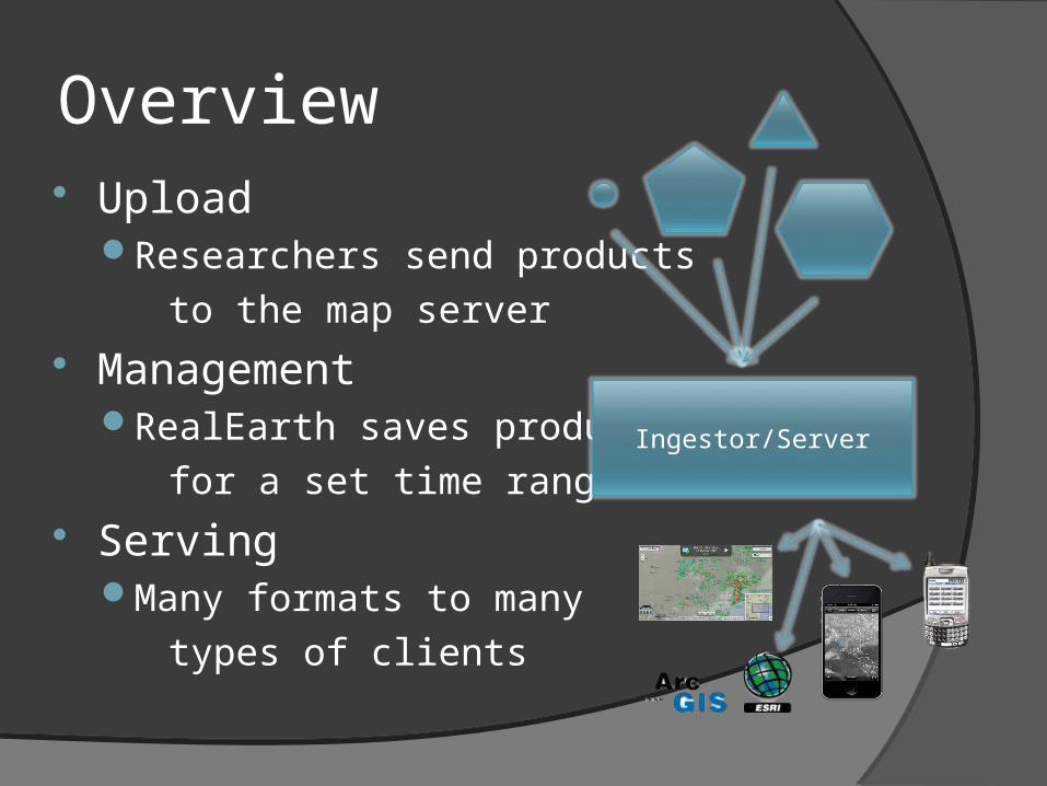
Overview Upload
Researchers send products
to the map server
ManagementRealEarth saves products
for a set time range
ServingMany formats to many
types of clients
Ingestor/Server

Serves
Rasters: images

Serves
Rasters: images Vectors: points
lines and polygons

Serves
Rasters: images Vectors: points
lines and polygons Metadata: text and
layer values

Data Sources CIMSS/SSEC Unidata NESDIS NCEP – AWC,
SPC, NHC & WPC and many more!

Proxy to Other RealEarth VMs
Proxy collects and combines information (tiles, shapes, metadata, etc) from the appropriate host and returns the result to the client
Requests made to gateway on port 80
product6
product3product4
:80
:80
:8001
:8002
:8003
:80
VM Host
Proxy VM

Sharing and Exporting1. Easy sharing with other software
2. Facebook and Twitter integration

Serving Tiles
NWS Enhanced Data Display (EDD)

Selector … our User Interface
Access to over 200 layers Control Animations Zoom and Roam Transparency Mashups

Animations … its all about time
Absolute, Relative or Product Time intervals based on Product Past and/or Forecast

Let’s give it a try …. realearth.ssec.wisc.edu