Rupture of a Himalayan Myth - University of Nevada,...
18
Jan 14, 2018 KUMAHARA et. al. RUPTURE OF A HIMALAYAN MYTH 1 Rupture of a Himalayan Myth 1 2 3 Yasuhiro Kumahara 1 4 [email protected] 5 Steven G. Wesnousky 2 * 6 [email protected] 7 Takashi Nakata 1 8 [email protected] 9 Deepak Chamlagain 2,3 10 [email protected] 11 Prajwal Chandra Neupane 3 12 [email protected] 13 14 15 1 Graduate School of Education, Hiroshima University, 1-1-1, Kagamiyama, Higashi- 16 Hiroshima, Hiroshima 739-8524, Japan 17 2 Center for Neotectonic Studies and Seismological Laboratory, University of Nevada, 18 Reno, NV 89557, USA. 19 3 Department of Geology, Tri-Chandra M. Campus, Tribhuvan University, Nepal 20 * Corresponding author 21 22 Key Points. 23 x Previously cited proof that surface rupture occurred on the HFT in 1934 is incorrect. 24 x The puzzle remains concerning whether or not the 1934 event produced surface rupture. 25 26 Keywords. Himalaya, Earthquakes, Paleoseismology, Tectonics, Seismic Hazard 27 28 29
Transcript of Rupture of a Himalayan Myth - University of Nevada,...
Jan 14, 2018
KUMAHARA et. al. RUPTURE OF A HIMALAYAN MYTH 1
Rupture of a Himalayan Myth 1 2 3 Yasuhiro Kumahara1 4 [email protected] 5 Steven G. Wesnousky2 * 6 [email protected] 7 Takashi Nakata1 8 [email protected] 9 Deepak Chamlagain2,3 10 [email protected] 11 Prajwal Chandra Neupane 3 12
[email protected] 13 14 15
1 Graduate School of Education, Hiroshima University, 1-1-1, Kagamiyama, Higashi- 16 Hiroshima, Hiroshima 739-8524, Japan 17 2 Center for Neotectonic Studies and Seismological Laboratory, University of Nevada, 18 Reno, NV 89557, USA. 19 3 Department of Geology, Tri-Chandra M. Campus, Tribhuvan University, Nepal 20 * Corresponding author 21
22 Key Points. 23
x Previously cited proof that surface rupture occurred on the HFT in 1934 is incorrect. 24 x The puzzle remains concerning whether or not the 1934 event produced surface rupture. 25
26 Keywords. Himalaya, Earthquakes, Paleoseismology, Tectonics, Seismic Hazard 27 28 29
January 4, 2017
KUMAHARA et. al. RUPTURE OF A HIMALAYAN MYTH
2
2
Abstract 30
Reinvestigation of a previous report that the great Mw 8.4 Bihar-Nepal earthquake produced 31
surface rupture along the Himalayan Frontal Thrust (HFT) of Nepal is shown to be incorrect. 32
While it may be viewed as reasonable to suggest that the Main Himalayan Frontal Thrust was the 33
source of the 1934 Bihar-Nepal earthquake on geophysical grounds, substantiating geological 34
evidence that it produced surface rupture along the trace of the HFT remains lacking. 35
36
1. Introduction 37
The Sir Khola (river) of central Nepal crosses the trace of the Himalayan Frontal Thrust 38
(HFT) at the foot of the Siwalik Hills (Figures 1 and 2). Previous study employing 39
geomorphological mapping of fluvial deposits and paleoseismological logging of river-cut cliffs 40
and trench walls concludes that the great Mw 8.4 Bihar-Nepal earthquake of 1934 (Molnar and 41
Deng, 1984) produced upwards of 4-5 meters of surface rupture throw at Sir Khola (Bollinger et 42
al., 2014; Sapkota et al., 2013). The study at Sir Khola is the only published report to claim 43
geologic observations supporting the occurrence of surface rupture during this great earthquake, 44
and is now highly cited as definitive evidence that the source of the Bihar-Nepal earthquake was 45
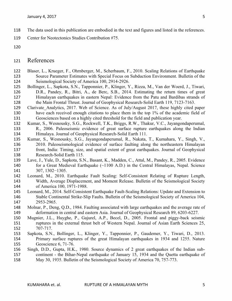
the Himalayan Frontal Thrust (Clarivate_Analytics, 2017). The location and length of surface 46
rupture interpreted in the Sir Khola study is shown as the red line in Figure 1. Our unsuccessful 47
efforts to find decisive and corroborative evidence elsewhere on the previously proposed length 48
of the surface rupture led us to independently re-examine the Sir Khola site. The resulting 49
observations tell a new story. 50
2. The Sir Khola Site 51
Erosion along an outward bend of the Sir Khola (river) has produced a steep cliff that 52
exposes more than 50 m of sheared sand and siltstones of the Tertiary Siwalik group and younger 53
fluvial sediments (Figure 3). It is the study of a portion of this cliff exposure that provided the 54
principal observations for Sapkota et al. (2013) and Bollinger et al. (2014) to conclude the 55
presence of 1934 surface rupture. We re-excavated and cleaned the cliff exposure and also 56
emplaced an additional trench on the surface above the natural exposure (Figure 3). A photo and 57
January 4, 2017
KUMAHARA et. al. RUPTURE OF A HIMALAYAN MYTH
3
3
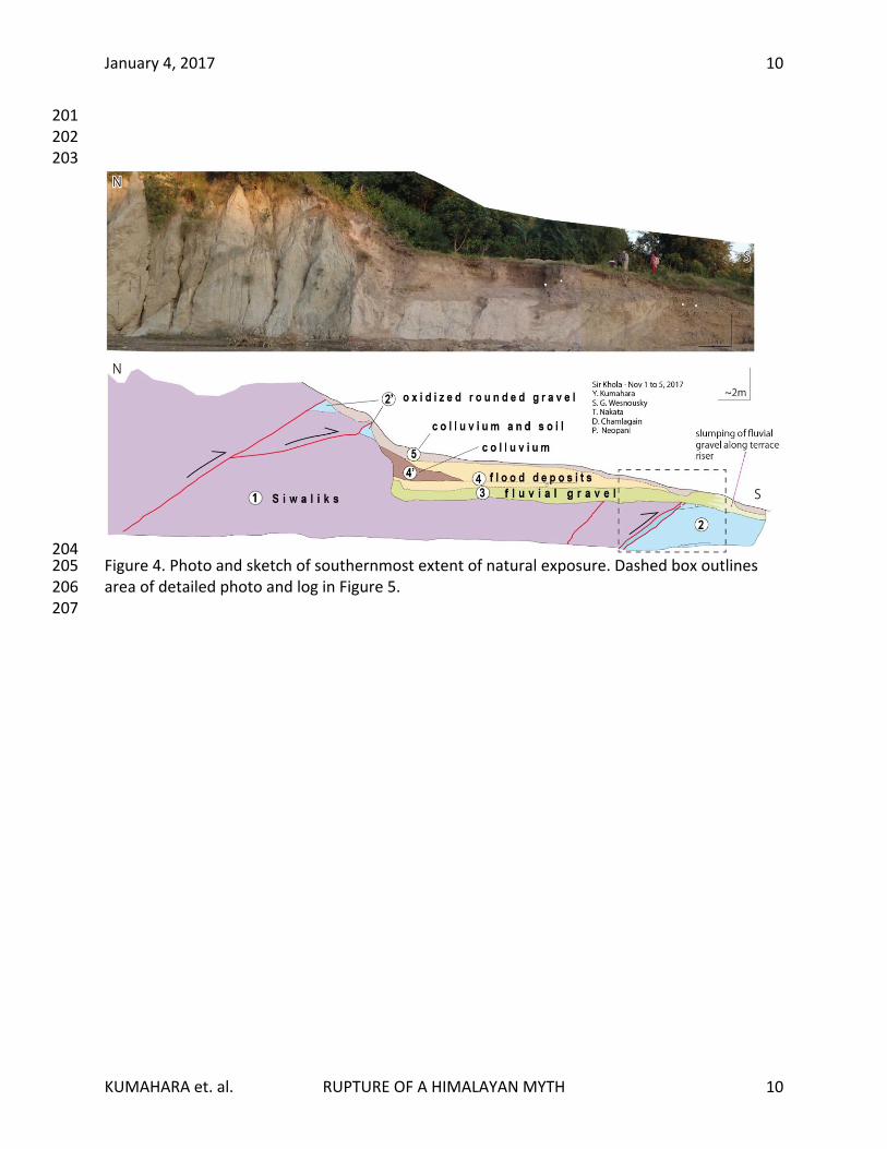
sketch of the cleaned cliff exposure is shown in Figure 4. The Siwalik beds are cut by north-58
dipping thrust faults and shears. The northernmost shear and a splay emplace sheared Siwalik 59
bedrock (unit 1) above packages of oxidized clast-supported fluvial gravel (units 2’). The 60
Siwaliks form a steep cliff below the intersection of the shear and splay with the surface. At the 61
lower part of the cliff, the Siwaliks form an approximately horizontal platform on which rests in 62
erosional contact a moderately sorted rounded pebble and small cobble fluvial gravel (unit 3). 63
The fluvial gravel unit 3 is overlain by unit 4, generally massive and continuous horizons of silt 64
and fine sand that reach a maximum thickness of ~1.5 m, absent of any coarser pebble fraction 65
(unit 4). The northern contact of the fluvial gravel unit 3 is an erosional buttress unconformity 66
with the Siwalik cliff. The silt and fine sand of unit 4 are interpreted as flood (overbank) 67
deposits. The northern limit of the unit 4 overbank deposits is inter-fingered with poorly sorted 68
matrix-supported gravel containing numerous rounded pebbles that form a wedge shape (unit 4’). 69
Unit 4’ is colluvium shed off the adjacent cliff. The entire exposure is capped by darker fine sand 70
and silt taken to be soil developing on the overbank deposits and colluvium being shed off the 71
scarp today. The surface immediately adjacent to the exposure above units 3 to 5 and within ~0.5 72
m of the exposure has previously been disturbed by human activity. The two southernmost faults 73
mapped in the exposure do not break and are capped by fluvial gravel (unit 3). The southernmost 74
thrust fault is underlain by packages and beds of oxidized matrix-supported rounded gravel (unit 75
2) that show a distinctly greater fraction of coarse sands and silts and more oxidation in 76
comparison to fluvial gravel unit 3. The upper part of unit 2 is composed of poorly sorted 77
rounded cobble and pebble gravel. The lower part of unit 2 is much cemented rounded, well-78
sorted cobble, pebble and granule gravel with thin interbeds of massive coarse sand locally 79
exhibiting bedding-parallel laminations. A higher resolution image and log of this portion of the 80
exposure are shown in Figure 5 and discussed below. 81
The principal observation cited to claim evidence of 1934 surface rupture on the HFT by 82
Sapkota et al. (2013) and Bollinger et al (2014) (in interpretation of this same outcrop) is that the 83
fluvial gravel we map as unit 3 is truncated at the fault and displaced downward ~2-3 m along 84
the shear zone to correlate with a horizontal layer within our unit 2 (Supplementary Figure S1). 85
Our re-examination of the outcrop shows this not to be true. Rather, the unit 3 fluvial gravel is 86
observed to form a cap and be continuous across the zone of shear that has emplaced Siwalik 87
unit 1 above the oxidized gravels of unit 2 (Figures 4 and 5). The observation is further 88
January 4, 2017
KUMAHARA et. al. RUPTURE OF A HIMALAYAN MYTH
4
4
confirmed by the exposure provided by emplacement of a trench immediately above the natural 89
exposure (Figures 3 and 6): the fluvial gravel extends continuously across the thrust. Additional 90
photos of this relationship are given in Supplementary Figure S2. The consequence of the 91
observations is inescapable: the primary evidence cited by Sapkota et al. (2013) and Bollinger et 92
al (2014) for the presence of 1934 surface rupture is incorrect. 93
The lack of a fault scarp and folding in young sediments above the trace of the HFT at Sir 94
Khola (Supplementary Figure S3) is conspicuous and inconsistent with all other 95
paleoearthquake trench sites that have reported evidence of earthquakes occurring in the last 96
century (e.g., Kumar et al., 2006; 2010; Lave et al., 2005; Mugnier et al., 2005; Wesnousky et 97
al., 2017a; 2017b; Yule et al., 2006). Each is invariably associated with a fault scarp produced 98
by displacement on the HFT commensurate with the size of an earthquake on the same order as 99
the Mw 8.4 Bihar-Nepal earthquake. Likewise, an Mw 8.4 earthquake would be expected to 100
produce surface ruptures along a fault extending from 10s to 100s of km in length (e.g., Blaser et 101
al., 2010; Leonard, 2010, 2014; Strasser et al., 2010; Wesnousky, 2008). Yet, trenches excavated 102
across the HFT within 10s to 100 m on either side of the Sir Khola site (Sapkota et al., 2013), 103
and at the Marha Khola (Lave et al., 2005) and Thapatol scarps (Bollinger et al., 2014), which 104
are located within ~ 5 to 7 km and also spatially bracket the Sir Khola site, do not show any 105
displacement that is decisively associated with the 1934 earthquake. Limited instrumental 106
observations bearing on the mechanism of the 1934 earthquake also show a nodal plane oblique 107
to the strike of the HFT (Singh and Gupta, 1980). Our finding removes these inconsistencies. 108
3. Conclusion 109
It is our view that there has yet to be found any definitive observation for surface rupture on 110
the HFT during the great Mw 8.4 Bihar-Nepal earthquake of 1934. In this regard, while it may be 111
viewed as reasonable to suggest on geophysical grounds that the Main Himalayan Frontal Thrust 112
was the source of the 1934 Bihar-Nepal earthquake, substantiating geological evidence that it 113
produced surface rupture along the trace of the HFT remains lacking. 114
Acknowledgements 115
This research supported by National Science Foundation (NSF) grant EAR-1345036. Deepak 116
Chamlagain's stay in University of Nevada is supported by the Fulbright Commissions, USA. 117
January 4, 2017
KUMAHARA et. al. RUPTURE OF A HIMALAYAN MYTH
5
5
The data used in this publication are embodied in the text and figures and listed in the references. 118
Center for Neotectonics Studies Contribution #75. 119
120
References 121
Blaser, L., Krueger, F., Ohrnberger, M., Scherbaum, F., 2010. Scaling Relations of Earthquake 122 Source Parameter Estimates with Special Focus on Subduction Environment. Bulletin of the 123 Seismological Society of America 100, 2914-2926. 124
Bollinger, L., Sapkota, S.N., Tapponnier, P., Klinger, Y., Rizza, M., Van der Woerd, J., Tiwari, 125 D.R., Pandey, R., Bitri, A., de Berc, S.B., 2014. Estimating the return times of great 126 Himalayan earthquakes in eastern Nepal: Evidence from the Patu and Bardibas strands of 127 the Main Frontal Thrust. Journal of Geophysical Research-Solid Earth 119, 7123-7163. 128
Clarivate_Analytics, 2017. Web of Science. As of July/August 2017, these highly cited paper 129 have each received enough citations to place them in the top 1% of the academic field of 130 Geosciences based on a highly cited threshold for the field and publication year. 131
Kumar, S., Wesnousky, S.G., Rockwell, T.K., Briggs, R.W., Thakur, V.C., Jayangondaperumal, 132 R., 2006. Paleoseismic evidence of great surface rupture earthquakes along the Indian 133 Himalaya. Journal of Geophysical Research-Solid Earth 111. 134
Kumar, S., Wesnousky, S.G., Jayangondaperumal, R., Nakata, T., Kumahara, Y., Singh, V., 135 2010. Paleoseismological evidence of surface faulting along the northeastern Himalayan 136 front, India: Timing, size, and spatial extent of great earthquakes. Journal of Geophysical 137 Research-Solid Earth 115. 138
Lave, J., Yule, D., Sapkota, S.N., Basant, K., Madden, C., Attal, M., Pandey, R., 2005. Evidence 139 for a Great Medieval Earthquake (~1100 A.D.) in the Central Himalayas, Nepal. Science 140 307, 1302−1305. 141
Leonard, M., 2010. Earthquake Fault Scaling: Self-Consistent Relating of Rupture Length, 142 Width, Average Displacement, and Moment Release. Bulletin of the Seismological Society 143 of America 100, 1971-1988. 144
Leonard, M., 2014. Self-Consistent Earthquake Fault-Scaling Relations: Update and Extension to 145 Stable Continental Strike-Slip Faults. Bulletin of the Seismological Society of America 104, 146 2953-2965. 147
Molnar, P., Deng, Q.D., 1984. Faulting associated with large earthquakes and the average rate of 148 deformation in central and eastern Asia. Journal of Geophysical Research 89, 6203-6227. 149
Mugnier, J.L., Huyghe, P., Gajurel, A.P., Becel, D., 2005. Frontal and piggy-back seismic 150 ruptures in the external thrust belt of Western Nepal. Journal of Asian Earth Sciences 25, 151 707-717. 152
Sapkota, S.N., Bollinger, L., Klinger, Y., Tapponnier, P., Gaudemer, Y., Tiwari, D., 2013. 153 Primary surface ruptures of the great Himalayan earthquakes in 1934 and 1255. Nature 154 Geoscience 6, 71-76. 155
Singh, D.D., Gupta, H.K., 1980. Source dynamics of 2 great earthquakes of the Indian sub-156 continent - the Bihar-Nepal earthquake of January 15, 1934 and the Quetta earthquake of 157 May 30, 1935. Bulletin of the Seismological Society of America 70, 757-773. 158

January 4, 2017
KUMAHARA et. al. RUPTURE OF A HIMALAYAN MYTH
6
6
Strasser, F.O., Arango, M.C., Bommer, J.J., 2010. Scaling of the Source Dimensions of Interface 159 and Intraslab Subduction-zone Earthquakes with Moment Magnitude. Seismological 160 Research Letters 81, 941-950. 161
Wesnousky, S.G., 2008. Displacement and geometrical characteristics of earthquake surface 162 ruptures: Issues and implications for seismic-hazard analysis and the process of earthquake 163 rupture. Bulletin of the Seismological Society of America 98, 1609-1632. 164
Wesnousky, S.G., Kumahara, Y., Chamlagain, D., Pierce, I.K., Karki, A., Gautam, D., 2017a. 165 Geological observations on large earthquakes along the Himalayan frontal fault near 166 Kathmandu, Nepal. Earth and Planetary Science Letters 457, 366-375. 167
Wesnousky, S.G., Kumahara, Y., Chamlagain, D., Pierce, I.K., Reedy, T., Angster, S.J., Giri, B., 168 2017b. Large paleoearthquake timing and displacement near Damak in eastern Nepal on the 169 Himalayan Frontal Thrust. Geophysical Research Letters 44, 8219-8226. 170
Yule, D., Dawson, S., Lave, J., Sapota, S.N., Tiwari, D.R., 2006. Possible evidence for surface 171 rupture of the Main Frontal Thrust during the great 1505 Himalayan earthquake, far-western 172 Nepal. EOS, Trans. American Geophysical Union Fall Meeting. 173
174 175
January 4, 2017
KUMAHARA et. al. RUPTURE OF A HIMALAYAN MYTH
7
7
Figures and Captions 176
177
178 179 Figure 1. (a) Map of Nepal showing location of Sir Khola and age of surface rupture earthquakes 180 reported at sites along the Himalayan Frontal Thrust (HFT). The length of surface rupture for 181 1934 rupture previously indicated in Sapkota et al. (2013) and Bollinger et al. (2014). 182 183 184
January 4, 2017
KUMAHARA et. al. RUPTURE OF A HIMALAYAN MYTH
8
8
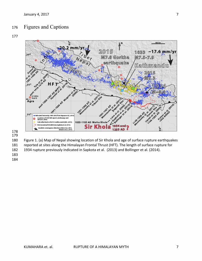
185 186 Figure 2. (upper) Arrows point to previously reported paleoearthquake investigations where the 187 Himlayan Frontal Thrust (HFT, white line with triangles on hanging wall) is mapped to cross Sir 188 Khola and Marha Khola. Here the HFT generally marks the boundary between young floodplain 189 sediments and uplifted Siwalik beds. Satellite image is from Google. (lower) Oblique view of Sir 190 Khola natural exposure. 191

January 4, 2017
KUMAHARA et. al. RUPTURE OF A HIMALAYAN MYTH
9
9
192
193 194
195 196 Figure 3. Oblique view of Sir Khola study site showing reexamined natural exposure and 197 location of an auxiliary trench on the surface above. 198 199 200
January 4, 2017
KUMAHARA et. al. RUPTURE OF A HIMALAYAN MYTH
10
10
201 202 203
204 Figure 4. Photo and sketch of southernmost extent of natural exposure. Dashed box outlines 205 area of detailed photo and log in Figure 5. 206
207

January 4, 2017
KUMAHARA et. al. RUPTURE OF A HIMALAYAN MYTH
11
11
208 Figure 5. Enlarged photo and log illustrates capping of shear by fluvial sand and gravel. Location 209 shown by dashed box in Figure 4. Clasts in exposure each drawn individually in log to illustrate 210 texture. Clasts rotated with long-axis oriented along shear zone are red. Additional photos of 211 exposure shown in Supplementary Figure. 212

January 4, 2017
KUMAHARA et. al. RUPTURE OF A HIMALAYAN MYTH
12
12
213 214 Figure 6. Exposure in auxiliary trench shows shear plane overlain by Siwaliks (between arrows) 215 truncated by continuous exposure of river gravels. Spoils pile of auxiliary trench may be 216 observed in Figure 1. 217
January 4, 2017 1
Supporting Information for 1 2 Rupture of a Himalayan Myth 3 4 5 6 Yasuhiro Kumahara1, Steven G. Wesnousky2 *, Takashi Nakata1, Deepak Chamlagain2,3, and 7 Prajwal C. Neupane3 8 9 1 Graduate School of Education, Hiroshima University, 1-1-1, Kagamiama, Higashi- Hiroshima,1 10 Center for Neotectonic Studies and Seismological Laboaratory, University of Nevada, 11 Reno 89557, USA, Hiroshima 739-8524, Japan, 3 Department of Geology, Tri-Chandra 12 Multiple Campus, Kathmandu, Nepal 13 14 15 Contents of this file 16
17 Figure S1. Photo and log of natural exposure at Sir Khola published in Sapkota et al. (2013) 18
Figure S2a. Images illustrating capping of shear zone. 19
Figure S2b. Enlargement of central grid shown of Figure S2a. 20
Figure S2c. Auxiliary trench exposure. 21
Figure S3. Photos illustrating lack of scarp above shear zone. 22
23

January 4, 2017 2
24
25 26 Figure S1. Photo and log of natural exposure at Sir Khola published in Sapkota et al. (2013). 27
Log reflects interpretation that fluvial gravel units U2 and U3 are offset along the shear zone 28 F1, in contrast to the observations presented in this paper and summarized in Figures 4 and 29 5 of the main manuscript. 30
31 32

January 4, 2017 3
33 34 Figure S2a. Images illustrating capping of shear zone by coarse fluvial gravel and distinct coarse 35
sand layer at the basal contact of fluvial gravel. Enlargement of area encompassed by central 36 grid is shown in Figure S2b. 37
38
January 4, 2017 4
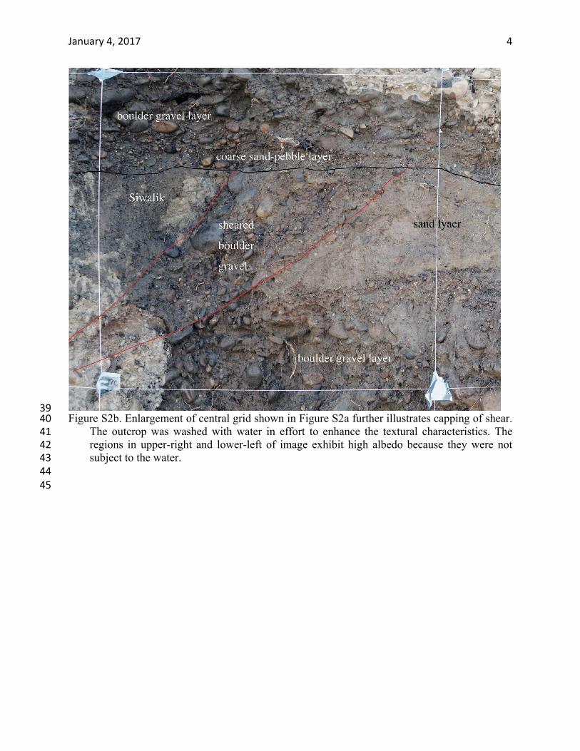
39 Figure S2b. Enlargement of central grid shown in Figure S2a further illustrates capping of shear. 40
The outcrop was washed with water in effort to enhance the textural characteristics. The 41 regions in upper-right and lower-left of image exhibit high albedo because they were not 42 subject to the water. 43
44 45
January 4, 2017 5
46 47
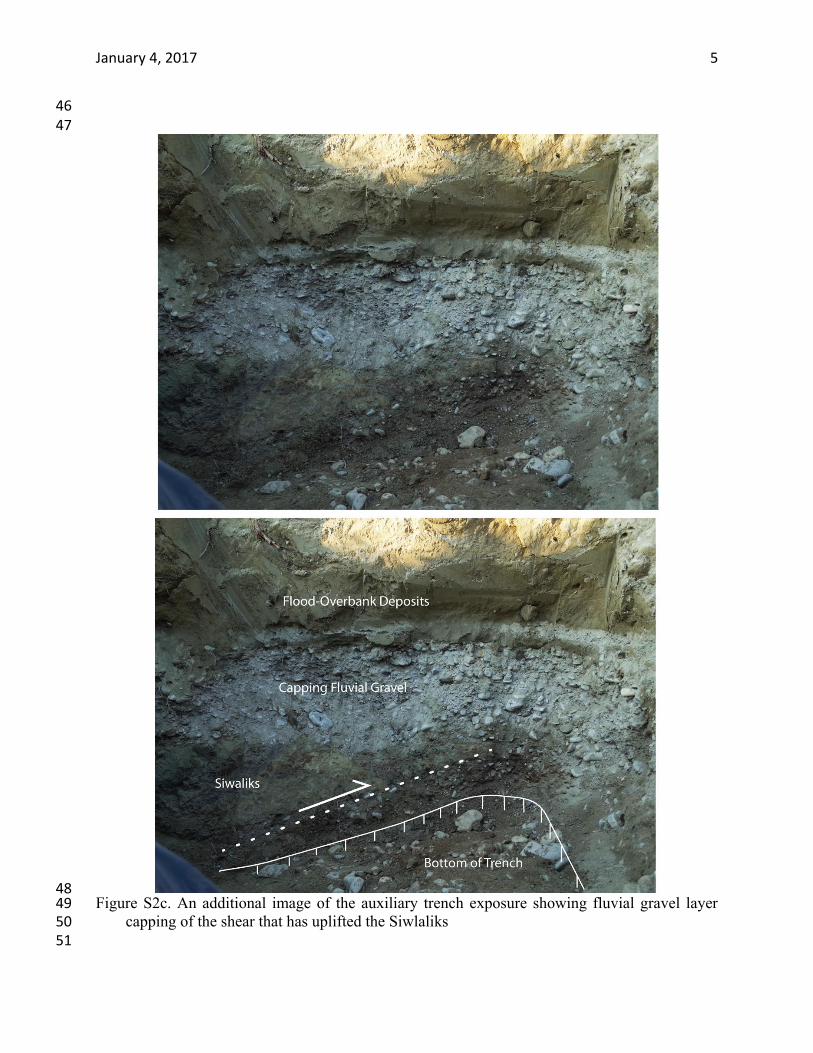
48 Figure S2c. An additional image of the auxiliary trench exposure showing fluvial gravel layer 49
capping of the shear that has uplifted the Siwlaliks 50 51
January 4, 2017 6
52
53
54 55
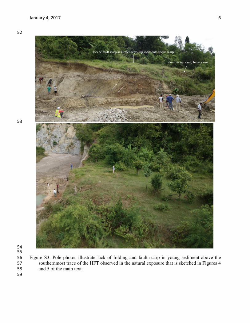
Figure S3. Pole photos illustrate lack of folding and fault scarp in young sediment above the 56 southernmost trace of the HFT observed in the natural exposure that is sketched in Figures 4 57 and 5 of the main text. 58
59