Runway excursion, Boeing 737-3G7, August 25, 2001 · PDF fileRunway excursion, Boeing 737-3G7,...
24
Runway excursion, Boeing 737-3G7, August 25, 2001 Micro-summary: This Boeing 737-3G7 veered off the side of the runway during a landing in foul weather. Event Date: 2001-08-25 at 0111 CDT Investigative Body: National Transportation Safety Board (NTSB), USA Investigative Body's Web Site: http://www.ntsb.gov/ Cautions: 1. Accident reports can be and sometimes are revised. Be sure to consult the investigative agency for the latest version before basing anything significant on content (e.g., thesis, research, etc). 2. Readers are advised that each report is a glimpse of events at specific points in time. While broad themes permeate the causal events leading up to crashes, and we can learn from those, the specific regulatory and technological environments can and do change. Your company's flight operations manual is the final authority as to the safe operation of your aircraft! 3. Reports may or may not represent reality. Many many non-scientific factors go into an investigation, including the magnitude of the event, the experience of the investigator, the political climate, relationship with the regulatory authority, technological and recovery capabilities, etc. It is recommended that the reader review all reports analytically. Even a "bad" report can be a very useful launching point for learning. 4. Contact us before reproducing or redistributing a report from this anthology. Individual countries have very differing views on copyright! We can advise you on the steps to follow. Aircraft Accident Reports on DVD, Copyright © 2006 by Flight Simulation Systems, LLC All rights reserved. www.fss.aero
Transcript of Runway excursion, Boeing 737-3G7, August 25, 2001 · PDF fileRunway excursion, Boeing 737-3G7,...

Runway excursion, Boeing 737-3G7, August 25, 2001
Micro-summary: This Boeing 737-3G7 veered off the side of the runway during alanding in foul weather.
Event Date: 2001-08-25 at 0111 CDT
Investigative Body: National Transportation Safety Board (NTSB), USA
Investigative Body's Web Site: http://www.ntsb.gov/
Cautions:
1. Accident reports can be and sometimes are revised. Be sure to consult the investigative agency for thelatest version before basing anything significant on content (e.g., thesis, research, etc).
2. Readers are advised that each report is a glimpse of events at specific points in time. While broadthemes permeate the causal events leading up to crashes, and we can learn from those, the specificregulatory and technological environments can and do change. Your company's flight operationsmanual is the final authority as to the safe operation of your aircraft!
3. Reports may or may not represent reality. Many many non-scientific factors go into an investigation,including the magnitude of the event, the experience of the investigator, the political climate, relationshipwith the regulatory authority, technological and recovery capabilities, etc. It is recommended that thereader review all reports analytically. Even a "bad" report can be a very useful launching point for learning.
4. Contact us before reproducing or redistributing a report from this anthology. Individual countries havevery differing views on copyright! We can advise you on the steps to follow.
Aircraft Accident Reports on DVD, Copyright © 2006 by Flight Simulation Systems, LLCAll rights reserved.
www.fss.aero

National Transportation Safety Board
FACTUAL REPORTAVIATION
NTSB ID:
Occurrence Date:
Occurrence Type:
Most Critical Injury:
Investigated By:
Location/TimeState Zip Code Local Time Time Zone
Model/SeriesAircraft ManufacturerAircraft Information Summary
Sightseeing Flight: Air Medical Transport Flight:NarrativeBrief narrative statement of facts, conditions and circumstances pertinent to the accident/incident:
Page 1FACTUAL REPORT - AVIATION
Nearest City/Place
Direction From Airport:Distance From Landing Facility:Airport Proximity:
Type of Aircraft
Aircraft Registration Number:
This space for binding
NOTE: The narrative associated with this case is too large for this PDF file. Please return to thequery results page and select the report under the Current Synopsis heading.
NoNo
Airplane737-3G7Boeing
00On Airport
CDT011164153MOKansas City
NTSBAccident
Minor08/25/2001
N306AWCHI01FA292

National Transportation Safety Board
FACTUAL REPORTAVIATION
NTSB ID:
Occurrence Date:
Occurrence Type:
FACTUAL REPORT - AVIATION Page 2
This space for binding
Landing Facility/Approach InformationAirport Name
Runway Surface Type:Runway Surface Condition:
Airport ID:
Type Instrument Approach:
VFR Approach/Landing:
Aircraft InformationAircraft Manufacturer
Airworthiness Certificate(s):
Landing Gear Type:Homebuilt Aircraft? Number of Seats:Engine Type:
- Aircraft Inspection InformationType of Last Inspection
- Emergency Locator Transmitter (ELT) InformationELT Installed? ELT Operated?
Owner/Operator InformationRegistered Aircraft Owner
Operator of Aircraft
Operator Does Business As:- Type of U.S. Certificate(s) Held:Air Carrier Operating Certificate(s):
Operating Certificate:Regulation Flight Conducted Under:Type of Flight Operation Conducted:
Operator Certificate:
Operator Designator Code:
Street Address
City
Street Address
City
ELT Aided in Locating Accident Site?
Time Since Last InspectionHours
Model/Series:Engine Manufacturer:
Date of Last Inspection
Model/Series
Certified Max Gross Wt. Number of Engines:LBS
Serial Number
Airport ElevationFt. MSL
Runway Used Runway Length Runway Width
Rated Power:
Airframe Total TimeHours
State Zip Code
State Zip Code
NoNoNo
Retractable - Tricycle
Scheduled; Domestic; Passenger Only
Part 121: Air Carrier
Flag Carrier/Domestic
AWXA
Same as Reg'd Aircraft Owner
Same as Reg'd Aircraft Owner
85034AZPhoenix
4000 E. Sky Harbor Blvd.AMERICA WEST AIRLINES INC
378752608/2001Continuous Airworthiness
22000 LBS CFM 56-3B2CFM InternationalTurbo Fan
2138500159No
Transport
24633737-3G7Boeing
Full Stop
Visual
Wet
Asphalt
1509500271026MCIKansas City International
Accident
08/25/2001
CHI01FA292
This space for binding
National Transportation Safety Board
FACTUAL REPORTAVIATION
NTSB ID:
Occurrence Date:
Occurrence Type:
FACTUAL REPORT - AVIATION Page 3
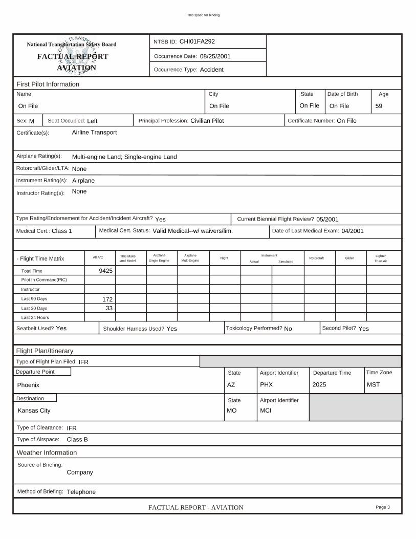
First Pilot InformationName
Sex: Seat Occupied:
City
Principal Profession: Certificate Number:
State Date of Birth Age
Certificate(s):
Airplane Rating(s):Rotorcraft/Glider/LTA:Instrument Rating(s):
Instructor Rating(s):
Type Rating/Endorsement for Accident/Incident Aircraft? Current Biennial Flight Review?Medical Cert. Status:
- Flight Time Matrix
Medical Cert.: Date of Last Medical Exam:
Glider LighterThan Air
RotorcraftInstrumentActual Simulated
AirplaneMult-Engine NightAirplane
Single EngineThis Makeand Model
All A/C
Total TimePilot In Command(PIC)InstructorLast 90 DaysLast 30 DaysLast 24 Hours
Seatbelt Used? Shoulder Harness Used? Toxicology Performed? Second Pilot?
Departure Time Time ZoneState Airport Identifier
State Airport Identifier
Type of Flight Plan Filed:Departure Point
Destination
Flight Plan/Itinerary
Type of Clearance:Type of Airspace:
Weather InformationSource of Briefing:
Method of Briefing: Telephone
Company
Class B
IFR
MST2025
MCI
PHX
MO
AZ
Kansas City
Phoenix
IFR
YesNoYesYes
33172
9425
04/2001Valid Medical--w/ waivers/lim.Class 1
05/2001Yes
None
Airline Transport
Airplane
Multi-engine Land; Single-engine Land
None
On FileCivilian PilotLeftM
59On FileOn FileOn FileOn File
Accident
08/25/2001
CHI01FA292

This space for binding
National Transportation Safety Board
FACTUAL REPORTAVIATION
NTSB ID:
Occurrence Date:
Occurrence Type:
FACTUAL REPORT - AVIATION Page 4
Weather InformationWOF ID Observation Time
Sky/Lowest Cloud Condition:
Time Zone WOF Elevation
Ft. MSL
WOF Distance From Accident Site
NMFt. AGL Condition of Light:
Direction From Accident Site
Deg. Mag.
Altimeter: "Hg
Density Altitude: Ft.
Visibility: SM
Wind Direction:
Ft. AGL
Weather Condtions at Accident Site:
°C°C Dew Point:
Gusts:
Lowest Ceiling:
Temperature:
Wind Speed:
Visibility (RVR): Ft.Restrictions to Visibility:
Type of Precipitation:
Accident InformationAircraft Damage:
Visibility (RVV) SM
Aircraft Fire:
Intensity of Precipitation:
Aircraft Explosion
Classification:
- Injury Summary MatrixFirst Pilot
Second PilotStudent Pilot
Check PilotFlight Engineer
Cabin AttendantsOther Crew
Passengers- TOTAL ABOARD -
Other Ground- GRAND TOTAL -
Fatal Serious Minor None TOTAL
Flight Instructor
59581
59581
54531
33
11
11
U.S. Registered/U.S. Soil
NoneNoneSubstantial
Rain
None
Heavy
Instrument Conditions4
2124302222
29.9011800Broken
Night/Dark1300Few
001026CDT0113MCI
Accident
08/25/2001
CHI01FA292

This space for binding
National Transportation Safety Board
FACTUAL REPORTAVIATION
NTSB ID:
Occurrence Date:
Occurrence Type:
FACTUAL REPORT - AVIATION Page 5
Administrative InformationInvestigator-In-Charge (IIC)
Additional Persons Participating in This Accident/Incident Investigation:Mark WilliamsFAA InspectorFAA10015 N. Executive Hills Blvd.Kansas City, KS 64153
Chip BornsteinFlight Safety ManagerAmerica West4000 East Sky Harbor Blvd.Phoenix, AZ 85022
Mark SmithSafety InvestigatorBoeing535 Garden Ave. North, MS 67-PRRenton, WA 98055
Geoff GrayALPA Accident InvestigatorAmerica West340 E. Tierra Buena LanePhoenix, AZ 85022
Jim Silliman
Accident
08/25/2001
CHI01FA292

08/24/2006 10:06 AMCHI01FA292
Page 1 of 18http://www.ntsb.gov/ntsb/brief2.asp?ev_id=20010830X01825&ntsbno=CHI01FA292&akey=1
CHI01FA292
HISTORY OF FLIGHT
On August 25, 2001, at 0111 central daylight time (cdt), a Boeing 737-3G7, N306AW, Flight 598, operatedby America West Airlines, Inc. (AWA), sustained foreign object damage (FOD) to both engines duringlanding when it veered off the left side of runway 27 (9,500 feet by 150 feet, wet grooved asphalt) at theKansas City International Airport (MCI), Kansas City, Missouri. The captain, first officer, three flightattendants, and 53 passengers were not injured. One passenger reported a minor injury. Airport Rescue andFire Fighting (ARFF) personnel responded and confirmed there was no smoke, fire, or fuel coming from theairplane. An emergency evacuation was not conducted. The passengers were kept on board the airplane untila bus arrived to transport them to the terminal. The Title 14 Code of Federal Regulations Part 121scheduled, domestic flight originated from Phoenix Sky Harbor International Airport (PHX), Phoenix,Arizona, on August 24, 2001, at 2025 mountain standard time (mst), and was en route to MCI. Instrumentmeteorological conditions prevailed at that time. The flight was on an IFR flight plan.
The captain and first officer reported for duty at PHX on August 24, 2001, at 1340 mst for the start of a twoday trip, Trip 1050. Four flight legs were scheduled on August 24th. The first scheduled takeoff was at 1425mst, and the final landing of the fourth leg of flight occurred at 0111 cdt at MCI. The flight crew's duty timewas 10 hours and 38 minutes.
On August 24, 2001, the first three flight legs on Trip 1050 were completed without incident, and theairplane arrived back at PHX at 1948 mst at the completion of the third leg of flight. The scheduleddeparture time for Flight 598 was 2023 mst, and the actual departure time was 2025 mst.
The pilots were interviewed by America West Airlines (AWA) personnel, representatives of the Air LinePilots Association, and by an inspector from the Federal Aviation Administration. The AWA report statedthe following information:
"The first officer was acting as the Pilot Flying (PF). The aircraft was operating normally with the exceptionof the auto thrust system that was placarded inoperative under the provisions of the minimum equipment list(MEL). The weather was clear until approximately 30 minutes prior to landing when the flight begandeviating around convective activity using onboard weather radar and vectors from Air Traffic Control(ATC). Several runway changes were assigned by ATC. The winds were updated to approximately from theWest at 8 knots and the visibility was believed to have been reported between 6 and 8 miles. ATC offeredRunway 27 and the crew accepted. The first officer briefed the captain on a visual approach 'backed up bythe ILS.'
The aircraft was configured for a 'flaps 30' landing and the landing checklist was completed including thearming of the speed brakes.
During the approach, the flight encountered heavy rain decreasing to light or moderate rain approximately 6miles from the runway. The captain reported the approach lights in sight approximately 2 miles fromtouchdown and reported the runway lights in sight almost immediately thereafter. Between 500 and 1,000feet above touchdown, the captain advised the first officer that the flight management system (FMS) wasindicating the winds to be from 320 degrees at 8 knots.

08/24/2006 10:06 AMCHI01FA292
Page 2 of 18http://www.ntsb.gov/ntsb/brief2.asp?ev_id=20010830X01825&ntsbno=CHI01FA292&akey=1
The captain described the weather conditions 'as advertised.' The first officer indicated that the visibility wasworse than he had anticipated.
On short final, the wipers were turned on and the auto brakes were set to '2.'
The first officer reported that during the flare and landing, the runway appeared to absorb the light from theaircraft's landing lights and the runway was very black. Both pilots reported the touchdown to be normalexcept for the absence of the sensation of touchdown. The reversers were activated normally. The crew didnot recall whether or not the reverser lights came on or if the speed brakes activated.
The first officer reported that sometime after the nose wheel was lowered to the runway, he saw the left-siderunway lights entering his peripheral view indicating to him that the aircraft was tracking to the left whileremaining parallel to the runway centerline. The captain attempted to assist the first officer by using thesteering tiller.
The aircraft exited the left side of the runway. The first officer stowed the reversers. As soon as the aircraftcame to a complete stop, the captain made a public address (PA) announcement commanding the passengersto 'Remain seated, the situation is under control.' The first officer notified ATC of the situation andrequested the Airport Rescue and Fire Fighting (ARFF) equipment. After the ARFF crew reported nosignificant hazards, the captain started the Auxiliary Power Unit (APU) until the passengers could bedeplaned using portable stairs." (See AWA report of pilots' statements)
The captain in a written statement reported the following:
"I was the Captain, non-flying pilot, on flight 598 (PHX-MCI) on the night of August 24, 2001. MCI hadscattered thunderstorms and rain in the area. We were vectored to the ILS for runway 27, and on finalapproach experienced light to moderate rain with winds reported out of the west at eight knots. I saw theapproach lights at approximately two miles from the runway and the runway lights immediately thereafter.The approach and landing appeared normal; however on touchdown, the aircraft shifted to the left side ofthe runway and ultimately partially exited the runway into the field, despite using right aileron, rudder, andtiller inputs. Once stopped, we contacted the tower and asked for emergency vehicles, and then notified theCompany. Passengers were de-planed by emergency crews and aircraft control handed off the MCI stationpersonnel."
The first officer in a written statement reported the following:
"I was the First Officer, flying pilot, on flight 598 (PHX-MCI) on the night of August 24, 2001. We werevectored to the ILS for runway 27, and on final approach experienced light to moderate rain. Upontouchdown, the aircraft gently began to shift to the left edge of the runway and ultimately partially exitedthe runway into the field, despite using right aileron and rudder inputs. Once stopped, we contacted thetower and asked for emergency vehicles, and then notified the Company. Passengers were de-planed byemergency crews and aircraft control handed off to MCI station personnel."
One of the flight attendants reported the following in a written statement:
"As we were approaching the runway in Kansas City the first flight attendant and I noticed it was rainingpretty hard outside, but other than that everything seemed normal. Once we touched down I felt a few

08/24/2006 10:06 AMCHI01FA292
Page 3 of 18http://www.ntsb.gov/ntsb/brief2.asp?ev_id=20010830X01825&ntsbno=CHI01FA292&akey=1
bumps and then the plane seemed to skid. At that point I felt a huge bump and a few seconds later we cameto a stop. The first [flight attendant] called the flight deck after waiting a few seconds. As soon as she calledthe flight deck one of the pilots came over the PA and said, 'Remain seated. Situation under control.' Thepassengers were the first ones to mention we might be off the runway. While I was talking to the passengersfrom my jump seat the first flight attendant was busy talking to the pilots. The emergency crew at KansasCity arrived on the scene in less than a minute. With the help of the America West personnel in MCI andthe emergency crew, the passengers deplaned out of door 1R, down portable stairs and on to waiting busesthat took them to the terminal."
PERSONNEL INFORMATION
The captain held an airline transport pilot certificate with airplane single engine and multi-engine landratings. He held a First Class Medical Certificate that was issued on April 17, 2001. He had a total of about9,425 flight hours. He had flown 172 hours in the last 90 days and 33 hours in the last 30 days.
The first officer held an airline transport pilot certificate with airplane single engine and multi-engine landratings. He held a First Class Medical Certificate that was issued on December 12, 2000. He had a total ofabout 11,740 flight hours. He had flown 238 hours in the last 90 days and 51 hours in the last 30 days.
AIRCRAFT INFORMATION
The airplane was a Boeing 737-3G7, serial number 24633. The CFM 56-3B2 engines delivered 22,000pounds of thrust each. The airplane's last maintenance inspection was a continuous airworthiness inspectionconducted on August 22, 2001. The airplane had flown 26 hours since the last inspection, and had a totaltime of 37,878 hours.
The airplane had a maximum gross weight of 138,500 lbs. An AWA engineer reported that based on anestimated landing weight of 95,071 lbs. and a landing index of 56.7, the %MAC [mean aerodynamic chord]was approximately 17.4%. This information was predicted upon the planned trip fuel burn of 13,100 lbs.
METEOROLOGICAL CONDITIONS
At 0031 cst, the Automatic Terminal Information Service (ATIS) information Quebec was: winds 040degrees at 5 knots, 7 miles visibility, thunderstorm and light rain, few clouds at 2,000 feet, ceiling 6,000broken cumulonimbus, 9,000 feet overcast, temperature 23 degrees [Celsius], dew point 22 degrees[Celsius]., altimeter 29.87. Remarks: Frequent lightning in clouds, clouds to ground all quadrants,thunderstorm overhead moving northeast. Runway use program in effect. Arrivals expect visual approachrunway 19L.
At 0054 cst, ATC issued the flightcrew a weather update, which was: "few clouds at 1,200 feet, ceiling6,000 feet broken, 8,500 feet overcast, visibility 10 miles light rain. Wind three six zero at eight, altimeter29.88." The controller subsequently issued the flightcrew windshear alerts of 20 knots within 2 miles of theairport and heavy rain at the airport.
At 0113 cst, the special weather observation at MCI was: winds 030 at 4 knots, 1 mile visibility, heavythunderstorms and rain showers, mist, few clouds at 1,300, broken layer at 1,800 feet, overcast 7,000 feet,cumulonimbus clouds, temperature 22 degrees C, dew point 22 degrees C, altimeter 29.90. Remarks:

08/24/2006 10:06 AMCHI01FA292
Page 4 of 18http://www.ntsb.gov/ntsb/brief2.asp?ev_id=20010830X01825&ntsbno=CHI01FA292&akey=1
thunderstorm began 0106. Frequent lightning in cloud cloud to ground cloud to cloud cloud to air allquadrants. Thunderstorm overhead moving northeast.
The Automated Surface Observation Systems (ASOS) winds reported at 0100 were variable at 4 knotsgusting to 15 knots. The ASOS winds reported at 0105 were variable at 4 knots. The ASOS winds reportedat 0110 were 260 degrees at 5 knots. The ASOS winds reported at 0115 were 030 degrees at 6 knots.
The ASOS rain gauge (located about 8,000 feet west-northwest from the touchdown point) data indicatedthat 0.42-inch of rain fell between 0100 and 0111. The ASOS one-minute precipitation values during theperiod from 0100 to 0113, were:
Time Rain (inches)
0100 0.00
0101 0.01
0102 0.04
0103 0.02
0104 0.03
0105 0.03
0106 0.06
0107 0.02
0108 0.01
0109 0.05
0110 0.07
0111 0.08
0112 0.03
0113 0.02
The National Weather Service weather radar and the FAA Terminal Doppler Weather Radar indicated thatlevel 4 and level 5 thunderstorms were present in the vicinity of MCI at the time of the accident.
Convective SIGMET 16C, issued August 24, 2255 cdt, and valid until August 25, 0055 cdt, stated thefollowing information that covered Missouri, Kansas, and Nebraska: From 40SSE SLN-60E ICT-70NEGAG-50ESE GCK-40SSE SLN. Area severe thunderstorms move from 330 degrees at 20 knots. Tops

08/24/2006 10:06 AMCHI01FA292
Page 5 of 18http://www.ntsb.gov/ntsb/brief2.asp?ev_id=20010830X01825&ntsbno=CHI01FA292&akey=1
above FL450. Hail to 1 inch…wind gusts to 50 knots possible. (See National Transportation Safety Board(NTSB) Meteorology Factual Report)
RUNWAY INFORMATION
Runway 27 at MCI is a 9,500 feet by 150 feet grooved asphalt runway with a one-degree transverse slopecrowned at the centerline. At 3,200 feet from the threshold, the white edge stripe defining the official edgeof the runway is 73 feet from the centerline. A paved shoulder varies along the length of the runway, andhas an unknown slope. The transverse grooves in the pavement extend to a width of 65 feet from runwaycenterline. The runway surface beyond a width of 65 feet to the pavement edge is un-grooved pavementwith an unknown slope. (See Boeing Letter, dated November 12, 2001.)
FLIGHT RECORDERS
The NTSB Cockpit Voice Recorder (CVR) Group Chairman's Factual Report stated, "The recordingappeared to start approximately fifteen minutes after the accident while passengers were still on the aircraftand continued until they had deplaned. Very little conversation between crewmembers was recorded. Therecording ended as the crew left the cockpit." (See NTSB CVR Group Chairman's Factual Report)
The Flight Data Recorder (FDR) was sent to the NTSB Vehicle Recorders Division for readout. The readoutof the FDR revealed the following:
1. At 189846 seconds, the autopilot was disengaged.
2. Over the next several seconds, glideslope and localizer deviation values increased with localizer deviationreaching 0.4 dots (right) at 189859 seconds and glideslope deviation reaching 2.7 dots (up) the followingsecond.
3. At 189877 seconds, with a groundspeed of 129 knots and a magnetic heading of 269.6º, verticalacceleration increased to 1.401 g's, consistent with touchdown.
4. The following second, the value for spoiler number 2 was recorded as 19.7º. One second later, the valuefor spoiler number 7 was 24.6º. Also during this timeframe, the FDR indicated the left and right thrustreversers for both engines were deployed.
5. At 189880 seconds and for the following two seconds, rudder pedal position indicated input from the rightpedal, followed by the left pedal, and then the right pedal. Recorded values for rudder position during thistime are consistent with these rudder pedal movements.
6. The airplane's heading increased to the right, reaching 278.8º at 189881 seconds while the airplaneexperienced 0.304 g's of lateral acceleration to the right.
7. At 189882 seconds, longitudinal acceleration reached -0.670 g's and the airplane had a left roll angle of3.5º.
8. The following second, the airplane rolled to the right 2.5º, while vertical acceleration dropped to itslowest value of 0.151 g's and then increased to its highest value of 1.668 g's.
08/24/2006 10:06 AMCHI01FA292
Page 6 of 18http://www.ntsb.gov/ntsb/brief2.asp?ev_id=20010830X01825&ntsbno=CHI01FA292&akey=1
9. Magnetic heading continued to increase, reaching 284.1º at 189891seconds. Two seconds later,groundspeed indicated the airplane came to rest. (See the NTSB Specialist's Factual Report of InvestigationSolid State Digital Flight Data Recorder Report)
WRECKAGE AND IMPACT INFORMATION
The inspection of runway 27 revealed tire skid marks 3,201 feet from the threshold of runway 27. They were90 feet long. They began about 53 feet left of the runway centerline and they ended 62 feet 11 inches fromcenterline. One of the skid marks crossed over the base of a broken taxiway light. The left main landinggear skid mark left the pavement for the first time at 4,157 feet from the runway threshold and 103 feet 4inches from the centerline. It was on the southwest side of Echo Taxiway and the runway 9/27 intersection.The left skid marks were not visible on Foxtrot taxiway that crossed runway 27. The left main landing geartire mark reappeared in the grass 15 feet west of the Foxtrot taxiway skirt. The right main landing gear leftthe pavement of the runway skirt at 4,673 feet from the runway threshold and 97 feet 8 inches from therunway centerline. The airplane came to a rest at 5,213 feet from the threshold of runway 27.
The inspection of the airplane revealed that both engines received foreign object damage (FOD).
TESTS AND RESEARCH
The NTSB provided the Boeing Company with the raw data from the FDR. The Boeing review of the FDRdata revealed that the airplane was on a stabilized approach with the autopilot engaged. About 200 feetabove ground level (agl), the autopilot was disconnected and the airplane was flown manually. After theautopilot disconnect, the airplane began drifting left and above glide slope. The airplane crossed the runwaythreshold about 57 feet agl, offset about 65 feet left of centerline, but the ground track was being correctedback toward centerline. A flare was initiated about 600 feet from the runway threshold and about 35 feet agl.During the flare, the ground track achieved the centerline, but deviated back to the left before main geartouchdown, which occurred about 3,200 feet from the runway threshold. At touchdown, the left main gearwas about 56 feet left of centerline with an airplane ground track of about 5 degrees to the left. Within 2seconds of touchdown (about 300 feet of travel), the left main gear crossed the white runway edge stripe,and within 5 seconds of touchdown (about 1,000 feet of travel), the left main gear departed the pavedsurface. A nearly full right rudder input was made about 3,450 feet from the runway threshold after maingear touchdown. The airplane departed the runway surface before the ground track altered back to the right.
The Boeing report also stated that the FDR data indicated the flight spoiler deployment after touchdown wasabout half the expected deflection. An inspection revealed the speedbrake lever cable was miss-rigged,which caused the partial deployment of the speed brake lever by the auto-speedbrake actuator. It wasconfirmed that the speed brake lever traveled far enough to deploy the ground spoilers. The pilots reportedthey had set Auto-Brakes 2. The FDR data indicated a longitudinal deceleration profile from touchdown topavement exit that was consistent with the Auto-Brakes 2 setting. This implies that hydroplaning was notoccurring and that partial flight spoiler deployment did not adversely affect landing performance. (SeeBoeing Letter dated November 12, 2001)
A representative from the Michelin Tire Company examined the four Michelin H40x14.5-19/24.225 mainlanding gear tires that were removed from the airplane for inspection. The tires were still mounted to their

08/24/2006 10:06 AMCHI01FA292
Page 7 of 18http://www.ntsb.gov/ntsb/brief2.asp?ev_id=20010830X01825&ntsbno=CHI01FA292&akey=1
wheels. He reported, "I observed no rubber reversion on any tire. There was no evidence of viscoushydroplaning or dynamic hydroplaning… . Significant cuts, tears and chunking, however, were seen on thetires. This FODing was the result, I was told, of the airplane rolling over a raised concrete curb during itsdeparture from the paved runway."
A Senior Research Engineer from the NASA Langley Research Center, Structural Dynamics Branch,examined the data that concerned hydroplaning and reported the following:
"I do not think viscous or dynamic hydroplaning and/or reverted rubber skidding were significant factors inthis incident because:
1) Tire photographs that I saw and the Michelin tire representative's inspection of the actual tires indicatedno evidence of tread reversion on any landing gear tires.
2) Tire inflation pressure does play a major role in dynamic hydroplaning development but the runwaysurface type and cross-slope, the direction of the crosswind, and the recorded rainfall amounts would notcontribute to a flooded (greater than 0.1 in. water depth) runway condition.
3) Viscous hydroplaning and reverted rubber skidding both require a very smooth, low macrotexturepavement surface such as possibly the white runway shoulder paint stripe but the incident aircraft tires wereon this paint stripe a relatively short time in respect to the total time from touchdown to a stop.
4) Worn tire treads are more susceptible to hydroplaning than new tires but lack of vertical load, i.e., lessthan full spoilers, on these tires could be a much greater factor in determining the amount of braking andsteering forces."
The America West Airlines B-737 Fleet Manager reported the following information concerning theaircraft's weather radar system:
"Although the crew of flight 598 did not report a problem with the radar, I noted a possible discrepancyduring the reposition flight to PHX. The radar return appeared weak while painting weather returns. Groundreturns appeared normal. The radar was removed for bench testing and no discrepancies were noted."
The America West Airlines B737 Operations Manual, Supplementary Normal Procedures, states thefollowing information for Landing on Wet or Slippery Runways:
"Refer to AWA Performance Book for definitions and limitations of wet or slippery runways.
Operate the airplane during the approach in a way that will minimize stopping requirements after touchdownwithout running the risk of landing short.
Maintain close control over approach speeds and maintain recommended speeds for the current conditions.The recommended wind additives (1/2 the steady wind plus all the gust factor to a maximum of 20 knots)provide adequate safety margins for both the approach and the landing roll.
Control Glidepath so that touchdown occurs on the 1000 foot point (Fixed Distance Marker). The airplaneshould be flown firmly onto the runway at the aiming point even if airspeed is excessive. If an
08/24/2006 10:06 AMCHI01FA292
Page 8 of 18http://www.ntsb.gov/ntsb/brief2.asp?ev_id=20010830X01825&ntsbno=CHI01FA292&akey=1
unsatisfactory approach is likely to result in a long landing, GO AROUND and make a second approach.Once the aircraft has been landed and stopping efforts begun, a go-around attempt is not recommended.
WARNING
A full stop landing must be made after thrust reverse has been initiated. Do not attempt a go-around!
If the wing anti-ice system is inoperative and large ice formations exist on the wing leading edge devicesadd 10 knots to the reference speed to maintain normal handling characteristics."
The America West Airlines B737 Operations Manual, Normal Procedures, states the following informationfor Approach Gate/Approach Requirements:
"The approach gate is a point 500 feet above TSZE (VMC) or 500 feet above minimums (IMC) at whichpoint the aircraft must be configured for landing, on speed and be in position to land.
After the approach gate, the PNF will alert the PF when any deviation limit is approached by stating,'LOCALIZER,' 'GLIDESLOPE,' 'AIRSPEED,' 'SINK RATE,' OR 'ALTITUDE' (AS APPROPRIATE). Animmediate go-around will be executed if any of the deviation limits listed below are exceeded.
VMC:
Airspeed 10 knots below or above target (momentary excursions from these values are acceptable undergusty wind conditions).
Greater that 1000 fpm sink rate, unless briefed for a greater fpm descent.
IMC:
Airspeed 10 knots below or above target (momentary excursions from these values are acceptable undergusty wind conditions).
Airspeed below Vref.
Greater than 1000 fpm sink rate, unless briefed for a greater fpm descent.
Localizer displacement more than 1 dot.
Glideslope displacement greater than 1 dot.
Any navigation radio or flight instrument failure which will affect the ability to safely complete theapproach.
Flight instrument crosscheck shows significant disagreement.
CAUTION

08/24/2006 10:06 AMCHI01FA292
Page 9 of 18http://www.ntsb.gov/ntsb/brief2.asp?ev_id=20010830X01825&ntsbno=CHI01FA292&akey=1
Ducking below the G/S is NOT acceptable. During low visibility approaches, it may cause high rates ofdescent which are not readily apparent from airspeed or vertical speed indications and may not be noticeduntil too late."
ADDITIONAL INFORMATION
Parties to the investigation included the Federal Aviation Administration, America West Airlines, TheBoeing Company, and the Air Lines Pilots Association.

08/24/2006 10:06 AMCHI01FA292
Page 10 of 18http://www.ntsb.gov/ntsb/brief2.asp?ev_id=20010830X01825&ntsbno=CHI01FA292&akey=1

08/24/2006 10:06 AMCHI01FA292
Page 11 of 18http://www.ntsb.gov/ntsb/brief2.asp?ev_id=20010830X01825&ntsbno=CHI01FA292&akey=1

08/24/2006 10:06 AMCHI01FA292
Page 12 of 18http://www.ntsb.gov/ntsb/brief2.asp?ev_id=20010830X01825&ntsbno=CHI01FA292&akey=1

08/24/2006 10:06 AMCHI01FA292
Page 13 of 18http://www.ntsb.gov/ntsb/brief2.asp?ev_id=20010830X01825&ntsbno=CHI01FA292&akey=1

08/24/2006 10:06 AMCHI01FA292
Page 14 of 18http://www.ntsb.gov/ntsb/brief2.asp?ev_id=20010830X01825&ntsbno=CHI01FA292&akey=1

08/24/2006 10:06 AMCHI01FA292
Page 15 of 18http://www.ntsb.gov/ntsb/brief2.asp?ev_id=20010830X01825&ntsbno=CHI01FA292&akey=1

08/24/2006 10:06 AMCHI01FA292
Page 16 of 18http://www.ntsb.gov/ntsb/brief2.asp?ev_id=20010830X01825&ntsbno=CHI01FA292&akey=1

08/24/2006 10:06 AMCHI01FA292
Page 17 of 18http://www.ntsb.gov/ntsb/brief2.asp?ev_id=20010830X01825&ntsbno=CHI01FA292&akey=1

08/24/2006 10:06 AMCHI01FA292
Page 18 of 18http://www.ntsb.gov/ntsb/brief2.asp?ev_id=20010830X01825&ntsbno=CHI01FA292&akey=1
Use your browsers 'back' function to return to synopsisReturn to Query Page