Rugeley Power Station Development Brief SPD
48
Rugeley Power Station Development Brief Supplementary Planning Document Cannock Chase District Council & Lichfield District Council Adopted 20 February 2018
Transcript of Rugeley Power Station Development Brief SPD

Rugeley Power Station
Development Brief
Supplementary Planning Document Cannock Chase District Council & Lichfield District Council
Adopted 20 February 2018
1

July 2017
Rugeley Power Station Development Brief - Supplementary Planning Document
1 Introduction 3
2 Site Analysis 6
3 Policy Context 26
4 Development Principles 32
5 Delivery & Implementation 41
Appendices
A LDC Planning Policy 42
B CCDC Planning Policy 46
Co
nte
nts

July 2017
3 Rugeley Power Station Development Brief - Supplementary Planning Document
1 Introduction
Background
1.1 The Rugeley Power Stations were a
series of two coal fired power stations
located to the east of Rugeley adjacent to
the River Trent traversing the boundary
between Cannock Chase District and
Lichfield District. Rugeley Power Station A
was decommissioned during 1994 and
demolished in 1996 with residential
development still ongoing to replace the
facility.
1.2 This Development Brief relates
primarily to Rugeley Power Station B
although it does encompass part of the
former Power Station A in Lichfield District
(the site of the former Borrow Pit). Rugeley
Power Station B was commissioned to work
alongside Rugeley Power Station A in 1970.
It was announced in February 2016 that due
to a deterioration in market conditions the
Station would cease operating and it closed
in June 2016. The Station and its supporting
infrastructure is currently being
decommissioned with demolition to follow.
It is anticipated demolition will commence
in 2018 and take up to two years.
1.3 This Development Brief sets out the
joint aspirations of Lichfield District Council
(LDC) and Cannock Chase District Council
(CCDC) for the redevelopment of the
Rugeley Power Station site.
1.4 The development of the former
Rugeley Power Station site supports the
redevelopment of a significant brownfield
site and creates a logical extension to the
East of Rugeley Strategic Development Area
(SDA) as allocated for development within
Lichfield District Council’s Local Plan
Strategy. The site will provide physical and
social integration of new development with
the adjacent residential development
(Former Rugeley Power Station A) and the
existing settlement of Rugeley.
1.5 The overall aim for the site is to create
a well-designed mixed use development
which incorporates market housing,
affordable housing, self-build housing,
employment provision, education provision
and open space and recreational facilities.
It is envisaged that the new development
will become a popular residential
neighbourhood and place of work, creating
a network of pedestrian and cycle routes
and open spaces which connect the site with
the surrounding area and respond to the
local context.
Purpose and Scope
1.6 A Supplementary Planning Document
(SPD) is a planning policy document that
supports a policy in an adopted Local Plan.
SPDs fall into two categories: the first is
policy supporting a District-wide objective,
the second is policy for a specific site or
area, such as this SPD.
1.7 This SPD aims to assist with the
delivery of Lichfield District Council’s Local
Plan Strategy Core Policy 1, particularly
delivery of 10,030 dwellings over the plan
period to 2029 and with Cannock Chase
Council’s Local Plan Part 1, particularly Core
policies 1 (Strategy) and 3 (Design).
1.8 This SPD is written in the form of a
Development Brief to provide guidance to
landowners, developers and the local
community about expectations with regards
to layout, form and quality of development
on the site. As such, this document will form
a material consideration, which will be taken
into consideration by LDC and CCDC when
determining any future planning application
for the site to facilitate a high quality,
sustainable development appropriate to its
locality.
1 I
ntr
od
uctio
n

July 2017
4 Rugeley Power Station Development Brief - Supplementary Planning Document
Development Brief Boundary
1.9 This Development Brief relates directly
to Rugeley Power B Station. Figure 1.1
below shows the development brief
boundary as well as the boundary for
Cannock Chase District Council and
Lichfield District Council.
Figure 1.1 Red Line Boundary
Structure of the Document
1.10 The SPD is structured as follows:
Chapter 2: Site Analysis - provides
background context to the site and
summaries the key constraints and
opportunities;
Chapter 3: Policy Context - sets out
the relevant planning policies and
obligations that developers will need to
accord with;
Chapter 4: Development Principles
- outlines the key design principles for
the site; and
Chapter 5: Delivery and
Implementation - provides guidance
on how the development will be
delivered and implemented.
1 In
trod
uctio
n

July 2017
5 Rugeley Power Station Development Brief - Supplementary Planning Document
Process of Preparation
1.11 Lichfield District Council and
Cannock Chase District Council have
worked in partnership with a number of key
stakeholders in the preparation of this SPD
to ensure that any future redevelopment
responds to the surrounding area and
produces a high quality, mixed use,
sustainable development.
1.12 LDC and CCDC acknowledge that
effective consultation at the early stages of
a development proposal improves the
scheme and creates value, by allowing
communities and stakeholders have a say
in the proposals.
1.13 The SPD has been informed by
consultation with key stakeholders through
the medium of a planning working group
established as a sub group to the task force.
The task force initially comprised of Officers
from Lichfield District Council, Cannock
Chase District Council, Staffordshire County
Council, Staffordshire & Stoke on Trent LEP,
Greater Birmingham & Solihull LEP as well
as representatives from the HCA,
Department for Works & Pensions,National
Careers Services and Rugeley Power
Limited.
1.14 Both LDC and CCDC consulted on
a draft SPD for a period of six weeks where
residents and interested parties had the
opportunity to provide any feedback on the
proposals. This version of the SPD has been
amended to respond to comments received
on the draft document during the
consultation.
Status of the document
1.15 In its final form, the adopted SPD will
be a material consideration in the
determination of relevant planning
applications.
1 I
ntr
od
uctio
n

July 2017
6 Rugeley Power Station Development Brief - Supplementary Planning Document
2 Site Analysis
Site Location
2.1 The site comprises of 139 hectares of
land, (55 hectares in Cannock Chase District
and 84 hectares in Lichfield District) and is
roughly rectangular in shape. It forms part
of the former Rugeley Power Station sites
and the boundary is outlined in red in Figure
2.1.
2.2 Rugeley Power Station lies
approximately 1km to the east of Rugeley
Town Centre and approximately 1.6km to
the west of the centre of Armitage. The wider
site context is shown in Figure 2.2.
2.3 The north westerly section of site lies
within Cannock Chase District and contains
the majority of physical infrastructure and
the south easterly section of the site is
situated within Lichfield District.
2.4 The Site is bounded to the north by
the River Trent, open countryside and the
West Coast Mainline Railway which
connects Rugeley with key destinations
including London to the south east and
Stafford and beyond to the north west.
2.5 The site of the former A Station
adjoins the southern/ eastern boundary of
the site and has been largely redeveloped
for residential development known locally
as ‘The Pippins.’
2.6 The A51 forms the remainder of the
southern/ western boundary of the site,
beyond which lies the Towers Business Park
comprising of mixed office and employments
uses.
2.7 To the south of the site beyond the
A513 lies the Hawkesyard Estate which
includes conference facilities and St Thomas
Priory Golf Couse. These facilities are
located within the Green Belt.
2.8 The Trent and Mersey Canal and its
associated Conservation Area designation,
closely follows the A513 and is located to
the south of ‘The Pippins’ development.
2.9 The Cannock Chase Area of
Outstanding Natural Beauty (AONB) and
Cannock Chase Special Area of
Conservation (SAC) lies approximately 8km
to the west of the site.
2.10 The site is well located in terms of
its proximity to local services and facilities.
Given the recent redevelopment and
regeneration in the area, the location is more
accessible in terms of linkages to rail
stations and improved road links and
Rugeley Town Centre. Rugeley Town Centre
is the primary shopping area and it is
envisaged that this will be the main shopping
area for the residents of the site. 2
Site
An
aly
sis

July 2017
7 Rugeley Power Station Development Brief - Supplementary Planning Document
Figure 2.1 Site in Local Context
2 S
ite
An
aly
sis

July 2017
8 Rugeley Power Station Development Brief - Supplementary Planning Document
Site Description
Figure 2.2 Site in Wider Context
2.13 The soft landscaping areas centre
around facilities associated with the former
Sports and Social Club building as well as 2.11 Rugeley Power Station is a significant physical landmark within Southern
Staffordshire comprising of both physical
infrastructure and soft landscaping areas.
2.12 The total gross external floorspace
of the existing buildings and structures on
site is 239, 800 sqm. These provided for the
operation of the power station and include
a 75 metre high boiler house, 183 metre
high chimney, four 114 metre high cooling
towers, a private rail siding, coal storage
area, milling plant, electrical switchyard, Flue
Gas Desulphurisation equipment and
associated plant and machinery. It is
considered that the majority of the physical
infrastructure will be demolished, however
some of the buildings will be retained,
namely the 400 kV sub station and 132 kV
sub station.
the ash lagoons and existing borrow pit
located towards to east of the site.
Figure 2.3 Existing Site (View of Cooling Towers from
Golf Course)
2 S
ite A
na
lysis

July 2017
9 Rugeley Power Station Development Brief - Supplementary Planning Document
2.14 As shown in Figure 2.4, the site
contains a number of identified character
areas, namely:
Open coal storage area in the north
western section;
Operational buildings and structures
concentrated in the central north
western section;
Sport and recreational facilities
associated with the Sports and Social
Club located centrally and to the north
of the railway;
Ash Lagoons situated in the central
south eastern part of the site;
Borrow Pit in the south eastern section;
and
The railway siding and embankment
provide a boundary to the operational
part of the site.
2.15 The main access to the site is
achieved from a roundabout on the A51 at
the north western corner.
2.16 In terms of topography the site is
generally flat.
2.17 An application for a Certificate of
Lawfulness Proposed Use or Development
was approved in July 2016 to enable a
battery farm to be established on the south-
western edge of the site. The battery farm
would comprise shipping container sized
batteries, together with a small substation
to provide demand balancing energy
supply. The system would provide
electricity to the network at times of high
demand.
2.18 An area Tree Preservation Order
(TPO) is in force on the site of the former ‘A’
Station. The boundary of the TPO
encroaches into the site along the shared
boundary and a narrow strip extends along
the southern boundary of the site along the
edge of the A513.
2.19 The site does not lie within a
Conservation Area but is situated to the
north of the Trent and Mersey Canal
Conservation Area, with the south eastern
boundary located adjacent to the canal.
2 S
ite
An
aly
sis

July 2017
10 Rugeley Power Station Development Brief - Supplementary Planning Document
Figure 2.4 Aerial plan of Site & wider context
Land Ownership
2.20 The site is presently owned by
Rugeley Power Limited.
2.21 Rugeley Power Limited is working
closely with Lichfield District Council and
Cannock Chase District Council as well as
other stakeholders to bring forward this
substantial brownfield site for
redevelopment.
2.22 The following ownership matters
need to be taken into consideration as part
of future development proposals:
400kV sub station to remain in situ on
long lease to National Grid;
132kV sub station to remain in situ on
long lease to National Grid with a sub
lease to Western Power Distribution;
Pre-emptive rights in relation to certain
infrastructure; and
Rights of way along roads for the
benefit of the substations and some
adjoining land.
Historic Environment
2.23 In accordance with Staffordshire's
Historic Environment Record there are no
statutory or locally listed buildings on site.
A Certificate of Immunity for Rugeley B
Power Station was issued by Historic
England on 9 October 2017. The certificate
precludes the Secretary of State from listing
the site for a period of five years from the
date of issue and precludes the local
planning authority from serving a Building
Preservation Notice during that period.
However, the applicant will be required to
record the site in line with best practice and
in accordance with NPPF, this should be
2 S
ite A
na
lysis

July 2017
11 Rugeley Power Station Development Brief - Supplementary Planning Document
done in consultation with local Conservation
Officers and Staffordshire County Council's
Historic Environment Team.
2.24 There are a number of Scheduled
Ancient Monuments (SAM) and Listed
Buildings within close proximity of the site.
These include:
Viaduct over Trent & Mersey Canal is
Grade II listed approximately 500m
west of the site;
Manor House SAM approximately 5km
north east of the site;
Moated site of Handsacre Hall SAM
approximately 3.7km south east of the
site;
Castle Ring SAM approximately 4km
south of the site;
Circular Earthwork SAM approximately
3 km north west of the site;
Bridge number 64 off Armitage Road
is Grade II listed approximately 1.3km
south west of the site, adjacent the
Amazon warehouse;
Spode House and attached Coach
house Hawkesyard Priory is Grade II
listed approximately 1.6km south east
of the site;
St Thomas Church is Grade II listed
approximately 1.2km south east of the
site;
Former Summerhouse west of Spode
House is Grade II listed approximately
1.2km south east of the site; and
The Old Farmhouse Restaurant is
Grade II listed approximately 1.2km
east of the site.
2.25 There is potential for below ground
archaeological remains to be present across
the site including potential for
palaeoenvironmental remains associated
with the nearby River Trent. It is envisaged
that staged archaeological evaluations to
better understand the significance of any
below ground archaeological remains
present will be required.
2.26 The Trent and Mersey Canal
Conservation Area is also located
approximately 300m to the south of the site,
beyond Towers Business Park. Given the
proximity to the canal conservation area,
proposals will need to demonstrate than any
impacts on both the Conservation Area and
the canal network have been adequately
mitigated. Early dialogue with stakeholders
including the Canal & River Trust will be
necessary.
2.27 Within Cannock Chase District, the
Historic Environment Character Assessment
Addendum (2017) surveyed a zone of land
incorporating the Power Station site . This
identifies the zone overall as ‘low/moderate’
in terms of its heritage assets significance
and sensitivity to change (i.e. new housing
development). The Zone is in two parts, one
relating to the golf course on the river banks
(reference RHECZ9), which has some
archaeological potential and so the potential
impacts of development in this area upon
known and unknown archaeological features
including any above - ground water meadow
features should be assessed to inform a
mitigation strategy. The other relates to the
power plant area (reference RHECZ10),
which has potential for surviving
archaeological features to be decided on a
site by site basis and where deemed
appropriate an archaeological condition will
be advised.
2.28 Whilst there are no listed buildings
on site, given the proximity to the Trent and
Mersey Canal Conservation Area further
dialogue between the applicant, Historic
England, Staffordshire County Council,
Environment Agency and local
Conservation Officers will be necessary.
Transport & Access
2.29 The site benefits from being well
located in terms of its connectivity and
proximity to A roads which connect to the
Motorway network, as well as its distance
2 S
ite
An
aly
sis

July 2017
12 Rugeley Power Station Development Brief - Supplementary Planning Document
to key public transport hubs including
Rugeley Trent Valley Station, Rugeley Town
Station and the Bus Station.
Vehicular Access & Movement
2.30 The primary access to the site is
achieved from a roundabout junction on the
A51. This access has served the power
station during its lifespan.
2.31 Planning permission was granted in
September 2017 for the creation of a second
access into the power station site from A513
including a new roundabout junction
(Application Reference: 17/00453/FUL).
Further dialogue will be required with
Staffordshire County Council to establish
whether additional access points will be
required to serve the future redevelopment
of the site and this should be incorporated
into a transport appraisal.
2.32 Utility way-leaves are provided over
a linked network of roads within the site. The
wayleaves create a fixed route through the
site and enable a right to access the
substations for operational purposes.
Figure 2.5 Existing site access from A51
Pedestrian & Cycle Routes
2.33 Given the sites history as an
operating Power Station there is a poor
existing pedestrian and cycle network within
its boundaries, however, more generally in
a wider context the site benefits from being
located in close proximity to a number of
pedestrian and cycle links.
2.34 The A51 comprises a shared footway
which runs adjacent to the western side of
the carriage and provides direct access to
Rugeley Trent Valley Rail station.
2.35 A public tow-path lies to the south of
the site and follows the Trent and Mersey
Canal, providing a valued recreation route
to Rugeley Town Centre. There are a
number of national cycle routes present in
Rugeley.
Public Transport
2.36 Rugeley benefits from two train
stations, namely Rugeley Town located
approximately 1.5km from the site and
Rugeley Trent Valley located approximately
2km from the site. These stations connect
Rugeley with key destinations including
Birmingham, Lichfield, Stafford and London.
The Chase Line is currently being electrified
and will benefit from a more frequent
electrical service from 2019.
2.37 A number of bus services operate
within Rugeley, however the current bus
provisions are mainly focused within existing
residential areas and not the more industrial
Trent Valley area of Rugeley. There is an
expectation that developers will improve
transport networks in relation to the site and
issues around its connectivity.
High Speed Two (HS2)
2.38 HS2 have identified a number of
safeguarded land areas related to the
second phase of HS2. This includes an area
of proposed safeguarded land within the site
including the main access. The implications
that safeguarding land within the site for HS2
will have on the form of development and
timescales for delivery will need to be
considered further as information becomes
available.
2 S
ite A
na
lysis

July 2017
13 Rugeley Power Station Development Brief - Supplementary Planning Document
Ecology & Biodiversity
2.39 With regards to Ecology it is
considered given the industrial use of the
site that land towards the west of the site is
likely to be of low ecological value however
there is potential for the landscape features
and waterways including the golf course
area and Borrow Pit to be key ecological
assets.
2.40 A Breeding Bird survey was carried
out in 2015 and identified 53 species, 9 of
which are “Red List” Species of conservation
importance. The majority of species were
found within the existing golf course.
2.41 Investigations were also carried out
in 2015 to establish whether other protected
species were on-site. The survey found that
there was no evidence of dormouse on site,
however there was evidence of badgers and
suitable habitats for otters, water vole, bats,
reptiles and newts.
2.42 Habitat surveys and a preliminary
ecological assessment will be required for
the full site to establish the presence of
these species on site and in line with NPPF
any impacts on these species should be
avoided, any impacts that cannot reasonably
be avoided should then be mitigated against,
or if this is not possible, compensated for.
2.43 With regards to biodiversity, there is
a substantial opportunity to deliver
biodiversity enhancement through
redevelopment of this site that contributes
to the UK Biodiversity Strategy, the
Staffordshire Biodiversity Action Plan and
Cannock Chase and Lichfield District
Biodiversity Opportunity Maps. It is
recommended a quantitative assessment is
undertaken at the earliest opportunity so
that the proposed scheme can be displayed
as achieving both 'no net loss' to biodiversity
and 'net gains to biodiversity' or else
amended so it is capable of doing so.
2.44 With regards to designations, the site
lies within the Cannock Chase Special Area
of Conservation (SAC) Zone of Influence
and will require Appropriate Assessment
under the Habitats Directive to ensure it will
not generate harm to this European
protected area. New developments are
required to ensure no harm arises to the
SAC. Both LDC and CCDC have published
guidance on this matter and it is essential
that this is referred to.
Landscape & Community Features
2.45 The site contains a number of hard
and soft landscape and community features,
however given the heavy industrial use of
the site these tend to be located centrally
and to the east of the site as well as to the
north of the railway.
2.46 When considering the landscape
strategy for the site the priority will be
addressing and where possible retaining the
key landscape features as outlined below
and highlighted in Figure 7. Further dialogue
with local Ecology and Landscape Officers
will be required as the landscape strategy
progresses.
Leisure & Community Facilities
2.47 The Rugeley Power Station Sports
and Social Club was established during the
1960’s as a staff facility later being opened
to the wider community.
2.48 The following sports facilities are
associated with the club and centrally
located within the site:
A football pitch;
Cricket pitch;
Miniature steam railway;
Two Tennis Courts; and
Crown Bowling Green;
2 S
ite
An
aly
sis
July 2017
14 Rugeley Power Station Development Brief - Supplementary Planning Document
2.49 An 18 hole golf course is currently
split across two sites, with the largest part
located to the north of the railway line and
adjacent to the River Trent. To the south of
the railway line lies the first 5 holes of the
golf course and this is constructed on the
historic Ash Lagoon 1.
2.50 Following the closure of Rugeley
Power Station, the Sports and Social Clubs
lease has ceased and all facilities will be
vacant from summer 2017 onwards.
Borrow Pit & Lakeside Amenity
2.51 The borrow pit area is a key
landscape/ water feature of the existing site
currently used for angling. During the
construction of Rugeley Power B station,
quarried material was taken from the eastern
end of the site and due to the groundwater
table and springs, the pit naturally filled and
quarrying ceased. The pit and its immediate
surroundings have become an amenity and
ecological asset and provided fishing for the
sports and social club.
2.52 A planning application for the filling
of the borrow pit was approved in 2007
however the consent has since lapsed.
2.53 There is a vacant building and
associated parking adjacent to the lake
which was previously an education centre.
2.54 The Councils will be supportive of
proposals that seek to retain the borrow pit.
Allotments
2.55 Allotments are located to the south
eastern corner of the site adjacent the A513.
It is considered the allotments will continue
to operate despite the closure of the sports
and social club and will form part of any
proposals.
Waterways
2.56 The site contains a number of
waterways comprising of lakes, pools
ditches and streams. It will be necessary to
consider the retention or amendment of
these features as part of an appropriate
drainage strategy, working with the
Environment Agency, Severn Trent Water
and other stakeholders.
Trees & Landscape
2.57 The trees and landscape features
on site are predominately associated within
margins and earthwork bunds. They divide
and screen the site between operational and
amenity areas and the wider landscape. The
mature vegetation along the site boundary
form part of the Area TPO and contribute to
the local character of the site. Some of these
trees may however need to be lost if the
pulverised fuel ash in which they are rooted
is required to be removed however this will
be subject to further dialogue with the
relevant Arboricultural Officer.
2.58 The Cannock Chase Area of
Outstanding Natural Beauty is located
approximately 2.5km to the west of the site.
The site itself is not covered by any statutory
or non-statutory landscape designations.
The Cannock Chase Landscape Character
Assessment (addendum 2017) surveyed a
Landscape Character Parcel covering the
northern extent of the Power Station site
(the golf course area primarily – see parcel
reference TV02). This identifies the current
condition of the landscape as ‘very poor’
and recommends a vision for the parcel
including a restoration strategy for the River
Meadowlands landscape via green
infrastructure initiatives along the river
corridor and consideration of links to the
landscape scale habitat enhancements on
projects such as ‘On Trent.’
2 S
ite A
na
lysis

July 2017
15 Rugeley Power Station Development Brief - Supplementary Planning Document
2.59 It is envisaged that a Tree Survey
and landscape visual analysis and
landscaping strategy will support any
planning application on the site and further
discussions with the Landscape Officers and
Tree Officers will be necessary as the
application progresses.
Figure 2.6 Strategic landscape
2 S
ite
An
aly
sis

July 2017
16 Rugeley Power Station Development Brief - Supplementary Planning Document
Site boundary
Flood Zone 2
Flood Zone 3
Flooding & Drainage
Flood Risk
2.60 The majority of the site is located in
a low flood risk area (Flood Zone 1),
however the parcel of land to the north of
the railway, namely the existing golf course
is identified as being located within a
medium flood risk area (Flood Zone 2) and
a high flood risk area (Flood Zone 3). Small
zones of Flood Zone 2 encroach on the
south of the railway embankment as shown
on the EA mapping in Figure 8 below.
2.61 It is considered that any new
development should be located away from
either flood zone, unless mitigation works
to reduce the flood zone area are capable
of being achieved.
2.62 Any development proposals will need
to be accompanied by a Flood Risk
Assessment to ensure that future residents
of the development and nearby residents
are not placed in danger from flood hazards
and early engagement with the Environment
Agency to inform any proposals will be
required.
Figure 2.7 Flood Risk Mapping
Drainage
2.63 The site is currently crossed by four
surface water drains connecting with the
River Trent to the north of the site.
Rugeley Town Main Water Drain –
located to the west of the site. It is
within a underground pipe where it
passes through the operational parts
of the site before becoming an open
channel within the golf course;
Brereton Brook – the brook is situated
between the Sports & Social Club area
and the Ash Lagoons. It flows from the
south west to north east and joins the
northern drain which feeds into the
River Trent;
Borrow Pit – the adjacent residential
development site has drainage
2 S
ite A
na
lysis

July 2017
17 Rugeley Power Station Development Brief - Supplementary Planning Document
connections through the Borrow pit out
to the River Trent; and
Northern Drain – located to the north
of the railway embankment and within
the Golf Course. It lies on a relatively
natural alignment from north west to
south east. Water is collected at
various points along its length and this
then flows into the River Trent.
2.64 These drains are to be retained and
maintained as part of any development
proposals.
2.65 When the site is redeveloped,
opportunities exist to utilise the existing
waterways and introduce Sustainable Urban
Drainage (SuDS) as part of future proposals.
Staffordshire County Council as the Lead
Local Flood Authority (LLFA) have prepared
a SuDS handbook and regard should be
given to the guidance and standards
contained within the handbook.
2.66 As part of the pre-application
process, discussions will be necessary to
assess the capacity of the existing foul
sewerage network and establish a
comprehensive drainage strategy.
Utilities
Underground Utilities
2.67 The location of the site to the north
of Rugeley Town Centre and the existing
public utilities that serve the Power Station
will assist with facilitating development,
however the capacity of existing services to
serve residential development will need to
be established as part of any planning
application.
2.68 With regards to the existing utilities,
the site is currently crossed by a multitude
of underground services and utilities the vast
majority of which are associated within
buildings due for demolition.
2.69 There are a series of utilities
corridors that serve the 400kV, 132kV
substation as well as the off-site Network
Rail substation located to the north east of
the site. The corridors contain 48” water
main, 135kV cables, super grid lines and
fibre optic cables. These corridors will need
to be retained in situ as part of any
redevelopment proposals.
Overhead Utilities
2.70 The site is intersected by three
132kV overhead cables and associated
pylon towers and 400kV cables exiting
directly from the northern side of the 400kV
substation, crossing the existing railway into
a pylon before turning directly east across
the River Trent to the next pylon.
2.71 The overhead utilities cables will
need to be retained and incorporated into
the design proposals in accordance with
guidance received from National Grid.
Figure 2.8 400kV substation
Ground Conditions
2.72 It is acknowledged given the
industrial use of the site that the majority of
the land is likely to require some
remediation. Work is on-going to understand
the extent of works required.
2 S
ite
An
aly
sis

July 2017
18 Rugeley Power Station Development Brief - Supplementary Planning Document
2.73 A by-product of the power station
operation has been the generation of
Pulverised Fuel Ash (PFA). The PFA has
been stored and treated in accordance with
permits at the eastern end of the site within
the Ash Lagoon Area.
2.74 Historically there were five Ash
Lagoons. Lagoon 1 is now an ornamental
lake. Lagoon 2 was filled and closed and
remodelled to form the first five holes of the
Golf Course. Subsequent bunds of around
3m to 4m were formed to enclose the
remaining three lagoons.
2.75 Lagoon 3 has been filled creating a
level platform within the lagoon area.
Lagoons 4 and 5 remain in operation and
are in the process of being emptied.
Figure 2.9 Existing Ash Lagoons
2.76 A mounded area central to the site
and north of the 132kV substation has been
identified as containing PFA and aggregate
waste from historic demolition activity on the
site. Further investigative work of this area
is needed.
2.77 Overall, further work is required to
understand the full extent of the remediation
works required to ensure the site can be
brought forward for development. Site
investigation evidence is needed to confirm
that harmful pollutant linkages are unlikely
to occur during the development and
operational stages. Consultation with the
Environmental Protection Sections of each
Council will be required throughout the
redevelopment of the site and a co-ordinated
approach will be essential.
2.78 The Staffordshire County Council
Minerals Local Plan (2017) identifies a series
of Mineral Safeguarding Areas, one of which
almost entirely covers Cannock Chase
District including the Power Station site.
However the site may be exempt from
consideration of mineral safeguarding issues
as per Mineral Local Plan Policy 3 and
Appendix 6. Consultation with the County
Council will therefore be required in relation
to mineral safeguarding issues and it is
recommended that an assessment is carried
out to determine the existence, quantity,
quality and value of the underlying or
adjacent mineral resource.
Services & Facilities
2.79 The site benefits from being located
within close proximity to a number of
services and facilities as shown in Figure 11
overleaf.
2.80 The proximity of the site to existing
facilities assists in establishing the general
level of provision in the area and identifying
the nature, scale and location of on-site
provision which may come forward as part
of the development proposals, however,
further technical work will be required to
assess the capacity of the local services and
facilities.
Education
2.81 The site is located in proximity to
existing educational facilities including Hob
Hill CoE School, St Joseph’s Catholic
School, Churchfield CoE School and
Redbrook Hayes Community Primary
School. With regards to secondary schools
the Hart School is closest to the site.
2.82 Further education is also provided
at Rugeley Sixth Form Academy which
offers higher education for 16-18 years.
2 S
ite A
na
lysis

July 2017
19 Rugeley Power Station Development Brief - Supplementary Planning Document
Retail Services
2.83 The north eastern section of the site
is located within 800m walking distance of
Rugeley Town Centre. The remainder of the
site is within approximately 2.5km of the
centre of Rugeley. This will be the primary
shopping area for the development.
Employment
2.84 There are employment opportunities
within close proximity of the site including
at Rugeley Town Centre and numerous
business parks and industrial estates
located along the eastern and southern
fringes of the Town such as Towers
Business Park.
Community and Health Facilities
2.85 The site benefits from being located
in close proximity to a range of local
community and health facilities including
places of worship, health clinics and GP
surgeries on Brereton Road and near
Rugeley Town Station and Trent Valley
Station. Rugeley Leisure Centre is located
approximately 2km to the south west of the
site.
2 S
ite
An
aly
sis

July 2017
20 Rugeley Power Station Development Brief - Supplementary Planning Document
Figure 2.10 Services and Facilities (Source Savills)
2 S
ite A
na
lysis

July 2017
21 Rugeley Power Station Development Brief - Supplementary Planning Document
Surrounding Development
2.86 Rugeley Power Station is
predominantly surrounded by residential and
industrial development to the south. The site
provides a logical extension to the East of
Rugeley Strategic Development Area (SDA)
as allocated in LDC’s Local Plan Strategy
and development proposals will need to
respond to the local context and surrounding
development.
Residential Development
2.87 The East of Rugeley SDA was
allocated in Lichfield District Council’s Local
Plan Strategy (adopted 2015) for mixed use
development comprising of approximately
1, 130 dwellings.
2.88 The SDA includes the residential
development known as ‘The Pippins’, the
smaller canal side site and the borrow pit.
2.89 Outline permission was granted in
2005 for The Pippins (CCDC reference:
CH/03/0378 and LDC reference:
03/00627/OUT) comprising of a maximum
of 600 dwellings. To date detailed
permission has been granted for 568 units
of which the majority are completed.
2.90 Figure 2.11 below highlights the
current status of the SDA which benefit from
permission.
Figure 2.11 Status of Rugeley SDA
2.91 The new residential development
comprises of a mix of house types and
tenure including 25% affordable housing
provision. Examples of the development are
shown in Figure 12.2 overleaf. A balanced
mix of housing will be encouraged as part
of any development proposals.
2 S
ite
An
aly
sis

July 2017
22 Rugeley Power Station Development Brief - Supplementary Planning Document
Figure 2.12 Example of surrounding residential
development
Employment Development
2.92 The Tower Business Park is located
to the south of the site and comprises of a
number of business and warehouse
facilities, including occupiers Amazon,
Premier Inn and Ultra Electronics.
Figure 2.13 Example of surrounding employment use 2
Site
An
aly
sis

July 2017
23 Rugeley Power Station Development Brief - Supplementary Planning Document
Opportunities and Constraints
2.93 The site appraisal has highlighted
the following development opportunities and
constraints.
Opportunities
Redevelop a substantial brownfield
site;
Provide a significant amount of new
homes and creation of a new
community with strong links to the local
area;
To provide significant opportunities for
high quality employment including high
quality manufacturing, research and
development sectors, diversifying the
local economy and providing
opportunities for local people;
Utilise the existing access road into the
site;
Maximise the benefits from the existing
on site infrastructure;
Accommodate a local centre to include
a community/ sports building,
potentially health services (depending
on capacity elsewhere) and
convenience store;
Provision of a primary school of an
appropriate scale to support the
residential development on site;
Create pedestrian and cycle links
through the site to connect to local
services and facilities and provide
wider recreational routes to help
maximise opportunities for active
lifestyles;
Create strong links with Rugeley to
maximise economic and social benefits
from a well planned and well designed
development;
Development to enhance the setting of
the Trent & Mersey Canal Conservation
Area as a heritage asset including
enhancements to the canal towpath
and maximising linkages as a
pedestrian / cycle route;
Maximise renewable energy
opportunities;
Integrate the existing landscape assets
and mature trees;
Retain natural assets and existing
sports facilities where possible and
retain the borrow pit as a landscape/
water feature/ recreational feature;
Investigate potential to link school and
community facilities on site;
Consider the retention and utilisation
of the existing rail freight facility as part
of any development proposals,
including a potential role in transporting
demolition material; and
Opportunity to introduce new bus
routes to serve the area. 2
Site
An
aly
sis

July 2017
24 Rugeley Power Station Development Brief - Supplementary Planning Document
Site boundary
Borrow Pit to be retained as landscape/water
feature
Country Park
Existing Allotments
Mature vegetation to be integrated into
development
Opportunity to retain/enhance sports facilities
Key landscape features
Figure 2.14 Opportunities Plan
1:12,000 ¯
Constraints
Retain parcel of land to accommodate
400kV and 132kV electricity sub
stations;
Certificate of Lawfulness Proposed Use
or Development granted to enable a
battery farm within the site;
Underground utilities and over ground
cables intersect the site;
Maintain existing drainage links to the
River Trent;
Mitigation measures required to
address any impact of development on
Cannock Chase SAC;
Ground contamination is likely to
require remediation and mitigation;
Land to the north of the railway is
located within Flood Zone 3; and
An area of TPO is located along the
southern boundary.
Key
A
Key views
Primary access point
Opportunity for the provision
of employment land Key views
Opportunity to provide community hub
Potential secondary access points Opportunity to accomodate significant residential development
Potential secondary access points
Key views
A
© Crown Copyright. Database Rights 2017. Lichfield District Council. Licence No: 100017765
2 S
ite A
na
lysis
July 2017
25 Rugeley Power Station Development Brief - Supplementary Planning Document
Figure 2.15 Key Constraints (Source Savills)
2 S
ite
An
aly
sis
July 2017
26 Rugeley Power Station Development Brief - Supplementary Planning Document
3 Policy Context
3.1 In establishing the SPD and guiding
the future development of the site, a range
of planning policies need to be taken into
consideration.
National Planning Policy
3.2 The National Planning Policy
Framework (NPPF) sets out the
Government’s key objectives for achieving
sustainable development.
3.3 The NPPF sets out 12 core planning
principles, including that planning should be
“proactively driven and support sustainable
economic development” and “encourage the
effective use of land by reusing previously
developed land.”
3.4 The following objectives are of
relevance to the redevelopment of the
Rugeley Power Station site.
Building a strong economy –
ensuring the planning system does
everything it can to support sustainable
economic growth;
Ensuring the vitality of town centres-
ensures that edge of town
developments will not undermine the
existing town centres;
Promoting sustainable development
– ensures proposals have regard to the
need to promote and develop choices
and options for sustainable travel;
Delivering a wide choice of high
quality homes – where residential
development is involved, a range of
homes should be delivered which
incorporate a mix of housing to meet
local needs including the provision of
affordable homes;
Requiring good design – achieving
high quality and innovative design,
stressing the importance of local
distinctiveness and sustainability;
Promoting healthy communities –
focuses on creating healthy, inclusive
communities;
Meeting the challenge of climate
change, flooding and coastal change
– consideration to reduce greenhouse
gas emissions, design layouts to
minimise energy consumption and
manage mitigating flood risk;
Conserving and enhancing the
natural environment – protecting and
enhancing valued landscapes,
recognising the wider benefits of
ecosystem services and minimising
impacts on biodiversity;
Conserving and enhancing the
historic environment – sets out the
need to preserve and enhance the
historic environment, linking this to
locally distinctive character; and
Facilitating the sustainable use of
minerals – concerned with the need
to define minerals safeguarded areas
with associated infrastructure and the
need to consider minerals extraction
when determining planning
applications.
Local Planning Policy
3.5 The site straddles the administrative
boundaries of Lichfield District Council and
Cannock Chase District Council and
therefore consideration needs to be given
to the policy position of each authority.
Lichfield District Council
3.6 The Lichfield District Local Plan 1998
is being replaced by a two part Local Plan
comprising:
Local Plan Strategy 2008-2029
(adopted in 2015); and
Local Plan Allocations (consulted on
Publication Draft spring 2017).
3 P
olic
y C
on
text
July 2017
27 Rugeley Power Station Development Brief - Supplementary Planning Document
Figure 3.1 LDC Policy Map
3.7 The Local Plan Strategy policies map
as shown in Figure 3.1 designates land
adjacent to the Power Station site as a
Strategic Development Allocation (SDA) for
a mixed use development of approximately
1,130 dwellings. The SDA comprises of
three sites: Hawkesyard residential
development (known locally as ‘The
Pippins’) which is almost complete; the
smaller canal side site which is currently
under construction and the Borrow Pit which
forms part of this Development Brief.
3.8 Any development proposals will need
to demonstrate compliance with the general
policies contained within the Local Plan
Strategy. A summary of the relevant policies
can be found in Appendix A.
3.9 The Council has consulted on its Local
Plan Allocations Document which identifies
Rugeley Power Station within Policy R1:
East of Rugeley Housing Land as ‘an
opportunity for a sustainable and well-
designed mixed use development which is
integrated into the existing strategic
development allocation.’
3.10 The Local Plan allocation is
supported by a Concept Statement which
has guided this Development Brief. The
Concept Statement sets out the following
key objectives for the site:
1. To integrate the development of a
minimum of 800 homes and associated
facilities within a landscape setting;
2. To ensure the protection and
enhancement of ecological interests
including the management and future
maintenance of landscape and
important recreation features;
3. To provide strong walking and cycling
links through the development and
between the new and existing
residential developments, building on
existing linkages and enhancing the
sustainable transport options available
within the East of Rugeley area; and
4. To ensure a good degree of physical
and social integration with the existing
settlement. For clarity, the Local Plan
Strategy identifies the land adjacent to
the Power Station including the Borrow
Pit for development as a strategic
housing development and the Local
Plan Allocations documents identifies
the Power Station site for residential
development.
Supplementary Planning Document
3.11 The following existing policy
guidance documents will assist developers
in preparing proposals for the scheme:
Biodiversity and Development SPD;
Development Contributions SPD;
Trees, Landscape and Development
SPD; and
Sustainable Design SPD.
Cannock Chase District Council
3.12 The Cannock Chase Local Plan is
formed of two parts:
3 P
olic
y C
on
text

July 2017
28 Rugeley Power Station Development Brief - Supplementary Planning Document
Local Plan Part 1 (adopted 2014)
Local Plan Part 2 (consulted on Issues
and Options in spring 2017).
Figure 3.2 Extract from CCDC Policies Map
3.13 The Local Plan Part 1 policies map
shows the western part of the site is not
designated for a particular use. The land to
the north of the site between the railway
sidings and the river Trent forms part of the
Green Space Network.
3.14 Any development proposals on the
site will need to have due regard to all
policies contained within the Development
Plan. These policies are summarised in
Appendix B.
3.15 The Rugeley Town Centre Area
Action Plan (AAP) also forms part of the
Local Plan (Part 1). This AAP sets out a
vision for the regeneration of the town centre
and includes a number of plan-wide and site
specific policies to achieve the objectives.
Given the proximity of the Power Station site
to the town centre, and the potential for
mixed non- residential uses on the site,
regard should be paid to the AAP policies
accordingly and sustainable linkages
between the site and town centre and its
environs should be maximised. This is
particularly supported by AAP policy RTC10
which seeks to improve access to the canal
and the Chase Heritage Trail.
3.16 Cannock Chase Council consulted
on its Local Plan (Part 2) Issues and Options
document (January- March 2017). This
identifies a number of issues to be
addressed including identifying suitable
housing and employment sites for allocation
as well as considering the safeguarding of
Green Belt land for future development. The
Local Plan (Part 2) Issues and Options
Consultation identifies Rugeley Power
Station as a ‘significant brownfield site in a
suitable location on the edge of a settlement
which could provide a substantial
contribution to the development needs of
the District.’ Regard should be had to the
Local Plan (Part 2) as it progresses.
Supplementary Planning Document
3.17 The following policy guidance
documents will assist developers in
preparing proposals for the scheme:
Design Guide SPD; and
Parking Standards, Travel Plan &
Developer Contributions for
Sustainable Transport SPD;
Developer Contributions & Housing
Choices SPD; and
Canal Conservation Area Appraisal
(with Management Plan in progress).
3.18 The Design Guide SPD provides
guidance on the design process as well as
detailed information on the existing character
of local areas across the District, providing
recommendations for how to reflect this in
individual site design schemes. There are
also a series of recommendations for the
3 P
olic
y C
on
text

July 2017
29 Rugeley Power Station Development Brief - Supplementary Planning Document
design of individual buildings by different
use type and guidance by topic on how to
address key elements within an overall
scheme design such as trees and
landscaping. Proposals should clearly
demonstrate how they have taken this
information into account.
Neighbourhood Planning
3.19 Rugeley Power Station is sited within
Brereton and Ravenhill Parish (CCDC) and
Armitage and Handsacre (LDC).
Brereton and Ravenhill Parish was
designated as a Neighbourhood Area
in January 2013; and
Armitage and Handsacre Parish was
designated as a Neighbourhood Area
in July 2013.
3.20 Each of these areas has determined
to develop a Neighbourhood Plan.
3.21 Both Neighbourhood Plans are in the
early stages of preparation and therefore no
weight can be attached to them at the time
of writing.
Other Relevant Documents
AONB Management Plan 2014 - 2019
3.22 The AONB Management Plan
focuses on the aims, policies and actions
for the Cannock Chase AONB for the period
up to 2019. It sets out the vision, the
landscape character and special qualities
of the AONB, addressing AONB
management and delivering AONB
management. Where appropriate, proposals
should have regard to the content of the
current management plan.
Active Design Guide
3.23 Active Design - Planning for health
and wellbeing through sport and physical
activity has been prepared by Sport England
and seeks to encourage and promote sport
and physical activity through the design and
layout of the built environment to support a
step change towards healthier and more
active lifestyles. It sets out the ten principles
of active design which can applied to
different forms of development. Where
possible, developers will be encouraged to
utilise the Active Design guidance as part
of the design process.
Developer Contributions
3.24 Developer contributions will be
sought for the provision and funding of
existing and new community infrastructure.
In this context, whilst not an exhaustive list,
community infrastructure may include open
space, sport, affordable housing, education
facilities, employment and skills provision,
sustainable transport including bus
provision, highways and healthcare services.
3.25 Both Cannock Chase District Council
and Lichfield District Council have an
adopted Community Infrastructure Charging
Levy Schedule (CIL) in place.
3.26 Cannock Chase District Council
adopted its CIL with effect from June 2015.
The following charges are levied:
Use CIL
Charge
(per sqm)
Residential (excluding
specialist retirement
housing)
£40
Retail
Food stores with
floorspace greater than
280sqm and out of
centre retail park
development
£60
All other uses £0
Table 3.1 CCDC CIL Rates
3 P
olic
y C
on
text

July 2017
30 Rugeley Power Station Development Brief - Supplementary Planning Document
3.27 Lichfield District Council adopted its
CIL with effect from June 2016. The
following charges are levied:
Use CIL
Charge
(per sqm)
Market houses within
Strategic Development Areas
and the Broad Development
Locations
£14
Market houses in lower value
zone
£25
Market houses in higher
value zone
£55
Supermarket £160
Retail Warehouse £70
Neighbourhood Convenience
Retail
£20
All other development
including residential
apartments
£0
Table 3.2 LDC CIL Rates
3.28 The site falls within two charging
zones in Lichfield. The Borrow Pit area falls
within the SDA and would attract a cost of
£14/sqm if developed for residential use.
The remaining site area falls within the lower
value zone of £25/sqm.
3.29 Given that there are different CIL
rates across the site, it is considered
appropriate that the development will be
charged CIL at the relevant rate of the
district within which it lies.
3.30 The CIL regulations allow for relevant
buildings which are in lawful use and to be
demolished or retained as part of the new
development scheme to be potentially off
set against the schemes overall CIL liability.
However, this is subject to a number of tests
and it will therefore be a matter for detailed
discussions as part of the planning
application process.
Cannock Chase SAC
3.31 The site lies within the Cannock
Chase SAC Zone of Influence and any
potential increase in pressure on the
designated area as a result of development
should be avoided and therefore mitigation
measures may be required. Both LDC and
CCDC have published guidance relating to
this.
Affordable Housing
3.32 With regards to affordable housing
provision, Policy H2 of Lichfield District
Council’s Local Plan Strategy seeks up to
40% of new dwellings to be provided as
affordable housing on schemes of 15 or
more units with at least 65% of these units
to be social rented managed by a registered
provider. Policy CP7 of Cannock Chase’s
Local Plan Part 1 seeks on site provision of
20% affordable housing units for schemes
of 15 or more units.
3.33 The level of affordable housing
provided across the site will be subject to
negotiation, taking into account the differing
levels of provision required by the individual
Local Planning Authorities.
3.34 The National Planning Practice
Guidance now incorporates a section on the
application of ‘Vacant Building Credit’. This
enables existing buildings on site which are
to be demolished or retained as part of the
new development scheme to be potentially
off set against the overall affordable housing
requirement. However, this is subject to a
number of tests and it will therefore be a
matter for detailed discussions as part of the
planning application process.
3 P
olic
y C
on
text

July 2017
31 Rugeley Power Station Development Brief - Supplementary Planning Document
Education Provision
3.35 Both of the District’s adopted Local
Plan policies and supporting guidance refer
to the need for appropriate education
infrastructure to support sustainable
development. Given the scale of the
development, it is anticipated that the site
will need to accommodate a primary school.
Further discussions with Staffordshire
County Council will be necessary as part of
the application process.
Community Facilities
3.36 Both of the District’s adopted Local
Plan policies and supporting guidance refer
to the need for appropriate community
facilities infrastructure to support sustainable
development. The proposals are likely to
generate a requirement for a community
hub, comprising a community / sports
building, provision of outdoor sports space
and small scale retail provision.
Open Space, Sports & Recreational
Facilities
3.37 Both of the District’s adopted Local
Plan policies and supporting guidance refer
to the need for appropriate open space,
sport and recreation infrastructure to support
sustainable development and promote
healthy active lifestyles. The proposals will
be required to incorporate provision for open
space, sports and recreation facilities in line
with local policy and evidence base
incorporating playing pitches, outdoor
sports, equipped play, allotments to meet
new demand generated by new population
within the development and where possible
retaining any sports and recreation facilities
that are required to meet existing needs,
unless it is robustly demonstrated as being
surplus to requirements.
Public Art
3.38 The proposals should seek to
incorporate public art, having regarding to
the historic use of the site as a power
station.
3 P
olic
y C
on
text

July 2017
32 Rugeley Power Station Development Brief - Supplementary Planning Document
4 Development Principles
4.1 The development principles set out in
this chapter seek to respond to the relevant
planning policies, site analysis and principle
development opportunities and constraints
and will be used to guide future planning
applications associated with the
redevelopment of Rugeley Power Station.
4.2 The development principles are
structured under the following key themes:
Land Uses
Connectivity
Heritage & Conservation
Access and Movement
Open Space & Green Infrastructure
Ecology & Biodiversity
Flood Risk & Drainage
Development Layout
Land Uses
4.3 A key principle of the development will
be to create a sustainable mixed use site
which comprises of the following uses.
Residential
4.4 Residential development will be the
principal land use for the Rugeley Power
Station site and the development proposals
should comprise of a range of housing,
including provision of affordable housing
and where appropriate self-build housing
will be encouraged.
4.5 The site has capacity for a minimum
of 800 dwellings to be delivered within LDC’s
plan period to 2029. The final quantum of
dwellings will be fixed in the context of other
suitable uses for this mixed use site
including employment provision and the final
development will be derived from a well-
designed scheme that responds to the
existing topography, fixed constraints and
landscape assets.
4.6 The site is suitable for a range of
house typologies and it is anticipated that
LDC and CCDC will seek to achieve a
balanced mix of housing and apartment
typologies. The housing mix is flexible and
will be agreed at the time of submission,
informed by consideration of local policies,
housing market dynamics and the needs
arising within Rugeley.
Affordable Housing
4.7 The policy requirement for affordable
housing differs between Lichfield District
Council and Cannock Chase District Council.
The Local Plan Strategy for LDC requires
40% subject to viability and the Local Plan
Part 1 for CCDC requires 20% affordable
housing subject to viability.
4.8 The level of affordable housing
provided across the site will be subject to
negotiation, taking into account the differing
levels of provision required by the individual
Local Planning Authorities.
Self / Custom-build Housing
4.9 The delivery of self-build housing is
strongly supported by national policy and
offers the opportunity for residents to be
involved in the design and construction of
their own homes.
4.10 In order to help achieve a mixed
community, the development proposals
should consider the inclusion of self/ custom
build housing plots.
Employment
4.11 The site is considered suitable to
accommodate significant new economic
development. The site would be well suited
to the provision of industrial and commercial
units given the surrounding context and
there is opportunity for businesses to
expand and/ or relocate to the area. The
4 D
eve
lop
me
nt P
rincip
les

July 2017
33 Rugeley Power Station Development Brief - Supplementary Planning Document
existing rail sidings could also be a
significant asset depending on the potential
end users of the site.
4.12 Employment uses on site should
reflect the requirements of Local Plan Policy
and should contribute to a balanced portfolio
of employment land delivering high quality
employment opportunities with strong links
to the local community. High quality
employment uses include niche high quality
manufacturing and research and
development sectors.
4.13 Both the construction and operational
phases of such a significant site will create
the opportunity for significant local economic
regeneration and to maximise this it will be
a requirement to provide and implement an
Employment and Skills Plan and contribute
towards delivery of skills provision via a
S106 agreement. This will also ensure that
the construction phase of any house building
on site provides opportunities for local
people, including the promotion of
apprenticeships. There will be an
expectation that local goods and suppliers
will be utilised where possible.
4.14 Depending on the end user / end
users in terms of employment, any
employments uses which require drivers to
stay either on site or in the area for
significant amounts of times (because of
regulations which require drivers to take a
break) will provide and manage adequate
on site facilities for those drivers including
on site parking and rest rooms. Due to
ground conditions and infrastructure
constraints it may be possible to utilise some
areas of the site where it would be difficult
to accommodate built development.
4.15 The scale and quantum of
employment floorspace will need to be the
subject of a more detailed market
assessment at the planning application
stage.
Community Uses
4.16 To ensure the development provides
for the sustainable needs of its community
it is important to ensure the proposals
incorporate neighbourhood facilities in the
form of a ‘community hub.’
4.17 The Council will encourage proposals
to locate the community hub towards the
centre of the development to ensure it is
accessible to residents, as well as maximise
opportunities to connect the hub with open
space, sport and recreational facilities.
4.18 The exact form and scale of the hub
will be established at the planning
application stage, however it will be required
to incorporate a community/ sports building
and small scale convenience retail provision
be located within close proximity to the
outdoor sport provision. It should be noted
that larger scale retail on the site will not be
acceptable as this would be classes as a
Town Centre Use and would therefore
undermine the vitality and viability of
Rugeley Town centre.
Education Provision
4.19 During discussions with Staffordshire
County Council, they have advised the scale
of proposed development generates the
need for a primary school. The school
should ideally be centrally located, to
encourage internal walking and cycling and
reduce reliance on car use.
4.20 Further discussions with Staffordshire
County Council as well LDC and CCDC will
be required at the planning application stage
to establish the scale and location of
community and education facilities as well
as necessary contributions towards
secondary education as a result of
development.
4 D
eve
lop
me
nt
Prin
cip
les

July 2017
34 Rugeley Power Station Development Brief - Supplementary Planning Document
Figure 4.1 Strategic Land Uses (Source Savills)
Connectivity
4.21 Superfast Broadband provision is
now considered to be an essential aspect
of any new development given technological
advancements, increases in mobile working
and increased levels of working from home.
It is an expectation that developers will
engage with broadband providers to ensure
that superfast broadband connections with
the appropriate infrastructure are provided
from the outset for the occupants of any
development and should co-ordinate with
any strategic provision for the area, eg
currently Superfast Staffordshire.
Heritage & Conservation
4.22 Given the proximity of the site to the
Trent & Mersey Canal Conservation Area
any development within this area should
include a Heritage Impact Assessment in
order to preserve and enhance the character
and appearance of the area. Further, any
development in close proximity to the listed
viaduct located west of the site should
include an assessment of its impact on this
heritage asset and its setting which also
includes the Conservation Area.
4.23 The proximity to canal network offers
a number of benefits to the proposed
development scheme, including the
reservation and interpretation of the historic
network, sustainable travel routes including
the potential enhancement of the canal
towpath, recreation and leisure
opportunities, biodiversity, improving health
and wellbeing and for educational activities.
Access & Movement
4.24 Given the scale of development any
application will need to be supported by a
Transport Assessment and early dialogue
with Staffordshire County Council as the
Highway Authority will be essential.
Vehicle Access
4.25 Given the size of the development,
a minimum of two vehicular access points
are considered necessary.
4.26 The primary access to the site should
be achieved via the existing roundabout on
the A51 at the north western corner of the
site. However it is recognised that the future
development of the site may come forward
on a phased basis which does not lend itself
to utilising this access initially and the
requirements for HS2 are still to be
established. However it is proposed that
upon complete redevelopment of the site
this should be the primary access point.
4.27 Planning permission was granted in
September 2017 for the creation of a second
access into the power station site from A513
including an new roundabout junction
(Application Reference: 17/00453/FUL).
Further dialogue will be required with
Staffordshire County Council to establish
whether additional access points will be
required to serve the future redevelopment
of the site.
4 D
eve
lop
me
nt P
rincip
les

July 2017
35 Rugeley Power Station Development Brief - Supplementary Planning Document
Road Hierarchy
4.28 Where possible development
proposals should utilise the existing road
network to maintain easements and
way-leaves. This will help establish a
primary route through the site.
Pedestrian and Cycle Links
4.29 A key principle of the development
is to create a sustainable development
which reduces car dependency and utilises
its connections to public transport.
4.30 The proposed development offers
an excellent opportunity to provide
pedestrian and cycle routes throughout the
site and to connect the Rugeley Power
Station site to the green infrastructure
network and existing settlements, services
and facilities beyond the site boundaries
such as in Rugeley Town Centre and
Armitage, as well as Cannock Chase AONB
and surrounding countryside. Clear signage
for key pedestrian and cycle routes will be
supported to encourage active use and
increase environmental legibility.
4.31 The proposals should seek to
integrate with the access points provided as
part of the recent residential development
to the south of the site and also provide
designated safe crossing points to ensure
safety and encourage usage of pedestrian
and cycle links.
4.32 Safe and secure cycle parking /
storage should be provided on site where
appropriate.
Vehicle Parking
4.33 The development proposals should
provide appropriate car parking facilities
onsite in accordance with local standards.
The parking should be integrated into the
development in order to limit the impact on
visual amenity and residential privacy. To
enhance visual interest and break up the
street scene, generous planting will be
required in areas where there is surface
level parking, this will also help to ameliorate
the effects of climate change. See also
specific parking requirements in relation to
employment uses.
Rail Sidings
4.34 The proposed development presents
an opportunity to protect and retain the
existing rail sidings within the site. It is
considered that the rail freight facility could
be a notable asset worthy of retention
depending on the future occupiers of the
site.
Figure 4.2 Strategic Access & Movement (Source Savills)
Open Space & Green Infrastructure
4.35 A key principle of the development
proposals should be to create useable, well
connected green infrastructure network,
comprising of open spaces, sport facilities,
landscape features, recreation facilities,
equipped play and allotments. It is
envisaged that a Management Company
will be responsible for the management and
maintenance of open spaces in perpetuity.
Recreation Facilities
4.36 The site currently benefits from on-
site sports and recreation facilities which are
centrally located. As part of the
development proposals, the Council will
4 D
eve
lop
me
nt
Prin
cip
les

July 2017
36 Rugeley Power Station Development Brief - Supplementary Planning Document
encourage the retention and protection of
any existing sports and recreation facilities
that are not justified to be surplus to
requirements. This will need to be delivered
in line with National and Local policy
requirements.
Play Facilities
4.37 Children’s play space for a range of
ages should be provided in the
development. In accordance with local policy
requirements, it is likely that several areas
for play space will be required on the site.
Allotments
4.38 It is envisaged that the existing
allotment provision located to the south west
of the site will be retained and opportunities
to accommodate further provision to meet
local need where identified would be
welcomed in areas where there is evidence
of low levels of contaminants. Sourcing for
soil for allotments should also be free of
contaminants.
Landscape
4.39 The planning application will need to
consider the impact of development on the
wider landscape and on existing trees and
hedgerows.
4.40 Discussions with Arboricultural
Officers will be required to agree the strategy
for the retention and selective removal/
replacement of trees within the site, however
it is envisaged that the mature tree belt
which helps to create a strong site boundary
adjacent to the Rugeley Bypass will be
retained in any design. There is a local
aspiration for tree planting to include an
element of fruit trees throughout the site to
create a Urban Orchard.
4.41 A key landscape / water feature of
the existing site is the Borrow Pit area. The
Council will be supportive of proposals which
seek to retain the Borrow Pit area as part of
any redevelopment proposals.
4.42 As part of any development
proposals a landscaping strategy will need
to be prepared that demonstrates how the
surrounding countryside can be drawn into
development through the integration of
multi-functional green space. This
landscaping combined with street trees,
courtyard and garden planting should
provide a verdant extension and create a
green infrastructure network across the site.
Figure 4.3 Strategic Landscape Principles (Source
Savills)
Ecology & Biodiversity
4.43 Given the landscaping and green
infrastructure provision there are likely to be
opportunities to enhance ecology and
achieve a measureable net gain to
biodiversity on site.
4.44 The following measures should be
considered:
Tree planting;
Habitat creation such as lowland
meadow, marshy grassland and other
associated habitats;
Water resources, associated with
SuDS and landscape features;
4 D
eve
lop
me
nt P
rincip
les

July 2017
37 Rugeley Power Station Development Brief - Supplementary Planning Document
Nesting opportunities for a variety of
bird and bat species;
Lighting within the site should be
sensitively designed to minimise
adverse effects on wildlife;
The addition of bat and bird boxes;
The retention of the Borrow Pit and the
adjacent landscape features;
Mitigation measures to address any
impact of development on the Cannock
Chase SAC;
Open up any existing culverted
watercourses; and
Link the wildlife corridor through the
site to the existing green infrastructure
of the Trent & Mersey Canal.
4.45 The application will need to be
supported by an Ecological Assessment to
identify opportunities for the development
to improve the habitat along the River Trent
and the drains that flow through the site.
4.46 The river banks should be re-profiled
in sections to create a sloping bank and to
increase access to the river corridors.
Support will be given to enhance
connections between the elements of built
development and the river in order to
provide waterside recreation and a sense
of ownership to the river. Consideration
should be given to how the physical barrier
of the embankment should be addressed.
Flood Risk & Drainage
Flood Risk
4.47 Development proposals should give
detailed consideration to fluvial flood risk to
the north of the site. Development should
be located away from Flood Zone 3 and it
is advised any applicant enters into early
pre-application discussions with the
Environment Agency to inform the detailed
site proposals.
4.48 Any application will need to be
accompanied by a Flood Risk Assessment
(FRA). The FRA should include the
following:
Hydraulic modelling to include flood
outlines with and without the railway
embankment. This shall take into
account any existing channels, outfalls
or other potential flow routes through
the railway embankment;
The latest climate change allowances;
Should the modelling show that the
embankment is integral to safe
development of the site, and
assessment of its structural integrity
should be undertaken, and remedial
measures identified where necessary,
to ensure the development remains
safe for its lifetime;
The required height of the embankment
to provide the necessary level of flood
protection for residential development,
taking account of climate change;
An assessment of the impact on the
site if the embankment is overtopped
or breached (residual risk) and how this
will be managed;
Potential mitigation measures including
sequential site layout, floodplain
compensation, raised floor levels etc
for the existing situation and any other
scenario; and
Surface water management.
4.49 The Environment Agency has
advised that the development may require
Environmental Permits for any proposed
works or structures, in, under, over or within
8 metres of the top of the bank of designated
main rivers. This will be in addition to
obtaining planning permission. Further
guidance is available online.
4 D
eve
lop
me
nt
Prin
cip
les

July 2017
38 Rugeley Power Station Development Brief - Supplementary Planning Document
Surface Water Drainage
4.50 Future proposals should consider
the surface water drainage strategy at an
early point in the design process and should
follow the principles of SuDS.
4.51 The likelihood of having to
incorporate SuDS will require discussions
with the regulatory authorities in particular
Staffordshire County Council as the Lead
Local Flood Authority, South Staffordshire
Water and the Environment Agency.
Discharge amounts, rates and volumes will
have to be agreed with these authorities so
as to manage the flood risk issues on and
off site.
4.52 It is important that the development
utilises examples of best practice for surface
water drainage. Staffordshire County Council
have prepared a SuDS Handbook which
sets out key SuDS features to be considered
as part of development proposals.
4.53 There may be opportunities for
storage/ attenuation space to be provided
as part of open spaces and to utilise the
existing water courses throughout the site.
Foul Drainage
4.54 It is anticipated that foul water flows
from the development will be able to connect
to the existing sewerage system. The
detailed drainage strategy will need to
assess the capacity of the existing sewerage
infrastructure along with the need for any
pumping facilities on site.
Air Quality
4.55 Emissions associated with traffic
growth relating to the site will need to be
assessed for both construction and
operation and mitigation provided via a S106
Agreement. Pollution costs are to be
calculated based on DEFRAs damage cost
approach. The site will also need to respond
to the Government's UK Plan for Tackling
Roadside Nitrogen Dioxide concentrations
which sets out that conventional petrol and
diesel sales will be prohibited by 2040. It
can therefore be expected that electric
vehicle usage will build up well in advance
of that date. Accordingly development of the
site will need to factor in appropriate
refuelling infrastructure provision: the
provision of electric charging points to all
domestic properties, at employment facilities
and at community facilities is strongly
encouraged.
Noise
4.56 Depending on the end layout and
employment use types, part of the residential
elements of the scheme may be in a noise
environment; in these instances an Acoustic
Design Statement will be required as set out
in the new ProPG document which is
available online. The Councils
Environmental Protection services will need
to approve Annual Status Reports (ASRs)
prior to development to ensure that residents
and occupiers of employment units do not
suffer intolerable noise levels.
Development Layout
4.57 This development layout section aims
to set out more detailed considerations to
guide the appropriate scale, form, density
and character of development in different
parts of the site taking into consideration the
key land uses, access and movement and
open space & green infrastructure identified
above.
4.58 Residential development should be
defined by the landscape framework and
location of open space and recreational
facilities. It is likely that this will be towards
the east of the site. In general, there should
be a variation of densities across the site,
with lower densities towards the southern
4 D
eve
lop
me
nt P
rincip
les

July 2017
39 Rugeley Power Station Development Brief - Supplementary Planning Document
and eastern edges so that the built edge can
be assimilated into the countryside and
associated views thereto.
4.59 Employment uses should be
provided in those parts of the site with the
greatest potential for accessibility by public
transport. It is considered that employment
provision is most appropriate towards the
west of the site. Employment uses may be
able to utilise the existing rail freight facilities
within the site and proximity to surrounding
business and industrial parks.
4.60 With regards to open space and
landscaping there is an opportunity to retain
the natural assets contained within the site,
including the Borrow Pit as a key landscape/
water feature and retaining and enhancing
the recreation facilities located within to the
site. A comprehensive green infrastructure
strategy for the site to ensure delivery of
good quality multi-functional greenspace
that incorporates ecological connectivity and
biodiversity enhancement will be
encouraged.
4.61 Given the flood plain constraints it is
envisaged the Golf Course/ Country Park
will be retained as a landscape feature. This
will provide an opportunity for substantial
biodiversity enhancement.
4.62 Community facilities should ideally
be centrally located in the most accessible
part of the site.
4.63 With regards to detailed design, the
buildings should be appropriate to the
location of the site, with the overall
architectural theme respecting the sites
setting in relation Rugeley, surrounding
development and the wider countryside.
4.64 A clear design strategy must form
part of the proposals at the planning
application stage which has due regard to
each Council's design guidance SPD's as
well as Sport England's Active Design
Guide. The strategy should ensure that the
proposed development:
Enhances and preserves key viewing
corridors
Reflects and enhances the landscape
setting of the site including strong
green infrastructure linkages
Derives a clear strategy to provide
strong links through walking, cycling
and public transport, within and beyond
the site to Rugeley Town Centre and
Armitage with Handsacre
Seeks to retain natural assets
contained within the site including the
borrow pit, mature tree belt and existing
sports facilities
Minimises the visual impact of
development on the AONB, in
particular relating to larger employment
buildings.
Minimises ongoing maintenance
requirements on site for example
avoidance of block paving which
cannot be easily replaced when it has
to be removed for other infrastructure
repairs.
Provides adequate vehicular access
as set out earlier, and ensuring that
emergency and maintenance vehicles,
including refuse vehicles, can always
get through. Siting of bin storage
(including larger euro-bins) needs to
be considered at the earliest
opportunity.
4.65 Whilst the development areas may
vary with the detailed design at the
application stage the illustrative design
parameters set out in Figure 4.4 should be
the starting point for any proposals.
4.66 The Council’s respective SPDs
related to design considerations should be
consulted and feed into the overall site
design; the overall character of the new
4 D
eve
lop
me
nt
Prin
cip
les

July 2017
40 Rugeley Power Station Development Brief - Supplementary Planning Document
development; and inform the style of
individual buildings and associated features
e.g. detailed landscaping.
Figure 4.4 Design Parameters
4 D
eve
lop
me
nt P
rincip
les

July 2017
41 Rugeley Power Station Development Brief - Supplementary Planning Document
5 Delivery & Implementation
Process
5.1 Given the scale of the Rugeley Power
Station site, development proposals will
have to consider how the new development
will function as a place. For this reason, it is
anticipated that the proposals will come
forward as an outline planning application
covering the whole of the Power Station site.
However it should be noted that an
alternative process to submitting the
planning application may be more
appropriate and this should be agreed
through pre-application discussions.
5.2 The outline application will need to
demonstrate how the site can be
comprehensively redeveloped in accordance
with both Lichfield District Council’s Local
Plan Strategy and other planning policies
and Cannock Chase Council’s Local Plan
Part 1 and other planning policies. Further,
given the scale of development, it will be
necessary to submit an Environmental
Impact Assessment screening request to
determine whether the proposed project is
likely to have significant effects on the
environment.
5.3 Reserved matters applications will
then provide further detail for each phase
or parcel of development.
5.4 It is likely that any outline permission
will be subject to a large number of
conditions as well as developer obligations.
5.5 As part of the planning application
process, early engagement with the statutory
agencies and other key stakeholders will be
imperative. Given the nature of the site, and
likely future land uses, early consultation
and ongoing engagement with the
Environment Agency, Natural England and
Sport England will be of particular
importance.
Planning Obligations
5.6 The development will result in the
increased need for community infrastructure
such as education and skills provision,
public open space, sports facilities, health
facilities, public art and community facilities
as well as site - specific infrastructure
requirements. Where appropriate, facilities
should reflect local interpretation to ensure
the history of the site is not forgotten.
5.7 Both LDC and CCDC has adopted its
CIL and it is envisaged that discussions
regarding additional contributions will take
place as part of the application process.
Phasing
5.8 Given the size of the Rugeley Power
Station site it is envisaged a phased
approach to development will be
appropriate. A phasing plan should be
submitted with the outline application for
approval by the Local Planning Authorities.
The phasing plan should include the phased
provision of housing over the site closely
linked with the phased provision of
infrastructure.
5.9 The phasing plan should identify what
infrastructure will be delivered at what phase
of development and who is responsible for
the delivery of that infrastructure and the
timescales for delivery.
5 D
eliv
ery
& I
mp
lem
en
tatio
n
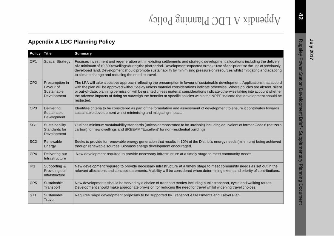
Appendix A LDC Planning Policy
Policy Title Summary
CP1 Spatial Strategy Focuses investment and regeneration within existing settlements and strategic development allocations including the delivery
of a minimum of 10,300 dwellings during the plan period. Development expected to make use of and prioritise the use of previously
developed land. Development should promote sustainability by minimising pressure on resources whilst mitigating and adapting
to climate change and reducing the need to travel.
CP2 Presumption in
Favour of
Sustainable
Development
The LPA will take a positive approach reflecting the presumption in favour of sustainable development. Applications that accord
with the plan will be approved without delay unless material considerations indicate otherwise. Where policies are absent, silent
or out-of-date, planning permission will be granted unless material considerations indicate otherwise taking into account whether
the adverse impacts of doing so outweigh the benefits or specific policies within the NPPF indicate that development should be
restricted.
CP3 Delivering
Sustainable
Development
Identifies criteria to be considered as part of the formulation and assessment of development to ensure it contributes towards
sustainable development whilst minimising and mitigating impacts.
SC1 Sustainability
Standards for
Development
Outlines minimum sustainability standards (unless demonstrated to be unviable) including equivalent of former Code 6 (net zero
carbon) for new dwellings and BREEAM “Excellent” for non-residential buildings
SC2 Renewable
Energy
Seeks to provide for renewable energy generation that results in 10% of the District's energy needs (minimum) being achieved
through renewable sources. Biomass energy development encouraged.
CP4 Delivering our
Infrastructure
New development required to provide necessary infrastructure at a timely stage to meet community needs.
IP1 Supporting &
Providing our
Infrastructure
New development required to provide necessary infrastructure at a timely stage to meet community needs as set out in the
relevant allocations and concept statements. Viability will be considered when determining extent and priority of contributions.
CP5 Sustainable
Transport
New developments should be served by a choice of transport modes including public transport, cycle and walking routes.
Development should make appropriate provision for reducing the need for travel whilst widening travel choices.
ST1 Sustainable
Travel
Requires major development proposals to be supported by Transport Assessments and Travel Plan.
Ju
ly 2
01
7
42
R
ug
ele
y P
ow
er S
tatio
n D
evelo
pm
en
t Brie
f - Su
pple
me
nta
ry P
lan
nin
g D
ocu
me
nt

Policy Title Summary
ST2 Parking
Provision
Appropriate provision for off-street parking to be made in accordance with the maximum parking standards set out in the
Sustainable Design SPD.
CP6 Housing Delivery Established a minimum housing target for the district and includes the strategic allocation to the East of Rugeley for 1,125
dwellings including 500 to meet the needs arising in Rugeley. Residential developments
expected to contribute towards sustainable communities, have high quality design in accordance with relevant SPD, contribute
to meeting housing needs and deliver required infrastructure.
H1 A Balanced
Housing Market
Development to include a mix of house size, type and tenure. Smaller properties including 2-bed apartments and 2 and 3 bed
houses particularly encouraged
H2 Provision of
Affordable
Housing
Targets up to 40% provision with a split of 65% social rent, the remainder a choice or mix of affordable rent or intermediate
housing. Precise amount and mix will be subject to consideration of viability.
CP7 Employment and
Economic
Development
Provides for sufficient employment land to meet identified needs. High value jobs in business, education and research and those
supporting the low carbon economy and key growth sectors are encouraged.
CP8 Our Centres Supports the hierarchy of centres. New Neighbourhood Centres will be required to meet the day to day needs arising from the
new communities proposed as Strategic Development Allocations
CP10 Healthy and Safe
Lifestyles
Facilitated though appropriate provision and access to open spaces and facilities. Infrastructure needs generated by new
developments will be provided in the best way to meet the needs of the new communities. Loss of existing recreational spaces
will be resisted unless alternatives of equivalent or higher standard are provided.
CP11 Participation in
Sport and
Phyiscal Activity
The LPA will seek to encourage, protect and enhance existing sports facilities and assets. Support will be given to proposals
that address existing deficiencies in provision and the creation of new facilities
in areas of unmet demand or the provision of new facilities which accord with the playing pitch strategy. Loss of existing
facilities/assets including playing fields, tennis courts, bowling greens, indoor sports will be resisted unless clearly demonstrated
that alternative facilities of equivalent or better standard are being provided.
HSC1 Open Space
Standards
New SDA to ensure all parts of the development are within 480m/10min of an equipped play area.
Amenity green space to be provided at a minimum rate of 1.43ha/1,000 population.
SDA will provide or contribute to provision of allotments at a rate of 1 plot (150sqm)/32 households where there is evidence of
unmet demand.
Appendix A LDC Planning Policy
Ju
ly 2
01
7
43
R
ug
ele
y P
ow
er S
tatio
n D
evelo
pm
en
t Brie
f - Su
pple
me
nta
ry P
lan
nin
g D
ocu
me
nt

Policy Title Summary
HSC2 Playing Fields
and Sport Facility
Standards
Seeks to prevent the loss or displacement of facilities unless demonstrated alternatives provided of at least an equivalent standard.
Development of new facilities supported in areas of identified unmet need. All new SDA to provide playing field facilities at a
minimum level of 1.23ha/1,000 population including 200m2 for changing and pavilion space and 0.025ha for parking
CP13 Our Natural
Resources
Seeks to safeguard features of ecological and biodiversity interest.
NR3 Biodiversity,
Protected
Species and their
Habitats
Development only permitted where it protects and enhances or suitably mitigates impacts to provide a net biodiversity gain.
NR4 Trees, Woodland
and Hedges
To be protected from damage and retained unless it is demonstrated that removal is necessary and appropriate mitigation is
agreed. Space to be made within development to retain veteran trees and woodlands. Loss of large mature species will be
resisted. Development to be designed to ensure no conflict between retained features and the built form in the longer term. Cross
reference to the Trees, Landscaping and Development SPD.
NR5 Natural and
Historic
Landscapes
Development will be permitted where it does not negatively impact on geological, archaeological and historically important
landscapes.
NR6 Linked Habitat
Corridors and
Multi-functional
greenspaces
Development will be expected to create and link green infrastructure and corridors as part of the multi-functional greenspace
which is integrated into the public realm.
NR7 Cannock Chase
Special Area of
Conservation
Before being permitted, development must show that it does not have an adverse impact on the SAC having regard to avoidance
or mitigation measures. Development resulting in a net increase in
dwellings within a 15knm radius of the SAC is deemed to have an adverse impact unless avoidance or mitigation is provided.
This must, however, be read in conjunction with the most up to date Guidance on SAC mitigation to be found at:
https://www.lichfielddc.gov.uk/Council/Planning/The-local-plan-and-planning-policy/Planning-obligations/Other-mitigation.aspx.
CP14 Our Built and
Historic
Environment
The LPA will protect and improve the built environment. Special regard will be given to the enhancement of the historic environment.
Ju
ly 2
01
7
44
R
ug
ele
y P
ow
er S
tatio
n D
evelo
pm
en
t Brie
f - Su
pple
me
nta
ry P
lan
nin
g D
ocu
me
nt

Policy Title Summary
BE1 High Quality
Development
Developments to achieve high quality sustainable development and have positive impacts on: historic environment, reducing
carbon emissions, built vernacular, safety/crime, amenity, the natural environment and sustainable transport.
Table A.1 LDC Planning Policy
Appendix A LDC Planning Policy
Ju
ly 2
01
7
45
R
ug
ele
y P
ow
er S
tatio
n D
evelo
pm
en
t Brie
f - Su
pple
me
nta
ry P
lan
nin
g D
ocu
me
nt

Appendix B CCDC Planning Policy
Policy Title Summary
CP1 Strategy Focuses investment and regeneration within existing settlements whilst conserving and enhancing the
environment. Presumption in favour of sustainable development. Where there are no policies relevant to an
application or policies are out of date, the Council will grant planning permission unless material considerations
indicate otherwise.
CP2 Presumption in Favour of
Sustainable Development
The LPA will take a positive approach reflecting the presumption in favour of sustainable development.
Applications that accord with the plan will be approved without delay unless material considerations indicate
otherwise. Where policies are absent, silent or out-of-date, planning permission will be granted unless material
considerations indicate otherwise taking into account whether the adverse impacts of doing so outweigh the
benefits or specific policies within the NPPF indicate that development should be restricted.
CP3 Delivering Sustainable
Development
Identifies criteria to be considered as part of the formulation and assessment of development to ensure it
contributes towards sustainable development whilst minimising and mitigating impacts.
CP4 Neighbourhood - Led Planning Sets out the Council support for the neighbourhood plan process
CP5 Social Inclusion and Healthy
Living
Seeks to agree provision, or contributions, towards providing relevant social infrastructure including health,
education, open space plus indoor and outdoor sports/recreation, cultural/community facilities and local
shopping facilities. Standards for the provisions of open space to be set out within supplementary documents.
A presumption against the loss of facilities or green space in line with National Guidance.
CP6 Housing Land Includes recognition of the East of Rugeley allocation in the Lichfield Plan. Advises that release of land for
housing within the district will be managed and the availability of appropriate sites reviewed through the
SHLAA to maintain a 5 year supply.
CP7 Housing Choice Seeks 20% provision affordable housing (subject to viability).
Private housing mix should include mix of tenure and choice of size (Informed by SHMA). The following is
encouraged as part of the mix:
Smaller dwellings for younger people, Housing suitable for those with specific need, Larger 3 and 4 bed
aspirational housing, Housing to cater for an aging population.
CP8 Employment Land Seeks to maintain and deliver a supply of 88ha of new/redeveloped employment land for primarily B use
classes including for 18ha in Rugeley and Brereton.
Ju
ly 2
01
7
46
R
ug
ele
y P
ow
er S
tatio
n D
evelo
pm
en
t Brie
f - Su
pple
me
nta
ry P
lan
nin
g D
ocu
me
nt

Policy Title Summary
Redevelopment of existing employment /brownfield sites for employment uses will be encouraged and
supported.
CP9 A Balanced Economy Priority given to employment uses which add value and raise job density. Proposals for low density job
generation jobs (eg B8 uses) will need to demonstrate their added value to the economy.
CP10 Sustainable Transport Development to promote sustainable travel. Need for Transport Assessments and Travel Plans. Measures
to promote walking and cycling should be incorporated into new development including segregated cycleways
(developments over 200 dwellings). Local parking standards to be developed through Local Plan Part 2.
CP11 Centres Hierarchy Establishes a hierarchy of centres. New housing development should enhance existing centres or provide
new local centre as appropriate.
CP12 Biodiversity and Geodiversity Seeks to conserve and enhance ecological and geological sites/ species. Development will not be permitted
if harm cannot be mitigated.
CP13 Cannock Chase SAC Developments leading to net increase in dwellings will be required to mitigate adverse effects on the SAC
though contributions, provision of Suitable Alternative Natural Green spaces (SANG) within developments
(on or off site) and measures to encourage sustainable travel. However, the position on this has now been
updated and the policy must therefore be read in conjunction with the most up to date Guidance on SAC
mitigation to be found at http://www.cannockchasedc.gov.uk/sites/
default/files/cannock_cannock_chase_sac_updated_guidance_january_2017.pdf
CP14 Landscape Character and
Cannock Chase AONB
Developments should take account of landscape character and maximise opportunities for restoring,
strengthening and enhancing distinctive landscape features.
Appendix B CCDC Planning Policy
Ju
ly 2
01
7
47
R
ug
ele
y P
ow
er S
tatio
n D
evelo
pm
en
t Brie
f - Su
pple
me
nta
ry P
lan
nin
g D
ocu
me
nt

Policy Title Summary
CP16 Climate Change and
Sustainable Resource Use
Encourage and support proposals for energy efficiency, use of renewable, low carbon energy generation
and sustainable construction; reduce pollution; minimise waste and sustainable use of land (preference for
brownfield development). Development should take account of flood risk.
New developments should:
Explore measures to exceed national targets for zero-carbon development and sustainable construction
Assess how they can include renewable and low carbon technologies
Achieve water efficiency of 105 litres/person/day (former Code 3/4)
Non-residential development should seek to achieve BREEAM “Very good” as a minimum
Improve energy efficiency over and above building regulations
Use SuDS
Table B.1 CCDC Planning Policy
Ju
ly 2
01
7
48
R
ug
ele
y P
ow
er S
tatio
n D
evelo
pm
en
t Brie
f - Su
pple
me
nta
ry P
lan
nin
g D
ocu
me
nt