Rudgwick Walks 2 - · PDF fileRudgwick Walks 2 Forgotten Villages of the Surrey-Sussex Border...
8
Rudgwick Walks 2 Forgotten Villages of the Surrey-Sussex Border Onslow Arms to Sydney Farm and Ifold Access Park behind Onslow Arms in Wey and Arun Canal car park. Alternatively, park in Ifold, and begin the walk from there (no specific parking area). Pub info @ 01403 752452. Length and suitability 4¾ miles (8 km), 2 hours 30 minutes. Take great care both crossing the B2133 (High Street, Loxwood) and also where the pavement is narrow. The walk is on vehicular roads in Ifold, otherwise off- road, on green lanes, through fields and along canal towpath. NB, near the end of the walk, a temporary footpath diversion may be in operation at Devils Hole (see map, page 12) for canal reconstruction, whilst work is in progress. 1. From the car park, walk behind the Onslow Arms onto the towpath. Turn right up High Street. The pub garden, next to the river bridge, is the site of a tollhouse for the turnpike road operating through Loxwood 1757-1876. It was demolished in the 1960s. The start of this walk is one of great interest as the new lock and bridge over the canal to allow it to cross under the B2133 take shape. This is a major step towards realising the dream of the Wey and Arun Canal Trust to open the canal. Take the opportunity to ask anyone working here about the current works. See page 17 and 59 for details of canal and restoration. On Loxwood High Street, notice, in quick succession: • former canal warehouse/offices, now a joiner’s shop (Clifton’s), left • the former ‘dame school’ building opposite, just before Gartons, right • the wooden studio, built for pre-war local photographer Harry Sopp, left • steps to the former butcher’s opposite (also Sopp family), and its stables • the attractive group of listed buildings as you walk up the hill, right • Old Stores, formerly Hilltop Stores, with its old petrol pump, right (shop and adjoining cottages owned by my grandparents, JA and MI Harris c1910-46) • Site of moated Loxwood Place, left, burnt down c1949; notice listed granary • Willetts & Chapel Cottage also listed (Chapel demolished c1900), right • Station Road (to Rudgwick Station!), right • Pond in front of old bakehouse, once belonged to the Dependants (or ‘Cokelers’) who had a ‘Combination Stores’ and bakery, now modern shops.
-
Upload
nguyenmien -
Category
Documents
-
view
215 -
download
0
Transcript of Rudgwick Walks 2 - · PDF fileRudgwick Walks 2 Forgotten Villages of the Surrey-Sussex Border...
Rudgwick Walks 2
Forgotten Villages of the Surrey-Sussex Border
Onslow Arms to Sydney Farm and Ifold Access Park behind Onslow Arms in Wey and Arun Canal car park.
Alternatively, park in Ifold, and begin the walk from there (no specific parking
area). Pub info @ 01403 752452.
Length and suitability 4¾ miles (8 km), 2 hours 30 minutes.
Take great care both crossing the B2133 (High Street, Loxwood) and also where
the pavement is narrow. The walk is on vehicular roads in Ifold, otherwise off-
road, on green lanes, through fields and along canal towpath.
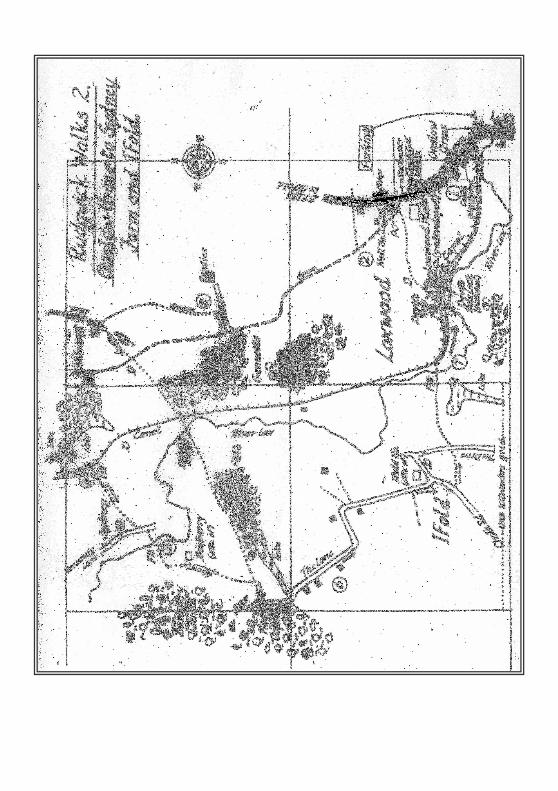
NB, near the end of the walk, a temporary footpath diversion may be in operation at Devils Hole
(see map, page 12) for canal reconstruction, whilst work is in progress.
1. From the car park, walk behind the Onslow Arms onto the towpath. Turn right up High Street.
The pub garden, next to the river bridge, is the site of a tollhouse for the turnpike road
operating through Loxwood 1757-1876. It was demolished in the 1960s.
The start of this walk is one of great interest as the new lock and bridge over
the canal to allow it to cross under the B2133 take shape. This is a major step towards
realising the dream of the Wey and Arun Canal Trust to open the canal. Take the
opportunity to ask anyone working here about the current works. See page 17 and 59
for details of canal and restoration.
On Loxwood High Street, notice, in quick succession:
• former canal warehouse/offices, now a joiner’s shop (Clifton’s), left
• the former ‘dame school’ building opposite, just before Gartons, right
• the wooden studio, built for pre-war local photographer Harry Sopp, left
• steps to the former butcher’s opposite (also Sopp family), and its stables
• the attractive group of listed buildings as you walk up the hill, right
• Old Stores, formerly Hilltop Stores, with its old petrol pump, right (shop and
adjoining cottages owned by my grandparents, JA and MI Harris c1910-46)
• Site of moated Loxwood Place, left, burnt down c1949; notice listed granary
• Willetts & Chapel Cottage also listed (Chapel demolished c1900), right
• Station Road (to Rudgwick Station!), right
• Pond in front of old bakehouse, once belonged to the Dependants (or
‘Cokelers’) who had a ‘Combination Stores’ and bakery, now modern shops.
2. At junction of Station Road, cross road to PO/shop, follow track ahead, left of shop. Turn right behind shop onto green lane, continue for 0.4 mile.
[later, footpath on OS map deviates from green lane. Ignore - follow signed path]
On joining a tarmac private road (to Gennets, on left) turn right, go a short distance on the unfenced road across a field.
3. Then, turn left along the hedge in the same field (do NOT continue to Pawlies!). NB path may be overgrown in Summer. Near the end of the field, veer right through bracken and a dry ditch into the next field, then left (no change of direction). Find a stile in the left corner of this field, continuing ahead towards Oakhurst Farm, through a field gate into the farmyard by a pond. Please leave all gates as found.
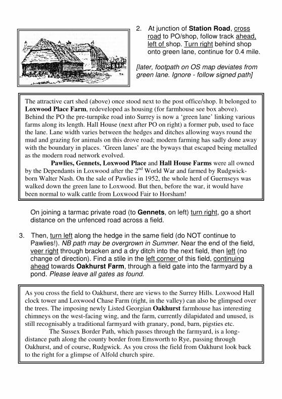
The attractive cart shed (above) once stood next to the post office/shop. It belonged to
Loxwood Place Farm, redeveloped as housing (for farmhouse see box above).
Behind the PO the pre-turnpike road into Surrey is now a ‘green lane’ linking various
farms along its length. Hall House (next after PO on right) a former pub, used to face
the lane. Lane width varies between the hedges and ditches allowing ways round the
mud and grazing for animals on this drove road; modern farming has sadly done away
with the boundary in places. ‘Green lanes’ are the byways that escaped being metalled
as the modern road network evolved.
Pawlies, Gennets, Loxwood Place and Hall House Farms were all owned
by the Dependants in Loxwood after the 2nd
World War and farmed by Rudgwick-
born Walter Nash. On the sale of Pawlies in 1952, the whole herd of Guernseys was
walked down the green lane to Loxwood. But then, before the war, it would have
been normal to walk cattle from Loxwood Fair to Horsham!
As you cross the field to Oakhurst, there are views to the Surrey Hills. Loxwood Hall
clock tower and Loxwood Chase Farm (right, in the valley) can also be glimpsed over
the trees. The imposing newly Listed Georgian Oakhurst farmhouse has interesting
chimneys on the west-facing wing, and the farm, currently dilapidated and unused, is
still recognisably a traditional farmyard with granary, pond, barn, pigsties etc.
The Sussex Border Path, which passes through the farmyard, is a long-
distance path along the county border from Emsworth to Rye, passing through
Oakhurst, and of course, Rudgwick. As you cross the field from Oakhurst look back
to the right for a glimpse of Alfold church spire.
Turn left into the farmyard, leave by a field gate, briefly on the Sussex Border Path, go ahead keeping to the right of a field to another gate. Immediately, at cross roads of paths, turn right through a further gate to rejoin the green lane.
Diversion: for a shortcut, do not go through the last of these gates. Continue on the Sussex Border Path, ahead, crossing the canal at Gennets Bridge and Lock, then crossing the River Lox at Barberry Bridge, follow another green lane through attractive woodland to meet The Lane to Ifold (at 6 below).
Having turned right, keep close to the hedgerow, through a field to pretty Oakhurst Cottage ahead, keeping to the right of cottage. Then (leaving the green lane which continues ahead) turn left, alongside the cottage passing the rear gate. Follow signs (right, right, then left) on a winding path through Gennets Wood, skirting the small muddy pond to your left (take care as other paths join) leading to the bank of a lake.
Keep right along the lake bank until you come to a left turn across a gated dam between two lakes, which will take you into a field. Go ahead (slightly right) a short distance and up a slope, where you will see a sturdy wooden bridge, with one stile, over the Wey and Arun Canal which you cross. Turn left on towpath.
4. Shortly, at a footpath sign, turn right over two stiles. Go ahead through two
fields, divided by a farm track and two further stiles, to Sydney Farm, keeping close to the hedgerow in both fields.
Diversion: another shortcut - stay on the towpath, passing Southlands (known to the canal folk as Turnkey House), and nearby Southlands Lock soon to be rebuilt, all the way back to the Onslow Arms, rejoining this walk at
7.
Enter Sydney Farm, over an old stile, passing in front of stables and a farm cottage, through a new field gate, then turn left (avoiding turning right into Rosemary Lane!) passing the sign to Old Manor House. Before you get to the gate of the house, turn right, over a stile, into a steep field. Cross the field to a gap ahead in bushes.
The Wey & Arun Canal bed was last cleared here in 2000 and the footbridge built in
2002. This part is contained in a pound between temporary dams. There was a lock to
the right of the footbridge.
The two recently created private lakes belonging to Upper Oakhurst were dammed
for fishing, and contain sizeable carp. The northern one seems the more attractively
landscaped (possibly older) of the two. Crossing the dam you briefly enter Surrey.
5. Cross the River Lox by a footbridge, with a stile each end (one not dog-friendly). Cross another small field and a second footbridge ahead over a ditch (one stile). Then, go across a bigger field, half left, uphill to a gateway, half way up the hedgerow.
Turn left through gateway to cross the next field to another gap, then pass scrubby land with trees on your left (site of Barberry Farm, of which only the fenced well remains), and pigs on your right. Go straight ahead, keeping pig enclosures on your right. As the path enters woodland you meet a new fence. Turn sharp right along this fence joining the Sussex Border Path (diverted in 2006 to avoid going through the garden of Forest View, a bungalow with large grounds). At the lane turn left, passing this bungalow. Do NOT turn right into Hog Copse and Hogwood, a large forest!
6. Now continue ahead along The Lane towards Ifold, making sure you turn half left in trees before the first junction (to avoid taking a gated Forestry Commission track, leading to Hogwood Farm). Follow the signed bridleway through the trees cutting off the right angle to rejoin The Lane almost immediately.Pass several scattered properties, following the road round a sharp left, then sharp right to enter Ifold proper, 0.6 mile from the first bungalow (Forest View, above).
Read the box on the next page before going too far into Ifold. Ifold is an alternative parking and starting point.
Sydney Farm, in Alfold is a remote location at the end of Rosemary Lane on a spur
overlooking a river valley – the infant River Lox, which is an Arun tributary that
passes the Onslow Arms downstream. There is an C18th
granary and an historically
important house. Sydney, Australia, was named after Thomas Townshend, 1
st Viscount
Sydney, 1733-1800. He took this title from his maternal line descending from a C16th
Earl of Leicester, himself descended from John de Sydenie, a yeoman farmer of
Alfold in the reign of Edward I, and thought to have lived in Sydney farmhouse,
hence linking this property to Sydney, Australia. Later, in 1447, William Sydney of
Alfold bought Baynards, creating a park extending from Cranleigh to Rudgwick. Townshend was never in Australia – he was the Home Secretary to William
Pitt, and sent the first convicts to Botany Bay. His appointee as first governor, Arthur
Phillip, named Sydney Cove, later Sydney Town, in Townshend’s honour in 1788. On regaining the higher ground, a patch of rough woodland and a pond
marks where there was once a house called Barberry. At the time of writing, there
are organic outdoor-reared pigs and chicken. If the pigs are not sleeping or mud
bathing they may come up to the fence.
At the next junction of roads, at the dilapidated Curtis’s Garage, go straight ahead, but then turn half right into Chalk Road for a short way. Don’t miss a signed path on your left, between gardens, to cut through to The Ride.
Cross The Ride, and go ahead on a path that begins as a gravel driveway, keeping to the left of a garden and garage, follow a fenced path out of Ifold. Go ahead, to the bridge over the Lox.
Ifold Estate still evokes images of its pre-war break-up into ‘plotlands’ on which the
new owner, usually a Londoner, could build a small wood or brick dwelling, or even
a railway carriage, to retreat from the city at weekends, later to live and raise a family.
Many owners were able to escape the troubles in London during wartime away-
weekends by coach.
The plots you saw first were bigger smallholdings, whereas the main triangle
of roads had smaller garden plots. Few houses resemble the originals. Recent
commuting owners have invested in ever-larger houses, or sold infill plots. Spot an
early bungalow on the right of The Lane.
Ifold House itself was demolished in 1936. Look for the The Old Garden, a
bungalow which incorporates some of the old garden buildings, and the walled
garden itself in the garden of Clovers End, two houses along. The Garage (once an
essential service for the plotholders) is opposite, next to one of the old estate houses,
being renovated. Many mature estate trees have also survived.
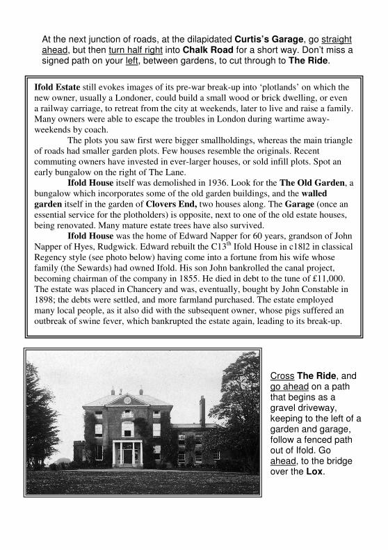
Ifold House was the home of Edward Napper for 60 years, grandson of John
Napper of Hyes, Rudgwick. Edward rebuilt the C13th
Ifold House in c18l2 in classical
Regency style (see photo below) having come into a fortune from his wife whose
family (the Sewards) had owned Ifold. His son John bankrolled the canal project,
becoming chairman of the company in 1855. He died in debt to the tune of £11,000.
The estate was placed in Chancery and was, eventually, bought by John Constable in
1898; the debts were settled, and more farmland purchased. The estate employed
many local people, as it also did with the subsequent owner, whose pigs suffered an
outbreak of swine fever, which bankrupted the estate again, leading to its break-up.
7. Cross the river and go half left across a rough meadow to meet the canal towpath. Turn half-right onto the canal towpath. Follow the canal past Devil’s Hole Lock and bridge. Continue all the way to main road (0.6 mile). Take care crossing the road on the bend to Onslow Arms (until the pedestrian route under the road opens, when the canal road crossing is completed).
Donations to the Wey & Arun Canal Trust for this entirely voluntary project are always welcomed. The June ‘Poddle’ raises over £10,000 annually from a popular sponsored walk, and will appeal to users of this booklet. This approximately 15 mile walk starts from a different location in Sussex or Surrey every year. See the website listed on page 57 for a history of the canal and the latest news of the project and poddle.
Loxwoodhills Pond (work that name out!) is on your right, and once was part of the
landscaped grounds of Ifold. The River Lox is now a little bigger than at Sydney
Farm. This path, much used by the original Ifolders, led to the village shops in
Loxwood.
Do not touch the giant hogweed that blights the meadow here. This invader
of the countryside has arrived in England recently, grows to 15 feet or more, and is a
public health hazard.
The unprofitable canal closed in the
1860s. Canal clearance first began here
in 1997. Devil’s Hole is an old river
oxbow and cliff, cut off by canal
construction in 1813-16, giving its
name to the lock built here. Canadian
sappers blew up this lock in practice
exercises for the Dieppe Raid. The
bridge was rebuilt in 1983, the lock in
2004, and gates will follow when the
road crossing is complete.
Work began on the road
crossing in July 2005. You pass the new
2006 lock and bridge on your route. At
the road, the canal has been lowered
(also Brewhurst Lock beyond) and
under-road services moved ready for the
brickwork to line the canal tunnel under
the road, whose level remains
unchanged.
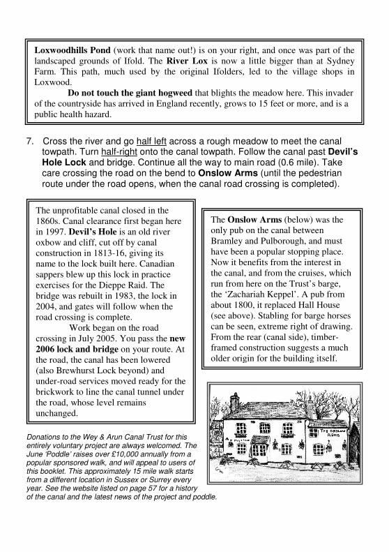
The Onslow Arms (below) was the
only pub on the canal between
Bramley and Pulborough, and must
have been a popular stopping place.
Now it benefits from the interest in
the canal, and from the cruises, which
run from here on the Trust’s barge,
the ‘Zachariah Keppel’. A pub from
about 1800, it replaced Hall House
(see above). Stabling for barge horses
can be seen, extreme right of drawing.
From the rear (canal side), timber-
framed construction suggests a much
older origin for the building itself.