Rubicon Camping Areas - Forest Fire Management Victoria · Rubicon Camping Areas FS0067 . rocky in...
3
Rubicon Camping Areas DELWP– Alexandra February 2015 FS0067 ISSN 1440-2262 Rubicon Camping Areas The Rubicon Valley Historic Area, in the Rubicon State Forest is about 2 hours drive north east of Melbourne. It provides excellent opportunities for camping, bushwalking, picnicking, fishing and mountain biking. Location and access From the Maroondah Highway, turn right onto the Taggerty- Thornton Rd and right again onto Rubicon Rd. Kendalls Camp is approximately 5.5 km along Rubicon Rd. The camping areas are accessible by 2WD. Kendalls and Tin Hut are closed from the Thursday after the Queen’s Birthday holiday through to the Thursday before Melbourne Cup. The Boys is open all year. History The Rubicon area is Taungurung land. The Taungurung people continue to have a strong connection with the area through Camp Jungai. The surrounding forest is an important catchment area for the hydro-electric power stations situated at various locations along the Rubicon Valley. Completed in 1929, the Rubicon Scheme consists of four power stations and associated dams, aqueducts and pipelines. During the 1930’s, the scheme contributed about one-fifth of Victoria’s electricity needs. While still in operation today, its contribution to meeting the State’s energy needs is now small, however it’s relative importance is still high due to its contribution to green power. The Rubicon State Forest has a long history of timber production. Prior to the 1939 fires, there were many sawmills and settlements utlilising the productive forests. The Royal Commission following the 1939 fires recommended removing all sawmills and settlements from the forest. The area continues to be an important area for hardwood timber production. The current industry prizes the timber produced from Mountain Ash, Alpine Ash and Shining Gum which dominate forests higher on the ranges. There are three camping areas located on the valley floor along the Rubicon River – Kendalls, The Boys and Tin Hut. The Boys was the location of the single men’s camp after WW1, while Tin Hut was the location of Tin Hut township that serviced the hdyro-electric scheme and timber workers in the first half of the 20 th century. What facilities are provided? Pit toilets are provided at Kendalls and The Boys. Kendalls has open areas suitable for small caravans. A short picturesque walking track connects Kendalls and The Boys campgrounds. A longer circuit walk also begins from The Boys Camp. Things to see and do Rubicon Valley Historic Area and the surrounding forest provides excellent opportunities for fishing, camping, mountain bike riding, bushwalking, horse riding and canoeing. Kendalls Link Trail Kendalls Link Trail is a short 1.1 km walk that connects Kendalls Camp to the Boys Camp. This flat, well formed track is a great short stroll through the riparian bush. Cicada Circuit Trail Starting at The Boys Camp, this 6.1 km return loop takes in both sides of the Rubicon River. The trail meanders along the river for a large part of the walk which is perfect for taking in the sounds of the river, the birds and the rustling trees. Cross the bridge over the pipeline and follow the road towards Camp Jungai and back onto the trail. The remainder of the trail passes through the bush above the campgrounds before ending back at The Boys Camp. Additional attractions in the area are detailed in a separate Forests Note (Rubicon State Forest FS0055) and include: • Snobs Creek Falls These falls drop more than 100 metres over a series of rocky outcrops and offer spectacular views. There is a short walk from the carpark to viewing platforms. • Morris Lookout Morris Lookout is a short drive (4WD only) from the camping areas and provides stunning views of the surrounding area, including the townships of Thornton and Eildon. Access to the lookout is via Herbs Rd. This road is closed during the winter months (see Seasonal Road Closures below for more information). • Mt Torbreck summit Mt Torbreck, rising to an altitude of 1516 m, is a 2 km walk (one-way) from the Barnewall Plains visitor area on Barnewall Plains Rd. The walk takes approximately 2 hours return, and is steep and © State of Victoria, Department of Environment, Land, Water & Planning Page 1
Transcript of Rubicon Camping Areas - Forest Fire Management Victoria · Rubicon Camping Areas FS0067 . rocky in...
Rubicon Camping Areas DELWP– Alexandra
February 2015 FS0067
ISSN 1440-2262
Rubicon Camping Areas The Rubicon Valley Historic Area, in the Rubicon State Forest is about 2 hours drive north east of Melbourne. It provides excellent opportunities for camping, bushwalking, picnicking, fishing and mountain biking.
Location and access From the Maroondah Highway, turn right onto the Taggerty-Thornton Rd and right again onto Rubicon Rd. Kendalls Camp is approximately 5.5 km along Rubicon Rd. The camping areas are accessible by 2WD. Kendalls and Tin Hut are closed from the Thursday after the Queen’s Birthday holiday through to the Thursday before Melbourne Cup. The Boys is open all year.
History The Rubicon area is Taungurung land. The Taungurung people continue to have a strong connection with the area through Camp Jungai.
The surrounding forest is an important catchment area for the hydro-electric power stations situated at various locations along the Rubicon Valley. Completed in 1929, the Rubicon Scheme consists of four power stations and associated dams, aqueducts and pipelines. During the 1930’s, the scheme contributed about one-fifth of Victoria’s electricity needs. While still in operation today, its contribution to meeting the State’s energy needs is now small, however it’s relative importance is still high due to its contribution to green power.
The Rubicon State Forest has a long history of timber production. Prior to the 1939 fires, there were many sawmills and settlements utlilising the productive forests. The Royal Commission following the 1939 fires recommended removing all sawmills and settlements from the forest.
The area continues to be an important area for hardwood timber production. The current industry prizes the timber produced from Mountain Ash, Alpine Ash and Shining Gum which dominate forests higher on the ranges.
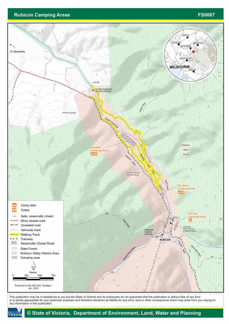
There are three camping areas located on the valley floor along the Rubicon River – Kendalls, The Boys and Tin Hut. The Boys was the location of the single men’s camp after WW1, while Tin Hut was the location of Tin Hut township that serviced the hdyro-electric scheme and timber workers in the first half of the 20th century.
What facilities are provided? Pit toilets are provided at Kendalls and The Boys.
Kendalls has open areas suitable for small caravans. A short picturesque walking track connects Kendalls and The Boys campgrounds. A longer circuit walk also begins from The Boys Camp.
Things to see and do Rubicon Valley Historic Area and the surrounding forest provides excellent opportunities for fishing, camping, mountain bike riding, bushwalking, horse riding and canoeing.
Kendalls Link Trail
Kendalls Link Trail is a short 1.1 km walk that connects Kendalls Camp to the Boys Camp.
This flat, well formed track is a great short stroll through the riparian bush.
Cicada Circuit Trail
Starting at The Boys Camp, this 6.1 km return loop takes in both sides of the Rubicon River.
The trail meanders along the river for a large part of the walk which is perfect for taking in the sounds of the river, the birds and the rustling trees. Cross the bridge over the pipeline and follow the road towards Camp Jungai and back onto the trail. The remainder of the trail passes through the bush above the campgrounds before ending back at The Boys Camp.
Additional attractions in the area are detailed in a separate Forests Note (Rubicon State Forest FS0055) and include:
• Snobs Creek Falls These falls drop more than 100 metres over a series of rocky outcrops and offer spectacular views. There is a short walk from the carpark to viewing platforms.
• Morris Lookout Morris Lookout is a short drive (4WD only) from the camping areas and provides stunning views of the surrounding area, including the townships of Thornton and Eildon. Access to the lookout is via Herbs Rd. This road is closed during the winter months (see Seasonal Road Closures below for more information).
• Mt Torbreck summit Mt Torbreck, rising to an altitude of 1516 m, is a 2 km walk (one-way) from the Barnewall Plains visitor area on Barnewall Plains Rd. The walk takes approximately 2 hours return, and is steep and
© State of Victoria, Department of Environment, Land, Water & Planning Page 1
Rubicon Camping Areas FS0067
rocky in sections. On a clear day, views from around the summit are breathtaking and well worth the long climb.
Lake Eildon National Park
Situated on the shores of Lake Eildon, the Park protects 27,750 ha of rugged hills with open
woodlands through to dense forest. It is very scenic, and offers the opportunity to experience an array of wildlife, natural and historic features and a wide range of recreational activities.
Campfire Guidelines • Campfire safety – All solid fuel fires must be in a
properly constructed fireplace or in a trench at least 30 cm deep, with the ground and airspace within 3m of the outer perimeter of the fire clear of flammable material. All liquid, gas or chemical solid fuel fires must keep the ground and airspace within 1.5m of the outer perimeter of the fire clear of flammable material. Fires must be attended at all times by a person with the capacity and means to extinguish it. Ensure the fire is extinguished with water before leaving. If it’s cool to touch it is safe to leave.
• Campfires are prohibited on days of Total Fire Ban. This ban does not apply to a person preparing meals on a gas or electric appliance that has been designed and commercially manufactured exclusively for cooking provided: - the ground and airspace within 3m of the appliance
is clear of flammable material - when in use and alight, the appliance at all times is
in a stable position and attended by an adult who has the capacity and means (minimum of 10 litres of water on hand) to extinguish the fire.
It is your responsibility to know if a Total Fire Ban is declared. If in doubt, do not light a campfire.
Forest Use Guidelines
CAMPING – Minimal impact
To protect the delicate environments of the forest, we need to ‘tread lightly’ in the bush to minimise our impact on the natural environment. • Camping is not permitted outside of designated areas
or within 20 metres of any river, stream or lake. • Be careful of camping under trees. Trees can drop
their limbs at any time (particularly during high winds). • Do not dig trenches around tents. With modern tents,
this is unnecessary, particularly if you choose a well-drained or raised site.
• Use toilets where provided. At some sites hand washing facilities and toilet paper may not be supplied. Come prepared.
• All native plants and animals are protected. • Dogs are allowed in State Forest but must be under
direct control at all times and are expected to be on a leash in picnic and camping areas or when near other visitors.
• Protect water quality – wash up at least 50 metres away from the river and avoid using soap (use gritty sand and a scourer instead).
• Leave campsites tidy.
RUBBISH
There are no rubbish collection facilities available. Please take your rubbish with you and ensure the area is clean for future visitors. Do not bury or burn rubbish in fires. This includes bottles and cans. It is an offence to burn rubbish and those doing so will be fined.
TRAIL BIKES and VEHICLES
Trail bikes and vehicles must be registered. Unlicensed persons are not permitted to ride trail bikes or drive vehicles. Trail bikes and vehicles must not be ridden off formed roads, on walking tracks or around the campground. The surrounding road network is available to licenced and registered riders.
FIREARMS
Normal firearm laws apply in State Forests. • A licence is required • It is prohibited to shoot on, from or across roads • Use of firearms in camping areas is prohibited.
All native birds and animals are protected by law. Rubicon Valley Historic Area is a popular recreation area. Take special care with firearms.
Safety – Please read • On Code Red Fire Danger Rating days, Parks and
State forest are closed to the public. Do not enter parks or forests on Code Red Days. If you are already there when a Code Red day is announced, you should leave the night before or early in the morning. For more information contact DELWP (see below).
• When on forest roads, be prepared for the unexpected. Timber trucks, 4WD’s, hikers, horse riders, trail bike riders, cyclists and native animals may also be using your chosen track.
Seasonal Road Closures Some roads within the forest are seasonally closed each year from the Thursday after the Queen’s Birthday holiday through to the Thursday before Melbourne Cup. This is to protect track surfaces and the environment, and for public safety. Road closures may be extended beyond these dates, depending on weather conditions. These closures are enforced by a gate or sign. Contact DELWP for more information on road closures.
For more information
The Department of Environment, Land, Water & Planning (DELWP) is responsible for managing Victoria's State Forest. For further information contact DELWP's Customer Service Centre 136 186 (TTY: 1800 555 667) or visit DELWP’s website at http://www.delwp.vic.gov.au
This publication may be of assistance to you but the State of Victoria and its officers do not guarantee that the publication is without flaw of any kind or is wholly appropriate for your particular purposes and therefore disclaims all liability for any error, loss or other consequence which may arise from you relying on any information in this publication.
© State of Victoria, Department of Environment, Land, Water & Planning Page 2
!
!
!
!
!
!
!
!
!
!
!
!
!
!
!
!
!
!
!
!
!
!
!
!
!
!
!
!
!
!
!
!
!
!
!
!
!
!
!
!
!
!
!
!
!
!
!
!
!
!
!
!
!
!
!
!
!
!
!
!
!
!
!
!
!
!
!
!
!
!
!
!
!
!
!
!
!
!
!
!
!
!
!
!
!
!
!
!
!
!
!
!
!
!
!
!
!
!
!
!
!
!
!
!
!
!
!
!
!
!
!
!
!
!
!
!
!
!
!
!
!
!
!
!
!
!
!
!
!
!
!
!
!
!
!
!
!
!
!
!
!
!
!
!
!
!
!
!
!
!
!
!
!
!
!
!
!
!
!
!
!
!
!
!
!
!
!
!
!
!
!
!
!
!
!
!
!
!
!
!
!
!
!
!
!
!
!
!
!
!
!
!
!
!
!
!
!
!
!
!
!
!
!
!
!
!
!
!
!
!
!
!
!
!
!
!
!
!
!
!
!
!
!
!
!
!
!
!
!
!
!
!
!
!
!
!
!
!
!
!
!
!
!
!
!
!
!
!
!
!
!
!
!
!
!
!
!
!
!
!
!
!
!
!
!
!
!
!
!
!
!
!
!
!
!
!
!
!
!
!
!
!
!
!
!
!
!
!
!
!
!
!
!
!
!
!
!
!
!
!
!
!
!
!
!
!
!
!
!
!
!
!
!
!
!
!
!
!
!
!
!
!
!
!
!
!
!
!
!
!
!
!
!
!
!
!
!
!
!
!
!
!
!
!
!
!
!
!
!
!
!
!
!
!
!
!
!
!
!
!
!
!
!
!
!
!
!
!
!
!
!
!
!
!
!
!
!
!
!
!
!
!
!
!
!
!
!
!
!
!
!
!
!
!
!
!
!
!
!
!
!
!
!
!
!
!
!
!
!
!
!
!
!
!
!
!
!
!
!
!
!
!
!
!
!
!
!
!
!
!
!
!
!
!
!
!
!
!
!
!
!
!
!
!
!
!
!
!
!
!
!
!
!
!
!
!
!
!
!
!
!
!
!
!
!
!
!
!
!
!
!
!
!
!
!
!
!
!
!
!
!
!
!
!
!
!
!
!
!
!
!
!
!
!
!
!
!
!
!
!
!
!
!
!
!
!
!
!
!
!
!
!
!
!
!
!
!
!
!
!
!
!
!
!
!
!
!
!
!
!
!
!
!
!
!
!
!
!
!
!
!
!
!
!
!
!
!
!
!
!
!
!
!
!
!
!
!
!
!
!
!
!
!
!
!
!
!
!
!
!
!
!
!
!
!
!
!
!
!
!
!
!
!
!
!
!
!
!
!
!
!
!
!
!
!
!
!
!
!
!
!
!
!
!
!
!
!
!
!
!
!
!
!
!
!
!
!
!
!
!
!
!
!
!
!
!
!
!
!
!
!
!
!
!
!
!
!
!
!
!
!
!
!
!
!
!
!
!
!
!
!
!
!
!
!
!
!
!
!
!
!
!
!
!
!
!
!
!
!
!
!
!
!
!
!
!
!
!
!
!
!
!
!
!
!
!
!
!
!
!
!
!
!
!
!
!
!
!
!
!
!
!
!
!
!
!
!
!
!
!
!
!
!
!
!
!
!
!
!
!
!
!
!
!
!
!
!
!
!
!
!
!
!
!
!
!
!
!
!
!
!
!
!
!
!
!
!
!
!
!
!
!
!
!
!
!
!
!
!
!
!
!
!
!
!
!
!
!
!
!
!
!
!
!
!
!
!
!
!
!
!
!
!
!
!
!
!
!
!
!
!
!
!
!
!
!
!
!
!
!
!
!
!
!
!
!
!
!
!
!
!
!
!
!
!
!
!
!
!
!
!
!
!
!
!
!
!
!
!
!
!
!
!
!
!
!
!
!
!
!
!
!
!
!
!
!
!
!
!
!
!
!
!
!
!
!
!
!
!
!
!
!
!
!
!
!
!
!
!
!
!
!
!
!
!
!
!
!
!
!
!
!
!
!
!
!
!
!
!
!
!
!
!
!
!
!
!
!
!
!
!
!
!
!
!
!
!
!
!
!
!
!
!
!
!
!
!
!
!
!
!
!
!
!
!
!
!
!
!
!
!
!
!
!
!
!
!
!
!
!
!
!
!
!
!
!
!
!
!
!
!
!
!
!
!
!
!
!
!
!
!
!
!
!
!
!
!
!
!
!
!
!
!
!
!
!
!
!
!
!
!
!
!
!
!
!
!
!
!
!
!
!
!
!
!
!
!
!
!
!
!
!
!
!
!
!
!
!
!
!
!
!
!
!
!
!
!
!
!
!
!
!
!
!
!
!
!
!
!
!
!
!
!
!
!
!
!
!
!
!
!
!
!
!
!
!
!
!
!
!
!
!
!
!
!
!
!
!
!
!
!
!
!
!
!
!
!
!
!
!
!
!
!
!
!
!
!
!
!
!
!
!
!
!
!
!
!
!
!
!
!
!
!
!
!
!
!
!
!
!
!
!
!
!
!
!
!
!
!
!
!
!
!
!
!
!
!
!
!
!
!
!
!
!
!
!
!
!
!
!
!
!
!
!
!
!
!
!
!
!
!
!
!
!
!
!
!
!
!
!
!
!
!
!
!
!
!
!
!
!
!
!
!
!
!
!
!
!
!
!
!
!
!
!
!
!
!
!
!
!
!
!
!
!
!
!
!
!
!
!
!
!
!
!
!
!
!
!
!
!
!
!
!
!
!
!
!
!
!
!
!
!
!
!
!
!
!
!
!
!
!
!
!
!
!
!
!
!
!
!
!
!
!
!
!
!
!
!
!
!
!
!
!
!
!
!
!
!
!
!
!
!
!
!!
!
!
!
!
!
!
!
!
!
!
!
!
!
!
!
!
!
!
!
!
!
!
!
!
!
!
!
!
!
!
!
!
!
!
!
!
!
!
!
!
!
!
!
!
!
!
!
!
!
!
!
!
!
!
!
!
!
!
!
!
!
!
!
!
!
!
!
!
!
!
!
!
!
!
!
!
!
!
!
!
!
!
!
!
c
"
"
e
RubiconRoad
Cicada Circuit Trail
Herbs
Track
Herbs Tr ack
KendallsCamping Area
LOWER RUBICONPOWER STATION
Rubicon ValleyHistoric Area
Rubicon State Forest
RUBICON
M@
Private property
JUNGAI
KendallsLink
Trail
RUBICONPOWERSTATION !
!
The BoysCamping AreaM@
Tin HutCamping AreaM
ROYSTON RIVER
RoystonRoad
HISTORICPOST OFFICE(Private Property)
Parks Road
Rubic
onRiv
er Road
c
Snobs No6 Track
e
e
520
440
720
920
820
760
460
600
680
280
320
560
780
740
620
800
700
640
900
260
680
640
660780
680
660
680
720
580
760
640
300
1000
540
700
620
880
540
700
600
720
500
700
600
580
740
560
680
620
760
980
660
1060
1040
480
640
860
1020
620
960
1000
980
840
860
600
960
820
580
560
580
540
800
300
620
780
760
740
400
720680
940
360
920
380
900
880
660
840
640
820
280
800
600
740
720700
660
560
580
560
420
520
500
440
520
500
460
320
480
340
S.C.
S.C.
S.C.
S.C.
S.C.
S.C.
S.C.
S.C.
This publication may be of assistance to you but the State of Victoria and its employees do not guarantee that the publication is without flaw of any kind or is wholly appropriate for your particular purposes and therefore disclaims all liability for any error, loss or other consequence which may arise from you relying on any information in this publication.
Rubicon Camping Areas FS0067
MELBOURNEGEELONG
HEALESVILLE
EUROA
SEYMOUR
DROUIN
MANSFIELDALEXANDRA
´Produced by the GIS Unit, Traralgon.
Jan. 2015
To Alexandra
© State of Victoria, Department of Environment, Land, Water and Planning
0 250 500 750Meters
State ForestRubicon Valley Historic Area
2 ToiletsM Camp sites
Unsealed roadVehicular track
e
Minor sealed roadGate, seasonally closed
Walking Track
Camping area
TramwaySeasonally Closed RoadS.C.