RTICLE - NRCan
16
GEOSCIENCE CANADA ARTICLE Canada’s Earthquakes: ‘The Good, the Bad, and the Ugly’ J.F. Cassidy 1 , G.C. Rogers 1 , M. Lamontagne 2 , S. Halchuk 3 , and J. Adams 3 1 Geological Survey of Canada PO Box 6000 Sidney, BC, Canada, V8L 4B2 E-mail: [email protected] 2 Geological Survey of Canada 615 Booth Street Ottawa, ON, Canada, K1A 0E9 3 Geological Survey of Canada 7 Observatory Crescent Ottawa, ON, Canada, K1A 0Y3 SUMMARY Much of Canada is ‘earthquake coun- try’. Tiny earthquakes (that can only be recorded by seismographs) happen every day. On average, earthquakes large enough to be felt occur every week in Canada, damaging earthquakes are years to decades apart, and some of the world’s largest earthquakes are typi- cally separated by intervals of cen- turies. In this article, we provide details on the most significant earthquakes that have been recorded in, or near, Canada, including where and when they occurred, how they were felt, and the effects of those earthquakes. We also provide a brief review of how earthquakes are monitored across Canada and some recent earthquake hazard research. It is the results of this monitoring and research, which pro- vide knowledge on earthquake hazard, that are incorporated into the National Building Code of Canada. This, in turn, will contribute to reduced proper- ty losses from future earthquakes across Canada. SOMMAIRE Un bonne partie du Canada est un ‘pays de séismes’. De petits séismes (que seuls les séismographes peuvent enregistrer) s’y produisent quotidien- nement. En moyenne, un séisme assez fort pour qu’on le ressente s’y produit à intervalle d’une semaine; assez fort pour causer des dommages s’y produit à intervalle de quelques années à quelques décennies; alors que l’inter- valle de récurrence des plus grands séismes est de l’ordre des siècles. Dans le présent article on trouvera des détails sur les plus importants séismes s’étant produits sur ou à proximité du territoire canadien, incluant le lieu et le moment, leurs manifestations et leurs répercussions. On y décrit sommaire- ment les moyens de détection déployés sur le territoire canadien ainsi que quelques-unes des recherches récentes sur les risques sismiques. Ce sont les résultats des efforts de surveillance et des recherches sur les tremblements de terre qui ont été intégrés dans le Code national du bâtiment du Canada. Et cela aidera à amoindrir les répercus- sions des séismes à venir sur la pro- priété. INTRODUCTION It is easy to forget that large and dam- aging earthquakes have struck Canada because, typically, they occur decades apart, often located in offshore or remote, unpopulated regions. It is even easier to forget that some of the world’s very largest earthquakes have struck within, or adjacent to, our coun- try. These huge (magnitude (M) 8 or 9) earthquakes are typically centuries apart, and are often located in remote areas. In this article, we summarize Canada’s ‘good’, ‘bad’, and ‘ugly’ earth- quakes. We define ‘good’ earthquakes as those that either: • have been widely felt, and there- fore have made people more aware of (and perhaps better prepared for) future earthquakes; or • those that are large enough to be ‘scientifically useful’−they teach us about the potential impact of future earthquakes in Canada. ‘Bad’ earthquakes are those that have caused significant damage (including landslides, structural dam- age, and other effects) in Canada, and ‘ugly’ are some of the world’s largest earthquakes (larger than M 8). The purpose of this article is twofold: 1. To summarize the effects of Cana- da’s most significant earthquakes (reminding us that destructive earthquakes have struck Canada in the past, and will do so again in the future); and 2. To highlight new earthquake resources that constitute valuable tools for education and earthquake preparedness. This includes the new and updated ‘Earthquakes Canada’ website [http://www.earthquakescanada. ca] and the updated list of signifi- cant Canadian earthquakes (Lam- ontagne et al. 2008). Volume 37 Number 1 March 2010 1
Transcript of RTICLE - NRCan
GEOSCIENCE CANADA
ARTICLE
Canada’s Earthquakes:‘The Good, the Bad, andthe Ugly’
J.F. Cassidy1, G.C. Rogers1, M. Lamontagne2, S. Halchuk3, and J.Adams3
1 Geological Survey of CanadaPO Box 6000Sidney, BC, Canada, V8L 4B2E-mail: [email protected]
2 Geological Survey of Canada615 Booth StreetOttawa, ON, Canada, K1A 0E9
3 Geological Survey of Canada7 Observatory CrescentOttawa, ON, Canada, K1A 0Y3
SUMMARYMuch of Canada is ‘earthquake coun-try’. Tiny earthquakes (that can only berecorded by seismographs) happenevery day. On average, earthquakeslarge enough to be felt occur everyweek in Canada, damaging earthquakesare years to decades apart, and some ofthe world’s largest earthquakes are typi-cally separated by intervals of cen-turies. In this article, we provide detailson the most significant earthquakesthat have been recorded in, or near,Canada, including where and when
they occurred, how they were felt, andthe effects of those earthquakes. Wealso provide a brief review of howearthquakes are monitored acrossCanada and some recent earthquakehazard research. It is the results of thismonitoring and research, which pro-vide knowledge on earthquake hazard,that are incorporated into the NationalBuilding Code of Canada. This, inturn, will contribute to reduced proper-ty losses from future earthquakesacross Canada.
SOMMAIREUn bonne partie du Canada est un‘pays de séismes’. De petits séismes(que seuls les séismographes peuventenregistrer) s’y produisent quotidien-nement. En moyenne, un séisme assezfort pour qu’on le ressente s’y produità intervalle d’une semaine; assez fortpour causer des dommages s’y produità intervalle de quelques années àquelques décennies; alors que l’inter-valle de récurrence des plus grandsséismes est de l’ordre des siècles. Dansle présent article on trouvera desdétails sur les plus importants séismess’étant produits sur ou à proximité duterritoire canadien, incluant le lieu et lemoment, leurs manifestations et leursrépercussions. On y décrit sommaire-ment les moyens de détection déployéssur le territoire canadien ainsi quequelques-unes des recherches récentessur les risques sismiques. Ce sont lesrésultats des efforts de surveillance etdes recherches sur les tremblements deterre qui ont été intégrés dans le Codenational du bâtiment du Canada. Etcela aidera à amoindrir les répercus-sions des séismes à venir sur la pro-priété.
INTRODUCTIONIt is easy to forget that large and dam-
aging earthquakes have struck Canadabecause, typically, they occur decadesapart, often located in offshore orremote, unpopulated regions. It is eveneasier to forget that some of theworld’s very largest earthquakes havestruck within, or adjacent to, our coun-try. These huge (magnitude (M) 8 or 9)earthquakes are typically centuriesapart, and are often located in remoteareas. In this article, we summarizeCanada’s ‘good’, ‘bad’, and ‘ugly’ earth-quakes. We define ‘good’ earthquakesas those that either:
• have been widely felt, and there-fore have made people more awareof (and perhaps better preparedfor) future earthquakes; or
• those that are large enough to be‘scientifically useful’−they teach usabout the potential impact offuture earthquakes in Canada.
‘Bad’ earthquakes are thosethat have caused significant damage(including landslides, structural dam-age, and other effects) in Canada, and‘ugly’ are some of the world’s largestearthquakes (larger than M 8). Thepurpose of this article is twofold:
1. To summarize the effects of Cana-da’s most significant earthquakes(reminding us that destructiveearthquakes have struck Canada inthe past, and will do so again inthe future); and
2. To highlight new earthquakeresources that constitute valuabletools for education and earthquakepreparedness. This includes thenew and updated ‘EarthquakesCanada’ website[http://www.earthquakescanada.ca] and the updated list of signifi-cant Canadian earthquakes (Lam-ontagne et al. 2008).
Volume 37 Number 1 March 2010 1

CAUSES OF EARTHQUAKES INCANADAEach year in Canada, approximately4000 earthquakes are detected by seis-mologists at Natural Resources Cana-da. The earthquake distribution (Fig. 1)can largely be explained by tectonicsetting (Fig. 2); for example, most ofthe earthquakes occur along the activeplate boundaries off the west coast.However, there is also significant activ-ity throughout the Cordillera (particu-larly in the Yukon and Northwest Ter-ritories), along the Arctic margin, inthe Ottawa and St. Lawrence river val-leys, in the northern Appalachians, andalong the eastern offshore margin. Thefewest earthquakes occur within thestable craton (including the plains ofSaskatchewan and Manitoba; Fig. 2).
An average of approximately 50 earth-quakes are felt across Canada eachyear.
The largest and most frequentearthquakes occur along the west coast,and most are associated with platemotions and active faults (Fig. 2). Insouthwestern British Columbia (BC),the oceanic Juan de Fuca and Explorerplates are subducting beneath theNorth American Plate at a rate of 2−4cm/yr (Riddihough and Hyndman1991). This subduction process pro-duces three types of earthquakes:those within the subducting plate (typi-cally at 30−60 km depth), those withinthe North American Plate (down to 30km depth), and giant subduction earth-quakes along the interface between thelatter two plates. The last of the three
types are sometimes also referred to asmegathrust, or great earthquakes. Justto the north of Vancouver Island, thePacific and North America plates slidepast one another along the QueenCharlotte Fault (Canada’s ‘SanAndreas’). This seismically active faultzone produced Canada’s largest historicearthquake − a M 8.1 event just westof the Queen Charlotte Islands in1949. This fault extends north to theYakutat region of Alaska, where colli-sional tectonics (including a subductionzone to the west that generated a M9.2 earthquake in 1964) again domi-nates.
The seismicity in the Richard-son and Mackenzie mountains of theYukon and Northwest Territories (Fig.1) results from crustal stress being
2
Figure 1. Map of earthquakes with magnitude ≥2.5 in Canada (1660−2009). The red ellipses and article highlight some of theareas discussed in the text.

transferred from the Yakutat collisionalzone to reactivate shallow thrust faultswithin the foreland fold and thrust beltof the Mackenzie Mountains (Mazzottiet al. 2008) and strike-slip faults withinthe Richardson Mountains (Cassidyand Bent 1993). The seismic zonesalong the eastern Arctic margin(including a M 7.2 earthquake in BaffinBay in 1933) are situated at the ocean−
continent transition, and may be relat-ed to the reactivation of Mesozoic riftfaults. Seismicity within the LabradorSea is concentrated on the extinctspreading ridge and associated trans-form faults associated with thebreakup of Pangea. Concentrations ofseismicity near Baffin Island and acrossthe Boothia and Ungava peninsulasmay be caused by postglacial rebound
(Adams and Basham 1991).In eastern Canada, earth-
quakes are believed to be primarilycaused by a northeast-to-east orientedcompressive stress field reactivatingzones of crustal weakness − eitherfailed rifts or old fault zones (Kumara-pelli and Saull 1966; Adams andBasham 1991). The most active zonesare located at the mouth of the St.
GEOSCIENCE CANADA Volume 37 Number 1 March 2010 3
Figure 2. Major tectonic features of Canada. Inset shows the active tectonics along Canada’s west coast, including the QueenCharlotte Fault and the subduction zone.
Lawrence River, near La Malbaie inCharlevoix County, in westernQuébec/eastern Ontario, and in thenorthern Appalachians. Charlevoix(Fig. 1) is the site of five large earth-quakes (M >6) since 1663, the mostrecent being in 1925. The offshoreAtlantic margin (southeast of New-foundland) experienced a magnitude7.2 earthquake in 1929.
EARTHQUAKE MONITORING INCANADAEarthquake monitoring began in Cana-da in the late 1800s. The first known,instrumentally detected earthquake inCanada was the March 23, 1897 M~5Montreal-area event, recorded on a 3-component seismograph at McGillUniversity in Montreal, Québec (QC).The first continuously operating seis-mographs in Canada were located inToronto, Ontario (ON) (installed Sep-tember, 1897) and Victoria, BC (start-ing September 3, 1898). These werelow-gain Milne seismographs (mostsensitive to large, distant earthquakes),which were a part of the global net-work established by the British Associ-ation for the Advancement of Science.Additional low-gain seismographs weredeployed across Canada (e.g. Ottawa,Halifax, St. Boniface and Saskatoon)during the first two decades of the1900s. For a detailed description of theearly history of earthquake recordingin Canada, see Stevens (1980), Rogers(1992), and Basham and Newitt (1993).
Significant upgrades in earth-quake monitoring capacity in Canadaoccurred in the 1960s, 1970s, 1990s,and most recently in the early 2000s. Inthe early 1960s, 24 ‘standard’ seismicstations (similar to the ‘World WideStandard Seismic Network’) weredeployed across Canada. These stationscontained ‘short-period’ as well as‘long-period’ seismographs (using pho-tographic recording) and recordedboth local and global earthquakes.With this network, any earthquake larg-er than about M 3.5 beneath the Cana-dian landmass could be recorded.Starting in the mid 1970s and into the1980s, digital telemetered networkswith short-period seismometers wereinstalled in both southwestern BC andsoutheastern Canada. These networksprovided, for the first time in Canada,real-time access to seismic data. Begin-
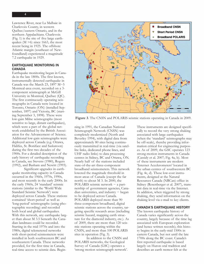
ning in 1991, the Canadian NationalSeismograph Network (CNSN) wascompletely modernized (North andBeverley 1994), with digital data fromapproximately 80 sites being continu-ously transmitted in real-time (via satel-lite links, dedicated phone lines, andUHF radio links) to data processingcentres in Sidney, BC and Ottawa, ON.Nearly half of the stations includedstate-of-the-art three-componentbroadband seismometers. This networklowered the magnitude threshold inmost areas of Canada (except the farnorth) to about M 3. In 2000, thePOLARIS seismic network − a part-nership of government agencies, Cana-dian universities, and industry − beganto be deployed across Canada.POLARIS deployed more than 90three-component broadband, digitalseismic stations across the country, tar-geting specific research areas (includingseismic hazard, mapping earth struc-ture for the diamond industry, etc.). Asof 2009, there are more than 120 seis-mic stations operating within theCNSN, and more than 100 POLARISsites in operation (Fig. 3).
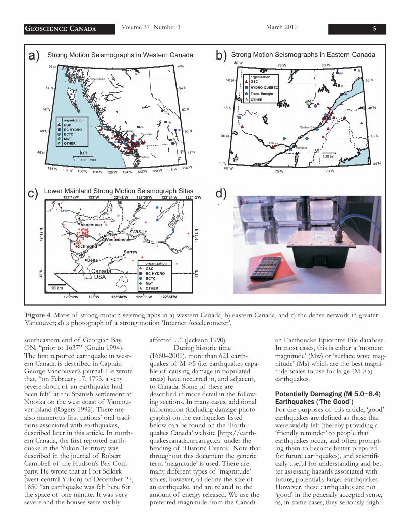
In addition to the CNSN andPOLARIS networks, the GeologicalSurvey of Canada (GSC) operates a‘strong motion seismograph network’.
These instruments are designed specifi-cally to record the very strong shakingassociated with large earthquakes(when the ‘standard’ seismographs maybe off-scale), thereby providing infor-mation critical for engineering purpos-es. As of 2009, the GSC operates 123strong-motion instruments in Canada(Cassidy et al. 2007; Fig. 4a, b). Mostof these instruments are modern‘Internet Accelerometers’ located inthe urban centres of southwestern BC(Fig. 4c, d). These low-cost instru-ments, designed at the NaturalResources Canada (NRCan) office inSidney (Rosenberger et al. 2007), trans-mit data in real-time via the Internet.In addition, when triggered by strongshaking, they send information on theshaking level via e-mail to key clients.
CANADA’S EARTHQUAKE HISTORYThe known earthquake history ofCanada varies significantly across thecountry, largely because of the time lagassociated with European exploration(and hence written records); this histo-ry begins in the early-mid 1500s ineastern Canada, but not until the late1700s along the BC coast. Canada’sfirst reported earthquake is basedlargely on Huron oral tradition anddescribes an earth tremor felt at the
4
Figure 3. The CNSN and POLARIS seismic stations operating in Canada in 2009.
southeastern end of Georgian Bay,ON, “prior to 1637” (Gouin 1994).The first reported earthquake in west-ern Canada is described in CaptainGeorge Vancouver’s journal. He wrotethat, “on February 17, 1793, a verysevere shock of an earthquake hadbeen felt” at the Spanish settlement atNootka on the west coast of Vancou-ver Island (Rogers 1992). There arealso numerous first nations’ oral tradi-tions associated with earthquakes,described later in this article. In north-ern Canada, the first reported earth-quake in the Yukon Territory wasdescribed in the journal of RobertCampbell of the Hudson’s Bay Com-pany. He wrote that at Fort Selkirk(west-central Yukon) on December 27,1850 “an earthquake was felt here forthe space of one minute. It was verysevere and the houses were visibly
affected…” (Jackson 1990). During historic time
(1660–2009), more than 621 earth-quakes of M >5 (i.e. earthquakes capa-ble of causing damage in populatedareas) have occurred in, and adjacent,to Canada. Some of these aredescribed in more detail in the follow-ing sections. In many cases, additionalinformation (including damage photo-graphs) on the earthquakes listedbelow can be found on the ‘Earth-quakes Canada’ website [http://earth-quakescanada.nrcan.gc.ca] under theheading of ‘Historic Events’. Note thatthroughout this document the genericterm ‘magnitude’ is used. There aremany different types of ‘magnitude’scales; however, all define the size ofan earthquake, and are related to theamount of energy released. We use thepreferred magnitude from the Canadi-
an Earthquake Epicentre File database.In most cases, this is either a ‘momentmagnitude’ (Mw) or ‘surface wave mag-nitude’ (Ms) which are the best magni-tude scales to use for large (M >5)earthquakes.
Potentially Damaging (M 5.0−6.4)Earthquakes (‘The Good’) For the purposes of this article, ‘good’earthquakes are defined as those thatwere widely felt (thereby providing a‘friendly reminder’ to people thatearthquakes occur, and often prompt-ing them to become better preparedfor future earthquakes), and scientifi-cally useful for understanding and bet-ter assessing hazards associated withfuture, potentially larger earthquakes.However, these earthquakes are not‘good’ in the generally accepted sense,as, in some cases, they seriously fright-
GEOSCIENCE CANADA Volume 37 Number 1 March 2010 5
Figure 4. Maps of strong-motion seismographs in a) western Canada, b) eastern Canada, and c) the dense network in greaterVancouver; d) a photograph of a strong motion ‘Internet Accelerometer’.
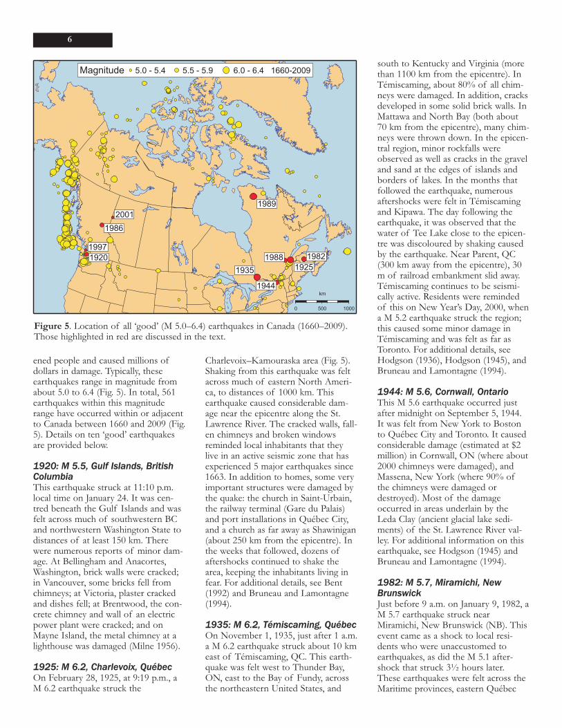
ened people and caused millions ofdollars in damage. Typically, theseearthquakes range in magnitude fromabout 5.0 to 6.4 (Fig. 5). In total, 561earthquakes within this magnituderange have occurred within or adjacentto Canada between 1660 and 2009 (Fig.5). Details on ten ‘good’ earthquakesare provided below.
1920: M 5.5, Gulf Islands, BritishColumbiaThis earthquake struck at 11:10 p.m.local time on January 24. It was cen-tred beneath the Gulf Islands and wasfelt across much of southwestern BCand northwestern Washington State todistances of at least 150 km. Therewere numerous reports of minor dam-age. At Bellingham and Anacortes,Washington, brick walls were cracked;in Vancouver, some bricks fell fromchimneys; at Victoria, plaster crackedand dishes fell; at Brentwood, the con-crete chimney and wall of an electricpower plant were cracked; and onMayne Island, the metal chimney at alighthouse was damaged (Milne 1956).
1925: M 6.2, Charlevoix, QuébecOn February 28, 1925, at 9:19 p.m., aM 6.2 earthquake struck the
Charlevoix–Kamouraska area (Fig. 5).Shaking from this earthquake was feltacross much of eastern North Ameri-ca, to distances of 1000 km. Thisearthquake caused considerable dam-age near the epicentre along the St.Lawrence River. The cracked walls, fall-en chimneys and broken windowsreminded local inhabitants that theylive in an active seismic zone that hasexperienced 5 major earthquakes since1663. In addition to homes, some veryimportant structures were damaged bythe quake: the church in Saint-Urbain,the railway terminal (Gare du Palais)and port installations in Québec City,and a church as far away as Shawinigan(about 250 km from the epicentre). Inthe weeks that followed, dozens ofaftershocks continued to shake thearea, keeping the inhabitants living infear. For additional details, see Bent(1992) and Bruneau and Lamontagne(1994).
1935: M 6.2, Témiscaming, QuébecOn November 1, 1935, just after 1 a.m.a M 6.2 earthquake struck about 10 kmeast of Témiscaming, QC. This earth-quake was felt west to Thunder Bay,ON, east to the Bay of Fundy, acrossthe northeastern United States, and
south to Kentucky and Virginia (morethan 1100 km from the epicentre). InTémiscaming, about 80% of all chim-neys were damaged. In addition, cracksdeveloped in some solid brick walls. InMattawa and North Bay (both about70 km from the epicentre), many chim-neys were thrown down. In the epicen-tral region, minor rockfalls wereobserved as well as cracks in the graveland sand at the edges of islands andborders of lakes. In the months thatfollowed the earthquake, numerousaftershocks were felt in Témiscamingand Kipawa. The day following theearthquake, it was observed that thewater of Tee Lake close to the epicen-tre was discoloured by shaking causedby the earthquake. Near Parent, QC(300 km away from the epicentre), 30m of railroad embankment slid away.Témiscaming continues to be seismi-cally active. Residents were remindedof this on New Year’s Day, 2000, whena M 5.2 earthquake struck the region;this caused some minor damage inTémiscaming and was felt as far asToronto. For additional details, seeHodgson (1936), Hodgson (1945), andBruneau and Lamontagne (1994).
1944: M 5.6, Cornwall, OntarioThis M 5.6 earthquake occurred justafter midnight on September 5, 1944.It was felt from New York to Bostonto Québec City and Toronto. It causedconsiderable damage (estimated at $2million) in Cornwall, ON (where about2000 chimneys were damaged), andMassena, New York (where 90% ofthe chimneys were damaged ordestroyed). Most of the damageoccurred in areas underlain by theLeda Clay (ancient glacial lake sedi-ments) of the St. Lawrence River val-ley. For additional information on thisearthquake, see Hodgson (1945) andBruneau and Lamontagne (1994).
1982: M 5.7, Miramichi, NewBrunswickJust before 9 a.m. on January 9, 1982, aM 5.7 earthquake struck nearMiramichi, New Brunswick (NB). Thisevent came as a shock to local resi-dents who were unaccustomed toearthquakes, as did the M 5.1 after-shock that struck 3½ hours later.These earthquakes were felt across theMaritime provinces, eastern Québec
6
Figure 5. Location of all ‘good’ (M 5.0–6.4) earthquakes in Canada (1660–2009).Those highlighted in red are discussed in the text.
and the New England states, to dis-tances of about 350 km from the epi-centre. People in highrises in Ottawaand New York City felt swaying fromthe surface waves generated by thisearthquake. Fortunately, because theimmediate epicentral area was unpopu-lated, damage was very slight: a fewhairline cracks but no structural dam-age in buildings up to 100 km away.Although there was no evidence forrupture at the surface, high-quality dig-ital data and monitoring of aftershocksshowed a very clear ‘image’ of a west-dipping rupture zone (fault) just belowthe surface. For more information, seeBasham et al. (1982) and Basham andAdams (1984).
1986: M 5.4, Prince George, BritishColumbiaOn March 21, 1986 at 3:56 p.m. awidely felt M 5.4 earthquake occurredin an area of low historic seismicityjust west of the Rocky Mountains ineast-central BC (Fig. 5). The epicentralregion is sparsely populated and onlyminor damage (mainly to older mason-ry chimneys) occurred, although theearthquake was felt strongly in PrinceGeorge, 70 km to the west. Within 48hours of the main shock, portableshort-period seismographs weredeployed in the epicentral region andoperated for eight days. The few after-shocks that were recorded were con-fined to a depth range of 9 to 16 km,and the largest was M 2.5. No fore-shocks were detected by the CNSN.The occurrence of this earthquake andseveral other moderate-to-large earth-quakes in the northern and centralparts of the eastern Cordillera raisesthe question of the level of seismichazard in the more populated southernsection of the eastern Cordillera. Foradditional details on this earthquakesee Rogers et al. (1990).
1988: M 5.9, Saguenay, QuébecOn Friday, November 25, 1988 at 6:46p.m. the largest earthquake in easternNorth America in 53 years occurred 35km south of Chicoutimi, QC andabout 150 km north of Québec City(North et al. 1989). The epicentre waslocated in a relatively ‘seismically quiet’area, and had a deep focus (29 kmbeneath the surface). Few aftershockswere recorded, but it was preceded by
a foreshock of M 4.7 on November23, 1988. It was felt as far away asDetroit, Boston, Halifax, and southernLabrador. Damage in the sparsely pop-ulated epicentral area was modest, lim-ited to cracked or fallen un-reinforcedmasonry walls; however, eleven land-slides were attributed to the earth-quake. Damage outside the epicentralarea was correlated with underlyingunconsolidated sediments; for example,nearly 350 km from the epicentre, theformer Montréal Est City Hall (builton 17 m of clay) suffered severe dam-age to its masonry cladding. Detailedanalysis of seismic data from thisearthquake by a large number ofresearchers (e.g. Hough et al. 1989;Boore and Atkinson 1992; Boatwrightand Choy 1992; Somerville et al. 1990)has provided valuable insight into thenature of moderate earthquakes ineastern North America. For example,the strong ground motion recordingsexceeded predicted levels, which Had-don (1992) attributed to the directionand focusing of seismic energy, where-as other researchers (Boore and Atkin-son 1992) related it to the earthquakesource properties and directional dif-ferences in how seismic waves attenu-ate.
1989: M 6.3, Ungava, Québec On December 25, 1989 a M 6.3 earth-quake occurred in the remote area ofUngava, in northern Québec. Onlyweakly felt at distant villages alongUngava Bay, this was one of the mostsignificant earthquakes of the century,as it provided the first historical evi-dence for surface faulting in easternNorth America (Adams et al. 1991). Italso allowed, for the first time in east-ern North America, an opportunity tocompare the extent and magnitude ofsurface faulting and regional deforma-tion with waveform modelling of therupture process (Bent 1994) and after-shock distribution. The surface effectsalso indicate the type of evidence to besought from prehistoric ruptures. Theobservation of surface faulting, andcomparison with modelling from theseismic observations, was a major leapforward in constraining seismic hazardin eastern North America.
1997: M 4.7, Georgia Strait, BritishColumbiaAt 7:40 a.m. on June 24, 1997, a M 4.7earthquake struck southwestern BC.This earthquake, located beneath theStrait of Georgia midway between thepopulation centres of Vancouver (30km to the east) and Nanaimo (30 kmto the west), was felt across most ofVancouver Island and east as far asAbbotsford (100 km away). Minordamage included broken glass in Van-couver and a broken water pipe inNorth Vancouver. This earthquaketriggered a rush on purchases of earth-quake preparedness kits in the region.Detailed analysis of this earthquakeand its aftershock sequence (Cassidy etal. 2000) provided the first ‘image’ ofan active fault in southwestern BC. Fordetails, see Cassidy et al. (2000) andMosher et al. (2000).
2001: M 5.3, Near Dawson Creek,British ColumbiaAt 8:20 p.m. on Friday, April 13, 2001,residents of northwestern Alberta(AB) and northeastern BC were sur-prised by a M 5.4 earthquake, thelargest ever recorded in that ‘seismical-ly quiet’ region; the epicentre waslocated 40 km to the northeast ofDawson Creek, BC. This earthquakewas felt in Edmonton, AB (500 km tothe east), Prince George, BC (300 kmto the southwest) and Fort Nelson, BC(340 km to the northwest). Althoughthere were no reports of structuraldamage, items were knocked fromshelves, and, like the 1986 PrinceGeorge earthquake, it served as a‘friendly reminder’ of earthquake haz-ards in the Cordillera.
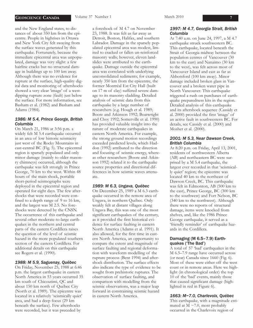
Damaging (M 6.5–7.9) Earth-quakes (‘The Bad’) A total of 57 ‘bad’ earthquakes in theM 6.5–7.9 range have occurred across(or near) Canada since 1660 (Fig. 6).Most of these were either off the westcoast or in remote areas. Here we high-light (in chronological order) the top10 of the ‘bad’ events, mainly thosethat caused significant damage (high-lighted in red in Figure 6).
1663: M~7.0, Charlevoix, QuébecThis earthquake, with a magnitude esti-mated at M ~7.0, most probablyoccurred in the Charlevoix region of
GEOSCIENCE CANADA Volume 37 Number 1 March 2010 7
Québec (Fig. 6). It was felt over theentire eastern part of North America(an area of about 2 million km2; Gouin2001). At the time, most of the popu-lation of New France lived in QuébecCity, Trois-Rivières and Montreal (allmore than 100 km away from the epi-centre), which may explain why no lossof life was reported and damage wasconfined to a few cracked and brokenchimneys and items being tossed fromshelves. The earthquake triggeredlarge landslides over a vast area, includ-ing the Charlevoix region and alongthe St. Lawrence, Shipshaw, Betsi-amites, Pentecôte, Batiscan, and Saint-Maurice rivers.
1872: M 6.8, Northern WashingtonState, USA This M 6.8 earthquake (Bakun et al.2002) was located about 250 km south-east of Vancouver, BC. It occurredwithin the North American Plate, andwas felt from Quesnel (nearly 600 kmto the north) to Eugene, Oregon (500km to the south). Strong shaking wasreported in Victoria, where items wereknocked from shelves and people ranout into the streets (Milne 1956).Numerous aftershocks were felt formore than a year following this earth-
quake (Bakun et al. 2002).
1918: M 6.9, Vancouver Island,British ColumbiaThis large, M 6.9, earthquake occurredjust after midnight local time on Friday,December 6, 1918. It occurred nearthe west coast of Vancouver Island,and was felt very strongly at EstevanPoint lighthouse and at Nootka light-house on the southern tip of NootkaIsland. There was damage to the Este-van Point lighthouse (rendering it inop-erable) and to a wharf at Ucluelet. Thisearthquake awakened and frightenedpeople all over Vancouver Island andin the greater Vancouver area. It wasfelt in northern Washington State andat Kelowna, more than 500 km to theeast in the interior of BC. The earth-quake occurred within the NorthAmerican plate, and was followed by atleast 14 aftershocks (including one aslarge as M 5.6). For more details seeCassidy et al. (1988).
1929: M 7.0, Queen CharlotteIslands, British ColumbiaThis M 7.0 earthquake occurred onMay 26, 1929, along the Queen Char-lotte Fault, about 50 km south of theQueen Charlotte Islands. The earth-
quake was felt from Ketchikan, Alaska,450 km to the north, to Terrace andSkeena, BC, nearly 400 km to the east.The strongest shaking was reported onthe Queen Charlottes: at Masset (300km distance), houses shook violently;at Queen Charlotte City and Skidegate,dishes were broken and a 1 m localtsunami was reported; at Sandspit, 500feet of beach was reported to have dis-appeared into the sea; and at RoseHarbour, chimneys toppled. For moredetails, see Milne (1956), and Rogers(1986).
1929: M 7.2, Grand Banks, New-foundlandThis M 7.2 earthquake struck at 5:02p.m. on November 18, 1929. It waslocated about 250 km south of New-foundland, along the southern edge ofthe Grand Banks and was felt as faraway as New York (nearly 1500 km tothe southwest) and Ottawa (nearly1500 km to the west). On land, dam-age caused by shaking was limited toCape Breton Island, where chimneyswere overthrown or cracked and wheresome highways were blocked by minorlandslides. This earthquake is mostnotable for the devastating tsunamithat was generated by a large subma-rine slump (estimated at 200 km³ ofmaterial) triggered by the earthquakeshaking (Fig. 7). The tsunami killed 28people in Newfoundland, and wasrecorded along the Atlantic seaboardof the US and across the Atlantic inPortugal. The underwater slump alsoruptured 12 transatlantic cables in mul-tiple locations. For more details on thisearthquake, see Bent (1995) and Ruff-man and Hann (2006).
1933: M 7.3, Baffin Bay, NunavutThis earthquake is the largest instru-mentally recorded earthquake to haveoccurred along the passive margin ofNorth America and is also the largestknown earthquake north of the ArcticCircle. In spite of its intensity, the 1933earthquake did not result in any dam-age because of its offshore locationand the sparse population of the adja-cent onshore regions (the closest com-munities were more than 200 kmaway). For more information see Bent(2002).
8
Figure 6. Location of all ‘bad’ (M 6.5–7.9) earthquakes in Canada (1660–2009).Those highlighted in red are discussed in the text.
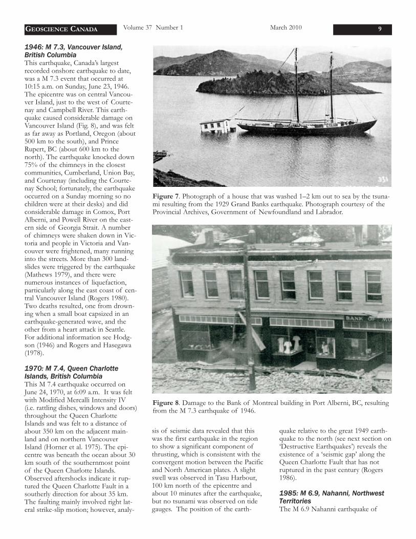
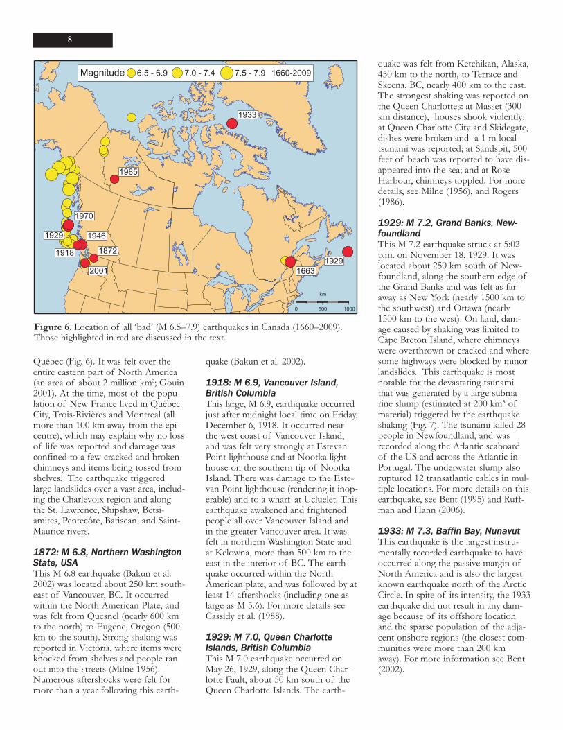
1946: M 7.3, Vancouver Island,British ColumbiaThis earthquake, Canada’s largestrecorded onshore earthquake to date,was a M 7.3 event that occurred at10:15 a.m. on Sunday, June 23, 1946.The epicentre was on central Vancou-ver Island, just to the west of Courte-nay and Campbell River. This earth-quake caused considerable damage onVancouver Island (Fig. 8), and was feltas far away as Portland, Oregon (about500 km to the south), and PrinceRupert, BC (about 600 km to thenorth). The earthquake knocked down75% of the chimneys in the closestcommunities, Cumberland, Union Bay,and Courtenay (including the Courte-nay School; fortunately, the earthquakeoccurred on a Sunday morning so nochildren were at their desks) and didconsiderable damage in Comox, PortAlberni, and Powell River on the east-ern side of Georgia Strait. A numberof chimneys were shaken down in Vic-toria and people in Victoria and Van-couver were frightened, many runninginto the streets. More than 300 land-slides were triggered by the earthquake(Mathews 1979), and there werenumerous instances of liquefaction,particularly along the east coast of cen-tral Vancouver Island (Rogers 1980).Two deaths resulted, one from drown-ing when a small boat capsized in anearthquake-generated wave, and theother from a heart attack in Seattle.For additional information see Hodg-son (1946) and Rogers and Hasegawa(1978).
1970: M 7.4, Queen CharlotteIslands, British ColumbiaThis M 7.4 earthquake occurred onJune 24, 1970, at 6:09 a.m. It was feltwith Modified Mercalli Intensity IV(i.e. rattling dishes, windows and doors)throughout the Queen CharlotteIslands and was felt to a distance ofabout 350 km on the adjacent main-land and on northern VancouverIsland (Horner et al. 1975). The epi-centre was beneath the ocean about 30km south of the southernmost pointof the Queen Charlotte Islands.Observed aftershocks indicate it rup-tured the Queen Charlotte Fault in asoutherly direction for about 35 km.The faulting mainly involved right lat-eral strike-slip motion; however, analy-
sis of seismic data revealed that thiswas the first earthquake in the regionto show a significant component ofthrusting, which is consistent with theconvergent motion between the Pacificand North American plates. A slightswell was observed in Tasu Harbour,100 km north of the epicentre andabout 10 minutes after the earthquake,but no tsunami was observed on tidegauges. The position of the earth-
quake relative to the great 1949 earth-quake to the north (see next section on‘Destructive Earthquakes’) reveals theexistence of a ‘seismic gap’ along theQueen Charlotte Fault that has notruptured in the past century (Rogers1986).
1985: M 6.9, Nahanni, NorthwestTerritoriesThe M 6.9 Nahanni earthquake of
GEOSCIENCE CANADA Volume 37 Number 1 March 2010 9
Figure 7. Photograph of a house that was washed 1–2 km out to sea by the tsuna-mi resulting from the 1929 Grand Banks earthquake. Photograph courtesy of theProvincial Archives, Government of Newfoundland and Labrador.
Figure 8. Damage to the Bank of Montreal building in Port Alberni, BC, resultingfrom the M 7.3 earthquake of 1946.
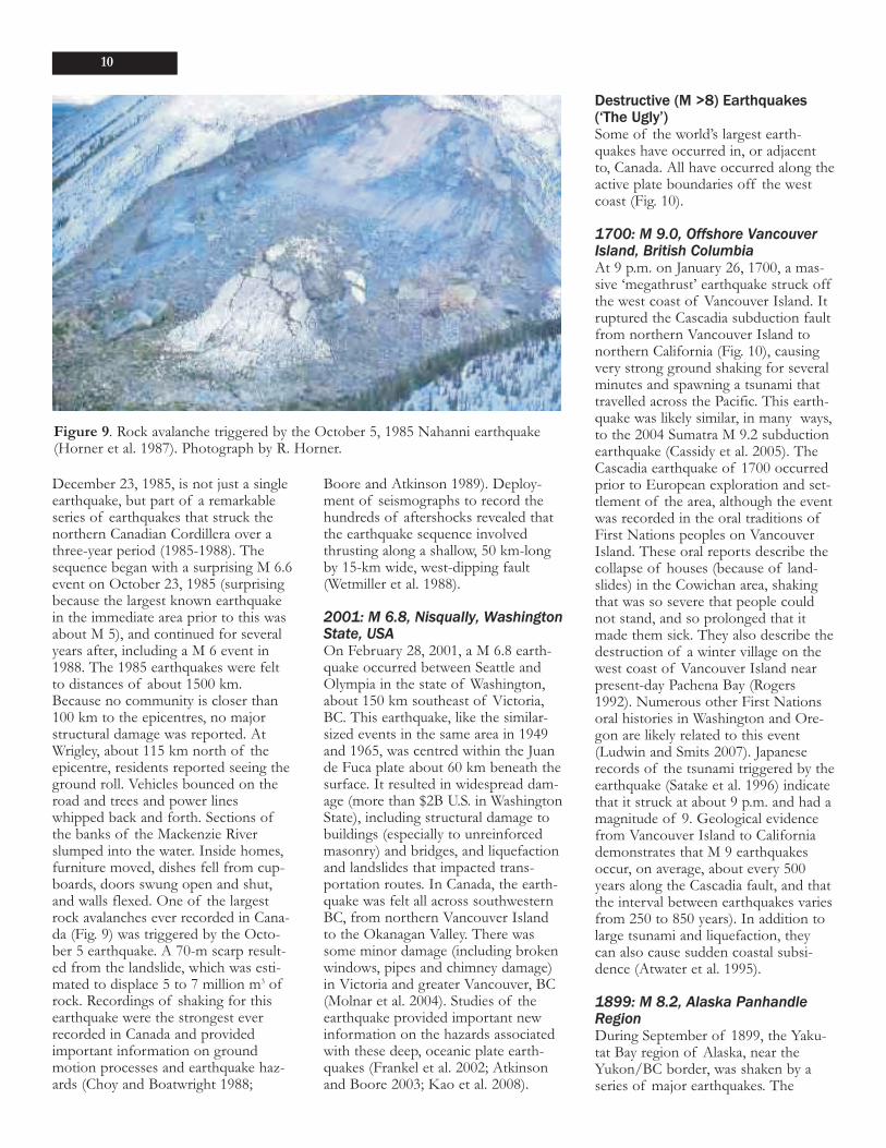
December 23, 1985, is not just a singleearthquake, but part of a remarkableseries of earthquakes that struck thenorthern Canadian Cordillera over athree-year period (1985-1988). Thesequence began with a surprising M 6.6event on October 23, 1985 (surprisingbecause the largest known earthquakein the immediate area prior to this wasabout M 5), and continued for severalyears after, including a M 6 event in1988. The 1985 earthquakes were feltto distances of about 1500 km.Because no community is closer than100 km to the epicentres, no majorstructural damage was reported. AtWrigley, about 115 km north of theepicentre, residents reported seeing theground roll. Vehicles bounced on theroad and trees and power lineswhipped back and forth. Sections ofthe banks of the Mackenzie Riverslumped into the water. Inside homes,furniture moved, dishes fell from cup-boards, doors swung open and shut,and walls flexed. One of the largestrock avalanches ever recorded in Cana-da (Fig. 9) was triggered by the Octo-ber 5 earthquake. A 70-m scarp result-ed from the landslide, which was esti-mated to displace 5 to 7 million m3 ofrock. Recordings of shaking for thisearthquake were the strongest everrecorded in Canada and providedimportant information on groundmotion processes and earthquake haz-ards (Choy and Boatwright 1988;
Boore and Atkinson 1989). Deploy-ment of seismographs to record thehundreds of aftershocks revealed thatthe earthquake sequence involvedthrusting along a shallow, 50 km-longby 15-km wide, west-dipping fault(Wetmiller et al. 1988).
2001: M 6.8, Nisqually, WashingtonState, USAOn February 28, 2001, a M 6.8 earth-quake occurred between Seattle andOlympia in the state of Washington,about 150 km southeast of Victoria,BC. This earthquake, like the similar-sized events in the same area in 1949and 1965, was centred within the Juande Fuca plate about 60 km beneath thesurface. It resulted in widespread dam-age (more than $2B U.S. in WashingtonState), including structural damage tobuildings (especially to unreinforcedmasonry) and bridges, and liquefactionand landslides that impacted trans-portation routes. In Canada, the earth-quake was felt all across southwesternBC, from northern Vancouver Islandto the Okanagan Valley. There wassome minor damage (including brokenwindows, pipes and chimney damage)in Victoria and greater Vancouver, BC(Molnar et al. 2004). Studies of theearthquake provided important newinformation on the hazards associatedwith these deep, oceanic plate earth-quakes (Frankel et al. 2002; Atkinsonand Boore 2003; Kao et al. 2008).
Destructive (M >8) Earthquakes(‘The Ugly’)Some of the world’s largest earth-quakes have occurred in, or adjacentto, Canada. All have occurred along theactive plate boundaries off the westcoast (Fig. 10).
1700: M 9.0, Offshore VancouverIsland, British ColumbiaAt 9 p.m. on January 26, 1700, a mas-sive ‘megathrust’ earthquake struck offthe west coast of Vancouver Island. Itruptured the Cascadia subduction faultfrom northern Vancouver Island tonorthern California (Fig. 10), causingvery strong ground shaking for severalminutes and spawning a tsunami thattravelled across the Pacific. This earth-quake was likely similar, in many ways,to the 2004 Sumatra M 9.2 subductionearthquake (Cassidy et al. 2005). TheCascadia earthquake of 1700 occurredprior to European exploration and set-tlement of the area, although the eventwas recorded in the oral traditions ofFirst Nations peoples on VancouverIsland. These oral reports describe thecollapse of houses (because of land-slides) in the Cowichan area, shakingthat was so severe that people couldnot stand, and so prolonged that itmade them sick. They also describe thedestruction of a winter village on thewest coast of Vancouver Island nearpresent-day Pachena Bay (Rogers1992). Numerous other First Nationsoral histories in Washington and Ore-gon are likely related to this event(Ludwin and Smits 2007). Japaneserecords of the tsunami triggered by theearthquake (Satake et al. 1996) indicatethat it struck at about 9 p.m. and had amagnitude of 9. Geological evidencefrom Vancouver Island to Californiademonstrates that M 9 earthquakesoccur, on average, about every 500years along the Cascadia fault, and thatthe interval between earthquakes variesfrom 250 to 850 years). In addition tolarge tsunami and liquefaction, theycan also cause sudden coastal subsi-dence (Atwater et al. 1995).
1899: M 8.2, Alaska PanhandleRegionDuring September of 1899, the Yaku-tat Bay region of Alaska, near theYukon/BC border, was shaken by aseries of major earthquakes. The
10
Figure 9. Rock avalanche triggered by the October 5, 1985 Nahanni earthquake(Horner et al. 1987). Photograph by R. Horner.
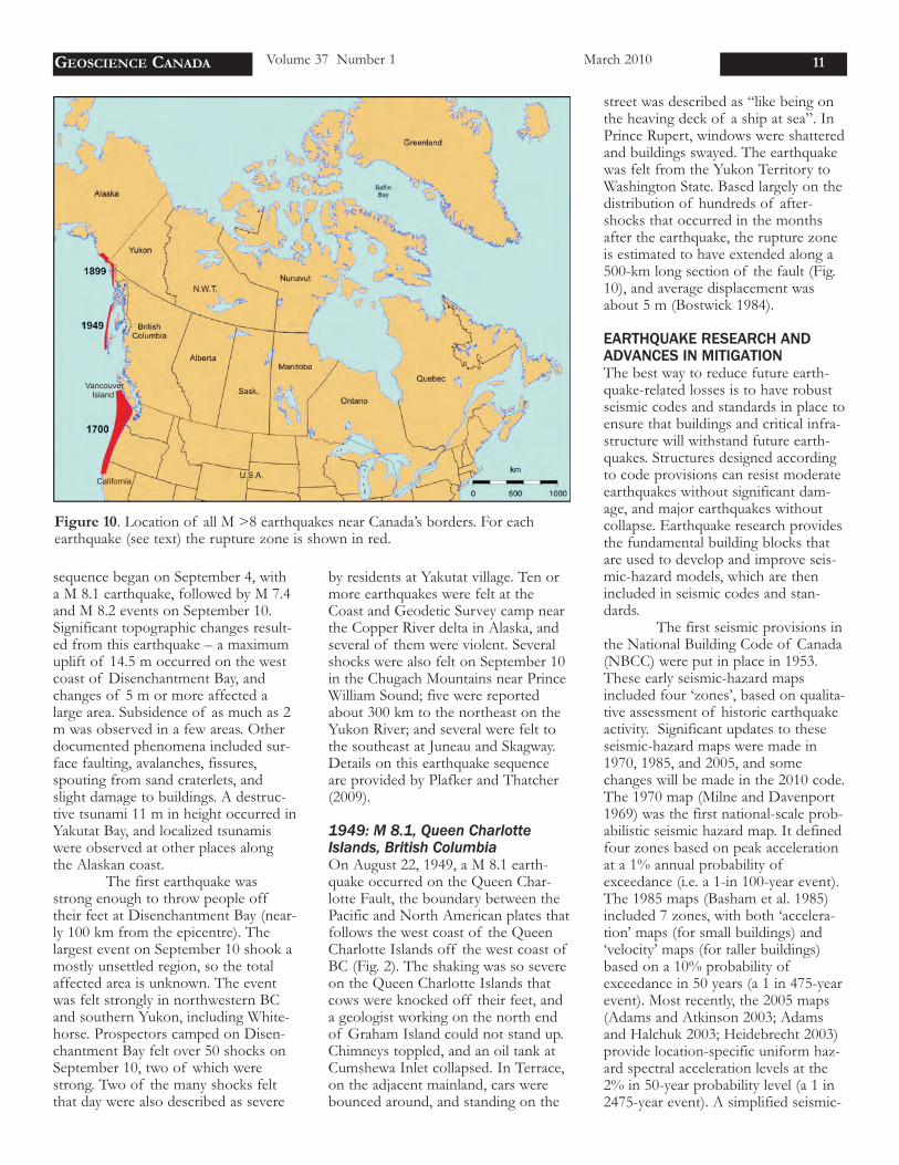
sequence began on September 4, witha M 8.1 earthquake, followed by M 7.4and M 8.2 events on September 10.Significant topographic changes result-ed from this earthquake – a maximumuplift of 14.5 m occurred on the westcoast of Disenchantment Bay, andchanges of 5 m or more affected alarge area. Subsidence of as much as 2m was observed in a few areas. Otherdocumented phenomena included sur-face faulting, avalanches, fissures,spouting from sand craterlets, andslight damage to buildings. A destruc-tive tsunami 11 m in height occurred inYakutat Bay, and localized tsunamiswere observed at other places alongthe Alaskan coast.
The first earthquake wasstrong enough to throw people offtheir feet at Disenchantment Bay (near-ly 100 km from the epicentre). Thelargest event on September 10 shook amostly unsettled region, so the totalaffected area is unknown. The eventwas felt strongly in northwestern BCand southern Yukon, including White-horse. Prospectors camped on Disen-chantment Bay felt over 50 shocks onSeptember 10, two of which werestrong. Two of the many shocks feltthat day were also described as severe
by residents at Yakutat village. Ten ormore earthquakes were felt at theCoast and Geodetic Survey camp nearthe Copper River delta in Alaska, andseveral of them were violent. Severalshocks were also felt on September 10in the Chugach Mountains near PrinceWilliam Sound; five were reportedabout 300 km to the northeast on theYukon River; and several were felt tothe southeast at Juneau and Skagway.Details on this earthquake sequenceare provided by Plafker and Thatcher(2009).
1949: M 8.1, Queen CharlotteIslands, British ColumbiaOn August 22, 1949, a M 8.1 earth-quake occurred on the Queen Char-lotte Fault, the boundary between thePacific and North American plates thatfollows the west coast of the QueenCharlotte Islands off the west coast ofBC (Fig. 2). The shaking was so severeon the Queen Charlotte Islands thatcows were knocked off their feet, anda geologist working on the north endof Graham Island could not stand up.Chimneys toppled, and an oil tank atCumshewa Inlet collapsed. In Terrace,on the adjacent mainland, cars werebounced around, and standing on the
street was described as “like being onthe heaving deck of a ship at sea”. InPrince Rupert, windows were shatteredand buildings swayed. The earthquakewas felt from the Yukon Territory toWashington State. Based largely on thedistribution of hundreds of after-shocks that occurred in the monthsafter the earthquake, the rupture zoneis estimated to have extended along a500-km long section of the fault (Fig.10), and average displacement wasabout 5 m (Bostwick 1984).
EARTHQUAKE RESEARCH ANDADVANCES IN MITIGATIONThe best way to reduce future earth-quake-related losses is to have robustseismic codes and standards in place toensure that buildings and critical infra-structure will withstand future earth-quakes. Structures designed accordingto code provisions can resist moderateearthquakes without significant dam-age, and major earthquakes withoutcollapse. Earthquake research providesthe fundamental building blocks thatare used to develop and improve seis-mic-hazard models, which are thenincluded in seismic codes and stan-dards.
The first seismic provisions inthe National Building Code of Canada(NBCC) were put in place in 1953.These early seismic-hazard mapsincluded four ‘zones’, based on qualita-tive assessment of historic earthquakeactivity. Significant updates to theseseismic-hazard maps were made in1970, 1985, and 2005, and somechanges will be made in the 2010 code.The 1970 map (Milne and Davenport1969) was the first national-scale prob-abilistic seismic hazard map. It definedfour zones based on peak accelerationat a 1% annual probability ofexceedance (i.e. a 1-in 100-year event).The 1985 maps (Basham et al. 1985)included 7 zones, with both ‘accelera-tion’ maps (for small buildings) and‘velocity’ maps (for taller buildings)based on a 10% probability ofexceedance in 50 years (a 1 in 475-yearevent). Most recently, the 2005 maps(Adams and Atkinson 2003; Adamsand Halchuk 2003; Heidebrecht 2003)provide location-specific uniform haz-ard spectral acceleration levels at the2% in 50-year probability level (a 1 in2475-year event). A simplified seismic-
GEOSCIENCE CANADA Volume 37 Number 1 March 2010 11
Figure 10. Location of all M >8 earthquakes near Canada’s borders. For eachearthquake (see text) the rupture zone is shown in red.
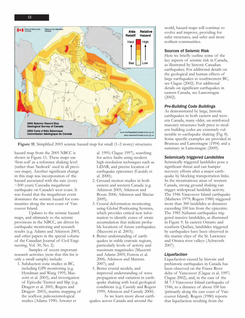
hazard map from the 2005 NBCC isshown in Figure 11. These maps use‘firm-soil’ as a reference shaking level(rather than ‘bedrock’ used in all previ-ous maps). Another significant changein this map was incorporation of thehazard associated with the rare (every~500 years) Cascadia megathrustearthquake on Canada’s west coast. Itwas found that the megathrust eventdominates the seismic hazard for com-munities along the west coast of Van-couver Island.
Updates to the seismic hazardmaps, and ultimately to the seismicprovisions in the NBCC, are driven byearthquake monitoring and researchresults (e.g. Adams and Atkinson 2003,and other papers in the special volumeof the Canadian Journal of Civil Engi-neering, Vol. 30, No. 2).
Samples of recent importantresearch activities (note that this list isonly a small sample) include:
1. Subduction zone studies in BC,including GPS monitoring (e.g.Hyndman and Wang 1995; Maz-zotti et al. 2003), and investigationof Episodic Tremor and Slip (e.g.Dragert et al. 2001; Rogers andDragert 2003), marine mapping ofthe seafloor, paleoseismologicalstudies (Adams 1990; Atwater et
al. 1995; Clague 1997), searchingfor active faults using modernhigh-resolution techniques such asLiDAR, and precise location ofearthquake epicentres (Cassidy etal. 2000);
2. Ground motion studies in botheastern and western Canada (e.g.Atkinson 2005; Atkinson andBoore 2006; Atkinson and Macias2009);
3. Crustal deformation monitoringusing Global Positioning Systems,which provides critical new infor-mation to identify zones of strainaccumulation that indicate proba-ble locations of future earthquakes(Mazzotti et al. 2003);
4. Better understanding of earth-quakes in stable cratonic regions,particularly levels of activity andmaximum magnitudes (Mazzottiand Adams 2005; Fenton et al.2006; Atkinson and Martens2007); and
5. Better crustal models, andimproved understanding of wavepropagation and variation in earth-quake shaking with local geologicalconditions (e.g. Cassidy and Rogers1999; Atkinson and Cassidy 2000).
As we learn more about earth-quakes across Canada and around the
world, hazard maps will continue toevolve and improve, providing forsafer structures, and safer and moreresilient communities.
Sources of Seismic RiskHere we briefly outline some of thekey aspects of seismic risk in Canada,as illustrated by historic Canadianearthquakes. For additional details onthe geological and human effects oflarge earthquakes in southwestern BC,see Clague (2002). For additionaldetails on significant earthquakes ineastern Canada, see Lamontagne(2002).
Pre-Building Code BuildingsAs demonstrated by large, historicearthquakes in both eastern and west-ern Canada, many older, un-reinforcedmasonry structures built prior to mod-ern building codes are extremely vul-nerable to earthquake shaking (Fig. 8).Some specific examples are provided inBruneau and Lamontagne (1994) and asummary in Lamontagne (2009).
Seismically triggered LandslidesSeismically triggered landslides pose asignificant threat and can hamperrecovery efforts after a major earth-quake by blocking transportation links.In the mountainous areas of westernCanada, strong ground shaking cantrigger widespread landslide activity.The 1946 Vancouver Island earthquake(Mathews 1979; Rogers 1980) triggeredmore than 300 landslides at distancesexceeding 100 km from the epicentre.The 1985 Nahanni earthquakes trig-gered massive landslides, as illustratedin Figure 9. In eastern Ontario andsouthern Québec, landslides triggeredby earthquakes have been observed inthe marine clays of the St. Lawrenceand Ottawa river valleys (Aylsworth2007).
LiquefactionLiquefaction caused by historic andprehistoric earthquakes in Canada hasbeen observed on the Fraser Riverdelta of Vancouver (Clague et al. 1997;Clague 2002), and, in the case of theM 7.3 Vancouver Island earthquake of1946, to a distance of about 100 km(primarily along the east coast of Van-couver Island). Rogers (1980) reportsthat liquefaction resulting from the
12
Figure 11. Simplified 2005 seismic hazard map for small (1–2 storey) structures.
1946 earthquake, caused extensivedamage to the wharf and cannerybuildings at Kildonan, as well as ‘spec-tacular downdrops and fountains ofblue clay that caked trees at ReidIsland’. Liquefaction effects have alsobeen observed for some earthquakes ineastern Canada (see Lamontagne 2002),including the deep (29 km beneath thesurface) 1988 Saguenay earthquake,which caused extensive liquefaction-related damage to local houses (Lefeb-vre et al. 1991).
Tsunamis and SeichesTsunamis triggered by both distant andlocal earthquakes have affected Cana-da, as demonstrated by the 1929 New-foundland tsunami, the 1964 tsunamiin Alberni Inlet on Vancouver Island(generated by the M 9.2 Alaska earth-quake) and the 1700 tsunami on Van-couver Island generated by a M 9.0Cascadia earthquake. For details, seeClague (2002). Seiches (standing wavesset up in bodies of water such as lakes,rivers, bays, or even swimming pools)can be generated when seismic wavesfrom an earthquake (including wavesfrom a very distant earthquake thatcannot be felt) pass through a region.Several good examples of seiches gen-erated in western Canada by the M 6.9Denali, Alaska earthquake of 2002 aredescribed in Cassidy and Rogers(2004).
Variation in Ground ShakingSoft soils and deep sedimentary basinssuch as the Fraser River delta nearVancouver can significantly alterground shaking. Examples of clearvariations in ground shaking acrossgreater Vancouver are described inCassidy and Rogers (1999) and Atkin-son and Cassidy (2000). Similarly, ineastern Canada, amplification ofground shaking associated with thick-nesses of soft Leda Clay has resultedin enhanced damage during past earth-quakes (Hodgson 1945; Lamontagne2009). Research on variations in earth-quake ground shaking is currentlyunderway in a number of urban cen-tres in eastern Canada, includingOttawa (e.g. Motazedian and Hunter2008). For a summary of some recentsite response studies across Canada seeCassidy and Molnar (2009).
CONCLUSIONLarge and damaging earthquakes havestruck Canada in the past, and willagain in the future. We cannot predictearthquakes at this time, and thereforeour best defense against earthquakes isto have modern earthquake codes andstandards, based on the latest earth-quake research. In addition, scientistsneed to continue to work with emer-gency response organizations, planners,and the public to maintain and raiseawareness of earthquake hazards andtheir potential impacts in Canada, andhelp prepare for future earthquakesthrough improved monitoring, mitiga-tion of effects, and emergency plans.
One of the primary goals ofthis article is to provide a reminder ofCanada’s past earthquakes−the ‘good’,the ‘bad’, and the ‘ugly’−so that we canbe better prepared for future earth-quakes.
ACKNOWLEDGEMENTSThe authors would like to thank ourmany colleagues who have deployedand operated seismograph stationsover the years, and who have locatedthousands of seismic events each year.We thank Richard Franklin for hisassistance with some of the graphics inthis article. We gratefully acknowledgeGail Atkinson, Ralph Currie, SonyaDehler, and Jane Wynne for their thor-ough review of this manuscript. This isGSC contribution number 20090113.
REFERENCESAdams, J., 1990, Paleoseismology of the
Cascadia subduction zone: Evidencefrom turbidites off the Oregon-Wash-ington margin: Tectonics, v. 9, p. 569-583.
Adams, J., and Basham, P. W., 1991, Theseismicity and seismotectonics of east-ern Canada, in Slemmons, D.B., Eng-dahl, E.R., Zoback, M.D., and Black-wekk, D.D., eds., The Geology ofNorth America: Decade Map Vol. 1:Geological Society of America, Neo-tectonics of North America, Boulder,Colorado, p. 261-275.
Adams, J., and Atkinson, G.M., 2003,Development of seismic hazard mapsfor the proposed 2005 edition of theNational Building Code of Canada:Canadian Journal of Civil Engineer-ing, v. 30, p. 255-271.
Adams J., and Halchuk, S., 2003, Fourthgeneration seismic hazard maps ofCanada: Values for over 650 Canadian
localities intended for the 2005National Building Code of Canada:Geological Survey of Canada OpenFile 4459, 155 p.
Adams, J., Wetmiller, R.J., Hasegawa, H.S.,and Drysdale, J., 1991, The first sur-face faulting from a historicalintraplate earthquake in North Ameri-ca: Nature, v. 352, p. 617-619.
Atkinson, G.M., 2005, Ground motions forearthquakes in southwestern BritishColumbia and northwestern Washing-ton: Crustal, in-slab, and offshoreevents: Bulletin of the SeismologicalSociety of America, v. 95, p. 1027-1044
Atkinson, G.M., and Cassidy, J.F., 2000,Integrated use of seismograph andstrong-motion data to determine soilamplification: Response of the FraserRiver delta to the Duvall and GeorgiaStrait earthquakes: Bulletin of theSeismological Society of America, v.90, p. 1028-1040.
Atkinson, G.M., and Boore, D.M., 2003,Empirical ground-motion relations forsubduction-zone earthquakes and theirapplication to Cascadia and otherregions: Bulletin of the SeismologicalSociety of America, v. 93, p. 1703-1729.
Atkinson, G.M., and Boore, D.M., 2006,Earthquake ground-motion predictionequations for eastern North America:Bulletin of the Seismological Societyof America, v. 96, p. 2181-2205.
Atkinson, G.M., and Martens, S.N., 2007,Seismic hazard estimates for sites inthe stable Canadian craton: CanadianJournal of Civil Engineering, v. 34, p.1299-1311.
Atkinson, G.M., and Macias, M., 2009, Pre-dicted ground motions for great inter-face earthquakes in the Cascadia Sub-duction zone: Bulletin of the Seismo-logical Society of America, v. 99, p.1552-1578.
Atwater, B.F., Nelson, A.R., Clague, J.J.,Carver, G.A., Yamaguchi, D.K.,Bobrowsky, P.T., Bourgeois, J.,Darienzo, M.E., Grant, W.C.,Hemphill-Haley, E., Kelsey, H.M.,Jacoby, G.C., Nishenko, S.P., Palmer,S.P., Peterson, C.D., and Reinhart,M.A., 1995, Summary of coastal geo-logic evidence for past great earth-quakes at the Cascadia subductionzone: Earthquake Spectra, v. 11, p. 1-18.
Aylsworth, J., 2007, Evidence of large mag-nitude Holocene earthquakes nearOttawa (abstract): Canadian Quater-nary Association, 2007 Conference,Program and Abstracts, p. 36.
Bakun, W.H., Haugerud, R.A., Hopper,
GEOSCIENCE CANADA Volume 37 Number 1 March 2010 13
M.G., and Ludwin, R.S., 2002, TheDecember 1872 Washington Stateearthquake: Bulletin of the Seismolog-ical Society of America, v. 92, p. 3239-3258.
Basham, P., and Adams, J., 1984, TheMiramichi, New Brunswick earth-quakes: Near-surface thrust faulting inthe northern Appalachians: Geo-science Canada, v. 11, p. 115-121.
Basham, P., and Newitt, L.R., 1993, A his-torical summary of Geological Surveyof Canada studies of earthquake seis-mology and geomagnetism: CanadianJournal of Earth Sciences, v. 30, p.372-390.
Basham, P.W., Stevens, A.E., Anglin, F.M.,and Wetmiller, R.J., 1982, Double-earthquake of Miramichi, NewBrunswick: GEOS (Energy Mines andResources Canada), v. 11, No. 2,[http://earthquakescanada.nrcan.gc.ca/histor/20th-eme/miramichi-eng.php].
Basham, P.W., Weichert, D., Anglin, F.M.,and Berry, M.J., 1985, New probabilis-tic strong seismic ground motionmaps of Canada: Bulletin of the Seis-mological Society of America, v. 75, p.563-595.
Bent, A. L., 1992, A re-examination of the1925 Charlevoix, Quebec earthquake:Bulletin of the Seismological Societyof America, v. 82, p. 2097-2113.
Bent, A. L., 1994, The 1989 (Ms 6.3)Ungava, Quebec earthquake: A com-plex intraplate event: Bulletin of theSeismological Society of America, v.84, p. 1075-1088.
Bent, A.L., 1995, A complex double-couplesource mechanism for the MS 7.2 1929Grand Banks Earthquake: Bulletin ofthe Seismological Society of America,v. 85, p. 1003-1020.
Bent, A.L., 2002, The 1933 Ms = 7.3 Baf-fin Bay earthquake: Strike-slip faultingalong the northeastern Canadian pas-sive margin: Geophysical JournalInternational, v. 150, p. 724-736.
Boatwright, J., and Choy, G.L. 1992, Accel-eration source spectra anticipated forlarge earthquakes in northeasternNorth America: Bulletin of the Seis-mological Society of America, v. 82, p.660-682.
Boore, D.M., and Atkinson, G., 1989,Spectral scaling of the 1985 to 1988Nahanni, Northwest Territories, earth-quakes: Bulletin of the SeismologicalSociety of America, v. 79, p. 1736-1761.
Boore, D.M., and Atkinson, G.M., 1992,Source spectra for the 1988 Saguenay,Quebec, earthquakes: Bulletin of theSeismological Society of America, v.
82, p. 683-719.Bostwick, T.K., 1984, A Re-examination of
the August 22, 1949 Queen CharlotteEarthquake: Unpublished M.Sc. The-sis, University of British Columbia,Vancouver, BC, 115 p.
Bruneau, M., and Lamontagne, M., 1994,Damage from 20th century earth-quakes in eastern Canada and seismicvulnerability of unreinforced masonrybuildings: Canadian Journal of CivilEngineering, v. 21, p. 643-662.
Cassidy, J.F., and Bent, A.L., 1993, Sourceparameters of the 29 May and 5 June,1940, Richardson Mountains, YukonTerritory, earthquakes: Bulletin of theSeismological Society of America, v.83, p. 636-659.
Cassidy, J.F., and Molnar, S., 2009, Recentearthquake site response studies inCanada, in Mucciarelli, M., Herak, M.,and Cassidy, J., eds., Increasing SeismicSafety by Combining EngineeringTechnologies and Seismological Data:NATO Science for Peace and SecuritySeries C, Environmental Security, p.257-279.
Cassidy, J.F., and Rogers, G.C., 1999, Seis-mic site response in the greater Van-couver, British Columbia area: Spectralratios from moderate earthquakes:Canadian Geotechnical Journal, v. 36,p. 195-209.
Cassidy, J.F., and Rogers, G.C., 2004, TheM=7.9 Denali Fault earthquake of 3November 2002: Felt reports andunusual effects across Western Cana-da: Bulletin of the Seismological Soci-ety of America, v. 94, p. S53-S57.
Cassidy, J.F., Ellis, R.M., and Rogers, G.C.,1988, The 1918 and 1957 VancouverIsland earthquakes: Bulletin of theSeismological Society of America, v.78, p. 617-635.
Cassidy, J.F., Rogers, G.C., and Waldhauser,F., 2000, Characterization of activefaulting beneath the Strait of Georgia,British Columbia: Bulletin of the Seis-mological Society of America, v. 90, p.1188-1199.
Cassidy, J.F., Rogers, G.C., Dragert, H., andWang, K., 2005, The 26 December,2004 M=9.0 Sumatra earthquake:Implications for Cascadia (abstract):Seismological Research Letters, v. 76,p. 220.
Cassidy, J.F., Rosenberger, A., Rogers, G.C.,Little, T., Toth, J., Adams, J., Munro,P., Huffman, S., Pierre, J.-R., Asmis,H., and Pernica, G., 2007, Strongmotion seismograph networks inCanada: Paper 1210, Proceedings ofthe 9th Canadian Conference on Earth-quake Engineering, Ottawa, ON, p.459-468.
Choy, G.L., and Boatwright, J., 1988, Tele-seismic and near-field analysis of theNahanni earthquakes in the North-west Territories, Canada: Bulletin ofthe Seismological Society of America,v. 78, p. 1627-1652.
Clague, J.J., 1997, Evidence for large earth-quakes at the Cascadia subductionzone: Reviews of Geophysics, v. 35, p.439-460.
Clague, J.J., 2002, The earthquake threat insouthwestern British Columbia: Ageologic perspective: Natural Hazards,v. 26, p. 7-34.
Clague, J.J., Naesgaard, E., and Nelson,A.R., 1997, Age and significance ofearthquake-induced liquefaction nearVancouver, British Columbia, Canada:Canadian Geotechnical Journal, v. 34,p. 53-62.
Dragert, H., Wang, K., and James, T.S.,2001, A silent slip event on the deeperCascadia subduction interface: Sci-ence, v. 292, p. 1525-1528.
Fenton, C.H., Adams, J., and Halchuk, S.,2006, Seismic hazards assessment forradioactive waste disposal sites inregions of low seismic activity: Geot-echnical and Geological Engineering,v. 24, p. 579-592.
Frankel, A.D., Carver, D.L., and Williams,R.A., 2002, Nonlinear and linear siteresponse and basin effects in Seattlefor the M 6.8 Nisqually, Washington,earthquake: Bulletin of the Seismolog-ical Society of America, v. 92, p. 2090-2109.
Gouin, P., 1994, About the first earthquakereported in Canadian history: Bulletinof the Seismological Society of Amer-ica, v. 84, p. 478-483.
Gouin, P., 2001, Historical EarthquakesFelt in Quebec, From 1534 to March1925, as Revealed by the Local Con-temporary Literature: Guérin, Mon-tréal, 1491 p.
Haddon, R., 1992, Modeling source rup-ture characteristics for the Saguenayearthquake of November 1988: Bul-letin of the Seismological Society ofAmerica, v. 85, p. 525-551.
Heidebrecht, A.C., 2003, Overview of seis-mic provisions of the proposed 2005edition of the National Building Codeof Canada: Canadian Journal of CivilEngineering, v. 30, p. 255-271.
Hodgson, E.A., 1936, Preliminary reportof the earthquake of November 1,1935: Earthquake Notes, v. 7, p.1-4.
Hodgson, E.A., 1945, Industrial earthquakehazards in eastern Canada: Bulletin ofthe Seismological Society of America,v. 35, p. 151-174.
Hodgson, E.A., 1946, British Columbiaearthquake, June 23, 1946: The Jour-
14
nal of the Royal Astronomical Societyof Canada, v. XL, p. 285-319.
Horner, R.B., Milne, W.G., and McMechan,G.A., 1975, Canadian Earthquakes –1970: Seismological Service of Cana-da, Seismological Series Number 69,Ottawa, ON.
Horner, R.B., Lamontagne, M., and Wet-miller, R.J., 1987, Rock and roll in theNWT: The 1985 Nahanni earth-quakes: GEOS (Energy Mines andResources Canada), v. 16, No. 2,[http://earthquakescanada.nrcan.gc.ca/histor/20th-eme/nahanni/nahan-ni85-eng.php].
Hough, S.E., Jacob, K.H., and Friberg,P.A., 1989, The 11/25/88, M=6Saguenay earthquake near Chicoutimi,Quebec: Evidence for anisotropicwave propagation in northeasternNorth America: Geophysical ResearchLetters, v. 16, p. 645-648.
Hyndman, R.D., and Wang, K., 1995, Therupture zone of Cascadia great earth-quakes from current deformation andthe thermal regime: Journal of Geo-physical Research, v. 100(B11), p. 22133-22 154.
Jackson, L., 1990, Oldest dated earthquakein Yukon Territory, Canada: CanadianJournal of Earth Sciences, v. 27, p.818-819.
Kao, H., Wang, K., Chen, R.-Y., Wada, I.,He, J., and Malone, S.D., 2008, Identi-fying the rupture plane of the 2001Nisqually, Washington, earthquake:Bulletin of the Seismological Societyof America, v. 93, p. 1546-1558.
Kumarapeli, P.S., and Saull, V.A., 1966, TheSt. Lawarence Valley system: A NorthAmerican equiavalent of the EastAfrican Rift system: Canadian Journalof Earth Sciences, v. 3, p. 639-658,doi:10.1139/e66-045.
Lamontagne, M., 2002, An overview ofsome significant eastern Canadianearthquakes and their impacts on thegeological environment, buildings, andthe public: Natural Hazards, v. 26, p.55-67.
Lamontagne, M., 2009, Description andanalysis of the earthquake damage inthe Quebec City region between 1608and 2008: Seismological Research Let-ters, v. 80, p. 514-524.
Lamontagne, M., Halchuk, S., Cassidy, J.F.,and Rogers, G.C., 2008, SignificantCanadian earthquakes of the period1600-2006: Seismological ResearchLetters, v. 79, p. 211-223,doi:10.1785/gssrl.79.2.211.
Lefebvre, G., Paultre, P., Devic, J.-P., andCôté, G., 1991, Distribution of dam-ages and site effects during the 1988Saguenay earthquake (abstract): Pro-
ceedings of the 6th Canadian Confer-ence on Earthquake Engineering,Toronto, p. 719-726.
Ludwin, R.S., and Smits, G.J., 2007, Folk-lore and earthquakes: Native Americanoral traditions from Cascadia com-pared with written traditions fromJapan: Geological Society of London,Special Publications, v. 273, p. 67-94,DOI: 10.1144/GSL.SP.2007.273.01.07.
Mathews, W.H., 1979, Landslides of centralVancouver Island and the 1946 earth-quake: Bulletin of the SeismologicalSociety of America, v. 69, p. 445-450.
Mazzotti, S., and Adams, J., 2005, Ratesand uncertainties on seismic momentand deformation in eastern Canada:Journal of Geophysical Research, v.110, B09301, 16 p.
Mazzotti, S., Dragert, H., Henton, J.,Schmidt, M., Hyndman, R., James, T.,Lu, Y., and Craymer, M., 2003, Cur-rent tectonics of northern Cascadiafrom a decade of GPS measurements:Journal of Geophysical Research, v.108, No. B12, 2554, p. ETG 1-1 to 1-18, doi:10.1029/2003JB002653.
Mazzotti, S., Leonard, L.J., Hyndman, R.D.,and Cassidy, J.F., 2008, Tectonics,dynamics, and seismic hazard in theCanada-Alaska Cordillera, in Frey-mueller, J.T., Haeussler, P.J., Wesson,R., and Ekstrom, G., eds., Active Tec-tonics and Seismic Potential of Alas-ka: American Geophysical Union,Geophysical Monograph 179, p. 297-319.
Milne, W.G., 1956, Seismic activity in Cana-da west of the 113° meridian, 1841-1951: Publications of the DominionObservatory, Ottawa, v. 18, p. 119-145.
Milne, W.G., and Davenport, A.G., 1969,Distribution of earthquake risk inCanada: Bulletin of the SeismologicalSociety of America, v. 59, p. 729-754.
Molnar, S., Cassidy, J.F., and Dosso, S.E.,2004, Comparing intensity variation ofthe 2001 Nisqually earthquake withgeology in Victoria, British Columbia:Bulletin of the Seismological Societyof America, v. 94, p. 2229-2238.
Mosher, D.C., Cassidy, J.F., Lowe, C., Mi,Y., Hyndman, R.D., Rogers, G.C., andFisher, M.A., 2000, Neotectonics inthe Strait of Georgia: First tentativecorrelation of seismicity with shallowgeologic structure in southwesternBritish Columbia: Geological Surveyof Canada, Current Research 2000-A22, p. 1-9.
Motazedian, D., and Hunter, J., 2008,Development of an NEHRP map forthe Orleans suburb of Ottawa,Ontario: Canadian Geotechnical Jour-
nal, v. 45, p. 1180-1188.North, R., and Beverley, K., 1994, The
Canadian National Seismograph Net-work: Incorporated Research Institu-tions for Seismology (IRIS) Newslet-ter, v. XIII, No. 2, p. 20-22.
North, R.G., Wetmiller, R.J., Adams, J.,Anglin, F.M., Hasegawa, H.S., Lamon-tagne, M., Du Berger, R., Seeber, L.,and Armbruster, J., 1989, Preliminaryresults from the November 25, 1988Saguenay (Quebec) earthquake: Seis-mological Research Letters, v. 60, p.89-93.
Plafker, G., and Thatcher, W., 2009, Geo-logical and geophysical evaluation ofthe mechanisms of the great 1899Yakutat Bay earthquakes, in Frey-mueller, J.T., Haeussler, P.J., Wesson,R., and Ekstrom, G., eds., Active Tec-tonics and Seismic Potential of Alas-ka: American Geophysical Union,Geophysical Monograph 179, p. 215-236.
Riddihough, R.P., and Hyndman, R.D.,1991, Modern plate tectonic regime ofthe continental margin of westernCanada, in Gabrielse, H., and Yorath,C.J., eds., Geology of the CordilleranOrogen in Canada: Geological Surveyof Canada, Geology of Canada, No.4, Chapter 13, p. 435-455.
Rogers, G.C., 1980, A documentation ofsoil failure during the British Colum-bia earthquake of 23 June, 1946:Canadian Geotechnical Journal, v. 17,p. 122-127.
Rogers, G.C., 1986, Seismic gaps along theQueen Charlotte Fault: EarthquakePrediction Research, v. 4, p. 1-11.
Rogers, G.C., 1992, The history of earth-quake studies in British Columbia:From Indian legend to satellite tech-nology, in Levson, V., compiler, TheEarth Before Us: Pioneering Geologyin the Canadian Cordillera: BritishColumbia Ministry of Energy, Minesand Petroleum Resources, Open File1992-19, p. 61-66.
Rogers, G.C., and Dragert, H., 2003,Episodic tremor and slip on the Cas-cadia subduction zone: The chatter ofsilent slip: Science, v. 300, p.1942-1943.
Rogers, G.C., and Hasegawa, H.S., 1978, Asecond look at the British Columbiaearthquake of 23 June, 1946: Bulletinof the Seismological Society of Amer-ica, v. 68, p. 653-676.
Rogers, G.C., Cassidy, J.F., and Ellis, R.M.,1990, The Prince George, B.C. earth-quake of March 21, 1986: Bulletin ofthe Seismological Society of America,v. 80, p. 1144-1161.
Rosenberger, A., Rogers, G.C., and Cassidy,
GEOSCIENCE CANADA Volume 37 Number 1 March 2010 15
J.F., 2007, The new real time reportingstrong motion seismograph networkin southwest BC: More strong motioninstruments for less money: Proceed-ings of the 9th Canadian Conferenceon Earthquake Engineering, Ottawa,ON, Paper 1181, on CD-ROM.
Ruffman, A., and Hann, V., 2006, TheNewfoundland tsunami of November18, 1929: An examination of thetwenty-eight deaths of the ‘SouthCoast Disaster’: Newfoundland andLabrador Studies, Memorial Universityof Newfoundland, St. John’s, NL, v.21, p. 97-148.
Satake, K., Shimazaki, K., Tsuji, Y., andUeda, K., 1996, Time and size of agiant earthquake in Cascadia inferredfrom Japanese tsunami records of Jan-uary 1700: Nature, v. 379, p. 246-249.
Somerville, P.G., McLaren, J.P., Saikia,C.K., and Helmberger, D.V., 1990,The 25 November 1988 Saguenay,Quebec, earthquake: source parame-ters and the attenuation of strongground motion: Bulletin of the Seis-mological Society of America, v. 80, p.1118-1143.
Stevens, A., 1980, History of some Canadi-an and adjacent American seismo-graph stations: Bulletin of the Seismo-logical Society of America, v. 70, p.1381-1393.
Wetmiller, R.J., Horner, R.B., Hasegawa,H.S., North, R.G., Lamontagne, M.,Weichert, D.H., and Evans, S.G.,1988, An analysis of the 1985 Nahan-ni earthquakes: Bulletin of the Seis-mological Society of America, v. 78, p.590-616.
Received July 2009Accepted as revised December 2009
16
CORPORATE MEMBERS
PATRONSAlberta Geological Survey
Anglo American Exploration CanadaMemorial University of Newfoundland
Natural Resources - Government of Newfoundland and LabradorNorthwest Territories Geoscience Office
SPONSORSNorthern Geological Survey
Royal Tyrrell Museum of PalaeontologyYukon Dept. of Energy Mines & Resources
SUPPORTERSActivation Laboratories Ltd.
Franklin Geosciences LimitedIBK Capital Corp.
Johnson GEO CENTRESRK Consulting
UNIVERSITIESAcadia University
Institut national de la recherche scientifique (INRS)University of CalgaryUniversity of Geneve
Université du Québec à MontréalUniversity of TorontoUniversity of WaterlooUtah State University