
RPT ON STRIPPING GILLIES LIMIT NORTH TP
10
Report on a Stripping Program in the Oxford Shaft Area Gillies Limit North Township Assessment Report for Cabo Mining Enterprises Corp S. Sears November, 2004 31M05SE2074 2.28813 GILLIES LIMIT 010
Transcript of RPT ON STRIPPING GILLIES LIMIT NORTH TP

Report on a Stripping Program in the Oxford Shaft AreaGillies Limit North Township
Assessment Report for Cabo Mining Enterprises Corp
S. Sears November, 2004
31M05SE2074 2.28813 GILLIES LIMIT 010

INTRODUCTION
A stripping program was carried out in three areas that may host Ag/Co mineralization located in the northern part of Gillies Limit Township near the boundary with Coleman Township. The work was contracted to Lathem Construction of North Cobalt, Ontario. The company utilized a Caterpiller 320 excavator for a total of 39 hours and float time of l hour (mobilization cost only, rig still on property). The work was supervised by personnel of Sears, Barry and Associates Ltd. Al Kon provided direct field supervision. The work was completed between November 10th and November 16th, 2004 on behalf of Cabo Mining Enterprises Corp. The Oxford area is centred approximately three (3) km south of the town of Cobalt (Figures 1&2). The stripping program is still in progress. At least two other targets are to be stripped and will be reported upon at a later date.
PROPERTY DESCRIPTION A ACCESS
The stripping was completed on claims as follows:
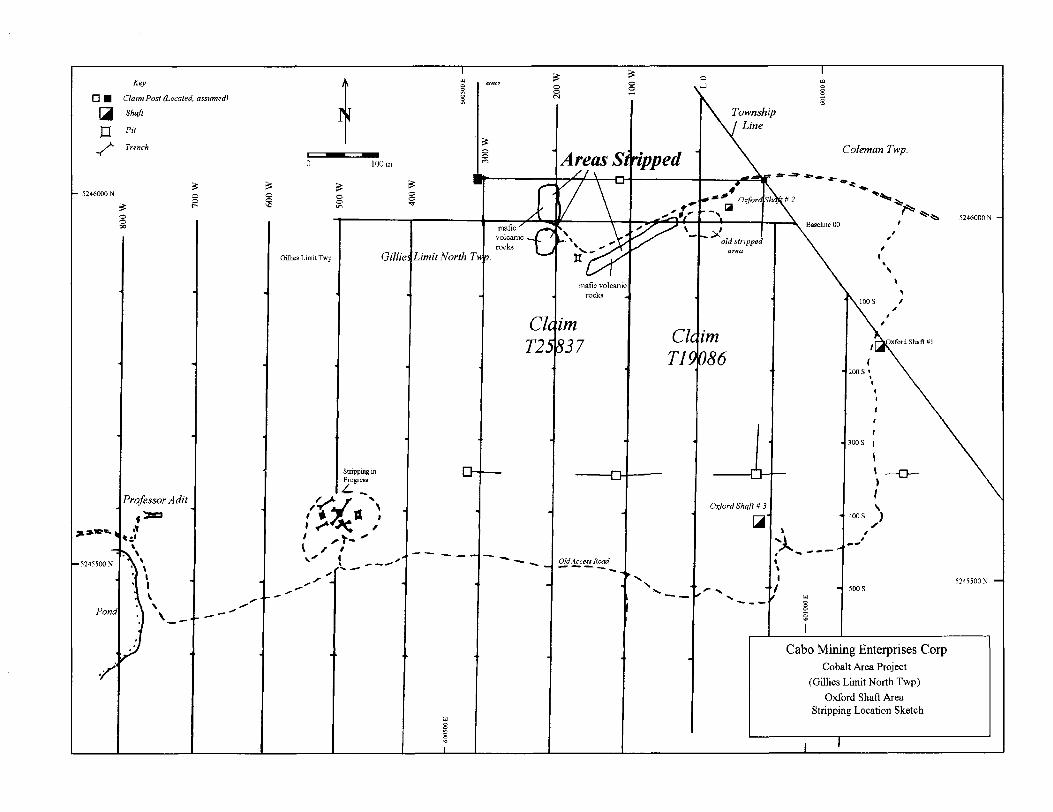
Oxford Shafts Prospect: Three different areas located northeast of the Oxford #2 shaft were stripped.
Claim T19086 (patent); 520 square metres.Claim T25837 (patent); 435 square metres
Access to the Oxford shaft is via the Coleman Road that departs eastwards from Highway 11A at the south western end of the town of Cobalt for 2.5 km to the May fair Mine road, hence for l km and then turning westward along an old overgrown bush access road for approximately l .2 km.
Vegetation in the area consists mostly of sparse hardwood, minor mixed forest and dense underbrush. Topography is rolling with local steep ledges and cliffs. Drainage is generally northwards ultimately into minor streams that flow into Giroux Lake.
GEOLOGY
The area is located in the southern part of the Cobalt mining camp. The area is underlain by Archean massive to pillowed mafic meta-volcanic rocks, local Huronian sediments and Nipissing diabase sills. The immediate area of the stripping there is underlain by mafic volcanic rocks that are very close to an underlying Nipissing aged diabase sill.

Manitoba
Cabo Mining Enterprises Corp
Cobalt Area Project
Cabo Mining Enterprises Corp. Cobalt Area Project
Sears, Barry 4 Associates Limited
Figure 1: Regional Location Map of Ontario

S99000E 60IOOOET45331 l.
Cabo Mining Enterprises CorpClaim Map Showing
Oxford Shall AreaStripping Program November 2004
524800W
524TOOON
524BOOON
988000E BOOOOOEC1000 ' 1247788^
6Q1000E
UTMZono 17 1000m and

Previous Work:
The Oxford area was explored in the early 1900's by three shallow shafts. A small stripping program was carried out in the area of all 3 shafts by Cabo in July of 2004 (Sears, 2004).
Work Program
The work program consisted of a total of 955 square metres of stripping. Manual stripping was completed on key areas within the exposed rock in order to determine the general geology. All of the trenches have rubble and mud covering the detailed geological features. A washing program is currently in progress. The areas will be washed and mapped in detail and channel sampled if warranted.
The only rocks observed in the stripped areaaas were mafic volcanic rocks containing varying amounts of narrow calcite filled fractures
A preliminary map of the areas stripped is included as Figure 3.
Conclusions and Recommendations
Stripping of three areas northwest of Oxford Shaft #3 in Gillies Limit North Township has exposed several small calcite-sulphide veins that warrant detailed mapping and sampling. Washing by wajax pump is currently in progress. All areas will be mapped in detail and channel sampled. The results will be filed as soon as completed. If mineralization is encouraging, a drill program will be required to follow up on this work program.
Respectfully submitted,
Seymour M. Sears, P.Geo.

REFERENCES
Ontario Geological Survey2000: Airborne magnetic and electromagnetic surveys, Temagami area; Ontario Geological
Survey, Map 82 066, scale 1:20 000.
Sears, S.M.2000: Report on a 1999 Drill Program in the Cobalt Area, for Cabo Mining Corp. (Includes
2 holes under the Waldman Prospect and 2 in the Cummings Pits area).
2004: Report on a Stripping Program in Gillies Limit North Area (Waldman, Cummings Pit & Oxford Areas), Assessment Report for Cabo Mining Corp.
Sergiades, A. O.1968: Silver Cobalt Calcite Vein Deposits of Ontario; Ontario Department of Mines,
Mineral Resources Circular No. 10.
Thompson, R.1961: Preliminary Report on parts of Coleman Township, Concession IV, Lots l to 5 and
Gillies Limit, the Eastern "A" Claims, District of Timiskaming; Ontario Department of Mines, P.R. 1961-6.
1963: Cobalt Silver Area, Southwestern Sheet; Ontario Department of Mines Map 2051, Scale 1:12,000.
Assessment Files of the Ontario Geological Survey, Larder Lake Office.
Key
Claim Post (Located, assumed)
Shaft
J3 Pit
j*- Trench
Pond
Gillies Limit Twp Gilli
Stripping in Progress
Township Line
C/72.5 c/
Coleman Twp.
'**
5246000N -
Cabo Mining Enterprises CorpCobalt Area Project
(Gillies Limit North Twp)Oxford Shaft Area
Stripping Location Sketch

ONTMIO MINISTRY OF NORTHERN DEVELOPMENT AND MINES
Transaction No:
Recording Date:
Approval Date:
W0480.01822
2004-NOV-22
2004-NOV-25
Work Report Summary
Status: APPROVED
Work Done from: 2004-NOV-10
to: 2004-NOV-22
Client(s):
120393
392653
Survey Type(s):
CONSOLIDATED PROFESSOR MINES LIMITED
CABO MINING ENTERPRISES CORP.
PSTRIP
Work Report Details:
Claim*
G 8080075
G 8080084
L 1225720
Perform
32,022
32,470
SO
Perform Approve
S2.022
S2.470
SO
Applied
SO
SO
S3,200
Applied Approve
SO
SO
S3.200
Assign
S730
S2.470
SO
Assign Approve
730
2,470
0
Reserve
S1.292
SO
SO
Reserve Approve
51,292
SO
SO
Due Date
SO 2005-SEP-22
S4.492 S4.492 S3.200 S3.200 S3.200 S3.200 S 1,292 51,292
External Credits:
Reserve:
SO
51,292 Reserve of Work Report*: W0480.01822
S1.292 Total Remaining
Status of claim is based on information currently on record.
31M05SE2074 2.28813 GILLIES LIMIT 900
2004-Dec-02 13:19 ARMSTRONG! Page 1 of 1

Ministry ofNorthern Developmentand Mines
Date: 2004-NOV-26
Ministere du Developpement du Nord et des Mines Ontario
GEOSCIENCE ASSESSMENT OFFICE 933 RAMSEY LAKE ROAD, 6th FLOOR SUDBURY, ONTARIO P3E 6B5
CABO MINING ENTERPRISES CORP. 595 HOWE STREET, SUITE 502 VANCOUVER, BRITISH COLUMBIA V6C 2T5 CANADA
Tel: (888)415-9845 Fax:(877)670-1555
Dear Sir or Madam
Submission Number: 2.28813 Transaction Number(s): W0480.01822
Subject: Approval of Assessment Work
We have approved your Assessment Work Submission with the above noted Transaction Number(s). The attached Work Report Summary indicates the results of the approval.
At the discretion of the Ministry, the assessment work performed on the mining lands noted in this work report may be subject to inspection and/or investigation at any time.
If you have any question regarding this correspondence, please contact STEVEN BENETEAU by email at [email protected] or by phone at (705) 670-5855.
Yours Sincerely,
Ron C. Gashinski
Senior Manager, Mining Lands Section
Cc: Resident Geologist
Consolidated Professor Mines Limited (Claim Holder)
Assessment File Library
Seymour M Sears (Agent)
Cabo Mining Enterprises Corp. (Claim Holder)
Cabo Mining Enterprises Corp. (Assessment Office)
Visit our website at http://www.gov.on.ca/MNDM/LANDS/mlsmnpge.htm Page: 1 Correspondence ID:20077

MINISTRYOF NORTHMIN - -. . . , —.T AND MINIS Mining Land Tenure
CANADA HIOVINCIM. IMNINO RECORDER'6 OFFICE Map
602000E 603000E 604000E
5248000N
5247000N
5246000N
5246000N
5243000N
UTM Zone 17 1000m grid
/\^\ l'
524800ON
B247000N
5246000N
B246000N
5244000N "\S X, 5244000N
598000E
^^4,.^^^^.^.^^^—" : s- " -xlt (^21^335 fL9S?|1S'^ f~"*"" Y\,~"-""""
BOOOOOE' " 'eoioooE v
/5S43000N
602000E 603000E
/""
604000E
Date l Time of Issue; Thu Dec 02 16:18:16 EST 2004
TOWNSHIP l AREA PLAN GILLIES LIMIT NORTH 6-3429
ADMINISTRATIVE DISTRICTS t DIVISIONSMining DivisionLand Titles/Registry DivisionMinistry of Natural Resources District
Larder Lake TIMISKAMING NORTH BAY
TOPOGRAPHIC
l Administrative Boundaries
j l Township
! Concession, lot
i i Provincial ParkL ......i
i[||| Indian Reserve
i"": Cliff, Pit S plte
B
a\
Contour
Mine Shafts
Mine Headframe
Railway
Road
Trail
Natural Gal Pipeline
Utilities
Tower
Land Tenure
rreehrjid Patent
1,1 Surface And Mining Rights
f" gl Surface Rights Onty
nn Mining Rights Only
Leasehold Patent
r^l Surface And MWng Rights
["^1 Surface Rights Only
Tgl Mining Rights Only
Licence of Occupation
nn Uses Not Specified
nn Surface And Mining Rights
: A l Surface Rights Only
["^1 Mining Rights Only
! lr , l Land Use Permit
C^l Order In Council (Not open for staking)
pul Water Power Lease Agreement
Mining Claim
Filed Only Mining Claims
LAND TENURE WITHDRAWALS~"——l1234 Areas Withdrawn from Disposition
Mining Acts Withdrawal Types Wsm Surfec* And Mining Rtgnti VWhorewn We Surf** RlahB Only wiMnmn Wm Mining Righto Only WHhdrtwn
Order In Cound Withdrawal Types WVn SurtKt Ana Mining Right! WWrewn Was Swtac* Right* Only WltulrkWR W" m Mining Rights Only Wllhdremn
ULJ IMPORTANT NOTICES
LAND TENURE WITHDRAWAL DESCRIPTIONSIdentifier Type Date Description
Wsm M 10, 2001 ' - DISCREPANCIES IN TOWNSHIP FABRIC - Claim staking In these townships must be done according to the Staking Regulation, for stakir surveyed territory.
4654 Wsm Jan 1,2001 400 FT SURFACE RIGHTS RESERVATION ALONG THE SHORES OfLAKES 4 RIVERS
W-L-OS-03 Wsm Feb 6,2003 Sec. 35 W-L-09-03 M+S 2003/02/06 195150
-y of Northern Development and Mines for additional General Information and Limitations d title determination purposes as the Information Contact Information: onal Information may also be obtained through the
me of downloading from the Ministry of Northern
This map may not show unregistered land tenure and Interests inToll Free Map Datum: NAD 83 l8nd including certain patents, leases, easements, rioht of ways,
Provincial Mining Recorders' Office Tel! 1 (888) 415-8645 ext B7*te|ectlon: UTM (6 degree) flooding rights, licences, or other forms of disposition of rights and Willet Green Miller Centre 933 Ramsey Lake Road Fax: 1 (877) 670-1444 Topographic Data Source: Land Information Ontario Interest from the Crown. Also certain land tenure and land uses Sudbury ON P3E BBS Mining Land Tenure Source: Provincial Mining Recorders' Office *at f*8"1"* w Prohibit free entry to stake mining dalms may not be Home Page: www.mndm.gov.on.ci/MNDM/MINES/LANDS/mlsmnpge.htm Illustrated.
31M05SE2074 2.28813 GILLIES LIMIT 200


![RPT ON MANUAL STRIPPING TECK TP · exposure", apparently averaging 0.10 over the length, with one weighted [chip] sample averaging 0.22/10.5'. Several phases of diamond drilling in](https://static.fdocuments.in/doc/165x107/5e362be2ad53355e97505235/rpt-on-manual-stripping-teck-tp-exposure-apparently-averaging-010-over-the.jpg)


