RPT ON A GCHEM SUR (SOILS) IN THE METCALFE L AREA
27
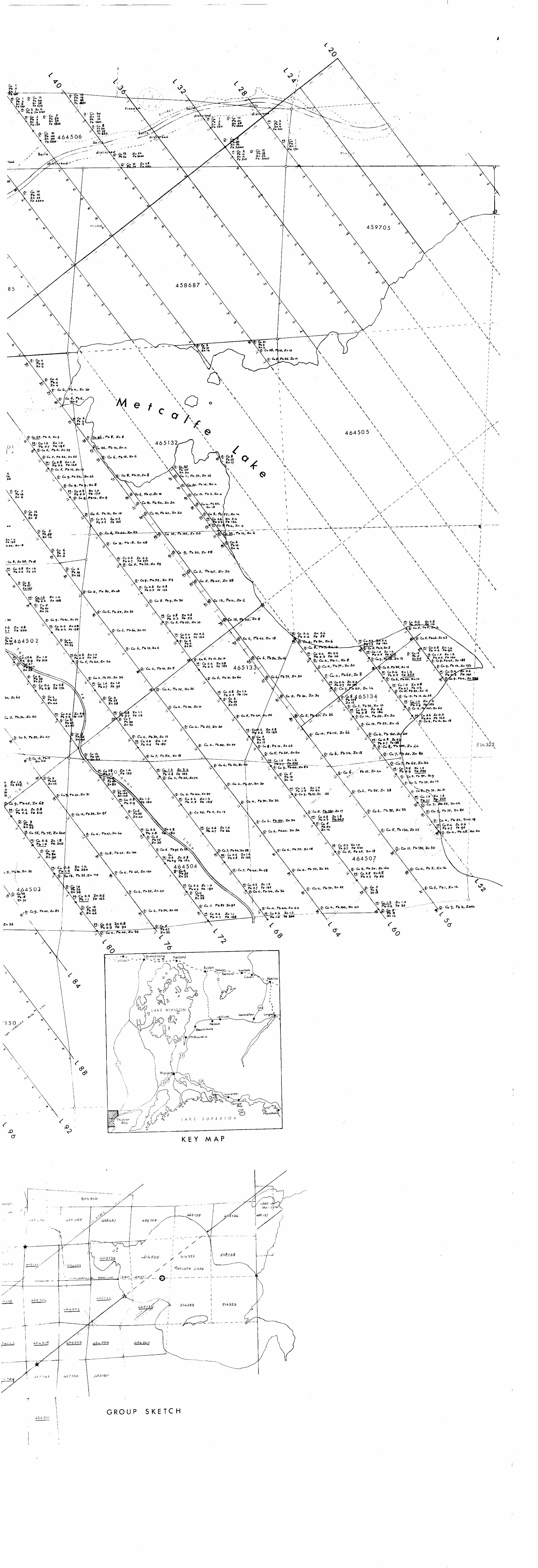
C- 6, ft * J, 464502 M: Ca 0-4 Z* L 0-5 F* '70 : Cu 6 A K E N l P J GO N L A K L T SUPER' OP KEY MAP GC4S-ML GEOCHEMICAL (Soils! . -, : xtMu o sketCn METCALFE LAKE AREA M 1*08 Thunder Bay Mining holder Walter Yzerdroa* asel i n es Traverse lines | ineSi actual, and ^o'rne'r'poii "or witness post Claim line: assumed or submerged Former corner post Survey monument Primary magnetic base station Secondary base Tert iary base lements in parts per million Base map: Walter Y,o,draa, 1980 Trace e M: Mineral soil (DTPA extraction) O; Organic soil (Incineration method) 7*7 sampling points, s6z samples Field work: October l^5i until Aug/Sep 1983 GROUP SKETCH 42L04NE0178 2.629B METCALFE LAKE
Transcript of RPT ON A GCHEM SUR (SOILS) IN THE METCALFE L AREA

C- 6, ft * J,
464502
M: Ca 0-4 Z* L0-5 F* '70
: Cu 6
A K E N l P J GO N
L A K LT SUPER' OP
KEY MAP
GC4S-MLGEOCHEMICAL (Soils!
. -, : xtMu o sketCn
METCALFE LAKE AREA M 1*08
Thunder Bay Mining
holder Walter Yzerdroa*
asel i n es
Traverse lines
| ineSi actual, and^o'rne'r'poii "or witness post
Claim line: assumed or submerged
Former corner post
Survey monument
Primary magnetic base station
Secondary base
Tert iary base
lements in parts per million
Base map: Walter Y,o,draa, 1980
Trace e
M: Mineral soil (DTPA extraction)O; Organic soil (Incineration method)
7*7 sampling points, s6z samples
Field work: October l^5i untilAug/Sep 1983
GROUP SKETCH
42L04NE0178 2.629B METCALFE LAKE
m

42L*4NE8179 2.6398 METCALFE LAKE 010

r .v GC4S-ML(X* l w-ttREPORT ON A GEOCHEMICAL SURVEY (SOILS)
IN THE METCALFE LAKE AREA
Thunder Bay Mining Division
by
Walter Yzerdraat
THE FOURTEEN CLAIMS covered by this survey, TB 464501-02-03-04-
07-08-09-10; TB 465131-32-33-34-38, and TB 514065, form the
central, western, and southwestern portion of the 32 older
claims of a group of 38 claims recorded in the name of the
author and situated in the area of Metcalfe Lake. The soil
survey on these older claims is now almost complete: all the
field work has been done, and one more report is due on four
claims in the northeastern corner of the group. With that
report, we hope to submit some specific conclusions on the
geochemical soil survey as a whole. The present report, in
that department, will be confined to some general recommen
dations and a few details.
LOCATION AND ACCESS
THE CLAIM GROUP lies between the Oboshkegan township line as
it runs between Metcalfe Lake and an esker lake generally known as Lake-on-the-Line, and North Brennan Lake in the southwest,
around which latter small lake the younger six claims are
grouped. Metcalfe Lake is at 50O 9* latitude north and 87O 38*
longitude west. It can now be reached by road from the northern
branch of the Trans-Canada Highway (Route 11) by turning north
at a point some 7 km east of Jellicoe.
It is also possible to reach the property by walking south
from the VIA-Rail Transcontinental line, starting at the Gravel
Pit spur line one mile east of the former railway town of Tashota.
Finally, where cost is no consideration, one can fly into
Metcalfe Lake by chartered bush plane from Jellicoe or Nakina.

GS4S-ML, page 2
GENERAL GEOLOGY
THIS SUBJECT has been dealt with in several reports by this
author; one of the fairly recent official publications is OGS
Report 167, Geology of the Tashota Area, District of Thunder
Bay, by S. E. Amukun (1977); older ODM or OBM reports, such
as those by P. E. Hopkins (1916-1917), T. L. Gledhill (1925)
and L. F. Kindle (1931) contain much interesting and useful
information; a minor (and peculiarly North-American) drawback
to perusing them is the fact that many names have been changed
(Whitefish Lake, Cross Lake and Conglomerate Lake among them)
and that several places (Ombabika, Penequani) no longer exist.
In brief, we can state that the Metcalfe Lake area is part
of an Archaean greenstone (i.e. metavolcanic-metasedimentary)
belt, currently considered as part of the Wabigoon system, and
that land forms reflect the effects of recent glaciations: a
peneplain traversed by eskers, dotted with drumlins and lakes,
and generally poorly drained.
Volcanic rock types range from tholeiitic basalts and ande-
sitic lavas (frequently seen as pillow structures), andesitic
tuffs and flows, and dacite-rhyolite flows or tuffs, to felsic
rhyolite. The pile is metamorphosed to the greenschist facies
(occasionally to amphibolite), interspersed with metasediments
derived from it (locally well-marked by Iron Formation horizons)
and intruded by felsic batholiths and dikes of much younger age.
ECONOMIC GEOLOGY
THE GENERAL AREA is considered to have gold potential. Small
workings were common in the twenties, and the older reports
describe them in detail. Most of the showings and small finds
are in two belts: one extending due north from McDonough and
Metcalfe Lakes, and the other extending due east from the same
lakes. Exploration activity, after having died down in the
late thirties, resumed after the gold price started rising to
its present level.
GC4S-ML, page 3
So far, no major discoveries have been made, but the same thing could, at one time or another, be said for several areas
which now figure prominently as gold camps or 'hot prospects' in geological settings not unlike that of Metcalfe Lake.
THE SURVEY
THIS LATEST geochemical survey is an important chapter in an
overall exploration program started by the author in the mid-
seventies. All the field work has been done as far as legally acceptable assessment work is concerned, but if time permits, more work will be done on those claims for which no more assess
ment credit is available under the present rules. The ultimate aim is the execution of a pilot drilling program which may or
may not be followed by a larger-scale program.
All accessible stations on the fourteen claims concerned
were visited. They lie on grid lines cut at a 100-metre spacing in a direction 36 degrees west of north, and the standard sta
tion interval is 25 metres. The rationale of the grid, and some
technical details about its execution in the late seventies, are described in earlier technical reports by this author.
The map legend states that there were 727 sampling points and
that the survey is based on 562 samples; it is evident, therefore, that a number of samples were left in abeyance. The author and his helpers actually collected far more soil samples than there
are stations.
The fourteen claims traversed have, at least on the map, 779 dry stations, but for various reasons not all of these are suit
able as soil sampling points. Swampy terrain, flooded areas,
and bare outcrop may make it difficult or impossible to collect
soil, especially on soir.e of the northern or extreme-southern claims. The triangle of "land* on the north shore of the West
Arm of Metcalfe Lake, near the northernmost of the small islands, is a case in point, as are the low-numbered stations on lines
112 and 116 on claim TB 464510, which are semi-permanently flooded,
while elsewhere, and particularly on claim TB 465131, nothing but

GC4S-ML, page 4
massive outcrop can be found within ten metres of certain stand
ard grid stations. These facts reduce the number of suitable
soil sampling points somewhat. Of course, one can always
collect vegetation or rock specimens (as we have actually done),
but that type of material does not fit into a pedological survey.
A further reduction in suitable sampling points was recently
caused by human activity. Abitibi-Price Incorporated built an
access road through the claim group, and in doing so, destroyed
a few kilometres of survey line and wiped out more than fifty
stations - partly by unannounced logging on some of the claims.
A secondary result of this activity was a marked slowdown in our
collecting program: time had to be spent on relocating lines
hidden from sight by piles of aspen and other 'waste 1 , and on
re-chaining or rehabilitating lines that were in good condition
as little as six months before. The follow-up work of the pre
sent survey actually utilized some samples that could not have
been taken a month after we collected them.
At most of the 727 sampling sites now remaining, more than
one soil sample was collected: to the best of my knowledge, we
brought back 677 bags with samples of organic soils, and 448
samples of mineral soil, but it would not have been possible,
in light of the time and resources available for this project,
to process and analyze them all. Hence we selected our work
samples in such a way that there would be, on the average,
thirty organic soils and ten mineral soils for each of the
claims traversed. These numbers indicate that some de-empha
sizing has occurred with regard to the mineral soils.
Having had opportunities to study results of previous, smaller
soil surveys in 1981 and 1983, we found that organic soils are
more representative of the bedrock composition (at least in areas
of shallow overburden) than the mineral soils underneath them.
The main usefulness of the mineral soils is that they may enable
the explorer to make an educated guess as to how much of the
base metal content of plant parts (and, by extension, of the or
ganic matter underneath those plants) may have originated not in
the underlying bedrock, but in the mineral soil which is, in our
area, transported material. (This statement ignores the broader
GC4S-ML, page 5
question of whether a steady-state equilibrium is ever reached
between the compositions of shallow bedrock, mineral soil, plants,
and humic material accumulating between the mineral soils and the
vegetation, taking into account climatic fluctuations, biotur
bation, and forest fires.)
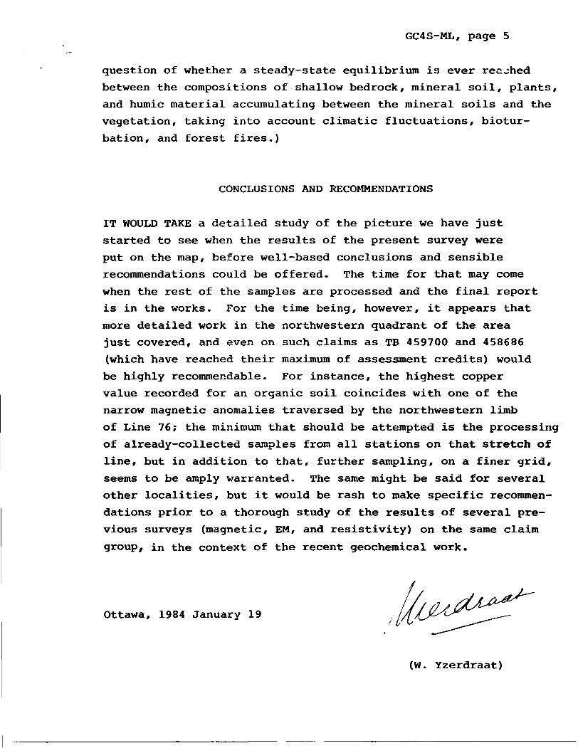
CONCLUSIONS AND RECOMMENDATIONS
IT WOULD TAKE a detailed study of the picture we have just
started to see when the results of the present survey were
put on the map, before well-based conclusions and sensible
recommendations could be offered. The time for that may come
when the rest of the samples are processed and the final report
is in the works. For the time being, however, it appears that
more detailed work in the northwestern quadrant of the area
just covered, and even on such claims as TB 459700 and 458686
(which have reached their maximum of assessment credits) would
be highly recommendable. For instance, the highest copper
value recorded for an organic soil coincides with one of the
narrow magnetic anomalies traversed by the northwestern limb
of Line 76; the minimum that should be attempted is the processing
of already-collected samples from all stations on that stretch of
line, but in addition to that, further sampling, on a finer grid,
seems to be amply warranted. The same might be said for several
other localities, but it would be rash to make specific recommen
dations prior to a thorough study of the results of several pre
vious surveys (magnetic, EM, and resistivity) on the same claim
group, in the context of the recent geochemical work.
Ottawa, 1984 January 19
(W. Yzerdraat)

42L*4NEA17e 2.6298 METCALFE LAKE300
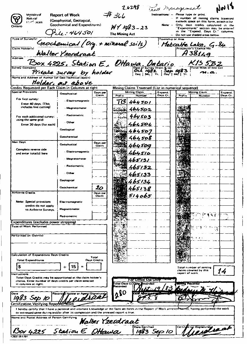
M-nisiryot Report of WorkNatKal
. :rcesOntario
(Geophysical. Geological. Geochemical and Expenditures)
Instructions: Please type or print.If number of mining claims traversed exceeds space on this form, attach a list.
Note' - Only days credits calculated in the "Expenditures" section may be entered in the "Expend. Days O " columns.
- Do not use shaded areas below.
Name and Address of Author (of Geo-Technical report)
Credits Requested per Each Claim in Columns at right Mining Claims Traversed (List in numerical sequence)Special Provisions
For first survey:
Enter 40 days. (This includes line cutting)
Electromagnetic
For each additional survey: , using the same grid:
Enter 20 days (for each)
Complete reverse side and enter total (s) here
Electromagnetic
Airborne Credits
Note: Special provisions
credits do not apply to Airborne Surveys
Electromagnetic
Magnetometer
Radiometric
Expenditures (excludes power stripping)
Total number of mining claims covered by this report of work.
er or Agent (Signature
Certification Verifying RepOrWHWork TO, having performed the workhereby certify that l have a personal and intimate knowledge ot the facts set forth m the Report o 1 Work annex
or witnessed same during and/or after its completion and the annexed report is true.
Marne ants Postal Address of Person Certifying
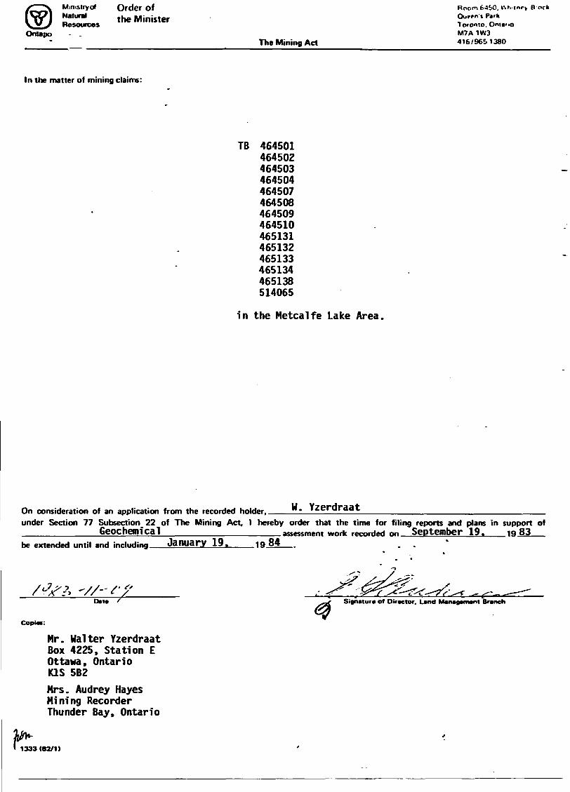
Ministry olNaturalResources
Order of the Minister
OntapoThe Mining Act
Boom 64SO. V\ri.|nrv Bock Ourrn't Park Toronto. Ontario M7A 1W3 416/9651380
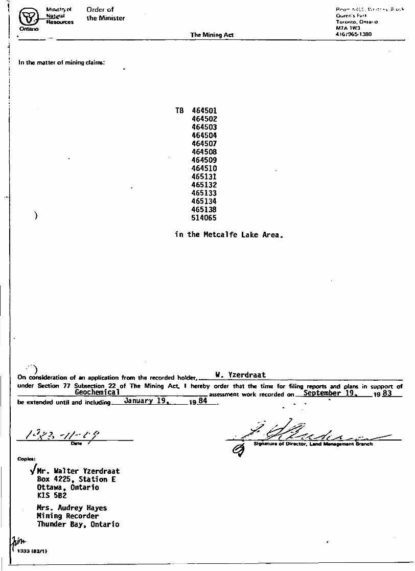
In the matter of mining claims:
TB 464501464502464503464504464507464508464509464510465131465132465133465134465138514065
in the Metcalfe Lake Area.
W. YzerdraatOn consideration of an application from the recorded holder..under Section 77 Subsection 22 of The Mining Act. l hereby order that the time for filing reports and plans in support of_________Geoc henri cal______________assessment work recorded nn September 19. 1 Q 83_be extended until and inrludinrj January 19. i Q 84 . .
Date Signature of Director. Land Management Branch
Copies:
Mr. Walter Yzerdraat Box 4225, Station E Ottawa, Ontario K1S 5B2
Mrs. Audrey Hayes Mining Recorder Thunder Bay, Ontario
1333(82/1)
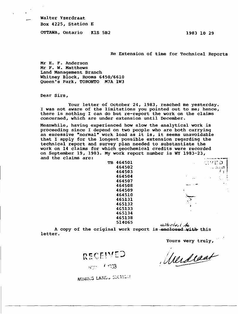
Walter Yzerdraat Box 4225, Station E
OTTAWA, Ontario K1S 5B2 1983 10 29
Re Extension of time for Technical Reports
Mr E. F. Anderson Mr F. W. Matthews Land Management Branch Whitney Block, Rooms 6450/6610 Queen's Park, TORONTO M7A 1W3
Dear Sirs,
Your letter of October 24, 1983, reached me yesterday. I was not aware of the limitations you pointed out to me; hence, there is nothing I can do but re-report the work on the claims concerned, which are under extension until December.
Meanwhile, having experienced how slow the analytical work is proceeding since I depend on two people who are both carrying an excessive "normal" work load as it is, it seems unavoidable that I apply for the longest possible extension regarding the technical report and survey plan needed to substantiate the work on 14 claims for which geochemical credits were recorded on September 19, 1983. My work report number is WY 1983-23, and the claims are: - -, ~~~-
TB 464501 ;''FD464502 :. .:i:;:.cft
464503 f j464504464507464508 ~ "464509464510 ".^^.465131465132 ,4G5133465134465138514065 ,, : . j
iJL-Wz'C/vJ, f sfo
A copy of the original work report is enclosed-vifeh- this letter.
Yours Very truly.
MIMING LAM- GSi
Walter YzerdraatBox 4225, Station EOTTAWA, Ontario '"^ l " -
RECEIVED
K1S 5B2 -af84 February 22-j MIKING LANDS SECTION
Mr J. R. Morton /Your file: 2.6298Acting Director *Land Management BranchRoom 6643, Whitney BlockQueen's Park, TORONTO, OntarioM 7 A l W 3
Dear Mr Morton, *3 L ' ''; J ' ' A'. . .
Your letter of February 10 has been received. It mentions two Reports-of-Work : WY 1983-23 and WY 1983-28. A complete answer requires that I introduce two more Reports- of-Work: WY 1983-27 and WY 1983-29.
All four work reports refer to geochemical surveys, but these fall into two categories. One is that of botanical work, and the other is that of pedological work - the analysis of organic and mineral soils. Thus, as far as your request is concerned, I can indeed confirm that WY 1983-23 and WY 1983-28 refer to two separate surveys , and that they have been substantiated by the submission of two separate technical reports, identified as GC4S-ML and GC7RV-ML, respectively.
To elucidate the identifiers, I would point out that the S in code name GC4S-ML refers to a soil survey (the fourth such survey reported from the claims around Metcalfe Lake - hence the 4 and the ML) , and that the RV in code name GC7RV-ML refers to rock/vegeta tion. In fact, only the first two reports, and the sixth report, in the RV series do include work done on rock samples, but the coding has been maintained for the sake of uniformity.
Listing the four work reports and technical reports in chrono logical order, we have:
Work report Date recorded MD or SP Claims Tech. rep. Due on
WY 1983-23 1983 09 19 MD 14 GC4S-ML 1984 01 19WY 1983-27 1983 12 07 S MD 4 GC5S-ML 1984 02 05WY 1983-28 1983 12 07 SP 11 GC7RV-ML 1984 02 05WY 1983-29 1983 12 13 MD 3 GC8RV-ML 1984 02 11
The only reason why WY 1983-27 (Matched by GC5S-ML) is brought into the picture is the fact that this report was due on the same day as GC7RV-ML (To match WY 1983-28) and that this may have caused compli cations. I packaged the two reports, each in duplicate and accom panied by the prescribed maps, also in duplicate, and took the large enveloppe to Postal Station E for registered mailing on February 6 (the first working day after Friday February 3) . The postal worker on duty informed me that the package weighed more than 500 grams and could not be accepted as first-class mail.
I had to re-package its contents into two separate enve- loppes, which took some time, and then I returned to the post office and mailed those. I am not able to recall whether one or more of the items to be submitted as GC7RV-ML may have been combined with items intended as the submission GC5S-ML, but obviously there could
File 2.6298 1984 02 22 Page 2
be a source of confusion here.The second paragraph of your letter virtually acknowledges receipt of submission GC4S-ML, mailed on January 19; I would merely like to point out a minor discrepancy. Work report WY 1983-23 was sub mitted under the Man-Days rule, but the first paragraph of your letter might suggest that it came under the Special Provisions. As three of the fourteen claims (TB 465132-33-34) are partly sub merged, I had decided to report all fourteen claims under the Man- Days method.There is also the possible impression that work report WY 1983-28 refers to the same 14 claims as WY 1983-23 (your letter gives a listing which is correct for WY 1983-23), whereas in fact the three partially-submerged claims TB 465132 et al are not included in work report WY 1983-28. Hence the technical report, GC7RV-ML, covers only the remaining eleven claims which contain no land under water, and the work report 1983-28 was submitted under Special Provisions, not man-days as your letter might imply.
The three partially-submerged claims TB 465132-33-34 are the subject of another botanical report, under the Man-Days method, namely GC8RV-ML, matching work report WY 1983-29, and mailed the day after your letter was written.
A further possible, but unlikely, source of confusion is the fact that the claims were transferred to another party on January 9 or January 10, but this fact is mentioned on the Technical Data State ment.
Your request for new maps and reports of GC7RV-ML (matching WY 1983- 28) will take a few days to satisfy. I have already phoned the person in Brockville who has the last remaining copy of the report, and the maps can only be printed after I order and receive a new roll of printing paper from Norman Wade in Kanata.
This map, meanwhile, has been updated in two ways. In the first place, the values for GC8RV-ML have been added to the master copy and the legend has been altered to reflect the particulars of the latter report. I will have to change that back to GC7RV-ML on the prints.
The sffiond change is an improvement. When I received the tape with the output of the last AA run, containing several dozens of values to be incorporated into both GC5S-ML and GC7RV-ML, I was informed that the machine had been unreliable during part of the run, and would probably need replacement of some parts. As soon as the instrument would be in working order again, presumably before the 3rd of February, my last batch of sample solutions would be run again. However, when Friday the third came around, the machine was still down, and I had to use the values as shown on the tape.
The next week, my samples were re-run and I received another output tape. When recalculating the ppm values in the samples as such, it turned out that the previous run had given generally much lower zinc results, and that some significant lead values had been missed. Consequently, I updated the master copy, and when studying the prints sent to Toronto for GC8RV-ML, you may notice that for several stations on Lines 100 to 112 new, and generally higher, trace element values have been inserted.
The new prints will, therefore, also show these upgraded
Your file 2.6298 1984 02 22 Page 3
values, and it would be recommendable to discard, or return to me, any copies of the old map GC7RV-ML that might as yet turn up in your office.
Yours very truly,
cc: 519899 Ontario Limited, BrockvilleKingston
Mining Recorder, Thunder Bay
Our File: 2.6298 February 10, 1984.
Mr. Walter Yzerdraat Box 4225 Station E Ottawa, Ontario K1S 582
Dear Sir:
RE: Geochemlcal Survey submitted on Mining CIaIBS TB 464501 et al In the Area of Metcalfe Lake.———————————
He have received two Reports of Work for Geochemical Surveys carried out on Mining Claims TB 464501 to 04 Inclusive, TB 464507 to 10 Inclusive. TB 465131 to 34 Inclusive, TB 465138 and TB 514065. The first Report of Work dated September 19, 1983 has recorded 20 days Geochemlcal under Special Provisions (credit for Performance and Coverage), while the second Report of Work dated December 7, 1983 has recorded 20 days Geochemlcal under mm days.
He have received reports and maps for the first survey HY 1983 - 23 but have not received any reports for the second survey HY 1983 - 28, Could you please send In a copy of the reports and maps Matching the survey MY 1983-28, confirming that two separate surveys have actually been completed.
For further Information, please contact Mr. F. M. Matthews at (416) 965-1380
Yours very truly.
j. R. MortonActing DirectorLand Management Branch
Whitney Block, Room 6643Queen's ParkToronto. OntarioM7A 1W3Phone: 416 (965-1380))
M. E. Anderson:dg
cc: Mining RecorderThunder Bay, Ontario.

Walter Yzerdraat Box 4225, Station E OTTAWA, Ontario K l S 5 B 2
Mr J. R. Morton Acting Director Land Management Branch Whitney Block, Room 6643 Queen's Park, TORONTO
l RECEIVED' land ManafMmnt Branch', c. g
f E& 7 :?84
1984 February 3
U. 3OOD
Your File: 2.6298
Dear Mr Morton, .. .
From the courtesy copy of the letter you sentto the Recorder in Thunder Bay on January 26, it appears that a copy of a certain work report went missing.
This is my work report WY 1983-23, dated 1983 September 10, recorded in Thunder Bay on September 19 under 1366, Mining Recorder's File 464501. It concerned a geochemical (soil) survey on 14 claims in the Metcalfe Lake Area. A copy of the recorded report was received in your office on October 12, 1983, and a copy of that copy was attached to the Ministerial Order signed on November 11 by Mr Anderson, allowing an extension of time for filing the technical report until and including January 19, 1984.
Hoping that it may facilitate matters, I am returning to you the copy I received with the Order of the Minister.
Another copy of the same work report, perhaps with less filing information on it, was enclosed with my latest technical report on the soil survey in question.
Yours very truly,
cc: Mrs Audrey M. Hayes Thunder Bay
Ffi-
MININ
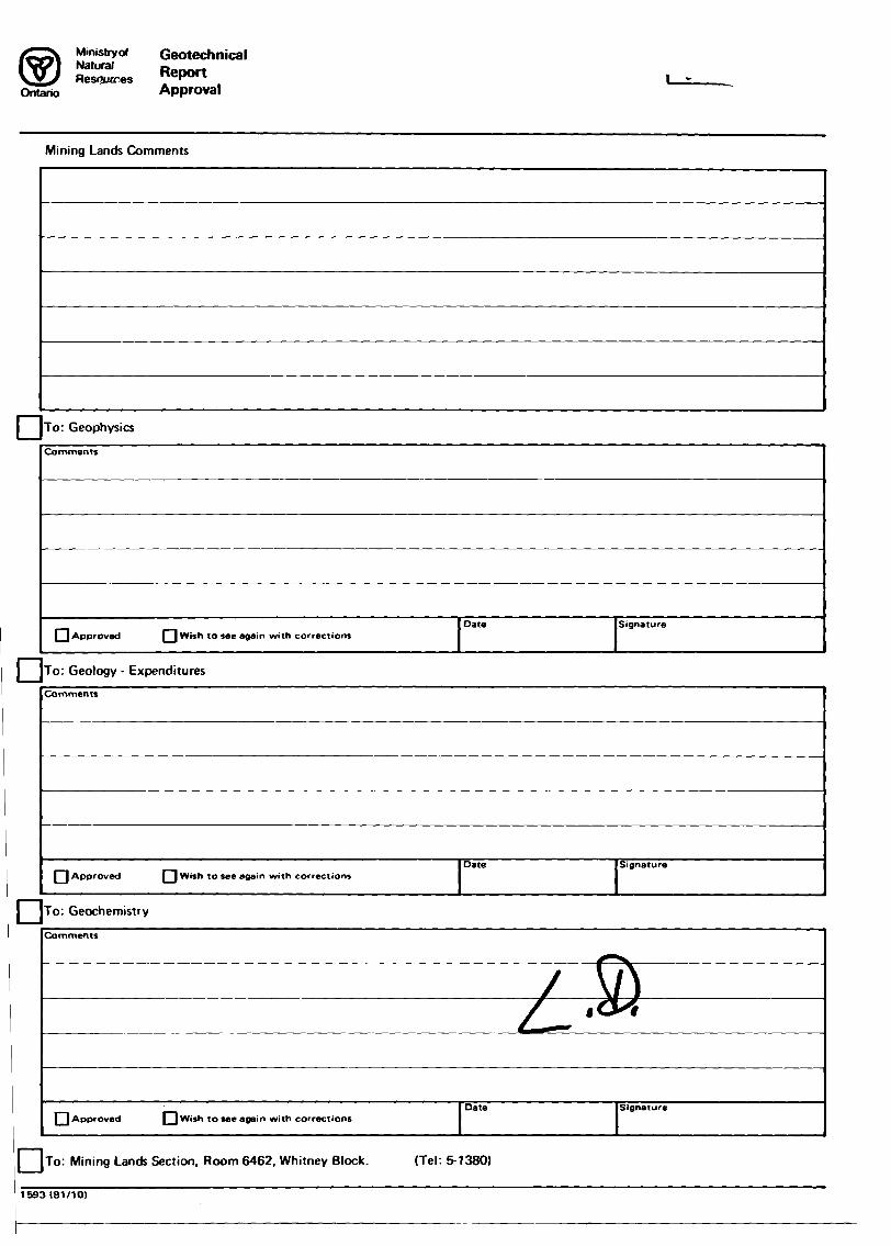
Mimstryof GeotechnicalNatural RpnortRes^wres "epwt
Ontario Approvall -
Mining Lands Comments
D To: Geophysics
Comments
Approved Q Wish to see again with correctionsDate Signature
To: Geology - Expenditures
Comments
l l Approved [~] Wish to see again with correctionsDate Signature
To: Geochemistry
Comments
[ l Approved D Wish to see again with correctionsDate Signature
l j To: Mining Lands Section, Room 6462, Whitney Block. (Tel: 5-1380)
1593 (81/10)

1964 01 26 Tour File: 366
Our File : 2.6298
Mrs. Audrey HayesMining RecorderMinistry of Natural ResourcesP.O. Box 5000Thunder Bay, OntarioP7C 5G6
Dear Madam:
He have received reports and maps for a Geochemical Survey subBltted on Mining CIaIBS TB 464501 et al In the Area of Hetcalf Lake.
This Material will be examined and assessed and a statement of assessment work credits will be Issued.
Me do not have a copy of the report of work which 1s normally filed with you prior to the submission of this technical data. Please forward a copy as sonn as possible,
Tours very truly,
J.R. MortonActing DirectorLand Management Branch
Whitney Block, Room 6643Queen's ParkToronto, OntarioM7A 1U3Phone: 416/965-1380
A. Barr:sc
cc: Mr. Halter Tzerdraat Box 4225 Station E Ottawa, Ontario US 5B2

Approved Reports of Work sent out
Notice of Intent filed
Approval after Notice of Intent sent out
Duplicate sent to Resident Geologist
Duplicate sent to A.F.R.O.
i.
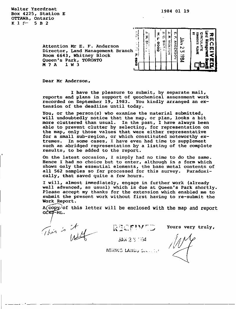
Walter Yzerdraat Box 4225, Station E OTTAWA, Ontario K l f- 5 B 2
1984 01 19
Attention Mr E. F. Anderson ."l Director, Land Management Branch ; | Room 6643, Whitney Block ?' Queen's Park, TORONTO S M 7 A l W 3
i 0 ^8'J! *-:
m
00
s? s m * *~* bk ^^" C 2 O3 J(sm
x n
S m S ''i8 15
Dear Mr Anderson,
I have the pleasure to submit, by separate mail, reports and plans in support of geochemical assessment work recorded on September 19, 1983. You kindly arranged an ex tension of the deadline until today.
You, or the person(s) who examine the material submitted, will undoubtedly notice that the map, or plan, looks a bit more cluttered than usual. In the past, I have always been able to prevent clutter by selecting, for representation on the map, only those values that were either representative for a small sub-region, or which constituted noteworthy ex tremes. In some cases, I have even had time to supplement such an abridged representation by a listing of the complete results, to be added to the report.
On the latest occasion, I simply had no time to do the same. Hence I had no choice but to enter, although in a form which shows only the essential elements, the base metal contents of all 562 samples so far processed for this survey. Paradoxi cally, that saved quite a few hours.
I will, almost immediately, engage in further work (already well advanced, as usual) which is due at Queen's Park shortly. Please accept my thanks for the extension which enabled me to submit the present work without first having to re-submit the Work Report.
of this letter will be enclosed with the map and report
f,k"*, V Yours very truly.
Ontario
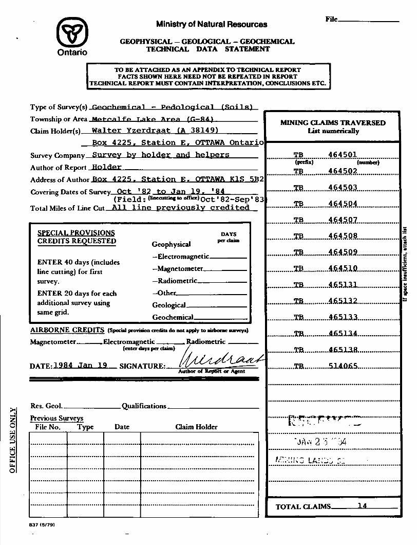
Ministry of Natural Resources
GEOPHYSICAL - GEOLOGICAL - GEOCHEMICAL TECHNICAL DATA STATEMENT
File.
TO BE ATTACHED AS AN APPENDIX TO TECHNICAL REPORTFACTS SHOWN HERE NEED NOT BE REPEATED IN REPORT
TECHNICAL REPORT MUST CONTAIN INTERPRETATION. CONCLUSIONS ETC.
C
tt
a ybb. O
Type of Survey(s) ^^or^hpmi r?a1 — P^Hnlngirral (Soil g) Township or Area Mta-fr-a 1 ft* t,alco A-riaa (fi—ftA)^———^^^^ Claim Hoirfer(s) Walter Yzerdraat (A 38149)-——^—
Box 4225, Station E, OTTAWA Ontario Survey Company Survey by holder and helpers^—^—
Author of Report Holder——-^—^^-.——^-.^——^^^—— Address of Author Box 4225. Station E. OTTAWA KlS 5B2Covering Dates of Survey Oct '82 to Jan 19. '84——-^
(Field: (finecuttins tooffioe)C)ct l 82-Sep I 83 Total Miles of Line rut All line previously credited
SPECIAL PROVISIONS CREDITS REQUESTED
ENTER 40 days (includes line cutting) for first survey.ENTER 20 days for each additional survey using same grid.
Geophysical—Electromagnetic.—Magnetometer——Radiometric———Other————^
DAYS pcrdaim
Geological.
Geochemical.
AIRBORNE CREDITS (Special provision credit! do not apply to uiborae mveyi)
Magnetometer. .Electromagnetic . Radiometric(enter days per claim)
HATF-1984 Jan 19 SIGNATURE:Author
Res. Geol.. . Qualifications.Previous Surveys
File No. Type Date Claim Holder
MINING CLAIMS TRAVERSED List numerically
TB 464501(prefix) (number)
..T.B............46.45.P.2............
.TB............464.5.Q3.
.TB............46.45Q4.
TB............464.5.Q1.
TB..............4.645.Q8..
AArl****a******B*VAr*M**oAw**i
..TB.............4.6.5JL3.3..
.ta,.p^.^Ta-
"JAw 2 '5
i*~ LAN '
TOTAL CLAIMS- 14
837 (5/79)

GEOCHEMICAL SURVEY - PROCEDURE RECORD
Numbers of claims from which samples t^n H25 soil samples (both types) taken from _________________________all fourteen claims listed on front page (TB 464501-02-03-04-07-08-09-10; TB 465131-32-33-34-38; TB 514065)
Total Number of Samples 562 for t h J S report ANALYTICAL METHODSType of Sample 139 mineral; 4?3 nrganir Values expressed in: percent d
(Nature of Material) r r ——
Average Sample Weight TOO g min., ?00 g org. p' |J" ™" QMethod of Collection—Cut cylindrical plug --^ ^^ -~with stainless steel trowel; separate (^u/ (Pby (Zip Ni, Co, Ag, Mo, As.-(circle)horizons, bag in plastic,label with marker.Soil Horizon Sample An +Q AT an* p 9 Others Fe on all mineral and several
Poor to moderate- no 9r9fui ^-ci SO4-1S * the latter not mapped. Horizonn—i^pm^t Foor to moderate, no FlcfdAnalysis ————————————————— tggjr mature protiies touna
Sample Hppth ^—1 n cm; 6—?5 cm (org/min) Extraction Method-^—-—-^-^———.^——.———ivrein F1*t to undulating, locally mod. Analytical Method___________________
to steep esker slope;swamp, musKeg ———or barren outcrop in restriotod areasReagents Used ———————————————————Drainage iv^-Unm^t No Perennial streams; Fidd Laboratory Analysis
stagn. pools to well-dr. slopes.Estimated Range of Overburden THirkru-gg Mostly ^o- (—————————————————————————tests)from 0.5 to 2.5 m; locally much greater Extraction Method——^———-———.—--depths up to 50 m, but also thin soil . . . ,.. . ._____l___________________________ Analytical Method ————————————————————cover and occasional outcrop. ^ ,. ,Reagents Used______________________
SAMPLE PREPARATION Commercial Laboratory ( 1R^*________tests)(Includes drying, screening, crushing, ashing)
.. L - r r - j r i - o n i~t~ ,,~A i \ Namp of I^thrtratnry f!arlf*fr.on Univf*rsit-yMesh size of fraction used for analysis -H (l—l mm. soil) Denartment of BioloovPreparation of ALL samples consists of F.vrrartion M^tTKvgr 1-^"- /"^ 9Yj,__j__ __ ____,__ __ ti n^ __i.. j_ m : n l/TfA/TEAdry inti; scjreemnQ appj-ies on J. y to nun. . ,. ,.. . j.,. t. — _soils: weighing go all f 10 a mineral. Analytical Method At. ahs. sp
0.5 g organic) ; shaking with 20 ml DTPA R^p-nts llsfH Di-ethvl tri-amino pent- for two td three hdurs for mineral; ashing acetic acid (DTPA) and at 550 C for organic; HCl digestion and * tri-ethanol amine (TEA) dilution for organic; settling and fil- General Note re number of tests; theseGcne™-——:———-———:———:——-————i———r 1825 are the final multiple readings
tering for mineral; determination ______,_______. _____lon 139 mineral soils(four ions each)
of non-combustible residue for organic and 4?3 organic anils (frhr^P ions in order to adjust for the actual mass not counting trial runs to determine _____________,___________.____ ppm levels, calibrations, cianxs, and of organic material ashed and digested, determination of ions such as Mn (and—————————————————————————————— Pe in organic soils) which are not
m^^^ji^icsx^^^^l^i ™*————————————————————————————— termination is the average of two orthree multiple roadingo,. .Taking all these as ;tests1 would bring the to-i-piT -t-rt w*a1 T nvgt-r vfltini ._____i_______
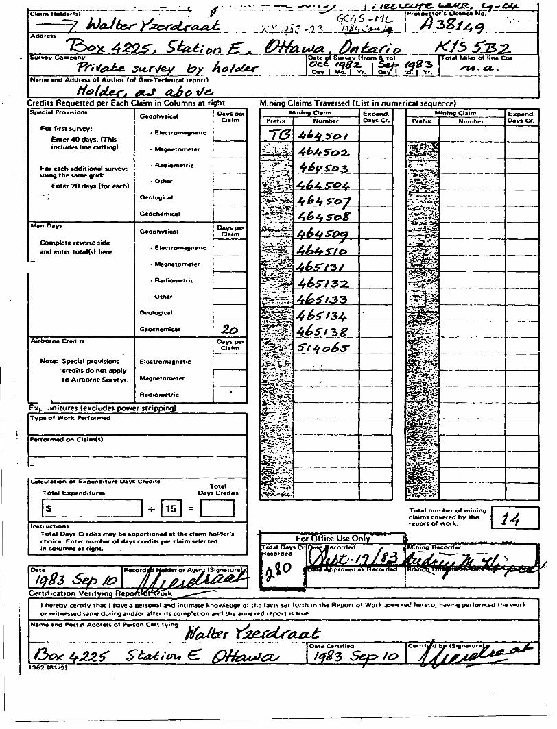
Credits Requested per Each Claim in Columns at rightSpecial Provisions
For first survey:
Enter 40 days. (This includes line cutting)
For each additional survey: ! using the same grid:
Enter 20 days (for each)- l
Geophysical f Days per . Claim
- Electromagnetic '
- Magnetometer -
Man Days
Complete reverse side and enter total(s) here
Airborne Credits
Note: Special provisions credits do not apply to Airborne Surveys.
- Radiometric
-Other
Geological
Geochemical
Geophysical j Day* per i Claim
- ElectromagneTic '
- Magnetometer !
- Radiometric .
- Other
Geological ;
Geochemical '
Days per i Claim
Electromagnetic
Magnetometer
Radiometric
Ex|.-.iditures (excludes power stripping)
Mining Claims Traversed (List in numerical sequence)
Type of Work Performed
Performed on Claim(s)
Calculation of Expenditure Days Credits
Total ExpendituresTotal
Days CreditsliInstructions
Total Days O edits may b* apportioned at the claim holler's choice. Enter number of days credits per claim selected in columns at right.
Mining ClaimPrefix
f**2r
Number
r.-j-
-'"-* 7
f**?-.rHSS-^'
Expand. Days Cr.
Total numoer of mining claims covered by this report of work.
Certification Verifying Reporw5rffl)rlrr
l hereby certify thai l have a personal and intimate knowledge o! :hc lad* set forth m the Rcpoit o* Work annexed hereto, having performed the work or witnessed same during and/or after its comp'eiion and :he annexed report is true.
Narte and Postal Address of Penon Cert.l y ing
1362 (81/0)
Ministry o*NaturalResources
Order of the Minister
OntarioThe Mining Act
Roo~ h-'.ii.. l'.; .: Quecn'i f-^it
Toronto. OnlanO M7A 1W3 416/965-1380
In the matter of mining claims:
TB 464501464502464503464504464507464508464509464510465131465132465133465134465138514065
in the Metcalfe Lake Area.
W. YzerdraatOn consideration of an application from the recorded holder..under Section 77 Subsection 22 of The Mining Act. l hereby order that the time for filing reports and plans in support of_________Geochemical_____________assessment work recorded on September 19. iQ.83__ be extended until and inriiriing January 19. IQ 84 . .
Signature of Director. Land Management Branch
Coptet:
/Mr. Walter Yzerdraat Box 4225, Station E Ottawa, Ontario K1S 5B2Mrs. Audrey Hayes Mining Recorder Thunder Bay, Ontario
1333(82/1)
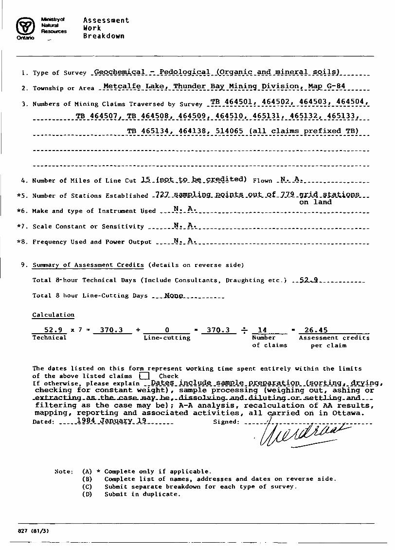
Assessment Natural WorkResources " , JBreakdown
1. Type of Survey .Geochemical.Ji.?edologi.cal
2. Township or Area ..MetcaJLfe.J^H?/.^\??A®?.?^.^I\.^9-PAYi?A5l^ 1.^^.97A4.......
3. Numbers of Mining Claims Traversed by Survey .?.B..164501, 464502, .464503, 464504,
jrB^ej^OS,^^^
TB 465134, 464138, 514065 (all claims prefixed TB)
4. Number of Miles of Line Cut 15.. {not .tO.JDe .credited) Flown .N.r..A ;.
*5. Number of Stations Established -72J..s.amp.l.ing. j3QiniJEL.Qu;t..Qf..7.7.9..gr.i.4.stAJtions...on land
*6. Make and type of Instrument Used . — .^;.A*...........-...............-.................
*7. Scale Constant or Sensitivity .......*!;.A*-....-...---..-..-.-.........--.--......-...-
*8. Frequency Used and Power Output .....N..A-...-....--.--.-.-...-....-...--.-.-..........
9. Summary of Assessment Credits (details on reverse side)
Total 8-hour Technical Days (Include Consultants, Draughting etc.) . . S.2...9.. . .
Total 8 hour Line-Cutting Days ...Hone...........
Calculation
52.9 x 7 ' 370.3 * O 370.3 -r 14 - 26.45Technical Line-cutting Number Assessment credits
of claims per claim
The dates listed on this form represent working time spent entirely within the limitsof the above listed claims j l CheckIf otherwise, please explain ..Dates, ij!clud.e..samp.le.pj:j^arAtion..(.sor^^^ checking for constant weight), sample processing (weighing out, ashing or
.extracting.. as .the. .case. jnay. .he f . dJ-ssoJj&ing. .and- d :* luting .or. jae ttJ-Lng. and filtering as the case may be); A-A analysis, recalculation of AA results, mapping, reporting and associated activities, all carried on in Ottawa.
Dated: ___i??4..January..19.._.. Signed:
Note-. (A) * Complete only if applicable.(B) Complete list of names, addresses and dates on reverse side.(C) Submit separate breakdown for each type of survey.(D) Submit in duplicate.
827 (81/3)

Details of Assessment Work Breakdown
FIELD WORK
Type of Work Name f* Address Dates WorkedNumber of 8 hour days
SampJ-e ̂ collecting_ JV ; . J.^ .Muirhead^ j3 tejAnne^dje^B.^ _ - pctober. .19 62, ........4.."Same work Same helper Aug/Sep 1983 l 5
_.Sanje -wprjc__.pjeter- JBubniw t .pJttawa--___.......... J.un.e. - ...198-3--- ......^..Same "work" Walter""Yzerdraat "ottawa October""l982""" "~~~~2^2 Same wprk^ .Walter Yzerdraat June 1983 2 Same "work "Walter""Yzerdraat Aug/Sep "l983"" " 2" 5....j...™,
j
CONSULTANTS (Sample preparation, processing, analysis)Number of
Name 6c Address Dates Worked (specify in field or office) 8 hour days
-----------------------------------------------------------------------------r----------
W. Yzerdraat, Box 4225, Station E, Ottawa; throughout 1983 and in 2 5
J-ajoe±w -Qcegp.t .Pep... .of. .Biol.-.t .Carletpn. .y. j. .lab. .(AA. analy si.s). .............. I.-.5.David Omond", Dep. of Biology, C.U. lab (AA analysis)__________3.65 DRAUGHTSMAN. TYPING. OTHERS (specify) Sub-total 30.15
Number of Name 6. Address Type of Work Dates Worked 8 hour days
Walter Yzerdraat, Ottawa - Map and report preparation, typing, j iprinting, copying and associated work | 1
TOTAL 8 HOUR TECHNICAL DAYS ____52.9
LINE-CUTTING Not applicable: all line cut for previous surveysNumber of
Name Address Dates Worked 8 hour days
!
.............................................................................I.........J
........J
TOTAL 8 HOUR LINE-CUTTING DAYS None