Royal Guide Cambodia - Amazon Web Services...Song Saa Island (Koh Sang Saa) Description Song Saa...
35
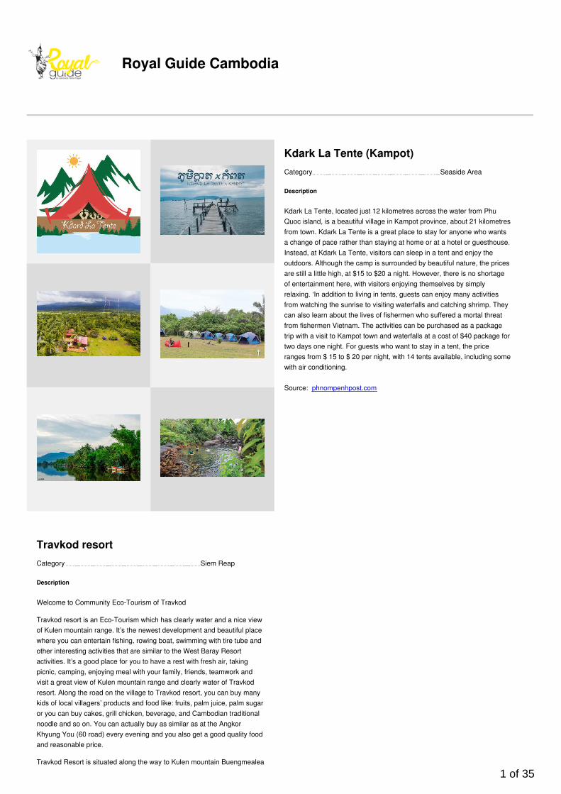
Royal Guide Cambodia Category Seaside Area Kdark La Tente (Kampot) Description Kdark La Tente, located just 12 kilometres across the water from Phu Quoc island, is a beautiful village in Kampot province, about 21 kilometres from town. Kdark La Tente is a great place to stay for anyone who wants a change of pace rather than staying at home or at a hotel or guesthouse. Instead, at Kdark La Tente, visitors can sleep in a tent and enjoy the outdoors. Although the camp is surrounded by beautiful nature, the prices are still a little high, at $15 to $20 a night. However, there is no shortage of entertainment here, with visitors enjoying themselves by simply relaxing. ‘In addition to living in tents, guests can enjoy many activities from watching the sunrise to visiting waterfalls and catching shrimp. They can also learn about the lives of fishermen who suffered a mortal threat from fishermen Vietnam. The activities can be purchased as a package trip with a visit to Kampot town and waterfalls at a cost of $40 package for two days one night. For guests who want to stay in a tent, the price ranges from $ 15 to $ 20 per night, with 14 tents available, including some with air conditioning. Source: phnompenhpost.com Category Siem Reap Travkod resort Description Welcome to Community Eco-Tourism of Travkod Travkod resort is an Eco-Tourism which has clearly water and a nice view of Kulen mountain range. It’s the newest development and beautiful place where you can entertain fishing, rowing boat, swimming with tire tube and other interesting activities that are similar to the West Baray Resort activities. It’s a good place for you to have a rest with fresh air, taking picnic, camping, enjoying meal with your family, friends, teamwork and visit a great view of Kulen mountain range and clearly water of Travkod resort. Along the road on the village to Travkod resort, you can buy many kids of local villagers’ products and food like: fruits, palm juice, palm sugar or you can buy cakes, grill chicken, beverage, and Cambodian traditional noodle and so on. You can actually buy as similar as at the Angkor Khyung You (60 road) every evening and you also get a good quality food and reasonable price. Travkod Resort is situated along the way to Kulen mountain Buengmealea 1 of 35
Transcript of Royal Guide Cambodia - Amazon Web Services...Song Saa Island (Koh Sang Saa) Description Song Saa...
Royal Guide Cambodia
Category Seaside Area
Kdark La Tente (Kampot)
Description
Kdark La Tente, located just 12 kilometres across the water from PhuQuoc island, is a beautiful village in Kampot province, about 21 kilometresfrom town. Kdark La Tente is a great place to stay for anyone who wantsa change of pace rather than staying at home or at a hotel or guesthouse.Instead, at Kdark La Tente, visitors can sleep in a tent and enjoy theoutdoors. Although the camp is surrounded by beautiful nature, the pricesare still a little high, at $15 to $20 a night. However, there is no shortageof entertainment here, with visitors enjoying themselves by simplyrelaxing. ‘In addition to living in tents, guests can enjoy many activitiesfrom watching the sunrise to visiting waterfalls and catching shrimp. Theycan also learn about the lives of fishermen who suffered a mortal threatfrom fishermen Vietnam. The activities can be purchased as a packagetrip with a visit to Kampot town and waterfalls at a cost of $40 package fortwo days one night. For guests who want to stay in a tent, the priceranges from $ 15 to $ 20 per night, with 14 tents available, including somewith air conditioning.
Source: phnompenhpost.com
Category Siem Reap
Travkod resort
Description
Welcome to Community Eco-Tourism of Travkod
Travkod resort is an Eco-Tourism which has clearly water and a nice viewof Kulen mountain range. It’s the newest development and beautiful placewhere you can entertain fishing, rowing boat, swimming with tire tube andother interesting activities that are similar to the West Baray Resortactivities. It’s a good place for you to have a rest with fresh air, takingpicnic, camping, enjoying meal with your family, friends, teamwork andvisit a great view of Kulen mountain range and clearly water of Travkodresort. Along the road on the village to Travkod resort, you can buy manykids of local villagers’ products and food like: fruits, palm juice, palm sugaror you can buy cakes, grill chicken, beverage, and Cambodian traditionalnoodle and so on. You can actually buy as similar as at the AngkorKhyung You (60 road) every evening and you also get a good quality foodand reasonable price.
Travkod Resort is situated along the way to Kulen mountain Buengmealea
1 of 35
and Koshke temples and it is across a way to that temple above. It is 10kilometers nearer than Soutnikum district’s way and this way let all driverscan save their times and money from transportation. Certainly, for hotels,tourists, guides, taxis and Rirmok Association will get more benefit whenwe add Trackod resort and Chaosrey Vibul Ke temple program into theItinerary. It is a new and interesting program that can attract many touriststo spend more longer to stay in Seim Reap town and it also providesmore jobs for farmers in this rural area community and partake to developthis new Eco-Tourism Resort.
Category Seaside Area
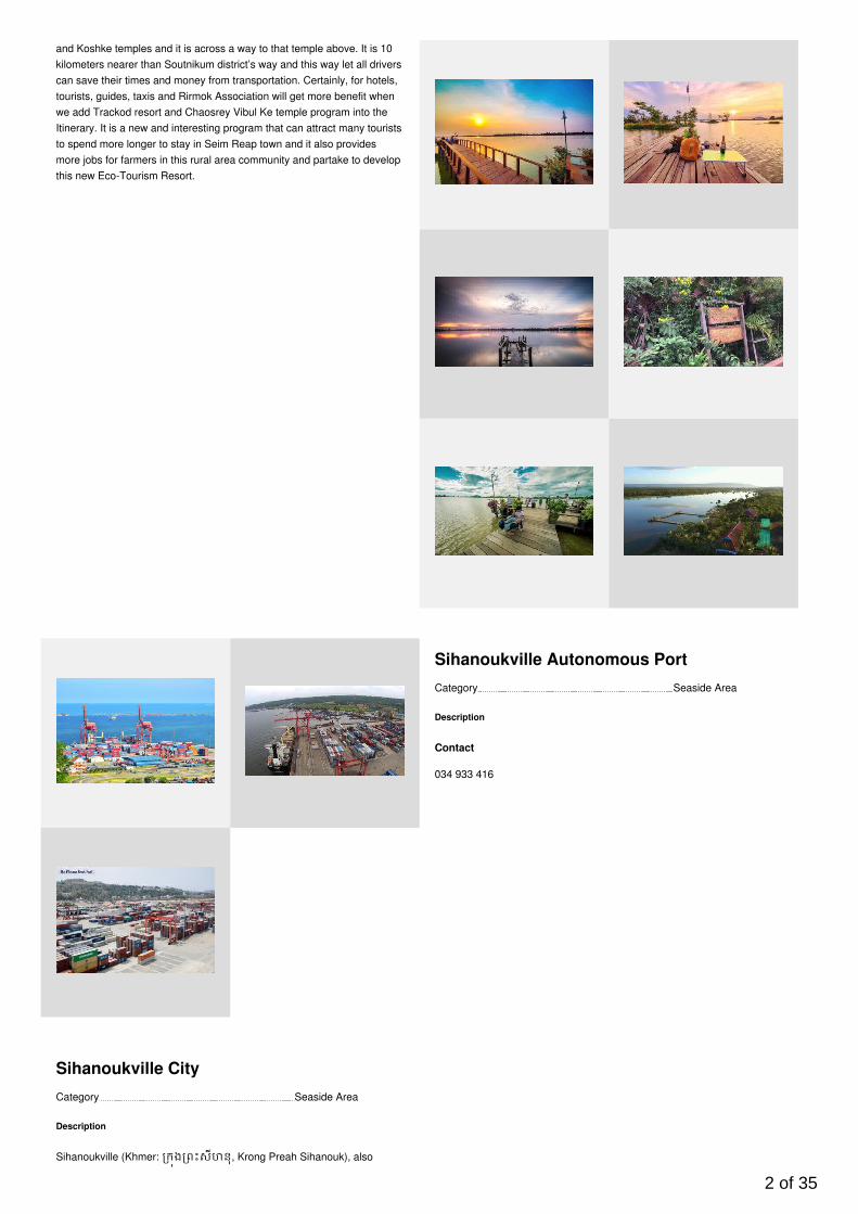
Sihanoukville Autonomous Port
Description
Contact
034 933 416
Category Seaside Area
Sihanoukville City
Description
Sihanoukville (Khmer: កង ពះសីហនុ, Krong Preah Sihanouk), also
2 of 35
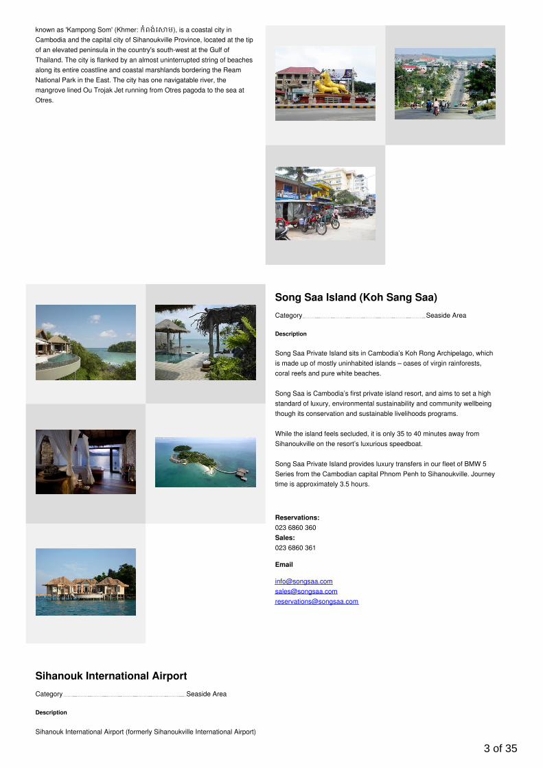
known as 'Kampong Som' (Khmer: កំពង់េ ម), is a coastal city inCambodia and the capital city of Sihanoukville Province, located at the tipof an elevated peninsula in the country's south-west at the Gulf ofThailand. The city is flanked by an almost uninterrupted string of beachesalong its entire coastline and coastal marshlands bordering the ReamNational Park in the East. The city has one navigatable river, themangrove lined Ou Trojak Jet running from Otres pagoda to the sea atOtres.
Category Seaside Area
Song Saa Island (Koh Sang Saa)
Description
Song Saa Private Island sits in Cambodia’s Koh Rong Archipelago, whichis made up of mostly uninhabited islands – oases of virgin rainforests,coral reefs and pure white beaches.
Song Saa is Cambodia’s first private island resort, and aims to set a highstandard of luxury, environmental sustainability and community wellbeingthough its conservation and sustainable livelihoods programs.
While the island feels secluded, it is only 35 to 40 minutes away fromSihanoukville on the resort’s luxurious speedboat.
Song Saa Private Island provides luxury transfers in our fleet of BMW 5Series from the Cambodian capital Phnom Penh to Sihanoukville. Journeytime is approximately 3.5 hours.
Reservations:023 6860 360Sales:023 6860 361
[email protected]@[email protected]
Category Seaside Area
Sihanouk International Airport
Description
Sihanouk International Airport (formerly Sihanoukville International Airport)
3 of 35
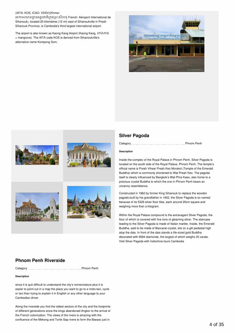
(IATA: KOS, ICAO: VDSV)(Khmer:ស ន នអនរ តិ កង ពះសីហនុ French: Aéroport International de
Sihanouk), located 20 kilometres (12 mi) east of Sihanoukville in PreahSihanouk Province, is Cambodia's third largest international airport.
The airport is also known as Kaong Kang Airport (Kaong Kang, េ ង ង= mangrove). The IATA code KOS is derived from Sihanoukville'salternative name Kompong Som.
Category Phnom Penh
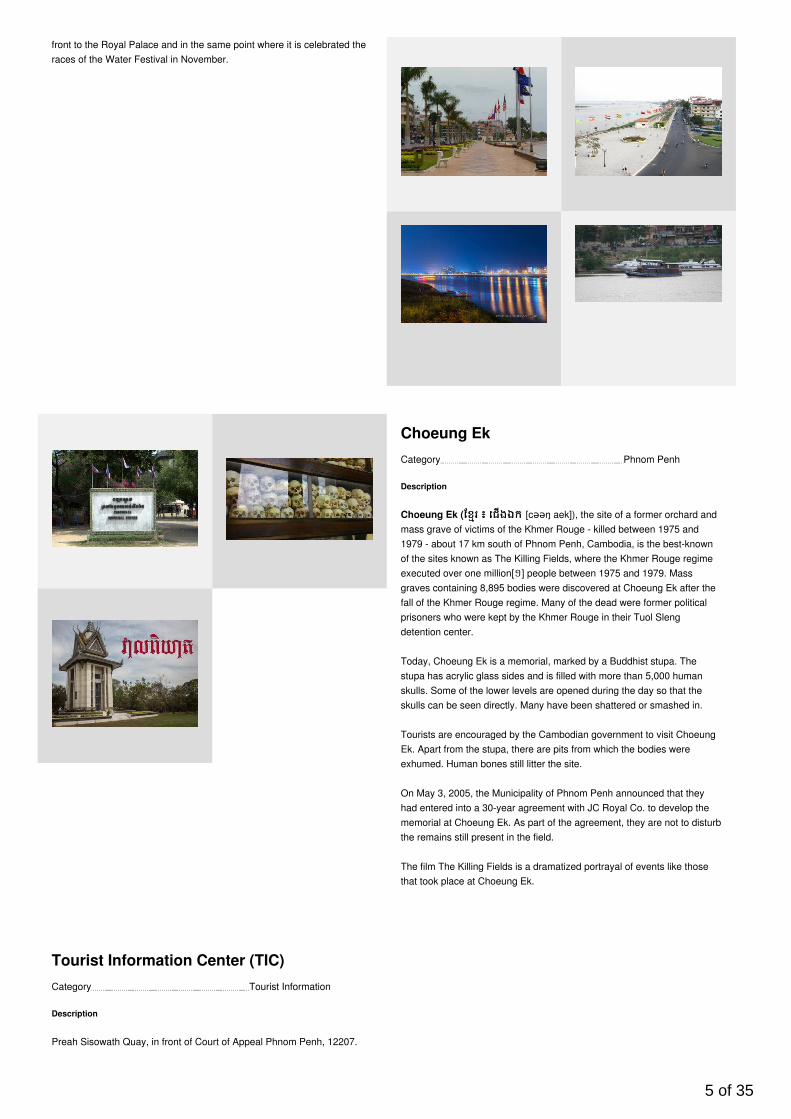
Silver Pagoda
Description
Inside the complex of the Royal Palace in Phnom Penh, Silver Pagoda islocated on the south side of the Royal Palace, Phnom Penh. The temple’sofficial name is Preah Vihear Preah Keo Morakot (Temple of the EmeraldBuddha) which is commonly shortened to Wat Preah Keo. The pagodaitself is clearly influenced by Bangkok’s Wat Phra Kaeo, also home to aprecious crystal Buddha to which the one in Phnom Penh bears anuncanny resemblance.
Constructed in 1962 by former King Sihanouk to replace the woodenpagoda built by his grandfather in 1902, the Silver Pagoda is so namedbecause of its 5329 silver floor tiles, each around 20cm square andweighing more than a kilogram.
Within the Royal Palace compound is the extravagant Silver Pagoda, thefloor of which is covered with five tons of gleaming silver. The staircaseleading to the Silver Pagoda is made of Italian marble. Inside, the EmeraldBuddha, said to be made of Baccarat crystal, sits on a gilt pedestal highatop the dais. In front of the dais stands a life-sized gold Buddhadecorated with 9584 diamonds, the largest of which weighs 25 carats.Visit Silver Pagoda with Indochina tours Cambodia
Category Phnom Penh
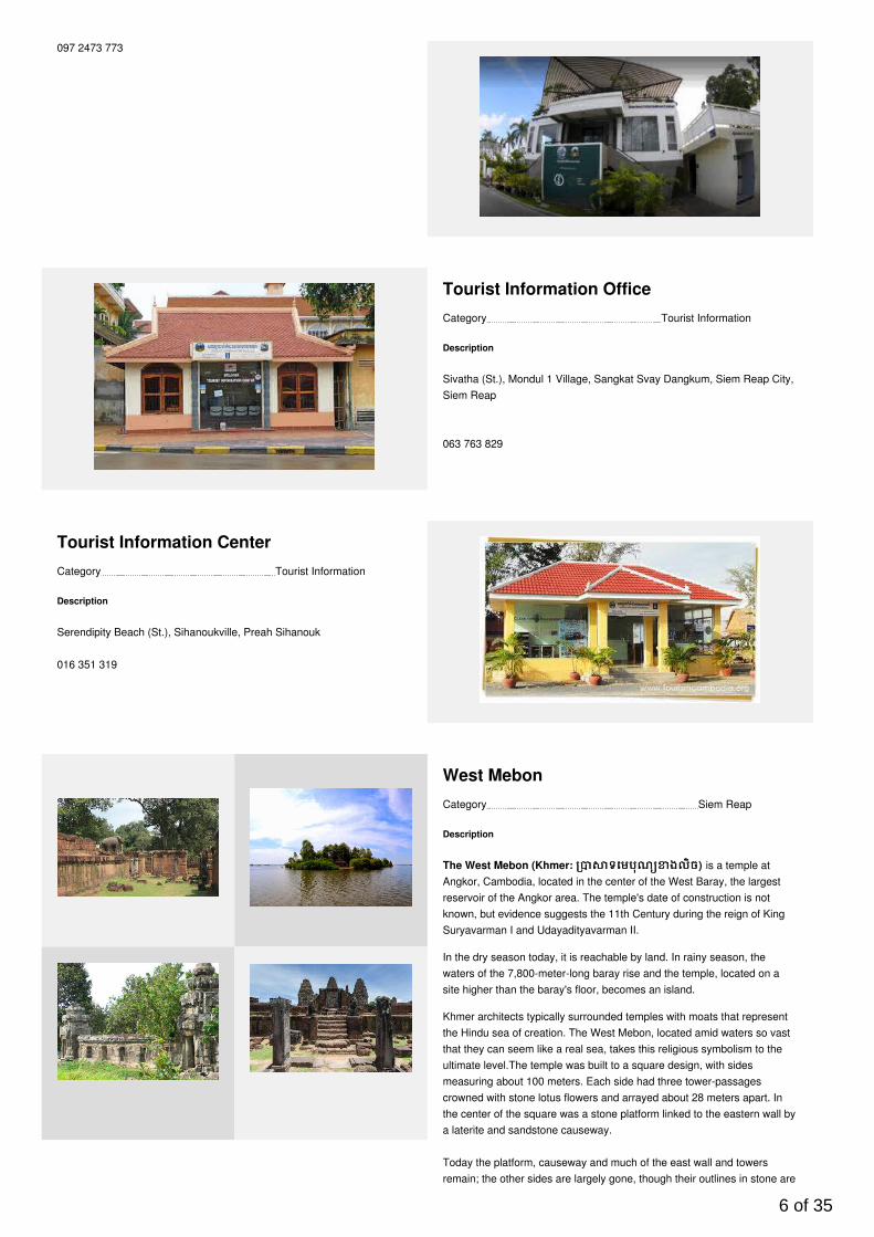
Phnom Penh Riverside
Description
since it is quit difficult to understand the city’s nomenclature plus it iseasier to point out in a map the place you want to go to a moto-taxi, cycleor taxi than trying to explain it in English or any other language to yourCambodian driver.
Along the riverside you find the oldest sectors of the city and the footprintsof different generations since the kings abandoned Angkor to the arrival ofthe French colonization. The views of the rivers is amazing with theconfluence of the Mekong and Tonle Sap rivers to form the Bassac just in
4 of 35
front to the Royal Palace and in the same point where it is celebrated theraces of the Water Festival in November.
Category Phnom Penh
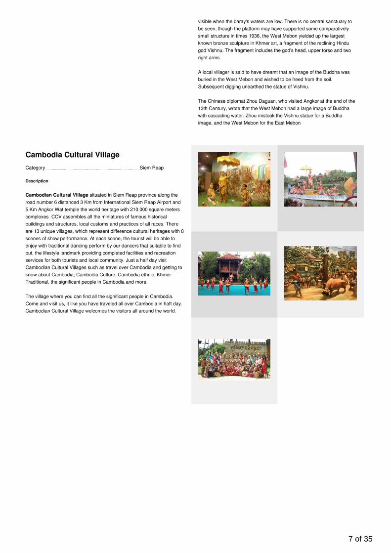
Choeung Ek
Description
Choeung Ek (ែខរែខរ ៖៖ េជងឯកេជងឯក [cəəŋ aek]), the site of a former orchard andmass grave of victims of the Khmer Rouge - killed between 1975 and1979 - about 17 km south of Phnom Penh, Cambodia, is the best-knownof the sites known as The Killing Fields, where the Khmer Rouge regimeexecuted over one million[១] people between 1975 and 1979. Massgraves containing 8,895 bodies were discovered at Choeung Ek after thefall of the Khmer Rouge regime. Many of the dead were former politicalprisoners who were kept by the Khmer Rouge in their Tuol Slengdetention center.
Today, Choeung Ek is a memorial, marked by a Buddhist stupa. Thestupa has acrylic glass sides and is filled with more than 5,000 humanskulls. Some of the lower levels are opened during the day so that theskulls can be seen directly. Many have been shattered or smashed in.
Tourists are encouraged by the Cambodian government to visit ChoeungEk. Apart from the stupa, there are pits from which the bodies wereexhumed. Human bones still litter the site.
On May 3, 2005, the Municipality of Phnom Penh announced that theyhad entered into a 30-year agreement with JC Royal Co. to develop thememorial at Choeung Ek. As part of the agreement, they are not to disturbthe remains still present in the field.
The film The Killing Fields is a dramatized portrayal of events like thosethat took place at Choeung Ek.
Category Tourist Information
Tourist Information Center (TIC)
Description
Preah Sisowath Quay, in front of Court of Appeal Phnom Penh, 12207.
5 of 35
097 2473 773
Category Tourist Information
Tourist Information Office
Description
Sivatha (St.), Mondul 1 Village, Sangkat Svay Dangkum, Siem Reap City,Siem Reap
063 763 829
Category Tourist Information
Tourist Information Center
Description
Serendipity Beach (St.), Sihanoukville, Preah Sihanouk
016 351 319
Category Siem Reap
West Mebon
Description
The West Mebon (Khmer: ទេមបុណ ងលិចទេមបុណ ងលិច) is a temple atAngkor, Cambodia, located in the center of the West Baray, the largestreservoir of the Angkor area. The temple's date of construction is notknown, but evidence suggests the 11th Century during the reign of KingSuryavarman I and Udayadityavarman II.
In the dry season today, it is reachable by land. In rainy season, thewaters of the 7,800-meter-long baray rise and the temple, located on asite higher than the baray's floor, becomes an island.
Khmer architects typically surrounded temples with moats that representthe Hindu sea of creation. The West Mebon, located amid waters so vastthat they can seem like a real sea, takes this religious symbolism to theultimate level.The temple was built to a square design, with sidesmeasuring about 100 meters. Each side had three tower-passagescrowned with stone lotus flowers and arrayed about 28 meters apart. Inthe center of the square was a stone platform linked to the eastern wall bya laterite and sandstone causeway.
Today the platform, causeway and much of the east wall and towersremain; the other sides are largely gone, though their outlines in stone are
6 of 35
visible when the baray's waters are low. There is no central sanctuary tobe seen, though the platform may have supported some comparativelysmall structure in times 1936, the West Mebon yielded up the largestknown bronze sculpture in Khmer art, a fragment of the reclining Hindugod Vishnu. The fragment includes the god's head, upper torso and tworight arms.
A local villager is said to have dreamt that an image of the Buddha wasburied in the West Mebon and wished to be freed from the soil.Subsequent digging unearthed the statue of Vishnu.
The Chinese diplomat Zhou Daguan, who visited Angkor at the end of the13th Century, wrote that the West Mebon had a large image of Buddhawith cascading water. Zhou mistook the Vishnu statue for a Buddhaimage, and the West Mebon for the East Mebon
Category Siem Reap
Cambodia Cultural Village
Description
Cambodian Cultural Village situated in Siem Reap province along theroad number 6 distanced 3 Km from International Siem Reap Airport and5 Km Angkor Wat temple the world heritage with 210.000 square meterscomplexes. CCV assembles all the miniatures of famous historicalbuildings and structures, local customs and practices of all races. Thereare 13 unique villages, which represent difference cultural heritages with 8scenes of show performance. At each scene, the tourist will be able toenjoy with traditional dancing perform by our dancers that suitable to findout, the lifestyle landmark providing completed facilities and recreationservices for both tourists and local community. Just a half day visitCambodian Cultural Villages such as travel over Cambodia and getting toknow about Cambodia, Cambodia Culture, Cambodia ethnic, KhmerTraditional, the significant people in Cambodia and more.
The village where you can find all the significant people in Cambodia.Come and visit us, it like you have traveled all over Cambodia in haft day.Cambodian Cultural Village welcomes the visitors all around the world.
7 of 35
Category Siem Reap
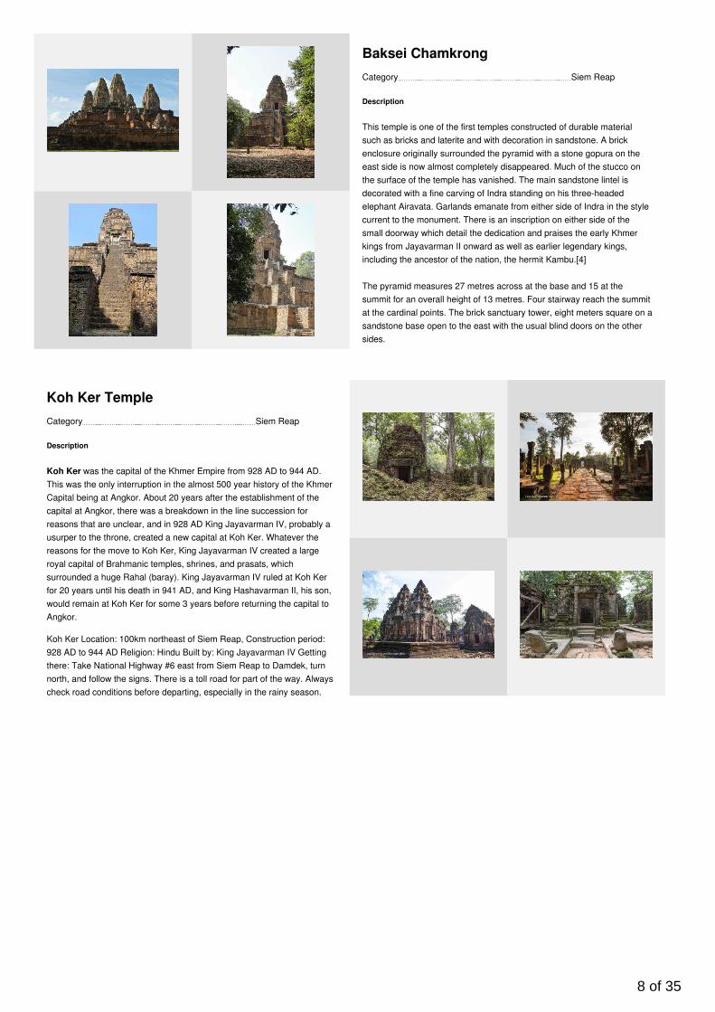
Baksei Chamkrong
Description
This temple is one of the first temples constructed of durable materialsuch as bricks and laterite and with decoration in sandstone. A brickenclosure originally surrounded the pyramid with a stone gopura on theeast side is now almost completely disappeared. Much of the stucco onthe surface of the temple has vanished. The main sandstone lintel isdecorated with a fine carving of Indra standing on his three-headedelephant Airavata. Garlands emanate from either side of Indra in the stylecurrent to the monument. There is an inscription on either side of thesmall doorway which detail the dedication and praises the early Khmerkings from Jayavarman II onward as well as earlier legendary kings,including the ancestor of the nation, the hermit Kambu.[4]
The pyramid measures 27 metres across at the base and 15 at thesummit for an overall height of 13 metres. Four stairway reach the summitat the cardinal points. The brick sanctuary tower, eight meters square on asandstone base open to the east with the usual blind doors on the othersides.
Category Siem Reap
Koh Ker Temple
Description
Koh Ker was the capital of the Khmer Empire from 928 AD to 944 AD.This was the only interruption in the almost 500 year history of the KhmerCapital being at Angkor. About 20 years after the establishment of thecapital at Angkor, there was a breakdown in the line succession forreasons that are unclear, and in 928 AD King Jayavarman IV, probably ausurper to the throne, created a new capital at Koh Ker. Whatever thereasons for the move to Koh Ker, King Jayavarman IV created a largeroyal capital of Brahmanic temples, shrines, and prasats, whichsurrounded a huge Rahal (baray). King Jayavarman IV ruled at Koh Kerfor 20 years until his death in 941 AD, and King Hashavarman II, his son,would remain at Koh Ker for some 3 years before returning the capital toAngkor.
Koh Ker Location: 100km northeast of Siem Reap, Construction period:928 AD to 944 AD Religion: Hindu Built by: King Jayavarman IV Gettingthere: Take National Highway #6 east from Siem Reap to Damdek, turnnorth, and follow the signs. There is a toll road for part of the way. Alwayscheck road conditions before departing, especially in the rainy season.
8 of 35

Category Phnom Penh
Phnom Penh Night Market
Description
Night Market in Phnom Penh is located just by the riverfront and offers awide and varied range of Cambodian handicrafts silks, art, clothes andsouvenirs. The market was originally aimed towards visitors and touristsbut interestingly thought is that it is probably more popular amongCambodians than foreigners.
The market has a more relaxing, cooler and festive atmosphere than atypical local market in Phnom Penh. In the middle of the market is a bigstage where they most of the time have some kind of performance orconcert. There is also a picnic area behind the stage where you can sitdown and enjoy the food from the food stands and listen to music.
The Night Market is opened every Friday, Saturday and Sunday eveningfrom 5 pm to midnight.
Location: Night Market (Phsar Reatrey) is located on Street 1 (PreahSisowath Quay) in Wat Phnom Commune , Daun Penh District
Category Seaside Area
Ream National Park
Description
Ream National Park is a national park of Cambodia located 18 km fromSihanoukville city in the Prey Nob district of the Sihanoukville Province insouth-eastern Cambodia. It was established in 1993, as the Cambodiangovernment began to take action for the protection of the country'sthreatened natural resources. The national park's biological value isdefined by its combination of rivers, forests, mangroves, estuaries,beaches, coral reefs, wildlife, and marine life.
Contact:
092 628 878
9 of 35
10 of 35
Category Siem Reap
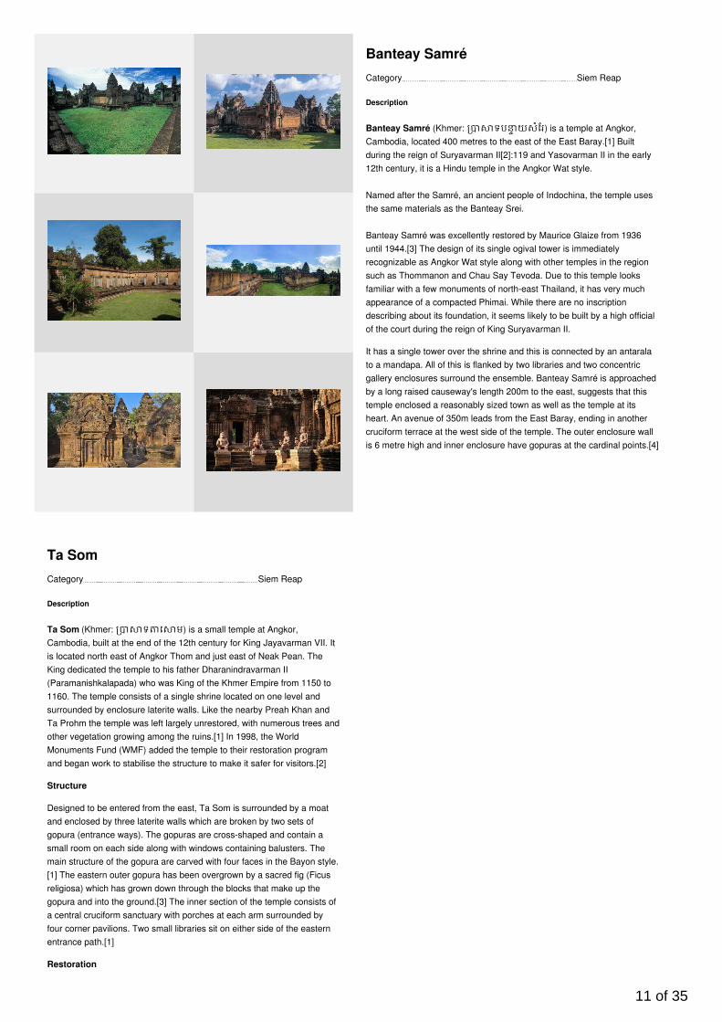
Banteay Samré
Description
Banteay Samré (Khmer: ទប យសំែរ) is a temple at Angkor,Cambodia, located 400 metres to the east of the East Baray.[1] Builtduring the reign of Suryavarman II[2]:119 and Yasovarman II in the early12th century, it is a Hindu temple in the Angkor Wat style.
Named after the Samré, an ancient people of Indochina, the temple usesthe same materials as the Banteay Srei.
Banteay Samré was excellently restored by Maurice Glaize from 1936until 1944.[3] The design of its single ogival tower is immediatelyrecognizable as Angkor Wat style along with other temples in the regionsuch as Thommanon and Chau Say Tevoda. Due to this temple looksfamiliar with a few monuments of north-east Thailand, it has very muchappearance of a compacted Phimai. While there are no inscriptiondescribing about its foundation, it seems likely to be built by a high officialof the court during the reign of King Suryavarman II.
It has a single tower over the shrine and this is connected by an antaralato a mandapa. All of this is flanked by two libraries and two concentricgallery enclosures surround the ensemble. Banteay Samré is approachedby a long raised causeway's length 200m to the east, suggests that thistemple enclosed a reasonably sized town as well as the temple at itsheart. An avenue of 350m leads from the East Baray, ending in anothercruciform terrace at the west side of the temple. The outer enclosure wallis 6 metre high and inner enclosure have gopuras at the cardinal points.[4]
Category Siem Reap
Ta Som
Description
Ta Som (Khmer: ទ េ ម) is a small temple at Angkor,Cambodia, built at the end of the 12th century for King Jayavarman VII. Itis located north east of Angkor Thom and just east of Neak Pean. TheKing dedicated the temple to his father Dharanindravarman II(Paramanishkalapada) who was King of the Khmer Empire from 1150 to1160. The temple consists of a single shrine located on one level andsurrounded by enclosure laterite walls. Like the nearby Preah Khan andTa Prohm the temple was left largely unrestored, with numerous trees andother vegetation growing among the ruins.[1] In 1998, the WorldMonuments Fund (WMF) added the temple to their restoration programand began work to stabilise the structure to make it safer for visitors.[2]
Structure
Designed to be entered from the east, Ta Som is surrounded by a moatand enclosed by three laterite walls which are broken by two sets ofgopura (entrance ways). The gopuras are cross-shaped and contain asmall room on each side along with windows containing balusters. Themain structure of the gopura are carved with four faces in the Bayon style.[1] The eastern outer gopura has been overgrown by a sacred fig (Ficusreligiosa) which has grown down through the blocks that make up thegopura and into the ground.[3] The inner section of the temple consists ofa central cruciform sanctuary with porches at each arm surrounded byfour corner pavilions. Two small libraries sit on either side of the easternentrance path.[1]
Restoration
11 of 35
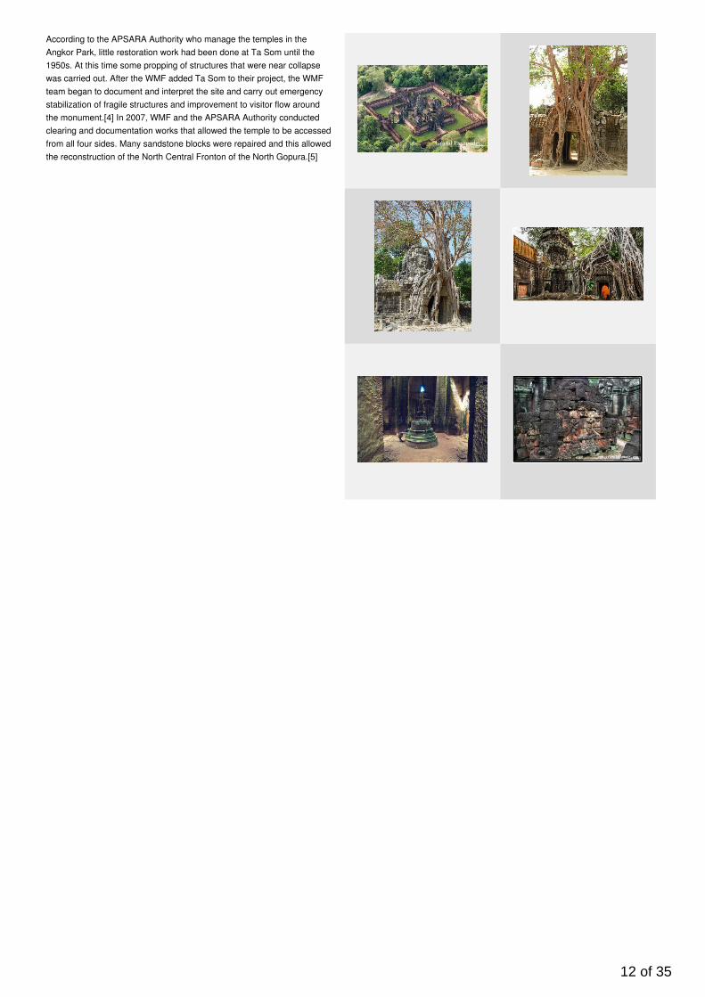
According to the APSARA Authority who manage the temples in theAngkor Park, little restoration work had been done at Ta Som until the1950s. At this time some propping of structures that were near collapsewas carried out. After the WMF added Ta Som to their project, the WMFteam began to document and interpret the site and carry out emergencystabilization of fragile structures and improvement to visitor flow aroundthe monument.[4] In 2007, WMF and the APSARA Authority conductedclearing and documentation works that allowed the temple to be accessedfrom all four sides. Many sandstone blocks were repaired and this allowedthe reconstruction of the North Central Fronton of the North Gopura.[5]
12 of 35
Category Siem Reap
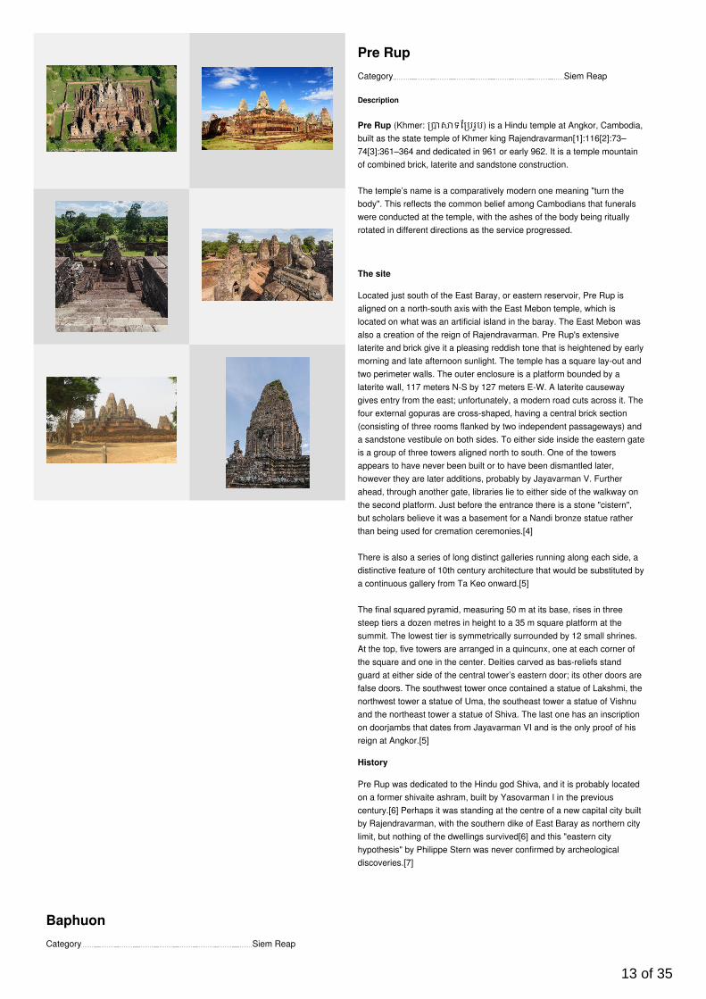
Pre Rup
Description
Pre Rup (Khmer: ទែ បរបូ) is a Hindu temple at Angkor, Cambodia,built as the state temple of Khmer king Rajendravarman[1]:116[2]:73–74[3]:361–364 and dedicated in 961 or early 962. It is a temple mountainof combined brick, laterite and sandstone construction.
The temple’s name is a comparatively modern one meaning "turn thebody". This reflects the common belief among Cambodians that funeralswere conducted at the temple, with the ashes of the body being rituallyrotated in different directions as the service progressed.
The site
Located just south of the East Baray, or eastern reservoir, Pre Rup isaligned on a north-south axis with the East Mebon temple, which islocated on what was an artificial island in the baray. The East Mebon wasalso a creation of the reign of Rajendravarman. Pre Rup's extensivelaterite and brick give it a pleasing reddish tone that is heightened by earlymorning and late afternoon sunlight. The temple has a square lay-out andtwo perimeter walls. The outer enclosure is a platform bounded by alaterite wall, 117 meters N-S by 127 meters E-W. A laterite causewaygives entry from the east; unfortunately, a modern road cuts across it. Thefour external gopuras are cross-shaped, having a central brick section(consisting of three rooms flanked by two independent passageways) anda sandstone vestibule on both sides. To either side inside the eastern gateis a group of three towers aligned north to south. One of the towersappears to have never been built or to have been dismantled later,however they are later additions, probably by Jayavarman V. Furtherahead, through another gate, libraries lie to either side of the walkway onthe second platform. Just before the entrance there is a stone "cistern",but scholars believe it was a basement for a Nandi bronze statue ratherthan being used for cremation ceremonies.[4]
There is also a series of long distinct galleries running along each side, adistinctive feature of 10th century architecture that would be substituted bya continuous gallery from Ta Keo onward.[5]
The final squared pyramid, measuring 50 m at its base, rises in threesteep tiers a dozen metres in height to a 35 m square platform at thesummit. The lowest tier is symmetrically surrounded by 12 small shrines.At the top, five towers are arranged in a quincunx, one at each corner ofthe square and one in the center. Deities carved as bas-reliefs standguard at either side of the central tower’s eastern door; its other doors arefalse doors. The southwest tower once contained a statue of Lakshmi, thenorthwest tower a statue of Uma, the southeast tower a statue of Vishnuand the northeast tower a statue of Shiva. The last one has an inscriptionon doorjambs that dates from Jayavarman VI and is the only proof of hisreign at Angkor.[5]
History
Pre Rup was dedicated to the Hindu god Shiva, and it is probably locatedon a former shivaite ashram, built by Yasovarman I in the previouscentury.[6] Perhaps it was standing at the centre of a new capital city builtby Rajendravarman, with the southern dike of East Baray as northern citylimit, but nothing of the dwellings survived[6] and this "eastern cityhypothesis" by Philippe Stern was never confirmed by archeologicaldiscoveries.[7]
Category Siem Reap
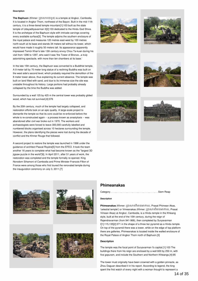
Baphuon
13 of 35
Description
The Baphuon (Khmer: ទ ពួន) is a temple at Angkor, Cambodia.It is located in Angkor Thom, northwest of the Bayon. Built in the mid-11thcentury, it is a three-tiered temple mountain[1]:103 built as the statetemple of Udayadityavarman II[2]:103 dedicated to the Hindu God Shiva.It is the archetype of the Baphuon style with intricate carvings coveringevery available surface[3]. The temple adjoins the southern enclosure ofthe royal palace and measures 120 metres east-west by 100 metresnorth-south at its base and stands 34 meters tall without its tower, whichwould have made it roughly 50 meters tall. Its appearance apparentlyimpressed Temür Khan's late 13th century envoy Chou Ta-kuan during hisvisit from 1296 to 1297, who said it was 'the Tower of Bronze...a trulyastonishing spectacle, with more than ten chambers at its base.'
In the late 15th century, the Baphuon was converted to a Buddhist temple.A 9 meter tall by 70 meter long statue of a reclining Buddha was built onthe west side's second level, which probably required the demolition of the8 meter tower above, thus explaining its current absence. The temple wasbuilt on land filled with sand, and due to its immense size the site wasunstable throughout its history. Large portions had probably alreadycollapsed by the time the Buddha was added.
Surrounded by a wall 125 by 425 m the central tower was probably gildedwood, which has not survived.[4]:376
By the 20th century, much of the temple had largely collapsed, andrestoration efforts took on an epic quality. A large-scale project todismantle the temple so that its core could be re-enforced before thewhole is re-constructed again -- a process known as anastylosis -- wasabandoned after civil war broke out in 1970. The workers andarchaeologists were forced to leave 300,000 carefully labelled andnumbered blocks organised across 10 hectares surrounding the temple.However, the plans identifying the pieces were lost during the decade ofconflict and the Khmer Rouge that followed.
A second project to restore the temple was launched in 1996 under theguidance of architect Pascal Royère[5] from the EFEO. It took the teamanother 16 years to complete what had become known as the "largest 3Djigsaw puzzle in the world"[6]. In April 2011, after 51 years of work, therestoration was completed and the temple formally re-opened. KingNorodom Sihamoni of Cambodia and Prime Minister Francois Fillon ofFrance were among those who first toured the renovated temple duringthe inauguration ceremony on July 3, 2011.[7]
Category Siem Reap
Phimeanakas
Description
Phimeanakas (Khmer: ទភិ ន ស, Prasat Phimean Akas,'celestial temple') or Vimeanakas (Khmer: ទវ ិ ន ស, PrasatVimean Akas) at Angkor, Cambodia, is a Hindu temple in the Khleangstyle, built at the end of the 10th century, during the reign ofRajendravarman (from 941-968), then completed by SuryavarmanI[1]:115,135[2]:371 in the shape of a three tier pyramid as a Hindu temple.On top of the pyramid there was a tower, while on the edge of top platformthere are galleries. Phimeanakas is located inside the walled enclosure ofthe Royal Palace of Angkor Thom north of Baphuon.[3]
Description
The temple was the focal point of Suryavarman I's capital.[1]:103 Thebuildings there from his reign are enclosed by a wall 600 by 250 m, withfive gopuram, and include the Southern and Northern Khleangs.[4]:95
The tower must originally have been crowned with a golden pinnacle, asZhou Daguan described it in his report. According to legend, the kingspent the first watch of every night with a woman thought to represent a
14 of 35
Nāga in the tower, during that time, not even the queen was permitted tointrude. Only in the second watch the king returned to his palace with thequeen. If the naga who was the supreme land owner of Khmer land didnot show up for a night, the king's day would be numbered, if the king didnot show up, calamity would strike his land.[5]
One of the stele states Jayavarman VII, while on a military expedition inChampa, learned that his father Dharanindravarman II had died, and"returned in great haste to aid King Yasovarman II. Jayavarman's secondwife, Indradevi, "...composed in impeccable Sanskrit theinscription...panegyric of her sister" Jayarajadevi, which includedbiographical detail of Jayavarman VII.[1]:169,172
Category Siem Reap
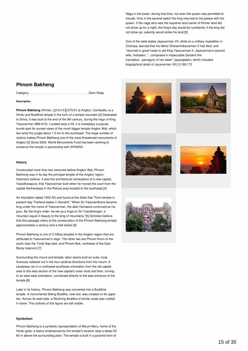
Phnom Bakheng
Description
Phnom Bakheng (Khmer: ទភំ ែខង) at Angkor, Cambodia, is aHindu and Buddhist temple in the form of a temple mountain.[2] Dedicatedto Shiva, it was built at the end of the 9th century, during the reign of KingYasovarman (889-910). Located atop a hill, it is nowadays a populartourist spot for sunset views of the much bigger temple Angkor Wat, whichlies amid the jungle about 1.5 km to the southeast. The large number ofvisitors makes Phnom Bakheng one of the most threatened monuments ofAngkor.[3] Since 2004, World Monuments Fund has been working toconserve the temple in partnership with APSARA.
History
Constructed more than two centuries before Angkor Wat, PhnomBakheng was in its day the principal temple of the Angkor region,historians believe. It was the architectural centerpiece of a new capital,Yasodharapura, that Yasovarman built when he moved the court from thecapital Hariharalaya in the Roluos area located to the southeast.[4]
An inscription dated 1052 AD and found at the Sdok Kak Thom temple inpresent-day Thailand states in Sanskrit: "When Sri Yasovardhana becameking under the name of Yasovarman, the able Vamasiva continued as hisguru. By the king's order, he set up a linga on Sri Yasodharagiri, amountain equal in beauty to the king of mountains."[5] Scholars believethat this passage refers to the consecration of the Phnom Bakheng templeapproximately a century and a half earlier.[6]
Phnom Bakheng is one of 3 hilltop temples in the Angkor region that areattributed to Yasovarman's reign. The other two are Phnom Krom to thesouth near the Tonle Sap lake, and Phnom Bok, northeast of the EastBaray reservoir.[7]
Surrounding the mount and temple, labor teams built an outer moat.Avenues radiated out in the four cardinal directions from the mount. Acauseway ran in a northwest-southeast orientation from the old capitalarea to the east section of the new capital's outer moat and then, turningto an east-west orientation, connected directly to the east entrance of thetemple.[8]
Later in its history, Phnom Bakheng was converted into a Buddhisttemple. A monumental Sitting Buddha, now lost, was created on its uppertier. Across its west side, a Reclining Buddha of similar scale was craftedin stone. The outlines of this figure are still visible.
Symbolism
Phnom Bakheng is a symbolic representation of Mount Meru, home of theHindu gods, a status emphasized by the temple’s location atop a steep hill65 m above the surrounding plain. The temple is built in a pyramid form of
15 of 35

seven levels, representing the seven heavens.[9] At the top level, fivesandstone sanctuaries, in various states of repair, stand in a quincunxpattern—one in the center and one at each corner of the level’s square.Originally, 108 small towers were arrayed around the temple at groundlevel and on various of its tiers; most of them have collapsed.[10]
Jean Filliozat of the Ecole Francaise, a leading western authority onIndian cosmology and astronomy, interpreted the symbolism of thetemple. The temple sits on a rectangular base and rises in five levels andis crowned by five main towers. One hundred four smaller towers aredistributed over the lower four levels, placed so symmetrically that only 33can be seen from the center of any side. Thirty-three is the number ofgods who dwelt on Mount Meru. Phnom Bakheng's total number of towersis also significant. The center one represents the axis of the world and the108 smaller ones represent the four lunar phases, each with 27 days. Theseven levels of the monument represent the seven heavens and eachterrace contains 12 towers which represent the 12-year cycle of Jupiter.According to University of Chicago scholar Paul Wheatley, it is "anastronomical calendar in stone." [11]
Following Angkor's rediscovery by the outside world in the mid-19thcentury, decades passed before archeologists grasped Phnom Bakheng'shistorical significance. For many years, scholars' consensus view was thatthe Bayon, the temple located at the center of Angkor Thom city, was theedifice to which the Sdok Kak Thom inscription referred. Later workidentified the Bayon as a Buddhist site, built almost three centuries laterthan originally thought, in the late 12th century, and Phnom Bakheng asKing Yasovarman's state temple.[6]
Category Siem Reap
Preah Khan
Description
Preah Khan (Khmer: ទ ពះខ័ន; "Royal Sword") is a temple atAngkor, Cambodia, built in the 12th century for King Jayavarman VII tohonor his father.[1]:383–384,389[2]:174–176 It is located northeast ofAngkor Thom and just west of the Jayatataka baray, with which it wasassociated. It was the centre of a substantial organisation, with almost100,000 officials and servants. The temple is flat in design, with a basicplan of successive rectangular galleries around a Buddhist sanctuarycomplicated by Hindu satellite temples and numerous later additions. Likethe nearby Ta Prohm, Preah Khan has been left largely unrestored, withnumerous trees and other vegetation growing among the ruins.
Preah Khan was built on the site of Jayavarman VII's victory over theinvading Chams in 1191. Unusually the modern name, meaning "holysword", is derived from the meaning of the original—Nagara Jayasri (holycity of victory).[1] The site may previously have been occupied by theroyal palaces of Yasovarman II and Tribhuvanadityavarman.[2] Thetemple's foundation stela has provided considerable information about thehistory and administration of the site: the main image, of the bodhisattvaAvalokiteśvara in the form of the king's father, was dedicated in 1191 (theking's mother had earlier been commemorated in the same way at TaProhm). 430 other deities also had shrines on the site, each of whichreceived an allotment of food, clothing, perfume and even mosquito nets;[3] the temple's wealth included gold, silver, gems, 112,300 pearls and acow with gilded horns.[4] The institution combined the roles of city, templeand Buddhist university: there were 97,840 attendants and servants,including 1000 dancers[5] and 1000 teachers.[6]
The temple is still largely unrestored: the initial clearing was from 1927 to1932, and partial anastylosis was carried out in 1939. Since then free-standing statues have been removed for safe-keeping, and there hasbeen further consolidation and restoration work.
16 of 35
Category Siem Reap
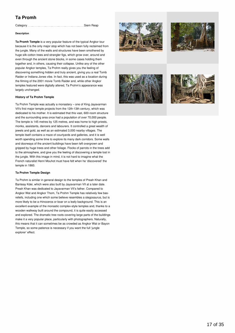
Ta Promh
Description
Ta Promh Temple is a very popular feature of the typical Angkor tourbecause it is the only major stop which has not been fully reclaimed fromthe jungle. Many of the walls and structures have been smothered byhuge silk-cotton trees and strangler figs, which grow over, around andeven through the ancient stone blocks, in some cases holding themtogether and, in others, causing their collapse. Unlike any of the otherpopular Angkor temples, Ta Prohm really gives you the feeling ofdiscovering something hidden and truly ancient, giving you a real TombRaider or Indiana Jones vibe. In fact, this was used as a location duringthe filming of the 2001 movie Tomb Raider and, while other Angkortemples featured were digitally altered, Ta Prohm’s appearance waslargely unchanged.
History of Ta Prohm Temple
Ta Prohm Temple was actually a monastery – one of King JayavarmanVII's first major temple projects from the 12th-13th century, which wasdedicated to his mother. It is estimated that this vast, 600-room structureand the surrounding area once had a population of over 70,000 people.The temple is 145 metres by 125 metres, and was home to high priests,monks, assistants, dancers and labourers. It controlled a great wealth ofjewels and gold, as well as an estimated 3,000 nearby villages. Thetemple itself contains a maze of courtyards and galleries, and it is wellworth spending some time to explore its many dark corridors. Some wallsand doorways of the ancient buildings have been left overgrown andgripped by huge trees and other foliage. Flocks of parrots in the trees addto the atmosphere, and give you the feeling of discovering a temple lost inthe jungle. With this image in mind, it is not hard to imagine what theFrench naturalist Henri Mouhot must have felt when he ‘discovered’ thetemple in 1860.
Ta Prohm Temple Design
Ta Prohm is similar in general design to the temples of Preah Khan andBanteay Kdei, which were also built by Jayavarman VII at a later date.Preah Khan was dedicated to Jayavarman VII’s father. Compared toAngkor Wat and Angkor Thom, Ta Prohm Temple has relatively few bas-reliefs, including one which some believe resembles a stegosaurus, but ismore likely to be a rhinoceros or boar on a leafy background. This is anexcellent example of the monastic complex-style temples and, thanks to awooden walkway built around the compound, it is quite easily accessedand explored. The dramatic tree roots covering large parts of the buildingsmake it a very popular place, particularly with photographers. Naturally,this means that it can sometimes be as crowded as Angkor Wat or BayonTemple, so some patience is necessary if you want the full ‘jungleexplorer’ effect.
17 of 35
Category Seaside Area
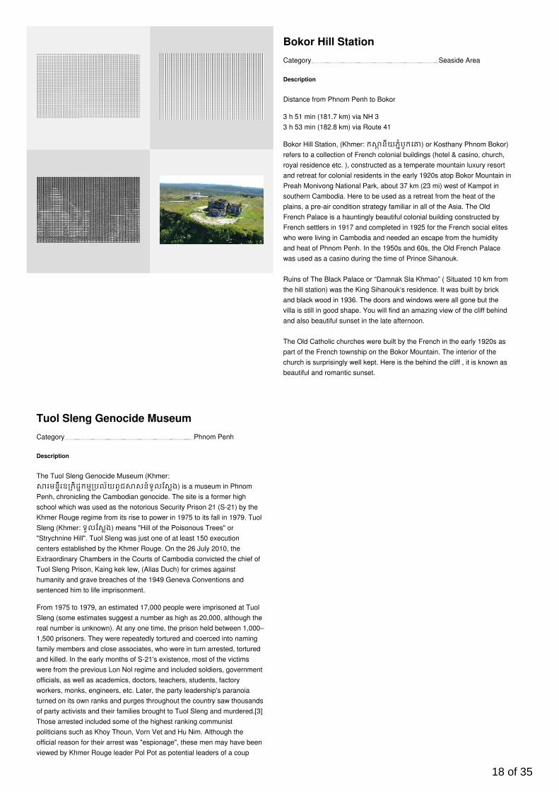
Bokor Hill Station
Description
Distance from Phnom Penh to B okor
3 h 51 min (181.7 km) via NH 33 h 53 min (182.8 km) via Route 41
Bokor Hill Station, (Khmer: ក នីយភំបូកេ ) or Kosthany Phnom Bokor)refers to a collection of French colonial buildings (hotel & casino, church,royal residence etc. ), constructed as a temperate mountain luxury resortand retreat for colonial residents in the early 1920s atop Bokor Mountain inPreah Monivong National Park, about 37 km (23 mi) west of Kampot insouthern Cambodia. Here to be used as a retreat from the heat of theplains, a pre-air condition strategy familiar in all of the Asia. The OldFrench Palace is a hauntingly beautiful colonial building constructed byFrench settlers in 1917 and completed in 1925 for the French social eliteswho were living in Cambodia and needed an escape from the humidityand heat of Phnom Penh. In the 1950s and 60s, the Old French Palacewas used as a casino during the time of Prince Sihanouk. Ruins of The Black Palace or “Damnak Sla Khmao” ( Situated 10 km fromthe hill station) was the King Sihanouk‘s residence. It was built by brickand black wood in 1936. The doors and windows were all gone but thevilla is still in good shape. You will find an amazing view of the cliff behindand also beautiful sunset in the late afternoon.
The Old Catholic churches were built by the French in the early 1920s aspart of the French township on the Bokor Mountain. The interior of thechurch is surprisingly well kept. Here is the behind the cliff , it is known asbeautiful and romantic sunset.
Category Phnom Penh
Tuol Sleng Genocide Museum
Description
The Tuol Sleng Genocide Museum (Khmer:រមនីរឧ កិដកម បល័យពូជ សន៍ទួលែសង) is a museum in Phnom
Penh, chronicling the Cambodian genocide. The site is a former highschool which was used as the notorious Security Prison 21 (S-21) by theKhmer Rouge regime from its rise to power in 1975 to its fall in 1979. TuolSleng (Khmer: ទួលែសង) means "Hill of the Poisonous Trees" or"Strychnine Hill". Tuol Sleng was just one of at least 150 executioncenters established by the Khmer Rouge. On the 26 July 2010, theExtraordinary Chambers in the Courts of Cambodia convicted the chief ofTuol Sleng Prison, Kaing kek Iew, (Alias Duch) for crimes againsthumanity and grave breaches of the 1949 Geneva Conventions andsentenced him to life imprisonment.
From 1975 to 1979, an estimated 17,000 people were imprisoned at TuolSleng (some estimates suggest a number as high as 20,000, although thereal number is unknown). At any one time, the prison held between 1,000–1,500 prisoners. They were repeatedly tortured and coerced into namingfamily members and close associates, who were in turn arrested, torturedand killed. In the early months of S-21's existence, most of the victimswere from the previous Lon Nol regime and included soldiers, governmentofficials, as well as academics, doctors, teachers, students, factoryworkers, monks, engineers, etc. Later, the party leadership's paranoiaturned on its own ranks and purges throughout the country saw thousandsof party activists and their families brought to Tuol Sleng and murdered.[3]Those arrested included some of the highest ranking communistpoliticians such as Khoy Thoun, Vorn Vet and Hu Nim. Although theofficial reason for their arrest was "espionage", these men may have beenviewed by Khmer Rouge leader Pol Pot as potential leaders of a coup
18 of 35
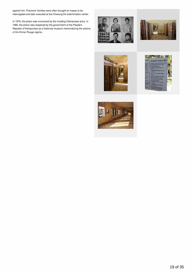
against him. Prisoners' families were often brought en masse to beinterrogated and later executed at the Choeung Ek extermination center.
In 1979, the prison was uncovered by the invading Vietnamese army. In1980, the prison was reopened by the government of the People'sRepublic of Kampuchea as a historical museum memorializing the actionsof the Khmer Rouge regime.
19 of 35
Category Siem Reap
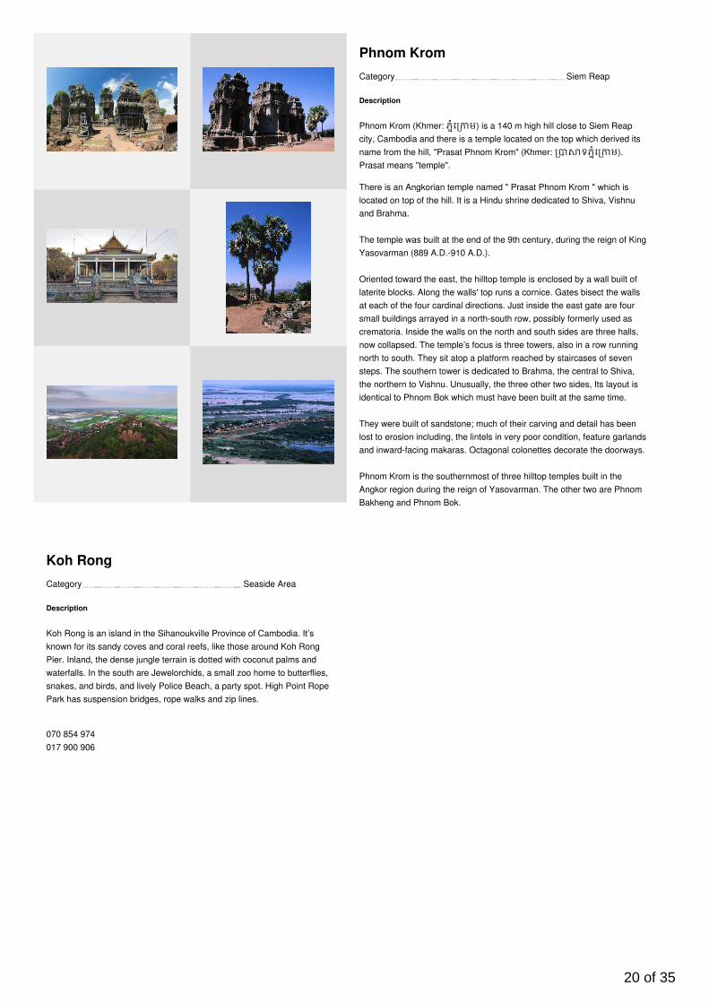
Phnom Krom
Description
Phnom Krom (Khmer: ភំេ ម) is a 140 m high hill close to Siem Reapcity, Cambodia and there is a temple located on the top which derived itsname from the hill, "Prasat Phnom Krom" (Khmer: ទភំេ ម).Prasat means "temple".
There is an Angkorian temple named " Prasat Phnom Krom " which islocated on top of the hill. It is a Hindu shrine dedicated to Shiva, Vishnuand Brahma.
The temple was built at the end of the 9th century, during the reign of KingYasovarman (889 A.D.-910 A.D.).
Oriented toward the east, the hilltop temple is enclosed by a wall built oflaterite blocks. Along the walls' top runs a cornice. Gates bisect the wallsat each of the four cardinal directions. Just inside the east gate are foursmall buildings arrayed in a north-south row, possibly formerly used ascrematoria. Inside the walls on the north and south sides are three halls,now collapsed. The temple’s focus is three towers, also in a row runningnorth to south. They sit atop a platform reached by staircases of sevensteps. The southern tower is dedicated to Brahma, the central to Shiva,the northern to Vishnu. Unusually, the three other two sides, Its layout isidentical to Phnom Bok which must have been built at the same time.
They were built of sandstone; much of their carving and detail has beenlost to erosion including, the lintels in very poor condition, feature garlandsand inward-facing makaras. Octagonal colonettes decorate the doorways.
Phnom Krom is the southernmost of three hilltop temples built in theAngkor region during the reign of Yasovarman. The other two are PhnomBakheng and Phnom Bok.
Category Seaside Area
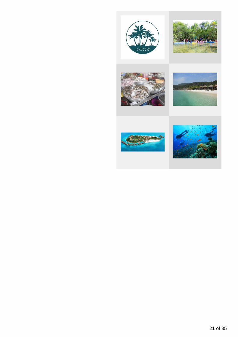
Koh Rong
Description
Koh Rong is an island in the Sihanoukville Province of Cambodia. It’sknown for its sandy coves and coral reefs, like those around Koh RongPier. Inland, the dense jungle terrain is dotted with coconut palms andwaterfalls. In the south are Jewelorchids, a small zoo home to butterflies,snakes, and birds, and lively Police Beach, a party spot. High Point RopePark has suspension bridges, rope walks and zip lines.
070 854 974017 900 906
20 of 35
21 of 35

Category Phnom Penh
The National Museum
Description
The National Museum of Cambodia (Khmer: រមនីរ តិ) in PhnomPenh is Cambodia's largest museum of cultural history and is thecountry's leading historical and archaeological museum.
George Groslier (1887–1945), historian, curator and author was themotivating force behind much of the revival of interest in traditionalCambodian arts and crafts, and it was he who designed this building thatis today ‘traditional Khmer’ architecture. It is perhaps better described asa building enlarged from Cambodian temple prototypes seen on ancientbas-reliefs and reinterpreted through colonial eyes to meet the museum-size requirements.
The foundation stone for the new museum was laid on 15 August 1917.Some two-and-a-half years later, the completed museum was inauguratedduring Khmer New Year on 13 April 1920 in the presence of H.M KingSisowath, François-Marius Baudoin, Résident-supérieur, and M. Groslier,director of Cambodian Arts, and Conservator of the museum.
The original design of the building was slightly altered in 1924 withextensions that added wings at either end of the eastern façade thatmade the building even more imposing.
Control of the National Museum and Arts Administration was ceded by theFrench to the Cambodians on 9 August 1951 and following Independencein 1953, the then Musée National de Phnom Penh was the subject ofbilateral accords. In 1966 Chea Thay Seng was the first CambodianDirector of the Museum and Dean of the newly created Department ofArchaeology at the Royal University of Fine Arts. This university that formits foundation as the Ecole des Arts Cambodgiens in 1920 was intimatelylinked with students, artisans and teachers who worked to preserveCambodian cultural traditions, can still be found to the rear of themuseum.
During the Khmer Rouge regime (from 1975 to 1979), all aspects ofCambodian life including the cultural realm were devastated. TheMuseum, along with the rest of Phnom Penh, was evacuated andabandoned. The Museum, closed between 1975 and 1979, and was foundin disrepair, its roof rotten and home to a vast colony of bats, the gardenovergrown, and the collection in disarray, many objects damaged orstolen. The Museum was quickly tidied up and reopened to the public on13 April 1979. However, many of the Museum's employees had lost theirlives during the Khmer Rouge regime.
Category Siem Reap
Neak Poan
Description
Neak Pean (or Neak Poan) (Khmer: ទ គព័ន) ("The entwinedserpents") at Angkor, Cambodia is an artificial island with a Buddhisttemple on a circular island in Jayatataka Baray, which was associatedwith Preah Khan temple, built during the reign of King Jayavarman VII.It isthe "Mebon" of the Preah Khan baray (the "Jayatataka" of the inscription).
Neak Pean was originally designed for medical purposes (the ancientsbelieved that going into these pools would balance the elements in thebather, thus curing disease); it is one of the many hospitals thatJayavarman VII built. It is based on the ancient Hindu belief of balance.Four connected pools represent Water, Earth, Fire and Wind. Each isconnected to the central water source, the main tank, by a stone conduit"presided over by one of Four Great Animals (maha ajaneya pasu)namely Elephant, Bull, Horse, and Lion, corresponding to the north, east,
22 of 35

south, and west quarters....The stone conduits in the little pavilions arefashioned to represent the heads of the Four Great Animals...the onlyexception being that on the east, which represents a human head insteadof a bull's." Originally, four sculptures stood on the floor of the lake. Theonly remaining statue is that of the horse Balaha, a form of thebodhisattva Avalokitesvara, saving sailors from the ogresses ofTamradvipa. The temple on the lake was originally dedicated toAvalokitesvara. Willetts believed that "this is Jayavarman as he wouldhave wished to have appeared to his people"
Zhou Daguan refers to Neak Pean in his visit to Angkor in the late 13thcentury.
Category Siem Reap
The Terrace of the Elephants
Description
The Terrace of the Elephants (Khmer: ពះ នជល់ដំរ)ី is part of thewalled city of Angkor Thom, a ruined temple complex in Cambodia. Theterrace was used by Angkor's king Jayavarman VII as a platform fromwhich to view his victorious returning army. It was attached to the palaceof Phimeanakas (Khmer: ទភិ ន ស), of which only a fewruins remain. Most of the original structure was made of organic materialand has long since disappeared. Most of what remains are the foundationplatforms of the complex. The terrace is named for the carvings ofelephants on its eastern face.
The 350m-long Terrace of Elephants was used as a giant reviewing standfor public ceremonies and served as a base for the king's grand audiencehall. It has five outworks extending towards the Central Square-three inthe centre and one at each end. The middle section of the retaining wall isdecorated with life size garuda and lions; towards either end are the twoparts of the famous parade of elephants complete with their Khmermahouts.
Category Siem Reap
Terrace of the Leper King
Description
The Terrace of the Leper King (or Leper King Terrace) (Khmer:
23 of 35
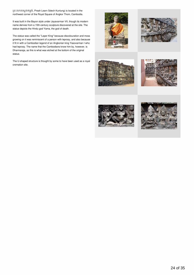
ពះ នេសចគមង់, Preah Learn Sdech Kunlung) is located in thenorthwest corner of the Royal Square of Angkor Thom, Cambodia.
It was built in the Bayon style under Jayavarman VII, though its modernname derives from a 15th-century sculpture discovered at the site. Thestatue depicts the Hindu god Yama, the god of death.
The statue was called the "Leper King" because discolouration and mossgrowing on it was reminiscent of a person with leprosy, and also becauseit fit in with a Cambodian legend of an Angkorian king Yasovarman I whohad leprosy. The name that the Cambodians know him by, however, isDharmaraja, as this is what was etched at the bottom of the originalstatue.
The U-shaped structure is thought by some to have been used as a royalcremation site.
24 of 35
Category Siem Reap
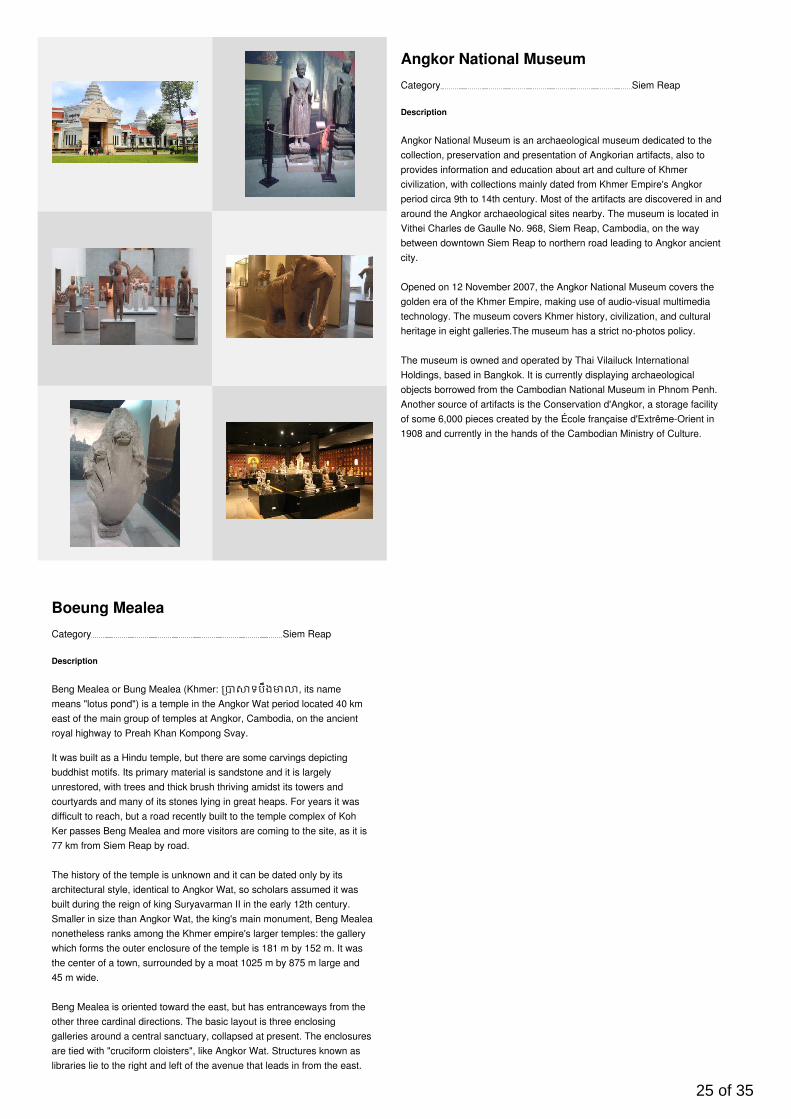
Angkor National Museum
Description
Angkor National Museum is an archaeological museum dedicated to thecollection, preservation and presentation of Angkorian artifacts, also toprovides information and education about art and culture of Khmercivilization, with collections mainly dated from Khmer Empire's Angkorperiod circa 9th to 14th century. Most of the artifacts are discovered in andaround the Angkor archaeological sites nearby. The museum is located inVithei Charles de Gaulle No. 968, Siem Reap, Cambodia, on the waybetween downtown Siem Reap to northern road leading to Angkor ancientcity.
Opened on 12 November 2007, the Angkor National Museum covers thegolden era of the Khmer Empire, making use of audio-visual multimediatechnology. The museum covers Khmer history, civilization, and culturalheritage in eight galleries.The museum has a strict no-photos policy.
The museum is owned and operated by Thai Vilailuck InternationalHoldings, based in Bangkok. It is currently displaying archaeologicalobjects borrowed from the Cambodian National Museum in Phnom Penh.Another source of artifacts is the Conservation d'Angkor, a storage facilityof some 6,000 pieces created by the École française d'Extrême-Orient in1908 and currently in the hands of the Cambodian Ministry of Culture.
Category Siem Reap
Boeung Mealea
Description
Beng Mealea or Bung Mealea (Khmer: ទបឹង , its namemeans "lotus pond") is a temple in the Angkor Wat period located 40 kmeast of the main group of temples at Angkor, Cambodia, on the ancientroyal highway to Preah Khan Kompong Svay.
It was built as a Hindu temple, but there are some carvings depictingbuddhist motifs. Its primary material is sandstone and it is largelyunrestored, with trees and thick brush thriving amidst its towers andcourtyards and many of its stones lying in great heaps. For years it wasdifficult to reach, but a road recently built to the temple complex of KohKer passes Beng Mealea and more visitors are coming to the site, as it is77 km from Siem Reap by road.
The history of the temple is unknown and it can be dated only by itsarchitectural style, identical to Angkor Wat, so scholars assumed it wasbuilt during the reign of king Suryavarman II in the early 12th century.Smaller in size than Angkor Wat, the king's main monument, Beng Mealeanonetheless ranks among the Khmer empire's larger temples: the gallerywhich forms the outer enclosure of the temple is 181 m by 152 m. It wasthe center of a town, surrounded by a moat 1025 m by 875 m large and45 m wide.
Beng Mealea is oriented toward the east, but has entranceways from theother three cardinal directions. The basic layout is three enclosinggalleries around a central sanctuary, collapsed at present. The enclosuresare tied with "cruciform cloisters", like Angkor Wat. Structures known aslibraries lie to the right and left of the avenue that leads in from the east.
25 of 35
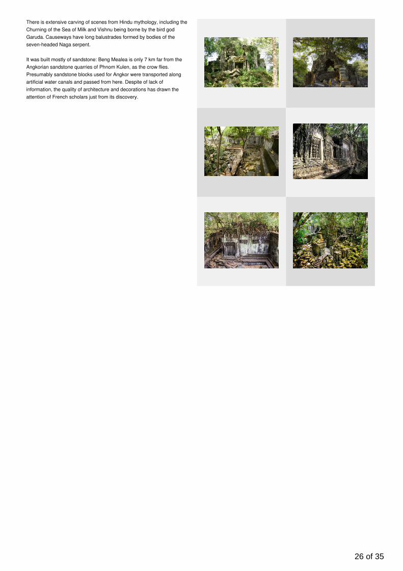
There is extensive carving of scenes from Hindu mythology, including theChurning of the Sea of Milk and Vishnu being borne by the bird godGaruda. Causeways have long balustrades formed by bodies of theseven-headed Naga serpent.
It was built mostly of sandstone: Beng Mealea is only 7 km far from theAngkorian sandstone quarries of Phnom Kulen, as the crow flies.Presumably sandstone blocks used for Angkor were transported alongartificial water canals and passed from here. Despite of lack ofinformation, the quality of architecture and decorations has drawn theattention of French scholars just from its discovery.
26 of 35
Category Siem Reap
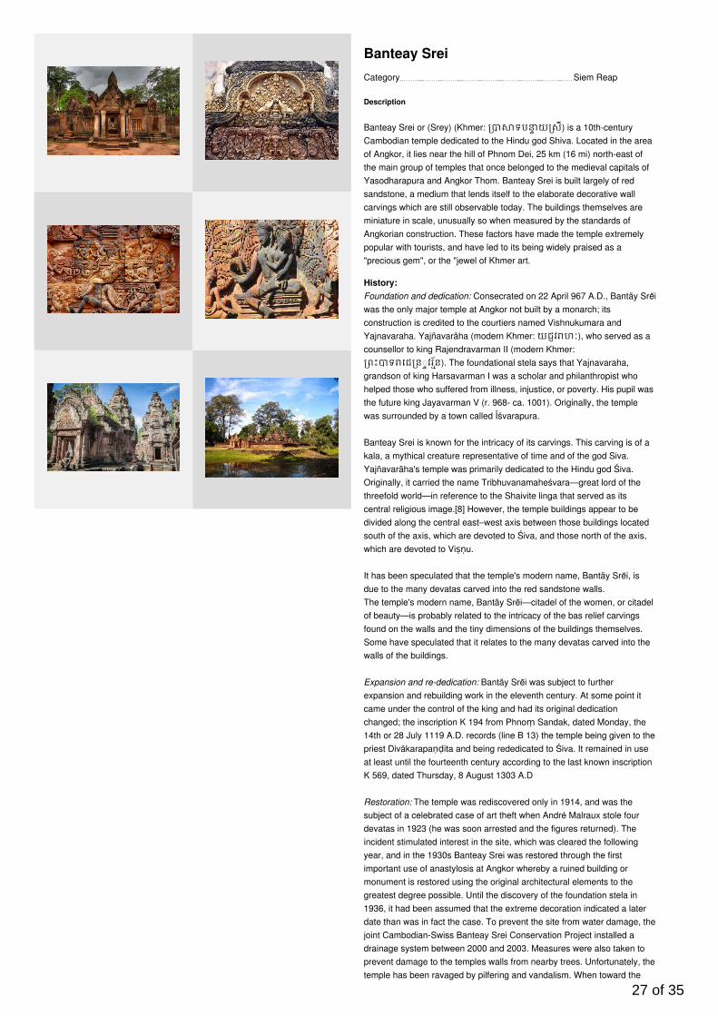
Banteay Srei
Description
Banteay Srei or (Srey) (Khmer: ទប យ សី) is a 10th-centuryCambodian temple dedicated to the Hindu god Shiva. Located in the areaof Angkor, it lies near the hill of Phnom Dei, 25 km (16 mi) north-east ofthe main group of temples that once belonged to the medieval capitals ofYasodharapura and Angkor Thom. Banteay Srei is built largely of redsandstone, a medium that lends itself to the elaborate decorative wallcarvings which are still observable today. The buildings themselves areminiature in scale, unusually so when measured by the standards ofAngkorian construction. These factors have made the temple extremelypopular with tourists, and have led to its being widely praised as a"precious gem", or the "jewel of Khmer art.
History:Foundation and dedication: Consecrated on 22 April 967 A.D., Bantãy Srĕiwas the only major temple at Angkor not built by a monarch; itsconstruction is credited to the courtiers named Vishnukumara andYajnavaraha. Yajñavarāha (modern Khmer: យជវ ហៈ), who served as acounsellor to king Rajendravarman II (modern Khmer:ពះ ទ េជ ន◌វរន័). The foundational stela says that Yajnavaraha,
grandson of king Harsavarman I was a scholar and philanthropist whohelped those who suffered from illness, injustice, or poverty. His pupil wasthe future king Jayavarman V (r. 968- ca. 1001). Originally, the templewas surrounded by a town called Īśvarapura.
Banteay Srei is known for the intricacy of its carvings. This carving is of akala, a mythical creature representative of time and of the god Siva.Yajñavarāha's temple was primarily dedicated to the Hindu god Śiva.Originally, it carried the name Tribhuvanamaheśvara—great lord of thethreefold world—in reference to the Shaivite linga that served as itscentral religious image.[8] However, the temple buildings appear to bedivided along the central east–west axis between those buildings locatedsouth of the axis, which are devoted to Śiva, and those north of the axis,which are devoted to Viṣṇu.
It has been speculated that the temple's modern name, Bantãy Srĕi, isdue to the many devatas carved into the red sandstone walls.The temple's modern name, Bantãy Srĕi—citadel of the women, or citadelof beauty—is probably related to the intricacy of the bas relief carvingsfound on the walls and the tiny dimensions of the buildings themselves.Some have speculated that it relates to the many devatas carved into thewalls of the buildings.
Expansion and re-dedication: Bantãy Srĕi was subject to furtherexpansion and rebuilding work in the eleventh century. At some point itcame under the control of the king and had its original dedicationchanged; the inscription K 194 from Phnoṃ Sandak, dated Monday, the14th or 28 July 1119 A.D. records (line B 13) the temple being given to thepriest Divākarapaṇḍita and being rededicated to Śiva. It remained in useat least until the fourteenth century according to the last known inscriptionK 569, dated Thursday, 8 August 1303 A.D
Restoration: The temple was rediscovered only in 1914, and was thesubject of a celebrated case of art theft when André Malraux stole fourdevatas in 1923 (he was soon arrested and the figures returned). Theincident stimulated interest in the site, which was cleared the followingyear, and in the 1930s Banteay Srei was restored through the firstimportant use of anastylosis at Angkor whereby a ruined building ormonument is restored using the original architectural elements to thegreatest degree possible. Until the discovery of the foundation stela in1936, it had been assumed that the extreme decoration indicated a laterdate than was in fact the case. To prevent the site from water damage, thejoint Cambodian-Swiss Banteay Srei Conservation Project installed adrainage system between 2000 and 2003. Measures were also taken toprevent damage to the temples walls from nearby trees. Unfortunately, thetemple has been ravaged by pilfering and vandalism. When toward the
27 of 35
end of the 20th century authorities removed some original statues andreplaced them with concrete replicas, looters took to attacking thereplicas. A statue of Shiva and his shakti Uma, removed to the NationalMuseum in Phnom Penh for safekeeping, was assaulted in the museumitself.
Category Siem Reap
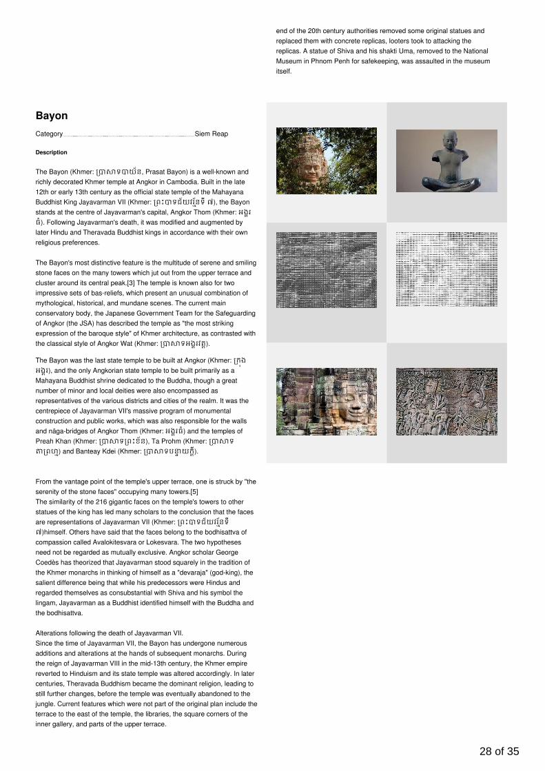
Bayon
Description
The Bayon (Khmer: ទ យ័ន, Prasat Bayon) is a well-known andrichly decorated Khmer temple at Angkor in Cambodia. Built in the late12th or early 13th century as the official state temple of the MahayanaBuddhist King Jayavarman VII (Khmer: ពះ ទជ័យវរន័ទី ៧), the Bayonstands at the centre of Jayavarman's capital, Angkor Thom (Khmer: អងរធំ). Following Jayavarman's death, it was modified and augmented bylater Hindu and Theravada Buddhist kings in accordance with their ownreligious preferences.
The Bayon's most distinctive feature is the multitude of serene and smilingstone faces on the many towers which jut out from the upper terrace andcluster around its central peak.[3] The temple is known also for twoimpressive sets of bas-reliefs, which present an unusual combination ofmythological, historical, and mundane scenes. The current mainconservatory body, the Japanese Government Team for the Safeguardingof Angkor (the JSA) has described the temple as "the most strikingexpression of the baroque style" of Khmer architecture, as contrasted withthe classical style of Angkor Wat (Khmer: ទអងរវត).
The Bayon was the last state temple to be built at Angkor (Khmer: កងអងរ), and the only Angkorian state temple to be built primarily as aMahayana Buddhist shrine dedicated to the Buddha, though a greatnumber of minor and local deities were also encompassed asrepresentatives of the various districts and cities of the realm. It was thecentrepiece of Jayavarman VII's massive program of monumentalconstruction and public works, which was also responsible for the wallsand nāga-bridges of Angkor Thom (Khmer: អងរធំ) and the temples ofPreah Khan (Khmer: ទ ពះខ័ន), Ta Prohm (Khmer: ទពហ) and Banteay Kdei (Khmer: ទប យកី).
From the vantage point of the temple's upper terrace, one is struck by "theserenity of the stone faces" occupying many towers.[5]The similarity of the 216 gigantic faces on the temple's towers to otherstatues of the king has led many scholars to the conclusion that the facesare representations of Jayavarman VII (Khmer: ពះ ទជ័យវរន័ទី៧)himself. Others have said that the faces belong to the bodhisattva ofcompassion called Avalokitesvara or Lokesvara. The two hypothesesneed not be regarded as mutually exclusive. Angkor scholar GeorgeCoedès has theorized that Jayavarman stood squarely in the tradition ofthe Khmer monarchs in thinking of himself as a "devaraja" (god-king), thesalient difference being that while his predecessors were Hindus andregarded themselves as consubstantial with Shiva and his symbol thelingam, Jayavarman as a Buddhist identified himself with the Buddha andthe bodhisattva.
Alterations following the death of Jayavarman VII.Since the time of Jayavarman VII, the Bayon has undergone numerousadditions and alterations at the hands of subsequent monarchs. Duringthe reign of Jayavarman VIII in the mid-13th century, the Khmer empirereverted to Hinduism and its state temple was altered accordingly. In latercenturies, Theravada Buddhism became the dominant religion, leading tostill further changes, before the temple was eventually abandoned to thejungle. Current features which were not part of the original plan include theterrace to the east of the temple, the libraries, the square corners of theinner gallery, and parts of the upper terrace.
28 of 35
en.wikipedia.org/wiki/Bayon
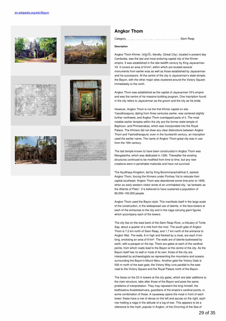
Category Siem Reap
Angkor Thom
Description
Angkor Thom Khmer: (អងរធំ), literally: (Great City), located in present dayCambodia, was the last and most enduring capital city of the Khmerempire. It was established in the late twelfth century by King JayavarmanVII. It covers an area of 9 km², within which are located severalmonuments from earlier eras as well as those established by Jayavarmanand his successors. At the centre of the city is Jayavarman’s state temple,the Bayon, with the other major sites clustered around the Victory Squareimmediately to the north.
Angkor Thom was established as the capital of Jayavarman VII’s empireand was the centre of his massive building program. One inscription foundin the city refers to Jayavarman as the groom and the city as his bride.
However, Angkor Thom is not the first Khmer capital on site.Yasodharapura, dating from three centuries earlier, was centered slightlyfurther northwest, and Angkor Thom overlapped parts of it. The mostnotable earlier temples within the city are the former state temple ofBaphuon, and Phimeanakas, which was incorporated into the RoyalPalace. The Khmers did not draw any clear distinctions between AngkorThom and Yashodharapura: even in the fourteenth century, an inscriptionused the earlier name. The name of Angkor Thom-great city was in usefrom the 16th century.
The last temple known to have been constructed in Angkor Thom wasMangalartha, which was dedicated in 1295. Thereafter the existingstructures continued to be modified from time to time, but any newcreations were in perishable materials and have not survived.
The Ayutthaya Kingdom, led by King Borommarachathirat II, sackedAngkor Thom, forcing the Khmers under Ponhea Yat to relocate theircapital southeast. Angkor Thom was abandoned some time prior to 1609,when an early western visitor wrote of an uninhabited city, “as fantastic asthe Atlantis of Plato”. It is believed to have sustained a population of80,000–150,000 people.
Angkor Thom used the Bayon style. This manifests itself in the large scaleof the construction, in the widespread use of laterite, in the face-towers ateach of the entrances to the city and in the naga-carrying giant figureswhich accompany each of the towers.
The city lies on the west bank of the Siem Reap River, a tributary of TonleSap, about a quarter of a mile from the river. The south gate of AngkorThom is 7.2 km north of Siem Reap, and 1.7 km north of the entrance toAngkor Wat. The walls, 8 m high and flanked by a moat, are each 3 kmlong, enclosing an area of 9 km². The walls are of laterite buttressed byearth, with a parapet on the top. There are gates at each of the cardinalpoints, from which roads lead to the Bayon at the centre of the city. As theBayon itself has no wall or moat of its own, those of the city areinterpreted by archaeologists as representing the mountains and oceanssurrounding the Bayon’s Mount Meru. Another gate-the Victory Gate is500 m north of the east gate; the Victory Way runs parallel to the eastroad to the Victory Square and the Royal Palace north of the Bayon.
The faces on the 23 m towers at the city gates, which are later additions tothe main structure, take after those of the Bayon and pose the sameproblems of interpretation. They may represent the king himself, thebodhisattva Avalokiteshvara, guardians of the empire’s cardinal points, orsome combination of these. A causeway spans the moat in front of eachtower: these have a row of devas on the left and asuras on the right, eachrow holding a naga in the attitude of a tug-of-war. This appears to be areference to the myth, popular in Angkor, of the Churning of the Sea of
29 of 35

Milk. The temple-mountain of the Bayon, or perhaps the gate itself, wouldthen be the pivot around which the churning takes place. The nagas mayalso represent the transition from the world of men to the world of thegods (the Bayon), or be guardian figures. The gateways themselves are3.5 by 7 m, and would originally have been closed with wooden doors.The south gate is now by far the most often visited, as it is the mainentrance to the city for tourists.
At each corner of the city is a Prasat Chrung-corner shrine built ofsandstone and dedicated to Avalokiteshvara. These are cruciform with acentral tower and orientated towards the east.Within the city was a system of canals, through which water flowed fromthe northeast to the southwest. The bulk of the land enclosed by the wallswould have been occupied by the secular buildings of the city, of whichnothing remains. This area is now covered by forest.
Most of the great Angkor ruins have vast displays of bas-relief depictingthe various gods, goddesses, and other-worldly beings from themythological stories and epic poems of ancient Hinduism (modified bycenturies of Buddhism). Mingled with these images are actual knownanimals, like elephants, snakes, fish, and monkeys, in addition to dragon-like creatures that look like the stylized, elongated serpents (with feet andclaws) found in Chinese art.
But among the ruins of Ta Prohm, near a huge stone entrance, one cansee that the “roundels on pilasters on the south side of the west entranceare unusual in design.”
What one sees are roundels depicting various common animals-pigs,monkeys, water buffaloes, roosters and snakes. There are nomythological figures among the roundels, so one can reasonably concludethat these figures depict the animals that were commonly seen by theancient Khmer people in the 12 century.
Category Siem Reap
Angkor Wat
Description
(Khmer: អងរវត or "Capital Temple") is a temple complex in Cambodiaand the largest religious monument in the world, on a site measuring162.6 hectares (1,626,000 m2; 402 acres). It was originally constructed asa Hindu temple of god Vishnu for the Khmer Empire, graduallytransforming into a Buddhist temple towards the end of the 12th century. Itwas built by the Khmer King Suryavarman II in the early 12th century inYaśodharapura (Khmer: យេ ធរបុរៈ, present-day Angkor), the capital ofthe Khmer Empire, as his state temple and eventual mausoleum. Breakingfrom the Shaiva tradition of previous kings, Angkor Wat was insteaddedicated to Vishnu. As the best-preserved temple at the site, it is theonly one to have remained a significant religious centre since itsfoundation. The temple is at the top of the high classical style of Khmerarchitecture. It has become a symbol of Cambodia, appearing on itsnational flag, and it is the country's prime attraction for visitors.
Angkor Wat combines two basic plans of Khmer temple architecture: thetemple-mountain and the later galleried temple. It is designed to representMount Meru, home of the devas in Hindu mythology: within a moat and anouter wall 3.6 kilometres (2.2 mi) long are three rectangular galleries, eachraised above the next. At the centre of the temple stands a quincunx oftowers. Unlike most Angkorian temples, Angkor Wat is oriented to thewest; scholars are divided as to the significance of this. The temple isadmired for the grandeur and harmony of the architecture, its extensivebas-reliefs, and for the numerous devatas adorning its walls.
Angkor Wat lies 5.5 kilometres (3.4 mi) north of the modern town of SiemReap, and a short distance south and slightly east of the previous capital,which was centred at Baphuon. In an area of Cambodia where there is an
30 of 35
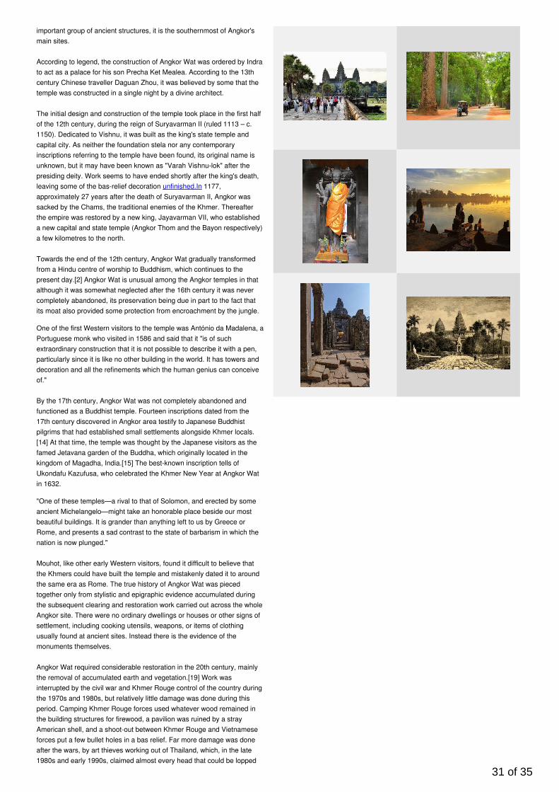
important group of ancient structures, it is the southernmost of Angkor'smain sites.
According to legend, the construction of Angkor Wat was ordered by Indrato act as a palace for his son Precha Ket Mealea. According to the 13thcentury Chinese traveller Daguan Zhou, it was believed by some that thetemple was constructed in a single night by a divine architect.
The initial design and construction of the temple took place in the first halfof the 12th century, during the reign of Suryavarman II (ruled 1113 – c.1150). Dedicated to Vishnu, it was built as the king's state temple andcapital city. As neither the foundation stela nor any contemporaryinscriptions referring to the temple have been found, its original name isunknown, but it may have been known as "Varah Vishnu-lok" after thepresiding deity. Work seems to have ended shortly after the king's death,leaving some of the bas-relief decoration unfinished.In 1177,approximately 27 years after the death of Suryavarman II, Angkor wassacked by the Chams, the traditional enemies of the Khmer. Thereafterthe empire was restored by a new king, Jayavarman VII, who establisheda new capital and state temple (Angkor Thom and the Bayon respectively)a few kilometres to the north.
Towards the end of the 12th century, Angkor Wat gradually transformedfrom a Hindu centre of worship to Buddhism, which continues to thepresent day.[2] Angkor Wat is unusual among the Angkor temples in thatalthough it was somewhat neglected after the 16th century it was nevercompletely abandoned, its preservation being due in part to the fact thatits moat also provided some protection from encroachment by the jungle.
One of the first Western visitors to the temple was António da Madalena, aPortuguese monk who visited in 1586 and said that it "is of suchextraordinary construction that it is not possible to describe it with a pen,particularly since it is like no other building in the world. It has towers anddecoration and all the refinements which the human genius can conceiveof."
By the 17th century, Angkor Wat was not completely abandoned andfunctioned as a Buddhist temple. Fourteen inscriptions dated from the17th century discovered in Angkor area testify to Japanese Buddhistpilgrims that had established small settlements alongside Khmer locals.[14] At that time, the temple was thought by the Japanese visitors as thefamed Jetavana garden of the Buddha, which originally located in thekingdom of Magadha, India.[15] The best-known inscription tells ofUkondafu Kazufusa, who celebrated the Khmer New Year at Angkor Watin 1632.
"One of these temples—a rival to that of Solomon, and erected by someancient Michelangelo—might take an honorable place beside our mostbeautiful buildings. It is grander than anything left to us by Greece orRome, and presents a sad contrast to the state of barbarism in which thenation is now plunged."
Mouhot, like other early Western visitors, found it difficult to believe thatthe Khmers could have built the temple and mistakenly dated it to aroundthe same era as Rome. The true history of Angkor Wat was piecedtogether only from stylistic and epigraphic evidence accumulated duringthe subsequent clearing and restoration work carried out across the wholeAngkor site. There were no ordinary dwellings or houses or other signs ofsettlement, including cooking utensils, weapons, or items of clothingusually found at ancient sites. Instead there is the evidence of themonuments themselves.
Angkor Wat required considerable restoration in the 20th century, mainlythe removal of accumulated earth and vegetation.[19] Work wasinterrupted by the civil war and Khmer Rouge control of the country duringthe 1970s and 1980s, but relatively little damage was done during thisperiod. Camping Khmer Rouge forces used whatever wood remained inthe building structures for firewood, a pavilion was ruined by a strayAmerican shell, and a shoot-out between Khmer Rouge and Vietnameseforces put a few bullet holes in a bas relief. Far more damage was doneafter the wars, by art thieves working out of Thailand, which, in the late1980s and early 1990s, claimed almost every head that could be lopped
31 of 35
off the structures, including reconstructions.
The temple is a powerful symbol of Cambodia, and is a source of greatnational pride that has factored into Cambodia's diplomatic relations withFrance, the United States and its neighbour Thailand. A depiction ofAngkor Wat has been a part of Cambodian national flags since theintroduction of the first version circa 1863.[21] From a larger historical andeven transcultural perspective, however, the temple of Angkor Wat did notbecome a symbol of national pride sui generis but had been inscribed intoa larger politico-cultural process of French-colonial heritage production inwhich the original temple site was presented in French colonial anduniversal exhibitions in Paris and Marseille between 1889 and 1937.Angkor Wat's aesthetics were also on display in the plaster cast museumof Louis Delaporte called musée Indo-chinois which existed in the ParisianTrocadero Palace from c.1880 to the mid-1920s.
The splendid artistic legacy of Angkor Wat and other Khmer monumentsin the Angkor region led directly to France adopting Cambodia as aprotectorate on 11 August 1863 and invading Siam to take control of theruins. This quickly led to Cambodia reclaiming lands in the northwesterncorner of the country that had been under Siamese (Thai) control sinceAD 1351 (Manich Jumsai 2001), or by some accounts, AD 1431.Cambodia gained independence from France on 9 November 1953 andhas controlled Angkor Wat since that time. It is safe to say that from thecolonial period onwards until the site's nomination as UNESCO WorldHeritage in 1992, this specific temple of Angkor Wat was instrumental inthe formation of the modern and gradually globalised concept of builtcultural heritage.
In December 2015, it was announced that a research team fromUniversity of Sydney had found a previously unseen ensemble of buriedtowers built and demolished during the construction of Angkor Wat, aswell as massive structure of unknown purpose on its south side andwooden fortifications. The findings also include evidence of low-densityresidential occupation in the region, with a road grid, ponds and mounds.These indicate that the temple precinct, bounded by moat and wall, maynot have been used exclusively by the priestly elite, as was previouslythought. The team used LiDAR, ground-penetrating radar and targetedexcavation to map Angkor Wat.
en.wikipedia.org/wiki/Angkor_Wat
32 of 35
Category Phnom Penh
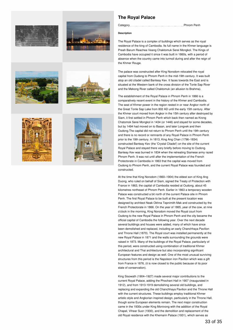
The Royal Palace
Description
The Royal Palace is a complex of buildings which serves as the royalresidence of the king of Cambodia. Its full name in the Khmer language isPreah Barum Reachea Veang Chaktomuk Serei Mongkol. The Kings ofCambodia have occupied it since it was built in 1860s, with a period ofabsence when the country came into turmoil during and after the reign ofthe Khmer Rouge.
The palace was constructed after King Norodom relocated the royalcapital from Oudong to Phnom Penh in the mid-19th century. It was builtatop an old citadel called Banteay Kev. It faces towards the East and issituated at the Western bank of the cross division of the Tonle Sap Riverand the Mekong River called Chaktomuk (an allusion to Brahma).
The establishment of the Royal Palace in Phnom Penh in 1866 is acomparatively recent event in the history of the Khmer and Cambodia.The seat of Khmer power in the region rested in or near Angkor north ofthe Great Tonle Sap Lake from 802 AD until the early 15th century. Afterthe Khmer court moved from Angkor in the 15th century after destroyed bySiam, it first settled in Phnom Penh which back then named as KrongChatomok Serei Mongkol in 1434 (or 1446) and stayed for some decades,but by 1494 had moved on to Basan, and later Longvek and thenOudong.The capital did not return to Phnom Penh until the 19th centuryand there is no record or remnants of any Royal Palace in Phnom Penhprior to the 19th century. In 1813, King Ang Chan (1796–1834)constructed Banteay Kev (the 'Crystal Citadel') on the site of the currentRoyal Palace and stayed there very briefly before moving to Oudong.Banteay Kev was burned in 1834 when the retreating Siamese army razedPhnom Penh. It was not until after the implementation of the FrenchProtectorate in Cambodia in 1863 that the capital was moved fromOudong to Phnom Penh, and the current Royal Palace was founded andconstructed.
At the time that King Norodom (1860–1904) the eldest son of King AngDuong, who ruled on behalf of Siam, signed the Treaty of Protection withFrance in 1863, the capital of Cambodia resided at Oudong, about 45kilometres northeast of Phnom Penh. Earlier in 1863 a temporary woodenPalace was constructed a bit north of the current Palace site in PhnomPenh. The first Royal Palace to be built at the present location wasdesigned by architect Neak Okhna Tepnimith Mak and constructed by theFrench Protectorate in 1866. On the year of 1865, year of the cow, at nineo'clock in the morning, King Norodom moved the Royal court fromOudong to the new Royal Palace in Phnom Penh and the city became theofficial capital of Cambodia the following year. Over the next decadeseveral buildings and houses were added, many of which have sincebeen demolished and replaced, including an early Chanchhaya Pavilionand Throne Hall (1870). The Royal court was installed permanently at thenew Royal Palace in 1871 and the walls surrounding the grounds wereraised in 1873. Many of the buildings of the Royal Palace, particularly ofthis period, were constructed using combination of traditional Khmerarchitectural and Thai architecture but also incorporating significantEuropean features and design as well. One of the most unusual survivingstructures from this period is the Napoleon iron Pavilion which was a giftfrom France in 1876, (it is now closed to the public because of its poorstate of conservation).
King Sisowath (1904–1927) made several major contributions to thecurrent Royal Palace, adding the Phochani Hall in 1907 (inaugurated in1912), and from 1913-1919 demolishing several old buildings, andreplacing and expanding the old Chanchhaya Pavilion and the Throne Hallwith the current structures. These buildings employ traditional Khmerartistic style and Angkorian inspired design, particularly in the Throne Hall,though some European elements remain. The next major constructioncame in the 1930s under King Monivong with the addition of the RoyalChapel, Vihear Suor (1930), and the demolition and replacement of theold Royal residence with the Khemarin Palace (1931), which serves as
33 of 35
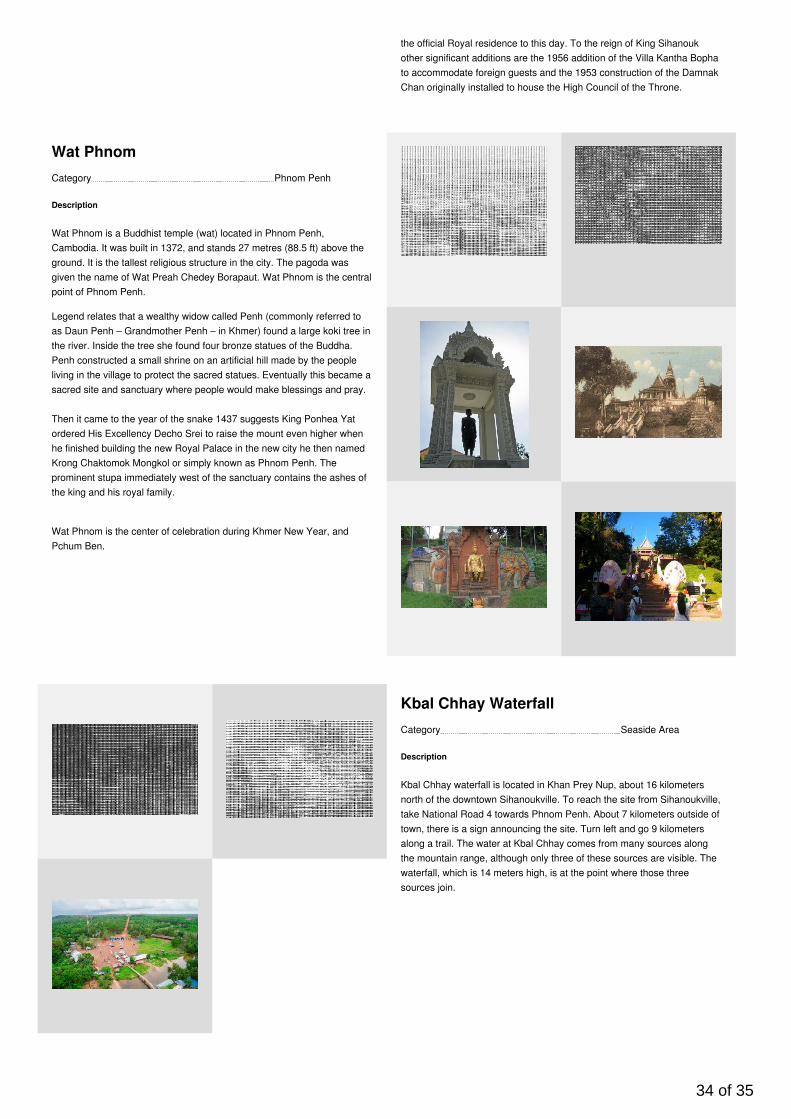
the official Royal residence to this day. To the reign of King Sihanoukother significant additions are the 1956 addition of the Villa Kantha Bophato accommodate foreign guests and the 1953 construction of the DamnakChan originally installed to house the High Council of the Throne.
Category Phnom Penh
Wat Phnom
Description
Wat Phnom is a Buddhist temple (wat) located in Phnom Penh,Cambodia. It was built in 1372, and stands 27 metres (88.5 ft) above theground. It is the tallest religious structure in the city. The pagoda wasgiven the name of Wat Preah Chedey Borapaut. Wat Phnom is the centralpoint of Phnom Penh.
Legend relates that a wealthy widow called Penh (commonly referred toas Daun Penh – Grandmother Penh – in Khmer) found a large koki tree inthe river. Inside the tree she found four bronze statues of the Buddha.Penh constructed a small shrine on an artificial hill made by the peopleliving in the village to protect the sacred statues. Eventually this became asacred site and sanctuary where people would make blessings and pray.
Then it came to the year of the snake 1437 suggests King Ponhea Yatordered His Excellency Decho Srei to raise the mount even higher whenhe finished building the new Royal Palace in the new city he then namedKrong Chaktomok Mongkol or simply known as Phnom Penh. Theprominent stupa immediately west of the sanctuary contains the ashes ofthe king and his royal family.
Wat Phnom is the center of celebration during Khmer New Year, andPchum Ben.
Category Seaside Area
Kbal Chhay Waterfall
Description
Kbal Chhay waterfall is located in Khan Prey Nup, about 16 kilometersnorth of the downtown Sihanoukville. To reach the site from Sihanoukville,take National Road 4 towards Phnom Penh. About 7 kilometers outside oftown, there is a sign announcing the site. Turn left and go 9 kilometersalong a trail. The water at Kbal Chhay comes from many sources alongthe mountain range, although only three of these sources are visible. Thewaterfall, which is 14 meters high, is at the point where those threesources join.
34 of 35
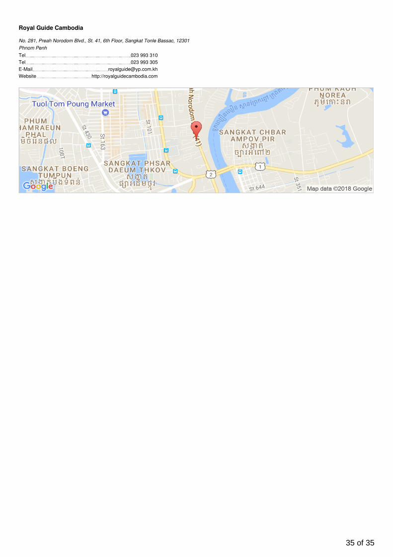
Tel 023 993 310Tel 023 993 305E-Mail [email protected] http://royalguidecambodia.com
Royal Guide Cambodia
No. 281, Preah Norodom Blvd., St. 41, 6th Floor, Sangkat Tonle Bassac, 12301Phnom Penh
35 of 35