Rowlands Castle - Liphookbramshottandliphook-pc.gov.uk/.../rowlands-castle-parish-plan-2008.pdf ·...
40
2008 - 2018 Rowlands Castle Parish Plan
Transcript of Rowlands Castle - Liphookbramshottandliphook-pc.gov.uk/.../rowlands-castle-parish-plan-2008.pdf ·...

2008 - 2018
Rowlands Castle
Parish Plan

Rowlands Castle Civil Parish
The maps in this Parish Plan are based on Ordnance Survey maps - Crown Copyright reserved. East Hants District Council -LC100024238-2008

Parish Plan 2008 - 2018 3
ContentsIntroduction 4
1. Summary 6
2. Rowlands Castle Parish: Location, Character, Boundaries & Identity
1. Location 8
2. Demographics 9
3. Character 10
4. Boundaries 11
5. Identity 12
3. Plan Process 13 4. Overview of Survey Results 16
5. Topics:
1. Living in Rowlands Castle 17
2. Environment 19
3 Transport, Traffic & Parking 21
4. Education 23
5. Housing 24
6. Services 26
7. Retail Services & Facilities 28
8. Sports & Recreation 31
9. Information & Communications 33
10. Local Government 34
11. For the Future 35
6. Community Strategy 36
Acknowledgements 38

Parish Plan 2008 - 20184
This is the first Parish Plan for the Parish of Rowlands Castle. The Parish comprises the village of Rowlands Castle, the hamlet of Finchdean, Idsworth estate, the scattered farms and cottages, and their surrounding countryside. It follows a successful Village Design Statement (VDS) published in 2000, and extends to cover those wider aspects also embraced by the District Community Strategies and the new Local Development Framework (LDF). The Plan was researched in 2007 and drafted in 2008.
The VDS which was the subject of consultation and subsequent adoption by both the Parish and East Hampshire District Councils, has been reviewed. In particular, some of the planning recommendations or guidelines (as highlighted in the VDS) have been consolidated and carried forward into this new Plan.
In correspondence with East Hampshire District Council, the advice received is that: “The Parish Plan is an important part of the evidence base for the Local Development Framework (LDF), for either the Core Strategy or more detailed allocations documents. It provides the best source of information about a local area. It will be essential that account is taken of this as the Council moves forward with the new LDF documents. Any work that has been undertaken by local people is clearly of considerable importance to us and means that we can find out the views of a wider number of local people that we may not normally be able to do. It is not a document that needs to be adopted as its value lies in its role as evidence. This would be the same in terms of the Community Strategy where officers can take account of what the Parish Plan says. The VDS has an important role to play in terms of the design and overall appearance of a local area. It is the design recommendations which are adopted and can be taken into account when considering planning applications. The 2 documents are, however, quite distinct and perform different roles. That is not to say that either has less standing. The Parish Plan will not be superceded by the VDS or visa versa. They will be used together”.
IntroductionThe Plan Steering Group has sought to communicate and to involve residents in this plan process by means of a structured questionnaire, by public briefings, informal meetings and public consultation on a draft of the Plan.
It is hoped that the Plan provides a comprehensive description of the circumstances of the Parish of Rowlands Castle, including the changes being experienced. It also attempts to look at some of the options to both protect those positive features that are treasured, and to address negative aspects of concern or anxiety. A major objective of the Plan when envisaging any new development will be at least to maintain and even enhance the character of the Parish as a place to live.
While trying to capture the particular ambience of the Parish as identified by residents, the Plan is intended to inform other ‘stakeholders’ including the Parish, District and County Councils about the residents’ needs and aspirations.
The Summary provides an overview of the Actions and Projects that were identified from the responses to the questionnaire. This Summary is based on an ‘Overarching Objective’ that, in turn, is supported by three ‘Aims’. It is intended that some of these Actions and Projects will provide the basis for influencing the drafting of both the Local Development Framework (LDF) and the Sustainable Community Strategy (SCS) and may also stimulate local initiatives within The Parish.
If the Plan also encourages more volunteers to come forward for local councils, clubs and associations, or volunteers to engage in ‘action’ or project groups, albeit only intermittently, it will have made a further important contribution to village life.
It is intended that the Plan will evolve in response to changing circumstances. For this reason a detailed ‘Action Plan’ will also be developed, which will be monitored and updated regularly. As the ‘Action Plan’ will be a “working” document, it will form a Supplement to this Parish Plan.
Parish Plan Steering Group
The Green, Rowlands Castle - New Years Day 2000

Parish Plan 2008 - 2018 5
Aerial view of Rowlands Castle Village

Parish Plan 2008 - 20186
This summary provides an overview of the Actions and Projects that were identified from the responses to the questionnaire. The Summary is based on an ‘Overarching Objective’ that, in turn, is supported by three ‘Aims’. The Steering Group believes that the ‘Objective’ and ‘Aims’ will help maintain the identity of Rowlands Castle Parish as a satisfying place to live in the longer term.
Furthermore, the ‘Objective’ and ‘Aims’ of the Parish Plan are fully in line with the existing Village Design Statement (VDS, 2000) that was approved and used as ‘supplementary planning guidance’ by both Parish and District Councils. The Plan and VDS documents are considered as complementary to each other.
Implementation of the Actions and Projects identified in the Plan will inevitably involve a much broader scope of work than is outlined below; some actions may be quickly initiated whilst others will require many years to bring to completion. The Plan will also need to evolve in response to changing circumstances. For this reason a detailed ‘Action Plan’ will be developed, which will be monitored and updated regularly. As the ‘Action Plan’ will be a “working” document, it will form a Supplement to this Parish Plan.
1.1. Overarching ObjectiveTo guide and influence the future of the Parish of Rowlands Castle, to preserve and enhance the character and distinctiveness of the natural and built environment, and improve it as a community where most residents are very satisfied to live.
1. Summary
1.2. Aims
I. To preserve and enhance the character and distinctiveness of the natural and built environment.
Actions & Projects• The aquifer protection zones within the Parish must be
respected and protected.
• Land subject to groundwater or flash flooding must be avoided for new development.
• The countryside gaps, and in particular the Havant Gap, are fundamental in maintaining the Parish character and should be retained.
• The village greens at both Rowlands Castle and Finchdean, should be improved as central features of the community
• Establishment of the South Downs National Park is to be supported, as it will protect the rural landscape. Its potential to improve Parish facilities and the locality should be investigated and pursued.
• Further development of Southleigh Forest Landfill site should be resisted. On completion of commercial activities the site should be restored to open woodland as specified in planning consent.
• Other landfill and mineral extraction around the Parish should also be resisted.
• The impact of traffic should be reduced. Specifically,
i. Lorry weight & width restrictions should be applied to appropriate roads within the Parish.
ii. The Green should be protected from encroachment by traffic.
iii. New landscaped car parking should be provided near the Green.
iv. The traffic impact from any new developments on existing roads must be fully assessed.
v. The traffic impact of the proposed reservoir construction and its use as a recreational facility should be evaluated and appropriate measures undertaken to mitigate adverse traffic effects.
• Any new developments should enhance the community quality and environment. Specifically,
i. New developments must provide a mix of affordable, small family houses and retirement housing or flats.
ii. New developments, particularly with retirement flats, must have good access to existing shops or make similar provisions.
• Improvements need to be made to the state of roads, pavements and lighting in the parish.

Parish Plan 2008 - 2018 7
II. To improve the Parish as a community where most residents are very satisfied to live.
Actions & Projects• Continuing Parish involvement in the management
of the Sir George Staunton Country Park should be maintained.
• A regular programme of voluntary litter picking should be initiated.
• St John’s Primary School is important to the community; where applicable local policy should support this facility.
• The availability of local Adult Education facilities should be developed.
• Additional facilities for young children – nursery school, holiday play schemes, after school clubs – should be developed.
• The GP surgery is highly valued and should be supported.
• Concern regarding crime is high and needs attention.
i. A programme to understand and reduce the high levels of concern regarding crime is required. ii. The extension of the Neighbourhood Watch scheme to the rest of the Parish is to be encouraged.
• The provision of a public WC is desired.• Waste collection services need further justification and consultation.• Support for local shops should be encouraged. In particular, i. Easier access and adequate short stay parking should be provided near shops to facilitate usage. ii. Change of use for buildings from business to residential should only be granted in exceptional circumstances.• The Recreation ground, Pavilion and facilities should be supported and maintained.• Renovation and funding of the Parish Hall must be pursued. A sound business plan showing this project to be financially sustainable is a priority.
III. To address residents’ dissatisfaction that the planning system pays insufficient attention to local opinion.
Actions & Projects• Local Authorities should actively guide residents to help them understand the planning process and explain the opportunities for residents to influence it. They should also demonstrate how local opinion is sought and used to influence planning decisions.• Residents should be encouraged to take a greater interest in how their community is governed.
The Green, Finchdean
Parish Plan 2008 - 20188
2.Rowlands Castle Parish: Location, Character, Boundaries and Identity
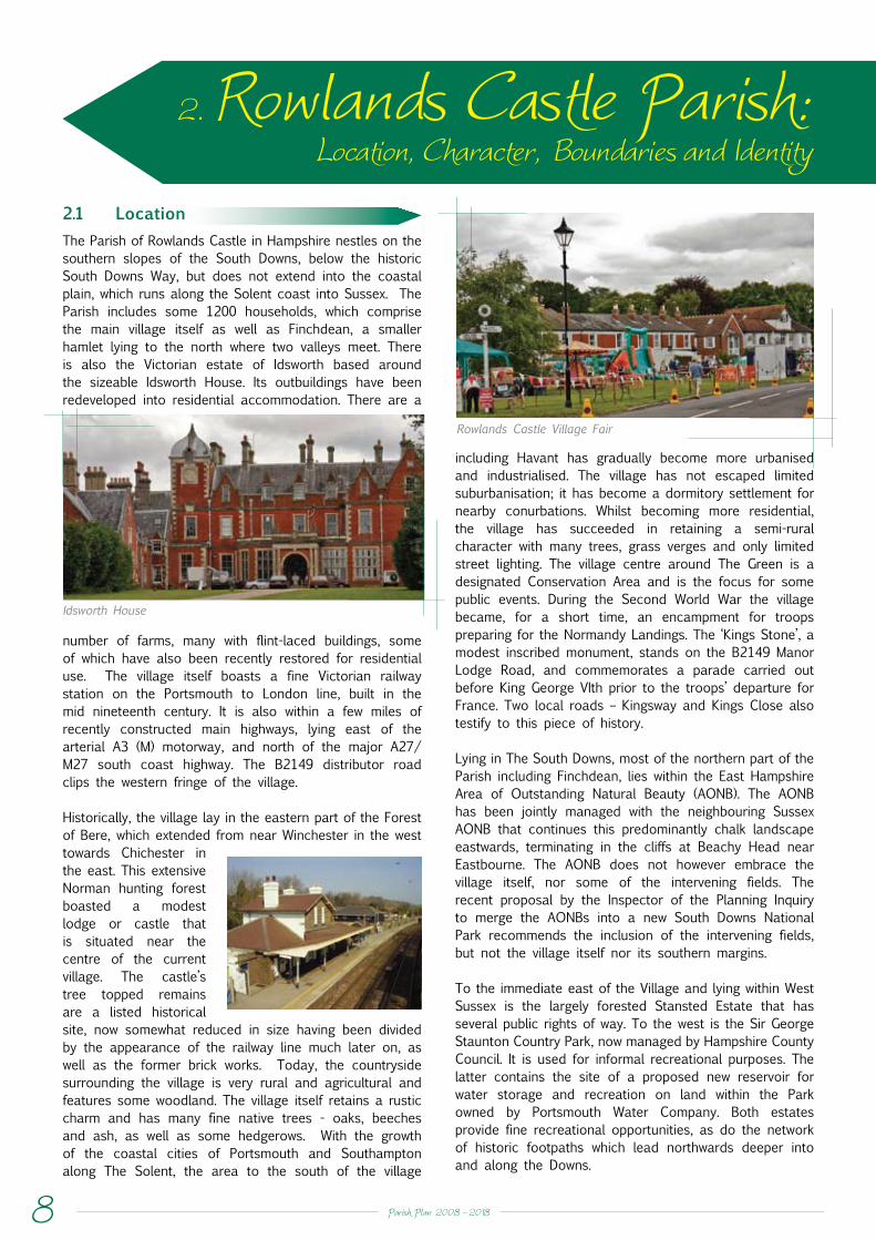
2.1 LocationThe Parish of Rowlands Castle in Hampshire nestles on the southern slopes of the South Downs, below the historic South Downs Way, but does not extend into the coastal plain, which runs along the Solent coast into Sussex. The Parish includes some 1200 households, which comprise the main village itself as well as Finchdean, a smaller hamlet lying to the north where two valleys meet. There is also the Victorian estate of Idsworth based around the sizeable Idsworth House. Its outbuildings have been redeveloped into residential accommodation. There are a
including Havant has gradually become more urbanised and industrialised. The village has not escaped limited suburbanisation; it has become a dormitory settlement for nearby conurbations. Whilst becoming more residential, the village has succeeded in retaining a semi-rural character with many trees, grass verges and only limited street lighting. The village centre around The Green is a designated Conservation Area and is the focus for some public events. During the Second World War the village became, for a short time, an encampment for troops preparing for the Normandy Landings. The ‘Kings Stone’, a modest inscribed monument, stands on the B2149 Manor Lodge Road, and commemorates a parade carried out before King George VIth prior to the troops’ departure for France. Two local roads – Kingsway and Kings Close also testify to this piece of history.
Lying in The South Downs, most of the northern part of the Parish including Finchdean, lies within the East Hampshire Area of Outstanding Natural Beauty (AONB). The AONB has been jointly managed with the neighbouring Sussex AONB that continues this predominantly chalk landscape eastwards, terminating in the cliffs at Beachy Head near Eastbourne. The AONB does not however embrace the village itself, nor some of the intervening fields. The recent proposal by the Inspector of the Planning Inquiry to merge the AONBs into a new South Downs National Park recommends the inclusion of the intervening fields, but not the village itself nor its southern margins.
To the immediate east of the Village and lying within West Sussex is the largely forested Stansted Estate that has several public rights of way. To the west is the Sir George Staunton Country Park, now managed by Hampshire County Council. It is used for informal recreational purposes. The latter contains the site of a proposed new reservoir for water storage and recreation on land within the Park owned by Portsmouth Water Company. Both estates provide fine recreational opportunities, as do the network of historic footpaths which lead northwards deeper into and along the Downs.
Rowlands Castle Village Fair
Idsworth House
number of farms, many with flint-laced buildings, some of which have also been recently restored for residential use. The village itself boasts a fine Victorian railway station on the Portsmouth to London line, built in the mid nineteenth century. It is also within a few miles of recently constructed main highways, lying east of the arterial A3 (M) motorway, and north of the major A27/M27 south coast highway. The B2149 distributor road clips the western fringe of the village.
Historically, the village lay in the eastern part of the Forest of Bere, which extended from near Winchester in the west towards Chichester in the east. This extensive Norman hunting forest boasted a modest lodge or castle that is situated near the centre of the current village. The castle’s tree topped remains are a listed historical site, now somewhat reduced in size having been divided by the appearance of the railway line much later on, as well as the former brick works. Today, the countryside surrounding the village is very rural and agricultural and features some woodland. The village itself retains a rustic charm and has many fine native trees - oaks, beeches and ash, as well as some hedgerows. With the growth of the coastal cities of Portsmouth and Southampton along The Solent, the area to the south of the village
Parish Plan 2008 - 2018 9
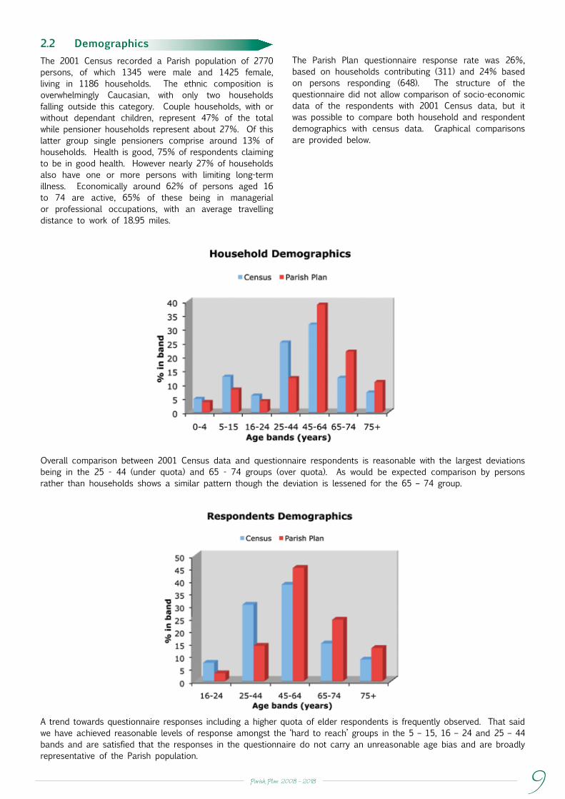
2.2 DemographicsThe 2001 Census recorded a Parish population of 2770 persons, of which 1345 were male and 1425 female, living in 1186 households. The ethnic composition is overwhelmingly Caucasian, with only two households falling outside this category. Couple households, with or without dependant children, represent 47% of the total while pensioner households represent about 27%. Of this latter group single pensioners comprise around 13% of households. Health is good, 75% of respondents claiming to be in good health. However nearly 27% of households also have one or more persons with limiting long-term illness. Economically around 62% of persons aged 16 to 74 are active, 65% of these being in managerial or professional occupations, with an average travelling distance to work of 18.95 miles.
The Parish Plan questionnaire response rate was 26%, based on households contributing (311) and 24% based on persons responding (648). The structure of the questionnaire did not allow comparison of socio-economic data of the respondents with 2001 Census data, but it was possible to compare both household and respondent demographics with census data. Graphical comparisons are provided below.
Overall comparison between 2001 Census data and questionnaire respondents is reasonable with the largest deviations being in the 25 - 44 (under quota) and 65 - 74 groups (over quota). As would be expected comparison by persons rather than households shows a similar pattern though the deviation is lessened for the 65 – 74 group.
A trend towards questionnaire responses including a higher quota of elder respondents is frequently observed. That said we have achieved reasonable levels of response amongst the ‘hard to reach’ groups in the 5 – 15, 16 – 24 and 25 – 44 bands and are satisfied that the responses in the questionnaire do not carry an unreasonable age bias and are broadly representative of the Parish population.

Parish Plan 2008 - 201810
2.3 CharacterThe landscape and topography of the Parish of Rowlands Castle are influenced by its geology. It is situated at the southern edge of the dip-slope of the South Downs chalk escarpment, where the chalk formation starts to dip southwards at a shallow angle beneath Tertiary sediments within the Forest of Bere basin. The later Tertiary formations, which outcrop in the southern part of the parish, include the Lambeth Formation (formerly known as the Reading Beds) and the London Clay Formation (formerly known as the London Clay). Both formations are predominantly formed of clay rich sediments, but there are also significant layers of sand in some areas. In the southeast part of the Parish, the London Clay Formation is more than 30m thick and is overlain in part by gravel deposits. At Southleigh Forest on the southern border of the Parish, the clay and gravel have both been excavated for use as construction materials, and the void space created has been utilised for solid waste disposal. This site is now almost full, and subject to restoration to wooded countryside. The geology is unusual, and has unique environmental significance. It gives rise to some hazards, including the seasonal lavants or streams, sink holes and other subsidence features, which may place constraints on development. The Countryside Design Summary (CDS) for East Hampshire places the Parish within Landscape Area 1 - ‘ the South Downs’, which is generally described as having distinctive chalk landscapes with rolling arable areas and is largely devoid of surface water, apart from a winter flowing stream (lavant), which runs occasionally in the valley through Finchdean to Rowlands Castle Village.
This description is, however, misleading for the area in the south of the Parish is occupied by the village and the remaining countryside to its south and west, where the chalk is overlain by impervious clay sediments or superficial deposits.
The northern part of the village has a variable thickness of clay, with flints lying on the chalk, but its southern part lies predominantly on the clay horizons of the Lambeth Formation. This means that surface water draining from both areas is directed towards the lower-lying ground in the centre of the village - along Redhill Road and The Green. These flows are sometimes augmented by springs issuing from sand horizons within the Lambeth Formation. Flash flooding and associated sewerage problems occur in this area immediately after periods of heavy rainfall.
The local geology also gives rise to an unusually large number of natural, circular, surface depressions called ‘dolines’. These are mainly sinkholes, produced by dissolution of the chalk and associated soil suffusion ground subsidence. They should not be used to accept surface water drainage, as water is the major factor in sinkhole formation and development. Additionally, surcharge and ground vibration from heavy vehicles can also result in ground collapse or subsidence over voids within the chalk or the cover deposits. This is probably the cause of a hole that appeared a few years ago in the road at Woodberry Lane. Because of its effect on ground subsidence, heavy goods traffic should be discouraged.
Lavant Flooding Across Woodberry Lane

Parish Plan 2008 - 2018 11
The Aquifer Protection Zones within the village must be respected and protected.
Many of these sinkholes also act as swallow-holes, allowing surface water to flow rapidly down into the Upper Chalk formation, which is a major groundwater aquifer - a critical source of local water supply - and constitute a significant groundwater pollution hazard. Some of these swallow- holes, such as the large one at the junction of Redhill Road and College Close, have been shown by tracer tests, to be directly linked by open fissure flow through the Upper Chalk to the Havant and Bedhampton Springs, which is a water supply source for over 200,000 people. The Kings Meadow estate at Redhill, constructed in the 1980s, increased water flow into this feature and significantly increased the environmental risk of both flooding and groundwater pollution. The original ditch along Castle Road has been replaced by large diameter pipe work, which acts as a balancing tank to mitigate flows.
The entire village, except for part of the Redhill area, is within the most sensitive of the aquifer protection zones (Zone 1- Inner Protection Zone) designated by the Environment Agency to protect water supplies.
Returning to the north of the Parish, a further unusual geological phenomenon is the periodic flooding and water pollution of the valleys through Finchdean and down to Rowlands Castle Village. In this case, after longer periods of heavy winter rainfall, increasing groundwater raises the water table in the chalk to the surface. The problem is exacerbated by inadequate drainage and sewerage provision by cess pits which over-fill. On average, heavy lavant flows have generally been expected every seven years, but groundwater and flooding appear to become more frequent and intense with climate change.
Historically, the development of Rowlands Castle Village has been closely associated with the extraction of clay, primarily from the Lambeth Formation (also called Reading beds), which outcrops in the south and west parts of the village. The clay was used for tile making in Roman times, and in the last two centuries for bricks. Rowlands Castle Brickworks ceased operation in 1967, and from 1971 to the present day, builders’ merchants have occupied part of the site. Although mainly out of sight, the resulting heavy traffic and noise are not suited to the narrower lanes in a rural village. A small demonstration building from the brickworks with examples of the various bricks and floral blocks once made, has been preserved, relocated, and reconstructed in the Brickworks Museum at Bursledon.
Land subject to groundwater or flash flooding must be avoided for any new developments.
2.4. Boundaries
Rowlands Castle Parish lies along the eastern boundary of Hampshire, adjacent to West Sussex. The Parish was created in 1932, once being part of Blendworth Parish. At a higher level, it was once part of Petersfield Rural District Council, but was subsumed into its successor East Hampshire District Council in 1974, where it is now the most southerly Parish.
Despite this, the Parish now finds itself in an ambiguous situation, as it is included within the ‘South Hampshire Sub-Region’ of the new South East Plan (Regional Spatial Strategy for the South East). On the one hand the Parish is part of predominantly rural East Hampshire, relating northwards to the South Downs and the Hangars, which are considered in the South East Plan as part of the ‘rest of the South East’. On the other hand, its location on the southern slopes of the Downs leads to its inclusion in the South Hampshire Sub-Region, with the expectation to improve its economic performance towards levels achieved by the Thames Valley and Oxfordshire Sub-Regions. Surprisingly, the delineation of these new sub-regional planning boundaries has not been the subject of a specific public consultation, so local people feel that they have been presented with a “fait accompli”. This contrasts with the extensive consultations about redrawing the Parliamentary Constituency, County Council electoral divisions and District Council ward boundaries.
(By way of clarification, the South East Plan has been submitted, in consultation draft, to the Government Office of the South East, and has been the subject of an Examination in Public (EiP) during 2006/7, with the Panel reporting its findings in late 2007. The Government’s response was published in the latter part of 2008. It will then be followed by a further period of consultation, leading to eventual Government adoption at which stage the Plan will become a statutory (legally enforceable) document).The new Local Development Framework (LDF) is being prepared by East Hampshire District Council, as the responsible authority, and has to interpret its relationship with the regional South East Plan. This will effectively require two plans – one for those parts of the Southern Parishes (Rowlands Castle, Horndean and Clanfield) that fall within the South Hampshire Sub-Region and another for the remainder of the District, which will also include parts of the Parishes of Rowlands Castle and Clanfield.

Parish Plan 2008 - 201812
From an environmental point of view, while the northern part of the Parish including Finchdean is already in the AONB, and included within the National Park proposal, there is one piece of interim good news in that the Inspector for the public inquiry into the proposed South Downs National Park has recommended that fields and woodlands immediately to the north of Rowlands Castle Village are also included within the Park. Importantly, this should give additional environmental protection to the countryside leading up to the village, and indeed, some added protection to the village itself. At this stage in the latest proposals, the village itself has not been proposed for inclusion within the Park, although it will have a ‘gateway’ role. Should there be a future opportunity to review boundaries of the Park, inclusion of the village as a whole, may be re-visited.
2.5 Identity
As described above, the Parish of Rowlands Castle has experienced many landscape and administrative changes over the years. It has traditionally been characterised by its rural setting featuring both arable and pastoral agriculture with woodlands that attract many recreational walkers. One of its main attractions is that it has not been absorbed into the coastal conurbation to the South.
Unsurprisingly, a survey of residents from all Parish households conducted in 2007 showed that 95% of respondents were very satisfied or satisfied with “The Parish as a place to live”. Moreover, 80% confirmed that the “village environment” was most important to them about the Parish. 70% indicated that “the countryside” was most important; 56% indicated the ‘village community’ was most important. There are, however, some issues that cause concern.
Looking Towards Forestside
Sussex Border Path

Parish Plan 2008 - 2018 13
3.1 Background
A Village Design Statement (VDS) for Rowlands Castle was published in the year 2000. The VDS, completed by a small steering group, was well presented and well received. It captured a number of concerns held by the Village population relating, in particular, to planning matters. The VDS was adopted by the Parish Council, and subsequently used as supplementary planning guidance to inform planning decisions by East Hampshire District Council.
With the focus subsequently changing at both local and national levels to a newer and more inclusive approach, supported by the Countryside Agency – the Government agency supervising such issues – the Parish Council sought to prepare a ‘Parish Plan’. It was intended to incorporate many of the features of the VDS, which had enjoyed much local support, as well as expand it to cover a wider range of topics.
Based on the successful experience of drafting the VDS, the Parish Council proposed an ‘arms-length approach’ to the preparation of a Parish Plan. A Parish Plan Steering Group of some eight volunteers was set up and initially included two Parish Councillors and two members of the Rowlands Castle Association (RCA) Committee. The Group met at monthly intervals to make progress with preparation and drafting of the Plan.
It was envisaged at the start that the Group would report back to the Parish Council: that the plan would be endorsed by the Parish Council, and then offered to the District and other councils and agencies for their use and guidance in community and planning matters and for supporting various local projects and initiatives as appropriate.
3. Plan Process
3.2 Survey of Residents
Early discussions on how to proceed revolved around either building on the VDS, undertaking a ‘Landscape Assessment’ - as had been done at Liss, another local council - or carrying out a survey of residents to understand the wider issues of both interest and of concern to residents.
At the end of 2006 a forty-question survey was conducted of all households in the Parish and the results were made available in March 2007. The survey was based on a computer package, ‘Village Appraisals for Windows’, produced by the Countryside and Community Research Unit at the University of Gloucester. Some questions were chosen from the menu offered in the package but these were supplemented by fourteen locally drafted questions. The software was utilised for data processing and printing graphics. A ‘comments’ facility was included.
The questionnaire achieved a twenty five percent response rate from all households canvassed –648 residents from the 311 households contributing. The questionnaire was pre-publicised and then circulated as an insert in the periodic delivery of the RCA Magazine. An article summarising results was published in the Spring 2007 edition of the magazine. A presentation of results was made to the Parish Council at one of its regular monthly meetings, and an invitation was received to include the presentation in the proceedings of the Annual Parish Meeting. During May, the Steering Group also arranged a ‘Drop-In Day’ at the Parish Hall, for residents to view the results and comments, and to contribute further thoughts on the Plan. In addition a stall was manned at the Village Fair on The Green in July 2007.

Parish Plan 2008 - 201814
3.3 Drafting the Plan
Presentations of the survey results were made to officers of the District Council, The Hampshire Constabulary and other agencies.
Of particular interest was the presentation by some members of the Group to officers of East Hampshire District Council. The Group was already aware that the Council had a ‘Community Strategy’ (CS) and was in the process of preparing a ‘Local Development Framework’ (LDF) to supersede the existing Local Plan. The Group wished to understand how the Parish Plan would relate to the District Council plans, with a view to influencing them favourably in the interests of the village.
The East Hampshire Community Strategy indicated the wider areas of interest to the District Council beyond strictly spatial planning matters. The LDD, however, was only in its early days so policy matters were not yet formalised. In spite of this the officers indicated that the Parish Plan would help, by drawing attention to topics that they might wish to include in their own plans. It also meant that the Parish Plan should be reviewed to reinforce any linkages between the Plan and any new policy initiatives emerging from the District Council.
3.4 Consulting on the Plan
Public consultation has taken place throughout the development of the Plan. This has included presentations, drop-in days, communications through the local residents magazine and publication on the Rowlands Castle Association web site.
Church on the Green
The Old School Playground - with Flint Laced Houses

Parish Plan 2008 - 2018 15
3.5 Making the Plan Work
The Plan was presented to the Parish Council for endorsement and support. They are expected to submit it to East Hampshire District Council, Hampshire County Council and other agencies to inform their own policy initiatives. At the same time, local groups and associations, or ad hoc groups, were encouraged to support, if not own, some of the actions and projects recommended in the Plan.
As it is expected that the Plan will evolve in response to changing circumstances, a detailed ‘Action Plan’ will be developed, monitored and regularly updated. The Parish Council will be responsible for this process. As the ‘Action Plan’ will be a “working” document, it will form a supplement to this Parish Plan.
The Green, Deer Leap Wall
Flint Laced Walls

Parish Plan 2008 - 201816
4. Overview Of Survey ResultsJust under a quarter of households in the Parish - 648 members from 311 households - responded to the questionnaire that was delivered in December 2006, as an insert in the winter issue of the RCA Magazine. Although a satisfactory response for this type of survey, the Steering Group would have preferred a larger response.
The large majority of respondents - 95% - are satisfied with Rowlands Castle ‘as a place to live’ - 58% were ‘very satisfied’ and 37% ‘satisfied’.
When asked ‘what is most important to you about the Parish?’ respondents indicated:
‘The Village Environment’ 78% ‘Access to the countryside’ 70% ‘The Village Community’ 56%
Other positive responses showed:
90% gave ‘good’ and ‘reasonable’ responses on ‘Views on the range of shopping facilities’
82% considered the standard of the ‘GP surgery’ was good or reasonable (For the most part presumably referring to the local practice)
90% felt that ‘the amount of ‘information available about events taking place in the parish’ was good or reasonable.
The more negative responses focused on traffic
82% considered ‘speeding traffic a problem’
83% agreed that there were ‘major danger spots on the roads in the parish’
38% felt that ‘the state of the pavements was poor’
36% said the same of ‘public toilets’
Crime and anti-social activities showed, in spite of low crime rates actually experienced: 65% concerned about ‘burglary’
64% about vandalism, but 11% ‘not concerned’
Looking ahead:
74% of respondents think that the Village should ‘stay as it is’
28% wanted there to be more ‘retirement homes’, while
27% wanted more ‘starter homes’.
Of the projects for the future, it was interesting to note that greater interest was shown in established activities, rather than newer ones
244 respondents sought ‘renovation of the Parish Hall’
222 ‘new public toilets’ and
214 ‘car parking near the Village centre’,
as against
194 ‘seeking access to the castle mound’
174 ‘extension of informal footpaths around the Village’
Under the ‘Information & Communication’ topic heading
77% of respondents indicated the RCA Magazine as a source of information
62% the Village shops, and 58% the Parish Council notice board, while only
7% have accessed the RCA website!
The following sections, 5.1 - 5.11, of this Plan elaborate on the interpretation of the data on a topic by topic basis, as presented in the questionnaire, and lead to further ‘action’ points for inclusion in the summary.

Parish Plan 2008 - 2018 17
5. Topics5.1. Living in Rowlands CastleThis topic comprised two questions:
i. An assessment of the overall satisfaction of residents with Rowlands Castle Parish as a place to live
ii. What is most important about the Parish ? (clarifying i. above)
The large majority, 95% of respondents are satisfied with the Parish ‘as a place to live’, with 58% being ‘very satisfied’, and 37% being ‘satisfied’. Less than 1% was either ‘dissatisfied’ or ‘very dissatisfied’!
When asked about ‘what is most important to you about the Parish’, 80% of respondents cited ‘The Village Environment’, 70% ‘Access to the countryside’ and 56% ‘the Village Community’ as being ‘most important’
These responses paint a picture of Rowlands Castle Parish, particularly the village, as a community, which is, on the whole, content with it as a place to live: are appreciative of its rural surroundings, and happy with opportunities within the community itself. Some of these positive features, such as the surrounding countryside, the village shops and school, for example, are explored under subsequent topics, as are more negative aspects such as concerns about traffic, speeding, parking and anti-social behaviour.
The village identity must be maintained.
Overall, there are aspects which are particular to Rowlands Castle Parish, and which are worth working to protect and enhance. The VDS of 2000 expressed this well:
“Rowlands Castle’s qualities, some obvious, some less tangible, combine to retain a village ambience and strong community spirit. Residents are in no doubt that this ‘sense of place’ comes from having a recognisable centre, the largest village green in Hampshire; there is a balance of open spaces, houses, trees and gardens and above all, a soft but distinct village edge”.
The Green, Rowlands Castle

Parish Plan 2008 - 201818
Options & ActionsIt is perhaps too early in this plan to elaborate fully on how ‘village identity’ must be maintained, but among options offered under subsequent topics, it becomes apparent that there are geographical and social aspects that will apply.
The countryside gaps between Rowlands Castle and other settlements are fundamental to maintaining the Parish’s semi-rural character. The gap separating the Parish from Havant is especially important and should not be compromised.
Within the village, the survey showed support for preservation of The Green, the central feature of Rowlands Castle Parish and a designated ‘Conservation Area’, especially as it is afflicted with traffic and parking issues.
The countryside gaps, and in particular the Havant Gap, are fundamental to maintaining Parish character and should be retained.
The village greens at both Rowlands Castle and Finchdean, should be improved as central features of the community.
The Green, Finchdean
The Rowlands Castle-Havant Gap viewed from the South
The Green, Rowlands Castle

Parish Plan 2008 - 2018 19
5.2. The Environment
In the questionnaire survey, five questions were asked about:
i. the importance of the countryside around the Parish
ii. elements of the countryside which are valued
iii. actions to help protect and enhance the environment
iv. whether the countryside had changed in recent years
v. what could be done to improve the landscape of the Parish
Responses to the first question about the countryside build on those already made under the initial topic ‘Living in Rowlands Castle’: 99% of respondents agreed that ‘the countryside around the Parish is important to me’: with 90% ‘strongly agreeing’ and 9% ‘agreeing’.
When asked ‘which elements of the countryside around the Parish do you value?’ 92% responded ‘local woodlands and forests’, 79% local footpaths, 71% ‘tranquillity’, 67% ‘a sense of place and locality’, and 66% ‘openness’.
In the Survey, residents were asked ‘what do you think should be done to help protect and enhance the environment?’
• 67% replied ‘regular litter picking’
• 61% ‘ reduced traffic’
• 43% ‘more recycling’
• 36% ‘ more public transport
• 32% ‘better flood protection’
In response to the question ‘Do you feel that the countryside around the Parish has changed in recent years?’ 53% said it had ‘not changed’, only 6% thought ‘for the better’, and 20% replied ‘for the worse’.
The question asking ‘what could be done to improve the landscape’ attracted replies showing that 72% of respondents thought that ‘regular maintenance of verges’ was ‘very important’ or ‘worth doing’, 64% thought ‘regular hedge cutting’, 62% ‘improve care of woodlands’, 56% ‘plant more trees’ and 40% ‘provide more footways’.
The Lavant

Parish Plan 2008 - 201820
On the southern boundary of the village is an extensive area of woodland, including some ‘ancient woodland’. Underlying the woodland and extending well to the east into West Sussex is a gravel train underlain by good quality clays. Within South Leigh Forest the gravel train has been worked and replaced by landfill operations, including land-raising and energy recovery. The currently approved area is now almost refilled and restoration is underway. However there are proposals to extend gravel, clay, landfill and waste processing operations along the southern boundary of the Parish. This relatively unnoticed part of the Parish landscape should benefit from restoration and be protected from further development.
Continuing Parish involvement in management of the Sir George Staunton County Park should be maintained.
Further development of Southleigh Forest landfill site should be resisted. On completion of commercial activities the site should be restored to open woodland as specified in planning consent.
Other landfill and mineral extraction around the Parish should also be resisted.
A regular programme of voluntary litter picking should be initiated.
As noted above, in answer to the question about improvements to the landscape, 67% of respondents thought a ‘regular programme of litter picking’ was important. Both the Parish Council and East Hampshire District Council already play a part in removing waste and litter. With litter and fly-tipping proving to be an ongoing challenge, a voluntary programme undertaken by volunteers from the whole community, and local groups, for example, the Scouts and Guides would instil a valuable lesson about civic responsibility to those young people who are members of these organisations.
Establishment of the South Downs National Park is to be supported, as it will protect the rural landscape.It’s potential to improve parish facilities and the locality should be investigated and pursued.
Options & Actions
A number of important actions are already undertaken and will help sustain an active influence on the countryside. But other programmes would also be helpful.
The Parish of Rowlands Castle is, indeed, fortunate to be surrounded by, and have access to, such lovely countryside, and welcomes the proposed creation of the South Downs National Park as a means to improve the protection already afforded by the East Hampshire Area of Outstanding National Beauty which the Park will supersede. Immediately over the border in West Sussex, to the east of the village, is the Stansted Estate, part of the Sussex AONB, and also in the proposed National Park. This is a well run forested estate with public rights of way, already enjoyed by residents.
Representations were made at the public inquiry into the South Downs National Park both by councillors and a supporting group of residents. The Inspector’s report recommended inclusion of the fields immediately to the north of the village, but not the village itself or the open land to the south. While the inclusion of the fields is welcomed, it is regretted that the village itself was not included. The village itself will continue to be a gateway to the National Park having both a bus route and a railway station.
A member of the Parish Council sits on the Management Committee of the Sir George Staunton Country Park, which manages the large tract of land to the west of the village, and is the location for the proposed new reservoir. The Park serves not only to protect the countryside to the west, but also provides an enjoyable amenity, particularly for children , and is run by Hampshire County Council
Proposed boundary of South Downs National Park before modification (shaded)
Addition 28 – June 2007.Now Includes The Holt & Surrounding Fields And Havant Thicket

Parish Plan 2008 - 2018 21
In summary, the survey responses demonstrated concerns about traffic speeds, danger-spots and congestion and parking problems.
Options & Actions
1. TransportRowlands Castle Village is well situated being away from, but with good access to main roads including the A27/M27 coastal dual carriage highway to the south, and to the main Portsmouth – London A3(M)/A3 highway to the west. It is linked to both of these corridors by the B2149 road that passes the western side of the village. Though the majority of transport need is met by car, public
5.3. Transport, Traffic and Parking
There were six questions in the survey on the topic of transport, traffic and parking:
i. Your main means of travel to work, study, shopping or leisure’.
ii. Experience of transport difficulties getting out of the Parish to other places’
iii. ‘Rating public parking facilities in the Parish’
iv. ‘Major danger spots on the roads in the Parish’
v. ‘Traffic is a problem’
vi. Assessment of support for a list of ‘speed control measures’
When asked ‘your main means of travel to work, study, shopping or leisure?’ the car was used by 88% of respondents, with walking coming a poor second with only 13%. The train was used by 10% and public bus by only 6%. Special bus or coach was cited by 1% (as for travel to school, for example) and taxi by 3%. This high and growing usage of cars does have consequences for traffic and parking in the village, as can be seen below.
When asked whether ‘you experience transport difficulties in getting out of the Parish to other places’, 50% responded ‘never’, 42% occasionally, and 7% ‘often’. Overall, access
to the village can be regarded as good.
Nevertheless, the road system within the village itself does give cause for concern. When asked whether they agreed that ‘there are major danger spots on the roads in the Parish?’
83% of respondents agreed –
44% ‘strongly agreed’ and 39% ‘agreed’
When asked a similar question about ‘speeding traffic in the Parish?’ 90% agreed – 45% ‘strongly agreed’ and 36% ‘agreed’
Asked whether residents ‘support the following speed control measures in the Parish?’
64% wanted ‘lorry weight restrictions’ 53% a ‘reduction in the speed limit’ 38% ‘traffic calming’ and 32% speed cameras or speed warnings’
Residents were also asked how they rated ‘public car parking facilities in the Parish?’ 40% thought they were ‘reasonable’, 36% thought they were ‘poor’, and only 11% thought they were ‘good’. Comments support this concern.
transport (rail, bus and taxis) is used by a significant minority and will continue to be very important to both residents and visitors. While the rail service is considered to be satisfactory, the bus service is extremely limited in both range of destinations and frequency. 2. Traffic
The B2149 effectively ‘cuts the corner’ between the A3(M) and the A27/M27 coastal highways which links to Havant. The B2149 is also a preferred route for heavy goods vehicles using the South Leigh Forest landfill site. Residents on the outskirts of the village living along the B2149 consider it to be a busy road, with complaints about speeding and vibration of their property due to heavy vehicles. The B2149 (Manor Lodge Road and Durrants Road) has a relatively narrow carriageway and footways. Together with generally high fences this results in wind turbulence that is of concern to the young mothers walking their children to school.
The B2148 (Whichers Gate Rd) runs between Rowlands Castle and Emsworth and has a heavy vehicle restriction due to a narrow hump-backed railway bridge. It passes the local school and the County Council, Governors and Parish Council are supporting a ’20 is plenty’ (20mph) speed limit to apply. However as a voluntary scheme, this is not legally enforceable
Manor Lodge Road Traffic

Parish Plan 2008 - 201822
To the north and east of the village are situated a series of pretty, rustic lanes linking into rural Sussex and the South Downs that are much used by ramblers and cyclists.
Speeding both within the village and around the Parish emerges, from the survey, as a major concern. The Parish Council supports the County Council Highway Authority in its village initiative for 30mph speed limits. This includes harmonising 30 mph speed limits with ‘natural’ entrances to villages. In tune with other national developments on speed limits, the conservation area around The Green might also be designated as a 20mph zone and delimited by soft landscaping and speed reduction at its ‘gateways’.
Within the village itself, a major cause of concern is the relatively large numbers of heavy delivery lorries (HGVs), most especially those delivering materials to the builders’ merchant and distribution centre in the old brick works. This is of particular concern to residents of Redhill Road and Castle Road. The village was represented at a Traffic Commissioners review of the site, but the review only covered lorries belonging to the builders’ merchant itself, and not to its customers or suppliers. Deliveries by HGV’s to retail premises surrounding the Green are also a growing concern. With the trend towards even heavier and larger lorries, it may be appropriate for the Parish Council to seek support and co-operation among other parish councils, particularly in Hampshire, to lobby for further restriction of HGVs on rural and village roads.
Lorry weight & width restrictions should be applied to appropriate roads within the Parish.
3. Parking
Congestion, due to traffic and parking in the area around The Green, Redhill Road and Castle Road are experienced. The regulation and management of traffic and the provision of additional parking might resolve this issue. However, as a designated ‘Conservation Area’ and as a central feature of the village with shops, public houses and periodic activities on The Green itself, there is a need to ensure that any measures do not interfere with pedestrian use.
The Green should be protected from encroachment by traffic.
Traffic management could include further short stay and provision of ‘resident parking’. The provision of further parking near The Green can only be provided on land that is not currently developed. However the Parish and District Councils are currently evaluating options.
As will be seen under ‘Facilities’ below, concern is expressed about the state of roads and footways and lighting. This maintenance issue does require a more systematic approach to set priorities within restricted funding, agreed by residents through the Parish Council and negotiated with the Highway Authority.
For the future, whilst pre-planning takes place for a reservoir and recreational facility in the Sir George Staunton Country Park on land already owned by Portsmouth Water Company, there is an issue of access to the site both for construction and for subsequent recreational use. With the A3(M) limiting options for access from the west, there is a possibility of access being required from the B2149. The opportunity for improving traffic flow past the west of the Village should be explored as part of the planning process
New landscaped car parking should be provided near The Green.
The traffic impact of the proposed reservoir construction and its use as a recreational facility should be evaluated and appropriate measures undertaken to mitigate adverse traffic effects.
Redhill Lorry Traffic
Parking On South Side Of Green

Parish Plan 2008 - 2018 23
5.4 Education
This topic addressed two items:
i. The importance of St John’s Primary School to the community
ii. The need for improved provision of educational services
St John’s Church of England (controlled) Primary School is the only educational institution in the Parish. In response to the statement “St John’s C of E primary School is important to the community’, 52% of respondents ‘strongly agreed’ while a further 34% ‘agreed’ with the statement. Less than 1% disagreed.
St John’s Primary School is important to the community; where applicable local policy should support this facility.
Older age groups will be educated outside the Parish; State schools include Staunton Park Community School, Horndean Technology College, Warblington School (Havant) and Oakland RC School (Purbrook). Independent schools include Portsmouth Grammar School, Portsmouth High School for Girls, St Johns College, Southsea (RC), Churchers College, Petersfield and Ditcham Park, Nr Petersfield. Havant, Petersfield and Portsmouth are accessible by public transport and Horndean College by school bus.
The second question asked whether there should be ‘more provision of the following’:
Nursery School 24% agreedPlaygroup 16% agreedMore registered childminders 10% agreed After-school clubs 39% agreedHoliday play schemes 32% agreed Adult education 61% agreed
Though this question offered a limited list of choices, a clear majority of respondents expressed a desire for provision of adult education facilities. Though such facilities are available in adjacent parishes and boroughs, access effectively requires travel by car, possibly a limiting factor for some Parish residents.
“There are many elderly residents who would welcome a range of courses. Currently we have to travel out of the village to participate in these activities which is difficult if courses are held at night as buses cease at 6pm and trains are one an hour.”
The availability of local Adult Education facilities should be developed.
There is also strong demand for after-school clubs, holiday play schemes and, at a lower level, a nursery school. In each case, this may reflect the importance of such facilities to young families. Transport may present difficulties for those facilities outside the Parish.
“Additional youth facilities are considered important – the new youth club is a good facility.”
Additional facilities for young children – nursery school, holiday play schemes, after school clubs – should be developed.
Options & Actions
St John’s school is highly regarded; it has a stable roll and receives strong support from the local education authority. Local policy should continue to support this facility.
Improvement to the provision of adult education was desired by a majority of respondents. However, the relatively small population (and possible lack of suitable facilities) suggests this may be hard to support within the Parish. Prior to proposing options, a firmer estimate of likely demand will be necessary, and an investigation into the provision of transport to existing adult education centres in Havant and Horndean. Short courses might be arranged in the Parish Hall. Horndean Technology College and village associations should be encouraged to extend provision of adult education.
Actions to provide facilities such as a nursery school, holiday play schemes and after school clubs are similar to those for adult education. The level of attendance is critical and in the past some previous facilities have had to close or relocate due to lack of local support. East Hampshire District Council has previously initiated some activities.
Overall comments regarding education were less than on most other topics. From a total of 26 comments 14 related directly to education, about a third were complimentary with the rest covering a range of topics. No overall theme was apparent

Parish Plan 2008 - 201824
5.5 Housing
Two matters were considered under this topic in the questionnaire:
i. Opinions on housing built during the last 10 years
ii. The kind of accommodation needed in future
The first question asked what residents “think about the number of houses that have been built in the Parish over the past ten years?” Responses showed that thought the number of houses:
45% ‘about right’ 28% ‘too much new housing’ 23% ‘too expensive’ 14% ‘no opinion’ 10% ‘too big’ 3% ‘too little housing’
2% ‘too small (in size)’
The second question asked, “What type of accommodation do you think the Parish needs?”The largest response was: 39% ‘no further homes are needed’
The other responses showed a mix of need for several types of housing:
28%‘ for retired people’ 28% ‘for starter homes’ 21% ‘for small family homes’ 20% ‘for affordable housing for key workers’ 11% ‘homes for single people’ 7% ‘homes for people with disabilities’ 6% ‘social housing’ 6% ‘large family homes’
5% ‘rental property’
In support of this response, the current EHDC Housing Needs Register 2007 for Rowlands Castle Parish identifies a need for 27 affordable homes for the area.
Rowlands Castle Parish has, in fact, a diversity of housing, concentrated on the village itself. 58% is comprised of semi-detached and terraced houses, flats and small senior citizens purpose built bungalows. But there are also a variety of detached properties comprising the rest.
House prices however are relatively high, showing a premium that reflects the desirability of the village for those wishing to enter the housing market.
During the past two years (well after completion of the Village Design Statement) the village has been included in the South Hampshire Sub-Region for the purposes of the South East Plan (RSS – Regional Spatial Strategy). As part of this Plan, the East Hampshire District’s Southern Parishes - Rowlands Castle, Clanfield and Horndean - are expected to meet planning proposals for 1200 new homes by 2026. While the South East Plan has yet to be ratified by Government, it is considered that this figure may increase.
Options & Actions
The Village Design Statement provided a good explanation of the current Parish settlement pattern.
“The aerial view of Rowlands Castle shows the settlement pattern is dominated by two triangles – formed by Links Lane, Bowes Hill and The Green, and by Redhill Road, Castle Road, and Manor Lodge Road respectively. Links Lane and Bowes Hill, which rise from the Green, contain predominantly individually designed detached houses and plots on Links Lane constitute a special feature of the village, recognised by designation of the area in the Local Plan as being of special housing character.”
It indicated that any future development should preserve the local gap between Rowlands Castle and Havant and nearby urban areas.
The extension of the AONB boundary by the proposed South Downs National Park to the north and east of the village, the Sir George Staunton Country Park to the west and the ‘Havant Gap’ along much of the southern boundary, already constrain opportunities for further development.
In 2005 the Inspector considered objections to the Local Plan. He recommended deleting the site at Deerleap and replacing it with a part brownfield site at Oaklands to accommodate 40 homes, this site being adjacent to Redhill Road. This recommendation was subsequently included in East Hampshire District Council’s Local Plan, 2nd review, as a reserve site. Nevertheless residents’ views, as already mirrored in the Village Design Statement, maintain that traffic congestion, arising from vehicles entering and exiting from near the brow of the hill in Redhill Road, would be unacceptable on an already busy road.
The countryside gaps, and inparticular the Havant Gap, are fundamental in maintaining Parish character and should be retained.
The traffic impact from any new developments on existing roads must be fully assessed.

Parish Plan 2008 - 2018 25
Other sites, however, have also been identified and they are adjacent to the above site, with Wimpey having an option on some of the land.
In addition to this, a site partially outside of the Settlement Policy Boundary, to the west of Manor Lodge Road opposite St John’s Church, covering approximately 6 acres, may be suitable as a rural exception site for affordable housing.
Any new developments must provide a mix of affordable, small family houses and retirement housing or flats.
The King’s Meadow Estate developed in the 1980s is a good example. This development on the outer fringe of the village, however, does not appear to integrate well, nor did it include additional convenience shopping facilities for that part of the village.
Any new developments, particularly with retirement flats, must have good access to existing shops or make similar provision.
Converted School
Traffic & Parking – Redhill Road
Converted School Farm Conversion

Parish Plan 2008 - 201826
5.6 Services
This topic addressed four items: i. The standard of the six main public
services
ii. Concern regarding crime and anti-social behaviour
iii. The state of Parish facilities
iv. Awareness of local waste disposal facilities
The majority of respondents rated the local services as either good or reasonable. On health care the GP surgery was rated as ‘good’ by 70% of respondents while 60% rated the hospital service as either good or reasonable. Ratings were lower for the remaining services (fire, police, ambulance, Social Services) while two, police and hospital, received a relatively higher level of ‘poor’ ratings (13% and 12% respectively).
In interpreting these responses it should be noted that three services had low levels of usage or experience by residents - ‘not used’ rates were 57% for ambulance, 67% for fire and 73% for Social Services. The ratings for the Police probably reflect the high levels of concern with crime (see following section).
The GP Surgery is highly valued and should be supported.
When asked ‘which, if any, of the following crimes and anti-social behaviour concern you in the Parish?’ very high levels of concern were expressed for burglary (65%), vandalism (64%), car crime (42%) and antisocial behaviour (45%). Concern with drunkenness was lower at 21%. These levels of concern appear disproportionate to the actual levels of crime or anti-social behaviour within the Parish, which are very low. With the possible exception of vandalism, it is plausible that respondents were responding to national levels of concern rather than to specific local issues. Nevertheless this is clearly an area that requires attention.
Comments on the state of a range of Parish facilities showed a wide range of opinion. The Village Green is highly regarded with 62% of respondents rating it as good. Roads, pavements, verges and street lighting were less well regarded, attracting poor ratings ranging from 22% to 38%.
“Roads and pavements in the Village generally are not in good condition.”
“Being mobility challenged I find the pavements very difficult to walk on, and when on a mobility scooter some places are terrifying.”
Few respondents recorded ‘no opinion’ except for the question of public toilets (44%). These were also rated ‘poor’ by 36%. The comments suggest this probably reflects a lack of awareness of the existence and/or location of the toilets and this is further discussed in Topic 11.
Asked if the local waste disposal facilities were adequately publicised, 76% of respondents replied yes. However ‘waste’ generated a high level of negative comment.
“Collection of non-recyclable waste fortnightly only is not sufficient, especially in warm weather. We have our own compost bins and little goes into the green bin, but it still gets very unpleasant after two weeks. Add another considerable health hazard!”
Rowlands Castle Surgery
Recycle Bins At the Rear Of Castle Inn

Parish Plan 2008 - 2018 27
Options & Actions
The survey identified three areas requiring action:
i. Levels of concern with crime and anti-social behaviour.
ii. The condition and adequacy of pavements, verges, roads and street lighting.
iii. Provision of public toilets
Concern with crime and anti-social behaviour appears disproportionate to local crime levels and may reflect the national debate over crime. Nevertheless it suggests that existing initiatives to improve the sense of safety within the community are falling well short of their intended goal. Understanding the basis of the concern – specific local events or a generalised national concern – is required and improvements to the existing community safety programmes made as appropriate.
An active Neighbourhood Watch scheme covers most of the Parish. The police communicate current issues to participants through this scheme.
The provision of a public WC is desired.
A programme to understand and reduce the high levels of concern regarding crime is required.
Extension of the Neighbourhood Watch scheme to the rest of the Parish is to be encouraged.
Improving the state of local roads, pavements and lighting may be easier to address as it appears to be driven by specific instances of poor maintenance or inadequate lighting rather than generalised dissatisfaction. One option would be to develop a detailed inventory of locations requiring maintenance and/or improvement and use this as a basis for developing a corrective programme in conjunction with the relevant public authorities; Parish residents could carry out such an inventory.
Improvements need to be made to the state of roads, pavements and lighting in the Parish.
‘Public toilets’ generated a high level of comment and an overall poor rating, promoting issues of both awareness and availability. Until recently the ‘Robin Hood’ public house adjacent to the village green provided a public WC, but the toilets are now only accessible when the pub is open. A study to identify possible sites/funding for provision of new public toilet facilities is indicated.
Though no question regarding the adequacy of local waste and refuse services were included 37% of the comments received related to this topic. Of these a considerable number concerned the introduction and/or inadequacy of bi-weekly collection of household waste, especially during the summer months. It is doubtful if this concern is confined to Rowlands Castle and it would appear appropriate for EHDC to conduct additional district surveys on this topic to better understand public acceptance. A trial of home composting of food waste is currently being conducted.
Waste collection services need further justification and consultation.
Looking Towards Green Neighbourhood Watch On The Green

Parish Plan 2008 - 201828
5.7 Retail Services & Facilities
The questionnaire survey asked about:
i. Usage of specific facilities ii. Views about the range of shopping facilities
Historically there has been a full range of retail outlets, as many as 39, stretching from Durrants and Redhill roads to the Green, Finchdean Road and on to Dean Lane End and Finchdean Village. With the development of surrounding towns, “out of town stores”, rail and bus services, and the advent of the motorcar, few shops remain.
“There used to be many more shops, but they were not used enough”
At present, Rowlands Castle Village is relatively well served with essential retail outlets, in the centre, on or near to the eastern end of the Green. These include a newsagents and general stores, hardware store which incorporates the Post Office, antique shop, bank, estate agent’s, servicing garage, café, veterinary services and three public houses with restaurants. At the other end of the Green is a hairdressing salon. Two builders’ merchants are located a quarter of a mile from the Green. Further facilities, including a servicing garage, petrol station (with shop for basic essentials) and a fourth public house, with nearby accommodation, are to be found at Whichers Gate, on the outskirts of the village, within reasonable walking distance for the residents on the southern edge. There is also an occasional mobile fishmonger. Neither Finchdean nor Idsworth have retail shops, although the former does have a public house.
Local services are generally well supported, given the proximity of larger retail outlets within a few miles. Village shops are used often by 82% of the respondents, with 17% occasionally and only 1% never. However, many residents choose to drive, take the bus or train to Havant, Horndean or further afield to Portsmouth and/or Chichester.
“It is not possible for the local shops to provide the variety and volume. It can be assumed that the bulk of our purchases are made outside the village. Local shops provide convenience – an important social role”
Some 90% of the respondents consider the range of shopping facilities as ‘good’ or ‘reasonable’, with only 9% as ‘poor’ and 1% with no opinion.
The hardware store is rated as ‘excellent’ and has a high profile in the surrounding area, attracting much custom from both in and outside of the village
Support for local shops should be encouraged.
The re-location of the Post Office, whilst not ideal for some residents, is used ‘often’ by 64%, and ‘occasionally’ by 32%. That these services were retained represents an important gain for the village.
There is praise for the enterprise shown by the new owner of the newsagents and general stores. 20% of received comments mentioned the lack of a greengrocer and particularly the lack of a butcher, following withdrawal of the mobile butcher. This has now been partially addressed by the improvement in the range of goods at the general stores. Re-instatement of the morning delivery of newspapers was also appreciated. Whilst this general store stocks basic medicinal remedies and the GP Surgery is self-dispensing, the lack of a chemist was mentioned by 10%. Chemists are located nearby in Leigh Park, Havant, Emsworth, Westbourne and Horndean.
Banking facilities appear to be adequate, with usage of Lloyds Bank and the cash dispenser at Shell Whichers Gate amounting to 15% ‘often’, 25% ‘occasionally’ and 60% ‘never’, as reflected in the bank’s decision to reduce the opening hours. Although not specifically questioned, many people use the facilities available at the Post Office. An ATM for out of hours use, located within the village, receives little support.
The servicing garages are well patronised, with 60% ‘often’ or ‘occasional’ use. There are many main agents in the locality, which would perhaps account for the remaining 40%.
The mobile library service appears to be under-utilised, with only 12% citing ‘often’ or ‘occasional’ use. It is to be hoped that the availability of larger libraries in Leigh Park and Havant does not lead to loss of this service, as it is our belief that this is an important facility for less mobile residents.
The public houses, restaurants and café are popular venues for the large number of visitors attracted by the Green and Stansted Park and, in addition, are used ‘often’ or ‘occasionally’ by more than 80% of respondents living in the village. Care should be taken that behaviour, noise, and other attendant nuisance should not be detrimental to the ambience of the Green.
“The Village should optimise the opportunity of more retail outlets. A full range of shops, pubs and restaurants are so important to the village”
“The amount of shops is just right and in keeping with the village image. We are lucky to have the facilities we have!”

Parish Plan 2008 - 2018 29The Castle Inn
The Fountain Inn
The Robin Hood Inn
The George Inn, FinchdeanRowlands Castle Hardware Shop and Post Office
Coffee Shop
Hall’s Garage
Castle Stores

Parish Plan 2008 - 201830
Options & Actions
To keep the village as a live community, any prospective business propositions should be encouraged, and be made aware of the Local Authority Growth Business Grant.
“It is vital for the survival of the village community that all current shops and businesses are fully supported and retained as they all provide the heart of the village and create the centre around the Green. So the ‘Conservation Area’ and businesses need to be protected for the future”
Change of use for buildings from business to residential should only be granted in exceptional circumstances.
The volume of traffic and amount of congestion on The Green, particularly in the restricted area outside the stores and at the junction with Bowes Hill and Woodbury Lane, is often acute. Parking problems are common and are exacerbated by large vehicles and buses as well as other everyday traffic. The provision of adequate short stay parking adjacent to the shops should help to increase their use. The Parish Council is already active in researching suitable sites. Traffic around the Green has been considered elsewhere with solutions being sought. For local businesses to continue to enjoy support, thrive and be successful, these issues are of the utmost importance.
Easier access and adequate short stay parking should be provided near shops to facilitate usage.
Congestion Outside Castle Stores

Parish Plan 2008 - 2018 31
5.8 Sports & Recreation
The questionnaire survey asked about,
i Use of Parish facilities
ii Opinion of the Parish Hall facilities
iii Opinion of the Recreation Ground facilities
iv Opinion of the Children’s Playground
Rowlands Castle within its Parish has the following facilities for sport and recreation: the Recreation Ground, Golf Club, Horse Riding Centre and numerous statutory and permissive country footpaths and bridleways for walkers. It is also adjacent to the Stansted Estate and the Sir George Staunton Country Park.
In addition to facilities mentioned above for those external pursuits, there are also indoor facilities at the Parish Hall, St John’s Church Hall, St John’s Primary School, the Hall at the Church on the Green and the Scout Hut off Uplands Road.
5.8.1 Sports
The Recreation Ground is the main venue for organised sports. It is equipped with an old pavilion that is in need of modernisation or rebuilding to meet current legislation and future sports’ demand. Adjacent to this is a children’s play area that features an assortment of obstacles and swings for children aged 11 and under.
The Recreation Ground also accommodates a tennis club; although private, it leases its site from the Parish Council and is open to the public two days a week. There are also two football clubs using the Recreation Ground and both have a thriving membership of adult and junior players made up of a balance of residents and non-residents. The cricket club has now relocated.
The Recreation Ground, Pavilion, and facilities should be supported and maintained.
In the questionnaire 61% of respondents replied that they used the Ground ‘often’ or ‘occasionally’. Their opinions of ‘the Recreation Ground sporting facilities’ showed that 56% thought them ‘good’ or ‘reasonable’. The children’s play area in the Recreation Ground was considered ‘good’ or ‘reasonable’ by 62%.
Rowland Castle Golf Club, a private members’ par 72 course, has been in existence for over a hundred years. It has a thriving membership, over 35% of who are local residents and boasts a modern clubhouse. It is a venue for various functions open to members and non-members alike.
Rowlands Castle Golf Club
Tennis Courts- Recreation Ground
Pavilion-Recreation Ground

Parish Plan 2008 - 201832
5.8.2 Recreation
Much informal recreation relates to enjoyment of the countryside throughout the Parish and surrounding the village in the foothills of the South Downs. Aspects of the countryside as seen by residents are described under the topic ‘Environment’.
Options & Actions
For a parish of its’ size, Rowlands Castle has a wide range of facilities for sport and recreation. However facilities such as the Parish Hall and Sports pavilion are in need of improvement within the short to medium term.
Renovation and funding of the Parish Hall must be pursued. A sound business plan showing this project to be financially sustainable is a priority.
Local support should be provided for the improvement of sports and recreation facilities.
Parish Hall
St John’s Church Hall
The village centre, being adjacent to the Stansted Estate, is often used as a meeting place for cyclists, walkers and ramblers. These groups benefit from the three public houses, all with restaurants and a café, which are adjacent to the Green. The Green is also used for the annual Summer Fair and May Day picnic. Church groups from within the village also use it for religious festivals. The Sir George Staunton Country Park is nearby.
“It is evident more and more people come to the village to use the walking and cycling facilities in the surrounding countryside. This benefits local shops, cafés, pubs!”
The Recreation Ground is used for the Guy Fawkes Bonfire Night and Fireworks display, organised by the Rowlands Castle Association.
The Parish Hall has two adjacent halls for hire that have kitchen facilities and it hosts a range of indoor recreations. It is managed independently from the Parish Council. The questionnaire replies stated that 70% of the respondents used the facilities of the hall and 64% thought the facilities ‘good’ or ‘reasonable’. The décor and outside of the hall, however, is in need of renovation.
In the questionnaire 35.1% of the respondents used the modern St John’s Hall, 15.2% of the respondents used the Church on the Green and St John’s School respectively whilst only 3.8% of respondents used the Scout Hut.
St John’s Church Hall is a large modern purpose-built hall used mostly by the churchgoers but is also open for public hire. The hall at the United Reform Church on the Green has limited floor space for meetings and functions. It has plans to extend its building to support more functions within the village. St John’s Primary School also offers its hall for after school activities and other evening functions.
The Scouts have their own ‘Hut’ that offers a venue to the various Cubs, Scouts, Brownies and Guides within the village and surrounding area.
May Day Picnic 2008

Parish Plan 2008 - 2018 33
5.9 Information & Communications
This topic addressed two items,
i. Sources of information regarding Parish events
ii. Opinions regarding the amount of information available
The survey showed that ‘the Village Community’ was important to 56% of respondents as affecting the village as a place to live.
Some further questions helped towards an insight into the meaning of this: 90% of respondents thought that ‘the amount of information available about Parish events’ was either ‘good’ (27%) or ‘reasonable’ (63%).
Asked ‘where do you usually get information about events taking place in the parish’ responses showed that residents got information from:
77% ‘the RCA Magazine 64% ‘local events boards or posters’ 62% ‘the Village Shops’ 58% ‘Parish Council notice boards’ 47% ‘the RCA notice board on The Green’ 27% ‘Meon Valley News’ - the local
free newspaper 7% only from the RCA website.
“The Rowlands Castle magazine is very good in my view to keep the community together and informed.”
In addition to the RCA Magazine the association also publishes an annual Village Directory.
Other factors affecting the sense of community included ‘sufficient awareness of local concerns about what is going on in the Parish’ by Parish Council representatives.
A more negative note was struck about satisfaction that ‘local opinion is sufficiently considered in the way the planning system is implemented in the Parish’ – an important matter during a period when the planning system is undergoing major changes. Only 25% of respondents were very satisfied or satisfied, 26% were neither satisfied nor dissatisfied, but 35% were dissatisfied or very dissatisfied.
Part of the challenge in preparing this Plan is that local people should have an understanding and interest in the matters proposed on their behalf. Considerable attention has been given to stimulating awareness, not always successfully. The questionnaire survey, feedbacks of results and consultation on the contents of the Plan itself have all been considered as important activities.
“Main events get well publicised such as Village Fayre and bonfire night, but smaller events ….. don’t get publicised unless you happen to know someone organising it.”
Options & Actions
Overall this section suggests that the information available to parishioners is considered sufficient. However it is noted that the Parish Council is considering the introduction of a newsletter later in 2008.
RCA Magazine
Parish Noticeboard On The Green

Parish Plan 2008 - 201834
5.10 Local Government
This topic addressed two items.
i. The awareness of electedrepresentatives to local concerns and feelings
ii. Satisfaction with consideration given to local opinion in the planning process
When asked if local government representatives are sufficiently aware of local concerns and feelings there was a clear decline in perceived awareness from Parish Council (33% ‘fully aware’) via District Council (10% ‘fully aware’) to County Council (8% ‘fully aware’). Overall Parish Council awareness was highly rated (74% ‘fully/quite aware’). 58% of respondents rated the District Council to be ‘fully/quite aware’ while 37% rated the County Council ‘fully/quite aware’. However a number of comments express cynicism as to whether this high awareness can influence the decision making process.
“Although I’m sure the Parish Councillors are aware of local opinion I’m convinced it will always be ignored by government.”
“Local and Council plans are being overridden by government and assembly quangos!!”
Asked whether local opinion is sufficiently considered in the way the planning system is implemented respondents expressed a much lower level of satisfaction. 25% said they were either ‘very satisfied’ or ‘satisfied’ compared with 35% that were either ‘dissatisfied’ or ‘very dissatisfied’ whilst a further 26% were ‘neither satisfied nor dissatisfied’. The mean response falls between ‘neither satisfied nor dissatisfied’ and ‘dissatisfied’.
“Planning driven by developers’ interest more than overall village interests as expressed in the Village Design Statement….Traffic and other infrastructure considerations for housing developments are considered in isolation from each other – i.e. little consideration of cumulative effect on village as a whole.” Options & Actions
Overall the local awareness ratings are good, especially at Parish Council level. The reduction in local awareness rating from Parish to District and on to County level is unsurprising and follows the shift of responsibility from local to regional matters. However satisfaction with the level of consideration given to local opinion in the planning process is poor; dissatisfaction exceeds satisfaction by a large margin. The results suggest that respondents are distinguishing between awareness and action, furthermore a number of their comments recognised that this is a result of central and regional policies taking priority over local input. However one recent high profile planning case was cited in several comments as indicating poor District Council involvement.
Fully addressing the expressed dissatisfaction with the planning system is difficult. Major changes have been introduced in recent years with the new Regional Spatial Strategy (RSS) – the South East Plan – having much wider scope than the former Regional Planning Guidance 9 (RPG9) and County Structure Plans that it replaced. Local Development Documents (LDDs) and Local Development Frameworks (LDFs) are similarly replacing Local Plans. Councillors, officers and residents all have to learn how the system should be implemented. Revising national planning policies so that local opinion is assigned more ‘weight’ would presumably be a solution, but is beyond the scope of a Parish Plan. Improved understanding and involvement in the planning system could help; making the process more transparent and encouraging residents to become more involved in how they are governed.
Though not strictly supported by the results of this questionnaire it is known that residents of the outlying regions of the Parish (Finchdean, Idsworth, Durrants) have expressed concern and/or dissatisfaction with the level of attention given to their needs. A small number of comments from the questionnaire also raise this issue.
“Finchdean has two pressing problems – flooding and the road surface in Ashcroft Lane. In general the Parish Council barely acknowledges Finchdean’s existence let alone listens to its concerns – let alone does anything about them.”
In part this reflects the relatively low numbers of parishioners located in the outlying areas but we believe that it has been exacerbated by recent Ward changes that have placed Finchdean within the Clanfield Ward. This has resulted in poor awareness of locally elected representatives who themselves are remotely located. The changes were made to balance Ward numbers and we now believe this should be reversed. Achieving effective representation should take precedence over numerical equalisation.
Local Authorities should actively guide residents to help them understand the planning process and explain the opportunities for residents to influence it. They should also demonstrate how local opinion is sought and used to influence planning decisions.
Residents should be encouraged to take a greater interest in how their community is governed.

Parish Plan 2008 - 2018 35
5.11 For the Future
This final section sought respondents input on two topics.
i. To indicate preferences for how the Parish should develop in the future
ii. To select from a list of projects those which could improve the quality of life in the Parish
Asked how the Parish should develop in the future 74% of respondents said it should ‘stay as it is’ though 25% suggested that it should develop more as a working community.
The second question asked respondents to select from a list of ten projects those that they would like to see undertaken to improve the quality of life in the Parish. Respondents were able to select multiple projects. The project ranking, in declining order, was as follows,
i. Renovation of the Parish Hall 47%ii. New Public Toilets 43%iii Car parking near village centre 41%iv. Seek public access to the Castle mound 37%v. An extension of informal footpaths or walks 34%vi. Recreational reservoir in Staunton Park 32%vii Bypass road to the west of the village 30%viii. Building a new Pavilion 28%ix A Village Museum (in the Railway Station?) 25%x. Acquisition of more public land within village 17%
“The Parish Hall badly needs renovating. It is tired. Probably more use would be made of it.”
In addition to the above a total of 71 comments were received of which approximately 30% concerned transport (mainly parking and traffic volume). The remaining comments covered a diverse range of topics with no overall theme appearing.
Options & Actions
The highest ranked project was the renovation of the Parish Hall, supported by approximately 47% of respondents. The need for renovation of the Parish Hall has been apparent for some time and a working group comprising members of the Parish Hall Management Committee and the Parish Council are working to develop a project plan and funding proposals. The results of the Parish Plan survey are supportive of this and will hopefully be of value in supporting applications for project funding.
The second and third ranking projects, provision of new public toilets and village centre car parking, are reviewed in sections 5.6 Services and 5.3 Transport, Traffic & Parking respectively.
Two further projects, access to the castle mound and extension of (informal) footpaths, received the support of a third or more of respondents. However it seems very unlikely that sufficient resources would be available to undertake these together with the higher ranked projects mentioned above. These should be noted as potential future projects and are also included in the Community section as they link in to local priorities being developed as part of the new Sustainable Community Strategy.
The character and distinctiveness of the village, its countryside and community should be preserved and enhanced.
Parish Hall

Parish Plan 2008 - 201836
Previous sections of this Plan provide background information about the Parish generally and, more particularly, describe the questionnaire survey with an interpretation of its results leading to possible options and actions. In this section about the ‘Community’ of Rowlands Castle the questionnaire responses are linked to similar work currently being undertaken within East Hampshire District Council (EHDC). In particular it relates to the framework used in ‘East Hampshire Sustainable Community Strategy (SCS) 2008-2026’. This new strategy has not yet been finalised, but a first draft has been published. Indeed, this latter document is a Government requirement, setting out policies that all local organisations within the District should work towards.
The earlier ‘East Hampshire District Community Strategy 2005-2015’ has a vision for East Hampshire:
‘A place where everyone is able to enjoy a high quality of life without adversely affecting future generations or other communities.’
‘By 2006, East Hampshire will be a better place where people live in safe, attractive and prosperous towns and villages. They will have good access to a range of housing, jobs, leisure and community facilities, and enjoy a high quality built and natural environment. They will live and work in a way that respects resources and the district’s natural environment.’
To develop and elaborate on this objective in the new Sustainable Community Strategy, EHDC have grouped those things that matter most to peoples’ quality of life into three groups:
1. Safe and Strong Communities 2. Economy and Education 3. Environment, Infrastructure and Transport
6.1 Safe and Strong Communities
In this Parish Plan, with regard to children and young people, there is a general theme of a lack or limited provision. St Johns School is considered important as it provides local education for the 5-11 year olds together with pre-school facilities for younger children and some vacation activities. Limited local childcare services are offered outside of the school, though availability has declined, and the need for improved provision has been noted.
Some social and sporting activities are provided for younger people. The local Scout and Guide groups have their own recently refurbished hall facilities. Local sporting clubs and associations – including golf, football and tennis - offer seasonal playing and coaching opportunities to younger
people. There is a one-day-a-week Youth Club, and both the Anglican and Evangelical churches offer various youth facilities for their members. Nevertheless there is concern that opportunities for teenagers outside of school are insufficient. Teenagers, particularly the 14-18 age group, lack a location where they can meet and socialise on a regular basis outside a structured ‘youth club’ environment.
Responses to the survey show surprisingly high concerns relating to crime and anti-social behaviour. In practice crime levels in the parish are very low, emphasising the importance of considering how perceptions of crime can be reduced while also seeking to reduce the actual level of crime itself. While the survey did not directly link young people with these concerns it is likely they are implicated, especially given the lack of off-street evening locations for local youths to gather.
Regarding housing, the need for more ‘affordable’ and ‘retirement’ homes was emphasised, as was the importance of providing retirement homes with good access to local facilities.
Supporting and maintaining the sports ground and pavilion recreation facilities was also important.
Some respondents commented that the outlying communities such as Finchdean were relatively overlooked in terms of Local Authority attention to matters such as road maintenance, traffic control and flood alleviation. It will be helpful to recognise this concern as a theme in the Community Strategy Action even though the Parish Council is seeking to address it.
The Old Forge Finchdean
6. Community Strategy
Parish Plan 2008 - 2018 37
6.2 Economy and Education
Employment is found overwhelmingly outside the parish, but the local village businesses and community services are shown in the survey to be important to parish residents. The need for these to be supported in terms of usage and also provision of suitable parking is strongly noted.
Many respondents requested improved provision of adult education. There is good formal provision at Havant College, South Downs College and Havant Technology College, all easily accessible by car. Some respondents commented, however, on the difficulty for the elderly in reaching these existing adult education locations.
6.3 Environment, Infrastructure and Transport
This section covers the majority of the issues identified by respondents. Access to an outstanding countryside and to services and leisure opportunities via good paths, roads and public transport were all identified as contributing to the high quality of life in Rowlands Castle. As the farming community and managers of large estates are the primary custodians of the countryside their ongoing support and involvement is essential. The proposed National Park will also have a significant role in supervising the countryside. Equally important was the need to maintain the Parish character and to resist creeping urbanisation particularly along its southern boundaries. All the above need to be recognised as both planning and community priorities.
Local environment priorities are also identified. Rowlands Castle draws its name from a Norman motte-and-bailey castle, allegedly a lodge for kings hunting in the ancient Forest of Bere. The remains are preserved as a listed historic monument and though now in private ownership, it may be possible to negotiate access and provide some interpretation linking the community to its name and its origins. Similarly the residents endorsed the extension of local footpaths and walks.
Infrastructure receives little mention in the District Council’s Sustainable Community Strategy. However responses to the survey for this Plan showed that satisfaction with the state of local infrastructure (roads, pavements, lighting) is poor and that these were considered to be in need of attention. Respondents also emphasised how important the Village Greens were to the community, both in terms of heritage and as recreational facilities – Rowlands Castle Green as a designated Conservation Area, and the pretty green at Finchdean.
Transport was also an issue, but concerns here related almost entirely to the disruptive affect that traffic volume, speed and heavy vehicles has on the community, rather than to improving access to public transport. While this topic receives little discussion in the Community Strategy, it seems unlikely that this concern is restricted to Rowlands Castle.
St Huberts Church - Old Idsworth

Parish Plan 2008 - 201838
This Parish Plan was written and produced by the Steering Group:
Alan DrinkwaterDave Harvey
Sandra HodgettsTony RixonChris White
Contributions by Peter McDowell & Peter Stitson
Photographs by Vera Whitlock Designs by Gareth Roberts and his team.
Support from the following organisations is acknowledged:
Rowlands Castle Parish Council
Rowlands Castle Parish Hall Management CommitteeRowlands Castle Association
East Hampshire District CouncilBishops Printers Ltd
Very many thanks to all those others, too numerous to mention, who helped along the way

Parish Plan 2008 - 2018 39
Prop
osed
Hav
ant Th
icket Winter Storag
e Re
servoir – co
urtesy P
ortsmou
th W
ater