ROV Hercules Investigates Brine Lakes on the Bottom of the ...
5
30 ROV Hercules Investigates Brine Lakes on the Bottom of the Ocean By Erik E. Cordes, Anna P.M. Michel, Jillian M. Petersen, Scott D. Wankel, Rebecca Ansorge, Peter R. Girguis, Nikolaus Leisch, Clara Smart, Chris Roman, Silke Wetzel, and Charles Vidoudez During two cruise legs of the 2015 E/V Nautilus field season, the remotely operated vehicle (ROV) Hercules was deployed to exam- ine some of the cold seep features of the deep Gulf of Mexico. Cold seeps are locations where hydrocarbons that are normally trapped deep beneath the seafloor escape into the water column. e hydrocarbons are forced out from the depths by the move- ment of large salt bodies that developed over the course of several million years as water evaporated from an ancient shallow Gulf of Mexico (Brooks et al., 1987). Shiſting of these salt layers produces cracks in the oil-bearing shale that provide pathways for upward migration of oil and gas. At some seep sites, deep within the sediments, the interaction of porewater and salt results in a highly saline fluid (brine) that can be more than four times more saline than seawater. When this brine is expelled from the sediments, it is far denser than the overlying seawater and does not mix very easily with it. In some cases, the brine forms large pools, or even rivers, as we discovered on one of the ROV dives at a site called Garden Banks 903. e dive started at the lower end of a canyon, where large mud flows were descending the steep slope. At the entrance to the canyon, we could see small carbonate outcrops and mussel beds containing Bathymodiolus childressi. As Hercules continued into the canyon, it encountered a very steep wall with what appeared to be flows of red, white, and yellow streaming over the edge (Figure 1). When Hercules crested this small wall, the cameras brought a pool of brine into view. e walls of the pool were made up of barite, a barium sulfate precipitate, and the red coloration was likely from high concentrations of iron in the fluids. e fluid also contained high concentrations of both sulfide and methane. As Hercules con- tinued up the brine river, there was evidence of flowing brine all along the narrow valley, with more pools at certain points where the flows were obstructed. Some were clear and white, and some had reddish walls indicative of iron precipitates. is site requires more study to understand what is happening in this environment. At active seep sites where methane and hydrogen sulfide are expelled at the sediment-water interface, large mussel beds can form (reviewed in Cordes et al., 2009). Here in the deep sea where food is generally scarce, bacterial symbionts in the mussels’ gills allow them to use dissolved gases being emitted at the seafloor as a source of energy. We collected mussels at two different sites. At the first site, lease block Mississippi Canyon 853, two species of mussels co-occurred on rough topography made up of small hills and valleys. e mussels and seep areas were mostly located at the bottoms of long trenches, and we flew Hercules through a few of them in search of a good sampling location, observing a few well-developed mussel beds along the way. Some contained both of our target species, B. childressi, along with its methane- oxidizing symbionts (Fisher et al., 1987), and Bathymodiolus brooksi, with multiple symbiont types (Duperron et al., 2007). e second mussel sampling site was at Green Canyon 234, one of the largest and best known seeps in the Gulf of Mexico. ere, a dense, football-field-size expanse of vestimentiferan tubeworms (with sulfide-oxidizing symbionts) blankets the seafloor. Beds of B. childressi mussels are found in some areas and carbonates with deep-sea corals (the sea fan Callogorgia delta) in others. In addi- tion, areas of outcropping gas hydrates are colonized by a unique species of polychaete worm, Hesiocaeca methanicola, known as the ice worm (Fisher et al., 2000). To better understand why these seep communities exist where they do—and why they are composed of different assemblages— we fitted Hercules with an in situ mass spectrometer (ISMS) and a laser spectrometer to provide real-time information on the chemical composition of the hydrocarbon seeps while we were exploring the sites. ese types of novel sensors also collect important information on the sources of these fluids and on the energy-rich compounds contained in them that allow these types of animals to thrive. To examine free-living and symbiotic microbial metabolisms and how they influence local carbon, nitrogen, and sulfur cycles, we employed the ISMS to analyze water samples for dissolved hydrogen, methane, sulfide, oxygen, and other volatile content. Preliminary analyses show elevated concentrations of dissolved sulfide and methane in the flowing brines, which constitute a conduit for the rapid transport of these reduced compounds Figure 1. A brine pool, with walls made up of barite. 30 30
Transcript of ROV Hercules Investigates Brine Lakes on the Bottom of the ...

30
ROV Hercules Investigates Brine Lakes on the Bottom of the OceanBy Erik E. Cordes, Anna P.M. Michel, Jillian M. Petersen, Scott D. Wankel, Rebecca Ansorge, Peter R. Girguis, Nikolaus Leisch, Clara Smart, Chris Roman, Silke Wetzel, and Charles Vidoudez
During two cruise legs of the 2015 E/V Nautilus field season, the remotely operated vehicle (ROV) Hercules was deployed to exam-ine some of the cold seep features of the deep Gulf of Mexico. Cold seeps are locations where hydrocarbons that are normally trapped deep beneath the seafloor escape into the water column. The hydrocarbons are forced out from the depths by the move-ment of large salt bodies that developed over the course of several million years as water evaporated from an ancient shallow Gulf of Mexico (Brooks et al., 1987). Shifting of these salt layers produces cracks in the oil-bearing shale that provide pathways for upward migration of oil and gas.
At some seep sites, deep within the sediments, the interaction of porewater and salt results in a highly saline fluid (brine) that can be more than four times more saline than seawater. When this brine is expelled from the sediments, it is far denser than the overlying seawater and does not mix very easily with it. In some cases, the brine forms large pools, or even rivers, as we discovered on one of the ROV dives at a site called Garden Banks 903. The dive started at the lower end of a canyon, where large mud flows were descending the steep slope. At the entrance to the canyon, we could see small carbonate outcrops and mussel beds containing Bathymodiolus childressi. As Hercules continued into the canyon, it encountered a very steep wall with what appeared to be flows of red, white, and yellow streaming over the edge (Figure 1). When Hercules crested this small wall, the cameras brought a pool of brine into view. The walls of the pool were made up of barite, a barium sulfate precipitate, and the red coloration was likely from high concentrations of iron in the fluids. The fluid also contained high concentrations of both sulfide and methane. As Hercules con-tinued up the brine river, there was evidence of flowing brine all
along the narrow valley, with more pools at certain points where the flows were obstructed. Some were clear and white, and some had reddish walls indicative of iron precipitates. This site requires more study to understand what is happening in this environment.
At active seep sites where methane and hydrogen sulfide are expelled at the sediment-water interface, large mussel beds can form (reviewed in Cordes et al., 2009). Here in the deep sea where food is generally scarce, bacterial symbionts in the mussels’ gills allow them to use dissolved gases being emitted at the seafloor as a source of energy. We collected mussels at two different sites. At the first site, lease block Mississippi Canyon 853, two species of mussels co-occurred on rough topography made up of small hills and valleys. The mussels and seep areas were mostly located at the bottoms of long trenches, and we flew Hercules through a few of them in search of a good sampling location, observing a few well-developed mussel beds along the way. Some contained both of our target species, B. childressi, along with its methane- oxidizing symbionts (Fisher et al., 1987), and Bathymodiolus brooksi, with multiple symbiont types (Duperron et al., 2007). The second mussel sampling site was at Green Canyon 234, one of the largest and best known seeps in the Gulf of Mexico. There, a dense, football-field-size expanse of vestimentiferan tubeworms (with sulfide-oxidizing symbionts) blankets the seafloor. Beds of B. childressi mussels are found in some areas and carbonates with deep-sea corals (the sea fan Callogorgia delta) in others. In addi-tion, areas of outcropping gas hydrates are colonized by a unique species of polychaete worm, Hesiocaeca methanicola, known as the ice worm (Fisher et al., 2000).
To better understand why these seep communities exist where they do—and why they are composed of different assemblages—we fitted Hercules with an in situ mass spectrometer (ISMS) and a laser spectrometer to provide real-time information on the chemical composition of the hydrocarbon seeps while we were exploring the sites. These types of novel sensors also collect important information on the sources of these fluids and on the energy-rich compounds contained in them that allow these types of animals to thrive.
To examine free-living and symbiotic microbial metabolisms and how they influence local carbon, nitrogen, and sulfur cycles, we employed the ISMS to analyze water samples for dissolved hydrogen, methane, sulfide, oxygen, and other volatile content. Preliminary analyses show elevated concentrations of dissolved sulfide and methane in the flowing brines, which constitute a conduit for the rapid transport of these reduced compounds
Figure 1. A brine pool, with walls made up of barite.
3030

31
across the seafloor. Finer-scale studies of the mussel communi-ties suggest patchy availability of methane and sulfide within and among clumps. The ISMS data will also help us understand how the chemical environment dictates the activity of the symbiotic bacteria and thus the health of the mussel hosts.
On the last leg of these seafloor hydrocarbon community inves-tigations, we focused on a larger brine pool dubbed the “Jacuzzi of Despair,” in reference to its warm temperature (19°C) and high salt content—which can be fatal to many macrofauna unlucky enough to fall in (we observed large dead isopods and crabs that had been preserved along the edge of the brine pool). This crater-like, cir-cular, brine-filled pool rose 3 m above the surrounding seafloor, and brine was spilling out on one side in a spectacular “waterfall."
One of the main purposes for visiting this brine pool was to con-duct a high-resolution mapping survey (Figure 3) and to remotely detect density stratification within the pool using the 1.35 MHz multibeam sonar. The instrument registered two distinct returns, one from the surface of the brine pool and an additional return 3 m below. A conductivity-temperature-depth (CTD) sensor coupled to a hose reel was used to verify the multibeam results and provide a way to sample pool fluids (Figure 4). The top layer of the brine pool (surface down to 3 m depth) had very high salinity (80–110 psu) and a temperature of 7.8°C. Below this layer, we found dense, hydrocarbon-charged, fluidized mud at a temperature of 19°C. The sampling line and CTD were lowered ~19 m into the pool but never reached a hard bottom—shedding new light on the nature of these “bottomless” brine pools. At two locations within the brine
pool, methane bubbles were observed rising toward the surface.Throughout the exploration and sampling, we continuously
pumped sample fluids past the inlet of the deep-sea laser spec-trometer (Wankel et al., 2013) on Hercules, which was being used to measure carbon isotopes of the methane and carbon dioxide within the fluids. The carbon isotopes of methane can be used to “fingerprint” and understand its geologic source, while the carbon isotopes of the carbon dioxide were analyzed to assess how much methane was being microbially converted into carbon dioxide. Our preliminary analyses confirmed that this brine pool was saturated with methane. Ongoing analysis of this experimental spectral data, together with high-resolution three-dimensional mapping, will provide a more detailed picture of the physical and biogeochemical processes at work in these extreme environments. This information helps us to estimate the amount and extent of microbial processes occurring in such environments and to better understand how these ecosystems are initially formed, how they change over time, and what controls the differences among them that we observed on these and other expeditions.
Figure 2. ROV Hercules explores the large brine pool called “Jacuzzi of Despair.”
Figure 3. This high- resolution
photomosaic of the Jacuzzi of Despair brine
pool was created from approxi-mately 2,000 color images.
31
Figure 4. A conductivity-temperature-depth (CTD) sensor was used to measure the
temperature and salinity deep within the brine pool. A sampling line attached to the CTD allowed brine fluids to be analyzed using a
laser spectrometer located on ROV Hercules.
31
32
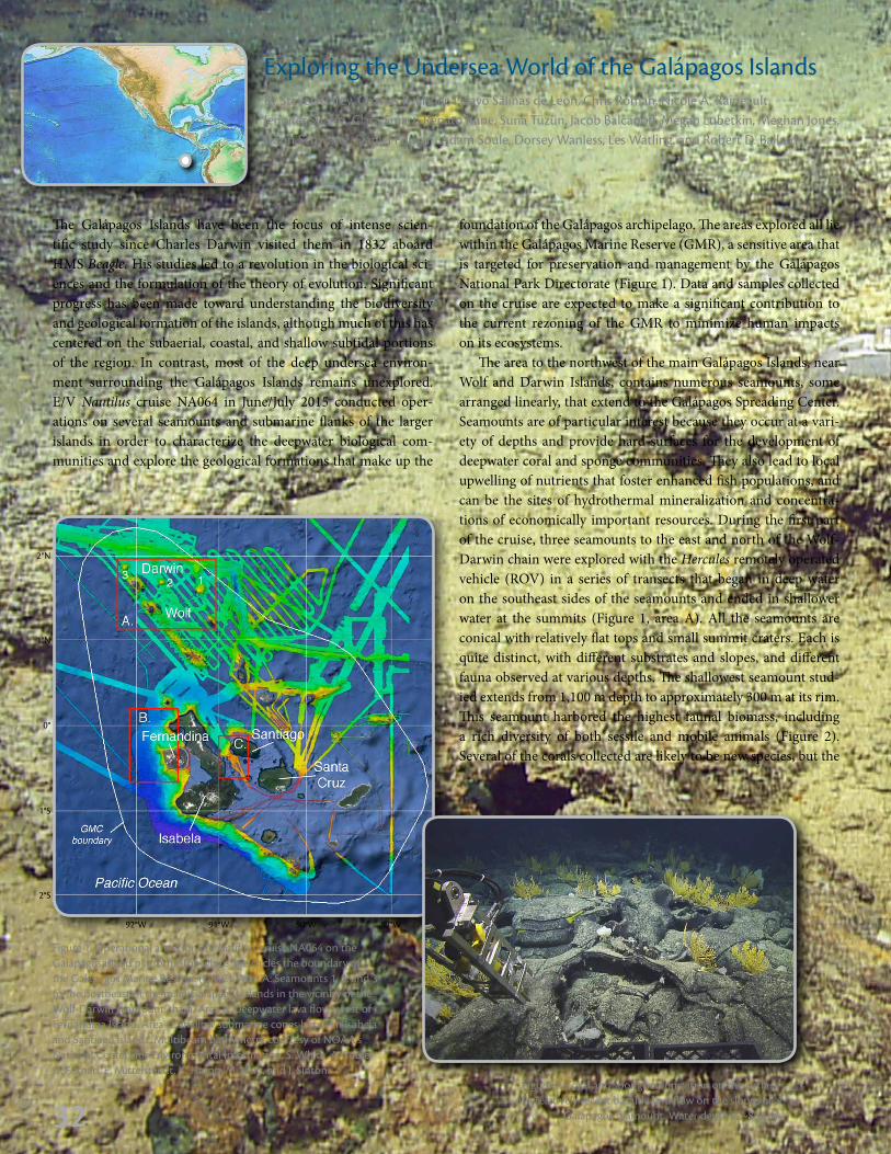
Exploring the Undersea World of the Galápagos Islands By Steven Carey, Charles R. Fisher, Pelayo Salinas de Leon, Chris Roman, Nicole A. Raineault, Jennifer Suarez, Clara Smart, Renato Kane, Suna Tüzün, Jacob Balcanoff, Megan Lubetkin, Meghan Jones, Darin Schwartz, Daniel Fornari, Adam Soule, Dorsey Wanless, Les Watling, and Robert D. Ballard
The Galápagos Islands have been the focus of intense scien-tific study since Charles Darwin visited them in 1832 aboard HMS Beagle. His studies led to a revolution in the biological sci-ences and the formulation of the theory of evolution. Significant progress has been made toward understanding the biodiversity and geological formation of the islands, although much of this has centered on the subaerial, coastal, and shallow subtidal portions of the region. In contrast, most of the deep undersea environ-ment surrounding the Galápagos Islands remains unexplored. E/V Nautilus cruise NA064 in June/July 2015 conducted oper-ations on several seamounts and submarine flanks of the larger islands in order to characterize the deepwater biological com-munities and explore the geological formations that make up the
Figure 2. Coral and sponge colonization on the surface of a relatively recent basaltic lava flow on the slopes of a
Galápagos seamount. Water depth is ~850 m.
Figure 1. Operational areas for E/V Nautilus cruise NA064 on the Galápagos island platform. The white line circles the boundary of the Galápagos Marine Reserve (GMC). Area A: Seamounts 1, 2, and 3 to the northeast of the main Galápagos islands in the vicinity of the Wolf-Darwin seamount chain. Area B: Deepwater lava flows west of Fernandina Island. Area C: Shallow submarine cones between Isabela and Santiago Islands. Multibeam bathymetry courtesy of NOAA's National Centers for Environmental Information, S. White, A. Soule, D. Fornari, E. Mittelstaedt, K. Harpp, M. Kurz, and J. Sinton.
foundation of the Galápagos archipelago. The areas explored all lie within the Galápagos Marine Reserve (GMR), a sensitive area that is targeted for preservation and management by the Galápagos National Park Directorate (Figure 1). Data and samples collected on the cruise are expected to make a significant contribution to the current re zoning of the GMR to minimize human impacts on its ecosystems.
The area to the northwest of the main Galápagos Islands, near Wolf and Darwin Islands, contains numerous seamounts, some arranged linearly, that extend to the Galápagos Spreading Center. Seamounts are of particular interest because they occur at a vari-ety of depths and provide hard surfaces for the development of deepwater coral and sponge communities. They also lead to local upwelling of nutrients that foster enhanced fish populations, and can be the sites of hydrothermal mineralization and concentra-tions of economically important resources. During the first part of the cruise, three seamounts to the east and north of the Wolf-Darwin chain were explored with the Hercules remotely operated vehicle (ROV) in a series of transects that began in deep water on the southeast sides of the seamounts and ended in shallower water at the summits (Figure 1, area A). All the seamounts are conical with relatively flat tops and small summit craters. Each is quite distinct, with different substrates and slopes, and different fauna observed at various depths. The shallowest seamount stud-ied extends from 1,100 m depth to approximately 300 m at its rim. This seamount harbored the highest faunal biomass, including a rich diversity of both sessile and mobile animals (Figure 2). Several of the corals collected are likely to be new species, but the
2°N
0°
1°N
1°S
2°S
92°W 90°W91°W 89°W
32

33
tens of centimeters in diameter and quite friable, consisting of a several centimeter thick, harder crust and a more porous inte-rior. In areas where the tubes were cracked, the openings were colonized by mats of bright yellow bacteria. Inside the tubes, a bright green mineral was present as a soft aggregate (Figure 4). This mineral is likely to be nontronite, an iron-rich clay that forms from hydrothermal alteration of volcanic rocks at temperatures of about ~50°C. One of the tubes was occupied by a large soli-tary hydrocoral, a species that has never been reported in this region (Figure 5). The presence of bacteria around the tubes and the occurrence of nontronite indicate that there is an active low temperature hydrothermal system at the summit of this seamount likely driven by shallow-level magma.
On the west side of Fernandina Island, the ROV explored a series of large underwater lava flows in depths to 3,000 m (Figure 1, Area B). Several are up to 15 km long and are some of the largest submarine lava flows known. They had previously been mapped using surface-towed side-scan sonar but had never been visually observed. The objectives of the dives on these deepwater flows were to define individual flow units, collect lava samples for geochemical analyses, and make morphological observations in order to interpret flow formation processes. The Galápagos Islands are volcanic in origin and sit atop an elevated submarine platform whose formation is related to a hotspot that, in addition to building the archipelago, supplies magma to the nearby Galápagos Spreading Center. Little is known about the voluminous submarine eruptions that are associated with hotspot
highlights were arguably some of the non-coral fauna. Very early in the dive, we collected a pancake batfish that has never before been documented in the region and that may prove to be new to science (Figure 3). In the middle of this dive, what appeared from a distance to be a branching coral was suspected to be a glass sponge upon closer examination. Shore-based scientists agree this is a completely unknown species, with perhaps a new type of sponge growth morphology. The dive was topped off at the summit when Hercules encountered hammerhead sharks. These sightings confirmed data from acoustically tagged individuals that suggest sharks might visit these seamounts from their well-known habitats off the shores of Darwin and Wolf Islands to the west.
The other two seamounts were in deeper water, with their bases at about 2,000 m depth and summits just near 1,000 m. Both had generally lower density and diversity of megafauna than the shal-lower seamount and were more heavily sedimented than expected from the relatively steep slopes apparent in the multibeam bathymetry data acquired before each dive. Glass sponges were abundant on exposed outcrops as well as occasional octocorals, black corals, and hard corals.
None of the seamounts showed evidence of recent volcanism in the form of glassy lava flows devoid of a sediment coating. Pillow lava outcrops were common on all the slopes but were nor-mally lightly coated with sediment that accumulates with age. At the summit of the third seamount, just north of Darwin Island (Figure 1, area A), we discovered an unusual sinuous network of tube-like deposits covering the seafloor. The tubes were several
Figure 3. Pancake batfish on the slope of Galápagos seamount 1. Water depth is 1,181 m.
Figure 4. Hydrothermal tube deposits near the summit of Galápagos seamount 3 (see Figure 1 for location). Broken crust
at lower left-hand side reveals bright green nontronite and reddish-orange iron oxide precipitates. Water depth is 1,228 m.
Figure 5. Giant solitary octocoral colonizing a hydrothermal tube
deposit near the summit of Galápagos Seamount 2. No giant
solitary octocorals have previously been known from this region.
33

34
hard corals (Figure 9). To the southwest, a second cone exhibited lower biodiversity and abundance of fauna along a transect up its east side. The base of this cone was heavily sedimented with only occasional outcrops of pillow lava. The peak was very narrow and contained a linear ridge of structures up to 2 m high that resem-bled a picket fence heavily covered with corals, sponges, and asso-ciates. The dive ended with collection of the largest volcanic rock ever retrieved by Hercules, a ~45 kg single pillow basalt sample.
With new discoveries on every seamount, submarine volcanic cone, and lava flow visited, it is clear that we have only scratched the surface of the amazing subsea world of the Galápagos Island chain. When our geological collaborators ashore complete their studies of the 41 lava samples collected, we will better understand the genesis and ongoing formation of these iconic islands. In addi-tion, the biological collections currently being examined by spe-cialists all over the world will not only significantly increase our appreciation of the diversity of the deep-sea fauna of this region, but also result in description of many species never before seen and add to our understanding of the diversity of life in the ocean.
volcanism, and these flows west of Fernandina provide a unique window into these processes. A single flow was targeted for an ROV transect from ~3,300 m depth to shallower water up the west side of Fernandina. Despite some covering with sediment, the margins of the flow could be identified and sampled. At the distal end in water depths of ~3,000 m, the flows consisted largely of pillow lava outcrops (Figure 6). Further upslope, the flow charac-ter changed to areas of spectacular sheet flow outcrops, indicating higher magma discharge rates (Figure 7). There were numerous examples of collapse pits where magma drained away below a quenched crust. The draining produced still-stand levels of glassy lava crust apparent in the sides of the collapse pits (Figure 8). One particularly large, circular collapse pit was ~60 m in diameter and 20–30 m deep. Hercules descended into the pit to examine the walls and floor of the structure.
The final dive focused on two shallow-water volcanic cones between Santiago and Isabela Islands (Figure 1, Area C), which lie in a transitional area between large, highly active shield volca-noes with calderas to the west on Fernandina and Isabela Islands, and less active, caldera-lacking volcanoes to the east on Santiago, Santa Cruz, and Floreana Islands. Both cones have horse-shoe-shaped craters with central domes, suggesting that minor slope failures have occurred in the past. The dive was designed primarily to sample lavas for analyses that will lead to a better understanding of the genesis of the surrounding islands and to document the biodiversity on the cones. A transect up the first cone began at about 600 m depth and ascended toward the crater. Most of the volcanic outcrops were covered by carbonate crust, but it was possible to collect samples of small lava tubes and pillow shells. A trough in the crater area was covered with well-sorted black volcaniclastic sand, which suggests that there may have been explosive submarine activity on these cones at one time. Pillow lavas along a ridge that extended from the crater to the southeast were spectacularly colonized by octocorals, black corals, and
Figure 6. Pillow lavas with minor sedi-ment accumulation on the west side of Fernandina. Water depth is 2,986 m.
Figure 7. Sample collection of basal-tic sheet flow off the west coast of
Fernandina. Water depth is 2,922 m.
Figure 9. Corals and sponges colonizing an outcrop on a shallow volcanic cone between the islands of
Isabela and Santiago. Water depth is 465 m.
Figure 8. Collapse pit on the surface of a lobate lava flow off the west
coast of Fernandina. Lava drainage levels are exposed in the wall of the
collapse pit. Water depth is 2,947 m.
34