ROUTE 9/WESTERN MONMOUTH - visitmonmouth.com24\Western Monmouth Development... · • Englishtown...
68
ROUTE 9/WESTERN MONMOUTH DEVELOPMENT PLAN CORRIDOR PROFILE AND PROBLEM IDENTIFICATION MARCH 2002 PREPARED BY: IN ASSOCIATION WITH:
Transcript of ROUTE 9/WESTERN MONMOUTH - visitmonmouth.com24\Western Monmouth Development... · • Englishtown...
ROUTE 9/WESTERN MONMOUTH
DEVELOPMENT PLAN
CORRIDOR PROFILE AND PROBLEM IDENTIFICATION
MARCH 2002
PREPARED BY:
IN ASSOCIATION WITH:

i
TABLE OF CONTENTS
INTRODUCTION....................................................................................................................................... 1
STUDY AREA............................................................................................................................................. 2
DEMOGRAPHIC CONDITIONS............................................................................................................. 4 POPULATION.............................................................................................................................................. 4 JOBS........................................................................................................................................................... 6
LAND USE .................................................................................................................................................. 8 CURRENT CONDITIONS.............................................................................................................................. 8 DEVELOPABLE LANDS ............................................................................................................................ 11 PLANNED DEVELOPMENT ACTIVITY....................................................................................................... 13
ENVIRONMENTAL CONDITIONS ..................................................................................................... 15 WETLANDS.............................................................................................................................................. 15 FARMLAND AND OPEN SPACE................................................................................................................. 15
COMMUNITY INFRASTRUCTURE.................................................................................................... 21 SEWER ..................................................................................................................................................... 21 WATER .................................................................................................................................................... 21 EDUCATIONAL FACILITIES ...................................................................................................................... 23
TRANSPORTATION............................................................................................................................... 24 COMMUTATION PATTERNS ..................................................................................................................... 24 BUS.......................................................................................................................................................... 24 RAIL ........................................................................................................................................................ 27 PARK AND RIDE....................................................................................................................................... 27 PEDESTRIAN ............................................................................................................................................ 29
Pedestrian Priorities ............................................................................................................................ 29 Pedestrian Conditions ......................................................................................................................... 29
EXISTING TRAFFIC CONDITIONS ............................................................................................................. 32 Current Roadway Features.................................................................................................................. 32 Current Traffic Volumes..................................................................................................................... 33 Current Traffic Conditions.................................................................................................................. 35
FUTURE TRAFFIC CONDITIONS ............................................................................................................... 38 Planned Roadway Improvements........................................................................................................ 38 Future Traffic Volumes....................................................................................................................... 39
PLANNING ............................................................................................................................................... 43 STATE DEVELOPMENT AND REDEVELOPMENT PLAN ............................................................................. 43
State Planning Areas ........................................................................................................................... 43 Center Designation Process ................................................................................................................ 43 Western Monmouth Region State Planning Areas.............................................................................. 44
MUNICIPAL PLANS .................................................................................................................................. 46 Englishtown ........................................................................................................................................ 46 Farmingdale ........................................................................................................................................ 47 Freehold Borough ............................................................................................................................... 47 Freehold Township ............................................................................................................................. 48 Howell................................................................................................................................................. 48

ii
Manalapan........................................................................................................................................... 49 Marlboro ............................................................................................................................................. 50
DESIGN ..................................................................................................................................................... 52 DESCRIPTION OF EXISTING ENVIRONMENT ............................................................................................ 52 DESIGN ASSESSMENT.............................................................................................................................. 55
Transportation Corridors..................................................................................................................... 56 Development Regulations ................................................................................................................... 57 Development Patterns ......................................................................................................................... 58
ISSUES....................................................................................................................................................... 59 PLANNING ............................................................................................................................................... 59
Land Use ............................................................................................................................................. 59 Farmland Preservation ........................................................................................................................ 59 State Plan ............................................................................................................................................ 60 Planning Issues.................................................................................................................................... 60
COMMUNITY INFRASTRUCTURE.............................................................................................................. 60 Community Infrastructure Issues ........................................................................................................ 60
TRANSPORTATION................................................................................................................................... 61 Transportation Issues .......................................................................................................................... 61
DESIGN .................................................................................................................................................... 62 Design Issues ...................................................................................................................................... 62
iii
LIST OF MAPS AND FIGURE Map 1 – Study Area ...................................................................................................................................... 3 Map 2 – Developed Land.............................................................................................................................. 9 Map 3 – Developable Lands ....................................................................................................................... 12 Map 4 – Planned Development................................................................................................................... 14 Map 5 – Wetlands ....................................................................................................................................... 16 Map 6 – Farmlands ..................................................................................................................................... 18 Map 7 – Sewer Service ............................................................................................................................... 22 Map 8 – Transportation Systems ................................................................................................................ 26 Map 9 - Current Traffic Volumes ............................................................................................................... 34 Map 10 – Evening Peak Hour Levels of Service ........................................................................................ 36 Figure 1 – Traffic Volume Comparison...................................................................................................... 40 Map 11 – 2020 Levels of Service ............................................................................................................... 41 Map 12 – 2020 Levels of Service with Improvements ............................................................................... 42 Map 13 – State Plan Policy Map................................................................................................................. 45 Map 14 – Design Assessment ..................................................................................................................... 55

iv
LIST OF TABLES Table 3: Dwelling Units per Square Mile, 2000-2020................................................................................. 4 Table 1: Historic and Projected Population, 1980-2020 .............................................................................. 5 Table 2: Historic and Projected Households, 1990-2020............................................................................. 5 Table 4: At Place Employment, 1995-2020................................................................................................. 6 Table 5: Jobs to Dwelling Unit Ratio, 2000-2020 ....................................................................................... 7 Table 6: Median Household Income, 1989 and 2000 .................................................................................. 7 Table 7: Developable Land Status, Year 2000 .......................................................................................... 11 Table 8: Planned Housing Units, 2000-2020 ............................................................................................. 13 Table 9: Planned Employment, 2000-2020................................................................................................ 13 Table 10: Final (10-Year) Farmland Preservation Goals ........................................................................... 15 Table 11: DEP Agricultural Lands, 1997................................................................................................... 17 Table 12: Potential Park, Recreation and Open Space Acquisitions ......................................................... 17 Table 13: Farmland and Open Space Preservation Taxes.......................................................................... 19 Table 14: Journey to Work by Destination, 1990 ...................................................................................... 25 Table 15: Mode of Journey to Work, 1990................................................................................................ 25 Table 16: Bus Ridership............................................................................................................................. 27 Table 17: Park and Ride Lots..................................................................................................................... 28 Table 18: Intersection/ Interchange Listing ............................................................................................... 32 Table 19: Level of Service and Expected Delay for Signalized Intersections ........................................... 35 Table 20: Municipal Planning Initiatives................................................................................................... 46
1
INTRODUCTION The Western Monmouth Development Plan is a study funded by the Smart Growth Program of the New Jersey Department of Community Affairs, with oversight provided by the Monmouth County Planning Department. The Plan focuses on seven municipalities in Western Monmouth County, which are tied together by their common dependence on U.S. Route 9 as the major north-south arterial. These municipalities have collectively experienced explosive population and employment growth over the past two decades. The Western Monmouth Plan is partly intended to build upon the County Growth Management Plan, which was adopted in 1995. The plan establishes growth management policies in 10 different areas. One policy area is “Centers”: the goal of this policy area is to “promote new and revitalize older urban areas into well designed mixed use centers with an easily accessible compact but varied core of residential, commercial and community services which provide employment and create a specific identity.” This study is intended to produce a “smart growth” plan for the study area; one that will encourage the formation of more livable communities and better preserve the natural resources currently being consumed by suburban sprawl. The plan will address short term issues through proposing strategies that municipalities can incorporate into their land use and design regulations, and is also intended to provide a longer term vision for the communities. Finally, this plan is intended to result in an Endorsed Plan for the Route 9/Western Monmouth region which will give the region priority in receiving state funding for future infrastructure improvements. The plan is also intended to provide a greater identity to Route 9 in this area, which lacks a distinct character. This report presents “baseline conditions” in the study area: land use, demographics, environmental resources, infrastructure, transportation, consistency of municipal plans with the State Plan, and design. Through an analysis of these conditions, the important issues in each study area community can be identified. In subsequent stages of the study, planning solutions will be identified for reconciling municipal goals with smart growth program goals. Following are the overall goal and objectives for the Western Monmouth Development Plan: Goal - To create a vision and a policy framework for Route 9/Western Monmouth Corridor Region that will promote sustainable development and transportation mobility, and manage growth. Objectives
• To identify and assess current and future land use and transportation conditions of the Route 9 Corridor Region.
• To identify development and redevelopment concepts that will help municipalities manage growth in keeping with available infrastructure.
• To maintain or improve mobility by enhancing the existing transportation network and by encouraging the development of alternative transportation modes, including biking, walking and transit.
• To protect natural resources in balance with the built environment. • To preserve farmland. • To promote growth in Centers and other compact forms, and counteract sprawl. • To protect the character and quality of life of the region. • To cooperatively prepare a regional plan for submittal to the State Planning Commission for Plan
Endorsement.

2
STUDY AREA Monmouth County is located in east-central New Jersey. With a land area of 472 square miles, the County ranks as the state’s sixth largest. Its population in 2000 was 615,301, placing it fourth among New Jersey counties. With its relatively level topography, and with its only significant physical constraint the large areas covered by wetlands, the County was poised for rapid growth once the New York-Northern New Jersey “growth belt” expanded beyond Middlesex County. The Western Monmouth region (Map 1) consists of seven municipalities encompassing about 105,510 acres, or 165 square miles. These municipalities are:
• Englishtown Borough • Farmingdale Borough • Freehold Borough • Freehold Township • Howell Township • Manalapan Township • Marlboro Township
The three boroughs are completely encompassed by three of the townships: Englishtown by Manalapan, Farmingdale by Howell, and Freehold Borough by Freehold Township. Freehold Borough is the county seat, and is located close to the heart of the Western Monmouth region. In contrast to Freehold Borough, the two boroughs of Englishtown and Farmingdale account for a minimal number of both housing units and jobs, and are relatively minor attractions for residents in the surrounding townships. These seven communities in the Western Monmouth region are tied together by the presence of Route 9. This four-lane highway runs through five of the seven municipalities, and the two communities not on the highway – Englishtown Borough and Farmingdale Borough – incorporate the roadway into a large percentage of their trips.

3
Map 1 – Study Area
4
DEMOGRAPHIC CONDITIONS
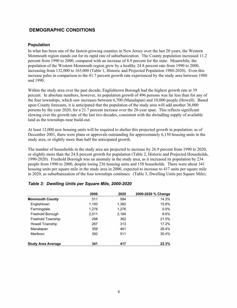
Population In what has been one of the fastest-growing counties in New Jersey over the last 20 years, the Western Monmouth region stands out for its rapid rate of suburbanization. The County population increased 11.2 percent from 1990 to 2000, compared with an increase of 8.9 percent for the state. Meanwhile, the population of the Western Monmouth region grew by a healthy 24.8 percent rate from 1990 to 2000, increasing from 132,000 to 165,000 (Table 1, Historic and Projected Population 1980-2020). Even this increase pales in comparison to the 41.7 percent growth rate experienced by the study area between 1980 and 1990. Within the study area over the past decade, Englishtown Borough had the highest growth rate at 39 percent. In absolute numbers, however, its population growth of 496 persons was far less than for any of the four townships, which saw increases between 6,700 (Manalapan) and 10,000 people (Howell). Based upon County forecasts, it is anticipated that the population of the study area will add another 36,000 persons by the year 2020, for a 21.7 percent increase over the 20-year span. This reflects significant slowing over the growth rate of the last two decades, consistent with the dwindling supply of available land as the townships near build-out. At least 12,000 new housing units will be required to shelter this projected growth in population; as of December 2001, there were plans or approvals outstanding for approximately 6,150 housing units in the study area, or slightly more than half the anticipated growth. The number of households in the study area are projected to increase by 26.9 percent from 1990 to 2020, or slightly more than the 24.8 percent growth for population (Table 2, Historic and Projected Households, 1990-2020). Freehold Borough was an anomaly in the study area, as it increased its population by 234 people from 1990 to 2000, despite losing 236 housing units and 158 households. There were about 341 housing units per square mile in the study area in 2000, expected to increase to 417 units per square mile in 2020, as suburbanization of the four townships continues. (Table 3, Dwelling Units per Square Mile). Table 3: Dwelling Units per Square Mile, 2000-2020 2000 2020 2000-2020 % Change Monmouth County 511 584 14.3% Englishtown 1,193 1,382 15.8% Farmingdale 1,276 1,276 0.0% Freehold Borough 2,011 2,184 8.6% Freehold Township 298 362 21.5% Howell Township 267 313 17.2% Manalapan 359 461 28.4% Marlboro 392 511 30.4% Study Area Average 341 417 22.3%

5
Table 1: Historic and Projected Population, 1980-2020 Change 1980-1990 Change 1990-2000 Change 2000-2020 1980 1990 Number Percent 2000 Number Percent 2005 2010 2020 Number Percent Monmouth County 503,173 553,124 49,951 9.9% 615,301 62,177 11.2% 654,568 669,484 702,599 87,298 14.2% Englishtown Borough 976 1,268 292 29.9% 1,764 496 39.1% 1,794 1,950 2,043 279 15.8% Farmingdale Borough 1,348 1,462 114 8.5% 1,587 125 8.5% 1,587 1,587 1,587 0 0.0% Freehold Borough 10,020 10,742 722 7.2% 10,976 234 2.2% 11,305 11,414 11,633 657 6.0% Freehold Township 19,202 24,710 5,508 28.7% 31,537 6,827 27.6% 34,944 36,038 38,225 6,688 21.2% Howell Township 25,065 38,987 13,922 55.5% 48,903 9,916 25.4% 54,624 55,534 57,354 8,451 17.3% Manalapan Township 18,914 26,716 7,802 41.2% 33,423 6,707 25.1% 37,000 38,667 42,000 8,577 25.7% Marlboro Township 17,560 27,974 10,414 59.3% 36,398 8,424 30.1% 42,043 43,822 47,380 10,982 30.2% Study Area Total 93,085 131,859 38,774 41.7% 164,588 32,729 24.8% 183,297 189,012 200,222 35,634 21.7% Source: 1980, 1990, 2000- US Census; 2005, 2020 projections - Monmouth County Planning Board. 2010 projections were extrapolated from 2005 and 2020 projections. Table 2: Historic and Projected Households, 1990-2020 Change 1990-2000 Change 2000-2020 1990 2000 Number Percent 2005 2010 2020 Number Percent Monmouth County 197,325 224,236 26,911 13.6% 238,779 244,304 256,569 32,333 14.4% Englishtown Borough 450 643 193 42.9% 654 711 745 102 15.9% Farmingdale Borough 564 625 61 10.8% 625 625 625 0 0.0% Freehold Borough 3,853 3,695 -158 -4.1% 3,901 3,937 4,012 317 8.6% Freehold Township 8,327 10,814 2,487 29.9% 12,027 12,404 13,116 2,302 21.3% Howell Township 12,747 16,063 3,316 26.0% 17,945 18,244 18,843 2,780 17.3% Manalapan Township 8,478 10,781 2,303 27.2% 12,080 12,760 13,838 3,057 28.4% Marlboro Township 8,204 11,478 3,274 39.9% 13,270 13,835 14,964 3,486 30.4% Study Area Total 42,623 54,099 11,476 26.9% 60,502 62,516 66,143 12,044 22.3% Source: 1990, 2000 housing data - U.S. Census Bureau. 2005, 2010, 2020 estimates were determined through applying 2000 average household size to Monmouth County population projections (excluding institutionalized population in Freehold Township).
6
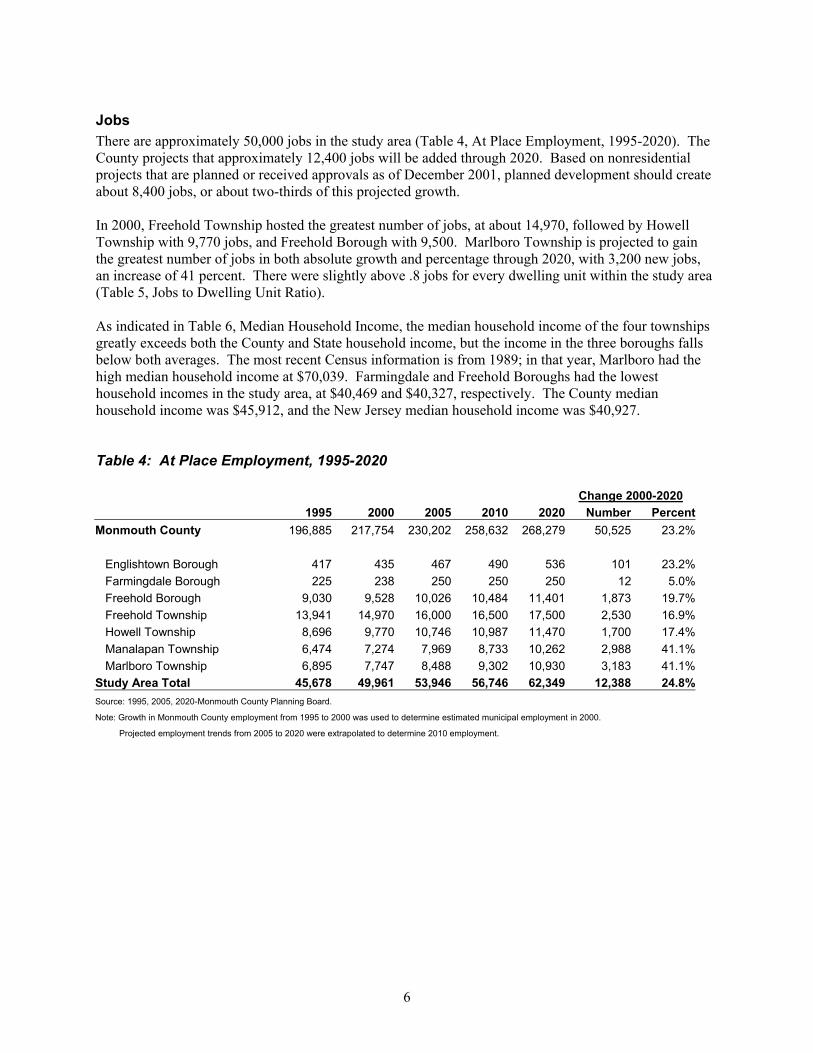
Jobs There are approximately 50,000 jobs in the study area (Table 4, At Place Employment, 1995-2020). The County projects that approximately 12,400 jobs will be added through 2020. Based on nonresidential projects that are planned or received approvals as of December 2001, planned development should create about 8,400 jobs, or about two-thirds of this projected growth. In 2000, Freehold Township hosted the greatest number of jobs, at about 14,970, followed by Howell Township with 9,770 jobs, and Freehold Borough with 9,500. Marlboro Township is projected to gain the greatest number of jobs in both absolute growth and percentage through 2020, with 3,200 new jobs, an increase of 41 percent. There were slightly above .8 jobs for every dwelling unit within the study area (Table 5, Jobs to Dwelling Unit Ratio). As indicated in Table 6, Median Household Income, the median household income of the four townships greatly exceeds both the County and State household income, but the income in the three boroughs falls below both averages. The most recent Census information is from 1989; in that year, Marlboro had the high median household income at $70,039. Farmingdale and Freehold Boroughs had the lowest household incomes in the study area, at $40,469 and $40,327, respectively. The County median household income was $45,912, and the New Jersey median household income was $40,927. Table 4: At Place Employment, 1995-2020 Change 2000-2020 1995 2000 2005 2010 2020 Number Percent Monmouth County 196,885 217,754 230,202 258,632 268,279 50,525 23.2% Englishtown Borough 417 435 467 490 536 101 23.2% Farmingdale Borough 225 238 250 250 250 12 5.0% Freehold Borough 9,030 9,528 10,026 10,484 11,401 1,873 19.7% Freehold Township 13,941 14,970 16,000 16,500 17,500 2,530 16.9% Howell Township 8,696 9,770 10,746 10,987 11,470 1,700 17.4% Manalapan Township 6,474 7,274 7,969 8,733 10,262 2,988 41.1% Marlboro Township 6,895 7,747 8,488 9,302 10,930 3,183 41.1% Study Area Total 45,678 49,961 53,946 56,746 62,349 12,388 24.8% Source: 1995, 2005, 2020-Monmouth County Planning Board. Note: Growth in Monmouth County employment from 1995 to 2000 was used to determine estimated municipal employment in 2000.
Projected employment trends from 2005 to 2020 were extrapolated to determine 2010 employment.

7
Table 5: Jobs to Dwelling Unit Ratio, 2000-2020 2000 2020 2000-2020 % Change Monmouth County .90/1 .97/1 7.8% Englishtown .64/1 .68/1 6.3% Farmingdale .37/1 .39/1 5.4% Freehold Borough 2.49/1 2.75/1 10.4% Freehold Township 1.36/1 1.31/1 -3.7% Howell Township .59/1 .59/1 0.0% Manalapan .66/1 .72/1 9.1% Marlboro .65/1 .70/1 7.7% Study Area .82/1 .92/1 12.1% Table 6: Median Household Income, 1989 and 2000 1989 2000 New Jersey $40,927 N/A Monmouth County $45,912 $73,263 Englishtown Borough $43,472 $71,876 Farmingdale Borough $40,469 $62,086 Freehold Borough $40,327 $61,568 Freehold Township $58,756 $98,631 Howell Township $47,912 $77,619 Manalapan Township $58,028 $97,252 Marlboro Township $70,039 $128,190 Source: 1989- US Census 2000 income estimates- Monmouth County Planning Board

8
LAND USE
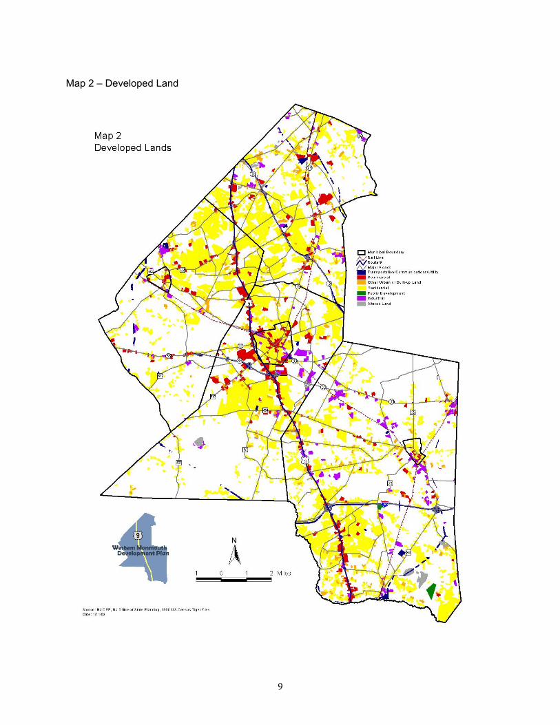
Current Conditions Urban land uses within the Western Monmouth region are indicated on Map 2, Developed Land Map. (This map is based on data gathered by the NJ Department of Environmental Protection in 1995-97. Although updated by Orth-Rodgers & Associates, it understates the amount of urbanized land in the study area.) As is evident, residential uses are the predominant land use within the region. In the four townships, the
large majority of residences are single-family detached, ranging from 66 to 85 percent as of the 1990 Census. The boroughs have a smaller percentage of single family detached units, at 47 to 54 percent. Residential areas are diffuse through the study area, although much of the development has spread outwards from the two major roadways in the study area, Route 9 and Route 18. A relatively small percentage of residential units are directly on Route 9; these include several higher density developments, such as Covered Bridge, Towne Pointe, and Marlboro Greens.
Freehold subdivision. Office and retail uses are heavily concentrated along Route 9, however, the character does change to a certain extent along the corridor. Marlboro has less frontage along Route 9 than the other three townships. It has several strip retail centers and smaller office buildings. Manalapan is marked by a greater profusion of strip retail centers, and the most recent addition, the Epicenter, a half-million square feet “power center.” Office and retail uses are segregated along Route 9 in Freehold Township to a greater degree than in the other three townships. North of Freehold Borough, there are a number of large automobile dealers, as well as office buildings. Freehold Raceway Mall, the largest retail center on the corridor, is found directly west of Freehold Borough, and defines the northern boundary of the retail center complex in Freehold Township. The Raceway Mall, together with a number of “big box” stores on service drives to the Mall, account for about 2 million square feet in retail uses. Further south along Route 9 is the Freehold Mall, a somewhat faded strip retail center, which stands as an example of an older retail center along the corridor. South of the Freehold retail complex, the office and automobile oriented uses again predominate, including the Juniper Office Plaza. Gordon’s Lumber, an abandoned business south of Freehold Borough, is one of the potential redevelopment sites along Route 9 in Freehold Township. Strip center along Route 9 in Marlboro.
9
Map 2 – Developed Land
10
A number of large retail centers are scattered along Route 9 in Howell Township. Most of these are located south of I-195, including Kohl’s, Walmart, and several shopping plazas anchored by major supermarkets. Howell offers the greatest potential for commercial development along Route 9 than any other municipality, in terms of roadway frontage, vacant parcels, and marginal uses, including abandoned businesses, storage facilities, and small retail establishments. The commercial potential of the corridor in Howell will be further augmented when the Township follows through with its plan to install public sewer along the corridor. Although Route 9 is immediately west of Freehold Borough, there are no retail or office buildings in this section of the borough, only medium to high density residential uses. Freehold Borough has an attractive downtown, featuring county offices along with a mix of office and retail uses. Englishtown and Farmingdale Boroughs both have small downtowns within walking distance of much of their housing stock. Certain large parcels within the corridor are public lands and will not be developed. These areas include the Monmouth Battlefield Park, immediately west of Route 9, in both Freehold and Manalapan Townships; the Turkey Swamp State Park, covering much of southern Freehold Township between CR 524 and the Freehold border; the Manasquan Reservoir in central Howell Township; and Allaire State Park along Howell’s eastern border. The Earle Naval Weapons Base, covering approximately six square
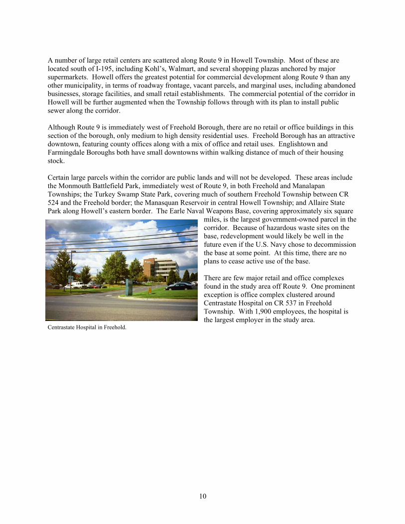
miles, is the largest government-owned parcel in the corridor. Because of hazardous waste sites on the base, redevelopment would likely be well in the future even if the U.S. Navy chose to decommission the base at some point. At this time, there are no plans to cease active use of the base. There are few major retail and office complexes found in the study area off Route 9. One prominent exception is office complex clustered around Centrastate Hospital on CR 537 in Freehold Township. With 1,900 employees, the hospital is the largest employer in the study area.
Centrastate Hospital in Freehold.

11
Developable Lands As of 2000, there were approximately 26,000 acres of developable lands within the study area municipalities, as shown in Table 7. (Map 3, Developable Lands, shows the location of all developable lands in the study area. These are lands that are vacant or in agricultural use, less wetlands and, where known, development protections such as government ownership or easements.) Table 7: Developable Land Status, Year 2000 Non-Residential Residential Total Developable Percentage of Acreage Acreage Acreage Total Land Englishtown Borough 4 44 48 13% Farmingdale Borough 1 15 16 5% Freehold Borough 11 24 35 3% Freehold Township 1,378 4,929 6,307 26% Howell Township 1,360 7,494 8,854 22% Manalapan Township 979 4,000 4,979 25% Marlboro Township 602 4,887 5,489 28% Study Area Total 4,335 21,393 25,728 24% Within the four townships, acreage of developable land varied from about 5,000 in Manalapan to 9,000 in Howell. These estimates are likely to differ from developable land estimates produced by each municipality, as municipal estimates are typically derived from tax assessment records. The estimates in this Plan, on the other hand, are based upon DEP calculations, which are derived from an analysis of aerial photographs. It should further be noted that the estimates of developable lands in the three boroughs in the study area are much less meaningful than estimates for the townships. Much of the housing units and employment created in the boroughs in the future will be redevelopment projects, and will thus not consume developable lands, or “greenfields.”
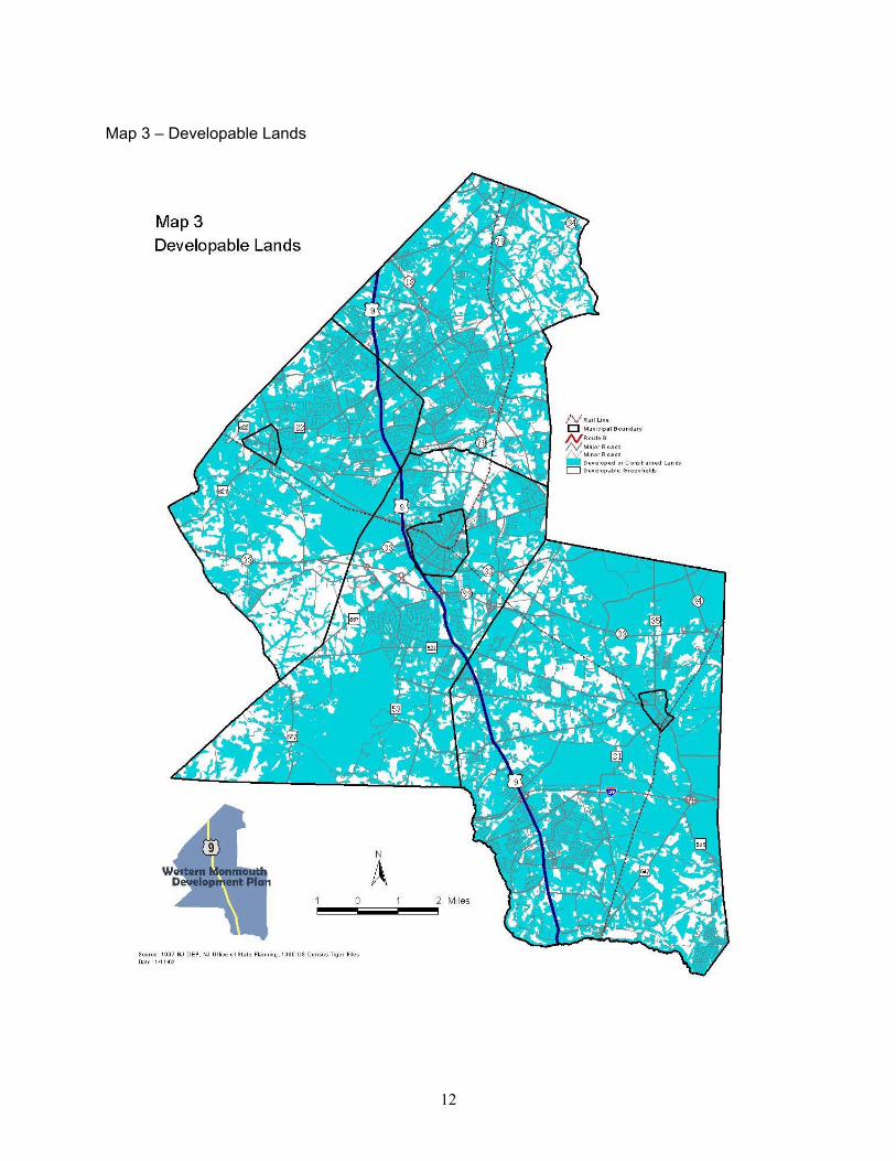
12
Map 3 – Developable Lands
13
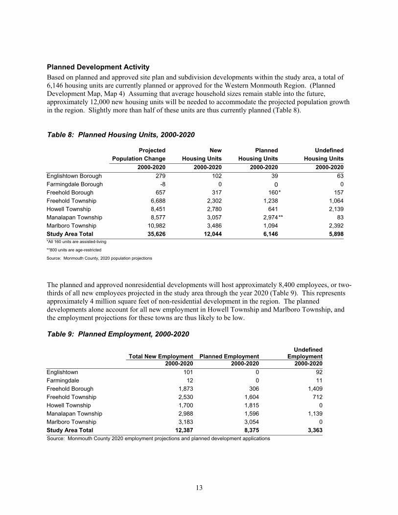
Planned Development Activity Based on planned and approved site plan and subdivision developments within the study area, a total of 6,146 housing units are currently planned or approved for the Western Monmouth Region. (Planned Development Map, Map 4) Assuming that average household sizes remain stable into the future, approximately 12,000 new housing units will be needed to accommodate the projected population growth in the region. Slightly more than half of these units are thus currently planned (Table 8). Table 8: Planned Housing Units, 2000-2020 Projected New Planned Undefined
Population Change Housing Units Housing Units Housing Units 2000-2020 2000-2020 2000-2020 2000-2020 Englishtown Borough 279 102 39 63 Farmingdale Borough -8 0 0 0 Freehold Borough 657 317 160 * 157 Freehold Township 6,688 2,302 1,238 1,064 Howell Township 8,451 2,780 641 2,139 Manalapan Township 8,577 3,057 2,974 ** 83 Marlboro Township 10,982 3,486 1,094 2,392 Study Area Total 35,626 12,044 6,146 5,898 *All 160 units are assisted-living **800 units are age-restricted Source: Monmouth County, 2020 population projections The planned and approved nonresidential developments will host approximately 8,400 employees, or two-thirds of all new employees projected in the study area through the year 2020 (Table 9). This represents approximately 4 million square feet of non-residential development in the region. The planned developments alone account for all new employment in Howell Township and Marlboro Township, and the employment projections for these towns are thus likely to be low. Table 9: Planned Employment, 2000-2020
Total New Employment Planned Employment Undefined
Employment 2000-2020 2000-2020 2000-2020
Englishtown 101 0 92 Farmingdale 12 0 11 Freehold Borough 1,873 306 1,409 Freehold Township 2,530 1,604 712 Howell Township 1,700 1,815 0 Manalapan Township 2,988 1,596 1,139 Marlboro Township 3,183 3,054 0 Study Area Total 12,387 8,375 3,363 Source: Monmouth County 2020 employment projections and planned development applications

14
Map 4 – Planned Development

15
ENVIRONMENTAL CONDITIONS
Wetlands In terms of natural conditions, wetlands pose the most significant constraint to development in the study area. Wetlands cover 54 square miles, or one-third of the study area (Map 5, Wetlands). Large concentrations of wetlands are found south of Englishtown Borough in Manalapan, Turkey Swamp Park in Freehold Township, and throughout eastern Howell Township, including Earle Naval Weapons Base and Allaire State Park.
Farmland and Open Space The study area municipalities contain vast swathes of prime farmland. Within Monmouth County, municipalities with the most farmland exhibited the greatest population growth over the last three
decades, a trend which was largely shaped by the four townships in the study area. This conversion of farmland into new housing developments is a concern inasmuch as farmland is one of the most significant natural resources in the Western Monmouth Region. It offers attractive viewscapes, wildlife habitat, and groundwater recharge. Further, unlike many developed land uses, farmland has positive tax benefits. The amount of preserved farmland in the
study area is currently quite small: only 174 acres, with 126 of these in Howell and 48 in Manalapan. An additional 207 acres in Manalapan are under contract to be preserved. In its Farmland Preservation Plan from September 2000, the Monmouth County Planning Board established the following goals for farmland preservation for the study area municipalities: Table 10: Final (10-Year) Farmland Preservation Goals Municipality Current Agricultural Acres Preservation Goal
Acres Freehold Twp 6,134 1,840 Howell 7,357 5,520 Manalapan 7,151 5,360 Marlboro 3,363 1,010 Total 24,005 13,730 Source: Monmouth County Farmland Preservation Plan, September 2000 It should be noted that the estimate of current agricultural acres within study area communities is based upon the amount of farmland-assessed acreage in the study area municipalities. This estimate is higher than the number of agricultural acres as derived from NJ DEP estimates. As of 1997, that estimate indicated the following acreage in agricultural use for the four townships:

16
Map 5 – Wetlands

17
Table 11: DEP Agricultural Lands, 1997 Municipality Agricultural Land Freehold Twp 4,901 Howell 4,310 Manalapan 4,485 Marlboro 2,994 Total 16,690 Source: NJ DEP, 1995-1997
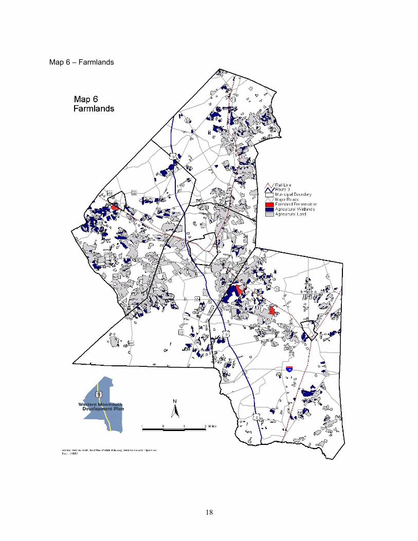
Based upon NJ DEP estimates, it would appear that the Monmouth County farmland preservation goal exceeds available farmland within Howell and Manalapan Townships. However, it should be noted that the agricultural land in the table above does not include agricultural wetlands or harvested forestlands, and that agricultural lands would thus be understated. Farmlands as identified by NJ DEP are shown in Map 6. Protected natural areas cover significant portions of the study area. The largest natural areas are:
• Turkey Swamp – 2,871 acres • Monmouth Battlefield Park – 1,836 acres • Allaire State Park – 1,635 acres • Manasquan Reservoir – 1,261 acres
The Monmouth County 1998 Park, Recreation and Open Space Plan calls for the County to “continue and accelerate its program of open space acquisition for recreation and resource protection.” Following are parcels identified within the study area:
Monmouth Battlefield State Park Table 12: Potential Park, Recreation and Open Space Acquisitions Municipality Parcel Size (acres) Lead Agency
Baysholm Tract 40 County Turkey Swamp 140 County Turkey Swamp 1700 State or County
Freehold Twp
Route 33 site 140 County
Howell Park Golf Course 11 County Manasquan Reservoir 310 County
Howell
Route 524 site 235 County Marlboro Burnt Fly Bog 750 State Source: Amendment to the Monmouth County Park, Recreation and Open Space Plan, March 1998.
18
Map 6 – Farmlands
19
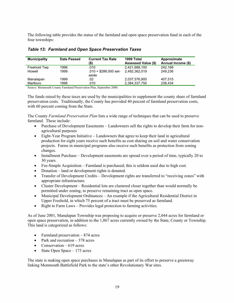
The following table provides the status of the farmland and open space preservation fund in each of the four townships: Table 13: Farmland and Open Space Preservation Taxes Municipality Date Passed Current Tax Rate
($) 1999 Total Assessed Value ($)
Approximate Annual Income ($)
Freehold Twp 1996 .010 2,421,688,100 242,168 Howell 1999 .010 + $286,000 set-
aside 2,492,362,019 249,236
Manalapan 1999 .02 2,037,576,900 407,515 Marlboro 1996 .010 2,384,337,750 238,434 Source: Monmouth County Farmland Preservation Plan, September 2000. The funds raised by these taxes are used by the municipalities to supplement the county share of farmland preservation costs. Traditionally, the County has provided 40 percent of farmland preservation costs, with 60 percent coming from the State. The County Farmland Preservation Plan lists a wide range of techniques that can be used to preserve farmland. These include:
• Purchase of Development Easements – Landowners sell the rights to develop their farm for non-agricultural purposes
• Eight-Year Program Initiative – Landowners that agree to keep their land in agricultural production for eight years receive such benefits as cost sharing on soil and water conservation projects. Farms in municipal programs also receive such benefits as protection from zoning changes.
• Installment Purchase – Development easements are spread over a period of time, typically 20 to 30 years.
• Fee-Simple Acquisition – Farmland is purchased; this is seldom used due to high cost. • Donation – land or development rights is donated. • Transfer of Development Credits – Development rights are transferred to “receiving zones” with
appropriate infrastructure. • Cluster Development – Residential lots are clustered closer together than would normally be
permitted under zoning, to preserve remaining tract as open space. • Municipal Development Ordinances – An example if the Agricultural Residential District in
Upper Freehold, in which 75 percent of a tract must be preserved as farmland. • Right to Farm Laws – Provides legal protection to farming activities.
As of June 2001, Manalapan Township was proposing to acquire or preserve 2,044 acres for farmland or open space preservation, in addition to the 1,867 acres currently owned by the State, County or Township. This land is categorized as follows:
• Farmland preservation – 874 acres • Park and recreation – 378 acres • Conservation – 619 acres • State Open Space – 173 acres
The state is making open space purchases in Manalapan as part of its effort to preserve a greenway linking Monmouth Battlefield Park to the state’s other Revolutionary War sites.

20
Freehold Township passed an Open Space and Recreation Plan in October, 1997. That plan does not establish specific acreage goals for open space preservation, but identifies 108 different parcels that will be considered for future acquisition or preservation. Marlboro passed its most recent Open Space and Recreation Plan in August 2001. The Plan recommends purchasing at least 26 acres by the year 2010 to meet National Recreation and Park Association standards. The Plan identifies 4,921 acres as potential acquisition, including over 2,700 acres of farmland and 2,200 acres of predominantly vacant land. The Plan Map shows parcels totaling 1,550 acres as proposed additions to the Township’s Recreation and Open Space inventory. The Monmouth County Scenic Roadway Plan identifies scenic roadways and lists policies intended to preserve aesthetic features. All municipalities are encouraged to consider these policies in the site design and development review process. Within the study area, scenic roadways are concentrated in western Manalapan, eastern Marlboro and southeastern Howell.

21
COMMUNITY INFRASTRUCTURE
Sewer Sewer service in the study area is concentrated along the Route 9 corridor (Map 7, Sewer Service). The Western Monmouth Utility Authority (WMUA), serving the northern half of the study area, collects wastewater for Englishtown Borough, and portions of Freehold Township, Manalapan Township, and Marlboro Township. Wastewater from the WMUA is treated at the Pine Brook Treatment Plant in Manalapan. The Manasquan River Regional Sewerage Authority (MRRSA) collects wastewater for Farmingdale Borough, Freehold Borough, Howell Township, and portions of Freehold Township. Once collected, wastewater in the MRRSA service area is pumped south to the Ocean County Utility Authority (OCUA) for treatment at its northern plant. The northern-most section of Marlboro Township is serviced by the Bayshore Regional Sewer Authority (BRSA). ` Englishtown, Farmingdale, and Freehold Boroughs are completely sewered, along with northern sections of Manalapan and Freehold Townships and the southwest portion of Marlboro Township. While some residential areas in Howell adjacent to Route 9 currently receive sewer service through NJ American Water Company, and certain commercial properties on Route 9 have managed to tap into these systems, public sewer service directly along the Route 9 corridor is lacking. Howell is beginning a sewer management study that will first concentrate on Route 9 south of Lanes Mill Road, and then focus on Route 9 to the north. The potential of sewering Route 33 will also be examined. The Township would like to design their sewer plan to prevent large housing developments from taking root within the sewer service area. Freehold Township and Manalapan Township are both working to limit growth and are not planning on extending sewer service within their municipalities. The remainder of the region is classified as a discharge-to-groundwater area, particularly in the south where the majority of state and federal parkland is located and development is limited by state planning areas. Future sewer service demand and capacity is an issue facing both sewer authorities. The WMUA is currently operating at 5 million gallons/day, with its capacity set at 6.6 million gallons/day. Projected demand for the system by the year 2018 is 11.119 million gallons/day, with the plant’s 2018 capacity designed to handle only 8.8 million gallons/day. It is not known how the WMUA intends to expand its system’s capacity to accommodate the demand. OCUA is currently operating at 24.69 million gallons/day with a 32 million gallons/day system capacity. OCUA currently has no plans to expand its facilities.
Water Within the study area, water supply demand and capacity is an issue only in Farmingdale. Current demand in the borough exceeds the state-permitted capacity. Farmingdale’s Master Plan recommends limiting future development until an adequate water supply is available.

22
Map 7 – Sewer Service
23
Educational Facilities The study area is occupied by seven school districts. Englishtown and Manalapan are combined into one district, and all high schools are supervised by the Freehold Regional High School District. While Farmingdale and Freehold Boroughs have room to accommodate growth in school enrollments, school capacity is a concern in all four townships, resulting in the recent and planned construction of new schools and additions throughout the study area. In the Freehold Regional High School District, three schools are currently over capacity and additions are planned or under construction for each of the six schools in the district. In Freehold Township, enrollment exceeds capacity in six of its seven schools. Howell Township has surpassed building capacities in six of its ten schools, with both middle schools overcrowded. The Township recently passed a referendum to add three new schools to the district, including two elementary schools and one middle school. Following recent construction of the Wemrock Brook Elementary School, capacity is less of an issue in Manalapan than the other townships. Three of the seven schools in the Englishtown-Manalapan school district are slightly over capacity. Enrollment to capacity information has not yet been provided by the Marlboro School District.

24
TRANSPORTATION
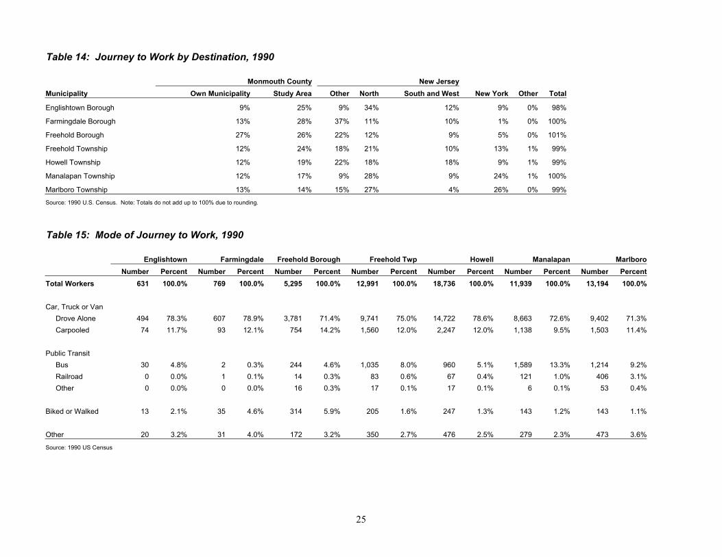
Commutation Patterns Many of the communities in the study area describe themselves as “bedroom communities,” and that description is borne out by the 1990 Journey to Work by Destination data (Table 14). Although about three-quarters of the workers in both Farmingdale and Freehold Boroughs commuted to jobs within the county, no more than about half of the workers in the other municipalities commuted to in-county jobs. Outside Monmouth County, the most common work destination for all seven municipalities was North Jersey, defined here as every county to the north of Monmouth County. The percentage of residents working in North Jersey varied from 11 to 34 percent. New York City finished a close second to North Jersey as a work attraction in Marlboro and Manalapan Townships; about a quarter of the workers from both municipalities held jobs in New York. In other study area communities, the percentage of workers traveling to New York ranged from 1 to 13 percent. The ranking of municipalities by percentage of workers traveling to New York is strongly correlated with the percentage of workers using the bus as their primary transportation mode; 13 percent of the workers in Manalapan and 9 percent in Marlboro use the bus, followed by 8 percent in Freehold Township and 5 percent in Howell (Table 15). The percentage of workers traveling to New York City also strongly correlated with median household income in the seven municipalities. With only one minor exception, the ranking of municipalities by percentage of residents working in New York dictated the ranking of municipalities by median household income. The large majority of workers in each municipality drove alone, ranging from 71 to 78 percent. The number of workers carpooling was virtually identical throughout the study area, ranging from 9.5 to 12 percent by municipality. The number of workers traveling by railroad was relatively insignificant, at .1 to 3 percent. Workers traveling by foot or bike ranged from 2 to 6 percent in the three boroughs, and less than 2 percent in the four townships. Unsurprisingly, Freehold Borough, which has high density neighborhoods along with a supply of jobs in close proximity, had the highest percentage of workers traveling by foot or bike at 6 percent.
Bus Six bus lines pass through the study area. These lines are shown on Map 8, Transportation Systems; the number of riders boarding and deboarding within the study area on a typical weekday are listed in Table 16. (Inbound ridership data only is provided for Routes 64/67, 139, and the 135 since these are primarily intended to serve the New York/North Jersey commuter traffic.) NJ Transit Route 139 is the primary line serving Manhattan-bound workers along the Route 9 corridor through the study area. The ridership on Route 139 far exceeds that on other lines in the study area; on a typical day, 2,294 riders within the study area board this line in the inbound direction. (Ridership is likely also quite heavy on the Academy Bus Line route to Wall Street, but ridership data for that line has not been made available. Ridership on the Academy Line has likely fallen off post September 11th, with the correspondingly heavy job loss in the Wall Street area.) Interestingly, 572 riders on the inbound 139 deboarded within the study area, indicating that Ocean County residents treat the Route 9 corridor as an employment center. There are two east-west bus lines in the study area: the 836 and 833. Ridership on the 833, between the Freehold Raceway Mall and Red Bank, is relatively minimal. Ridership on the 836 is more significant, with 190 persons boarding within the study area to travel towards Asbury Park, and 34 boarding to travel towards Centra State Hospital.
25
Table 14: Journey to Work by Destination, 1990 Monmouth County New Jersey Municipality Own Municipality Study Area Other North South and West New York Other Total
Englishtown Borough 9% 25% 9% 34% 12% 9% 0% 98%
Farmingdale Borough 13% 28% 37% 11% 10% 1% 0% 100%
Freehold Borough 27% 26% 22% 12% 9% 5% 0% 101%
Freehold Township 12% 24% 18% 21% 10% 13% 1% 99%
Howell Township 12% 19% 22% 18% 18% 9% 1% 99%
Manalapan Township 12% 17% 9% 28% 9% 24% 1% 100%
Marlboro Township 13% 14% 15% 27% 4% 26% 0% 99%
Source: 1990 U.S. Census. Note: Totals do not add up to 100% due to rounding. Table 15: Mode of Journey to Work, 1990 Englishtown Farmingdale Freehold Borough Freehold Twp Howell Manalapan Marlboro Number Percent Number Percent Number Percent Number Percent Number Percent Number Percent Number Percent Total Workers 631 100.0% 769 100.0% 5,295 100.0% 12,991 100.0% 18,736 100.0% 11,939 100.0% 13,194 100.0% Car, Truck or Van Drove Alone 494 78.3% 607 78.9% 3,781 71.4% 9,741 75.0% 14,722 78.6% 8,663 72.6% 9,402 71.3% Carpooled 74 11.7% 93 12.1% 754 14.2% 1,560 12.0% 2,247 12.0% 1,138 9.5% 1,503 11.4% Public Transit Bus 30 4.8% 2 0.3% 244 4.6% 1,035 8.0% 960 5.1% 1,589 13.3% 1,214 9.2% Railroad 0 0.0% 1 0.1% 14 0.3% 83 0.6% 67 0.4% 121 1.0% 406 3.1% Other 0 0.0% 0 0.0% 16 0.3% 17 0.1% 17 0.1% 6 0.1% 53 0.4% Biked or Walked 13 2.1% 35 4.6% 314 5.9% 205 1.6% 247 1.3% 143 1.2% 143 1.1% Other 20 3.2% 31 4.0% 172 3.2% 350 2.7% 476 2.5% 279 2.3% 473 3.6%
Source: 1990 US Census
26
Map 8 – Transportation Systems

27
Table 16: Bus Ridership Ridership* Route Destination On Off Date 64 Jersey City/Hoboken/Weehawken 262 21 1/9/02 67 Newark 168 124 11/7/01 139 New York (Midtown) 2294 572 11/7/01 135 New York 78 3 11/7/01 836 Asbury Park 190 49 11/15/01 836 Freehold 34 216 11/15/01 833 Red Bank 85 21 6/7/01 833 Freehold 15 82 6/7/01 Academy New York (Wall Street) N/A N/A *Boarding and deboardings within the study area.
Rail One transportation facility that has the potential to make a significant impact upon land uses in the study area is the proposed MOM (Monmouth-Ocean-Middlesex) rail line, last studied in 1996.1 New Jersey Transit has recently begun an environmental impact study to examine the feasibility of this rail line more thoroughly. The 1996 study concluded that the most feasible locations for a MOM line would be along the Freehold Secondary Branch or the Southern Branch. The Freehold Secondary Branch connects with the Northeast Corridor rail line in Monmouth Junction, enters the study area west of Englishtown Borough, and passes through Freehold and Farmingdale Borough. The Southern Branch, which extends south from the North Jersey Coast Line at Red Bank, enters the study area northeast of Farmingdale. Either line would head south into Ocean County from Farmingdale. Potential station locations include: the border of Englishtown and Manalapan, Freehold Township, Freehold Borough, Howell and Farmingdale. Passenger rail stations typically have the effect of increasing property values nearby. Because of their parking needs, and the desirability of placing medium to high density residential uses and commercial uses within close proximity, these stations should ideally be located in existing or proposed centers.
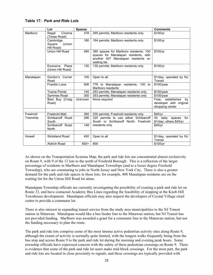
Park and Ride Given the high number of residents commuting to jobs outside the study area – particularly those commuting to New York City and North Jersey – one would expect correspondingly high levels of commuter lots in the study area. As indicated in Table 17 below, there are approximately 4,100 spaces in park and ride lots in the study area (not including Best Buy), all within the four townships. About 4,400 permits for spaces in these lots are on file with the clerks of the townships. The amount of over-
subscription is even higher than it would at first appear, as 550 of the 4,100 spaces are “day rentals” in lots maintained by New Jersey Transit, leaving 3,550 spaces for the 4,400 permit holders. Despite this seeming disparity, several of the lots have a significant number of vacancies on a regular basis, including Regal Cinema in Marlboro, Schibanoff Road South in Freehold Township, and Aldrich Road in Howell. It is possible that over-subscription could be increased to a greater degree.
NJ Transit park and ride lot in Howell.
1 NJ Transit, Monmouth-Ocean-Middlesex Counties Major Investment Study, February 14, 1996. Draft.
28
Table 17: Park and Ride Lots Lot Spaces Comments
Regal Cinema (Texas Road)
378 295 permits; Marlboro residents only $100/yr
Cambridge Square (Union Hill Road)
180 164 permits; Marlboro residents only $100/yr
Union Hill Road 485 385 spaces for Marlboro residents; 100 spaces for Manalapan residents, with another 407 Manalapan residents on waiting list
$100/yr
Marlboro
Exclusive Plaza (Union Hill Road)
130 130 permits; Marlboro residents only $100/yr
Gordon’s Corner Road
100 Open to all. $1/day; operated by NJ Transit
Franklin Lane 506 778 to Manalapan residents; 100 to Marlboro residents
$100/year
Towne Pointe 145 293 permits; Manalapan residents only $100/year Symmes Road 300 353 permits; Manalapan residents only $100/year
Manalapan
Best Buy (Craig Road)
Unknown None required Free; established by developer with original shopping center
Freehold Mall 360 535 permits; Freehold residents only $45/yr Schibanoff Road South
286 45 daily spaces for $1/day; others $45/yr
Freehold Township
Schibanoff Road North
148
325 permits to use either Schibanoff South or Schibanoff North; Freehold residents only $45/yr
Strickland Road 450 Open to all $1/day; operated by NJ
Transit Howell
Aldrich Road 600+ 900 $100/yr As shown on the Transportation Systems Map, the park and ride lots are concentrated almost exclusively on Route 9, with 9 of the 12 lots to the north of Freehold Borough. This is a reflection of the larger percentage of residents in Marlboro and Manalapan Townships (and to a lesser degree Freehold Township), who are commuting to jobs in North Jersey and New York City. There is also a greater demand for the park and ride spaces in these lots; for example, 400 Manalapan residents are on the waiting list for the Union Hill Road lot alone. Manalapan Township officials are currently investigating the possibility of creating a park and ride lot on Route 33, and have contacted Academy Bus Lines regarding the feasibility of stopping at the Knob Hill Townhouse development. Manalapan officials may also request the developers of Crystal Village retail center to provide a commuter lot. There is also interest in expanding transit service from the study area municipalities to the NJ Transit station in Matawan. Manalapan would like a bus feeder line to the Matawan station, but NJ Transit has not provided funding. Marlboro was awarded a grant for a commuter line to the Matawan station, but not the funding necessary to plan the route. The park and ride lots comprise some of the most intense active pedestrian activity sites along Route 9, although the extent of activity is normally quite limited, with the longest walks frequently being from the bus stop and across Route 9 to the park and ride lot during the morning and evening peak hours. Some township officials have expressed concern with the safety of these pedestrian crossings on Route 9. There is evidence that some of the park and ride lot users make mid-block crossings. For the most part, the park and ride lots are located in close proximity to signals, and these crossings are typically provided with
29
crosswalks and pedestrian signal indications. (However, crosswalks and pedestrian signals are absent at many transit stops that lack park and ride lots. This is particularly true of transit stops along Route 9 in Howell Township.)
Pedestrian Pedestrian conditions were reviewed throughout the Western Monmouth study area, with the greatest attention paid to conditions on Route 9 itself, as well as arterials and collectors immediately off Route 9. These are the areas of greatest priority within the study area, largely because they offer a combination of the most intense pedestrian generators and a conspicuous lack of sidewalks.
Pedestrian Priorities Medium to high density residential developments in relatively close proximity to Route 9 should be designated as a high priority in the provision of pedestrian facilities, for several reasons:
1) The higher concentration of pedestrians results in a higher usage of pedestrian facilities. 2) There is a higher concentration of attractions – especially retail uses – within walking distance of
these residential developments. 3) Traffic volumes are higher on roadways closer to Route 9, increasing the exposure of pedestrians
in these areas to motor vehicles. 4) The residents in these developments have a lower average vehicle ownership rate, or may be
completely transit dependent, resulting in a higher percentage of trips by foot. Retail uses within the study area should also be of high priority in the provision of pedestrian facilities. Many retail uses are within walking distance of residential areas off Route 9 and of workers in offices and other uses along the corridor. Further, retail uses typically have a large number of lower-income service workers that may be transit-dependent, and must therefore, by definition, incorporate pedestrian trips into their work commute. Facilities that serve the least mobile populations in the study area – children and the elderly – should always receive attention in the provision of pedestrian facilities. An increasing focus of “smart growth” planning has been the placement of schools in locations to which children could walk, rather than be bussed or carpooled by parents. The construction of Wemrock Elementary School in Manalapan is an example of school construction that fosters sprawl. None of its students will be able to walk there, both because of its distance from residential neighborhoods and because it is located on a county roadway with no pedestrian facilities. Finally, the park and ride lots and transit stops along Route 9 are obvious pedestrian priorities. There are many pedestrian trips in the evening peak hour, when passengers discharged by southbound buses cross Route 9 to return to their vehicles in park and ride lots, the large majority of which are on the northbound side.
Pedestrian Conditions Route 9 is highly deficient for pedestrians, for two primary reasons:
• Lack of sidewalks. • Many land developments are not linked to adjacent properties, through either vehicular or
pedestrian facilities. These two issues are discussed below. With some exceptions, sidewalks are absent on virtually the entire length of Route 9. This is largely due to the historic development patterns along the roadway; parcels have been developed in isolation, and there was little expectation that customers and employees would access a particular use through walking. As pedestrian generators (such as large retail uses, residences directly off the corridor, or transit stops) have accumulated along the corridor, the opportunities for making pedestrian trips have grown. Because of the lack of sidewalks, it is a common occurrence to see people walking in the roadway, or threading

30
their way through developments’ parking lots or along the grass buffers in front. Because of the unpleasant environment for pedestrians, many people choose to drive for trips that would be made by foot in a more urban setting. People without access to motor vehicles have less choice.
Photo on left shows pedestrian walking north along Route 9 in Marlboro. On right, looking west along Tennent Road in Manalapan from the Towne Pointe community entrance. The roadway has neither a sidewalk nor a shoulder of adequate width, leaving this woman and young girl in uncomfortable proximity to traffic.
Photo on left shows a transit shelter along northbound Route 9, in front of the Regal Cinema Park and Ride lot on the border between Marlboro and Old Bridge Townships. There is no sidewalk, which is typical of many transit stops along the corridor. Shortly after this picture was taken, a bus discharged passengers, all of whom walked up the berm and through the shrubbery rather than along the shoulder. Many passengers at this transit stop elect to cross Route 9 here rather than at the signalized intersection with Texas Road to the north. The photo on the right illustrates the obstacles for pedestrians who walk on the northbound side: access to the ramp crosswalk is blocked by the Exxon sign, landscaping, and a light pole. Once across the ramp, pedestrians have to walk in the shoulder or on the grass underneath the Texas Road sign. Sidewalks in new residential developments in New Jersey are regulated by the Residential Site Improvement Standards. Sidewalks in commercial areas are left to the discretion of individual municipalities. While many new developments in the study area are installing sidewalks, too many waivers are granted by the municipalities. Waivers from the requirement to install pedestrian facilities should not be considered except under particularly compelling circumstances. The absence of sidewalks would be less of an issue if appropriate linkages were provided between adjoining land uses along the corridor. Such linkages would permit both motorized and non-motorized users to avoid Route 9 to a much greater extent. They would encourage pedestrian traffic in the corridor, and improve traffic flow on Route 9. To the extent that they enable developers to reduce the number of curb cuts on their property, they would lead to a reduction in vehicular crashes along Route 9. Numerous studies have shown a clear and significant relationship between the number of driveways on urban roadways and the level of crashes.
31
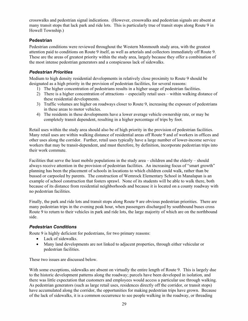
The photo shows a parking lot at Summerton Plaza along Route 9 in Manalapan. Curbing is absent at the end of the parking lot. These adjoining retail plazas could be easily linked, but are not.
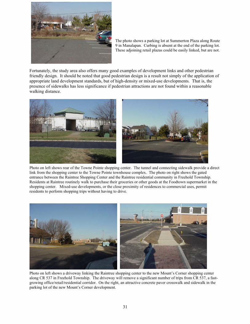
Fortunately, the study area also offers many good examples of development links and other pedestrian friendly design. It should be noted that good pedestrian design is a result not simply of the application of appropriate land development standards, but of high-density or mixed-use developments. That is, the presence of sidewalks has less significance if pedestrian attractions are not found within a reasonable walking distance.
Photo on left shows rear of the Towne Pointe shopping center. The tunnel and connecting sidewalk provide a direct link from the shopping center to the Towne Pointe townhouse complex. The photo on right shows the gated entrance between the Raintree Shopping Center and the Raintree residential community in Freehold Township. Residents at Raintree routinely walk to purchase their groceries or other goods at the Foodtown supermarket in the shopping center. Mixed-use developments, or the close proximity of residences to commercial uses, permit residents to perform shopping trips without having to drive.
Photo on left shows a driveway linking the Raintree shopping center to the new Mount’s Corner shopping center along CR 537 in Freehold Township. The driveway will remove a significant number of trips from CR 537, a fast-growing office/retail/residential corridor. On the right, an attractive concrete paver crosswalk and sidewalk in the parking lot of the new Mount’s Corner development.

32
Existing Traffic Conditions
Current Roadway Features Route 9 is a four-lane, divided land service roadway throughout Monmouth County. At a number of isolated locations, Route 9 has been widened to provide three (3) through lanes – Ryan Road, Aldrich Road, and New Friendship Road – and four through lanes at the Business Route 33 intersection. According to the New Jersey State Highway Access Management Code, Route 9 throughout Monmouth County has a 6A desirable typical section, which defines the master plan cross-section as a six-lane divided roadway with shoulders. The median of Route 9 in the study area north of Casino Drive has a varying width from 10 feet to 36 feet, and south of Casino Drive is a concrete barrier flanked by 3-foot-wide shoulders. Route 9 serves as a regional arterial for commuter traffic destined for employment centers in counties to the north and New York City. It also accommodates local trips to retail uses along the corridor. Along the 19-mile length, there are 26 traffic signal controlled intersections and six (6) grade-separated interchanges. Table 18: Intersection/ Interchange Listing
INTERSECTION MUNICIPALITY INTERSECTION TYPE 1. Alexander Road Howell Township At-grade – signal controlled 2. Estelle Lane Howell Township At-grade – signal controlled 3. Lanes Mill Road Howell Township At-grade – signal controlled 4. New Friendship Road Howell Township At-grade – signal controlled 5. Salem Hill Road Howell Township At-grade – signal controlled 6. Aldrich Road Howell Township At-grade – signal controlled 7. Northwoods Place Howell Township At-grade – signal controlled 8. Interstate 195 Howell Township Cloverleaf interchange 9. Georgia Tavern Road Howell Township At-grade – signal controlled 10. Sunnyside Road Howell Township At-grade – signal controlled 11. West Farm Road Howell Township At-grade – signal controlled 12. U-turn at M.P. 109.2 Howell Township At-grade – signal controlled 13. Casino Drive Howell Township At-grade – signal controlled 14. Strickland Road Freehold Township At-grade – signal controlled 15. U-turn at M.P. 110.8 Freehold Township At-grade – signal controlled 16. Adelphia Road and County Route 524 Freehold Township At-grade – signal controlled 17. U-turn at M.P. 112.1 Freehold Township At-grade – signal controlled 18. Route 79 and Schanck Road Freehold Township At-grade – signal controlled 19. NJ Route 33 Freehold Township Grade-separated partial interchange 20. U-turn at M.P. 113.15 Freehold Township At-grade – signal controlled 21. West Main Street – County Route 537 Freehold Borough Grade-separate diamond interchange 22. Freehold Raceway Mall Freehold Township At-grade – signal controlled 23. Business Route 33 Freehold Township At-grade – signal controlled 24. Route 522 Freehold Township Grade-separated interchange 25. Schibanoff Road Freehold Township At-grade – signal controlled 26. Craig Road Freehold Township At-grade – signal controlled 27. Ryan Road/ Symmes Road Manalapan Township At-grade – signal controlled 28. Taylor Mills Road Manalapan Township At-grade – signal controlled 29. Gordons Corner/ Tennent Road Manalapan Township Grade-separated interchange 30. U-turn at M.P. 119.2 Marlboro Township At-grade – signal controlled 31. Union Hill Road Marlboro Township Grade-separated interchange 32. Newman Springs Road – County Route 520 Marlboro Township At-grade – signal controlled Numerous locations along the corridor, both at-grade and grade-separated, are affected both by peak hour
33
traffic demand, and substandard geometric design features. These locations are:
• Route 524 intersection • Route 79/ Schanck Road intersection • Route 537 interchange • Route 522 interchange • Taylors Mill Road intersection • Gordon’s Corner/ Tennent Road interchange • Route 520 intersection
NJ Route 33 west of Route 9 is a four-lane divided roadway. It is a limited access roadway from Route 9 to Business Route 33 with grade-separated interchanges and is a land service roadway with at-grade signalized intersections west of Business Route 33. For the purpose of this study, Orth-Rodgers has analyzed traffic conditions at the Woodward Road and Millhurst Road intersections.
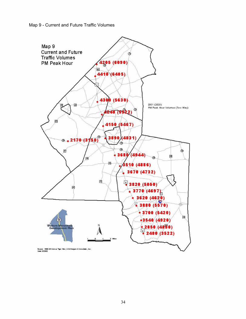
Current Traffic Volumes Daily and hourly traffic volumes have been compiled for the corridor. The Monmouth County 1999 Baseline Conditions Inventory, NJDOT historical data, and traffic studies associated with site plan applications on the corridor were reviewed, and 2001 and 2002 traffic data was collected by Orth-Rodgers. Peak hour data on NJ Route 33 west of the Route 9 corridor was also obtained. Data was not available at all 32 locations along the Route 9 corridor and, therefore, traffic conditions were assessed based on observed field conditions. The average daily traffic volumes (ADT) along the corridor range from a high of 65,400 in Manalapan and Marlboro Townships, to a low of 39,200 vehicles south of Lanes Mill Road in Howell Township. Traffic growth from 1985 to 2000 at various points along the corridor ranges from 30.5 percent to 47.8 percent, or a per annum of 1.75 percent to 2.6 percent, with the higher growth rate experienced north of Route 33. The ADT for Route 33 in Manalapan Township is 22,400. The weekday evening peak hour was selected as the critical study period for analysis due to commuter demands and retail oriented trips. Current Route 9 peak hour traffic volumes range from 4,410 vehicles at the Route 520 intersection in Marlboro to 2,480 vehicles at the Alexander Road intersection in Howell, as detailed in Map 9, Current and Future Traffic Volumes. The two-way peak hour volume on Route 33 west of Millhurst Road is 2,170.
34
Map 9 - Current and Future Traffic Volumes
35
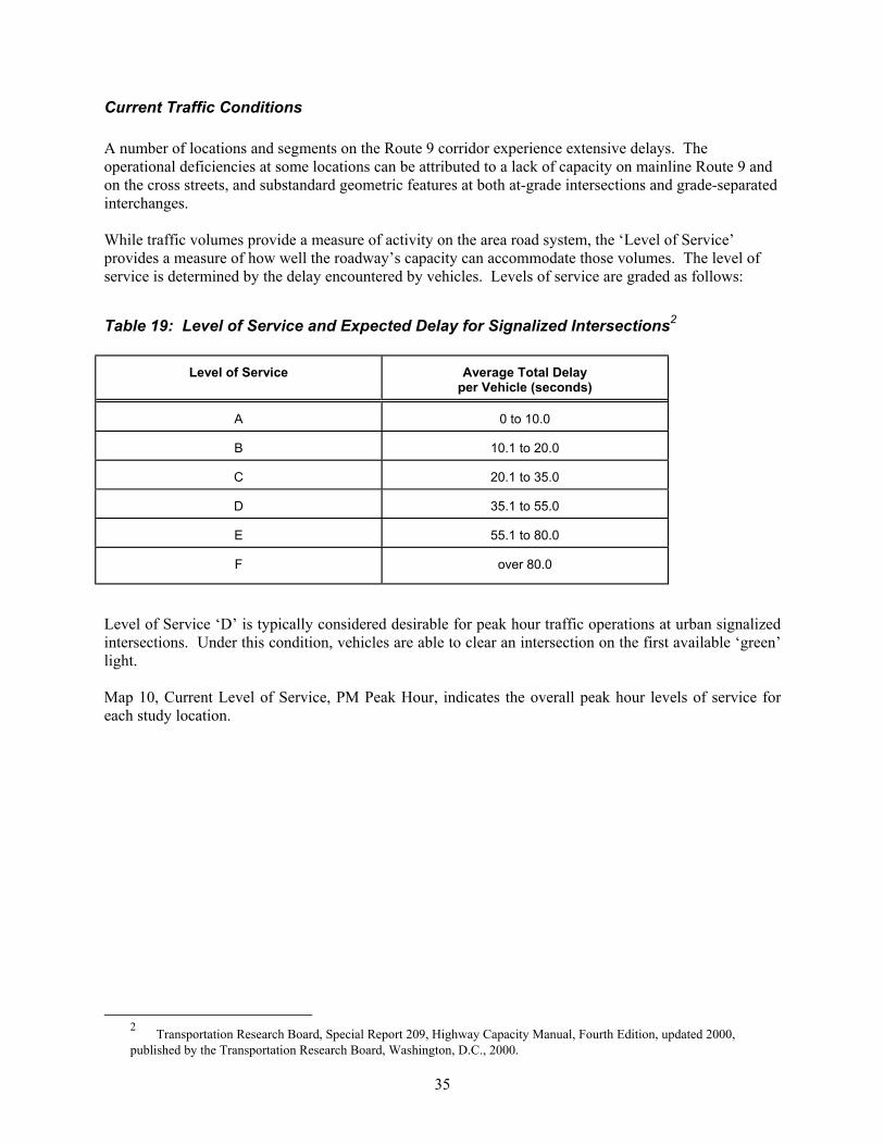
Current Traffic Conditions A number of locations and segments on the Route 9 corridor experience extensive delays. The operational deficiencies at some locations can be attributed to a lack of capacity on mainline Route 9 and on the cross streets, and substandard geometric features at both at-grade intersections and grade-separated interchanges. While traffic volumes provide a measure of activity on the area road system, the ‘Level of Service’ provides a measure of how well the roadway’s capacity can accommodate those volumes. The level of service is determined by the delay encountered by vehicles. Levels of service are graded as follows:
Table 19: Level of Service and Expected Delay for Signalized Intersections2
Level of Service
Average Total Delay per Vehicle (seconds)
A
0 to 10.0
B
10.1 to 20.0
C
20.1 to 35.0
D
35.1 to 55.0
E
55.1 to 80.0
F
over 80.0
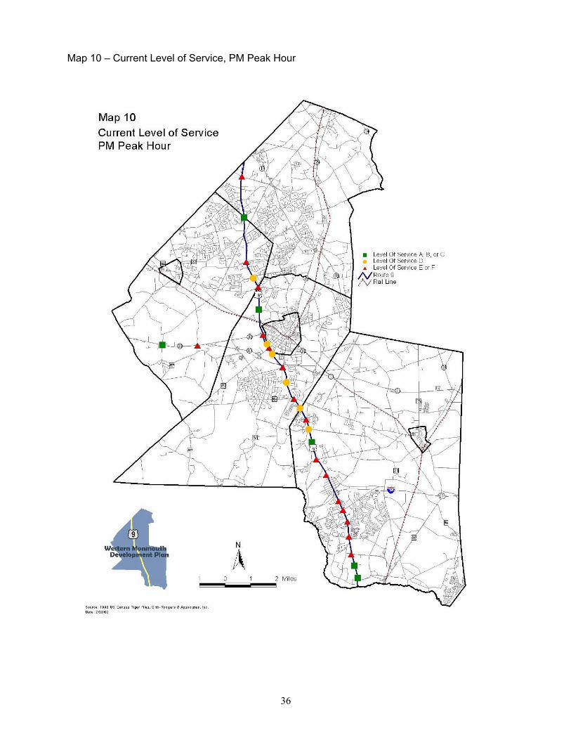
Level of Service ‘D’ is typically considered desirable for peak hour traffic operations at urban signalized intersections. Under this condition, vehicles are able to clear an intersection on the first available ‘green’ light. Map 10, Current Level of Service, PM Peak Hour, indicates the overall peak hour levels of service for each study location.
2 Transportation Research Board, Special Report 209, Highway Capacity Manual, Fourth Edition, updated 2000, published by the Transportation Research Board, Washington, D.C., 2000.
36
Map 10 – Current Level of Service, PM Peak Hour

37
Following is a summary of both operational and geometric deficiencies at critical locations:
1. Aldrich Road – Due to the traffic volume demands on the eastbound and westbound approaches, insufficient ‘green’ time is available to Route 9; during the evening peak hour, southbound traffic extends through the intersection of Northwoods Place.
2. Adelphia Road/ County Route 524 – Extensive delays are experienced at this location during
peak hour periods due to the volume demands on Route 9 and Adelphia Road. The delays are compounded by the substandard design of the northbound and southbound near-side jughandles.
3. Route 79 and Schanck Road – This location has historically been known for its extensive
delays. The operational efficiency is affected by the traffic demands on all approaches, the substandard geometric design of the jughandles, and the acute angle of the intersecting streets of Route 79 and Schanck Road.
4. County Route 522 – The geometric design of the northbound and southbound on- and off-
ramps and the substandard lengths of the acceleration and deceleration lanes on mainline Route 9 affect Route 9 traffic flow.
5. Craig Road/ East Freehold Road – This intersection experiences extensive delays for both
mainline Route 9 and the east-west approaches. The location of Pond Road, approximately 200 feet east of Route 9, impacts the operational efficiency of this intersection.
6. Taylor Mills Road – There are significant volumes on the east-west approaches. The
operations of the near-side jughandles are affected by substandard design; left turns from the jughandles are difficult due to the queuing of vehicles from the traffic signal.
7. Gordons Corner Road and Tennent Road interchange – This complex interchange serves two
regional collector east-west roadways, it has the following substandard design features: horizontal alignment of ramps to and from Route 9, substandard auxiliary lanes, and marginal sight distance for unsignalized movements within the interchange.
8. Route 520 – There are significant volumes on the east-west approaches. The operations of the
near-side jughandles are affected by substandard design; left turns from the jughandles are difficult due to the queuing of vehicles from the traffic signal.
It is important to note that there are other time periods that experience delay and congestion along the corridor, including the morning weekday peak hour and the Saturday midday period.

38
Future Traffic Conditions
Planned Roadway Improvements There are numerous short-term and long-term roadway improvements proposed along and adjacent to the Route 9 corridor, as follows:
• Lanes Mill Road and Route 9 Restriping of the eastbound approach to provide an exclusive left-turn lane and a shared left/ through/ right-turn lane is proposed in conjunction with the construction of the Howell Consumer Square development.
• New Friendship Road and Route 9
In conjunction with the Howell Consumer Square development, Route 9 northbound will be widened to provide a third through lane. The northbound reverse jughandle will be widened as a two-lane ramp and will be restriped on the approach to Route 9 to provide an exclusive left-turn lane and a shared left/ through lane.
• County Route 524 and Route 9
The New Jersey Department of Transportation (NJDOT) is preparing plans for the construction of northbound and southbound far-side jughandles and the realignment of County Route 524 through the intersection.
• County Route 522 and Route 9 Interchange
NJDOT is preparing plans to widen the Route 9 bridge in order to provide acceleration and deceleration lanes on Route 9 to the ramps.
• County Route 520 and Route 9
In conjunction with the retail development in the northwest quadrant of the intersection, widening of Route 9 southbound is proposed to provide three (3) through lanes, as well as widening on Route 520 to provide four (4) lanes on the eastbound and westbound approaches controlled by a three-phase traffic signal. In addition, Marlboro Township has secured funding to pursue the construction of northbound and southbound far-side jughandles to eliminate the left-turn movements from the existing near-side jughandles.
The intersection of Route 79/ Schanck Road and Route 9 has been the subject of numerous feasibility studies. It has been proposed to address the substandard weave conditions on Route 9 southbound by eliminating the Route 33 eastbound off-ramp to Route 9 near-side jughandle to Shanck Road, and the left-turn movement from the southbound near-side jughandle onto Shanck Road, through the construction of a far-side jughandle. Further, the alignment of Route 79 and Shanck Road would be improved to optimize traffic flow during peak periods.

39
There are numerous other roadway improvements proposed off the Route 9 corridor that will provide secondary benefits to the Route 9 corridor and they are as follows:
• Completion of East Freehold Road between Route 537 and Robertsville Road – Freehold Township.
• Realignment and reconstruction of Halls Mill Road from Route 33 to County Route 524 –
Freehold Township.
• Installation of a traffic signal at Halls Mill Road and Willowbrook Road – Freehold Township.
• Installation of a traffic signal at Halls Mill Road and Three Brooks Road – Freehold Township.
• Installation of a traffic signal at realigned Halls Mill Road and Route 524 – Freehold Township.
• Installation of a traffic signal at Millhurst Road and Woodward Road/ Main Street – Manalapan Township.
• Widening and installation of a new traffic signal at County Route 522 and Tennent Road –
Manalapan Township.
• Widening and installation of a new traffic signal at Tennent Road and Taylor Mills Road – Manalapan Township.
• Completion of Route 33 limited access roadway from Halls Mill Road to Route 33 – Howell
Township.
• Construction of a roadway (Trotters Way Extension) from Route 537 to Route 9 southbound lanes – Freehold Township.
• Installation of traffic signals at Stillwells Road and Route 547 – Freehold Township.
Future Traffic Volumes Year 2020 traffic volumes were determined based on planned development activity, County projections for population and employment, and local zoning. Historical traffic data, as well as planned roadway improvements were also considered in establishing future traffic volumes. By the year 2020, it is anticipated that the volumes on Route 9 will increase by an average of 42 percent. The peak hour traffic volumes on Route 9 are estimated to be highest in Marlboro Township (6,405 vehicles) and lowest in Howell Township south of Alexander Drive (3,590 vehicles). Traffic on a number of local and County roads are expected to increase substantially due to either approved or planned developments within the study area. NJ Route 33 two-way traffic volumes are expected to increase to 3,150 vehicles. Figure 1 depicts traffic volume comparisons of key locations along the Route 9 corridor; Map 10 (page 34) depicts current and future traffic volumes for all locations.

40
Figure 1 – Traffic Volume Comparison
2480
38803680
41504410
2170
3522
5570 5467
6405
3150
3820
50504944
0
1000
2000
3000
4000
5000
6000
7000
RTE. 9 South ofLanes Mill Rd
RTE. 9 South ofI-95
RTE. 9 North ofW. Farm Rd.
RTE. 9 North ofCR 524
RTE. 9 North ofBusn. 33
RTE. 9 South ofRTE. 520
RTE. 33 Westof Millhurst Rd.
Even
ing
Peak
Hou
r Vol
umes
(Tw
o-W
ay)
2001 Traffic Volumes2020 Traffic Volumes
Future Traffic Conditions As peak hour volumes on Route 9 increase, so will the levels of congestion. Based on projected 2020 traffic volumes and taking into consideration the short-term and long-term roadway improvements, the majority of signalized intersections along the study corridor will be operating at a Level of Service ‘F’. (Map 11, 2020 Level of Service) In order to improve the levels of service at many of the intersections along the corridor, it will be necessary to provide six lanes of travel on Route 9 consistent with the NJDOT Master Plan (Desirable Typical Section). To provide the additional travel lane, right-of-way should not be required since the grass median can be used north of Strickland Road to provide the additional travel lane with minimal impacts onto existing properties. However, at the four grade-separated interchanges north of Route 79 (Route 537, Route 522, Gordons Corner Road, and Union Hill Road), modifications and/or widening of the bridge structures would be required to provide six mainline travel lanes. South of Strickland Road, the construction of a third lane would require widening that could potentially impact existing developed parcels and require land acquisition. As an example of the required cross-section, at Aldrich Road it would be necessary to provide four approach lanes on Route 9 southbound consisting of three through lanes and an exclusive right-turn lane. Providing the six-lane cross-section will not resolve all deficient levels of service along the corridor, but as detailed in Map 12, 2020 Levels of Service with Improvements, a number of intersections will benefit. However, at intersections such as Route 79 and Shanck Road, Route 520 and Aldrich Road, desirable levels of service cannot be achieved. This analysis also considered capacity enhancement to the side street approaches at various locations. To a certain degree, they will help to reduce the delays, but a Level of Service ‘D’ cannot be achieved. The future traffic volumes at a number of locations exceed the capacity of what can be processed at an at-grade, signalized intersection. Therefore, to provide acceptable levels of service, a grade-separated interchange would be necessary which would have significant impacts on adjacent properties.
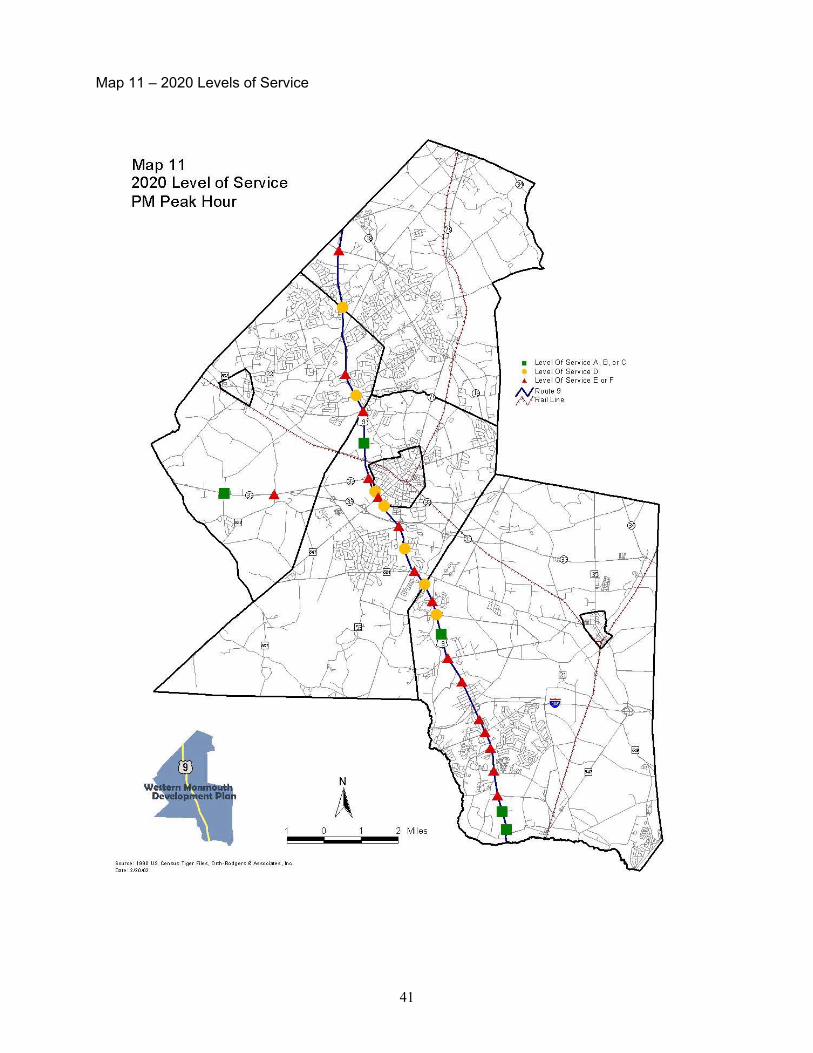
41
Map 11 – 2020 Levels of Service

42
Map 12 – 2020 Levels of Service with Improvements
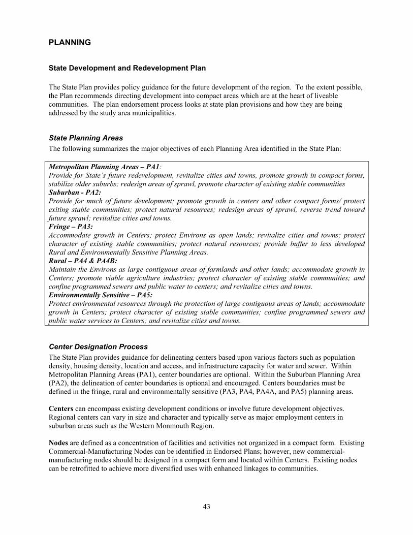
43
PLANNING
State Development and Redevelopment Plan The State Plan provides policy guidance for the future development of the region. To the extent possible, the Plan recommends directing development into compact areas which are at the heart of liveable communities. The plan endorsement process looks at state plan provisions and how they are being addressed by the study area municipalities.
State Planning Areas The following summarizes the major objectives of each Planning Area identified in the State Plan: Metropolitan Planning Areas – PA1: Provide for State’s future redevelopment, revitalize cities and towns, promote growth in compact forms, stabilize older suburbs; redesign areas of sprawl, promote character of existing stable communities Suburban - PA2: Provide for much of future development; promote growth in centers and other compact forms/ protect exiting stable communities; protect natural resources; redesign areas of sprawl, reverse trend toward future sprawl; revitalize cities and towns. Fringe – PA3: Accommodate growth in Centers; protect Environs as open lands; revitalize cities and towns; protect character of existing stable communities; protect natural resources; provide buffer to less developed Rural and Environmentally Sensitive Planning Areas. Rural – PA4 & PA4B: Maintain the Environs as large contiguous areas of farmlands and other lands; accommodate growth in Centers; promote viable agriculture industries; protect character of existing stable communities; and confine programmed sewers and public water to centers; and revitalize cities and towns. Environmentally Sensitive – PA5: Protect environmental resources through the protection of large contiguous areas of lands; accommodate growth in Centers; protect character of existing stable communities; confine programmed sewers and public water services to Centers; and revitalize cities and towns.
Center Designation Process The State Plan provides guidance for delineating centers based upon various factors such as population density, housing density, location and access, and infrastructure capacity for water and sewer. Within Metropolitan Planning Areas (PA1), center boundaries are optional. Within the Suburban Planning Area (PA2), the delineation of center boundaries is optional and encouraged. Centers boundaries must be defined in the fringe, rural and environmentally sensitive (PA3, PA4, PA4A, and PA5) planning areas. Centers can encompass existing development conditions or involve future development objectives. Regional centers can vary in size and character and typically serve as major employment centers in suburban areas such as the Western Monmouth Region. Nodes are defined as a concentration of facilities and activities not organized in a compact form. Existing Commercial-Manufacturing Nodes can be identified in Endorsed Plans; however, new commercial-manufacturing nodes should be designed in a compact form and located within Centers. Existing nodes can be retrofitted to achieve more diversified uses with enhanced linkages to communities.
44
Cores are defined as pedestrian-oriented areas of commercial and civic uses serving the surrounding municipality. The identification of cores is encouraged by the State Plan; for example, the Freehold Borough central business district would be defined as a core.
Western Monmouth Region State Planning Areas Map 13 shows the State Plan Policy Map for the Western Monmouth Region. Other features shown on the Policy Map include endorsed and proposed centers, Critical Environmental Sites (CES) and Historic and Cultural Sites (HCS) and Park and Recreation Areas. The State Plan defines Centers as Regional Centers, Towns, Villages and Hamlets; these Centers can be, in turn, Designated, Proposed or Identified. Designated and proposed centers are shown on the Policy Map; identified centers are only listed within the Plan. Freehold Borough, a Town, is the only designated center in the study area. There are two proposed centers: the Freehold Regional Center and the Englishtown Village Center. Finally, there are three existing centers: Marlboro Village, Farmingdale Town, and Adelphia Village. Although defined as existing, these centers have not yet been officially designated. The Monmouth County Cross Acceptance Report (1999) also identified the Route 9 corridor as a Corridor Center to be defined, and also recommended that Ramtown be considered as a hamlet. It is recommended that the county and municipalities identify new centers and/or confirm existing centers as part of the Plan, to be designated through the NJ OSP Plan Endorsement process. No nodes are currently identified for the Western Monmouth Region in the State Plan. Nodes are an important consideration for the Route 9 corridor with its numerous commercial centers of varying sizes, from regional shopping centers (Freehold Raceway Mall), to dozens of small community retail and strip centers, with big box retail centers (such as those anchored by Home Depot and Walmart) in between. Given the pedestrian activity inherent in park and ride locations, these places somewhat naturally lend themselves to consideration as “nodes” which can be developed with greater intensity in the future. Ideally, there would be both high-density residential development at these nodes – giving residents the option of commuting without having to drive on Route 9 – and retail services that commuters could patronize on their way to and from work. The following briefly describes the planning areas and center designations for the study area municipalities. Englishtown is located in PA2. It is shown as proposed Village Center on the State Plan Policy Map. Farmingdale is located in PA1. It is an Identified Town in the State Plan. Freehold Borough is located in PA1. It is a Designated Town in the State Plan. A majority of the lands in Freehold Township, and all lands within the Freehold Regional Center, are located in PA2. Virtually all of this PA2 area lies north of CR 524, although there is a large swath between CR 524 and Stone Hill Rd. To the north of Freehold Borough, Lake Topanemus anchors a PA3 area, and the Durand Conservation Area helps define a PA5 area. To the south of CR 524, the Turkey Swamp State Lands and Park are bracketed by PA5 areas. This section has a number of County designated scenic roadways. Howell Township has the most diverse planning area arrangement of the seven municipalities in the Western Monmouth Region. Route 9 is the spine of the PA2 area. The northwest and southwest corners are PA3. Route 33, a corridor zoned for highway development, is found within PA4A or PA5; other than Route 9, the latter two areas dominate the Township, with the exception being Ramtown (PA2).

45
Map 13 – State Plan Policy Map

46
PA2 dominates the section of Manalapan Township north of Route 522, and along Route 33. South of Englishtown is within PA4B. South of Route 33 is in PA3. (The Township has indicated that they wish this area to be better preserved through PA4B.) No Manalapan Centers are delineated, proposed, or identified in the State Plan. A majority of Marlboro is in PA2 reflecting existing suburban development along the Route 9, Route 18 and Route 79 corridors. The eastern section of the Township is within PA5, which encompasses the Burnt Fly Bog area. The PA 3 provides transition between the more critical sensitive areas and the low-density residential development occurring in the majority of the Township. Marlboro Village is identified as a Village Center in the Plan.
Municipal Plans The master plans and other planning studies of the study area municipalities were reviewed, with particular attention given to land use, transportation and conservation objectives. Information on municipal planning objectives was also gathered from municipal interviews, as well as the 1999 Monmouth County Cross Acceptance Report and 2001 Monmouth County Municipal Needs Survey findings. Table 20: Municipal Planning Initiatives Municipality Master
Plan Master Plan Reexamination
Other Plans
Englishtown 1990 1995 Farmingdale 1996 Freehold Borough 1980 1995; draft in progress Freehold Township 1998 2000 Open Space Plan, 1997 Howell 1994/1995 2001 Manalapan 1991 2001,1999, 1994 Open Space and Conservation Plan, 2001; Farmlands
Preservation Plan, 2001 Marlboro 1997 Draft in progress Open Space Plan, 2001
Englishtown Land Use: Planning efforts in Englishtown are focused on redevelopment. The Master Plan calls for revitalizing Main Street through the provision of additional off-street parking, streetscape improvements and the rehabilitation of second floor apartments. Some streetscape improvements have already occurred through the Borough’s participation in the Neighborhood Preservation Program. Redevelopment opportunities are also considered in the General Commercial district along Railroad Avenue near the municipal border. Englishtown is shown as a proposed Existing Village in the State Plan. Transportation: Most of the Borough roads are county roads. Congestion on Main Street is a periodic occurrence on weekends, as visitors to the Englishtown Auction and the Old Bridge Raceway pass through the Borough. Conservation: A conservation zone for floodplains and wetlands extends through much of the borough; all land within this zone is designated as a conservation easement for permanent open space. Cluster zoning is permitted to accommodate development outside of conservation zones.
47
Farmingdale Land Use: Due to state-imposed limitations on water drawdown from the Englishtown aquifer, lands in Farmingdale cannot be developed for residential uses at moderate or high density, and the Master Plan recommends limiting development. Future development will thus focus on revitalization efforts, especially in the village center. The Borough has adopted a density bonus provision to promote better design in the Village Commercial district; however, the language is very broad without specific standards in place. More attractive lighting and streetscaping is desired. The industrial lands along the railroad right-of-way offer future redevelopment opportunities, together with commercial sites on Main Street. The Borough is shown as an identified Existing Village in the State Plan and is interested in center designation. Transportation: The Borough supports the MOM line and the proposed stop in Farmingdale, due to the expected economic benefit to the business district. However, there is little space in Farmingdale itself for a station. Residents have expressed interest in seeing a bike path connect the Borough to Allaire State Park, and other bike facilities. With the high number of retirees in the Borough, a bus shuttle to the train station and other activity centers is considered desirable to explore. Conservation: The Borough ordinances encourage conservation easements along stream corridors, which do not permit grading, or removal of vegetation.
Freehold Borough Land Use: Freehold Borough actively promotes downtown revitalization through its Special Improvement District. Commercial activity has picked up in the downtown in the evening in recent years; greater retail activity downtown would be possible if the County Courthouse were more accessible. Although continued economic revitalization is desirable, the Borough would not like to see large scale structures or intensive development in its downtown. The Borough has received Regional Contribution Agreements to support housing rehabilitation and new construction, and the County/Borough Yard is currently being redeveloped as an assisted living complex. The Borough is considering allowing professional offices along West Main Street, and retail uses on Throckmorton Avenue. Several vacant industrial properties at the end of Mechanic Street, along the Freehold Southern Branch rail line, are slated for redevelopment as a skating rink. This tract is within walking distance to the downtown, offering unique redevelopment opportunities. Freehold Borough is a designated Town in the State Plan. Transportation: The Borough experiences traffic congestion downtown due to the convergence of Route 79 and CR 537, but the future diversion of trips onto the Freehold bypass ring road may improve conditions. Due to limited land downtown, the Borough has considered building a parking deck. Freehold has supported the MOM line in the past, but there is concern that traffic generated by a rail station downtown may add to congestion. Borough has no planned pedestrian or bicycle improvements, but supports using the abandoned Freehold-Matawan railroad right-of-way for regional walkways and bikeways.
48
Conservation: Freehold Borough participated in the regional effort to protect Lake Topanemus. A minimum setback is required to conserve stream corridors.
Freehold Township Land Use: The Freehold Regional Center was planned within Freehold Township to provide a diversified employment and tax base. Its location at the intersection of Route 9, Route 33 and Route 79 provides access to a regional highway and transit system. It also includes Freehold Borough. The boundaries of the Freehold Regional Center are to be confirmed. Under a court settlement agreement, a Village Commercial site is planned on Route 537 south of the Route 33 bypass. The Township has adopted zoning ordinances for mixed non-residential use developments including the Village Center Zone. However, residential uses are not permitted in these zones. There are some areas suitable for redevelopment along Route 9, including Gordon Lumber, the Freehold Mall, and the Pathmark Shopping Center. The Township would like to develop more attractive design standards for commercial development, possibly of a colonial theme. The 2000 Master Plan Reexamination Report also recommended developing architectural design standards for properties adjacent to the Monmouth Battlefield State Park. A low-density zone (10 acres) was recently established for the area around Turkey Swamp, which is consistent with State Plan policies for PA5 areas. Land around the Lake Topanemus Watershed in the northern section of the Township has recently been downzoned to 3-acre lots with no public sewer extensions. A lower density residential district is zoned around the Monmouth Battlefield State Park to provide a transition to the more intensive suburban development surrounding this area. Transportation: Freehold requires linkages of parking between individual commercial lots. Pedestrian and road connections between residential and commercial developments have met with neighborhood opposition. The County is acting to install new sidewalks along CR 537 proximate to Freehold Raceway Mall. Conservation: The 2000 Master Plan Reexamination Report recommends protecting sensitive environmental features within the Metedeconk and Toms River watersheds in southern Freehold Township. Both watersheds are designated as non-service areas for sanitary sewer by the Water Quality Management Plan. Freehold has instituted several preservation ordinances including the protection of groundwater, floodplains, and the headwaters of streams. The Township has also implemented a Heritage tree ordinance which constrains development by requiring preservation of certain species and size of trees
Howell Land Use: Howell’s growth management strategy is to acknowledge existing growth areas, to concentrate development in these areas, and to preserve what is left. The three growth areas identified in the 1994 Master Plan include Ramtown, Adelphia and Candlewood; residential growth in recent years has coincided with the first two areas, and has also occurred in West Howell. The Township would also like to promote nonresidential development along Route 9 and Route 33, and may consider a village center development on Route 33. The 2001 Master Plan Reexamination recommends creating a “Main Street” image along CR 524 (Adelphia Road). Adelphia is currently shown on the State Plan as an identified Existing Village.
49
Howell’s growth management approach established lot sizes outside centers to be low to very low density. A community development boundary was established which provided abrupt density changes. This community development area encompasses the Route 9 corridor and higher density residential development abutting the corridor. Buffering rather than transition uses protect adjoining residential areas. (A 50’ perimeter buffer is required around all major subdivisions.) Cluster development is permitted only in the ARE (rural/agriculture) zones. The sanitary sewer service area is seen as the prime support of growth management policies by limiting future development outside of the growth centers. The 2001 Master Plan Reexamination cited concerns over “rolling sprawl” in the areas of Howell covered by one-acre zoning. Developers have found the two-acre zoning with one-acre cluster to be desirable. The 2001 Reexamination makes a blanket recommendation for reducing the intensity of development on all undeveloped lands, and for retaining the Township’s rural character. The 1994 Master Plan recommended downzoning certain areas along Route 33 from highway development to low density residential due to significant environmental constraints. General commercial and light industrial zones are focused along the Route 33 corridor; on the west adjacent to the Freehold Township border and on the east near the Wall Township border. However, there is currently no sewer infrastructure serving this area. Improved sanitary sewer service is being planned for Route 9 (with an initial focus to the south of Lanes Mill Road) and Route 33 to encourage future non-residential development. The updated wastewater management plan, when adopted, will need to be assessed to certify compatibility with the State Plan. Transportation: The 2001 Reexamination Plan states that the issue of a future rail station needs to be re-examined, given NJ Transit plans for the MOM line. Pedestrian connections have been waived in many residential developments. Connections from residential areas to commercial centers also need to be addressed. There are no plans for improving pedestrian or bicycle facilities at this time. Conservation The 2001 Master Plan Reexamination recommends establishing an Agricultural/Rural Conservation (ARC) district for actively farmed lands. The Reexamination also recommends designating environmentally sensitive areas as an Environmental Resource, but does not state the implications of such a designation. The 2001 Plan also suggests removing cluster development as an option in ARE-2 and ARE-3 districts not served by sanitary sewer and potable water facilities. Some residents believe that the cluster ordinance has been lenient in allowing the creation of higher residential densities.
Manalapan Land Use Policy: The Township Master Plan promotes an established suburban development pattern in the northern Township; rural development of low density residential and agricultural uses west of Millhurst Road and south of the Route 33 corridor; and planned residential and non-residential development along Route 33 corridor. Route 33 has been planned as a Special Economic District (SED) to provide for the opportunity of high-end jobs. The 2001 Master Plan Reexamination recommends establishing the Village Commercial district on Route 33 as a Planned Commercial district, partly with the goal of preventing development of a typical big box center. A high priority is given to the preservation and conservation of open space. The 2001 Master Plan Reexamination recommends establishing a Residential Environmental district with 3-acre zoning, and a Rural Agricultural district with 5 to 6-acre zoning. It also calls for a farmland preservation subdivision, in which 70% of the tract is permanently preserved through an easement purchase, and in which the remaining 30% could be developed, with residential density not exceeding 50% of the total gross density.
50
No Centers are currently identified in Manalapan; however, the Township has expressed interest in designating nodes and cores as part of a regional center. Manalapan has requested the State to reclassify the PA3 designation south of Route 33 to PA4A due to critical environmental sites and farmland preservation objectives. Transportation: Residents are concerned that traffic volumes have increased on back roads in Manalapan due to motorists avoiding Route 9. The Township has lowered density in certain areas to reduce additional traffic. Although there are five park and ride lots – more than any other study area municipality – there is unmet demand for spaces. The Township supports the provision of direct bus service from Township commuter lots on Route 9 to the Matawan rail station but is not interested in running a shuttle service itself. Potential bus service with commuter parking along Route 33 to support planned development such as Knob Hill, the Villages, and the Battleground Country Club is currently being pursued. The Township is pursuing incorporating commuter lot facilities into future development along Route 33, such as the planned Crystal Village retail center. The Township requires connections between shopping centers; pedestrian connections to commercial uses may be considered but are not required by ordinance. The Township has submitted an application to NJ DOT Transportation Trust Fund to construct missing sidewalk linkages. The Township supports the Freehold Secondary Branch MOM line, but would prefer that the station be located outside the municipality. Conservation: The Township’s recently adopted Open Space and Conservation Plan and Farmland Preservation Plan supports acquisition and preservation of over 2,000 acres of farmlands and open space. The 2001 Plan supports interconnected system of open space greenways along the creeks and from Monmouth Battle Field as part of the Crossroads of the American Revolution Greenways Project. Manalapan has stream corridor protection, slope protection and landmark protection ordinances in place.
Marlboro Land Use: Marlboro is most developed in its southwest quadrant (the area bracketed by Route 9 and Route 18), although there are also medium to high density residential developments and commercial uses at a number of places along Route 79. The Master Plan calls for maintaining low density in the east and west central portions of the Township, and for decreasing the residential density in undeveloped parts of the Township. Marlboro has a significant redevelopment option with the closure of Marlboro State Hospital. The property is currently in the Agriculture/Land Conservation zone, which permits 10-acre lots. The Township is pursuing acquisition of the property from the State for redevelopment of core property for corporate offices, conference center, golf course and high-end retail, with adaptive reuse of other buildings for municipal or educational uses. Limited residential uses are desired by the Township. Because of the environmentally sensitive features on the site, the Township is not interested as designation of this property as a Center. However, the Township is interested in a Regional Corridor Center designation for Route 9. The Marlboro Village Center has been is identified in the State Plan. This area is being renovated through private initiatives. Transportation: Marlboro supports improved bus transportation, and received a grant for initiating a commuter shuttle to Matawan Train Station; however, Township lacks funding for route planning. There is a strong demand

51
for parking spaces – from both Marlboro and Manalapan residents – at the commuter parking lots along Union Hill Road. The Township supports the MOM rail line, but not on the abandoned Freehold-Matawan branch. Township does not currently require pedestrian connections between commercial centers, or between residential and commercial areas. Pedestrian crossings of Route 9 have been identified as a significant problem, particularly by the commuter lots. Conservation: There are no lands currently planned for agriculture easements or acquisition. The Township is seeking to acquire land or easements along stream corridors, and to acquire environmentally sensitive land in other areas. The 2001 Open Space Plan identifies about 2,700 acres of agricultural land, and over 2,000 acres of vacant land for potential acquisitions. The Township supports clustering to preserve agricultural lands and has an agriculture land conservation zone; however, the Township does not permit non-contiguous clustering.
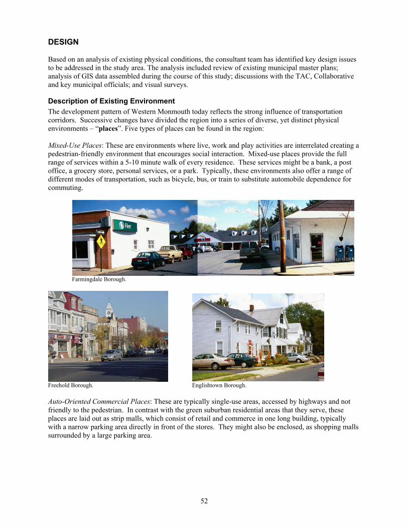
52
DESIGN Based on an analysis of existing physical conditions, the consultant team has identified key design issues to be addressed in the study area. The analysis included review of existing municipal master plans; analysis of GIS data assembled during the course of this study; discussions with the TAC, Collaborative and key municipal officials; and visual surveys.
Description of Existing Environment The development pattern of Western Monmouth today reflects the strong influence of transportation corridors. Successive changes have divided the region into a series of diverse, yet distinct physical environments – “places”. Five types of places can be found in the region: Mixed-Use Places: These are environments where live, work and play activities are interrelated creating a pedestrian-friendly environment that encourages social interaction. Mixed-use places provide the full range of services within a 5-10 minute walk of every residence. These services might be a bank, a post office, a grocery store, personal services, or a park. Typically, these environments also offer a range of different modes of transportation, such as bicycle, bus, or train to substitute automobile dependence for commuting.
Farmingdale Borough.
Freehold Borough. Englishtown Borough. Auto-Oriented Commercial Places: These are typically single-use areas, accessed by highways and not friendly to the pedestrian. In contrast with the green suburban residential areas that they serve, these places are laid out as strip malls, which consist of retail and commerce in one long building, typically with a narrow parking area directly in front of the stores. They might also be enclosed, as shopping malls surrounded by a large parking area.
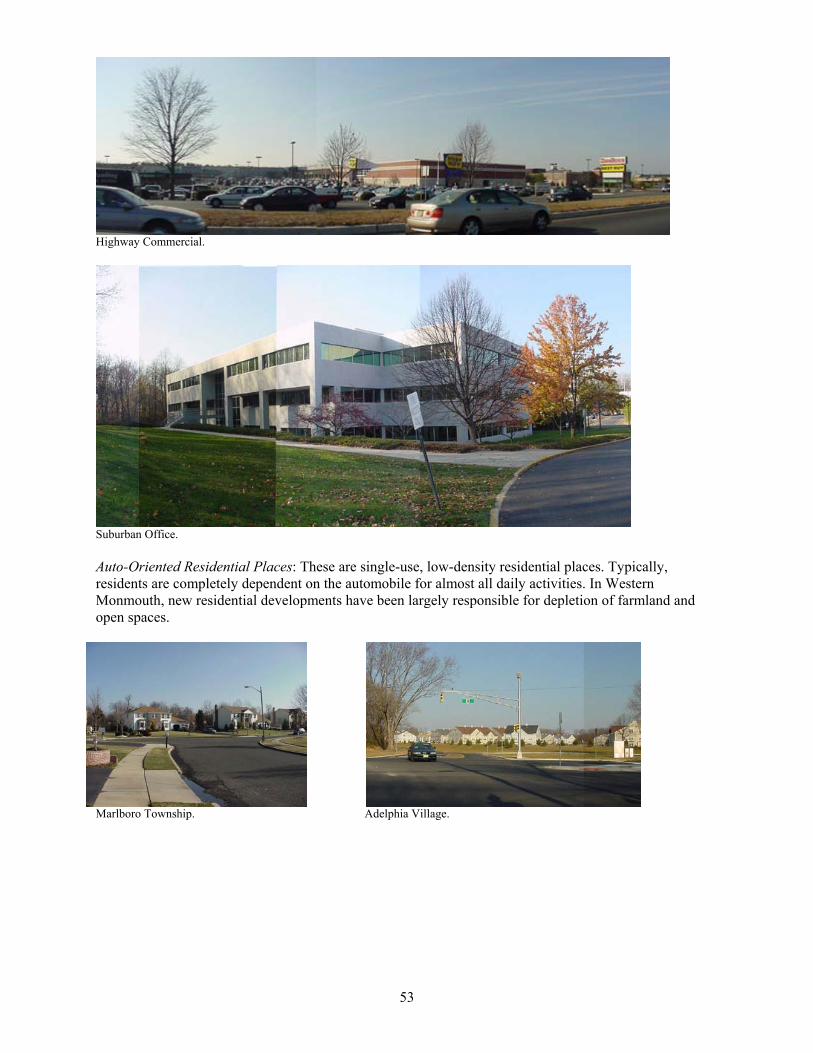
53
Highway Commercial.
Suburban Office. Auto-Oriented Residential Places: These are single-use, low-density residential places. Typically, residents are completely dependent on the automobile for almost all daily activities. In Western Monmouth, new residential developments have been largely responsible for depletion of farmland and open spaces.
Marlboro Township. Adelphia Village.
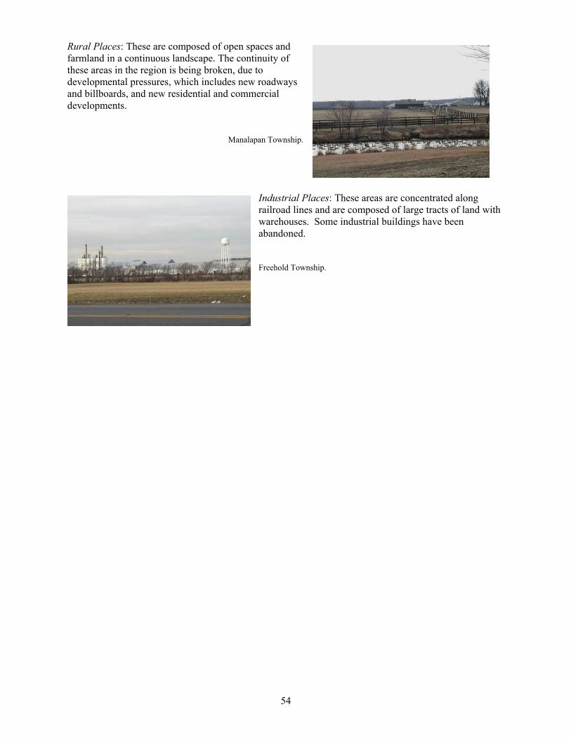
54
Rural Places: These are composed of open spaces and farmland in a continuous landscape. The continuity of these areas in the region is being broken, due to developmental pressures, which includes new roadways and billboards, and new residential and commercial developments.
Manalapan Township.
Industrial Places: These areas are concentrated along railroad lines and are composed of large tracts of land with warehouses. Some industrial buildings have been abandoned. Freehold Township.
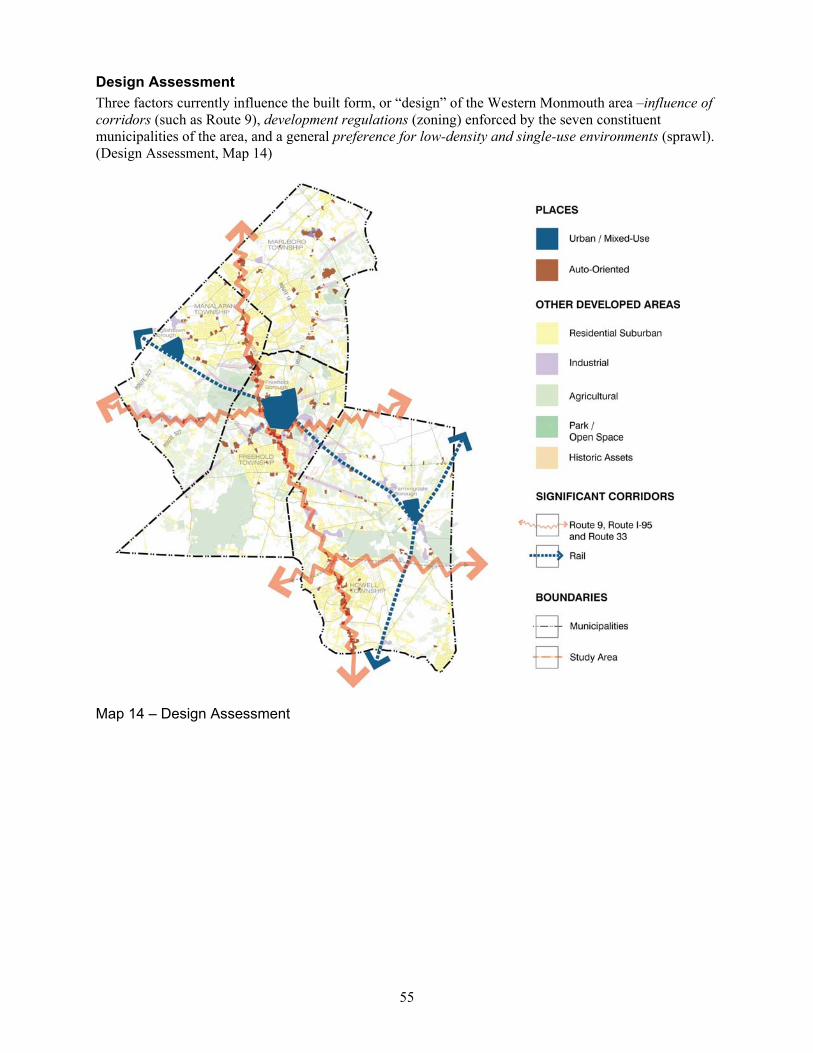
55
Design Assessment Three factors currently influence the built form, or “design” of the Western Monmouth area –influence of corridors (such as Route 9), development regulations (zoning) enforced by the seven constituent municipalities of the area, and a general preference for low-density and single-use environments (sprawl). (Design Assessment, Map 14)
Map 14 – Design Assessment
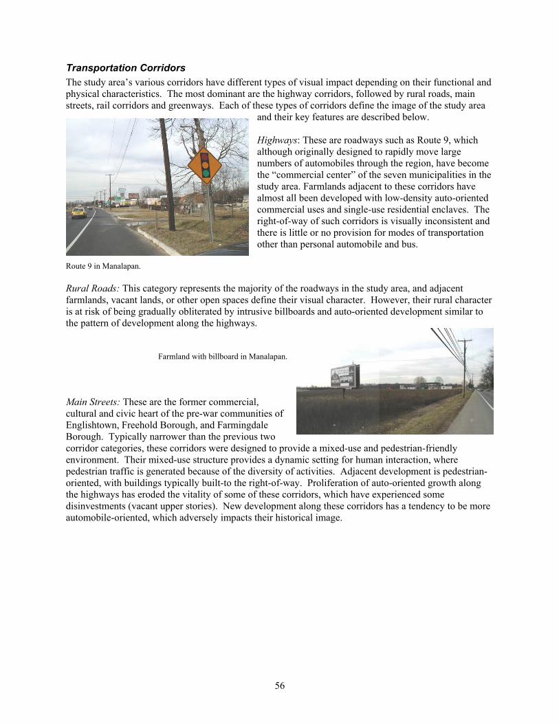
56
Transportation Corridors The study area’s various corridors have different types of visual impact depending on their functional and physical characteristics. The most dominant are the highway corridors, followed by rural roads, main streets, rail corridors and greenways. Each of these types of corridors define the image of the study area
and their key features are described below. Highways: These are roadways such as Route 9, which although originally designed to rapidly move large numbers of automobiles through the region, have become the “commercial center” of the seven municipalities in the study area. Farmlands adjacent to these corridors have almost all been developed with low-density auto-oriented commercial uses and single-use residential enclaves. The right-of-way of such corridors is visually inconsistent and there is little or no provision for modes of transportation other than personal automobile and bus.
Route 9 in Manalapan. Rural Roads: This category represents the majority of the roadways in the study area, and adjacent farmlands, vacant lands, or other open spaces define their visual character. However, their rural character is at risk of being gradually obliterated by intrusive billboards and auto-oriented development similar to the pattern of development along the highways.
Farmland with billboard in Manalapan. Main Streets: These are the former commercial, cultural and civic heart of the pre-war communities of Englishtown, Freehold Borough, and Farmingdale Borough. Typically narrower than the previous two corridor categories, these corridors were designed to provide a mixed-use and pedestrian-friendly environment. Their mixed-use structure provides a dynamic setting for human interaction, where pedestrian traffic is generated because of the diversity of activities. Adjacent development is pedestrian-oriented, with buildings typically built-to the right-of-way. Proliferation of auto-oriented growth along the highways has eroded the vitality of some of these corridors, which have experienced some disinvestments (vacant upper stories). New development along these corridors has a tendency to be more automobile-oriented, which adversely impacts their historical image.
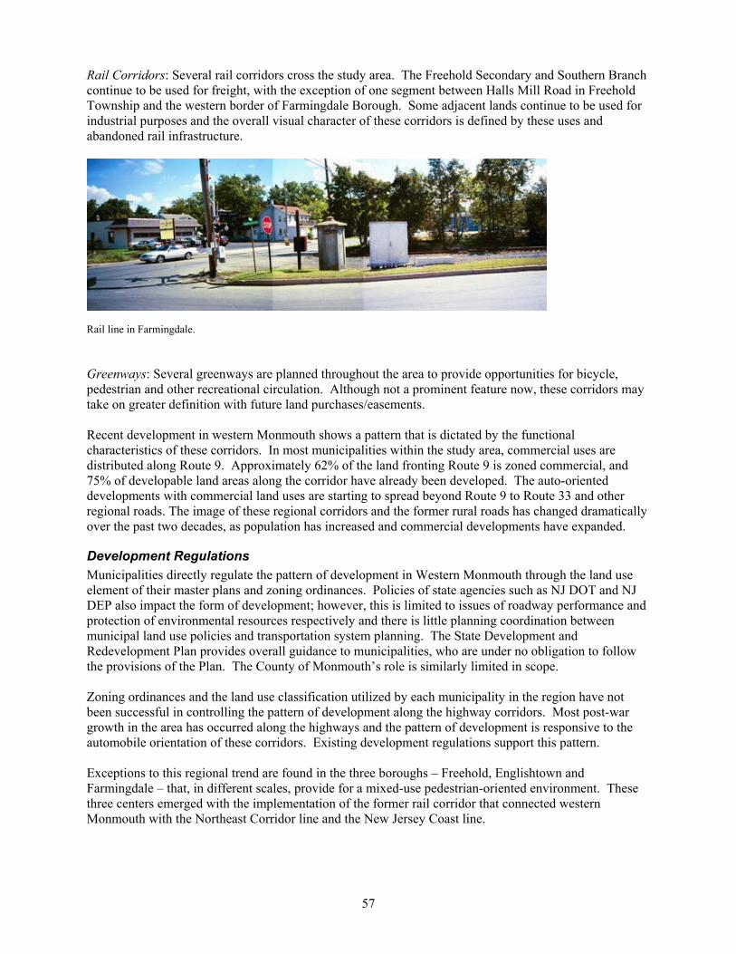
57
Rail Corridors: Several rail corridors cross the study area. The Freehold Secondary and Southern Branch continue to be used for freight, with the exception of one segment between Halls Mill Road in Freehold Township and the western border of Farmingdale Borough. Some adjacent lands continue to be used for industrial purposes and the overall visual character of these corridors is defined by these uses and abandoned rail infrastructure.
Rail line in Farmingdale. Greenways: Several greenways are planned throughout the area to provide opportunities for bicycle, pedestrian and other recreational circulation. Although not a prominent feature now, these corridors may take on greater definition with future land purchases/easements. Recent development in western Monmouth shows a pattern that is dictated by the functional characteristics of these corridors. In most municipalities within the study area, commercial uses are distributed along Route 9. Approximately 62% of the land fronting Route 9 is zoned commercial, and 75% of developable land areas along the corridor have already been developed. The auto-oriented developments with commercial land uses are starting to spread beyond Route 9 to Route 33 and other regional roads. The image of these regional corridors and the former rural roads has changed dramatically over the past two decades, as population has increased and commercial developments have expanded.
Development Regulations Municipalities directly regulate the pattern of development in Western Monmouth through the land use element of their master plans and zoning ordinances. Policies of state agencies such as NJ DOT and NJ DEP also impact the form of development; however, this is limited to issues of roadway performance and protection of environmental resources respectively and there is little planning coordination between municipal land use policies and transportation system planning. The State Development and Redevelopment Plan provides overall guidance to municipalities, who are under no obligation to follow the provisions of the Plan. The County of Monmouth’s role is similarly limited in scope. Zoning ordinances and the land use classification utilized by each municipality in the region have not been successful in controlling the pattern of development along the highway corridors. Most post-war growth in the area has occurred along the highways and the pattern of development is responsive to the automobile orientation of these corridors. Existing development regulations support this pattern. Exceptions to this regional trend are found in the three boroughs – Freehold, Englishtown and Farmingdale – that, in different scales, provide for a mixed-use pedestrian-oriented environment. These three centers emerged with the implementation of the former rail corridor that connected western Monmouth with the Northeast Corridor line and the New Jersey Coast line.

58
Development Patterns With the exception of the three pre-war settlements (Freehold Borough, Englishtown Borough, and Farmingdale Borough), the development pattern in Western Monmouth has emerged in response to strong citizen preferences for low-density and single-use environments. Two dominant patterns exist and trends indicate continued expansion of these patterns: Suburban Residential: Usually located adjacent to an extensive roadway system, these residential areas are characterized by a low intensity of development that occurs where developable land is available. Current development patterns in these areas are almost entirely dependent on the automobile for transportation. Scattered subdivisions and employment centers offer few points of community interaction. This development type extends sprawl, focusing on the same single-use development, in response to developer and market demand and local zoning requirements.
Freehold subdivision. Suburban Commercial Strip: Focused on serving suburban developments in the region, these corridors are dominated by the automobile. Characterized by large parking areas and linked to the residential zones by an extensive roadway system, these commercial strips frequently have considerable problems with congestion in peak-hours. The environment is unappealing because of congestion and lack of connections between adjacent developments along the same corridor, which requires users to reenter the corridor even for short local trips. There are also no pedestrian connections among different commercial developments; users have to drive from one destination to another even if they are within walking distance. The factors that influence development will likely result in continuance of the existing development trends unless proactive planning is initiated. The regional plan process encourages a new approach in keeping with smart growth concepts through an examination of design alternatives for each municipality. These choices will determine the future vision for the region.

59
ISSUES
Planning Planning issues are integrally linked to the other issues of the region. For example, future development patterns and land use controls greatly affect transportation conditions, especially on Route 9. Alternative strategies can help mitigate future transportation problems on the corridor. Mixed-use transit oriented development centers can assist in reducing trips on Route 9. Design guidelines that require pedestrian connections to transit and retail centers can also help reduce the number of vehicular trips. Planning is also essential to protecting important natural resources. The preservation of farmland and open space are key goals for the region municipalities. Current planning should consider addressing these goals even more aggressively, and balancing them with alternative land use options. As part of the Western Monmouth Region Plan, the State Plan endorsement process will require that existing and proposed centers and other places be identified and that the proposed land use, zoning and sewer infrastructure be consistent with the proposed plan.
Land Use One of the greatest issues of concern in the study area is the relentless suburban sprawl that is advancing across the region. The Brookings Institution defines an area as “sprawling” when land is urbanized at a faster rate than population growth. That condition applies to the Western Monmouth region. Through 2020, the population is projected to increase by 22 percent, and the amount of urbanized land by at least 38 percent, or close to double the population growth rate. The population growth in the study area was two-and-one-half times the statewide increase in the 1990s, and four times the statewide increase in the 1980s. In response to this growth, and in an effort to preserve their rural character, all townships have downzoned vast areas within residential districts. Unfortunately, this effort has merely served to increase the rate of sprawl; the rate at which land is urbanized typically increases in proportion to the size of residential lots. Further, the 1 to 3 acre zones that cover much of the study area do not preserve the rural character of the area. These lots are too small to preserve wooded areas, and certainly too small to preserve viable agricultural lands. There are two basic possibilities – with numerous variations on each – for dealing with this issue:
1) In certain areas, increase the size of lots to as many as 10 acres, in order that the land is less economically feasible to develop and to preserve farmlands; and
2) In other areas, preferably in selected nodes or centers, increase the density of residential districts. These nodes or centers should ideally be associated with community facilities, such as schools, government facilities (i.e., post offices, libraries), retail centers, or transportation centers. This land will be developed at cheaper infrastructure costs for sewer and roadways; will make it possible for their residents to walk to desired uses; and will be more efficient in use of land.
The three boroughs in the study area have different issues than the townships. They are not located along Route 9 (Freehold Borough is, but only tangentially) and they are not affected by sprawl. Their greatest concern is likely to be downtown and neighborhood revitalization. All three are attractive communities, but have lower median incomes than the county and state average, and would benefit from planning to maintain their continued viability.
Farmland Preservation Farmland preservation is perhaps the greatest environmental issue in the study area. In the current budgetary atmosphere, with cuts made to the state farmland preservation funding by Governor McGreevey, the issue has taken on new urgency. Farmland easements/acquisition will remain the most certain means of preserving farmland, but municipalities must be encouraged to implement other methods, such as cluster or transfer of development rights.
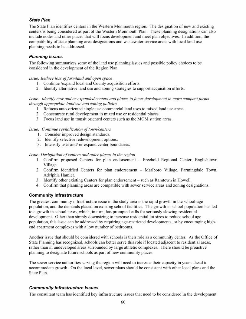
60
State Plan The State Plan identifies centers in the Western Monmouth region. The designation of new and existing centers is being considered as part of the Western Monmouth Plan. These planning designations can also include nodes and other places that will focus development and meet plan objectives. In addition, the compatibility of state planning area designations and wastewater service areas with local land use planning needs to be addressed.
Planning Issues The following summarizes some of the land use planning issues and possible policy choices to be considered in the development of the Region Plan. Issue: Reduce loss of farmland and open space
1. Continue /expand local and County acquisition efforts. 2. Identify alternative land use and zoning strategies to support acquisition efforts.
Issue: Identify new and or expanded centers and places to focus development in more compact forms through appropriate land use and zoning policies
1. Refocus auto-oriented single use commercial land uses to mixed land use areas. 2. Concentrate rural development in mixed use or residential places. 3. Focus land use in transit oriented centers such as the MOM station areas.
Issue: Continue revitalization of town/centers 1. Consider improved design standards. 2. Identify selective redevelopment options. 3. Intensify uses and/ or expand center boundaries.
Issue: Designation of centers and other places in the region
1. Confirm proposed Centers for plan endorsement – Freehold Regional Center, Englishtown Village.
2. Confirm identified Centers for plan endorsement – Marlboro Village, Farmingdale Town, Adelphia Hamlet.
3. Identify other existing Centers for plan endorsement – such as Ramtown in Howell. 4. Confirm that planning areas are compatible with sewer service areas and zoning designations.
Community Infrastructure The greatest community infrastructure issue in the study area is the rapid growth in the school-age population, and the demands placed on existing school facilities. The growth in school population has led to a growth in school taxes, which, in turn, has prompted calls for seriously slowing residential development. Other than simply downsizing to increase residential lot sizes to reduce school age population, this issue can be addressed by requiring age-restricted developments, or by encouraging high-end apartment complexes with a low number of bedrooms. Another issue that should be considered with schools is their role as a community center. As the Office of State Planning has recognized, schools can better serve this role if located adjacent to residential areas, rather than in undeveloped areas surrounded by large athletic complexes. There should be proactive planning to designate future schools as part of new community places. The sewer service authorities serving the region will need to increase their capacity in years ahead to accommodate growth. On the local level, sewer plans should be consistent with other local plans and the State Plan.
Community Infrastructure Issues The consultant team has identified key infrastructure issues that need to be considered in the development
61
of the Region Plan. Issue: Provide for future school sites to accommodate expanding school age population
1. Develop schools sites as community centers.
Issue: Address land use and zoning changes to reduce future school age population 1. Consider downzoning to increased lot sizes to reduce population. 2. Consider age-restricted housing options. 3. Consider housing geared to ‘empty nesters’ with no or limited children.
Issue: Plan wastewater service areas to focus future growth in appropriate locations
1. Achieve consistency of wastewater service areas with local plans and the State Policy Plan.
Transportation There are numerous transportation issues to address. As documented in the Transportation section, Route 9 is unfriendly to pedestrian activity, as are many of the arterial and collector roadways in the study area. These roadways are even less amenable to bicycling activity. There is a strong need for more sidewalks in the study area, and for pedestrian linkages between adjacent commercial developments, as well as between adjacent commercial and residential developments. Of course, one of the most certain methods of increasing pedestrian activity is by placing different attractions within walking distance of each other. Both pedestrians and motor vehicles would benefit from an access management policy. By reducing the number of driveways along Route 9, and encouraging linked driveways and parking lots between adjacent commercial developments, pedestrians would have more mobility along the corridor and traffic flow and safety would be improved. Transit use, which removes many trips from Route 9, should continue to be encouraged. The expansion of existing park and ride lots, and the creation of new lots, should be investigated. Development patterns on Route 33 that make transit service more feasible would be desirable; there is an inverse relationship between the financial feasibility of transit services and low density land development. More extensive shuttle service from the study area municipalities to the Matawan train station should be investigated. Finally, the location of proposed MOM stations should be taken into consideration when identifying centers within the study area. Ensuring acceptable traffic conditions along the Route 9 corridor will be difficult, given the projected increases in traffic volumes through the year 2020. Even widening Route 9 from four to six lanes will not result in acceptable levels of service at all intersections; a series of costly grade-separated interchanges would also be required. The effects of current land use policy on transportation conditions will thus need to be examined.
Transportation Issues The following presents key transportation issues and possible strategies to address these issues. The choices presented below can be “mixed and matched” to great extent to address the issues. For example, it is possible that every option discussed under “Transit Improvements” could be implemented, although establishing priorities may well be necessary. Issue: Transit improvements
1. Construct additional park and ride lots on Route 9. 2. Construct park and ride lots on Route 33 with shuttle service. 3. Reduce bus headways and increase bus route coverage. 4. Provide shuttle service to Matawan train station. 5. Construct /improve pedestrian links to park and ride facilities.

62
6. Support high density residential and mixed use development in the Corridor to create transit hubs. 7. Encourage transit oriented development (TOD’s) around proposed M-O-M stations and park and
ride lots. Issue: Sidewalk improvements
1. In existing urbanized areas, install sidewalks to serve medium to high-density residential developments and retail centers.
2. Install sidewalks to serve schools and community facilities serving children, elderly and less mobile populations.
3. Provide sidewalk connections to park and ride lots and transit stops. 4. Encourage high density mixed use areas to promote pedestrian trips.
Issue: Access management including pedestrian linkages
1. Require vehicular and pedestrian linkages between adjoining retail developments. 2. Require pedestrian linkages between retail and adjoining residential developments. 3. Prepare Access Management Plan for Route 9.
Issue: Pedestrian facilities on Route 9
1. Provide pedestrian signals. 2. Provide pedestrian crosswalks. 3. Install missing sidewalk linkages.
Issue: Route 9 transportation improvements
1. Construct no Route improvements (except currently planned improvements). 2. Improve existing interchange/intersections only. 3. Expand Route 9 to six lanes. 4. Provide new grade separated interchanges from Route 33 north. 5. Construct service roads with grade separated interchanges. 6. Downzone remaining vacant lands to reduce future traffic. 7. Promote mixed use developments to reduce trips. 8. In conjunction with downsizing elsewhere, promote high density and age restricted residential
development units to reduce trips. 9. Aggressively pursue open space and farmland preservation to reduce future traffic.
Design The overall objective of this study is to prepare a plan for implementation of the smart growth concept, which is based on the following guiding principles:
• New growth should be leveraged to improve the existing community. • Investments should be made to preserve/restore the vitality of existing urban areas and older
suburbs. • Farmland, open space and other environmental amenities should be preserved. • Development regulations should not promote a "one-size-fits-all" solution.
As noted in the design assessment section, factors that currently influence development patterns in Western Monmouth will likely result in continuance of existing development trends towards sprawl (low-density, single-use and automobile-oriented development). This trend is not consistent with the principles of the smart growth concept. Consequently, the consultant team has identified key issues that are likely to inform the pattern of development or “design” of the Western Monmouth area. Associated with each issue is a range of choices. The choices represent alternative strategies that can be employed by the County and municipalities to implement the smart growth concept.
Design Issues Issue: Location and pattern of future growth
1. Intensify Route 9 and Route 33 corridors – concentrate new development along these corridors.

63
2. Focus new development in new transit-oriented-developments along the proposed M-O-M transit line.
3. Concentrate new development in the existing urban/mixed-use centers. 4. Concentrate more development in nodes along Route 9 and Route 33, around schools or other
community facilities, and in village centers. Issue: Functional and visual consistency of the Route 9 corridor
1. Enforce single image for the corridor, with county-wide design standards. 2. Vary design of the right-of-way and adjacent development with elements that are specific to each
municipality. 3. Group development along the corridor into clusters, each of which would have a unique visual
identify. Issue: Impact of existing urban and mixed-use places (that are already consistent with the principles of smart growth)
1. Expand the existing places, thereby increasing the areas within Western Monmouth that are consistent with the principles of smart growth.
2. Increase the density of existing places, thereby increasing their relative population and 3. Consequently reducing automobile-dependency in Western Monmouth. 4. Create new places either along the highway corridors or along the proposed M-O-M line.
Issue: Preservation of rural roads
1. Preserve all remaining farmlands permanently. 2. Preserve remaining farmlands but allow concentrated development nodes at major intersections. 3. Protect corridor image through scenic roads designation and protection of adjacent lands only.