
Roundtable on Sustainable Palm Oil SEIA HCV Assessment Summary Report_SGSOG... · Initial work was...
17
RSPO Roundtable on Sustainable Palm Oil SGSOG_NPP Notification _ Nov 2011 1 RSPO NEW Planting Procedures Summary Report of SEIA and HCV Assessment SG Sustainable Oils Limited, Brewaniase, Nkwanta South District of the Volta Region, Republic of Ghana. 1.0 Executive Summary SG Sustainable Oils Ghana Ltd (SGSOG), a wholly owned subsidiary of Herakles Farms, is developing approximately 3,715 hectares of sustainable oil palm plantations in Republic of Ghana. SGSOG was incorporated within Ghana in 2008. SGSOG is a subsidiary of Herakles Farms, which was previously known as SG Sustainable Oils (SGSO). SGSO has been a member of RSPO since March 2008, and recently an application by the parent company to RSPO for its membership to be recognized under Herakles Farms has been approved. The company’s palm oil estate is located in the Volta Region, near the village of Brewaniase, Nkwanta South District, Republic of Ghana. This document outlines the Social and Environmental Impact Assessment (SEIA) and High Conservation Value (HCV) Assessment process and documentation for SGSOG’s oil palm development summarized by assessors from SAL Consult Limited and Ghana Wildlife Society. A comprehensive and participatory independent SEIA and HCV Assessment which included internal and external stakeholders were completed. The results incorporated into planning, management and operational ongoing work. The independent assessments recognised the following: There was no primary forest in the location. All area required to maintain or enhance one or more HCV. There was no peat soil identified. All peoples’ private land. Abbreviations Used EIA Environmental Impact Assessment EPA Environmental Protection Agency HCV High Conservation Value IUCN International Union for Conservation of Nature RSPO Roundtable on Sustainable Palm Oil SGSOG SG Sustainable Oils Ghana SEIA Social and Environmental Impact Assessment SIA Social Impact Assessment 2.0 Scope of SEIA and HCV Assessment SG Sustainable Oils Ghana Ltd (SGSOG) is a wholly owned subsidiary of Herakles Farms. SGSOG was incorporated within Ghana in 2008. SGSOG is a RSPO member (№: 100500800000) developing oil palm plantation at Brewaniase, Nkwanta South District of the Volta Region in Republic of Ghana. General Data of the Company Company Name : SG Sustainable Oils Ghana Ltd (SGSOG) Deed of Incorporation : Certificate of Incorporation dated 7 October 2008. Business license : Certificate to commence business dated 10 November 2008 in compliance with sec. 27 and 28 of the Companies code, 1963. Director : Carmine Farnan Company Address : Brewaniase, Nkwanta South District of the Volta Region, Box 0S 514,OSU-ACCRA, Accra, Republic of Ghana.
Transcript of Roundtable on Sustainable Palm Oil SEIA HCV Assessment Summary Report_SGSOG... · Initial work was...

RSPO
Roundtable on Sustainable Palm Oil
SGSOG_NPP Notification _ Nov 2011 1
RSPO NEW Planting Procedures Summary Report of SEIA and HCV Assessment
SG Sustainable Oils Limited,
Brewaniase, Nkwanta South District of the Volta Region, Republic of Ghana.
1.0 Executive Summary
SG Sustainable Oils Ghana Ltd (SGSOG), a wholly owned subsidiary of Herakles Farms, is
developing approximately 3,715 hectares of sustainable oil palm plantations in Republic of Ghana.
SGSOG was incorporated within Ghana in 2008. SGSOG is a subsidiary of Herakles Farms, which
was previously known as SG Sustainable Oils (SGSO). SGSO has been a member of RSPO since
March 2008, and recently an application by the parent company to RSPO for its membership to be
recognized under Herakles Farms has been approved. The company’s palm oil estate is located in the
Volta Region, near the village of Brewaniase, Nkwanta South District, Republic of Ghana. This
document outlines the Social and Environmental Impact Assessment (SEIA) and High Conservation
Value (HCV) Assessment process and documentation for SGSOG’s oil palm development
summarized by assessors from SAL Consult Limited and Ghana Wildlife Society.
A comprehensive and participatory independent SEIA and HCV Assessment which included internal
and external stakeholders were completed. The results incorporated into planning, management and
operational ongoing work. The independent assessments recognised the following:
There was no primary forest in the location.
All area required to maintain or enhance one or more HCV.
There was no peat soil identified.
All peoples’ private land.
Abbreviations Used
EIA Environmental Impact Assessment
EPA Environmental Protection Agency
HCV High Conservation Value
IUCN International Union for Conservation of Nature
RSPO Roundtable on Sustainable Palm Oil
SGSOG SG Sustainable Oils Ghana
SEIA Social and Environmental Impact Assessment
SIA Social Impact Assessment
2.0 Scope of SEIA and HCV Assessment
SG Sustainable Oils Ghana Ltd (SGSOG) is a wholly owned subsidiary of Herakles Farms. SGSOG
was incorporated within Ghana in 2008. SGSOG is a RSPO member (№: 100500800000) developing
oil palm plantation at Brewaniase, Nkwanta South District of the Volta Region in Republic of Ghana.
General Data of the Company
Company Name : SG Sustainable Oils Ghana Ltd (SGSOG)
Deed of Incorporation : Certificate of Incorporation dated 7 October 2008.
Business license : Certificate to commence business dated 10 November 2008
in compliance with sec. 27 and 28 of the Companies code,
1963.
Director : Carmine Farnan
Company Address : Brewaniase, Nkwanta South District of the Volta Region,
Box 0S 514,OSU-ACCRA, Accra, Republic of Ghana.

RSPO
Roundtable on Sustainable Palm Oil
SGSOG_NPP Notification _ Nov 2011 2
Type of business : Oil Palm Plantation and Palm Oil Mill opearation.
Status of business land : Leased Land dated 11 January 2009 for a period of 50 years
with provision to extend for another 25 years.
Location Size : 3,715 ha.
Contact person : Carmine Farnan ([email protected])
Geographical Location : Brewaniase, Nkwanta South District of the Volta Region,
Republic of Ghana.
GPS Reference : 0° 35’ 0” E and 7° 56’ 0”
Location maps – both at landscape level and property level
Location maps are prepared and presented in the SEIA and HCV assessment reports to include all the
assessment findings. Location maps showing the project location and boundary are in Figure 1, 2 and 3
below. The SEIA and HCV summary reports includes additional maps showing the topography, landscape,
HCV and land use. HCV maps prepared to include areas set aside for buffer and riparian reserve, roads,
housing, peoples’ private land.
Figure 1. Geography location of SGSOG oil palm plantation in Republic of Ghana.

RSPO
Roundtable on Sustainable Palm Oil
SGSOG_NPP Notification _ Nov 2011 3
Figure 2: SOSOG location in Nkwanta South District in Republic of Ghana.
Figure 3. SGSOG boundary with GPS reference.
RSPO
Roundtable on Sustainable Palm Oil
SGSOG_NPP Notification _ Nov 2011 4
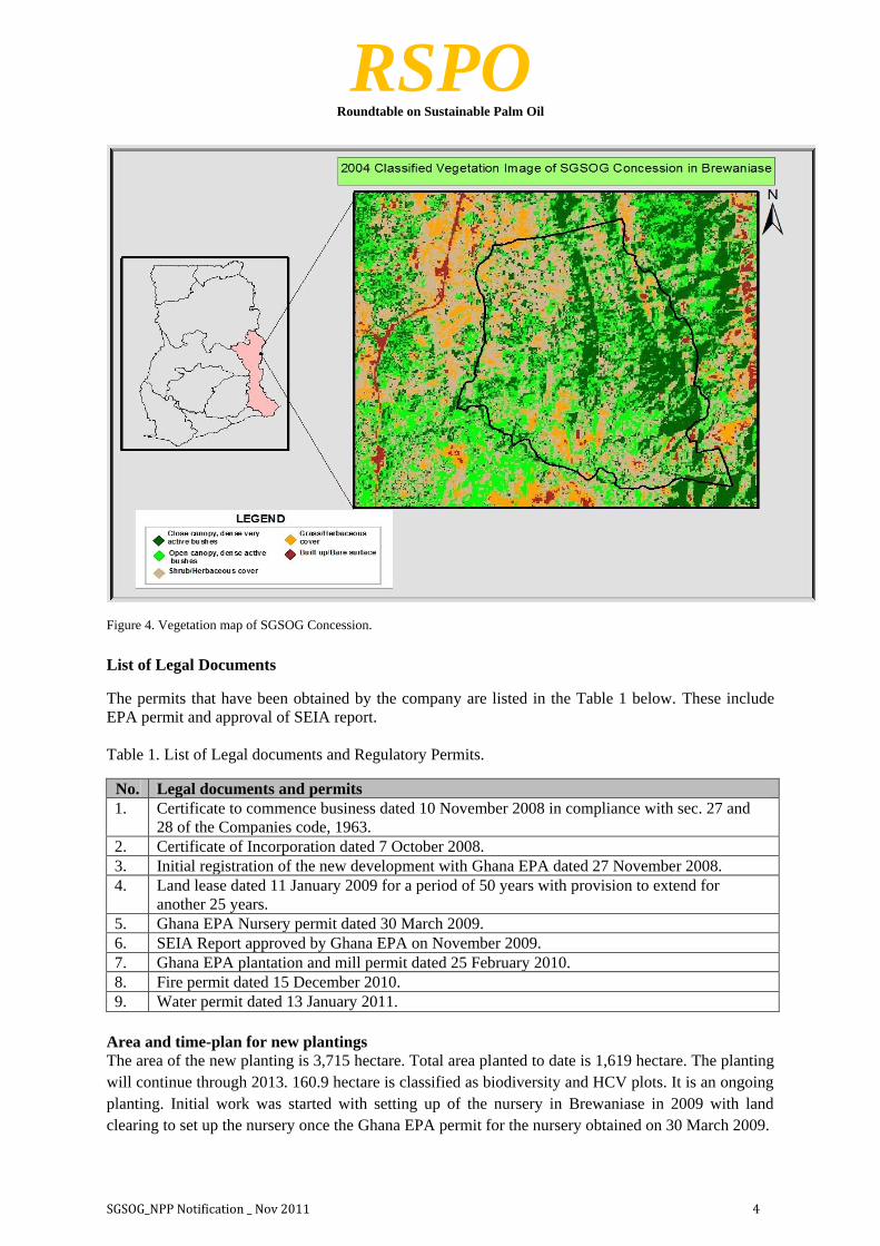
Figure 4. Vegetation map of SGSOG Concession.
List of Legal Documents
The permits that have been obtained by the company are listed in the Table 1 below. These include
EPA permit and approval of SEIA report.
Table 1. List of Legal documents and Regulatory Permits.
No. Legal documents and permits
1. Certificate to commence business dated 10 November 2008 in compliance with sec. 27 and
28 of the Companies code, 1963.
2. Certificate of Incorporation dated 7 October 2008.
3. Initial registration of the new development with Ghana EPA dated 27 November 2008.
4. Land lease dated 11 January 2009 for a period of 50 years with provision to extend for
another 25 years.
5. Ghana EPA Nursery permit dated 30 March 2009.
6. SEIA Report approved by Ghana EPA on November 2009.
7. Ghana EPA plantation and mill permit dated 25 February 2010.
8. Fire permit dated 15 December 2010.
9. Water permit dated 13 January 2011.
Area and time-plan for new plantings
The area of the new planting is 3,715 hectare. Total area planted to date is 1,619 hectare. The planting
will continue through 2013. 160.9 hectare is classified as biodiversity and HCV plots. It is an ongoing
planting. Initial work was started with setting up of the nursery in Brewaniase in 2009 with land
clearing to set up the nursery once the Ghana EPA permit for the nursery obtained on 30 March 2009.
RSPO
Roundtable on Sustainable Palm Oil
SGSOG_NPP Notification _ Nov 2011 5
3.0 Assessment Process and Procedures
3.1 SEI Assessment
Plantation developments in Ghana require the completion of a Social and Environmental Impact
Assessment (SEIA), which is approved by the Ghana Environmental Protection Agency (EPA). The
SEIA for the Brewaniase site included 3,715 hectares for plantation development and a proposed 25
tonnes/hour Palm Oil Mill. The scope of the SEIA included the establishment, operations and
decommissioning of the plantation and mill. The SEIA was developed by SAL Consult Ltd. Ghana
EPA approved the SEIA in November 2009.
Assessors and their credentials:
The SEIA was completed by S.A. Larmine as a Principle Consultant from SAL Consult Ltd. He was
the team leader and assisted by the following assessors throughout the SEI assessment:
Social Impact Assessment on the ground was carried out as bellows:-
The Social and Environmental Impact Assessment (SEIA) covered the whole lifecycle of plantation
and mill development. It involved environmental sampling, aquatic studies, terrestrial studies, land
use studies, and socio-economic studies. The assessment was based on field inspections and surveys,
consultations with stakeholders and desktop literature studies. The assessment provided the basis for
an environmental monitoring plan. The assessment was completed by SAL Consult Ltd.
The approach adopted for the study included:
Reconnaissance survey of the proposed project area
Field Study (Aquatic, Terrestrial biodiversity and physical, Land use and Socio-economic studies)
Consultations with relevant stakeholders
Review of available literature
Name Position Qualification Contribution to Report
J. Adomako Associate Consultant,
Terrestrial Biologist
Ph.D. (Ecology),
University of Ghana,
Legon.
Flora and Fauna Studies
J. Amakye Associate Consultant,
Aquatic Biologist
Ph.D. (Biological
Sciences), K.N.U.S.T.,
Kumasi
Aquatic Studies
Regina Aikins
Consultant,
Biophysical
Environment, Socio-
economic Environment
MSc (Environmental
Resources
Management),
K.N.U.S.T., Kumasi
-Consultations
-Baseline Studies
-Project document review
-Drafting of Report
R.Y. Amoako
Senior Consultant,
Biophysical
Environment, Socio-
economic Environment
MPhil (Environmental
Science), University of
Ghana, Legon
-Consultations
-Air Quality/Noise Level
Assessment
-Water Quality Assessment
E. K. Acquah
Senior Consultant,
Resettlement related
issues
MSc (Environmental
Policy), University of
Hull, UK
-Consultations
-Baseline Studies
-Resettlement issues
N.Y. Otu-Ansah Consultant, Socio-
economic Environment
MPhil (Environmental
Science), University of
Ghana, Legon
-Consultations
-Baseline Studies
J. Payne Consultant, Hydrology
and Water Resources
MSc (Water Supply &
Environmental
Sanitation),
K.N.U.S.T., Kumasi
-Water Resources
-Baseline Studies
-Project document review

RSPO
Roundtable on Sustainable Palm Oil
SGSOG_NPP Notification _ Nov 2011 6
Stakeholder consultation
The SGSOG concession is made up of family-owned land and involves stakeholders from
Breawaniase, Dodo Tamale, Abuburuwa and Fankyenko. The concession land is owned by total of
seventeen families. In January of 2009, the land owners and the company entered into a long-term
lease agreement which was subsequently endorsed and recognised by the government of Ghana. The
terms of the lease are for 50 years with provisions made for further extensions of 25 years.
The social consultation process, which began in January 2008, was lead by SAL Consult Ltd., a
Ghana-based expert on environmental and social project support, with significant inputs from Dan
Beringer (Consultant for Herakles Farms) other management staff, and local village representatives.
Compensation for affected farmers was based on the company’s “Policy Statement for Compensation
and Resettlement for Persons Affected by SGSOG Farming Activities”. Further to that “A
Resettlement Action Plan”, provides a background to the communities affected, the compensation
process and action plan. The purpose of engaging local communities and project-affected-persons on the
resettlement/compensation process is to ensure that local community members and project affected
persons and other interested parties are provided with clear information about the Project, are given
the opportunity to express their views and concerns, negotiate on resettlement and compensation
issues, and make suggestions as to how design and implementation of the Project might reduce
negative social impacts.
Community involvement is a key social risk management tool that enables parties’ interests, concerns
and areas of potential conflict to be identified and resolved before they lead to disruption in the
operation of the project and/or loss of goodwill amongst the host community.
SGSOG paid for an attorney to provide legal council to the 17 landowner families to assure that a free
and fair agreement was reached between the parties. The Land Commission ensured that there were
no other claims on the land, performed regulatory checks, and fully registered the lease agreement.
The final land lease was also acknowledged and witnessed local chiefs. (A scanned copy of the signed
lease was available for verification).
All relevant stakeholders were engaged during the consultation process consisting communities,
landowners, farmers, opinion leaders, local political authorities, and government agency regulators.
The consultation process was conducted via various one-on-one meetings, focus group discussions
and key person interviews. Details of the consultation process are in the EIA report under Annex 3:
Stakeholder Engagement, Annex 4: Consultations and Annex 4a: Stakeholder and Compensations.
This documents made available during the verification.
Public Meetings at Local Communities:
Table 1. Summary of stakeholder consultation schedule
Date Meeting Number Attended
3/04/2010 Crops compensation 19
5/04/2010 Landowners Association (LOA) 25
19/05/2010 LOA / farmers 65
25/05/2010 Farmers 50
28/05/200 Compensation Committee 19
3/08/2010 Land Valuation Board 3
22/10/2010 Land Valuation Board 4

RSPO
Roundtable on Sustainable Palm Oil
SGSOG_NPP Notification _ Nov 2011 7
Table 2. List of Stakeholders Consulted in Resettlement & Compensation Process
List of Stakeholders consulted
Chief/Elders of Abrubruwa;
Paramount Chief and elders of Ntruboman;
Land Owners;
Settler communities on the concession;
Nkwanta District Assembly;
Ghana EPA Ho Regional Office;
Land Valuation Board, Ho; and
Officials of SG Sustainable Oils Ghana Limited
Forestry Services Division of Forestry Commission, Nkwanta Office
Wildlife Division of Forestry Commission, Nkwanta Office
Water Resources Commission
Ministry of Food and Agriculture, Nkwanta Office
Nkwanta South District Assembly
Abrubruwa Assembly members
Brewaniase Assemblyman
List of Legal, regulatory and other guidance referenced.
This environmental and social impact assessment, commissioned by SGSOG is in compliance with
the Environmental Protection Agency (EPA) Act 490 of 1994 and Environmental Assessment
Regulation Act of 1999 (LI 1652), a prerequisite for obtaining Environmental Permit (EP) for the
implementation of the project. The relevant Ghanaian laws and regulations applicable to the
implementation of the project referred include:
Ghana Investment Promotion Centre Act, 1994, Act 478;
Environmental Protection Agency Act, 1994, Act 490;
Environmental Assessment Regulations, 1999, LI 1652;
Environmental Assessment Regulations (Amendment), 2002, LI 1703;
Water Resources Commission Act, 1996, Act 522;
Water Use Regulations, 2001, LI 1692;
Local Government Act 1993, Act 462;
Factories, Offices and Shops Act 1970, Act 328;
The New Labour Act 2003, Act 651;
Fire Precautions (Premises) Regulations 2003, LI 1724;
Food and Drugs Law 1992, PNDCL 305B;
Constitution of the Republic of Ghana 1992;
State Lands Act, 1962 Act 125;
Workmen’s Compensation Law, 1987;
Forestry Commission Act 1999 (Act 571);
Wildlife Conservation Regulations 1971, LI 685;
Administration of Lands Act, 1962, Act 123;
Pesticides Control and Management Act, 1996, Act 528;
National Effluent Quality Discharge Guidelines;
National Ambient Air Quality Guidelines;
National Ambient Noise Level Guidelines;
Immigration Act 2000, Act 573
HCV interpretation toolkit for Ghana (Proforest, 2006)
National Wildlife Conservation Regulation
IUCN Red List of threatened animals (2008)
The 1962 State Lands Act

RSPO
Roundtable on Sustainable Palm Oil
SGSOG_NPP Notification _ Nov 2011 8
3.2 HCV Assessment
Assessors and their credentials
The HCV assessment was completed by Mr. Augustus Asamoah of the Ghana Wildlife Society, an
RSPO approved HCV assessment Team leader with specialised in Biodiversity, Hydrology/Soil and
Social. He obtained PhD in Biodiversity Studies, Department of Animal Biology and Conservation
Science, University of Ghana, Legon. He is a conservation ecologist with expertise in environmental
research and environmental resources management. His specific expertise are in natural resources
management, field ornithology, habitat appraisal, conservation planning and high conservation value
assessment, design and implementation of baseline biodiversity and environmental studies. With over
twelve years functional professional experience in conservation ecology and natural resources
management, he is currently coordinate and lead all the biodiversity conservation research programs
of Ghana Wildlife Society (GWS).
He was assisted by a team of appropriately qualified and experienced team members. They are
Nathaniel Annorbah and Reuben Ottou. Nathaniel Annorbah is a Conservation Biologist with M. Phil.
(Biodiversity Studies option) and B.Sc. Zoology degrees from the University of Ghana. He is also
hold a Certificate in Conservation Science from the Acopian Center for Conservation Learning, USA.
He have extensive knowledge and experience in undertaking faunal, especially, avifaunal surveys
having worked in all of Ghana’s habitat types ranging from the coastal zone through the forest
ecosystems to the savannas of northern Ghana and southern Burkina Faso. He led and taken part in
various studies both while working with the Zoological Society of London Wildlife Wood Project –
Ghana and currently the Ghana Wildlife Society. Reuben Ottou holds M.Sc in Environmental and
International Development with over eight years experience in Community Based Natural Resources
Management, where he developed key skills in participatory natural resources management and rural
development. His expertise include local capacity building in participatory natural resources
management, management of Integrated Conservation and Development Projects, protected Area
Management Planning, networking and building partnerships for conservation.
Assessment Methods
HCV Identifying Methods.
The High Conservation Value Assessment (HCVA) entailed a systematic evaluation of the
conservation value of the ecological, biodiversity and cultural elements at the proposed concession for
oil palm plantation using the Ghana national HCV interpretation toolkit (Proforest, 2006). The
assessment included field surveys, consultation with local communities and desktop studies. The
assessment also referred to the detailed studies carried out during the SEIA. The assessment made
appropriate recommendations to safeguard the ecological, biodiversity and cultural entities of high
conservation value identified on the concession. The assessment was completed by Augustus
Asamoah of the Ghana Wildlife Society, an RSPO-approved HCV Lead Assessor.
4.0 Summary of Assessment Findings
4.1 Summary of SEI Assessment
Summary of key findings in respect of socio-economic impacts to country, region and local
communities.
The SGSOG project is located at Brewaniase in the Nkwanta South District of the Volta Region. The
District covers a land area of 4,530km2, which represents about 22.02% of the total land area of the
Volta Region, which is about 20,570km2. The land use on the proposed site is basically fallow land,
bushy land, crop farms and farm houses (hamlets).
Climate
The District is characterized by a tropical climate with dry and humid weather conditions. The
extreme annual rainfalls range between 922mm to 1874 mm. The mean annual maximum

RSPO
Roundtable on Sustainable Palm Oil
SGSOG_NPP Notification _ Nov 2011 9
temperatures range between 24oC to 39oC, while the mean annual minimum temperatures range
between 11oC to 26oC.
Geography
The relief of the area is classified as mountainous southern portion lying along the eastern border with
the Republic of Togo and the undulating northern part with altitudes between 100m to 200m above
sea level. There are three types of vegetation in the project area namely; semi-deciduous forest zones
(covering about 30%), savanna woodland (covering about 50%), and the grassland savanna (covering
about 20%). The original vegetative cover has been reduced to secondary forests due to logging,
farming and cutting of fuel wood and charcoal production.
Geology & Soils
The area is underlain by the Voltaian, the Buem Volcanic formation and the Togo series. The
Voltaian, which is mainly shale and mudstone beds and sandy pebbly beds occupy the eastwards of
the Volta Lake and takes about a quarter of the District. The Togo series consist of quartzites,
phyllites, sandstone, shale, schist and sillicted. Limestone is found on the eastern border forming the
Buem - Togo ranges. The Buem - Volcanic formation consisting of Basaltic, Andesitic and Trachytic
lava occupies about two-thirds of the District. Soils found in the area are laterite and the forest
Ochrosols and Oxysols mostly found in the forest zone. There are no peat areas found onsite.
Water Resources
The main rivers that drain the area include the Oti River, which covers about 1% of the surface area of
the District, the Kpassa, Sabu, Bonakye and Chai Rivers. The proposed site is drained by a number of
streams including the Dibem, Tomgbah and the Kpafia Streams which all flow into the Asukokoo
river.
The Asukokoo River, which is a perennial, lies to the southern border of the project. It is proposed
that water may be abstracted from the Asukokoo and also groundwater, for the operations of the
plantation. It has been observed from the ten year period that minimum monthly flow is about
5.13m³/s. About 86m³/day of water will be required to establish the nursery while the mill itself will
use about 150m³/day for fruit processing. Abstraction amounts will vary with the wet and dry
seasons and will be confirmed from interactions with the Water Resources Commission, who is
mandated to manage the country’s water resources. SGSOG will ensure that abstraction from
boreholes is set at sustainable level in order not to adversely affect other groundwater users within the
catchment.
Aquatic Biology
The two sites selected for the study were upstream and downstream of the proposed location of the
Mill showed that the Asukokoo River is of good quality. Anabaena sp. a blue-green algal species that
is indicative of polluted waters was absent. River Asukokoo lacked zooplankton belonging to the
Micro Crustacea. The zooplankton encountered was the rotifer Synchaeta. Nine species of fish were
recorded during the study. None of the fish species recorded in the river is listed on the IUCN Red
List of threatened species.
Terrestrial Biodiversity
The proposed project area falls within the dry semi-deciduous vegetation zone, but the existing
vegetation on the proposed project site is a mosaic of secondary forest with open and discontinuous
canopy in most places, gallery forest along the river banks, savanna woodland, fallow land and
patches Tectona grandis, Gmelina arborea and Sena siame plantations. Flora study recorded a total of
80 species from 72 genera and 41 families. The plants recorded are predominantly green star species
with few pink and red star species. None of the flora species recorded in the study is of any global
conservation significance. Disturbances from logging, farming as well as wild fire have led to the
replacement of most of the original dry forest vegetation with transition woodland vegetation. The
habitat of the proposed project area is generally degraded.

RSPO
Roundtable on Sustainable Palm Oil
SGSOG_NPP Notification _ Nov 2011 10
Results of fauna study showed that the project site is rich in fauna diversity. Several species of
mammals, reptiles, amphibians and birds were recorded on the proposed project site and adjoining
areas. A total of about thirty (30) medium to large mammal species were recorded in the study of
which eight (8) species are listed on the IUCN Red List of threatened animal. Seven of the eight
threatened species are in the Near Threatened category and one species (Panthera leo) is listed as
Endangered. The study also recorded a total of 155 bird species on the site but none of them is of
global conservation concern. Fifteen of the bird species are listed as Wholly Protected in Schedule I of
the Wildlife Conservation Regulation of Ghana. Also included in the fauna species recorded in the
study are twenty-six (26) herpetofauna species comprising of twenty-three reptiles (12 snakes and 11
lizards) and three amphibians. Two of the herpetofauna species Kinixys homeana and Crocodylus
cataphractus are globally threatened and listed as Data Deficient and Vulnerable respectively on the
IUCN Red List of Threatened species.
Socio-economic Conditions of Nkwanta South District
The District has a population of 153,276 according to the 2000 Population and Housing Census with a
growth rate of 3.0. The population density of the District is estimated at 33 persons/ km2. Nkwanta
South District is basically rural with over 76% of the population living in rural areas and in scattered
settlements.
Agriculture and animal husbandry employs about 81.5 of the total population who are economically
active with other profession employing the remaining 18.5%.
There are nine health facilities in the Districts. The staffing position at all the health facilities in the
area is not encouraging. There is only one doctor in the District with some facilities without any
health personnel at all. Malaria is the commonest disease in the area. There are 48 pre-schools in the
District, 93 Primary Schools, 46 Junior Secondary Schools and 3 Senior Secondary Schools. Potable
water coverage in the area is just about 44% with a total of 266 boreholes.
Socio-economic Conditions at the Proposed Project Site
There are 10 small hamlets within the concession with a total population of 77 people. The people in
the hamlets are mostly farmers who grow variety of food crops mainly for subsistence and also for
sale at relatively small scale. Crops that are commonly grown include oil palm, yams, plantain,
cassava, groundnuts, maize, tomatoes, garden eggs, pepper and okro.
There is only one dusty road lying at the western edge of the concession and this serves as the only
link to New Fankyeneko. The other hamlets can only be reached on foot.
Households consist typically of at least two bedrooms and a kitchen made of mud with either thatch
roof or aluminum sheet. Some kitchens are roofed with bamboo. There are no schools or health
facilities at the proposed project site. Children from the hamlets attend school at New Fankyeneko,
which is about 4km from Asukokoo Zongo the main hamlet on the concession. There is no cemetery
on the concession but there exists an old burial ground at Asukokoo Zongo which has not been used
in the last forty years.
Main sources of energy are kerosene for lighting lanterns and firewood for cooking. The Asukokoo
River and its tributaries such as the Kpafia stream are the sources of drinking water for the inhabitants
of the hamlets.
Significant Environmental and Social Impacts
In summary, the significant negative environmental impacts that are likely to arise during the land
development to operational phases for plantation and mills are related to:
Land acquisition and land ownerships;
Loss of biodiversity;

RSPO
Roundtable on Sustainable Palm Oil
SGSOG_NPP Notification _ Nov 2011 11
Occupational health and safety;
Water pollution.
Summary of key findings in respect of socio-economic impact in respect of emergent
Communities.
No resettlement of any of the population was necessary and a limited number of people have
remained within the concession. Ten huts and their associated farmlands have been allowed to be
maintained. These huts have been identified and their locations mapped out.
Several dozen farmers (some were land owners, others were non-leasing tenant farmers) had active
farm plots within the concession. SGSOG developed a crop compensation plan under the approval
and oversight of the Ghana Land Valuation Board. Some farmers were compensated in 2010 and the
remainder will receive compensation in 2011. This is an on-going process and the names of these
farmers will be finalised and validated by the Land Commission. A Grievance Committee, comprising
9 committee members, which includes representatives of the company, community and the farmers,
has been established to handle any grievance and complaints arising from this process. A grievance
procedure which details communication methods and contact personnel is in place. To date, there
have not been any disputes.
Issues raised by stakeholders and assessors comments on each issue.
Resettlement/compensation issues discussed as well as concerns expressed and the outcome of the
engagement are presented in the table below.
Key Stakeholders Discussions and issues raised Outcome/Follow-up action
Traditional authorities
Chief/Elders of
Abrubruwa
1. It was revealed that land
belongs to families. The
traditional authorities/land
owners want compensation for
the land to be adequate.
2. The families indicated that
each family will confirm the
head or the one to receive the
compensation on its behalf.
1. SG Sustainable Oils Ghana proposed to
pay land compensation in cash and annually
and the land owners agreed to this proposal.
2. SG Sustainable Oils Ghana has engaged
a legal counsel for the land owners to assist
them in their negotiations with the
company.
The consultant indicated details of
compensation payment procedures will be
captured in the RAP.
Ntruboman
Paramount Chief,
Elders and Land
Owners
Settler communities/farmers and opinion leaders
Asukokoo Zongo 1. On land acquisition, the
settler communities/farmers
stressed the need to be given
some plots of land to enable
them continue with their
farming activities.
2. The indigenes on the
concession revealed that they
are now prepared for
resettlement if the package is
acceptable.
1. SG Sustainable Oils Ghana has agreed to
allow them to live and farm on the same plots
of land that they have now. Without
impacting their rights to farm.
2. SGSOG does not envisage any
resettlement. The Company intends to allow
the local communities to stay within the
plantation for the next 5 years to see how
feasible it will be.
Old and New
Fankyeneko
Abrubruwa and
Brewaniase
Assembly men
Government Agencies
Nkwanta South
District Assembly,
Nkwanta
1. The District Assembly
confirmed that land in the
District is family owned, and
there is therefore the need to
have adequate consultations
with the families for them to
The consultant proposed that a representative
of the chief and or the Assemblyman will be
part of the RAP Management Team that will
administer the compensation money if
applicable but since no resettlement will be
undertaken no payments will be made.

RSPO
Roundtable on Sustainable Palm Oil
SGSOG_NPP Notification _ Nov 2011 12
agree to release their land for
the project.
2. It is important to have
witnesses (e.g. Chiefs) when
agreement is being made
between the proponent and
land owners over
compensation.
Land Valuation
Board (LVB), Ho
The LVB is prepared to
assist in the valuation
exercise if consulted. The
compensation rates could be
negotiated further using the
LVB rates as threshold.
SGSOG accept the proposal.
Ghana
Environmental
Protection Agency
(EPA)-Regional
Office, Ho
1. The Regional officers
stressed the need to
continually engage and
inform the local communities
about the project.
2. The compensation package
should be adequate to
prevent stealing of palm
fruits and the beneficiaries
should be educated on the
judicious use of
compensation money.
3. The officers visited the
project site twice with the
consultant to observe field
conditions, interact with local
communities and to confirm
the level of consultations
carried out.
1. Prepared separate reports to the Head
Office in Accra.
2. SG Sustainable Oils Ghana affirmed its
commitment to employ project affected
persons to enable them enhance their living
conditions.
3. The consultant proposed that sensitisation
and education should form part of the RAP
activities.
Project Proponent
SG Sustainable
Oils Ghana
1. The original plan was not
to remove or relocate
settlements on the
concession.
2. Proposed the annual
payment of compensation for
land. This will prevent the
situation where onetime
payment is made and the
money is misused.
3. Is assessing the option of
resettling the scattered
communities in one area on
the concession.
4. The company is in favour
of officially using a local
person as a liaison officer.
1. The company and landowners have agreed
to the annual payment.
2. The company will re-engage the
communities if firm decision is taken on the
resettlement package.
3. The company periodically engage a local
person as the Community Liaison Officer and
will soon confirm his appointment as
permanent employee for SG Sustainable Oils
Ghana.

RSPO
Roundtable on Sustainable Palm Oil
SGSOG_NPP Notification _ Nov 2011 13
4.2 Summary of HCV assessments
SG Sustainable Oil Ghana (SGSOG) one of the emerging oil palm companies in Ghana is proposes to
develop a 37km² oil palm plantation at Brewaniese in the Nkwanta South District of the Volta Region.
The company hopes to achieve sustainable palm oil production by adopting and applying the criteria
of High Conservation Value (HCV) as well as the Principles and Criteria of the Round Table on
Sustainable Palm Oil (RSPO) in the development of the Brewaniese oil palm plantation.
SGSOG engaged Augustus Asamoah of the Ghana Wildlife Society to conduct HCV assessment of
the 37km2 concession at Brewaniese using results of baseline biodiversity and socio-economic study
carried out by SAL Consult between December 2008 and March 2009.
Besides the baseline study results, a follow up habitat assessment was also carried out by Augustus
Asamoah in August 2010 to verify and confirm various ecological, landscape and cultural elements on
the concession for the purpose of the HCV assessment.
HCV assessment entailed a systematic evaluation of the conservation value of the ecological,
biodiversity and cultural elements at the proposed concession for oil palm plantation using the Ghana
national HCV interpretation toolkit. The assessment made appropriate recommendations to safeguard
the ecological, biodiversity and cultural entities of high conservation value identified on the
concession.
Overall HCV identification and proposed measures to maintain and enhance those identified.
The baseline biodiversity assessment recorded a total of 155 bird species but none of them is listed as
threatened on IUCN Red List of threatened animals. Seven (7) of the twenty-two (22) large mammal
species recorded in the study are of global conservation concern, with one of the seven species
Panthera leo being listed as Endangered on the IUCN Red List of Threatened species. Two of the
twenty-six (26) recorded in the baseline study are globally and listed on the IUCN Red List of
threatened species.
There was no globally threatened or black star species among the 80 plant species recorded on the
concession and no wildlife protected area or habitat critical for the long term survival of nationally
rare or globally threatened was identified on the concession.
There exist habitats that are critical for water catchments as well as area critical for the control of
erosion along the steep sided hills on the concession and two sacred sites for traditional religious
rituals and worship as well as an old burial ground which has not been used for about 40 years.
Baseline biodiversity study did not consider the concession as a key habitat for a population of any
fauna and flora species. The study did not also identify any habitat within the concession area to be
critical for the long term survival of any nationally rare or globally threatened fauna or flora species.
Ecologically sensitive areas on the concession such as watersheds of streams and rivers as well as
steep sided slopes of hills that are prone to erosion should be set aside as biodiversity plots. Where
necessary there should be enrichment planting of trees to enhance the vegetation cover of such areas.
The forest around the two shrines and the old burial ground should be excluded from land clearing
and given adequate buffer of vegetation. The two sacred sites should be managed in consultation with
the custodians of the shrines.
The study however acknowledged that the development of the oil palm plantation and its ancillary
activities will impact on the local fauna and flora. Most of the existing habitat in the target area is
expected to be destroyed.
To avert the erosion of local fauna and flora through habitat loss associated with the oil plantation
development, it is recommended that land clearing be carried out in phases according to the annual

RSPO
Roundtable on Sustainable Palm Oil
SGSOG_NPP Notification _ Nov 2011 14
planting schedule. Establishment and management of biodiversity plots to serve as refuge for remnant
fauna and flora on the concession should be an integral part of the plantation management.
There should be adequate buffer of about 20 meter of vegetation around the rivers and streams and the
buffer vegetation should left intact and free from any habitat degrading activities. This will
eventually develop into a gallery forest and prevent the siltation and drying up of the streams and
rivers.
It is also strongly recommended that SGSOG adopts and enforces a policy of no burning, and no
hunting on the concession and most especially in the biodiversity plots. Adequate fire prevention
measure such as fire breaks comprising of road clearing round the biodiversity plots should be
established.
Decisions on HCV status and related mapping.
The HCVA was based on desktop and field assessments conducted between December 2009 and June
2010. Both the initial and follow up assessment reports have been made available. The HCVA was
guided by the Ghana National HCV Toolkit (2006). The HCVA identified a number of HCVs
(biodiversity and social) which have been included as biodiversity plots that will be protected by
SGSOG. A summary of this is provided in the table below.
Table 2.Summary of Identified HCV's (Biodiversity and Social)
Area
Estimated
Land area
(Ha)
Description HCV
Criteria
Kpetebu
stream
headwater
4.1 Ha
A relatively small area of approximately 4.1 hectares of
relic moist semi-deciduous forest located at the south-
western corner of the northern section of the Kpetebu Hills.
4
Kpetebu
Hills 10.4 Ha
This is a steep sided slope hill situated almost in the middle
of the leased area. The hill is separated into southern and
northern section by a valley.
4
Kpafiao
Hills 93 ha
A long hill range located in the middle of the concession
and extends northwards to the northern limit of the
concession. This HCV area comprising of the steep sided
slopes and the flat summit of the hill has an estimated area
of about 93 hectares.
4
Hill Pillar
86 40 Ha
Part of a range of hills that extends into Togo and
constitutes the headwaters of several streams including the
Tomgbah and other tributaries of the Asukokoo River. Hill
Pillar 86 along with the adjacent Tomgbah hill together
have an area of about 40 hectares and they are considered
HCV areas on the basis of the vulnerability to erosion and
importance as source of streams.
4
Tomgbah
Sacred
Grove
9.4 Ha
A grove surrounding the Mfekla Shrine of the Agyawure
Family of Brewaniese and comprises of a relic of moist
semi-deciduous forest and the Tomgbah stream. With an
estimated area of 9.4 hectares, the grove comprises of an
old cocoa plantation within which is a small patch of
secondary forest in relatively good condition.
6
Logbah
shrine 2 Ha
Located within a small grove (2 ha) in the middle of the
concession. Unlike the Mfekla shrine which belongs to one
of the land owing families of the SGSOG Breweniese
Concession, the Logbah shrine belongs to a local fetish
priest.
6

RSPO
Roundtable on Sustainable Palm Oil
SGSOG_NPP Notification _ Nov 2011 15
Old
Fankyeneko 2 ha
Burial ground with an estimated area of about 2 ha is
located to the south-western corner of the concession. The
site served as the burial ground of the Old Fankyeneko until
the village relocated to its present location along the main
Kedjebi-Nkwanta trunk road.
6
Figure 5: Findings of HCV area in SGSOG Concession.
General Recommendations for HCV Management:
The SGSOG, Brewaniese oil palm plantation is located within an area that is prone to human-induced
bush fire. It is therefore imperative that measures are put in place to prevent fire outbreak on the
plantation during the dry season. Causes of bush fire in the area include palm wine tapping, hunting
and land clearing for farming. There is a regular incidence of Fulani herdsmen deliberately setting
fire to dry vegetation to induce regeneration. This practice has the potential to destroy unintended
areas. Other habitat degrading human activities in the area include logging, which was identified to
be very rampant throughout the area. The following measures have therefore been proposed as
management interventions to avert further habitat degradation of the biodiversity plots.
Establishment of Biodiversity Plots
Each of the seven high conservation areas should be clearly delineated from the rest of the concession
by external boundary line using the GPS coordinates. The plots should be clearly isolated from the
areas to be planted and maintained as biodiversity plots. Each plot should be properly labeled with the
ecological or socio-cultural importance for which it has been set up. The plot label should clearly
spell out human activities that are prohibited from the plots.

RSPO
Roundtable on Sustainable Palm Oil
SGSOG_NPP Notification _ Nov 2011 16
Construction of Firebreaks
Interactions with some land owners in the area revealed that the bush fires that usually ravage the
area, often originate from far off areas. It is therefore strongly recommended that effective fire breaks
in the form of transect or road clearing be constructed round each of the proposed biodiversity plots to
prevent fire from entering into concession and the biodiversity plots from outside. The fire breaks
should have a width of about 4 metres and should be regularly maintained and cleaned of all
vegetation at all times especially during the dry season.
Hunting and Farming
Hunting and farming are two major causes of bush fire in Ghana and it is important that adequate
measures are put in place to prevent these practices in the concession and in particular within any of
the biodiversity plots. Hunting by any method should be prohibited from the concession and more so
in the biodiversity plots. Although there is general paucity in large mammal fauna in the concession,
complete cessation of hunting would allow fauna wildlife to recover and build up in the area. Crop
farming activities should not be allowed anywhere on any of the biodiversity plots as it would defeat
the essence of the plots, apart from being a major potential source of fire outbreak.
Cattle Grazing
Active and adequate signs of cattle grazing were observed on the concession and specifically on the
Kpetebu Hills (north) and on the Kpafiao Hills. The grazing could be coming from a Fulani herdsmen
village located at the northern end of the concession. It was also found out during the field evaluation
that some Fulani herdsmen also cross over from across the border from neighboring countries during
the dry season.
Replanting of indigenous tree species at Degraded Areas of Proposed Biodiversity Plots
The slopes and summit of the Hill Pillar 86 is highly degraded and completely covered with grass in
sharp contrast to the semideciduous forest in the valleys at the foot of the hills. The prevalence of
grass on the hill promotes wild fire during the dry season when the habitat completely dries out. To
stabilize the landscape and prevent erosion along the hill slopes, it is highly recommended that a mix
of indigenous tree species be planted on the summit and along the slopes of Hill Pillar 86 and
associated hills.
Palm Wine Tapping
Palm wine tapping activities were observed all over the concession where the habitat assessment was
carried out. Wild oil palm trees were observed throughout the concession. This situation implies a
propensity for palm wine tapping by local people from surrounding communities. In view of the
potential danger of fire out break from palm tapping activities, it is important that this activity is
prohibited on the concession particularly in the biodiversity plots. The proposed biodiversity plot 5,
which has a significant presence of wild oil palm trees, should particularly be guarded against palm
wine tapping. Wild oil palm trees located within any of the proposed biodiversity plots should be
paid for and left to stand.
Logging
Harvestable economic trees within any of the high conservation values areas should not be harvested
or felled. It was observed in the course of the habitat assessment that extensive harvesting of
economic trees had previously been carried out on the concession, resulting in severe degradation of
the isolated patches of forest. Further removal of trees from within these areas would aggravate the
current situation. Logging should therefore not be permitted in any of the potentially high
conservation areas on the concession.
It is strongly recommended that all the high conservation areas be set aside as biodiversity plots and
be managed as integral part of the oil palm plantation with the prime objective of safe guarding their
ecological, landscape and socio-cultural importance. These areas should also be managed to enhance
the fauna and flora diversity of the area by serving as refuge for wildlife. As part of the management


