Roundtable on Sustainable Palm Oil · Laporan UKL/UPL (Upaya Pengelolaan Lingkungan, Upaya...
33
Roundtable on Sustainable Palm Oil New Planting Procedures Summary Report of Assessments PT Agronusa Investama Sambas District West Kalimantan Province, Indonesia
Transcript of Roundtable on Sustainable Palm Oil · Laporan UKL/UPL (Upaya Pengelolaan Lingkungan, Upaya...

Roundtable on Sustainable Palm Oil
New Planting Procedures Summary Report of Assessments
PT Agronusa Investama
Sambas District West Kalimantan Province, Indonesia

RSPO New Planting Procedure Assessment Report PT Agronusa Investama- West Kalimantan
Page 2 of 33
RSPO v2 2009-10-09
TABLE OF CONTENTS
1. Executive Summary 1.1. Summary of assessment findings ................................................................................. 3
1.2. Assessment result......................................................................................................... 4
2. Scope of the SEIA and HCV Assessments 2.1. Organizational information / contact person .................................................................... 4
2.2. Reference documents ..................................................................................................... 5
2.2.1. Lists of reports ......................................................................................................... 5
2.2.2. List of legal documents, regulatory permits and property deeds related to the project area .......................................................................................................................... 5
2.3. Location maps – both at landscape level and property level ........................................... 7
2.3.1. Location of the plantation in West Kalimantan Province, Indonesia ......................... 7
2.3.2. Landscape map of PT Agronusa Investama ............................................................ 8
2.3.3. Satellite imagery PT Agronusa Investama................................................................ 9
2.4. Area of new plantings and time-plan for new plantings ................................................... 9
2.4.1. Land Clearing 2011 Planning Map ........................................................................... 9
2.4.2. Land Compensated Area as of February 2012 ......................................................... 10
3. Assessment Process and Procedures
3.1. Social Impact assessors and their credentials ................................................................ 11
3.2. HCV assessors and their credentials .............................................................................. 12
3.3. Assessment methods ...................................................................................................... 13
3.3.1. Methods used in the Social Impact Assessment ...................................................... 13
3.3.2. Methods used in the HCV Assessment .................................................................... 15
4. Summary of Assessment Findings
4.1. Social Impact Assessment .............................................................................................. 20
4.2. Environmental Impact Assessment ………………………………….…..… ........................ 23
4.3. HCV Assessment ........................................................................................................... 24
5. Internal Responsibility

RSPO New Planting Procedure Assessment Report PT Agronusa Investama- West Kalimantan
Page 3 of 33
RSPO v2 2009-10-09
1. Executive Summary 1.1. Summary of Assessment Findings
PT Agronusa Investama (PT ANI) located in Subah Sub-district, in Sambas District of West Kalimantan Province, is one of the oil palm plantation companies, which have started to adopt the sustainable management practices for oil palm cultivation. Prior to this, in 2006, PT ANI has obtained a location permit of 12,500 hectares, which has successfully developed and planted 7,356 hectares. In November 2010 it obtained another location permit adjacent to its current landholding with an area of 1,024 ha. This is the part, which is undergoing the New Planting Procedure.
As part of its commitment PT ANI has enforced the RSPO New Planting Procedure with immediate effect. As part of the management of sustainable oil palm cultivation, PT ANI has made the identification of High Conservation Value (HCV) and Social Impact Assessment / Social Impact Assessment (SEIA). Identification of HCV and the SIA conducted from 16 to 19 September 2011 by an RSPO approved assessors from Aksenta. In addition to this, PT ANI has also conducted soil feasibility study, met local communities to conduct the Free Prior and Informed Consent (FPIC) and comply with all local regulatory requirements for early stage of oil palm development.
Based on the HCV identification report, the condition of land cover in the PT ANI area location permit can be grouped into two parts, land that has already been developed and degraded forest (Appendix 1). Lands that have been developed by local community are either generally have long been planted with rubber (rubber garden), or those left unattended overgrown with shrubs. Forested area located in the eastern side of the location permit has no commercial timber as it has been harvested continuously since 1985. Encountered at least five bintur roads (timber extraction roads that resemble rail tracks) and motorbike access path for loggers to reach the study area. Location permit of PT ANI is situated at the receiving end of the watershed of Subah and a part of a larger watershed of Sambas, which in turn is influenced by tidal. In general, the condition of geomorphology of the study area comprises of low land with slopes less than 15%.
The results of the identification of HCV study showed that there are three types of HCV values, the HCV 1, HCV 4 and HCV 6 in PT ANI Location Permit. The total HCV identified is about 92 hectares or 9.0% of the total study area (± 1,024 ha). Important element of the existence of HCV 1, i.e. the existence of an important area as refugia for important species. HCV element 4 with respect to water catchment areas, water sources of rivers, flood control and erosion areas and firebreaks. The important element of HCV 6 is the old graveyard, which the locals regard as having a religious and cultural significance.
From the social impact study it can be concluded that there is potential and significant impacts by the presence of PT ANI towards social sustainability for local community. The immediate activity that will have an impact on social sustainability is the recruitment of workers for plantation development such

RSPO New Planting Procedure Assessment Report PT Agronusa Investama- West Kalimantan
Page 4 of 33
RSPO v2 2009-10-09
as land clearing and nursery. As per the company's plans, the immediate impact of recruitments would be experienced by the 760 people and 181 households residing in the nearby villages. At the moment the impact is limited to just employment at the nursery, which is established in the plantation with the older permit.
From the Environmental Impact study conducted by Delta Elkotrop, it can be concluded that there is potential impact by the presence of PT ANI towards the environmental impact to the area. The possible environmental impact that can occur in this project can be divided into 3 phases of its development namely, Pre-development, Land Development, Operational stage and Post development. These impact can be broadly summarized as reduction in air quality, increased in noise level, increased in surface run-off, increased in erosion and sedimentation, reduction in water quality, increased in soil fertility and finally potential for open burning.
1.2. Assessment result
The social and environmental impact assessments were detail, comprehensive and professionally carried out. The management plans have included the findings of the UKL/UPL, HCV and SIA assessments by consultants accredited and approved by the RSPO (and for UKL/UPL, a consultant approved by the government- Delta Elkotrop). PT Agronusa Investama has adhered to the RSPO New Planting Procedures and has documented the assessments and plans according to the RSPO templates issued in March 2012. Mutu Agung auditors conducted desktop study and verified all the related documents since March 20 and 21 of 2012. Mutu Agung Auditor confirmed that the assessment and plan are comprehensive, professional and compliant to the RSPO principles, criteria and indicators. The only outstanding legal document is the Plantation Business permit (IUP) which is currently in progress of being approved by the relevant department.
2. Scope of the SEIA and HCV Assessments
2.1. Organizational Information / Contact Person
Contacts details of the company are as follows:
Company Name: PT Agronusa Investama
Address: Jl. MT. Haryono No. 23 A, Pontianak, Kalimantan Barat, Indonesia
District: Sambas
Sub District: Subah
Villages: Tenguli, Jirak, Banyan and Sabung.
Contact Person: Mr. MG. Sharma/Anharrudin

RSPO New Planting Procedure Assessment Report PT Agronusa Investama- West Kalimantan
Page 5 of 33
RSPO v2 2009-10-09
Telephone: Phone: 061 4145777; fax: 061-4154891
Email: [email protected]
Deed In corporation Akta No 8, Tgl. 16 Februari 2004 - Notaris Hardinawati Suradjo, SH
Akta No. 6, Tgl 2 Februari 2005 - Notaris Hardinawati Suradjo, SH
SK Menkeh No. C-03118 HT.01.01. Th 2005 Tgl. 4 Februari 2005
Capital Status PMA (Penanaman Modal Asing) Foreign Investment Company
Status Business Land Location Permit No. 159 issued by Sambas Regent, 19 May 2011
Total Area 1,024 ha
2.2. Reference Documents
2.2.1. Lists of Reports
i. Laporan Kajian HCV (High Conservation Value), PT Agronusa Investama, West Kalimantan. September 2011, by Aksenta.
ii. Laporan Kajian Dampak Sosial, (Social Impact Assessment SIA) di PT Agronusa Investama, West Kalimantan. September 2011, by Aksenta.
iii. Laporan UKL/UPL (Upaya Pengelolaan Lingkungan, Upaya Pemantauan Lingkungan) untuk PT Agronusa Investama, by Delta Ekoltrop.
iv. Permit register.
v. Land release and compensation record.
vi. Minutes of Meetings with Communities on Public awareness of the Project (FPIC- Free Prior and Informed Consent).
vii. Soil and Feasibility Report.
2.2.2. List of Legal documents, regulatory permits and property deeds related to the project
area
In 2010 the family heir of Serimaram clan approach PT ANI to manage the family owned land in the village of Sabung. Based on Regent Decree No. 159 dated 19 May 2011, a location permit with an area of 1,024 hectares was granted to PT ANI, which is a company incorporated in Wilmar International Plantation.
The study area is an additional location permit adjoining the current land holdings of (7,356 ha planted) which received a location permit in 2006 by the same Regency. The estate operation office is within the old permit located in the Village of Semanga, Kecamatan (Sub district) Sejangkung, and

RSPO New Planting Procedure Assessment Report PT Agronusa Investama- West Kalimantan
Page 6 of 33
RSPO v2 2009-10-09
the company's regional offices located at Jalan MT Haryono No. 23A, Pontianak, which is about 6 hours from the office of the estate.
The following are lists of licenses held by PT ANI.
Tabel 1. Relevant legal documents, regulatory permits and property deeds of PT ANI No. Permits Remarks 1 Akta No 8, Tgl. 16 Februari 2004 - Notaris
Hardinawati Suradjo, SH Akta No. 6, Tgl 2 Februari 2005 - Notaris Hardinawati Suradjo, SH SK Menkeh No. C-03118 HT.01.01. Th 2005 Tgl. 4 Februari 2005
Deed of company, PT Agronusa Investama
2 Notary: Eddy Simin, SH No. 54, Date: 10 May 2010 Last company amendment of PT Agronusa Investama
3 Decree of Sambas Regent, No: 61, Date 7 April 2005
Location Permit for PT Agronusa Investama, Sambas with an area size of 12,000 hectare
4 Decree of Sambas Regent, No: 46, Date 14 March 2006
Revision to the Location Permit for PT Agronusa Investama, Sambas, changes the size of the area to 12,500 hectares
5 Decree of Sambas Regent, No: 269, Date 30 June 2009
Extension of the Location Permit for PT Agronusa Investama, Sambas; change in the size of the area to 12,440 hectares
6 Decree of Sambas Regent, No: 159, Date 19 May 2011
Location Permit for additional area of PT Agronusa Investama, Sambas, from the cooperation of lan management area heirs Family Serimaram with the area size of 1,024 hectares
7 Taxpayer identification number 02.275.541.7-057.000 8 Plantation Business License (IUP) - No. 372 / 2008, 19 December 2008 covers an
area of 12,500 hectares - IUP for the additional area of 1,024 hectares is in proses
9 Environmental Monitoring and Management Plan Approved UKL/UPL No. 660/1./311/BLH-A, 28 November 2011 from Kantor Lingkungan Hidup Kabupaten Sambas (Sambas Regent’s Office for Environmental Affair).
10 Forest Service Letter of Recommendation Recommendations in areas free of forest area 11 Industry License Industry License for MCC PT Agronusa Inestama
cense 09.03.1.01.75712, March 19 2012
Note : Only the IUP for PT Agronusa Investama (Serimaram) remain outstanding. Work is in progress for the issuance of this permit.

RSPO New Planting Procedure Assessment Report PT Agronusa Investama- West Kalimantan
Page 7 of 33
RSPO v2 2009-10-09
2.3 Location maps – both at landscape level and property level
2.3.1. Location of the plantation in West Kalimantan Province, Indonesia
Figure 1. Geographic location of PT ANI on the Map of Kalimantan, Indonesia

RSPO New Planting Procedure Assessment Report PT Agronusa Investama- West Kalimantan
Page 8 of 33
RSPO v2 2009-10-09
Figure 2. Location map of PT ANI – The Project Area
2.3.2. Landscape map of PT Agronusa Investama
Figure 3. Lanscape map of PT ANI – The Project Area
RSPO New Planting Procedure Assessment Report PT Agronusa Investama- West Kalimantan
Page 9 of 33
RSPO v2 2009-10-09
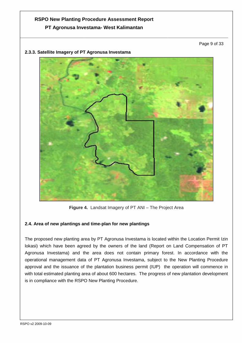
2.3.3. Satellite Imagery of PT Agronusa Investama
Figure 4. Landsat Imagery of PT ANI – The Project Area
2.4. Area of new plantings and time-plan for new plantings
The proposed new planting area by PT Agronusa Investama is located within the Location Permit Izin lokasi) which have been agreed by the owners of the land (Report on Land Compensation of PT Agronusa Investama) and the area does not contain primary forest. In accordance with the operational management data of PT Agronusa Investama, subject to the New Planting Procedure approval and the issuance of the plantation business permit (IUP) the operation will commence in with total estimated planting area of about 600 hectares. The progress of new plantation development is in compliance with the RSPO New Planting Procedure.

RSPO New Planting Procedure Assessment Report PT Agronusa Investama- West Kalimantan
Page 10 of 33
RSPO v2 2009-10-09
Figure 5. Land Clearing 2011 Planning Map and Compensated Area as of Februari 2012

RSPO New Planting Procedure Assessment Report PT Agronusa Investama- West Kalimantan
Page 11 of 33
RSPO v2 2009-10-09
3. Assessment Process and Procedures 3.1. Social Impact Assessors and their credentials
The Social Impact Assessment of PT Agronusa Investama was carried out by Aksenta. Aksenta has an office located at Jl. Gandaria VIII/10, Kebayoran Baru, Jakarta 12130, Phone / Fax: +62 21 739 6518, Email: [email protected]. The team members consist of:
1. Andri Novi ([email protected]) holds a Bachelor of Literature from the University of Padjadjaran majoring in cultural sciences, literature and linguistics. He has experience in the field of Participatory Action Research and Community Development and was a Regional Development Capacity Building & Training Expert for the National Community Empowerment Program (PNPM). He has done Social Impact Assessment in some oil palm plantation companies in Indonesia and in 2010 received accreditation from the RSPO as a Discipline Specialist for the study of HCV in the social and cultural fields. Andri Novi co-authored a book "Measuring the Autonomous Community's Guide" published by Yappika and wrote an article titled "Tata Forestry Compound; Redistribution of Wealth Natural Collection" for the Journal Komuniti forestry. He conducted a translation on the book “Art Capacity Building Training in the Development of Komuniti Forestry, issued by RECOFTC.
2. Dyah Indrapati ([email protected]) is a psychologist from the University of Indonesia. He has experience in the field of Stakeholder Engagement, Participatory Processes and Change Management. He once worked as Corporate Communications Specialist who handles Reputation Management, Crisis Communication and CSR for Friesland Campina Indonesia / Frisian Flag Indonesia. Had also become HSP Implementation Expert for USAID and AIPMNH Ausaid for Mother program, neonate and Children under Five years old Health - District Team Problem Solving (2008-2009). She worked as Technical Advisor for USAID LGSP and the Department of the Interior (2007-2009) and CIVED GRADE UNDP and UNDP (2007-2008). She has also been a consultant to the field of Sustainability & Stakeholder Engagement for companies - mining and gas companies.
3. Sigit Budhi Setyanto ([email protected]) completed a Bachelor of Agriculture at Department of Soil Science, Faculty of Agriculture, State University of Jember and experienced in the 'Development Communities Tobacco Growers' since 1990 one of them for Philip Morris Inc., manufacturer of Marlboro cigarettes. Since 2004 active as an auditor for the SCS Starbuck’s CAFÉ Practice Program in Indonesia and Papua New Guinea in addition to the Agriculture Marketing Specialist at the International NGOs for programs Rural Agro-enterprise Development (Raed). Received training nationally and internationally for Sustainable Organic, SCS-Starbucks CAFÉ Practices, Rainforest Alliance for Sustainable Agriculture, Forest Management and Chain of Custody and from DOEN for the Roundtable Sustainable Palm Oil. Together with Aksenta has studied, among others, "Social Economic Study of Oil Palm in West Pasaman and Sanggau", Social Impact Assessment and High Conservation Value Assessment for several oil palm companies in Indonesia. In 2010 received

RSPO New Planting Procedure Assessment Report PT Agronusa Investama- West Kalimantan
Page 12 of 33
RSPO v2 2009-10-09
accreditation from the RSPO as a Discipline Specialist for the study of HCV in oil palm plantations. His role in this Social Impact Assessment is as a team member with a focus on socio-ecology study of capital and sustainable livelihood.
3.2. HCV Assessors and their credentials
The HCV assessment of PT ANI was conducted by Aksenta with an office is located at Jl Gandaria VIII/10, Kebayoran Baru, Jakarta 12130, Tel./Fax +62 21 739-6518, E-mail: [email protected]). The team of consultants who conducted the study have been approved by the RSPO. Team members consist of:
1. Sujatnika ([email protected]), Bachelor of Forest Resources Conservation, Bogor Agricultural University (IPB), trained in Collaborative Management, Organizational Development, and Networking & Building Public Support in the UK. Has taught at IPB, form the forest management planning experts, devoting himself at BirdLife International. He wrote some book e.g. Conserving Indonesian Biodiversity: The Endemic Bird Areas Approach and Priority Protected Areas in Indonesia to Conserve Global Biodiversity. He is experienced in species management, protected area management and facilitating engagement in biodiversity conservation. He has experienced in multistakeholders engagement, facilitator and skilled trainers for the management of natural resources. He enrolled as a HCV RSPO Accredited Assessor - Team Leader, and HCV in this study play a role coordinating all phases of the implementation of the activities.
2. Pupung F. Nurwatha ([email protected]) has a Bachelor in Biology from University of Padjadjaran. Experienced researching wildlife (wildlife) in the wild since 1990, skilled at doing Community Based Biodiversity Assessment and manages a group of wildlife conservationists. Experienced in conducting studies of HCV in the plantation sector and has been listed in the list of HCV RSPO Accredited Assessor - Discipline Specialist with specialization HCV 1, 2 and 3 Biodiversity & Conservation.
3. Fersely G.F. Salmon ([email protected]), undergraduate (S1) completed a study in the Department of Geophysics and Meteorology, Faculty of Mathematics and Natural Sciences, Bogor Agricultural University (IPB). Active in studies related to meteorology, climatology and hydrology. Experienced in the fields of mapping, spatial analysis, and remote sensing (remote sensing) applications for natural resource management, management of water resources and watershed management (DAS), as well as environmental risk assessment. In this assessment he was responsible in the identification of HCV-4.
4. Miranti Magetsari ([email protected]), graduated from Bandung Institute of Technology, Physics Department, Faculty of Mathematics and Natural Sciences. Has attended relevant training in ISO 14001 Environmental Management System and OHSAS 18000 Management System for
RSPO New Planting Procedure Assessment Report PT Agronusa Investama- West Kalimantan
Page 13 of 33
RSPO v2 2009-10-09
Occupational Health and Safety. Experienced in the field of quality management system development and human resources, and assessment for the purposes of management system certification. Has conducted "Social Impact Assessment" and HCV 5 and 6 assessment in some oil palm companies in Indonesia under Aksenta consultancy.
5. Novriadi Zulfida ([email protected]), Master of Forestry in Forest Management Program and Watershed Hydrology at the Faculty of Forestry. Experienced in the field of IHMB (Periodic Forest Inventory Management), Management of Forest Ecosystems and Watersheds, Forest Management, MDM (Model Micro DAS) and GIS (Geographical Information System) and remote sensing techniques for the application of Watershed Management. He is experience in spatial analysis. His expertise in the HCV assessment is in the field of spatial analysis (GIS Specialist).
3.3. Assessment Methods
3.3.1. Methods used in the Social Impact Assessment
As stipulated in the RSPO Principles and Criteria, the social impact assessment was carried out by the method of Participatory Social Impact Assessment. The technique used in the study include document review, participatory observation, semi-structured interviews and in depth interviews, and focus group discussions. These techniques were chosen so that the output can be verified through triangulation method, a method that combines several methodologies of social research for Social Impact Assessment. As mentioned in the previous section, based on the RSPO New Plantings Procedure, Social Impact Assessment should be done before land development commenced in the area.
The social impact assessment was carried out through the application of social sustainability approach that is defined as towards a creation of a conducive, sustainable social environment for the processes of production and social reproduction can attained a balance and sustainable manner. The premise underlying this approach can be formulated in the following question: to what extent the presence and operation of oil palm plantations and mills have an impact on the social sustainability components.
There are 5 key elements or capitals of social sustainability that affect the livelihoods of local communities and estates. These elements are Human Capital, Natural Capital, Financial Capital, Social Capital and Physical Capital. Each capital consists of various elements and the presence of these elements plays a very important role for its stakeholders.
With these characteristics the social sustainability criteria is then developed. And in the context of sustainable palm oil production, these aspects of social sustainability were incorporated in the standards of the Roundtable on Sustainable Palm Oil (RSPO). Criteria for social sustainability is not just targets or goals but rather as an instrument for examining or benchmarking; to ensure that

RSPO New Planting Procedure Assessment Report PT Agronusa Investama- West Kalimantan
Page 14 of 33
RSPO v2 2009-10-09
management processes are aligned in the corridor of sustainability and it’s always subject to continuous improvement.
The social context of this Social Impact Assessment is the existence of people residing in and around the area of the locations permit. In the field, Social Impact Assessment is carried out as follows.
Table 2. Scope of Social Impact Assessment of PT ANI
No. Aspect Information 1. Number of members of the Aksenta Team 3 persons 2. Number of days devoted 3 days 3. Number of formal meetings 1 meeting 4. Number of participants of formal meetings 13 people 5. Number of informal meetings 1 meeting 6. Number of participants interviewed in the field 9 people 8. Number of stakeholders visited and interviewed 12 Parties 9. Number of locations visited 6 Locations 10. Number of observation points 20 points of observation 11. Number of information sources in the field 31 persons 12. Number of documents reviewed 9 documents 13. Number of locations / events recorded 56 selected photos
Source: Laporan Kajian Dampak Sosial PT Agronusa Investama (Report of SIA of PT Agronusa Investama), September 2011, pp. 2-8.
The Social Impact Assessment was conducted following the rules or principles as follows:
1).Participatory; identification of issues and extracting information through a participatory process. This participatory approach puts the participants as subjects to map the social issues they experienced, delivering opinions and aspirations, and are involved in designing and managing change;
2).Multistakeholder; identification of issues and search for information was carried out by involving a multi stakeholder approach particularly those who are directly or indirectly impacted;
3).Rapid and Ex-ante; issues and information obtained will be rapidly analyzed and the predicted trend is established. Due to the limited time available, the impact cannot be measured based on factual field data to measure the realized impact.
4).Appreciative; identification of issues and guided in a positive way of extracting information, not limited only to know the gap that occur but also to explore the hopes, potential, and ideas in finding solutions to social issues that might occur.

RSPO New Planting Procedure Assessment Report PT Agronusa Investama- West Kalimantan
Page 15 of 33
RSPO v2 2009-10-09
5).Social-Learning Cycle; social impact assessment is not a linear process but rather a cyclical process, which serves as a social learning processes to respond to environmental changes that occur.
The assessment was conducted using the combination of methods/techniques below:
1).Desk reviews; this method is used to obtain an understanding on social and environmental context of the study area, conducted at an early stage prior to the field work.
2).Dialogue; this method is used to identify key social issues, key stakeholders, (potential) impacts created by the operational of the management units, as well as to explore hopes, opinions and aspirations in search of a solution to the issues that occur, carried out through meetings with the representatives of local communities discussing and exploring specific topics (Focus Group Discussion);
3).Field observation; this method is used to comprehend the facts that indicate the occurrence of social issues and social impacts that might happen;
4).Semi-structured and in depth interviews; this method is used to explore and gain a deeper understanding of the issues that arise during in-depth interviews conducted with selected key figures, the informant, informant choices based on knowledge or direct perpetrator or who receive the impacts.
5).Triangulation; a combination of the above methods integrated to verify each of the issues, opinions, and ideas that arises.
3.3.2. Methods used in the HCV Assessment
Scope of the study area is within the location permit granted to PT ANI and the study is extended to surrounding villages and other areas that are considered important. Field survey was conducted on 16 to 19 September 21 2011 to examine areas that need to be observed. More than 29 observation points located in and around the study area that are relevant to this study were visited. Distribution of sites visited during the assessment process is provided in Figure 5.
During the field assessment, the HCV experts were accompanied by the staff of PT ANI and also the local communities who are knowledgeable of the status of their physical as well as social environment and related issues within the study area. In addition to making observations and measurements in the field, the team also extracted information from the local community both through individual interviews and through focus group discussions (FGD). On several occasion the team also performed confirmation and cross-check findings through purposive sampling; i.e., area of confirmation includes the figures, the owners of the enclave (if any), and the beneficiaries or where the relevant areas are.

RSPO New Planting Procedure Assessment Report PT Agronusa Investama- West Kalimantan
Page 16 of 33
RSPO v2 2009-10-09
Figure 6. Observation point distribution during field visit (Source: Laporan Identifikasi HCV PT ANI, p. 2-10)
Definition and scope of HCV assessment used in the palm oil sector is still very much based on the HCV concept applied in the forestry sector. For the purpose of this assessment, reference was made to the Indonesia HCV Toolkit 2008 [Identification of High Conservation Value Areas in Indonesia developed by the Consortium for HCV Revision Toolkit Indonesia (2008)] and the HCV Toolkit (2003) of the ProForest. Other references used that are relevant in the assessment also include IUCN, CITES, and other relevant guidelines/regulations in Indonesia and these are listed in Appendix 3.
a. Methods for the identification of HVC 1, 2 and 3
Target identification of HCV 1, 2 and 3 is to find areas of significant value in the context of biodiversity. Important areas are characterized by the status of the area, the authenticity of a community or

RSPO New Planting Procedure Assessment Report PT Agronusa Investama- West Kalimantan
Page 17 of 33
RSPO v2 2009-10-09
ecosystem, and presence of flora and fauna of significant values. The importance of flora and fauna refers to the legal status, endemicity (endemic, restricted distribution) and scarcity (rare, threatened or endangered species extinction) in accordance with national regulations or international (IUCN and CITES) that protects the flora and fauna. Apart from that, the significance of wildlife and habitats was assessed based on the ecological role of these species from the indigenous or local community cultural point of view.
Rapid assessment method (reconnaissance survey) was used to examine the existence of important flora and fauna. The presence of a species of fauna was recorded by:
• The results of direct observation, either visible or audible voice (diurnal and nocturnal animals),
• The existence of the former or the remnants of the activity of animals left in their habitat (such as footprints or footprint marks, scratches on tree trunks, nests, scales, shells snake skin, feathers of birds or mammals that escapes, etc.).
• Encountered pieces of the remnants of animal body parts (skull, horns, leather, fur, fangs, scales, and other animal body parts are still recognizable), hunted or captured species by the general public from the study area. Interviews were conducted to confirm the information in regard to location and time period when the species was captured or hunted.
• Secondary information, on the existence of animals recorded based on third party informant, such as by citizens or local field officer. The validity and consistency of secondary information was reconfirmed by double-checking (check and recheck) with different parties, as well as by examining the completeness of the description of a species from the interviewee. All secondary information collected will be matched with the distribution of natural and historical presence of wildlife in these locations (as noted in the literature) and compared with the condition and type of existing habitat where the survey was conducted. The discrepancy between the description of a species of animal with its natural distribution area and condition of existing habitats, wildlife species can lead to the questionable existence of that particular species in study area.
b. Methods for the identification of HVC 4
To identify the presence of HCV 4 in an oil palm plantation, there are two approaches used. The first approach is to determine the interactions and relationships between water system and plantation land in the context of the landscape or the wider region and hence this analysis will include the area outside the permit area locations. The second approach is to determine the significance of certain areas and its influence on the plantation area; this is a more localized approach within the context of the proposed project site. Based on these two approaches, the identification of HCV 4 is a form of secondary data analysis, by integrating field survey and secondary data analysis.
Identification of the sites with HCV 4 is done by analyzing the region in terms of spatial, landscape, topography, and location of the river system and followed by field surveys and interviews with

RSPO New Planting Procedure Assessment Report PT Agronusa Investama- West Kalimantan
Page 18 of 33
RSPO v2 2009-10-09
respondents. Field observations were carried out at selected locations, i.e. locations of springs, streams, rivers bank conditions, and some water sources coming from the estates that flow into the hydro system of the area. In general, the identification of the presence of HCV 4 is related to the hydrological function as water storage and water source to various aspects of life as well as disaster risk management (floods, landslides, fires, drought, etc.).
c. Methods for the identification of HVC 5 and HCV 6
Focus of identification and assessment of HCV 5, is done over the area within the plantation which is of importance for the fulfillment of basic needs of local communities. For the identification and assessment of HCV 6, is done over the area within the plantation which have significant value to safeguard the identity and continuity of tradition / culture of local communities. The method performed in the assessment of HCV 5 and 6 was through:
• Literature reviews.
• Participatory mapping with communities on areas that are considered to have elements of HCV 5 and 6
• Interviews with the community, both individually and through Focus Group Discussion (FGD)
• Assessment and analysis of field survey results.
• Synchronization of the results of the various studies conducted (field and literature review)
d. Stages of HCV Identification
HCV identification/assessment is generally done through a series of steps consisting of: (i) Pre-assessment that includes a desk study and survey designing, (ii) Field Survey in the form of observations and interviews, (iii) Data and Spatial Analysis which is a further analysis and synthesis with the pre-assessment results and field surveys to determine the presence or absence, location, status, and landscapes of the HCVs in the project area (Figure 7).

RSPO New Planting Procedure Assessment Report PT Agronusa Investama- West Kalimantan
Page 19 of 33
RSPO v2 2009-10-09
Figure 7. Stages of HCV identification (Report: Identifikasi HCV PT ANI, p. 2-7)
3.4. Stakeholders’ Consultation
The process of the HCV and SIA development and preparation of management and monitoring plans of PT Agro Nusa Investama involved the consultation of the relevant stakeholders such as governmental offices, the local community, the government appointed official of local village and sub-district, the local NGOs, independent consultant (Aksenta) and the local existing plantation companies. On March 7, 2012, a stakeholders’ consultation of the HCV and SIA management plan involving the relevant stakeholders outlined in the above and also the management team of PT Agro Nusa Investama Sambas was conducted and facilitated by the RSPO approved assessors from Aksenta in Sambas. Communications with the key stakeholders were carried out through interviews, interaction, and discussion between the company and the stakeholder’s in order to gain a better understanding of the management plans for the stakeholders. The inputs from the presentation by various stakeholders during the stakeholders’ consultation workshop in Sambas District on March 7, 2012 related to HCV, were also integrated into the into the SIA document.
The issues raised during the workshop were: Communication issues between the stakeholder and information sharing (publications/forum) is about labor recruitment and job creation. (The question and answer records are summarized in the report on stakeholders’ consultation workshop in SIA document).

RSPO New Planting Procedure Assessment Report PT Agronusa Investama- West Kalimantan
Page 20 of 33
RSPO v2 2009-10-09
4. Summary of Assessment Findings 4.1. Social Impact Assessment
The parties (stakeholders) in the context of the Social Impact Assessment are the parties who create or received the impact of the presence and operation of the oil palm plantation. Based on the results of field studies, some 14 parties were identified; of which two are internal parties and the rest of the 12 are external parties. List of the parties and their description as well as its role is presented in Appendix 4 and Appendix 5.
The results of the identification of social issues through participatory processes with stakeholders indicated that there are at least 15 issues in the context of local resident and 4 social risk that are of concern and can possibly have an impact on the corporate social responsibility of PT ANI. In addition there are 8 conditions that are inherent in nature. Conditions that are defined as inherent are pre-existing conditions that happen not related with the company’s presence but have an impact on the community. These issues are presented in Table 3 and Table 4.
Table 3. Social issues identified through the participatory processes
No Category (Source Issues)
No Social issues
I.
The presence and corporate awareness campaign
1. Communities in and around project area already knew of the existence of PT Agro Nusa Investama
2. Company co-operatives have met the communities three times as part of their awareness campaign to inform community of their plan for oil palm plantation expansion in the area
3. The company either directly or through their co-operatives have a fairly well established communications with the local government and local communities.
4. Local communities in the surrounding area are still not well informed of the company oil palm expansion plan
5. Local communities are also not aware of the plasma program in the area because so far the discussion on the plasma development is done only with the Serimaram landowners.
6. Local communities who have tilled the land are not sure of how their land will be managed from now on and how it is done in relation with the Serimaram co-operatives. At this moment there is no clear agreement on this matter.
II. Changes in land use by the allocation of the land for oil palm plantations
7. All this while, Serimaram land has been used as a rubber plot and local timber sources for the firewood, light construction and boat building. Hence land development for oil palm will further deplete these natural resources.
8. Community generally feel that income from their rubber plot is sufficient to support their daily expenses. Only a small part of the area within the Location permit is currently planted by community with rubber (see Figure 4.1). A large part of these rubber plots is totally neglected and only small parts are being actively managed and tapped.
9. Most of the land occupants admitted that the ownership of land is by the family of Serimaram and they have obtained permission to tilled the land. However they are reluctant to surrender back their land and they hope that the land will be enclaved within the location permit.

RSPO New Planting Procedure Assessment Report PT Agronusa Investama- West Kalimantan
Page 21 of 33
RSPO v2 2009-10-09
No Category (Source Issues)
No Social issues
10.
Some land occupants do not recognize the land ownership of the Serimaram family and they disagree that the Co-operative of Serimaram has offered the land for the development of oil palm plantation and they are not willing to surrender the Serimaram land. Cooperative hopes that they can buy back the land from these occupants.
III. Operation of oil palm estates (land clearing and nursery)
11.
They will be a high mobilization of heavy equipment into the project area of PT Agro Nusa Investama, and part of the access will go through public road. There is some concern that activities will cause some damage to the existing road.
12.
The company may face challenges in getting workers from the local population because most of them are not interested to work in Indonesia and prefer to work in plantations in Malaysia.
13.
Workers recruited from other parts of Indonesia to fill in the vacancy will have different culture and religion and this will probably result in undue social pressure.
IV. The role and contribution of the company to the regional development
14.
Serimaram Cooperative members will benefit from the plasma with PT Agronusa Investama.
15.
Local people would benefit from the developments of new roads and better road access if there were road maintenance prior to the transportation of heavy equipment into the project area. But they also may be adversely affected if the road, maintenance is poor and the existing roads get damaged due to heavy utilization.
Table 4. Social risks and local given situation to PT ANI
No Category No. Issues I. Social risk 1. There is still no agreement among villagers on the issue of intervillage boundary. 2. Part of the land within the location permit has already been established with
community rubber plot and farmland. 3. Customary ceremonies are still being practiced during time of birth ritual, marriage
ritual and death ritual though the essence is not as strong as before. 4. “Alas Hak” is a document issued by Sultanate of Sambas and endorsed by the
Dutch Colonial Government and this is recognized by the 11 villages in the area. But this endorsement is not recognized by the National Land Agency (BPN)
II. Given issues 5. Generally, the villages still use river for bathing, washing and waste disposal. Due to the tidal effect and the water from peat source, the quality of the river water is generally poor. Another common source of water is a rainwater and bore wells with the quality of water is not good enough for staple water.
6. There is an existing road access that transverse through the area leading to Sambas, the capital city of this district. But due to the poor road condition many still rely on river transport.
7. Sabung village has affordable health facilities, education facilities and availability of clean water. But electricity supply from private generators remains expensive as price of fuel reaches Rp 8000/lit and there is also limited telecommunication coverage in the area.
8. There is already clean water distribution to the villages but unfortunately its not well maintained. Several village offices have also been built but not being utilized.
9. The hamlet and Senabah village still does not have sufficient telecommunication coverage. Television network is only obtainable through satellite disc.
10. There is a small clinic in each village but there are no trained midwives to man these clinics. Most villages still resorted to traditional healer to serve them on health matter.
11. The Melayu community gained some monetary assistance in the form of credit from the rubber middleman to meet their daily needs. The Dayak community invested their earning with Credit Union – Pancur Kasih based in Sambas.
12 Sources of income for the villagers came mainly came from sales of

RSPO New Planting Procedure Assessment Report PT Agronusa Investama- West Kalimantan
Page 22 of 33
RSPO v2 2009-10-09
No Category No. Issues rubber produce, sales of prawn and fish, timber and rice farming. However there are some communities who find that farming is no longer profitable due to high pest attack.
Based on the analysis of social impact assessment it can be concluded that there are potential and significant impacts to the sustainability of the local residents due to the presence of PT Agronusa Investama. The most important potential social impact of the company's presence is likely to be related to the future demands of the heirs of Serimaram considering there is no clear or official linkage that could differentiate between ordinary members of the Cooperative of Serimaram and those are heir to the clan. Recruitment of workers from other areas outside the sub-district or from other district will also have a potentially significant social impact on the local communities. Besides the above other potential social impacts can also arise from land clearing activities and plantation development partnerships as well damage to existing road that may occur.
Land clearing may bring about a great social impact largely because boundaries between villages have not been agreed or demarcated. The presence of immigrants in the area may also influent the political conditions, customs and local culture. Land offered for oil palm development will eventually caused a reduction in land available for paddy planting or rubber garden. Such land pressure is likely to be felt in the Sabung village, which has the highest population density as compared to other villages.
The immediate activity that will have an impact on social sustainability of local community will be the recruitment of labor force for the land development and nursery establishment. As per the company's plans, the initial stages of these recruitment activities will potentially have a direct impact on the villagers, amounting to 760 people and 181 households. Estimated recruitment of workers in 2012 will be 100 people or 13.16% of the total population of the village of Sabung or 55.25% of total households. A number that indicates that the impact of the company's presence will be huge. The potential social impact of companies will be positive if these challenges can be solved amicably, otherwise it becomes negative and develop into a conflict if it is not managed well.
So far, the activities that already have impacted the community are the recruitment of workers for field survey and nursery. Although this social impact is somewhat limited, locals from the area are already experiencing the impact by being directly involved in the company activities.
Based on the study the following conclusions and recommendations can be formulated. These recommendations will be incorporated into the Social Management Plan:
1. Companies need to develop an appropriate management plan as a part of exercising Corporate Social Responsibility towards sustainable development. The plan should be developed in a participatory manner by involving local stakeholders based on the results of this social impact study and the result should be integrated with the local government development program in order

RSPO New Planting Procedure Assessment Report PT Agronusa Investama- West Kalimantan
Page 23 of 33
RSPO v2 2009-10-09
to achieve a better synergy. The development of the plasma program and the Co-operative should always be an integral part of this Social Management Plan.
2. As part of the Social Management Plan, the company need to develop a systems and procedures to recruit and adapt workers to the local condition. And also to develop a procedure and system to get local community and government involvement in the company affair.
3. Companies can develop a comprehensive systems and procedures for communication that such as public information that will incorporate among other things, company profiles, plans, environmental management and mechanisms of cooperation and partnership. The communication system should also include media planning, and the target audience who will be receiving this information. The Communication should also cover, applicable laws and regulations, the principle of FPIC (Free and Prior Informed Consent) and NPP (New Planting Procedure) RSPO and a brief summary of the results of this Social Impact Assessment as well as the aspirations of local residents.
4.2. Environmental Assessment
At each of these different stages of development, the impact to the ecosystem (environmental aspect) can be divided into:
4.2.1. Physical-Chemical Component
a. Reduction in air quality and increased in noise level
This impact is likely to occur during the mobilization of equipment, construction of infrastructure and also land clearing. All these activities will not only increase the noise pollution but will also increased the dust level in the air and increased smoke emission.
When the plantations is in operations, there will also be an increased in vehicle movement e.g. Fresh Fruit Bunches (FFB) transportation and other agricultural input like fertilizer and all these will increased the level of dust and emission level in the air.
b. Increased in surface run-off
This impact is at its greatest during the land development stage when the natural vegetation is being cleared. Clearing of vegetation will automatically removed the natural sponge and cushion that will reduce the impact of rainfall, the main source of run-off. This will have a direct impact on the erosion and sedimentation, which in turn will determine the water quality of rivers and water bodies in the area.
The intensity of the surface run off will depend on the size of area being opened and also vegetation removed.
c. Increased in erosion and sedimentation

RSPO New Planting Procedure Assessment Report PT Agronusa Investama- West Kalimantan
Page 24 of 33
RSPO v2 2009-10-09
Again this impact is related to the surface run off which will also depend on the size and amount of natural vegetation being removed during the land clearing.
d. Reduction in water quality
At the land clearing level, water quality is directly related with the erosion and sedimentation that is occurring in the area at the time of land clearing/development. The amount of sedimentations caused by the erosions will be carried by the run-off into the water bodies and also river and streams within the project area.
The impact on the water quality will be along the rivers or streams that runs through the project area, especially when that particular river and streams is a water source for local community.
e. Increased in soil fertility
The high standard of agronomic practices normally associated with oil palm management will in-crease the soil fertility of the cultivated area.
This positive impact is likely to be experienced throughout the planted area.
f. Potential for open burning
At the land development stage the dried vegetation at the windrows stack is a potential source of fire hazard during the dry weather.
This is a big impact and can be widespread to cover the entire plantations
4.3. HCV Assessment
According to the Map of Designation of Forest Area and Inland Water for West Kalimantan Province (Peta Penunjukan Kawasan Hutan dan Perairan Provinsi Kalimantan Barat) issued by the Ministry of Forestry of the Republic of Indonesia (2009), the land status of the study area is classified as non-forest land (Other Use Area- APL). The study revealed that there are no primary forest areas left within the additional location permit of PT ANI. Use of timber on the land has been the legacy of the Royal Family of Sambas (Serimaram) since 1986. In the report of HCV (Aksenta, 2011), stated that the land covers in this region are dominated by local community farmland, rubber plot/garden, as well as patches of secondary forests.
There are three types of HCV occur in the license area of PT ANI, i.e. HCV 1, HCV 4, and HCV 6 covering a total area of approximately 92 hectares or 9% of the total area size of the study area (1,024 hectares). The presence of HCV 1 was due to the existence of an important area of refugia for the species within the permit site. The species that are considered important are Presbytis chrysomelas (Critically Endangered). In addition to the key species, there are other threatened species were recorded i.e. 4 Endangered species, 11 Vulnerable species, two species are listed in the CITES’s Appendix (Refer to Appendix I.).

RSPO New Planting Procedure Assessment Report PT Agronusa Investama- West Kalimantan
Page 25 of 33
RSPO v2 2009-10-09
In regard to HCV 4 there are water sources and firebreaks in the form of streams of water catchment areas and flood control areas within the project site. In addition to this they are areas of erosion and sedimentation control found in the border-demarcation of the river.
In regard to HCV 6, there is an unidentified old graveyard that is considered sacred by the local community. Summary of the presence of HCV area in the study area is shown in Table 5 and map of the distribution of its location is shown in Figure 8.
Table 5. Summary of HCV present in the additional areas of PT ANI
HCV Type The existence Information HCV 1.1 None Did not reveal any areas that have or provide supporting functions to
protect and / or conserve areas for biodiversity. HCV 1.2 Present Endangered species that were found, namely Presbytis chrysomelas,
Hylobates muelleri, Manis javanica, Hosemys spinosa and Orlitia borneensis,
HCV 1.3 Present They are area that formed habitat for threatened species that are endemic endangered and protected.
HCV 1.4 None Did not find any area that forms a habitat for species or set of species (animals) that used these sites as temporary congregation of species. Trajectory pathways are important to wildlife in this category.
HCV 2.1 None There are no natural landscape areas with the capacity to maintain natural ecosystem processes or dynamics
HCV 2.2 None Did not reveal any landscape that contains two or more contiguous ecosystems
HCV 2.3 None Did not reveal any areas containing a viable population of most naturally occurring species.
HCV 3 None Absent of the existence of a unique ecosystem and / or forest conditions that has an intact formation
HCV 4.1 Present There is a river that acts as a water source and has good water storage in the form of a secondary forest in the upper DTA. The riparian areas also act as a natural flood control
HCV 4.2 Present Areas of importance along the natural riparian buffer for the prevention and control of erosion and sedimentation.
HCV 4.4 Present Areas that occur as natural barriers to the spread of natural destructive fire. HCV 5 None Did not find any natural areas that have important functions to fulfill the
basic needs of local communities HCV 6 Present They are areas that have important functions to local communities'
traditional cultural identity. Source : Laporan Identifikasi HCV PT ANI (Aksenta, November 2011)

RSPO New Planting Procedure Assessment Report PT Agronusa Investama- West Kalimantan
Page 26 of 33
RSPO v2 2009-10-09
The threats to the existence of HCV
Some threats to the existence of HCV in the PT ANI, both actual and potential, have been identified as follows:
1) Illegal logging and land clearing for agriculture
2) Game hunting of wildlife
3) Illegal fishing through fish poisoning
4) Burning for land clearing for subsistence farming and oil palm development
5) Land development by contractors who do not comply with company procedures in safeguarding HCVs
Figure 8. Map of HCV areas of PT ANI (Source: Laporan Identifikasi HCV PT ANI)
RSPO New Planting Procedure Assessment Report PT Agronusa Investama- West Kalimantan
Page 27 of 33
RSPO v2 2009-10-09
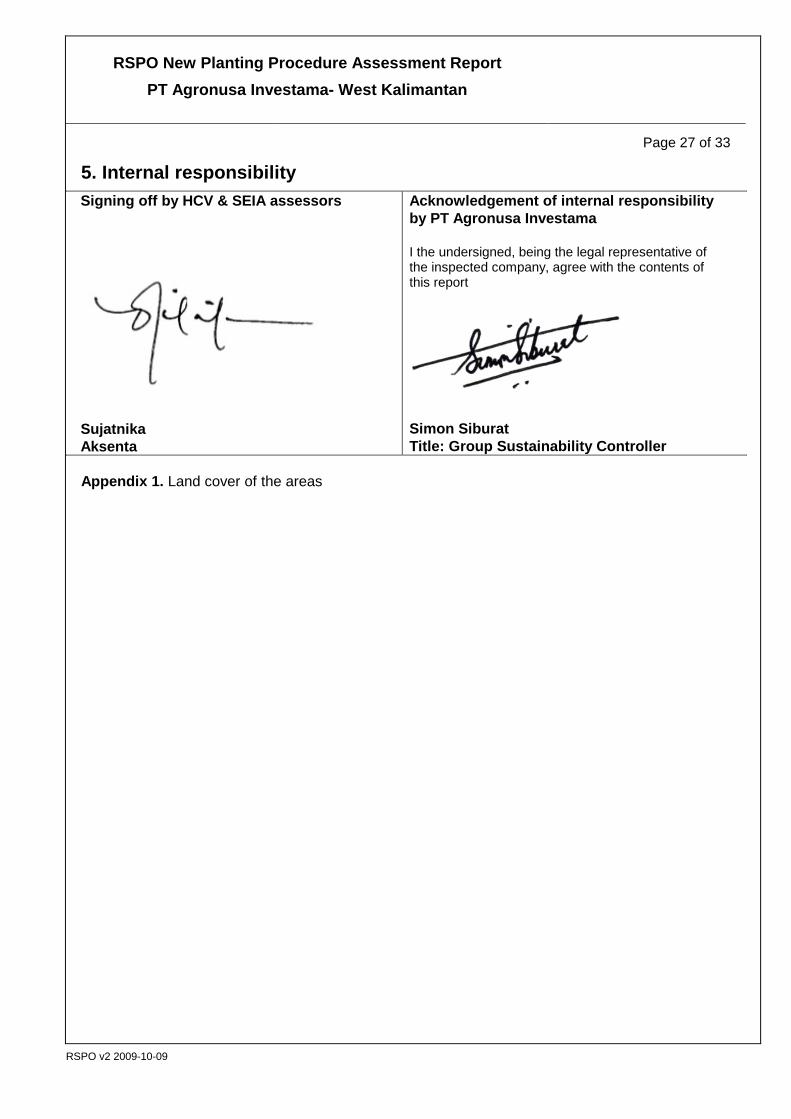
5. Internal responsibility Signing off by HCV & SEIA assessors
Sujatnika Aksenta
Acknowledgement of internal responsibility by PT Agronusa Investama I the undersigned, being the legal representative of the inspected company, agree with the contents of this report
Simon Siburat Title: Group Sustainability Controller
Appendix 1. Land cover of the areas

RSPO New Planting Procedure Assessment Report PT Agronusa Investama- West Kalimantan
Page 28 of 33
RSPO v2 2009-10-09
Source: Landsat 7 ETM+ SLC Off, 2010 in Laporan Identifikasi HCV PT ANI (Aksenta, 2011) pp. 3-5
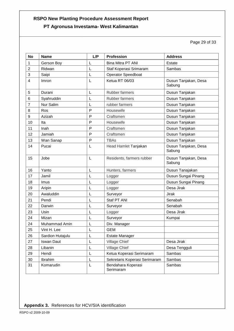
Appendix 2. Participants of FGD during SIA at the PT ANI Srimaram, September 2011
RSPO New Planting Procedure Assessment Report PT Agronusa Investama- West Kalimantan
Page 29 of 33
RSPO v2 2009-10-09
No Name L/P Profession Address 1 Gerson Boy L Bina Mitra PT ANI Estate 2 Ridwan L Staf Koperasi Srimaram Sambas 3 Saipi L Operator Speedboat 4 Imron L Ketua RT 06/03 Dusun Tanjakan, Desa
Sabung
5 Durani L Rubber farmers Dusun Tanjakan 6 Syahruddin L Rubber farmers Dusun Tanjakan 7 Nur Salim L rubber farmers Dusun Tanjakan 8 Ros P Housewife Dusun Tanjakan 9 Azizah P Craftsmen Dusun Tanjakan 10 Ita P Housewife Dusun Tanjakan 11 Inah P Craftsmen Dusun Tanjakan 12 Jamiah P Craftsmen Dusun Tanjakan 13 Wan Sanap P TBAs Dusun Tanjakan 14 Pucai L Head Hamlet Tanjakan Dusun Tanjakan, Desa
Sabung
15 Jobe L Residents, farmers rubber Dusun Tanjakan, Desa Sabung
16 Yanto L Hunters, farmers Dusun Tanajakan 17 Jamil L Logger Dusun Sungai Pinang 18 Imus L Logger Dusun Sungai Pinang 19 Aripin L Logger Desa Jirak 20 Awaluddin L Surveyor Jirak 21 Pendi L Staf PT ANI Senabah 22 Darwin L Surveyor Senabah 23 Usin L Logger Desa Jirak 24 Mizan L Surveyor Kumpai 24 Muhammad Amin L Div. Manager 25 Vint H. Lee L GEM 26 Sardion Hutajulu L Estate Manager 27 Iswan Daut L Village Chief Desa Jirak 28 Libanin L Village Chief Desa Tengguli 29 Hendi L Ketua Koperasi Serimaram Sambas 30 Ibrahim L Sekretaris Koperasi Serimaram Sambas 31 Komarudin L Bendahara Koperasi
Serimaram Sambas
Appendix 3. References for HCV/SIA identification

RSPO New Planting Procedure Assessment Report PT Agronusa Investama- West Kalimantan
Page 30 of 33
RSPO v2 2009-10-09
. No Daftar/Tipe Referensi Keterangan
1. Vulnerability status according to the World Conservation Union (IUCN), 2010
CR : critically endangered, EN : endangered, VU : vulnerable, NT : near threatened,
2. Status in terms of an Convention on International Trade in Endangered Species of Wild Fauna and Flora (CITES), 2009:
App. I: a list of all species of plants and wildlife that are traded internationally banned in all its forms
App. II: list of species requiring trade arrangements, so that the population is not threatened with extinction
3 Republik of Indonesia Legislation • Dierenbeschermings ordonantie 1931 (Wild
Animals Protection Ordinance) Protection of wildlife
• Agriculture Ministerial Decree No. 421/Kpts/Um/8/1970
Protection of wildlife
• Agriculture Ministerial Decree No. 66/Kpts/Um/2/1973
Protection of wildlife
• Agriculture Ministerial Decree No. 90/Kpts/Um/2/1977
Protection of wildlife
• Agriculture Ministerial Decree No 327/Kpts/Um/5/1978
Protection of wildlife
• Agriculture Ministerial Decree No. 247/Kpts/Um/4/1979
Protection of wildlife
• Agriculture Ministerial Decree No. 716/Kpts/Um/10/1980
Protection of wildlife
• Government Regulation No. 7 of 1999 Protection of wildlife • Public Works Ministerial Regulation No.
63/1993 Determination of the width of border rivers
• Act No. 41 of 1999 Forestry • Act No. 7 of 2004 Water Resources
• Forestry Ministerial Decree No. 328/Menhut-II/2009
Determination of Priority Watershed
4 • Map of Designation of Provincial Forest Areas and Inland Water.
To verify the land status of an area whether or not is classified as forest area

RSPO New Planting Procedure Assessment Report PT Agronusa Investama- West Kalimantan
Page 31 of 33
RSPO v2 2009-10-09
Appendix 4. Stakeholders analysis of external parties during the assessment through participatory processes
No Stakeholders Description Role
1. Local Government (District and related agencies)
District level government with its agencies that formulate policy, planning activities/ programs that can influence company policy, government administration and public services.
Among local government agencies that have a very important role in the issuance of Permit Location is the Regent. But the role of the Regent is highly influenced by or inter related with the Departmental head in his regency. Government agencies that play a role in the functionality of PT Agronusa Investama include the Agencies of Agriculture, Plantation and Forestry and the National Land Agency at the District level. So far all of these agencies were not involved in the assessment process.
2. Camat Camat serves as a coordinator of governance in the sub district, under his charged and responsible to the Regents through the District/Regent Secretary
Party district is an important stakeholder in the stage of licensing arrangements and disseminating corporate action plans. PT Agronusa Investama has established good relations with the Sub-district of Sajad, Subah and Sejangkung.
3. Village Chief The village chief is the head of the village administration. The position of the Village chief is a political appointee and is elected by the villagers. The village chief has an important role, but his role varies from one village to another. The village chief is not a subordinate to the Sub-district head (Camat). Sub-district head is only a coordinator.
The village head plays a very significant role in the development of oil palm plantations, due to the administrative power over village land ownership. Village heads generally have a great influence, over the acceptance or a rejection of an investment into the village. He also has the influence in regulating the availability of workforce.
4. Hamlet head Head of Hamlet is the one who chaired a hamlet or sub-village, a unit of housings under the village. The Hamlet head is appointed and dismissed by the Village Headmen. A hamlet headman can be assigned to look after one or more hamlet in a given area.
In the hamlets surrounding area permit corporate locations. Head Hamlet has an important role in land issues and development. They can help or hinder the dissemination of company activities during the company's operational processes. Knowing the process of land acquisition. Carry out consultations within the hamlet boundary agreements with other hamlets.
5. General Community / farmers
The collectors or rubber tappers who do not have their own farm. They worked on farm or rubber plot owned by the heirs of Serimaram family.
The collectors or rubber tappers who do not have their own gardens. They worked on plantations owned by the heirs Serimaram family. These groups of people will be directly affected by the conversion of rubber plot into oil palm plantations.
6. Family heir land of Serimaram
Serimaram heirs of the family land are the descendants of Serimaram who controls the land inheritance.
These heirs have the right to control and large tracts of land in the area of within the Location permit
7. Small holder (Plasma) Oil Palm Farmers
Someone who is a member of an oil palm cultivation scheme. He will be actively managing the plot and hope to sell the FFB to support his livelihood.
He will need to surrender some part of his land holdings in order to qualify for the scheme. Hence his area of land ownership will be reduced. But in doing so he will have an opportunity to be part of a scheme that can support his livelihood through the sales of FFB.

RSPO New Planting Procedure Assessment Report PT Agronusa Investama- West Kalimantan
Page 32 of 33
RSPO v2 2009-10-09
No Stakeholders Description Role
But for the Serimaram land owners there will be more passive in the management of the scheme. This is because the company will manage the scheme areas.
8. Cooperative Economic institutions which act as a platform for its members to conduct business and economic activities
The cooperative has a very strategic position to form a business partnership with the company. As it is the Serimaram cooperatives has been formed.
9 Public Local communities that are found within or around the location permit whose presence will have a direct or indirect influence on the activities of the company.
These community can be a source of human resources for the company
10. Craftsmen Wives of farmers who took advantage of their free time at home to do craftwork and through the monthly sales of these craftworks the income is used to support their livelihood.
The presence of the company will create a multiplier effect to the craftsmen due to increase in purchasing power of the community
11. Timber fellers Local communities who reside in the Serimaram land often source timber in the area for constructions; boat making and firewood, There are two group of timber feller. Those that permanently reside in the area and those that are coming in from outside the area.
This timber feller will be affected once the area are converted to oil palm plantations. They will lose their revenue from the sales of timber. This is particularly so for those that who are permanently residing in the land. Those that reside outside the land can always find an alternative source in other areas.
12. Housewife Housewife does the daily housework and in the dayak community there is no strict division of task between wife and task in doing housework. But among the Melayu community there is a clear difference on what husband and wife should be doing.
Housewives whose children have grown up will have free time to work in the plantations.

RSPO New Planting Procedure Assessment Report PT Agronusa Investama- West Kalimantan
Page 33 of 33
RSPO v2 2009-10-09
Appendix 5. Stakeholders analysis of internal parties during the assessment through participatory processes
No Stakeholders Description Role
1. Management Is a body that perform the functions of planning, organizing, coordinating, and controlling resources to achieve the company objectives (goals) effectively and efficiently? Effective means that the goal can be achieved according to plan, while efficient means that tasks are executed correctly, organized, and in accordance with the plan schedule (Ricky W. Griffin).
Perform all operational activities of companies in the field in accordance with respective department and responsibilities. Running Managerial functions. Establish policies, plans, procedures, activities / programs, management, administration, supervision and sanctions and rewards are included in this are the groups organization that serves as a support (support) operations.
2. Staff and employees
Operational employees in all units of work in the plantation that are directly recruited and paid by the company.
There are at least 3 main groups of employees, i.e. Field Manager, Field Assistants and foremen and workers who work in land clearing and nursery