Roman gate remains under Head Street - University of Essex
34
Issue no 20 2007 Roman gate remains under Head Street Latest discoveries at the chariot racing track Colchester's friaries investigated The cemeteries of Roman Colchester £2. 95
Transcript of Roman gate remains under Head Street - University of Essex

Issue no 20 2007
Roman gate remains under Head Street L a t e s t d i s c o v e r i e s a t t h e c h a r i o t r a c i n g t r a c k
C o l c h e s t e r ' s f r i a r i e s i n v e s t i g a t e d
T h e c e m e t e r i e s o f R o m a n C o l c h e s t e r
£2. 95

Published by Colchester Archaeological Trust, 1 2 Lexden Road, Colchester, C03 3NF.
ISSN 0952-0988
©Colchester Archaeological Trust 2007
Edited and layout by Philip Crummy
Printed by PrintWright Ltd, Ipswich
The Colchester Archaeologist magazine is supported by the Friends of Colchester Archaeological Trust - see page 32.
Front cover. Chris Lister recording remains of Roman Head Gate in Head Street.
Below. Le Cateau and Cavalry Barracks, March 2007 . Photograph by Van Cols Ltd.
Friends of the Colchester Archaeological Trust
If you are interested in following archaeological discoveries in Colchester, then why not
consider joining the Friends of the Colchester Archaeological Trust? The subscription
rates are modest, and include an annual copy of The Colchester Archaeologist
magazine delivered to you as soon as it is published. You can also join tours of current
sites and organised trips to places of historical and archaeological interest in the region.
The annual subscription rates:
Family membership £6.00
Adults and institutions £5.00
Children and students £2.50
Further details can be obtained from Maureen Jones, Friends of Colchester
Archaeological Trust, 5 Ashwin Avenue, Copford, Colchester, Essex, C06 1BS.
Corporate members of the Friends of
the Colchester Archaeological Trust:
Plaiter Claiborne,
Birkett Long,
Colchester Civic Society,
Faculty of Building (East Anglia),
Morley, Riches & Ablewhite,
R G Carter,
The Breakfast Club.
Handelsbanken Chelmsford branch
'is pleased to support Colchester Archaeological Trust in their valuable work'
David Wilson 01245 347788

contents Circus u p d a t e latest discoveries at the chariot racing track
G i a n t R o m a n c h a r i o t rac ing mosa ic is c o m p l e t e d ! by Peter Herring
Grave concerns : t h e cemeter ies o f R o m a n Colchester by Howard Brooks
M a k i n g u p f o r t h e next l i fe by Nina Crummy
T w o arches o r one? did the Roman Head Gate have more than one entrance?
R o m a n archaeology by Don Shimmin
monumental structures near the Temple of Claudius
R o m a n rema ins - new views by Howard Brooks
remains of Roman houses near the Mercury Theatre
T h e lost c h u r c h o f t h e Crossed Friars by Stephen Benfield
T h e lost f r i a ry o f t h e Grey Friars building remains uncovered at the adult education college
O f f t o c h u r c h . . . by Kate Orr
investigations in three village churches
Bodies in t h e car p a r k by Howard Brooks and Ben Holloway
3,000 year old remains under Chelmsford park-and-ride
T h e dykes o f C a m u l o d u n o n by David Grocott
anti-chariot defences or boundaries of a major trading centre?
Friends o f t h e Colchester A r c h a e o l o g i c a l T r u s t T h e n e w c h a i r m a n g o e s d i g g i n g by Jane Meech
Last yea r ' s t r ips a n d events
2
8
10
13
14
16
18
19
2 4
2 6
2 8
3 0
3 2 3 3

The need for a major upgrading of the services for the new Garrison develop-ment meant that the the roads which overlie the site of the circus have had to be dug up and very large new pipes laid along them. The new services along the north-south roads (Flagstaff Road and Circular Road East) were laid in 2005 and the archaeological work which preceded that operat ion was described in last year's edit ion of The Colchester Archaeologist. However, more recently, it was the turn of the east-west roads. The results of the resulting archaeological investigations turned out to be most impressive and excit ing.
Removal of the road surface in Napier Road revealed underneath an ex-ceptionally well-preserved section of the stand which provided new and useful informat ion about what happened to the circus when it was no longer needed.
And Circular Road North proved even more interesting because here for the first t ime was an opportuni ty to examine in detail one of the two turning posts around which the chariots would have raced. The excavation revealed the exact position of the turning post (an important step for the recovery of the circus plan) and also quite extraordinary informat ion about the turn ing posts
themselves. It also told us much about the nature of the central barrier and the kinds of monuments tha t must have been in it.
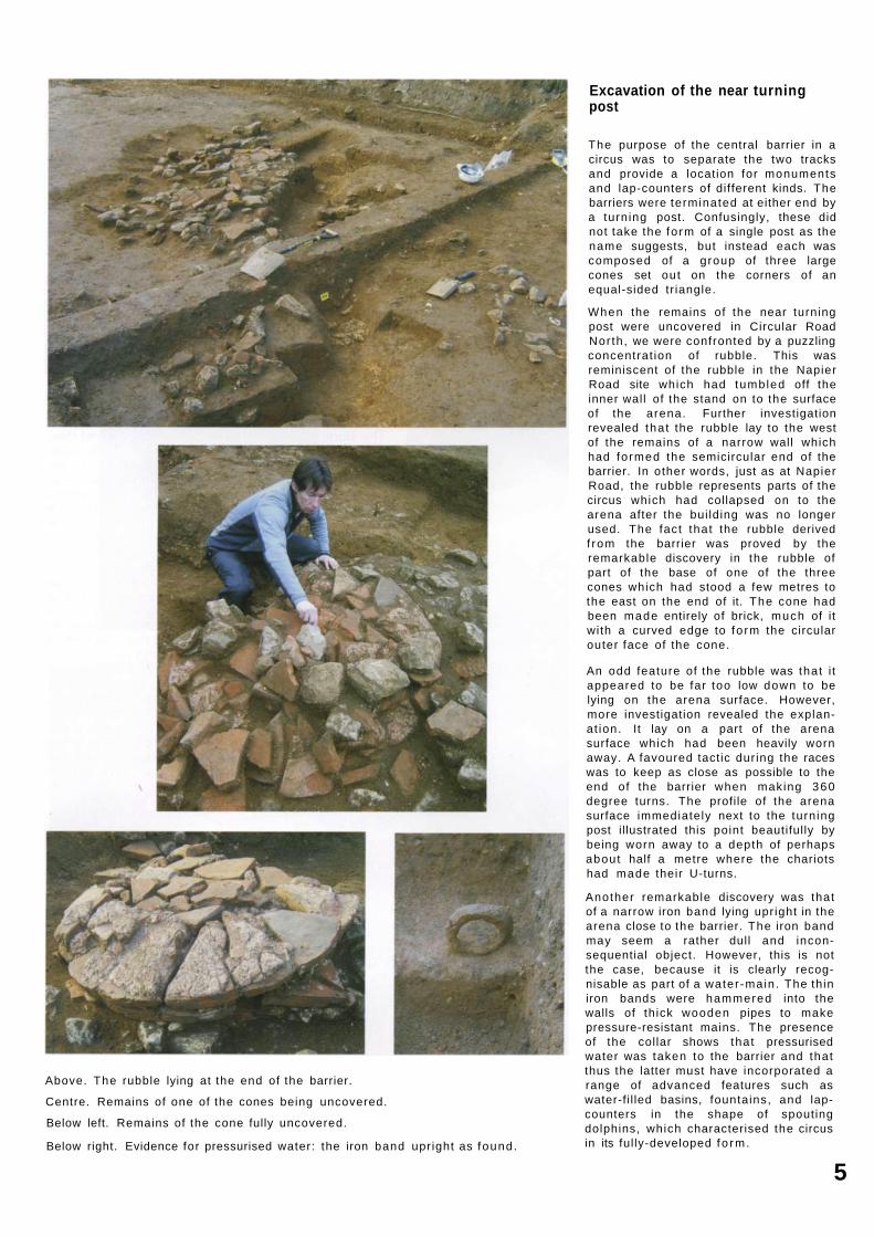
A l though the large-scale redevelopment of the Garrison has provided several valuable opportunit ies to investigate the circus, the site of the starting gates lies in a garden which is to be left un-developed. This is of course a good th ing archaeological ly because it means that the remains of the gates will not be disturbed. However, if we are to understand the circus properly, we need to f ind out about the gates since they were such an impor tant part of the circus. We need to know exactly where they stood, how many there were, and what fo rm they took. Permission was therefore sought f rom Taylor Woodrow to carry out a small excavation in the garden of the Sergeant's Mess which they own and where nearly all of the remains of the starting gates lie. Twenty members of the Friends of CAT volunteered to help and worked over a three week period under the supervision of Laurie Driver and Emma Spurgeon to uncover the remains of two of the starting gates and part of the adjacent entrance into the arena.
Above. An enamel led horse harness f i t t ing found on the Napier Road site. It lay on the arena surface, within about a foot away f rom the stand. It seems possible f rom its location tha t the f i t t ing had been torn f rom the harness of a horse when the an imal coll ided with the inner wall of the stand. The f i t t ing is about 31 mm wide.
Below. Photograph by Crpl Richard Cave of the British Army. Reconstruction drawing by Peter Froste.

Excavation of the stand
The remains of the stand which were uncovered in Napier Road - the seating area in the circus - turned out to be the best we have yet seen in terms of preservation. In plan, the stand proved to be just as we have found it elsewhere - a narrow inner foundat ion and a much more substantial outer foundat ion made stronger with the addi t ion of buttresses along the outside. The purpose of the buttresses was to help counteract the outward pressure on the wall caused by the earth bank, seating, and spectators so that the wall would not topple outwards.
The seating would probably have been in the form of wooden benches arranged in tiers laid directly on an earth bank contained by the inner and outer walls of the stand.
The width of the stand is of considerable interest since this is a key considerat ion when estimating the likely capacity of the bui lding. Even so, it is a tricky business. If, as seems likely, spectators sat on every tier and shared their space with the feet of the spectators behind them, then the circus could have held up to about 15,000 or so people. If the spectators only occupied every other tier, then the total would have been just over half that number.
An interesting aspect of the Napier Road excavation was the evidence it provided for the end of the circus. The outer wall appears to have been deliberately dismant led in the later Roman period so tha t the bui lding materials could be salvaged for reuse elsewhere. This was indicated by a layer of crushed mortar and chips of stone left by the stone 'robbers' a long the outside of the circus. There was no equivalent layer of demol i t ion debris next to the inner wall . Instead large pieces of stone lay along the edge of the arena where they had fal len off the top of the inner wall . This shows that the inner wall had not been dismantled like the outer one but had been left to decay slowly. It's hard to explain why the two walls were treated differently, but perhaps it was thought that the inner wall contained too little stone to justify the salvage work.
Above: foundat ion of the outer wall of the stand viewed f rom the west. The large projection on the right side of the wall is the base of a long buttress on the exterior of the wal l .
Right: Napier Road after the road surface had been removed. Viewed f rom the east with conjectural profiles of the stand added. Photograph by Van Cols Ltd.
Above. The rubble lying at the end of the barrier.
Centre. Remains of one of the cones being uncovered.
Below left. Remains of the cone fully uncovered.
Below right. Evidence for pressurised water: the iron band upright as found.
Excavation of the near turning post
The purpose of the central barrier in a circus was to separate the two tracks and provide a location for monuments and lap-counters of different kinds. The barriers were terminated at either end by a turning post. Confusingly, these did not take the fo rm of a single post as the name suggests, but instead each was composed of a group of three large cones set out on the corners of an equal-sided tr iangle.
When the remains of the near turning post were uncovered in Circular Road Nor th , we were confronted by a puzzling concentrat ion of rubble. This was reminiscent of the rubble in the Napier Road site which had tumbled off the inner wall of the stand on to the surface of the arena. Further investigation revealed tha t the rubble lay to the west of the remains of a narrow wall which had formed the semicircular end of the barrier. In other words, just as at Napier Road, the rubble represents parts of the circus which had collapsed on to the arena after the bui lding was no longer used. The fact that the rubble derived f rom the barrier was proved by the remarkable discovery in the rubble of part of the base of one of the three cones which had stood a few metres to the east on the end of it. The cone had been made entirely of brick, much of it with a curved edge to fo rm the circular outer face of the cone.
An odd feature of the rubble was that i t appeared to be far too low down to be lying on the arena surface. However, more investigation revealed the explanat ion. It lay on a part of the arena surface which had been heavily worn away. A favoured tactic dur ing the races was to keep as close as possible to the end of the barrier when making 360 degree turns. The profile of the arena surface immediately next to the turning post illustrated this point beautifully by being worn away to a depth of perhaps about half a metre where the chariots had made their U-turns.
Another remarkable discovery was that of a narrow iron band lying upright in the arena close to the barrier. The iron band may seem a rather dull and inconsequential object. However, this is not the case, because it is clearly recognisable as part of a water-main. The thin iron bands were hammered into the walls of th ick wooden pipes to make pressure-resistant mains. The presence of the collar shows that pressurised water was taken to the barrier and that thus the latter must have incorporated a range of advanced features such as water-fi l led basins, fountains, and lap-counters in the shape of spouting dolphins, which characterised the circus in its ful ly-developed fo rm.
5

Excavation of the starting gates The starting gates proved to be better preserved than expected. The remains of two complete stalls were uncovered plus one side of the central entrance. The latter would have been f lanked on either side by an equal number of stalls which, in most circuses, was six to give a total of twelve in al l . A l though the total number of gates in the Colchester circus is yet to be established beyond any doubt , the size of the stalls and the width of the west end of the circus (all now known) neatly f it a full complement of twelve. Solid walls of stone separated each of the stalls. The stalls themselves were just wide enough to make sure that once inside the horses in a four-horse chariot could not turn around but had to face the direction of the race. The front of each of the gates would have been fitted with double doors. The magistrate who presided over the races and was responsible for starting each one sat in a special box above the entranceway. On his c o m m a n d , an assistant (also in the box) pulled a lever which operated a mechanism designed to ensure that all the doors opened simultaneously. Remains of the demol ished box lay on a thin gravelled surface in the entranceway where the presence of f ragments of roof ti le and painted plaster showed it to have been a well-built and nicely decorated room.
Philip Crummy
Above top: excavation in the garden of the Victorian Officers' Mess, later to become the Sergeants' Mess.
Left centre: the excavation of stalls 7 (left) and 8 (right) looking westwards. The chariots would have faced to the bot tom right in readiness for the start.
Left below: the remains of the roof and walls of the magistrate's box under excavation.
The excavation of the gates was a research project and therefore
not part of the main Garrison excavations. It was made possible by
a grant from the Essex Heritage Trust with additional funding
from the corporate friends of the Friends of the Colchester Archaeological Trust. (See inside cover for the names of the
corporate friends.) Permission to excavate in the garden was kindly
given by Taylor Woodrow. Most of the excavation was carried out
by volunteers from the Friends of the Colchester Archaeological
Trust. The excavation of the circus and burials (pp 10-13) is part
of the garrison excavation undertaken for Taylor Woodrow with
project management by RPS Planning.

Giant Roman chariot racing mosaic is completed!
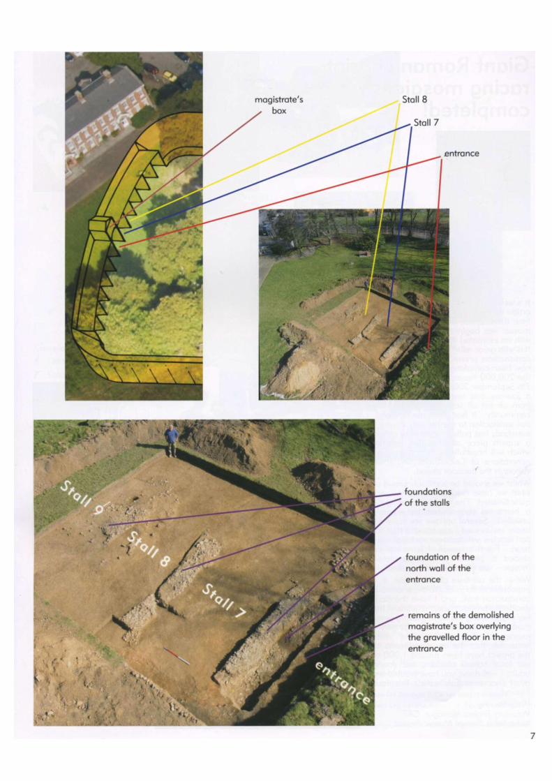
It is well over a year since I wrote my first article for the CAT magazine and at tha t t ime the first half of our 20 by 10 foot mosaic was beginning to take shape -with an estimated 60 ,000 tesserae laid. It is with great relief that I can report the construction phase of the project has now been completed. In fact the last of the 200 ,000 tesserae were laid on the 7th September 2006 . It has been quite a journey and involved many people f rom almost all segments of our local communi ty. It has given me t remendous satisfaction to see the way in which everybody has pulled together to create a superb piece of illustrative artwork which will hopefully be appreciated by generations of Colcestrians and town visitors in the decades ahead.
Whilst we should be justifiably proud of what we have created, the task is not quite f inished. The mosaic is wait ing for a home so that it can be properly unveiled. Several options are currently under review and I am hopeful that we can reach a satisfactory conclusion very soon. For this reason, I have not included a picture of the completed mosaic - you will need to be patient!
Within the confines of this article, it is impossible to do justice to the enormous construction task, and I have therefore decided to provide a short t imel ine of the key events along the way. Having never made a mosaic in my life, it was truly a journey of discovery, but we must remember tha t the key contributors to the project have been around 1,000 of our local school children and young adults - well done, you have created an other chapter in Colchester's illustrious history!
Peter Herring Voluntary Project Manager, CAT Abbeyfields Roman Mosaic Project
8
I would like to thank the fo l lowing people for their help and support w i th the project:
* The Heritage Lottery Fund (The Local Heritage Initiative) for their financial support
* Peter Froste for the artwork design and production
* Sue Cowans, Kevin Flower, Tessa Sagar, Chris Roberts, John Jones & all the staff at The Philip Morant School & College
* All the students of The Philip Morant School & College for their tremendous commitment in creating the majority of the mosaic and in particular the 2005/2006 Year 10 Art students who undertook the complex parts of the mosaic
* The pupils from Prettygate Infants & Junior Schools, Hamilton, Lexden, Home Farm and Gosbecks Primary Schools who helped to complete the mosaic
* Anne Schwegmann-Fielding for support, inspiration and advice
* DAG Construction of Stanway for providing the workshop foundation
* Stacey Flannegan of the Philip Morant Site Team for his work on keeping the workshop weatherproof and secure
* Glenn Jones for the supply and fitting of the workshop carpet
* Volunteers from the Friends of CAT who provided essential assistance in completing the mosaic - especially Brenda May, Margaret Gooderham and Alan Stokes
* Sara Green and Bella Pearce for their helping out in the workshop
* Sgt Bob Byers & Staff of MCTC 'D ' Company for their tremendous support in the key tasks of transporting the mosaic, joining the two halves and the fibre glass and reinforcing process
* Michael Swindells from the Mosaic Shop, Bath for his generous discounts
* The Dulux Decorator Centre, Colchester for the donation of materials
* Tile & Stone, Colchester for the generous discounts on grout mix
* The East of England Co-operative Society for keeping the students refreshed during the hot weather!
* Lexden Restorations for providing storage facilities for the finished mosaic
* Van Cols Creative Design & Photography for kindly photographing the finished mosaic
* HSS Hire for transport and the supply of equipment
* Adhere Industrial Tapes for storage facilities and materials
* Technical Resin Bonders Ltd for the supply of the reinforcing panels

Grave concerns: the cemeteries of Roman Colchester
In his magis te r ia l 1958 p u b l i c a t i o n
Roman Colchester, Rex Hu l l
suggested t h a t R o m a n Colchester
had seven separate cemeter ies .
A r c h a e o l o g i c a l w o r k since t h a t t i m e
has b r o u g h t to l ight a very large
n u m b e r o f bur ia ls , no tab ly a t Bu t t
Road a n d on t h e Colchester
Garr ison site. H o w has o u r
percept ion o f the cemeter ies
c h a n g e d over the h a l f - c e n t u r y since
Hul l 's pub l ica t ion?
By Roman law, adults could not be buried in a city or town. So, by necessity, burials had to be located outside the city walls. In Hull 's t ime, it was thought that the burials were loosely grouped into what we would now call 'cemeteries', and Hull recognised seven of these around Colchester - the Lexden, West, Abbey Field, Butt Road, Union (ie St Mary's), North and North-east cemet-eries. The discovery of many more Roman burials since the 1950s has shown the situation was not quite so simple.
One change since Hull 's t ime is the realisation that the burials were placed in discrete plots whose boundaries were defined by ditches, or by the side of an adjacent road or track. It had been known for some t ime that a favourite location for Roman burials was a longside main roads, particularly as they approached the town gates. In Colchester, the London Road was f lanked by impressive monuments such as the Colchester Royal G rammar School temple- tomb (Colchester Archaeologist 19), by lesser tombs such as those marked by the Longinus and Facilis tombstones, and by the Colchester Sphinx. It has been more of a surprise that , even when the roads turned away f rom the town into areas of fa rmland, the sides of those semi-rural or rural trackways were still favourite places for burial. A good example is a
10

major trackway which has only come to light in recent years, f lanking the 2004-5 excavations to the south of the Butt Road 'Pay & Display' car park and then running south across Abbey Field. On the 2004-5 sites, only the east side of the track fell within the excavated areas, but over 350 burials crowded up to this boundary. The existence of these ditched cemetery plots first became evident on the site of the Butt Road police station, where major excavations took place in the 1970s and 1980s before the police station was built. Here, a small 2nd- to 3rd-century, di tched cremation and inhumat ion cemetery was replaced by a large, di tched inhumat ion cemetery in the late 3rd and 4th centuries. Evidence of similar burial plots was seen in 2007 in test trenches on the Butt Road 'Pay & Display' car park site, where the absence of burials in the middle of the site implies an empty plot in between two separate cemeteries, the southern one being the cemetery excavated in 2004 , and the northern one a new discovery whose southern extent is def ined by a di tch.
Intriguingly, there may be a chrono-logical theme to these cemetery plots. Cremation cemeteries of the 1st and 2nd centuries AD tend to be located away f rom the Roman town, whereas inhumat ion burials of the 3rd and 4th centuries tend to be closer. This is

demonstrated by the three sites already ment ioned - there were 73 cremations and no inhumations on the sports pitch site, and there were 90 cremations and 207 inhumat ions on the 2 0 0 4 excavation site. The trend is conf i rmed by the Butt Road Police Station site, where a small 3rd-century cremat ion cemetery was fol lowed by a late 3rd- and 4 th-century cemetery with 734 inhumat ions.
Why is this so? By around AD 300 , Roman Colchester was shrinking. There is clear evidence f rom excavations for the demol i t ion of town houses and even areas of suburbs beyond the walls. This left vacant plots, many of which reverted to agriculture. Perhaps these vacant plots encouraged the establ ishment of the later inhumat ion cemeteries closer to the town.
Since Hull 's day, we have developed a greater understanding of the huge variety of burial types. Careful excavation on cemetery sites reveals burnt patches of earth mixed up with cremated bone. These are 'pyre sites', where the cremation fire took place. One particularly interesting type of pyre site is the ful l-body cremat ion or bustum (plural busta). These have been recognised at Handford House (Colchester Archaeologist 17) and at the Garrison. In well-preserved busta, the cremated body can drop, more or less in its articulated position, into an open slot under the pyre where the remains were left to rest.
The whole issue of burial and burial rites has become much more complex since Hull 's t ime. We now realise tha t burials were not simply inhumat ions or c remations, but included a range of apparently odd types of burials, such as cremated bone placed into a hole without a cremation vessel, or perhaps cremated bone mixed up with a few potsherds. It seems clear that what went into a burial depended on how much of the remains were collected f rom the pyre site. Was the thoroughness of this collection a reflection of t radi t ion and the ethnic origin of the mourners? Did rich people's burials contain many pots and carefully collected cremated bone, and did poor people have a budget burial? Of course, we may never know the answers to any of these questions. That is the fascination of archaeology, the more we dig up, the more questions we have to ask... .
Howard Brooks
Pictured above and on the previous pages excavating Roman graves: Cat Bell, Brian Hurrell, Nigel Rayner and Mariusz Gorniak.
12

Making up for the next life A strange-looking two-part object found in
one of the burials at the Garrison site was
the Roman equivalent of the modern
powder compact. Women ground their
cosmetics in one part of it and applied the
product to their bodies with the other. Nina
Crummy explains how these items were
used and describes the ' look' that might
have been achieved as a result.
The objects buried with the dead can be among the most informative things an archaeologist can study, but they can also pose as many questions as they answer. The objects most often found in Roman graves are jewellery, c lothing, a pot fi l led with food or drink for the journey to the Underwor ld, a lamp to light the way or coins to pay the ferryman. Other things are less commonly recovered, and one woman 's burial f rom Roman Colchester, excavated in advance of the Abbey Field redevelopment, contained a cosmetic set, an object which is not especially rare in itself but is unusual as a grave deposit.
Cosmetic sets are copper-al loy two-piece objects, a crescentic pestle and a grooved mortar. They come in two main forms and can have decorative terminals, with no two sets being com-pletely alike. Lumps of coloured mineral would have been placed into the mortar
and ground to a powder by the pestle, then appl ied to the face, or perhaps the body. They are peculiar to Roman Britain, with only one certain f ind f rom France, found , oddly enough, near the entrance to the Channel Tunnel .
There are many references in con-temporary l iterature to the make-up used in Roman Italy. Most favoured was a white foundat ion , made either f rom white lead or the white excrement of crocodiles, with rouge and kohl used for colouring the cheeks and accentuat ing the eyes. The total effect would have been quite unsubtle, more like exaggerated stage make-up than the natural effect a imed for these days. Stone palettes were used for gr inding up cosmetics and other beauty prep-arations, and these objects are found in Britain as well as on the cont inent.
A l though many of the citizens of Britain might have fol lowed Roman fashions for
paint ing the face, there are hints that we were always just that little bit different. Caesar, Ovid, Mart ia l and Pliny are among the Roman writers who describe the British as paint ing their bodies, and it is generally understood tha t the specific Latin words they used meant that the Britons favoured a dye made f rom woad , Isatis t inctor ia. This plant produces a blue colour, much used by dyers of textiles, but if old dye is used or if the skin is over-exposed to the substance, i t can turn black. This may have often happened, as Pliny describes how the wives of Britons, and their daughters-in- law, looked like Ethiopians after staining their bodies with a plant extract.
Unfortunately, so far there is no evi-dence about what sort of cosmetics were ground up in the British metal sets, as no trace of any mineral has yet been found preserved inside a mortar. It is tempt ing to imagine tha t the woman buried at Abbey Field, who took her cosmetic set with her to the grave so that she could cont inue to look her best in the next life, may have been a Briton who had cont inued the practice of her ancestors, but she might equally well have used Roman-style cosmetics, gr inding them up in a handy British metal mortar instead of on a stone palette.
The cosmetic set was found tucked under the skull of an adult . From the way the two parts lay in the ground, it looks as if they had been loosely held together by something like a piece of string or leather (now decayed completely away) threaded through the loops.

Two arches or one?
T h e remains o f t h e R o m a n g a t e a t
H e a d Ga te are surpr is ingly wel l
preserved a n d lie only a f o o t or so
be low t h e m o d e r n r o a d . A recent
t r e n c h f o r new BT d u c t i n g a l o n g
Head Street prov ided a rare
o p p o r t u n i t y t o f i n d o u t m o r e a b o u t
t h e or ig ina l a p p e a r a n c e o f t h e g a t e .
Head Gate takes its name f rom the gate which used to stand at the Crouch Street end of Head Street, this having been the chief or head gate of the walled medieval town. Originally, the Head Gate was one of six gates leading into the Roman town of which the Balkerne Gate was the most important (perhaps along with East Gate on the opposite side of town) . The closure of the Balkerne Gate in the late Roman period meant that the main route into town f rom London and the west was through the Head Gate, hence its name.
Roman gates in general varied considerably in plan. The largest, like the Balkerne Gate, consisted of a pair of archways f lanked on either side by a single smaller archway for pedestrians. Some gates had just one main archway rather than two and some, like Duncan's gate in Colchester, consisted of just a single archway with no separate provision for pedestrians at al l .
Head Gate was demol ished in 1753 leaving us with little reliable informat ion about its appearance apart f rom an indicative sketch on the Colchester town
plan which was published just a few years earlier in Morant 's History of Colchester and a similar sketch on Speed's map of Colchester which appeared in 1610. Both show a gate with just a single arch. Other evidence for the gate only having a single arch is to be found in the records of the Siege of Colchester where Lord Capel, one of the royalist generals, is said to have fastened the gate shut with his cane.
Opportunit ies to investigate the site of the gate have been very rare in the past which is not surprising considering that its remains lie under one of the busiest roads in the town. In 1988, the Council replaced the pavement surfaces a long Sir Isaac's Walk and into Head Street. The remains of the gate were exposed because they turned out to be within about a foot and a half of the modern street level. This was the first real opportuni ty to examine the gate and the results of this work were described in The Colchester Archaeologist for that year (no 2) . A l though the investigations were very l imited, it did seem as if the drawings in Moran t and Speed were
misleading and that the gate originally was of double-arch fo rm.
In 2006 , BT needed to lay some major duct ing along the length of Head Street and beyond. The contractors, Lowery Ltd, commissioned the Trust to carry out a watching brief dur ing their work because of the archaeological sensitivity of the area. Fortunately Don Shimmin, who had carried out the recording work in 1988, was on hand to take up the chal lenge once aga in .
A problem with work of this kind is that we can never know beforehand how much survives under the streets because so much has been destroyed with the laying of services and drains of various kinds in the past. Work in Head Street started at the north end and , f rom the outset, the watching brief proved very rewarding with the exposure of various stretches of Roman foundat ions along the east side of the street.
When the trenching reached the site of the gate, i t became clear that our luck was in because masonry survived not far below the modern ground level. From
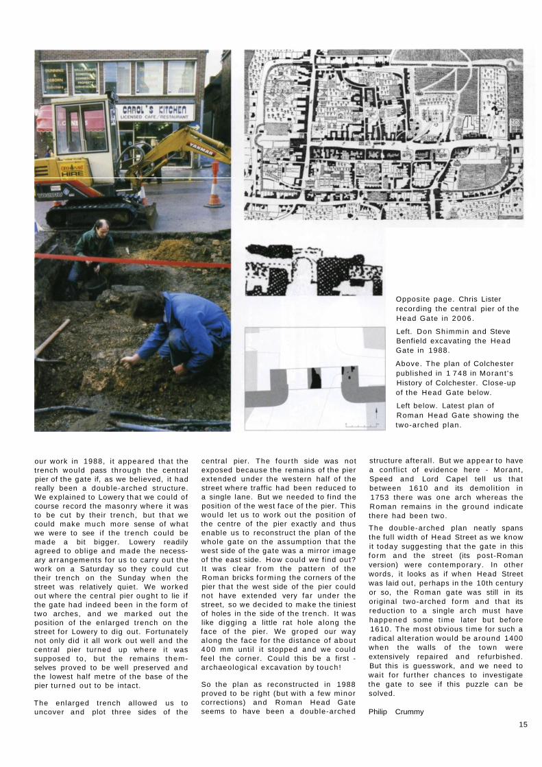
Opposite page. Chris Lister recording the central pier of the Head Gate in 2006 .
Left. Don Shimmin and Steve Benfield excavating the Head Gate in 1988.
Above. The plan of Colchester published in 1 748 in Morant 's History of Colchester. Close-up of the Head Gate below.
Left below. Latest plan of Roman Head Gate showing the two-arched plan.
our work in 1988, i t appeared that the trench would pass through the central pier of the gate if, as we believed, it had really been a double-arched structure. We explained to Lowery that we could of course record the masonry where it was to be cut by their t rench, but tha t we could make much more sense of what we were to see if the trench could be made a bit bigger. Lowery readily agreed to obl ige and made the necessary arrangements for us to carry out the work on a Saturday so they could cut their t rench on the Sunday when the street was relatively quiet. We worked out where the central pier ought to lie if the gate had indeed been in the form of two arches, and we marked out the position of the enlarged trench on the street for Lowery to dig out. Fortunately not only did it all work out well and the central pier turned up where it was supposed to , but the remains them-selves proved to be well preserved and the lowest half metre of the base of the pier turned out to be intact.
The enlarged trench al lowed us to uncover and plot three sides of the
central pier. The four th side was not exposed because the remains of the pier extended under the western half of the street where traffic had been reduced to a single lane. But we needed to f ind the position of the west face of the pier. This would let us to work out the position of the centre of the pier exactly and thus enable us to reconstruct the plan of the whole gate on the assumption that the west side of the gate was a mirror image of the east side. How could we f ind out? It was clear f rom the pattern of the Roman bricks forming the corners of the pier that the west side of the pier could not have extended very far under the street, so we decided to make the tiniest of holes in the side of the t rench. It was like d igging a little rat hole a long the face of the pier. We groped our way along the face for the distance of about 400 mm until i t stopped and we could feel the corner. Could this be a first -archaeological excavation by touch!
So the plan as reconstructed in 1988 proved to be right (but with a few minor corrections) and Roman Head Gate seems to have been a double-arched
structure afteral l . But we appear to have a confl ict of evidence here - Morant , Speed and Lord Capel tell us that between 1610 and its demol i t ion in 1753 there was one arch whereas the Roman remains in the ground indicate there had been two.
The double-arched plan neatly spans the ful l width of Head Street as we know it today suggesting that the gate in this fo rm and the street (its post-Roman version) were contemporary. In other words, it looks as if when Head Street was laid out, perhaps in the 10th century or so, the Roman gate was still in its original two-arched form and that its reduct ion to a single arch must have happened some t ime later but before 1610. The most obvious t ime for such a radical al terat ion would be around 1400 when the walls of the town were extensively repaired and refurbished. But this is guesswork, and we need to wait for further chances to investigate the gate to see if this puzzle can be solved.
Philip Crummy
15
Roman archaeology
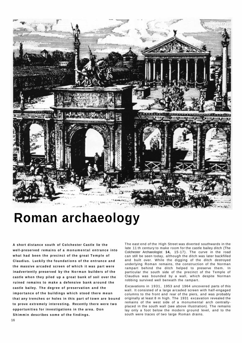
A shor t d i s t a n c e s o u t h of C o l c h e s t e r Cast le lie t h e
we l l -p reserved r e m a i n s o f a m o n u m e n t a l e n t r a n c e i n t o
w h a t h a d b e e n t h e p r e c i n c t o f t h e g r e a t T e m p l e o f
C l a u d i u s . Lucki ly t h e f o u n d a t i o n s o f t h e e n t r a n c e a n d
t h e massive a r c a d e d screen o f w h i c h i t w a s p a r t w e r e
inadver ten t ly preserved b y t h e N o r m a n bu i lders o f t h e
cast le w h e n t h e y p i led up a g r e a t b a n k o f soil over t h e
r u i n e d r e m a i n s t o m a k e a de fens ive b a n k a r o u n d t h e
cast le bai ley. T h e d e g r e e o f p reserva t ion a n d t h e
i m p o r t a n c e o f t h e b u i l d i n g s w h i c h s t o o d t h e r e m e a n
t h a t a n y t r e n c h e s o r holes i n th is p a r t o f t o w n a r e b o u n d
t o prove e x t r e m e l y i n t e r e s t i n g . Recent ly t h e r e w e r e t w o
o p p o r t u n i t i e s f o r inves t iga t ions i n t h e a r e a . D o n
S h i m m i n descr ibes s o m e o f t h e f i n d i n g s .
16
The east end of the High Street was diverted southwards in the late 11 th century to make room for the castle bailey ditch (The Colchester Archaeologist 14, 15-17). The curve in the road can still be seen today, a l though the ditch was later backfilled and built over. Whi le the d igging of the ditch destroyed underlying Roman remains, the construct ion of the Norman rampart behind the ditch helped to preserve them. In particular the south side of the precinct of the Temple of Claudius was bounded by a wal l , which despite Norman robbing survived well beneath the rampart .
Excavations in 1 9 3 1 , 1953 and 1964 uncovered parts of this wal l . It consisted of a large arcaded screen with half-engaged columns to the front and rear of the piers, and was probably originally at least 8 m high. The 1931 excavation revealed the remains of the west side of a monumenta l arch centrally-placed in the south wall (see above i l lustration). The remains lay only a foot below the modern ground level, and to the south were traces of two large Roman drains.

In 2006 it was possible to examine parts of this area again on a small scale. On the east side of the narrow modern street known as Crowther's Entry (after a previous owner), several evaluation trenches were dug in advance of a proposed redevelopment. These revealed a large stone-and-mortar foundat ion, 1.6 m below the modern ground level. The south face of the foundat ion was uncovered, a l though it was not possible to locate the northern edge. This was probably part of the foundat ion for the arch where the carriageway passed under it.
The monumenta l arch was about 8 m wide and was faced with tufa. This easily-worked stone was probably brought by sea from quarries near the the Hampshire coast. Across the f ront of the arch it is likely that there was an inscription, perhaps recording Claudius' role in the conquest of Britain. Evidence from elsewhere suggests tha t the Roman circus at Colchester was closely linked to the Imperial Cult (emperor worship), and circuses and temples were sometimes part of the same complex as at Tarragona in Spain. A l though in Colchester the circus and the Temple of Claudius were some 700 m apart, on race days a procession of priests and officials probably passed under the arch on their way to the circus (The Colchester Archaeologist, 18, 14).
Further Roman remains were uncovered 0.9 m below the modern ground level on the west side of Crowther's Entry in December 2006 during rebuilding work. The north side of a well-preserved drain was traced for 7.5 m. It was constructed of Roman brick set in a hard pinkish mortar (opus signinum). The drain probably lay between the precinct wall and an east-west street, which had been destroyed when the Castle Bailey ditch was dug.
The recent work has enabled the location and depth of the Roman arch and nearby remains to be plotted more accurately, and thus the impact of any future redevelopment can be assessed with more conf idence.
Above left. Artist's impression (Peter Froste) of the monumenta l arch which led into the precinct of the Temple of Claudius.
Above. The 2006 excavation in progress in Crowther's Entry.
Above right. The Roman drain as uncovered late in 2006 in a yard off Crowther's Entry. Only the southern half of the drain is exposed. The vertical face visible in the photograph would have been buried in Roman times when the drain was in use.
Right. Conjectural reconstruction of a cross section through the drain.
17

Roman remains -new views Howard Brooks
Redevelopment work in Colchester sometimes opens up views which have never been seen before. The demol i t ion of the Mercury Flats has al lowed the unusual view shown below right of the Mercury Theatre. Appropriately, the f igure of Mercury himself is seen on the corner of the theatre bui lding.
The Mercury Flats was part of the Balkerne Gardens residential home. The home occupies a prime piece of the Roman town, situated immediately north east of the Balkerne Gate, in Insulas 17a and 17b of the Roman town. A l though there has never been the large-scale excavation which the site deserves, various watching briefs and trial trenches over recent decades have brought to light f ragments of the Roman buildings which once occupied the site. Roman coin hoards were found here in 1965 and 1977.
Plans for redevelopment tr iggered a small evaluation in 2005 , and a watching brief in 2006 on the new building and its drains. As expected, various Roman wall lines, f loors, and gravel surfaces have come to light. Loose finds were plentiful, and included a significant quantity of late Roman pottery. The new scheme was designed so that the disturbance to the underlying archeological remains would be as l imited as possible. The result is that the interesting and well-preserved Roman remains on the site survive for future generations to examine.
The recording and investigations were funded by the Balkerne Gardens Trust. The architects who commissioned the work were Stanley Bragg.
Above right: Jumbo looms over the Balkerne Gardens residential home. The trenches visible are new drain lines for the rebuilt Mercury Flats.
Right: Will Clarke recording Roman strata in the builder's trenches with Mercury just visible in the background perched on the Mercury Theatre.

The lost church of the Crossed Friars
Crouch Street is a relat ively
quiet street t o d a y . But i t was
not so long a g o t h a t i t was a t
one end of t h e road be tween
Colchester a n d L o n d o n . For
travel lers f r o m t h a t g r e a t
ci ty, a l a n d m a r k at t h e end
o f the i r journa l w o u l d been
the c h u r c h o f t h e f r i a ry o f t h e
Crossed Friars. Stephen
Benfield descr ibes h o w
recent w o r k on a b u i l d i n g site
has led to the discovery of
the long- los t c h u r c h .
Standing outside shops in Crouch Street and looking across the road, there is not usually much to see. However, I as write this account, hoardings where Cash Converters used to be, proclaim the imminent arrival of a new development of flats. Above this you are drawn to look up at the crane towering over the site. By coincidence, six hundred years ago in the Middle Ages, people passing along what is now Crouch Street would also have been drawn to look up at almost exactly that same spot. There, reaching up to about the top of the Birkett Long's offices, they would have been gazing up at the tower of the church of the Crossed Friars.
It seems remarkable that, of the four medieval religious houses founded in Colchester, little today remains to be seen. The ruined of part of the church of St Botolph's Priory can still be visited. There is the restored gatehouse of St
John's Abbey, a l though nothing of the abbey itself remains. The area of Grey Friars is still commemora ted in the name of Grey Friars College (but see pp 24-5 below). Crossed Friars is probably the most obscure of all these houses and is now all but invisible in the modern town . However, there is one lasting memor ia l of the house of the Crossed Friars, a l though this is not immediately obvious, the name Crouch Street. Crouch is an old word for cross, and the Crossed Friars were also known as the Crouched Friars. Crouch Street is in effect Cross Street and is named after the friary that once stood there. Excavation and recording by the Trust on behalf of Bellway Homes, dur ing the redevelopment of the former Cash Converters site has al lowed part of the remains of the Crossed Friars church to be identif ied. In conjunct ion with earlier excavations, much of the ground plan of the church can now be pieced together.
Distant b re th ren : crouched friars in Crouched Friars, London.
The Crossed Friars and Colchester The name, Crutched, Crouched or Crossed Friars comes f rom the physical appearance of the brothers. Each of the friars carried a wooden staff that had a cross on the top of it, and each had a red cross of cloth sewn on to his habit. The habit was originally brown or black in colour, but was later changed to blue. They were a Mend icant order, which means tha t they begged and relied on chari table donat ions for their income and support. Their main concern was caring for the poor and needy, helping to look after both body and soul.
The origin of the Crossed Friars is un-certain. They c la imed a middle-eastern foundat ion of the 1 st century AD , but
19

were later reconstituted in 4 th century Jerusalem. They were in Italy in the 12th century when Pope Alexander III gave them a constitution and a rule of life similar to that of the better known August inian order. A rule is a guide in the form of a set of ideals of how to live a religious life, of which the rule of St Augustine, written in about AD 400 , is one of the earliest. In England, the Crossed Friars first appear at the synod of the diocese of Rochester in 1244. They may have come to Colchester as early as the fol lowing year, a l though the first secure record of the order in Colchester refers to 1251 . At that t ime they occupied a hospital and chapel buildings at Crouch Street, established for them by the Lords of Stanway. The Crossed Friars were not a large order in England, and a small number of houses were established in this country at Colchester, London, Reigate, Oxford, York, Great Wel tham and Barnham (Suffolk), Wotton-under-Edge (Gloucestershire), Brackley (Nor thamptonshire) and Kildale (Yorkshire).
By 1401 the friary at Colchester had fal len on hard t imes, and parts of the church (the nave, chancel and bell tower) were in need of repair. It may have been at about this t ime, and on account of poverty, that the Crossed
Friars lost control of the premises as it is recorded as being at this t ime a free chapel or hospital. The poverty of the Colchester house can be contrasted with the more aff luent London friary established in 1249 at Tower Hil l . This lay directly at the other end of the road between London and Colchester (the Colchester friary being at the Colchester end). The locat ion of the London house is still called Crutched Friars. In 1342 the London Friars were seeking accom-modat ion for thirteen of their brothers to study at Oxford University, and in 1350 were also bui lding a new chapel . This wealth appears to have been achieved by slow acquisitions of grants and purchases of property. However, it seems that not all of their wealth was being accrued above board. There are records of 1349 of London friars involved wi th robbery and in 1391 of abett ing a man who had stolen property f rom the house of the Bishop of Bath and Wells. At Colchester f inancial help was obtained in 1403 f rom the Bishop of London who helped to revive the fortunes of the religious establishment. Incidentally this also led to the disclosure of an interesting fact about the possessions of the friary. At that t ime a list of their possessions was drawn up and among these was a relic believed to
Excavations in progress uncovering the tops of the church foundat ions.
be a piece of wood f rom the holy cross. However, we know that the Crossed Friars were no longer in control of the establishment at that t ime and in 1407 a guild of St Helen was founded in the church. However, in 1496 the Crossed Friars, after producing papal bulls and other evidence, were able to reclaim the church and hospital. At about this t ime, in the later 15th century, it was recorded tha t there were two chapels and a hospital on the site. In 1526 an man accused of murder, Wi l l iam Gilbank, c la imed sanctuary in the church. He was sheltered in the choir near the high alter and would not be surrendered by the friars.
However, by the early 16th century the days of the great medieval religious houses, large and smal l , were num-bered. Most were to fall and their property to be sold off, dur ing the dissolution. The weal th of many made them attractive targets for the king. Their despised reputations for good living and loss of religious zeal made them easy targets - one only has to think of the well-fed fr iar in Robin Hood. This
20

in many ways, rather than the death of Richard III at Bosworth in 1485, was the real end of medieval England. In 1538 the buildings and estates of the Crossed Friars were granted to a Sir Thomas Audley. It was shortly after this t ime that illustrations representing what survived of Crouched Friars first appear on maps, the earliest of these being in 1610. In 1637 Crouched Friars was purchased by Sir Harbott le Grimstone, member of Parl iament for Colchester. Sir Harbott le converted the site into a house and it is probable that any surviving parts of the church would have been demol ished at this t ime. The church would have had little part to play in comfor table secular dwellings that usually made more use of ancillary buildings of former religious houses. However, Sir Harbott le was not able to enjoy his possession for very long. In 1648 Royalist soldiers occupied the house during the siege. It was bombarded and assaulted by the Par-l iamentarian army forcing out the Royalists who in retreat set it ablaze, destroying the house. In 1700 a work-house was established on the site and it is recorded that this bui lding was mostly of a new construct ion.
The church of the Crossed Friars In present day Crouch Street, the construction method being used for the new flats, as with many modern buildings, consists of deep concrete piles joined together by concrete ground beams. Preparation for this work involved the clearing away of the last remains of the Cash Converters bui lding and the reduction of the ground level over parts of the site. This was so tha t a layer of hard standing could be laid for the large piling machine to operate on without sinking into the ground. The construction process was designed to minimise the impact on the underlying remains. Even so, it was dur ing the reduction of the ground level that the Trust was able to record sections of medieval foundat ion exposed on the west side of the site. As the machine worked rapidly across the site f rom the Southway side towards Crouch Street, a small team f rom the Trust was soon hard at work chasing the surviving sections of the foundat ions. These consisted of two parts. The tops were mortared stone and tile rubble, wi th facing stones in some places. The lower part was thin layers of rammed earth, alternating with th in layers of either mortar or gravel, in the foundat ion trench below. This lower part was presumably a cost cutt ing measure,
The remains of the base of a t i led f loor in the church. Loose tiles exactly match the impressions of missing tiles in the mortar base of the floor.
saving on the expense of entirely mortared foundat ions.
The ground plan could not be completely recovered because the digging of various trenches coupled with various other groundworks over the years had damaged parts of the site. However, various gaps could be fil led in using one's imaginat ion so as to try to understand the plan. Initially it seemed that there might be several buildings, and that understanding the plan f rom the f ragments might prove diff icult. Then , about the middle of the west side of the site, two massive square foundat ion bases appeared. Unlike the other foundat ions these were constructed entirely of mortared rubble and must have been built to support a great weight Assuming that these large bases were a symmetrical pair wi thin a bui lding, the other wall foundat ions could be viewed in relation to t hem. Also, the current archaeological work is not the first t ime that the Trust has been able to investigate the site of the religious house of the Crossed Friars. In 1988, Don Shimmin led a small rescue excavation on the site of what is now Birkett Long, solicitors. This revealed parts of a medieval bui ld ing, including two large parallel wall foundat ions
extending east to west across that site. Bringing all this informat ion together, it was at this point that the archaeological penny dropped. What we were un-covering was the east end of a large medieval church bui lding, and the large foundat ion bases were the southeast and northeast supports of a tower above the crossing. To the north and south of this were the remains of the two transepts and to the east we had the south wall of the chancel . Two gaps in the foundat ions, thought to indicate that the foundat ions were of separate buildings, could now be seen to be the site of doorways. These doors must have been planned when the church found-ations were built. The large foundat ions Don Shimmin had recorded in 1988 f i t ted in perfectly with this interpretat ion: these were clearly parts of the walls of the nave. This means that the remains of the west end of the church must be lie somewhere beneath what is now Tesco. A number of other sections of found-at ion recorded since, indicate that there was probably a chapel at tached to the north side of the chancel . Also there are indications of other buildings to the north-east of the main church. A foundat ion , running under the Dulux shop, at the northeast corner of the site,
21

could be part of a building or part of a boundary wall that is indicated on the early maps.
The site of the church had been reduced in the past to the tops of the medieval foundations with the result that very little of the f loor levels now survived. However, not quite everything of the later medieval layers had gone. One small area of mortar was uncovered in the south transept that had the curious imprint of rough squares in its surface. This was thought possibly to be render collapsed f rom a wall or vault. However, as so often in archaeology, the true identity of this only became apparent slightly later. Many churches have areas of tiled f looring, often set in a d iamond pattern in relation to the orientat ion of the church. This was exactly the al ignment here with the imprint of the squares. Later some plain glazed tiles were found which exactly f i t ted the imprints, al though these were not necessarily the original tiles f rom this f loor. This shows that the f loor of the south transept was made of tiles, presumably glazed, set in a d iamond pattern. This f ragment of f loor had survived as, fortunately, it must have sunk below the level of the rest of the f loor surface before that was removed. Areas of probable mortar f loor, but wi thout any tile impressions, were
uncovered sunk into an earlier feature in the north transept. Also there were two phases of plain mortar f loor ing in the chancel . The f loor level in the chancel must either have been lower than that in the area of the crossing and transepts or possibly the floors there represent an earlier phase of a bui lding pre-dating the main church.
As construct ion work progressed, machine excavation began again for the concrete ground-beams. On the south of the site, this revealed little of interest, but once work began on the west side of the site, in the area of the church bui ld ing, everything changed. Almost immediately human bones began to appear. I t soon became apparent that near the surface most of this bone had been disturbed and was loose in the backfil l of other features, but lower down there were art iculated bones that were in situ burials. The plan of the new bui lding meant that two areas on the west of the site could be investigated, and in all about 60 burials were recorded f rom these areas. All the burials were oriented east to west, with the head at the west end of the grave, and there were no indications of any coffins or of objects placed in the graves. The burials were set out in north-south rows with some cutt ing earlier ones. In many cases where one cut another, the
Above. Conjectural impression of the parts of the church found on the excavation site. View seen f rom the north side of Crouch Street with Birkett Long's to the immediate right.
Right. Plan of the church. North is to the bot tom of the plan to match the or ientat ion of the photograph above.
Right below. High level photograph of the site by Van-Cols Ltd showing the remains of the church. Taken f rom the north. The orientat ion matches the plan and photograph above.
disturbed bones were re-buried loose to one side of the later burial. All of the burials were found in the transepts or in between the north transept and the Crouch Street f rontage. None were discovered south of the church or east of the transepts.
Don had found similar closely-packed burials on the 1988 site (Birkett Long) just to the north of foundat ions that we now realise fo rmed part of the nave. Also there is a record f rom 1928 of the discovery of many burials in the area of the nave itself. As yet there is no specialist report on the bones f rom the
22

2007 excavation. However, it is obvious from the size of some of the skeletons that not all of the burials are adults as some are so small that they must have been children. Clearly these are not the remains of brothers of the friary. In 1402 a grant was made to the chapel for burial of the inhabitants of the neigh-bouring parts of Crouch Street and Maldon Lane, and this probably explains the presence of chi ldren. But even so, it is clearly not a straightforward matter to establish who was buried where. There may for example be burials associated with the hospital and chapel which predated the friary. Given this, the archaeological development of the site is likely to have been quite complicated, and many questions remain unanswered. However, the lost church of the Crossed Friars has now been found and we now know significantly more about what was once an obscure monastic site in the town.
The excavations on the site of Crouched Friars were carried out on behalf of Bellway Homes who funded the work.
23

The lost friary of Grey Friars There were two friaries in medieval Colchester:
Grey Friars which, not surprisingly, was where
Grey Friars College of Adult Education now
stands, and Crouched Friars, which stood on
the south side of Crouch Street. Not much is
known about either of them, and opportunities
for site investigations are l imited. So it was
quite a coincidence to f ind ourselves working
on the sites of both establishments almost at
the same t ime.
Grey friars fol lowed the rule of St Francis of Assisi, and they wore a grey tunic with a white cord (hence their name) . By the t ime St Francis died in 1226, the order had spread f rom Italy to all over Europe including Britain.
The friary at Colchester was founded in the early 13th century sometime before 1237. In c o m m o n with the other monastic institutions in England, it was closed in the early 16th century and the land and buildings were confiscated and disposed of. By this stage, the friary lands had been extended to include all of the north-east corner of the walled area of the town. The property was bounded on the north and east sides by the town wal l , on the south side by the street later known as Friar Street (now the eastern end of the High Street), and the west side by the castle lands.
The friary buildings gradually dis-appeared so that by the late 18th
century, nothing of the friary survived above ground. Unfortunately records are sparse. However, it is clear that the friary had included a church, an infirmary, a hall , some lodgings, a ki tchen, a bakery, a brewery, gardens, a gatehouse, a precinct wall a long the south side of the friary, and at least two fish ponds.
Little is known about the layout of the buildings, and until recently the exact position of the church and the main friary buildings is uncertain other than the fact that the complex lay somewhere north of the High Street f rontage. However, there were some clues, and the best of these is a sketch drawn by Wi l l iam Stukeley in 1718. Stukeley is a wel l -known ant iquar ian who travelled the country drawing famous historical buildings and other landmarks. In Colchester, he also sketched the castle, St Botolph's Priory and the earthworks
on Lexden heath. His sketch of the Grey Friars shows a line of ruined buildings. These appear to include part of the church at the far end with a gabled house or lodgings just beyond. The ruins seem to correspond with a north-south line of ruined buildings shown on the map of the town in Philip Morant 's history of Colchester which was published in 1748. Immediately in front of the ?church on Stukeley's sketch there appears to be the remains of the cloisters with more buildings (presumably the main living area) in the centre and foreground. None of these remains appear in the subsequent town map of 1777 suggesting tha t they must have been demol ished somet ime around the middle of the 18th century.
However, an interesting and detailed plan survives of the site in 1847 when most of the friary land had been used as a botanical garden and was soon to be sold off for the Roman Road and Castle Road development. This plan is of interest partly because it was annotated by Wi l l iam Wire (Colchester's first archaeologist) who recorded on it a discovery of skeletons in the kitchen garden. The plan shows a curious square feature in the garden which is reminiscent of the ?cloister in Stukeley's drawing. Could this be a relic of the friary cloister or was it simply a fancy part of the Botanic Garden? It certainly
Above. Stukeley's sketch of Grey Friars in 1718.
Left. Part of the supposed foundat ion of the church of Grey Friars friary exposed in early 2007 .
24

appears to be in the right place for the cloister. Most important ly the plan is dimensioned which means that we can do something not possible with any of the earlier plans - we can work out the exact location of that square and thus fix on the ground the likely position of the church assuming, of course, that the remains of it really do appear on Stukeley's sketch.
These conclusions were made as a result of a study of the site commed by the Essex County Council when the future of the Grey Friars college was being considered. As part of this process, the County Council also asked the Trust to investigate the college site to establish what impact any redevelop-ment might have on the buried remains there. This meant digging trenches to test the most likely location of the friary buildings to see if any archaeological remains still survived. Several trenches were dug in key positions in the car park at the rear of the college. Four were on the site of the kitchen garden to see if the cemetery described by Wil l iam Wire could be found, and the two others were located on the likely site of the church. No burials were discovered but at least a displaced f ragment of human skull suggests the presence of graves in the vicinity. However, better luck was had with the other trenches because in one of those, right where the remains of the
church should be, was found part of a large east-west foundat ion. The foundat ion appeared to be 2.4 m wide which, given its width, could hardly be anything other than part of the church itself. Very little of the bui lding was exposed it is true, but it looks as though we found church of Grey Friars after al l . Little did we know at the t ime that we were very soon to f ind the town's other friary church - the one at Crouched Friars.
Philip Crummy
Above. Plan of the former lands of Grey Friars dated 1847 and annotated by Wil l iam Wire. Reproduced courtesy of the Essex Record Off ice.
Above centre. Extract of the town plan in Morant 's history of Colchester published 1748.
The desk-based assessment and subsequent evaluation were carried out by Kate Orr for the Essex County Council.
25

Off to church...
K a t e O r r gets o u t in to t h e Essex count rys ide a n d
descr ibes her w o r k in th ree v i l lage churches .
St Barnabas' Church, Alphamstone The Essex village of A lphamstone lies nestled in a quiet corner of the Stour Valley. Like most parish churches, St Barnabas' is steeped in history. However the is more enigmatic than most and even its original dedicat ion is not known. Of the church bui lding standing today, most elements date f rom medieval t imes. The nave is thought to be the earliest surviving part, being Norman or Saxon. But the history of the site stretches back further back than this. The churchyard stands as a p lat form above the surrounding fields. Many sarsen stones have been gathered up in the area and are distributed in and about the churchyard, which has led some to speculate that they once
formed part of a prehistoric stone circle. One large sarsen has actually been incorporated into the church foundations and can be seen in the interior, projecting f rom under the south-west corner of the nave. Stone circles are a phenomenon of the Neolithic and Bronze Age and were often surrounded by burials. Early Bronze Age burial urns have been found within the churchyard and in the surrounding fields, and their presence adds weight to the theory that there was a stone circle here. Prehistoric sites may have retained their sanctity into the Christian Saxon period, and there is the probabil i ty that upstanding barrows (containing burials) were respected by the church builders if only out of sheer superstit ion. Alternatively the establ ishment of the church bui lding
here may have been a deliberate a t tempt to Christianise a pagan site.
Another d imension to the site is the presence of a Roman villa adjacent to the churchyard as well as the f indings of Iron Age and Roman pottery in the churchyard itself. Certainly there has been cont inuous use of the site for 4 ,000 years.
As an archaeological complex, A lpham-stone church and graveyard must rank amongst the most important in Essex, and we therefore welcomed the opportunity to dig some test pits there in March 2007 . Movement of the chancel arch prompted an investigation into the causes. This involved tak ing a look at the foundat ions and recording any burials or other features at the exterior of the nave on the northern side.
Above. St Barnabas' church, A lphamstone. Viewed f rom the south-east.
Right. Some of the sarcen stones outside St Barnabas' church. These may be the remains of a prehistoric monumen t consisting of standing stones.

St Andrew's church, Marks Tey The missing grave slab of Robert de Teye and his wife Katherine. The brasses which where set in the stone were removed many years ago and are now lost.
The limited excavations revealed that the nave foundat ions had been cut into earlier features including a grave. The al ignment of the skeleton was east-west which indicates a Christian burial. The fact that the nave dates f rom at least the 12th century means that the grave was earlier than this, presumably Late Saxon or early Norman . Despite these clues as to what was here before the bui lding of the church, the site remains a bit of a mystery.
St Giles' Church, Great Maplestead CAT were called in to moni tor renovations of the tower and the addit ion of a new toi let at St Giles' Church in Great Maplestead in 2006 and 2007 . The earliest parts of the church, ie the apse and tower, appear to have been constructed in the 12th century. Most of the middle portions have been rebuilt or altered by the addit ion of aisles and transepts. It is considered to be an important example of a four-celled Norman church. How-ever, it has been suggested that its structural history is rather more com-plicated. For example, all the Norman elements may not be of one bui ld, and it is not known why the tower is out of al ignment. Like St Barnabas', it is possible that St Giles' Church is late Anglo-Saxon in origin. A f ragment of Ang lo-Saxon interlaced stonework is preserved on the north-east window sill in the south transept. Earthworks, possibly
man-made, can be seen within the churchyard and supposed Roman burials have been reported as being found under the north aisle and in the adjoining vicarage.
Floor reduct ion of the tower exposed the f l int foundat ions to the tower and nave. These suggest that the tower and the nave were of one bui ld. A short stretch of foot ing trench for the new toi let to the east of the south porch (formerly a store) did disturb some disarticulated human bones. Contractors had to remove part of the eastern wall of the south porch in order to create a doorway into the new toilet. This involved removing the stone plaque commemora t ing those who died in the First World War. On removal of the plaque, a window was exposed still with its glass panes. Presumably this window is contemporary with the south porch and is thus 14th century. The window had to be removed temporari ly but is to be put back into the new toilet wal l . The plaque has been mounted on the west wall of the south transept.
St Andrews church, Marks Tey St Andrews Church, Marks is another interesting church, noticeable because of its uncommon wooden tower. At the end of 2006 , a watching brief was carried out by CAT during lowering of the f loor levels in the nave and chancel . The nave is Norman or earlier with Roman brick dressings, and the chancel dates to the 14th century. It is possible
that the church lies on a Roman site, but essentially its potential is unknown. The watching brief added some interesting details, firstly a stub of septaria foundat ion revealed under the present chancel arch. This may mark the position of an earlier east end, or an earlier and narrower chancel arch. Four vaults were exposed in the chancel . These are almost certainly associated with four t o m b slabs which had recently been stored in the west tower; one belonging to Rev Peter Wright (died 1839) and the others to members of the Bree fami ly (died 1740, 1753 and 1761). A number of objects were found under the old church f loorboards. One was a very f ine Purbeck marble t omb slab with the indent of a missing brass. Mart in Stuchfield has identif ied this as the missing slab of Robert de Teye and wife Katherine (dated 1360), whose missing inscription is recorded by Philip Moran t in his history of Essex in 1768. Also under the f loorboards were pieces of window tracery, mostly derived f rom the replacement or repair of windows in the 19th century. However, three pieces wi thout glazing grooves may be part of a missing stone rood screen. Stone rood screens are rare in Essex churches so these f ragments, if they do belong to a rood screen, are a valuable f ind. They also add detail to our previous understanding of the pre-Victorian layout of the church. The de Teye t omb cover is to be reset in the new church floor, and a sample of the tracery pieces will be kept in the church.
Bodies in the car park
A s m u c h i s k n o w n a b o u t t h e preh is tory o f t h e C h e l m e r Va l ley a s a l m o s t a n y o t h e r par t o f Essex. Excavat ions over t h e last 25 years on sites a t Spr ing f ie ld Lyons, t h e B o r e h a m I n t e r c h a n g e a n d t h e G r e a t B a d d o w enc losure by t h e Essex C o u n t y C o u n c i l Field A r c h a e o l o g y t e a m have a l l o w e d a r c h a e o l o g i s t s s u c h as N i g e l B r o w n t o br ing t o life t h e m o n u m e n t s , f i e lds , bur ia l g r o u n d s a n d houses o f t h e N e o l i t h i c a n d Bronze A g e f a r m e r s w h o l ived here 4 , 0 0 0 years a g o . N o w , e x c a v a t i o n s b y C A T a t t h e n e w C h e l m s f o r d p a r k - a n d - r i d e site near S a n d o n have revea led m o r e bur ia ls a n d possible b u i l d i n g s .
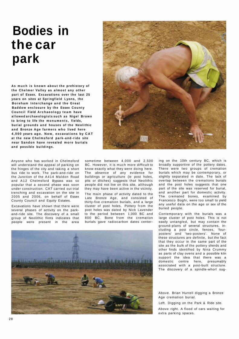
Anyone who has worked in Chelmsford will understand the appeal of parking on the fringes of the city and taking a short bus ride to work. The park-and-ride on the Junction of the A 4 1 4 Ma ldon Road and A 1 2 Chelmsford Bypass was so popular that a second phase was soon under construct ion. CAT carried out trial t renching and excavation on the site in 2005 and 2006 , on behalf of Essex County Council and Equity Estates.
Excavations have shown that there were several phases of activity on the park-and-ride site. The discovery of a small group of Neolithic flints indicates that people were present in the area
somet ime between 4 ,000 and 2 ,500 BC. However, it is much more diff icult to know exactly what they were doing here. The absence of any evidence for buildings or agriculture (ie post holes, pits or ditches) suggests tha t Neolithic people did not live on this site, a l though they may have been active in the vicinity.
The main phase of activity dated to the Late Bronze Age, and consisted of thirty-five cremat ion burials, and a large cluster of post holes. Pottery f rom the post holes was dated by Nick Lavender to the period between 1,000 BC and 800 BC. Bone f rom the cremat ion burials gave radiocarbon dates center-
ing on the 10th century BC, which is broadly supportive of the pottery dates. There were two groups of cremation burials which may be contemporary, or slightly separated in date. The lack of overlap between the cremations burials and the post holes suggests that one part of the site was reserved for burial, and another part for domestic activity. The cremated bones, examined by Francesco Boghi, were too small to yield any useful data on the age or sex of the buried people.
Contemporary with the burials was a large cluster of post holes. This is not easily untangled, but may contain the ground-plans of several structures, inc luding a post circle, fences, 'four-posters' and ' two-posters'. None of these structures are definite, but the fact that they occur in the same part of the site as the bulk of the pottery sherds and other finds identif ied by Nina Crummy as parts of clay ovens and a possible kiln support the idea tha t there was a domestic centre here, presumably associated with a post-built structure. The discovery of a spindle-whorl sug-
Above. Brian Hurrell d igging a Bronze Age cremat ion burial.
Left. Digging on the Park & Ride site.
Above right. A f lood of cars wait ing for extra parking spaces.
28

gests that the local economy included weaving. There were two buried vessels in among the post-hole cluster. As these were empty, it is diff icult to argue that they were burials. Conventionally, archaeologists interpret these as 'placed deposits' whose ritual signif icance may be lost on the modern observer.
In a later phase (still in the Late Bronze Age or possibly the Early Iron Age) field ditches were laid out across the site. As these cut through the post holes and cremations, they must herald a com-plete change in land use. It would be normal to interpret this as a change to pastoral fa rming, with the land being allowed to revert to grass, and a system of hedges and ditches used to control stock. The layout of the ditches, wi th one being a possible stock funnel , does not contradict this interpretat ion.
The final phase of activity was in the Middle Iron Age, when a number of pits were cut through the field ditches. Qui te what they mean is diff icult to say, but pits would usually suggest an element of domestic occupat ion.
It is easy to see the bui lding of the car park as a rather brutal end to the history of the site. But it can be argued that this latest change is in keeping with the earlier changes of land-use whereby populations adapted the land to suit their own particular needs. So who knows, perhaps one day car parks will be of great interest to archaeologists!
Howard Brooks and Ben Holloway
The above il lustration shows the radiocarbon dates for five of the cremat ion burials f rom the Chelmsford park-and-r ide site. There is a little scientific jargon here, which needs to be understood so that we can read off ' rea l ' dates. The left side of the il lustration shows each sample with its reference number, and a date in years BP fol lowed by a ' ± ' notat ion. BP stands for Before Present, which by international agreement is the year AD 1950. Let us take the first result as an example. To convert this 'Before Present' date to a 'Before Christ' date, subtract 1950 f rom 2910 , the answer of course being 960 (BC). In fact this date is only the centre point of a range which is given as ± 5 0 , or 50 years on either side of 9 6 0 BC (ie 1010 BC - 910 BC). (To compl icate matters though , we need to bear in mind that for each of the ' rea l ' dates, there is a small possibility it actually lies outside its date range.) The f inal bit of scientific jargon is ' C a l B C . This refers to the fact tha t ' raw' radiocarbon dates are too ' young ' , and have to be cal ibrated against tree-ring dates to give a reading in ' rea l ' or calendar years BC. The scale along the bot tom of the il lustration shows calibrated dates (ie dates in ' rea l ' years BC).
Thus, the centre points of all five dates are (reading down the co lumn) 960 BC, 900 BC, 875 BC, 695 BC, 840 BC (each one with a small error marg in of 35 to 50 years). These dates all coincide with the Late Bronze Age. The dat ing work was carried out by the Scottish Universities Environmental Research Centre in East Kilbride.

The dykes of Camulodunon: anti-chariot defences or boundaries of a major trading centre?
David G r o c o t t argues t h a t t h e dykes o f
Colchester - f o r so long seen as t h e a n c i e n t
defences of the t o w n - m a y have been
n o t h i n g of the sort .
The tradit ional interpretation of the Dykes of Iron Age Colchester has been tha t they were defences drawn up through later prehistory to defend an area inhabited by a pastoral fa rming elite of militaristic local chieftains. Men daubed with woad would stand behind these barriers and stare out across the land, await ing attack. This interpre-tat ion has always had a heavy emphasis on the defensive capabil i ty of the dykes and has not looked at what I believe is a more likely alternative - that the dykes were far more important than mere defence. I believe the dykes were there primarily to mark an area of special significance, an area of special import -ance far greater than previously thought - an area of special signif icance that has parallels in the Far East and Scandinavia.
The dykes form a network tha t mostly help to join the Roman River with the Colne and, with these river valleys, create a sealed-off area. But apart f rom that , why do we think the dykes are primarily defensive?
Well the Iron Age name of Colchester, Camulodunum - the fortress of the War God - rather sets the tone. But apart f rom that the answer is that we just seem to think the dykes are defensive because of their scale. We do have Roman historians, like Strabo, who talk about the British and describe their large settlements as being 'in the wood ' using natural barriers, marshes, rivers etc in conjunct ion with man-made fort i f i cations. Tha t certainly fits with the model of Colchester and the artificial boundaries working in conjunct ion with the rivers Roman and Colne. Romans, including Julius Caesar, also tell us that the Britons were incredibly war-l ike and ferocious. Both Strabo and Caesar
provide great detai l about the use of chariots in British warfare. This is of course seen by many archaeologists as all the proof needed to say that the Britons, incredibly war-l ike in their general demeanour , had built the dykes to prevent the of t -quoted ' f lowing ' chariot warfare which would be broken against the tank-trap-l ike structures that are the dykes. Alas, I do not believe this is an a rgument we should trust.
It is famously diff icult to identify warfare in archaeology. Two thousand years on , a ferocious batt le would amoun t to little within the archaeological record, and chariot format ions would count for even less. Isolated examples such as piles of sling stones at south coast hill forts and ballista bolts f rom Roman war engines are our only gl impse into what must undoubtedly be an under-represented feature of Britain's ancient past.
But tha t aside you can ' t get away f rom the fact tha t the point of archaeology is to base your understanding on what you can prove and in Colchester there is very little to suggest warfare. There is a revetment at the f ront of one of the dykes in Lexden, but tha t is remarkable for being a seeming one off. It is also impor tant to remember the polit ical mot ivat ion for Caesar to exaggerate the warl ike nature of the people he met in Britain to boost his own prowess in his quest to become emperor.
Whereas evidence of warfare and defence is conspicuous by its absence at Camu lodunum, evidence for t rade is disproport ionately abundant . Coin moulds at Sheepen, cont inental pottery and metalwork, amphora and jewellery are all to be found by the imported bucket load. Colchester was, everyone agrees, a major focus of t rade.
Iron Age warriors in act ion at Camu lodunon as they race out of one of the entrances in the dykes. Reconstruction by Peter Froste.
A similar story is to be found at other so-called oppida like Colchester, where large dykes have been seen for decades as evidence of warfare and defence. Here there is no sign of warfare but there are coin moulds and monetary concentrat ions. From a strictly archaeo-logical perspective then, the evidence is clear - Colchester was all t rade and not defence.
So if the dykes weren' t for defence what might they have been used for? I believe there are two examples f rom history that may show us wha t Iron Age Colchester may have been like and why it had such huge dykes constructed around it.
Firstly are the Viking empor ia which were to be found throughout the first mi l lennium in the Baltic and North Sea. These centres of t rade were surrounded by 'defences' , but the defences, the edges of the sett lements, were not solely barriers against the outside but marked the limits tha t foreigners could move. The famous case for this is Hedeby on the Danish/German border where travellers f rom as far as Moorish Spain came to t rade but could not leave the walls of the sett lement. Here the walls of the sett lement may have originally had a defensive purpose but they became synonymous and symbolic of the limits of special activity tha t could take place within the sett lement.
Closer to Colchester the Romans themselves were very specific in what could be done inside and outside city walls. Walls determined activity - like
30

Al though the walls of Dej ima may look defensive, they clearly were not as the island was never home to more than 100 Dutch merchants, and these walls would have proved completely ineffective if the Japanese ever decided to seriously test the island. The defences were built by the Japanese to keep the island separate and was intended to keep foreigners distinct and show in physical fo rm the limits of t rading. Could this be a parallel to the dykes of Colchester?
burial which was only al lowed outside the city walls. Is it possible that Colchester's status as a t rading centre was marked by the dykes which surrounded it? Could it be tha t inside the initially defensive dykes of the settlement, certain t rading activity grew and became enshrined in increasingly elaborate and less defensive earthworks?
Another example of a t rading centre that is physically separated can be found thousands of miles away f rom Colchester in 17th-century Japan. During the Edo period, f rom 1641-1853, the powerful Shoguns sought to l imit interaction with the outside world and to control t rade. In order to keep some contact while at the same t ime adhering to the principles of isolation, an artif icial island was built in Nagasaki Bay. This island, Dej ima, was for two hundred years the only place in Japan where contact with the west would be permitted. It al lowed the Shoguns of Edo to keep an iron grip on the trade with the west. If you look at the Japanese model of Dej ima, the parallels wi th Colchester are striking. Japan sought isolation or at least control over foreign contact fol lowing instability caused by contact with an al ien and material ly richer culture.
In Britain the Roman conquest of Gaul and the aborted invasions by Caesar had destabilised the southeast and left the British chieftains feel ing insecure -albeit entranced by the material weal th promised by Rome.
In Japan a ruling caste hoped to control trade to reap the benefits of strictly monitored trade. In Colchester the Catuvellaunian tr ibe under Cunobel inus hod established a major sett lement at Colchester specifically to get closer to the trading opened up by the Roman conquest of Gaul . Always remember that for Cunobelinus t rading was the priority in seeking out Colchester - not seeking a good defensive posit ion. And of course in Japan the culture was militaristic but the island of Dej ima was not fortif ied for defence - its walls were built to physically separate the act of t rading with outsiders. In short - as at Dej ima - just because the dykes of Colchester look defensive, it does not necessarily fol low that they were primarily used for defence.
This idea - that Colchester's dykes were built to segregate foreigners and the act of t rading - is not so preposterous. The Greek historian talks about the island of Ictis which later historians and archaeologists have been identif ied as the naturally-excluded St Michael 's Mount in Cornwall . Here on this natural island, Diodorus says, t rade took place between the Britons - rich in t in - and the materially richer foreigners. Ictis is just a naturally occurring Dej ima. Further along the British south coast, the
site of Hengistbury Head near Bourne-mouth was an Iron Age mercanti le centre tha t was posit ioned on a peninsula with its connect ion to the land cut by a di tch and bank. These sites and others like t hem start to suggest a tradi t ion of Iron Age t rading centres physically cut off and separated f rom the surrounding countryside into which foreigners could come and trade. This caut ion need not have been a result of xenophobia (a l though that may have played a part), but was probably the logical extension of centralised and highly control led trade begun in Britain in the Bronze Age.
This is of course a largely academic point. Camu lodunum fell to the Romans in AD 43 , was sacked by Boudica in AD 60 , and began its slow decline f rom powerhouse of Britain to average-size, provincial town. But I feel it is important for us to th ink about the dykes of Iron Age Colchester as not just militaristic chariot traps. For me such a simplistic explanat ion is naive and misses the point. I don ' t th ink it does Colchester or the dykes justice.
David Grocott studied archaeology at Durham University and Popular Culture with the Open University and is currently studying for an MBA.
Other views Similar arguments like this have been made before, ie that the dykes were really land boundaries or they were barriers to control livestock. The trouble with these ideas is that they offer no explanat ion as to why all the dykes on the west side of Camu lodunum faced westwards and the dyke on the east side (Berechurch Dyke) faced eastwards. If the dykes really did have no defensive purpose, then it would not have mattered which way they faced. Moreover, these theories do not convincingly explain why there was a succession of dykes on the west side of Camu lodunum each of which was significantly further west than the last one. A defensive purpose for the dykes is overwhelmingly the most obvious and most likely reason for their existence. However, this is not to say that the other explanations cannot hold good as well . Everybody can still be right and honour can be satisfied all round.
PC
31

The Friends of Colchester Archaeological Trust
Jane Meech, new chairman of the Friends, tries her hand at digging...
My name is Jane Meech, I am the new chai rman of the Friends of CAT, and I have a guilty secret (and just in case this sounds like an introduct ion to Archaeologists Anonymous, don ' t worry, I'll explain later).
The Friends of CAT exists to provide a bridge between the professional archaeologists at the Trust, and members of the public who have an interest in archaeology generally, and especially in what is happening in Colchester, a town that has a seemingly unending supply of surprises whenever a spade is put into the ground. The Friends meet every year in January to hear about the various contracts the Trust has been working on. At the meeting on 20th January 2007 , over 100 Friends enjoyed illustrated talks about the excavations and 'watching briefs' undertaken all over Essex dur ing 2006 , including Marks Tey, Basildon, Great Notley, the Chelmsford park and ride at Sandon, the Crouched Friars site in Colchester, and of course the latest up-date on the Roman circus site. A n d , incidentally, we all enjoyed a splendid tea and cakes session afterwards.
In July and August 2006 , Philip Crummy led two conducted walks around the Roman walls. Both walks were booked to capacity, and Philip shared with us some of his comprehensive knowledge about the building and development of the walls. On a chill day more than 40 Friends gathered at the Napier Road/ Flagstaff Road junct ion, where Philip reminded us of the overall Circus layout, orientation and dimensions, and then led us to where the excavation had revealed one end of the central barrier, where there would have been a turning post (where the chariots would have swung around 360 degrees). While we were there Philip ment ioned that Taylor Woodrow, the developers, had al lowed a trench to be dug in f ront of the Sergeants' Mess. Philip believed this was where the starting gates would have been, and while it was a wonderful chance to establish this, t ime and funds were scarce, and Friends were invited to volunteer to help on the d ig. (I should ment ion at this point that it is not normally possible for volunteers to work on Trust excavations because these are
nearly always related to commercia l developments. However this was an exceptional case because the work was being carried on a research basis.)
Now for my guilty secret - I am a T ime Team fan , and have been since the series started. Before that, in c o m m o n with many other people I would guess, my knowledge of archaeology and its methods was almost ni l , and my interest in same was even less. There are some archaeologists, professional and amateur (but not the Trust I might add) , who have reservations about T ime T e a m , and regard it as 'archaeology l ite'. However, I would argue that anything that arouses and engages the interest of a large swathe of the populat ion, that shows the fascinat ing history that lies beneath our feet, that demystifies and proves that archaeology can be for everyone, can only be A Good Th ing .
So, having been an armchai r archaeologist for all these years, when Philip asked for volunteers, it was my chance to be in there for real! I f ired off an emai l to Philip offering to help, and three weeks later got a phone call f rom Laurie Driver, a Trust archaeologist who was to supervise the dig, tel l ing me that i t was to begin on the 19th February. When Mick, my husband, and I first went four days later, the mechanical diggers had been at work, and in f ront of the Sergeants' Mess was a huge square(ish) hole. My dreams of dainti ly wielding a trowel were immediately destroyed - I soon learnt tha t these early stages are about brute force and muscle power. Now, correct me if I'm wrong, but I cannot recall ever having seen a wheelbarrow on T ime T e a m , and certainly not one full of wet earth. After that first day, which was also cold and very wet, I considered giving up my gym membership, since the digging and the loaded wheelbarrow pushing appeared to be exercising every muscle in my body, including some I was not aware I possessed. Also, at this t ime, I could not make head or tail of what was supposed to be there, it just seemed a jumble of lumps of stone. Over the next three weeks, however, the outl ines of the starting gates began to appear, it gradually started to make sense to me,
Jane and Mick Meech excavating on the site of the circus.
and I even had a f ind - a Roman nail! Laurie, and Emma Spurgeon, another Trust archaeologist and the Trust il lustrator, were models of patience and frequently stopped what they were doing to explain things to me, not only about the site but also to show me the correct techniques. After that first day the weather was a bit kinder to us, but my admirat ion is unbounded for the professionals who have to carry on whatever the elements throw at them. I feel privileged to have had the opportuni ty to be on this d ig, and to experience the thrill of seeing the past appear beneath my trowel. Will I still watch T ime Team? Yes, but with a more critical eye in future, and a far deeper understanding of the hard work and technical knowledge tha t a dig entails.
Not everyone can experience an actual d ig, and maybe I will never do another one, but belonging to the Friends does mean that, via The Colchester Archaeologist, we can keep up to date with the Trust's work. By attending the annual lecture in January we also get a chance to hear f irst-hand f rom the project leaders, and have the opportuni ty to qsk questions and chat to t hem at the tea and cakes session afterwards.
M a n y thanks
Af te r many years of hard work, two key members of the Friends have decided it 's t ime to take a back seat. Af ter a m a m m o t h 25 years (bar just two) , Nina Crummy has handed over the task of organising the tr ips to Jane Meech and founder member Mike Corbishley, and Gabriel le Chadwick has stood down as chairperson af ter 15 years in the job. Both roles are very t ime-consuming , and the work of N ina and Gabrielle are m u c h appreciated by all concerned. However, both will remain active in the Friends. Nina is to cont inue mainta in ing the membership database and Gabriel le plans to help out in more general ways.
32

Colchester Roman circus poster. 841 x 595 mm (A l ) . £5.00 each.
Available by collection from the Colchester Archaeological Trust, 12 Lexden Road, Colchester, C03 3NF during office hours, Monday to Friday,
or by post (but please add £2.50 for post and packing).
I S S N 0152-0166
Colchester Archaeological Trust