ROCKY MOUNTAIN FEN RESEARCH PROJECT SCOPE OF WORK · Rocky Mountain Fen Research Project Scope of...
49
Rocky Mountain Fen Research Project Scope of Work ROCKY MOUNTAIN FEN RESEARCH PROJECT SCOPE OF WORK Prepared For: Rocky Mountain Fen Research Study Team City of Aurora Colorado Mountain College Prepared by: Conlin Associates Resource Planners 875 Mtn. View Dr. Leadville, Colorado 80461 (719) 486-2772 Johnson Environmental Consulting, LLC 1518 W. Oak St. Fort Collins, Colorado 80521 (970) 490-1388 March, 2016
Transcript of ROCKY MOUNTAIN FEN RESEARCH PROJECT SCOPE OF WORK · Rocky Mountain Fen Research Project Scope of...
Rocky Mountain Fen Research Project Scope of Work
ROCKY MOUNTAIN FEN RESEARCH PROJECT SCOPE OF WORK
Prepared For:
Rocky Mountain Fen Research Study Team
City of Aurora Colorado Mountain College
Prepared by:
Conlin Associates Resource Planners 875 Mtn. View Dr.
Leadville, Colorado 80461 (719) 486-2772
Johnson Environmental Consulting, LLC 1518 W. Oak St. Fort Collins, Colorado 80521
(970) 490-1388
March, 2016
Rocky Mountain Fen Research Project Scope of Work
i
Table of Contents Bid Sheet 1 Section 1 Project Goals and Objectives 2
1.1 Problem Statement 1.2 Project Goals 1.3 Project Objectives 1.4 Project Deliverables 3
Section 2 Site Description 4
2.1 General Location 2.2 Physical Setting/Historic Context
Map 1: General Location 5
Section 3 Administration 6
3.1 Project Stakeholders 3.2 Administration
Contact Information 7
Section 4 Glossary of Terms 8
4.1 Glossary Section 5 Project Elements 12
5.1 Goal: Drain and Dry Pond 5.1.1 Problem Statement 5.1.2 Objective
Figure 1: Source Water Diversion 12 Sheet 1: Pond Profile 14
5.1.3 Deliverables 15 Task 1: Source water diversion Task 2: Establish Bypass Task 3: Pump remaining water
5.2 Goal: Remove Sediment Layer 16 5.2.1 Problem Statement 5.2.2 Objective 5.2.3 Deliverables
Task 4: Equipment Mobilization Task 5: Remove Sediment Layer Figure 2: Sediment Repository 17
Rocky Mountain Fen Research Project Scope of Work
ii
Table of Contents (contd.) 5.3 Goal Replace sediment Layer 18 5.3.1 Problem Statement 5.3.2 Objective 5.3.3 Deliverables
Task 6: Install Geogrid Task 7: Haul and Place Fill Sheet 2: Basin Modification 19 Figure 3: Material Stockpile 20 5.4 Goal: Construct Inlet Works 21 5.4.1 Problem Statement 5.4.2 Objective 5.4.3 Deliverables Task 8: Cobble Placement Task 9: Geomembrane installation Task 10: Dam and Water Channel Drawing 3: Inlet Spring – Detail 22 Drawing 4: Staging and Stockpile Area 23 5.5 Goal: Construct Outlet Works 24 5.5.1 Problem Statement 5.5.2 Objective 5.5.3 Deliverables Task 11: Remove Existing Culvert Task 12: Construct Infiltration Gallery Drawing 5: Infiltration Gallery 25 Drawing 6: Outlet Works 26 Task 13: Pour Slab 27 Task 14: Form and Pour Outlet Structure 5.6 Goal: Construct Water Tracks 28 5.6.1 Problem Statement 5.6.2 Objective 5.6.3 Deliverables Task 15: Construct Main Water Track Task 16: Construct Capillary Water Tracks Sheet 7: Water Tracks and Peat Placement 29
Rocky Mountain Fen Research Project Scope of Work
iii
Table of Contents (contd.) 5.7 Goal: Harvest Fen Soils and Vegetation 30 5.7.1 Problem Statement 5.7.2 Objective 5.7.3 Deliverables 32 Task 17: Equipment Mobilization
Task 18: Harvest Mixed Peat Task 19: Harvest Peat Blocks 5.8 Goal: Transport Peat to Receiver Site 33 5.8.1 Problem Statement 5.8.2 Objective 5.8.3 Deliverables Task 20: Haul Peat Blocks
Task 21: Haul Mixed Peat 34 Figure 4: Peat Transport Haul Route
5.9 Goal: Placement of Peat Soils in Receiver Site 35 5.9.1 Problem Statement 5.9.2 Objective 5.9.3 Deliverables Task 22: Placement of Direct Contact Blocks Task 23: Placement of Spaced Blocks 36 Task 24: Placement of Mixed Peat 5.10 Demobilization and Cleanup 37 5.10.1 Problem Statement 5.10.2 Objective 5.10.3 Deliverables Task 25: Site Cleanup
Task 26: Demobilization
Rocky Mountain Fen Research Project Scope of Work
iv
Table of Contents (contd.)
Section 6 Construction Services 38
6.1 Temporary Facilities 6.2 Construction Utilities 6.3 Water 6.4 Sanitary Facilities 39 6.5 First Aid 6.6 Construction Surveying 6.7 Cleanup 6.8 Removal of Water 6.9 Revegetation 40 6.10 Haul Roads, Access Roads and Ramps 41 6.11 Temporary Stockpile Areas 6.12 Spoil Material 6.13 Fill and Backfill Material 42 6.14 Borrow Area 6.15 Material Specifications and Installation
Section 7 Timeline 43
7.1 Problem Statement 7.2 Objective 7.3 Tasks and Timeline 44
Table 1: Tasks Figure 6: Timeline

Rocky Mountain Fen Research Project Scope of Work
1
INSERT BID SHEET HERE
Rocky Mountain Fen Research Project Scope of Work
2
Section 1 Project Goals and Objectives
1.1 Problem Statement
Fens are groundwater fed peat wetlands found at high elevations (above 8000 feet) in Colorado, typically exhibiting neutral pH and moderate to high nutrient levels. Unlike more common wetland systems, fens require constant groundwater saturation in order to prevent oxidation and to sustain positive carbon influx and support bicarbonate cycling, or they can rapidly decompose. A consistent and reliable groundwater source is required to maintain a constant level of saturation, regardless of vagaries in climate and precipitation. Because fens result from the incomplete decomposition of plant matter in the cold, harsh climate of the Colorado high country, they can take thousands of years to develop a sufficient depth of peat, and to evolve the unique plant communities that characterize the fen wetland type. Given the long time frame required for peat development, fens are considered to be irreplaceable and un-mitigatable resources. The U.S. Fish and Wildlife Service has established a Resource Category 1 policy of “no loss of existing habitat value” indicating that “because of the irreplaceability of the type of habitat, every reasonable effort should be made to avoid impacting that habitat type.”1
When a project is going to destroy all or part of a fen, as much of the habitat should be extracted as possible. The RMFRP will forward the science and test the effectiveness of ecological salvage, by translocating blocks of organic soil and wetland habitat to a peat mine restoration site.
1.2 Project Goals
The Rocky Mountain Fen Research Project seeks to explore and demonstrate new experimental approaches to salvage, relocation, and restoration of Histosols and wetland specific vegetation. The goal of the study program is to advance scientific knowledge of fen restoration and mitigation practices that can restore or recreate the form and function of a natural fen wetland.
1.3 Project Objectives The objective of the project is to test the hypothesis that salvaging and transplanting intact Histosols (peat) and vegetation into a modified groundwater fed basin can restore and maintain the form and function of a natural fen wetland.
1 Regional Policy on the Protection of Fens, as Amended, USDI Fish & Wildlife Service, January 20, 1999
Rocky Mountain Fen Research Project Scope of Work
3
1.4 Project Deliverables
Organic peat soils will be harvested from a relic fen on the Derry Ranch for transplantation to the site of a previously harvested fen on the Hayden Ranch. The Hayden Ranch fen was harvested in the 1940’s to supplement ranch revenues during the war years. Peat soils were excavated, dried, and packaged for sale as an agricultural soil amendment, and the excavated basins were dammed to create ponds for fishing and stock watering. The result was a conversion of the resource from a slope wetland (i.e. fen), to a depressional (i.e. excavated) wetland type. The groundwater source that originally fed the Hayden Ranch fen remains viable and available for use in restoring the damaged fen wetland. Project tasks are described in detail in Section 5, and will include draining and temporarily drying one of the Hayden ponds to allow for the use of heavy construction equipment to re-contour the basin prior to transplantation of harvested peat and vegetation. Pond sediments will be removed and hauled to an on-site repository and replaced with structural fill from a stockpile on the City of Aurora’s property to provide a competent construction foundation. Inlet and outlet structures will be constructed to replicate the sub-surface groundwater delivery typical of a fen wetland. Water Track channels and capillary distributaries constructed of permeable sand and gravel will be placed between blocks of relatively impermeable peat. These preferential flow paths will help spread sub-surface water more evenly throughout the wetland. Peat from the Histic Epipedon will be harvested from the Derry Ranch using a specialized peat harvester that cuts uniform blocks of intact soil and vegetation. Blocks will be loaded onto modified tilt/conveyor hay trailers that will deliver materials to the Hayden Ranch receiver site. Once on site, the blocks will be re-positioned in adjacent and spaced configurations to allow analysis and contrasting of indicators of success, including propagation rates, soil redox, pH, and spread of rhizomatous vegetation. Mixed peat, excavated and transported by conventional means from the Derry Ranch harvest site, will be used to fill the voids between spaced blocks, and distributed in a control cell to allow analysis and contrast of success of the blocked material versus randomly excavated and distributed peat. Ground water flow will be re-established to the basin, and the site will be monitored to determine whether the form and function of the previously harvested Hayden Ranch fen has been successfully restored.
Rocky Mountain Fen Research Project Scope of Work
4
Section 2.0 Site Description
2.1 General Location
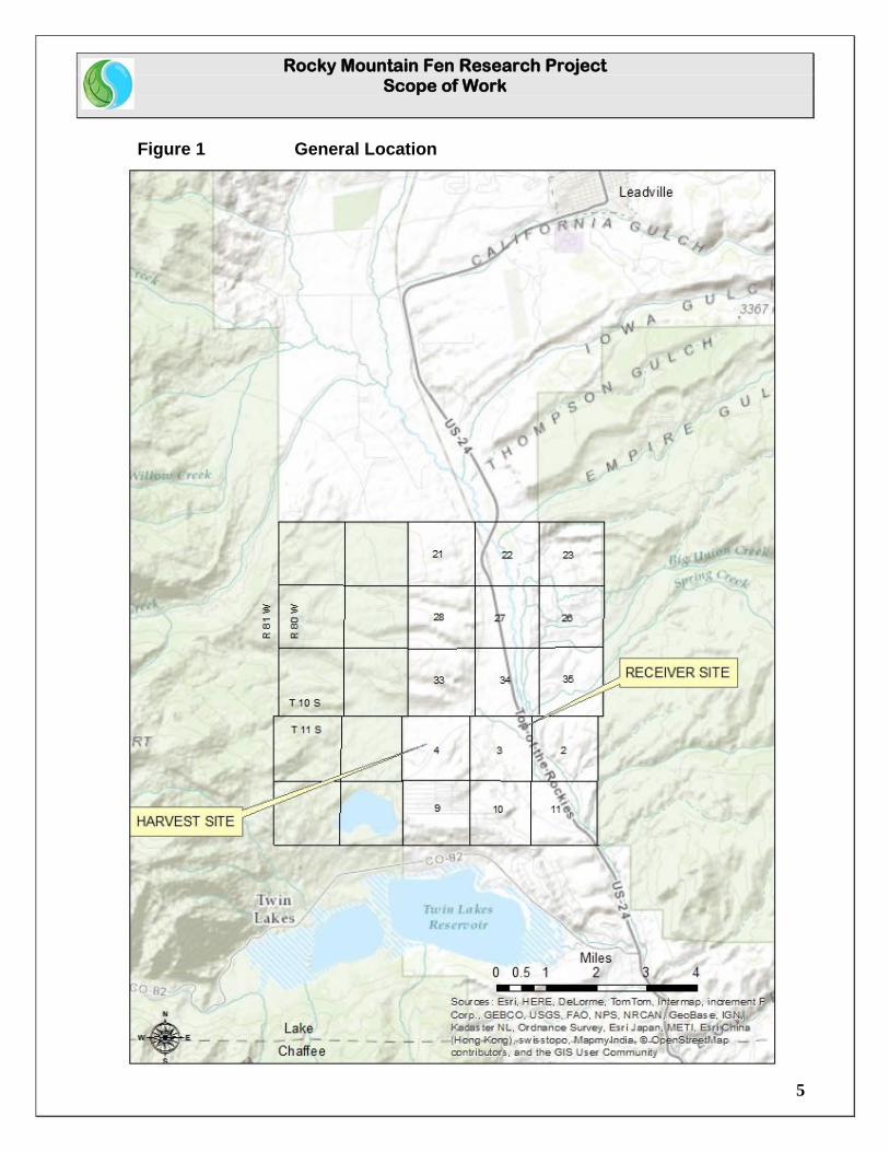
The Rocky Mountain Fen Research Project is located in the Upper Arkansas River Valley, approximately 10 miles south of Leadville, in Lake County, Colorado. (Figure 1: General Location) The primary project components include a harvest site, from which peat soils and vegetation will be extracted, and a fen receiver site into which peat soils and vegetation will be transplanted. The harvest site is located on the Derry Ranch in Section 4, Township 11 South, Range 80 West of the 6th Principal Meridian, in Lake County, Colorado. The Derry Ranch is held in fee simple ownership by the City of Aurora. The fen receiver site is located on the Hayden Ranch Headquarters parcel in the Northeast ¼ of Section 3, Township 11 South, Range 80 West of the 6th Principal Meridian, in Lake County Colorado. The Hayden Ranch Headquarters parcel is held in fee simple ownership by Colorado Mountain College.
2.2 Physical Setting / Historic Context
The Upper Arkansas River Valley is situated in a Graben, or “down-thrown block”, bounded on the east by the Mosquito Range, and on the west by the Sawatch Range. Colorado’s two highest peaks, Mount Elbert (14,440 ft. msl) and Mount Massive (14, 428 ft. msl) are visible in the Sawatch Range to the west of the project area. The Hayden and Derry Ranches are situated on the west side of U.S. Highway 24, the Top of the Rockies National Scenic and Historic Byway, in the valley of the Upper Arkansas River. The Arkansas River flows to the east of the Byway. The Hayden and Derry Ranches were homesteaded in the early 1860’s, and their rich bottom lands provided hay to fuel the literal “horsepower” of the day in the historic Leadville Mining District, and to raise livestock to feed the population of the booming mining camp. The Hayden Ranch Headquarters is a National Historic Landmark District (5LK 1340). A Deed of Conservation Easement on the Ranch Headquarters is held by the Colorado Historical Foundation. The Derry Ranch witnessed major dredge and dry land placer mining around the turn of the century, resulting in significant ground disturbance and deposition of waste rock piles. The Derry Mining Site Camp (5LK 1341) is listed on the National Register of Historic Places.
Rocky Mountain Fen Research Project Scope of Work
5
Figure 1 General Location

Rocky Mountain Fen Research Project Scope of Work
6
Section 3 Administration
3.1 Project Stakeholders
Stakeholders and participants in the Rocky Mountain Fen Research Project include Landowners, the Technical Study Team, professional consultants, and project administrators.
Landowners
Colorado Mountain College – Hayden Ranch Headquarters City of Aurora – Derry Ranch
Study Team
U.S. Environmental Protection Agency U.S. Fish & Wildlife Service U.S. Army Corps of Engineers Aurora Water Pueblo Board of Water Works Colorado Mountain College Frontier Environmental Lake County, Colorado Land Trust of the Upper Arkansas
Consultants
Johnson Environmental Consulting, LLC – Professional Wetland Scientist Conlin Associates Resource Planners – Facilitator
3.2 Administrators
Contract Administration and Compliance will be the responsibility of Colorado Mountain College’s Natural Resource Management Program, Cathy Patti, Administrator. Project Supervision and Analysis will be the responsibility of the Professional Wetland Scientist, Dr. Brad Johnson. Project Facilitation and Coordination will be the responsibility of Conlin Associates: Land and Resource Planners, Michael Conlin, Principal. Landowner representative for the City of Aurora will be Kathy Kitzmann, Senior Water Resources Engineer, Aurora Water.
Rocky Mountain Fen Research Project Scope of Work
7
Contact Information: Cathy Patti Program Administrator Colorado Mountain College, Natural Resource Management Program 901 S. Highway 24 Leadville, Colorado 80461 (719) 486-4232 (970) 376-3324 (Cell) [email protected] Brad Johnson, PhD, P.W.S. Johnson Environmental Consulting, LLC 1518 W. Oak St. Fort Collins, Colorado 80521 (970) 490-1388 (970) 658 7782 (Cell) [email protected] Michael Conlin, Principal Conlin Associates: Land and Resource Planners 875 Mountain View Dr. Leadville, Colorado 80461 (719) 486-2772 (719) 207-0321 (Cell) [email protected] Kathy Kitzmann Senior Water Resources Engineer Aurora Water 15151 E Alameda Pkwy, Ste 3600 Aurora, CO 80012 (303) 739-7533 (720) 427-6854 (Cell) [email protected]
Rocky Mountain Fen Research Project Scope of Work
8
Section 4 Glossary of Terms
4.1 Glossary
ACOE – U.S. Army Corps of Engineers, responsible for wetland permitting. ACOE Nationwide 27 Permit – Army Corps of Engineer’s Permit allowing minimal wetland disturbance for the purpose of Aquatic Habitat Restoration, Establishment, and Enhancement Activities. Adjacent Peat Blocks – Intact blocks of peat material and vegetation, cut by a mechanical peat harvester, re-assembled at the receiver site to be in contact with one another. BLM – The U.S. Department of the Interior, Bureau of Land Management. BLM Pond – Historic fen wetland, excavated for peat soils and dammed to create a fishing pond, located downstream of the Hayden Fen Receiver Pond, and owned by the U.S.D.I Bureau of Land Management. Capillary Track – A channel of cobble underlying the peat soils, designed to increase water conductivity to allow preferential channeling and greater distribution of water throughout the fen basin. CMC – Colorado Mountain College, owner of the Hayden Ranch Headquarters and fen receiver site. Disclaimer of Jurisdiction – Determination by the U.S. Army Corps of Engineers that extraction of peat from the Derry Ranch Harvest site is non-jurisdictional and does not require a Corp’s permit. Declaratory Order – An action by the State of Colorado, Department of Minerals and Geology, exempting the Rocky Mountain Fen Research Project from the requirement of a submitting Mined Land Reclamation Permit to extract fen materials from the Derry Ranch harvest site for research purposes. EPA – U.S. Environmental Protection Agency. EPA Agreement and Covenant Not to Sue - An Agreement is entered into pursuant to the Comprehensive Environmental Response, Compensation, and Liability Act of 1980, as amended (“CERCLA”), 42 U.S.C. § 9601, et seq., and Section 7003 of the Solid Waste Disposal Act, commonly referred to as the Resource Conservation and Recovery Act of 1976, as amended by the Hazardous and Solid Waste Amendments of 1984 (“RCRA”), 42 U.S.C. § 6973, and the authority of the Attorney General of the United States to compromise and settle claims of the United States.
Rocky Mountain Fen Research Project Scope of Work
9
Fen - A type of groundwater-fed wetland formed through the incomplete decomposition of organic matter, resulting in the formation of peat soils, and typically exhibiting neutral pH and moderate to high nutrient levels. Usually found only above 8,000 feet elevation in Colorado. Fen Receiver Pond - Pond located on the Hayden Homestead that resulted from the excavation of peat for sale as a soil amendment, and subsequent damming to create a fishing pond. The pond will be modified for transplantation of peat soils to test the success of restoring the form and function of the damaged fen. Floodplain – Area of land that borders a stream and is subject to inundation under flood stage conditions. Fluvial – Of or pertaining to a river or rivers. FWS – The U.S. Fish and Wildlife Service. Geographic Information System (GIS) – A map based database that allows users to acquire, store, manipulate, analyze and display spatial data. Groundwater – The supply of fresh water found beneath the earth’s surface. Habitat – Place where an animal or plant normally lives, often characterized by a dominant form or physical characteristic (e.g. stream habitat, wetland habitat). Harvest Site – The site on the Derry Ranch from which peat soils will be excavated for transplantation to the fen receiver site on the Hayden Ranch. Harvest boundaries to be determined by the PWS. Histosol – A histosol is a soil consisting primarily of organic materials with an organic layer at least 16 inches thick. Histic Epipedon - An 8- to 16-inch soil layer at or near the surface that is saturated for 30 consecutive days or more during the growing season in most years and contains a minimum of 20 percent organic matter when no clay is present or a minimum of 30 percent organic matter when 60 percent or more clay is present, generally a thin horizon of peat or muck. Hydrology – The science of dealing with the occurrence, distribution, and circulation of water.
Rocky Mountain Fen Research Project Scope of Work
10
Infiltration Gallery - A structure constructed of gravel or cobble to expedite transfer of water to or from a soil aquifer. In this instance, an infiltration gallery is used to collect water from the full width of the downstream fen basin berm for delivery to the outlet structure to prevent pooling. K- Value - The hydraulic conductivity (K), determines how much water can flow through a given soil system within a given time frame. Mixed Peat – Peat soils excavated and transported by conventional means resulting in a random mixing of soils and vegetation. Operable Unit (OU) – Term for a portion of or a separate activity undertaken as part of a Superfund site cleanup. The fen receiver basin is part of OU 11 of the California Gulch Superfund Site. Peat - Peat is an accumulation of partially decayed vegetation or organic matter that is unique to natural areas called peatlands, fens, bogs, or mires. Peat forms where the "annual rate of biomass production is greater than the rate of decomposition", and can take thousands of years to accumulate to sufficient depths to be classified as a fen. Peat Blocks – The term peat block refers to uniform, mechanically cut units of peat soils with intact vegetation, extracted from the Derry Ranch harvest site. Peat Harvesting Attachment – Mechanical attachment that mounts to a track hoe to cut uniform blocks of peat soils with vegetation intact for reassembly at the Fen Receiver Site. Plant Cover – A measure of the percent of ground covered with live vegetation. PWS – The Professional Wetland Scientist. Receiver Site – The pond on the Hayden Ranch that will be modified to receive peat soils for transplantation. Relic Fen - Native fen habitat which has lost a critical supportive component, including groundwater supply, characteristic soil environment, or vegetation, because of land use or other anthropogenic cause. Riparian Zone – Area of land that borders a stream that is located between standing water and uplands. Plant growth in this area is influenced by additional water associated with the stream system.

Rocky Mountain Fen Research Project Scope of Work
11
Spaced Peat Blocks – Mechanically cut blocks of peat distributed in the receiver basin with 1 foot perimeter spacing. Spaces between the blocks will be filled with mixed peat to determine the ability of the blocks to propagate fen species rhizomatously between the blocks, increasing the ratio of fen created to fen extracted. Terrestrial – Pertaining to land, as distinct from air and water. Water Track –A pathway of high conductivity flow formed by placing permeable fill between peat material.
Rocky Mountain Fen Research Project Scope of Work
12
Section 5 Project Elements
Section 5.1 Goal: Drain and Dry the Fen Pond
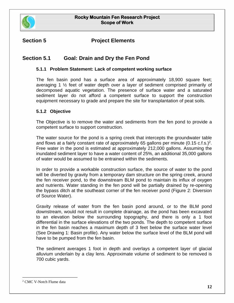
5.1.1 Problem Statement: Lack of competent working surface The fen basin pond has a surface area of approximately 18,900 square feet; averaging 1 ½ feet of water depth over a layer of sediment comprised primarily of decomposed aquatic vegetation. The presence of surface water and a saturated sediment layer do not afford a competent surface to support the construction equipment necessary to grade and prepare the site for transplantation of peat soils. 5.1.2 Objective The Objective is to remove the water and sediments from the fen pond to provide a competent surface to support construction. The water source for the pond is a spring creek that intercepts the groundwater table and flows at a fairly constant rate of approximately 65 gallons per minute (0.15 c.f.s.)2. Free water in the pond is estimated at approximately 212,000 gallons. Assuming the inundated sediment layer to have a water content of 25%, an additional 35,000 gallons of water would be assumed to be entrained within the sediments. In order to provide a workable construction surface, the source of water to the pond will be diverted by gravity from a temporary dam structure on the spring creek, around the fen receiver pond, to the downstream BLM pond to maintain its influx of oxygen and nutrients. Water standing in the fen pond will be partially drained by re-opening the bypass ditch at the southeast corner of the fen receiver pond (Figure 2: Diversion of Source Water). Gravity release of water from the fen basin pond around, or to the BLM pond downstream, would not result in complete drainage, as the pond has been excavated to an elevation below the surrounding topography, and there is only a 1 foot differential in the surface elevations of the two ponds. The depth to competent surface in the fen basin reaches a maximum depth of 3 feet below the surface water level (See Drawing 1: Basin profile). Any water below the surface level of the BLM pond will have to be pumped from the fen basin.
The sediment averages 1 foot in depth and overlays a competent layer of glacial alluvium underlain by a clay lens. Approximate volume of sediment to be removed is 700 cubic yards.
2 CMC V-Notch Flume data
Rocky Mountain Fen Research Project Scope of Work
13
Figure 2: Diversion of source water
Rocky Mountain Fen Research Project Scope of Work
14
Sheet 1 – Replace with 11 x 17 folded map
Sheet 1
Rocky Mountain Fen Research Project Scope of Work
15
5.1.3 Deliverables Task 1 Task 1 will be to construct a diversion structure across the spring creek approximately 160 feet north of the inlet of the fen pond (see Figure 2: Diversion of Source Water), and extend a pipeline running from a flange in the face of the structure, along an alignment between Highway 24 and the fen receiver basin, bypassing the water around the receiver site to the BLM pond. Task 1 will be performed by Colorado Mountain College approximately one month prior to start of construction to allow sediments in the bottom of the pond to dry. Task 2 Task 2 will be to excavate the entrance of the existing ditch bypassing the BLM pond located at the southeast corner of the pond (See: Figure 2: Diversion of Source Water) to allow gravity discharge of the surface water to the extent possible within the grade restrictions of the ditch. Task 2 will be performed by Colorado Mountain College approximately one month prior to the start of construction to allow sediments in the bottom of the pond to dry. Task 3 Task 3 will be to pump the remaining water from the fen basin into the discharge ditch at the southeast corner of the existing pond. A sediment trap will be installed in the alignment of the ditch to trap water borne sediments that will be carried in the pumped water. Task 3 will be performed by Colorado Mountain College approximately one month prior to the start of construction, and periodically thereafter as necessary to allow sediments in the bottom of the pond to dry.
Rocky Mountain Fen Research Project Scope of Work
16
Section 5.2 Goal: Remove sediment layer 5.2.1 Problem Statement
The existing layer of sediment in the fen basin will not provide a workable surface for construction equipment, or allow for establishing sustainable grades in the bottom of the basin. The sediment layer must be removed to allow machine grading and preparation of the basin for transplantation of peat soils and vegetation. 5.2.2 Objective
The objective is to remove approximately 1 foot (~ 700 cubic yards) of sediment from the bottom of the fen receiver pond. Sediments will be excavated and hauled to an on-site repository, approximately 0.4 miles from the fen receiver site (Figure 3: Sediment Repository). Sediment will be spread to an approximate depth of 1 foot to allow for on-site capping of a contaminated irrigated meadow. Repository boundaries will be determined by the College, but will be within the Hayden Homestead property. CMC will be responsible for final grading of the sediments as well as revegetation with native species. 5.2.3 Deliverables
Task 4 Equipment Mobilization and site preparation. Task 5 Remove and deliver approximately 700 cubic yards of sediment to the repository site. Once the material has had a chance to dry, contractor will be responsible for rough grading the repository materials to an approximate depth of 1 foot. Colorado Mountain College will be responsible for final grading the repository material to their specifications and revegetating the soil surface as part of the educational opportunity afforded to students in the Natural Resource Management Program.

Rocky Mountain Fen Research Project Scope of Work
17
Figure 3 Sediment Repository
Rocky Mountain Fen Research Project Scope of Work
18
Section 5.3 Goal: Replace Sediment with Clean Fill
5.3.1 Problem Statement
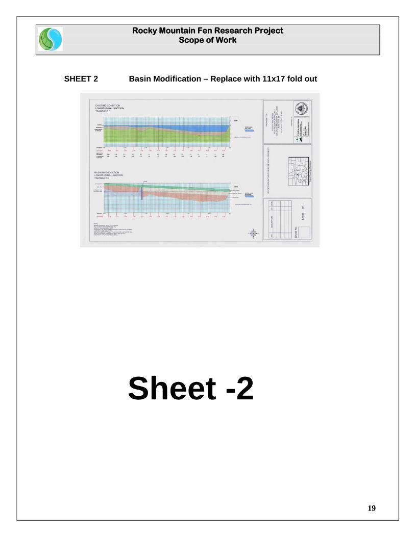
Following removal of the sediment layer, the foundation of the basin will be below grade, and will require the addition of fill material to establish the sub-grade elevation for the installation of project features and transplantation of peat soils. 5.3.2 Objective
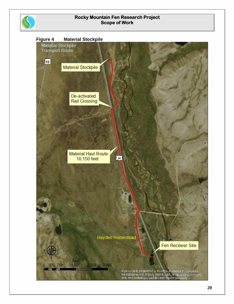
Once the sediment has been removed, native soils will be placed and wheel compacted within the basin to the grade established by the project manager, to provide the sub-base to support the elements of the constructed fen. The structural fill will average 1 ½ feet in depth over the competent surface of the basin (See Drawing 2: Basin Modification), and is estimated at approximately 1,100 cubic yards. The City of Aurora will provide screened ¾ inch to 6 inch structural fill material, stockpiled within 2 miles of the fen receiver site (Figure 4: Material Stockpile). 5.3.3 Deliverables Task 6 Install a layer of geo-grid (Hanes Terragrid or equivalent) over the competent surface to add stability to the soil lifts that will bring the sub-base up to grade. Approximate surface area is 18,000 square feet. Task 7 Load, haul, place, and wheel compact approximately 1,100 cubic yards of ¾ inch to 6 inch structural fill to grade within the fen basin. Haul distance approximately 2 miles each way (Figure 4: Material Stockpile).
Rocky Mountain Fen Research Project Scope of Work
19
SHEET 2 Basin Modification – Replace with 11x17 fold out
Sheet -2
Rocky Mountain Fen Research Project Scope of Work
20
Figure 4 Material Stockpile
Rocky Mountain Fen Research Project Scope of Work
21
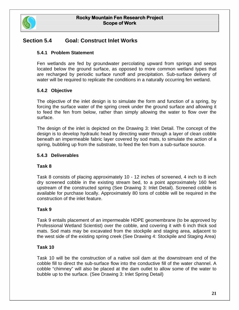
Section 5.4 Goal: Construct Inlet Works
5.4.1 Problem Statement Fen wetlands are fed by groundwater percolating upward from springs and seeps located below the ground surface, as opposed to more common wetland types that are recharged by periodic surface runoff and precipitation. Sub-surface delivery of water will be required to replicate the conditions in a naturally occurring fen wetland.
5.4.2 Objective The objective of the inlet design is to simulate the form and function of a spring, by forcing the surface water of the spring creek under the ground surface and allowing it to feed the fen from below, rather than simply allowing the water to flow over the surface. The design of the inlet is depicted on the Drawing 3: Inlet Detail. The concept of the design is to develop hydraulic head by directing water through a layer of clean cobble beneath an impermeable fabric layer covered by sod mats, to simulate the action of a spring, bubbling up from the substrate, to feed the fen from a sub-surface source. 5.4.3 Deliverables
Task 8 Task 8 consists of placing approximately 10 - 12 inches of screened, 4 inch to 8 inch dry screened cobble in the existing stream bed, to a point approximately 160 feet upstream of the constructed spring (See Drawing 3: Inlet Detail). Screened cobble is available for purchase locally. Approximately 80 tons of cobble will be required in the construction of the inlet feature. Task 9 Task 9 entails placement of an impermeable HDPE geomembrane (to be approved by Professional Wetland Scientist) over the cobble, and covering it with 6 inch thick sod mats. Sod mats may be excavated from the stockpile and staging area, adjacent to the west side of the existing spring creek (See Drawing 4: Stockpile and Staging Area) Task 10 Task 10 will be the construction of a native soil dam at the downstream end of the cobble fill to direct the sub-surface flow into the conductive fill of the water channel. A cobble “chimney” will also be placed at the dam outlet to allow some of the water to bubble up to the surface. (See Drawing 3: Inlet Spring Detail)
Rocky Mountain Fen Research Project Scope of Work
22
SHEET 3 Inlet Detail – Replace with 11x17 fold out
Sheet -3
Rocky Mountain Fen Research Project Scope of Work
23
SHEET 4 Stockpile and Staging Area – Replace with 11x17 fold out
Sheet-4
Section 5.5 Goal: Construct Outlet Works
Rocky Mountain Fen Research Project Scope of Work
24
5.5.1 Problem Statement
If water is allowed to pool and flow over the surface of the fen, the sub-surface dynamics of groundwater recharge, and the specialized vegetation adapted to the nutrient loading and constant saturation typical of a naturally occurring fen could be lost, allowing the fen to revert to a more common form of surface recharged wetland. An outlet placed at the surface elevation of the fen basin would encourage pooling of the water on the surface prior to discharge, and would eventually establish a preferred route for the water to flow over the surface to reach the discharge point. 5.5.2 Objective
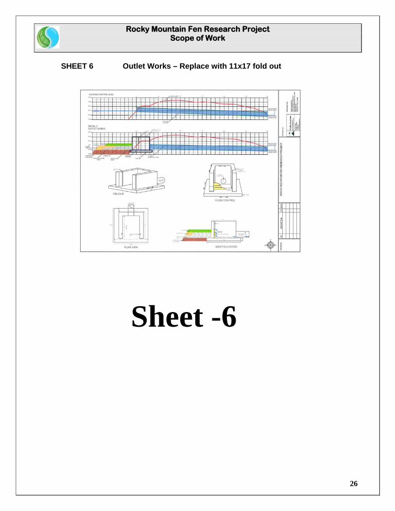
The objective of the outlet works design is to allow water to pass under and through the peat soils as it would in a naturally occurring fen. As designed, the infiltration gallery and outlet works would act to collect water from the full depth of the peat mat, channeling and discharging it to an outlet elevation at the base of the wetland rather than on the surface. The infiltration gallery (Drawing 5: Infiltration Gallery) would serve to collect water along the full length of the constraining down stream dike of the fen basin, while providing a preferred water channel to more evenly drain the basin from the full depth of the body of the peat mat and deliver collected water to the outlet structure. The outlet structure (Drawing 6: Outlet Works) would incorporate a slatted interface with the infiltration gallery and peat mats, that can be adjusted to control elevations and outflow volumes passing through the interface to the collection box to allow water flowing under and through the peat mats to discharge without being forced to the surface. The discharge pipe to the BLM pond would be elevated slightly above the base of the collection box to allow trapping of sediment and debris and to allow periodic cleanout if necessary, and would discharge at water level into the BLM pond. 5.5.3 Deliverables
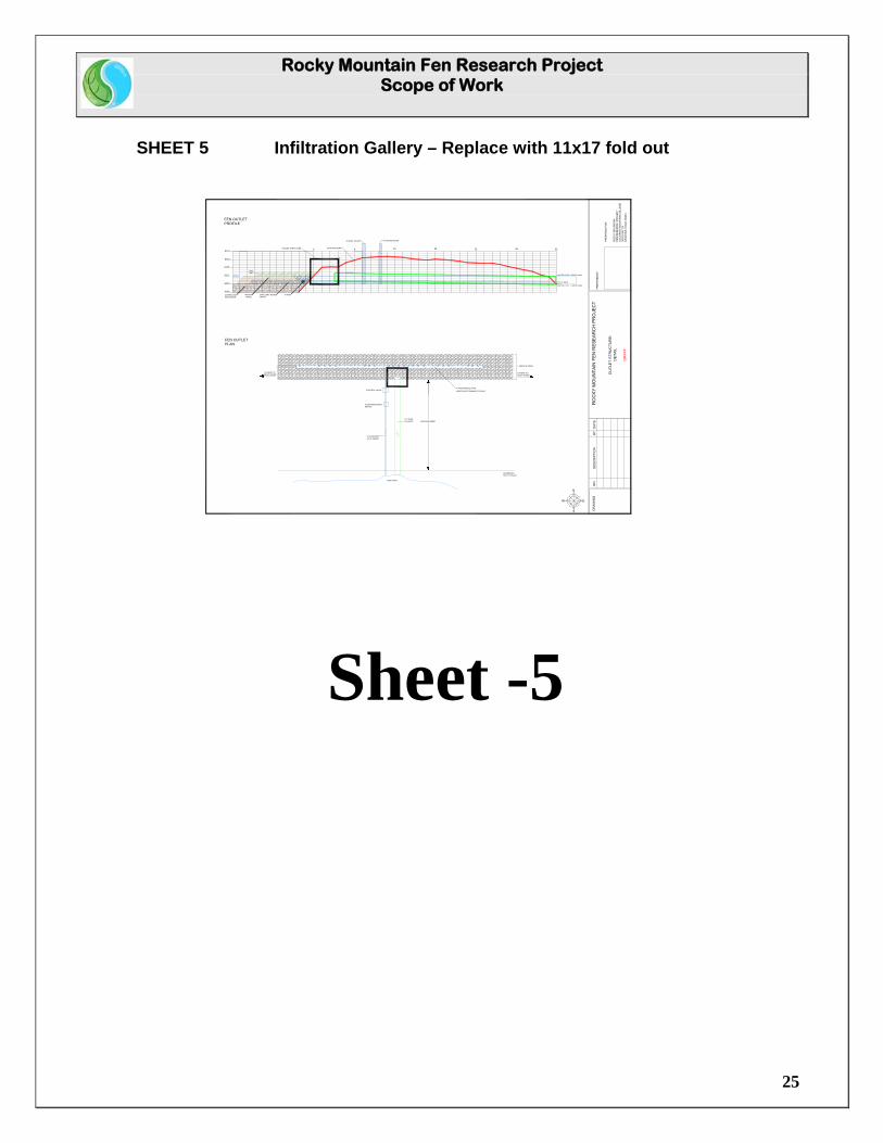
Task 11 Remove the existing culvert and compact backfill to existing berm contours. Task 12 Place approximately 30 tons of 4” to 8” screened cobble in a 5 feet wide infiltration gallery along the 120 foot long face of the dam to a depth of 12 inches above the compacted sub-base (See Sheet 5: Infiltration Gallery).
Rocky Mountain Fen Research Project Scope of Work
25
SHEET 5 Infiltration Gallery – Replace with 11x17 fold out
0 5 10 15 20 25 30
9171
9170
9169
9172
9173
9174
WATER LEVEL: UPPER POND
WATER LEVEL: LOWER POND
1'
WATERTRACK
COMPACTEDSUB-GRADE
4" PIPE
CULVERT
EXISTINGWATER LEVEL
OUTLET VALVE FLOW MEASURE
CAPILLARY WATERTRACK
SODMAT
4" PIPE
EXISTING BERM
CULVERT
4" SOLID PIPE
FLOW MEASURINGDEVICE
CONTROL VALVE
BLM POND
1/2 % GRADE
EXISTING BERM
5' FRENCH DRAIN
EXTEND TO WEST SHORE
FEN OUTLETPROFILE
FEN OUTLETPLAN
N
S
EW
EXTEND TOEAST SHORE
4" PERFORATED PIPELENGTH NOT DRAWN TO SCALE
12" HDPE
OU
TLE
T S
TRU
CTU
RE
: D
ETA
IL
DR
AFT
SCHEMATIC:NOT TO SCALE
OUTLET STRUCTURE
Sheet -5
Rocky Mountain Fen Research Project Scope of Work
26
SHEET 6 Outlet Works – Replace with 11x17 fold out
Sheet -6
Rocky Mountain Fen Research Project Scope of Work
27
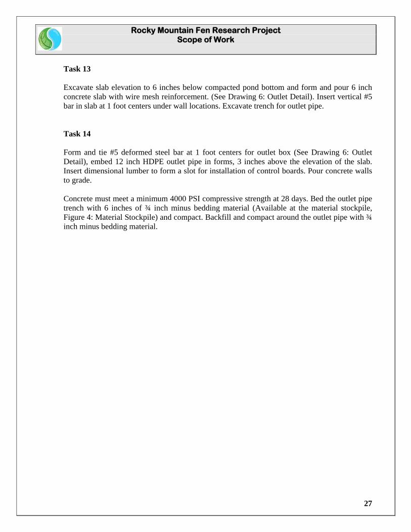
Task 13 Excavate slab elevation to 6 inches below compacted pond bottom and form and pour 6 inch concrete slab with wire mesh reinforcement. (See Drawing 6: Outlet Detail). Insert vertical #5 bar in slab at 1 foot centers under wall locations. Excavate trench for outlet pipe. Task 14 Form and tie #5 deformed steel bar at 1 foot centers for outlet box (See Drawing 6: Outlet Detail), embed 12 inch HDPE outlet pipe in forms, 3 inches above the elevation of the slab. Insert dimensional lumber to form a slot for installation of control boards. Pour concrete walls to grade. Concrete must meet a minimum 4000 PSI compressive strength at 28 days. Bed the outlet pipe trench with 6 inches of ¾ inch minus bedding material (Available at the material stockpile, Figure 4: Material Stockpile) and compact. Backfill and compact around the outlet pipe with ¾ inch minus bedding material.
Rocky Mountain Fen Research Project Scope of Work
28
Section 5.6 Goal: Construct Water Tracks
5.6.1 Problem Statement
Naturally occurring fens typically develop preferred tracks of water flow that present less resistance (K-value) to ground water flow and serve to distribute sufficient water through the body of the fen to maintain its form and function. Without a means of distributing groundwater under and throughout the fen, parts of the wetland can dry up and lose the characteristic form, hydrology, and vegetation of the fen wetland type.
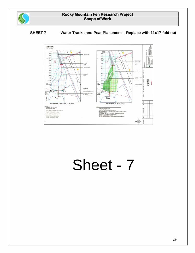
5.6.2 Objective The water tracks are intended to provide a path of reduced resistance for the water to pass under, and through the low conductivity peat soils to distribute water more evenly throughout the basin from below, rather than just applying water over the surface. Flow through the basin is important to ensure that the nutrients in the groundwater reach the fen vegetation, and to keep the basin from ponding. The main water track is designed to be 6 feet in width, and 12 inches in depth, and will consist of bedding sand with a K-Value that allows for conductivity consistent with natural conditions. Bedding sand approved by the Professional Wetland Scientist (PWS) was specified as ACA Product #121, or equivalent. Specifications for the bedding sand are available upon request. Approximately 220 linear feet of water track, requiring an estimated 50 cubic yards (68 tons) of bedding sand, will be constructed (See Drawing 7: Water Track and Peat Placement). Branching off of the main water channel will be capillary water tracks that consist of a band of nominal 2 inch to 4 inch screened and washed cobble, 1.5 feet wide and 8 inches thick, as laid-out in the field by the PWS. Construction of the main and capillary water tracks is anticipated to occur simultaneously with the placement of peat blocks during the transplantation phase, to allow the soil blocks to act as a form to constrain the bedding sand and cobble, and to limit tracking over select materials during peat placement. 5.6.3 Deliverables
Task 15 Place approximately 220 linear feet of bedding sand (ACA Product # 121 or equivalent) at a width of 6 feet and a depth of 12 inches as flagged by the PWS. Task 16 Place approximately 380 linear feet of 2 inch to 4 inch screened and washed cobble at a width of 1.5 feet and a depth of 8 inches along the capillary water track alignments as flagged by the PWS.
Rocky Mountain Fen Research Project Scope of Work
29
SHEET 7 Water Tracks and Peat Placement – Replace with 11x17 fold out
Sheet - 7
Rocky Mountain Fen Research Project Scope of Work
30
Section 5.7 Goal: Harvest Organic Soils and Vegetation
5.7.1 Problem Statement Organic soils (Histosols) form as the result of incomplete decomposition of plant matter in the cold, harsh climate of the Colorado High Country. They can take thousands of years to develop a sufficient depth of peat, and to evolve the unique plant communities that characterize the fen wetland type. Given the extreme length of time required to accumulate an organic layer thick enough to be considered a Histic Epipedon, it is critical that we develop techniques to salvage and translocate those irreplaceable resources in the event that they are going to be unavoidably impacted. 5.7.2 Objective
Given the extreme length of time required to develop fen soils and vegetation, the objective of the project is to test the hypothesis that transplanting intact units of organic soils and vegetation into the groundwater fed Hayden Ranch fen basin can restore the form and function of the damaged Hayden fen wetland, circumventing the time constraints for the soil type and unique vegetation to develop under natural conditions.
The harvest site is located on the Hallenbeck Ranch, approximately 2 miles west of the receiver site on the Hayden Homestead (Figure 1: General Location). Authorization to harvest peat soils has been cleared through a Disclaimer of Jurisdiction from Army Corps of Engineers and a Declaratory Order from the Colorado Mined Land Reclamation Board.
The harvest of peat soils and vegetation will take two forms: the bulk loading of “mixed peat” with standard excavating equipment and dump trucks; and the cutting of peat blocks and intact vegetation using a specialized peat harvester, transported to the receiver site on a specially modified tilt trailers pulled behind a farm tractors.
The specialized peat cutter mounts to a Cat excavator with hydraulics for operation of a thumb. The cutter penetrates the ground, and a hydraulic ram, operated off of the thumb control, closes the box, cutting a uniform block of intact soil and vegetation that is 22 inches wide, 72inches long, and 16inches deep (~11 square feet per block). To unload, the ram is retracted and the block is deposited in the bed of a specially modified trailer.
Rocky Mountain Fen Research Project Scope of Work
31
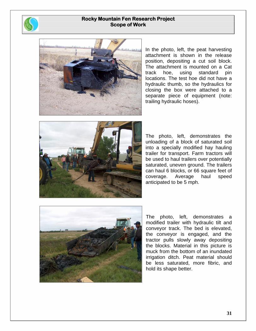
In the photo, left, the peat harvesting attachment is shown in the release position, depositing a cut soil block. The attachment is mounted on a Cat track hoe, using standard pin locations. The test hoe did not have a hydraulic thumb, so the hydraulics for closing the box were attached to a separate piece of equipment (note: trailing hydraulic hoses). The photo, left, demonstrates the unloading of a block of saturated soil into a specially modified hay hauling trailer for transport. Farm tractors will be used to haul trailers over potentially saturated, uneven ground. The trailers can haul 6 blocks, or 66 square feet of coverage. Average haul speed anticipated to be 5 mph. The photo, left, demonstrates a modified trailer with hydraulic tilt and conveyor track. The bed is elevated, the conveyor is engaged, and the tractor pulls slowly away depositing the blocks. Material in this picture is muck from the bottom of an inundated irrigation ditch. Peat material should be less saturated, more fibric, and hold its shape better.
Rocky Mountain Fen Research Project Scope of Work
32
The peat cutting attachment will be provided by the City of Aurora. The track hoe and operator will be provided by the contractor. Four farm tractors and trailers, with operators, will be provided by the City. Colorado Mountain College Natural Resource Management Program will use the harvest area for additional research into wetland restoration. The contractor will not be responsible for revegetation or restoration of the harvest site, but will perform their harvesting in a workman like manner, leaving the site without sharp breaks in terrain, ruts, trash, or obstacles to restoration. 5.7.3 Deliverables
Task 17 Equipment Mobilization and harvest site prep. Task 18 Task 18 will be the harvest of approximately 455 cubic yards of peat soils using standard excavating techniques and transport equipment. “Mixed peat” will be used in an experimental cell within the fen basin to compare propagation success against the use of cut blocks, and to fill the spaces between cut blocks in the “block spacing” experimental cell. (See Drawing 7: Water Tracks and Peat Placement). Mixed peat may be temporarily stockpiled for use at the receiver site in the Staging and Stockpile area illustrated on Sheet 4. Task 19 Task 19 will be to cut and load approximately 11,200 square feet of peat blocks onto the modified trailers (~1,018 blocks), at a typical depth of 16”, for delivery to the adjacent and spaced block experimental cells. At the direction of the PWS, peat blocks overlaying water tracks, the collection gallery along the dam face, capillary water tracks, and to match the taper around the perimeter of the basin will be cut to a typical depth of 6”.
Rocky Mountain Fen Research Project Scope of Work
33
Section 5.8 Goal: Transport Fen Soils and Vegetation
5.7.1 Problem Statement
Peat soils in fens are typically saturated and plastic in nature. Standard excavation using loaders or excavators, followed by loading into dump trucks, and dumping onto the ground results in mixing of the rhizomatous Histic Epipedon and underlying soils. Spreading of the piles to establish the desired grades further mixes the soils, buries vegetation, breaks up the web of interconnecting rhizomes, and compacts the Histic soils. 5.7.2 Objective
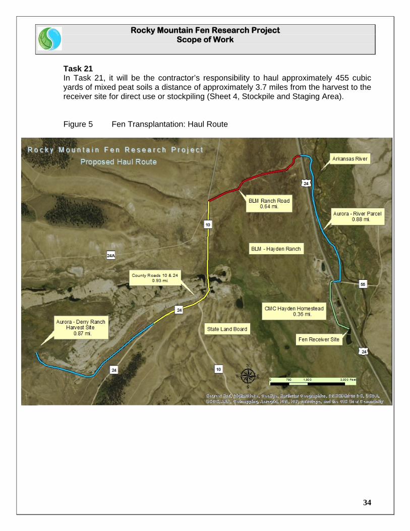
The objective is to harvest and transport intact blocks of organic soil and vegetation from the harvest to the receiver site, and to re-assemble them in a controlled manner that maintains the basic stratigraphy of the Histic Epipedon and its vegetative mat and root structure. Modified bulk hay hauling trailers with hydraulic tilt and conveyor mechanisms will allow uniformly cut blocks of peat material to be unloaded directly onto the ground as the tractor slowly moves forward. Blocks will either be unloaded adjacent to each other to maintain contact, or spaced and “in-filled” with mixed peat to determine whether propagation of vegetation from the spaced blocks will successfully bridge the filled spaces over time. It is anticipated that a Bobcat multi-track loader or similar piece of equipment will be required to move blocks into final position, or to distribute mixed peat around the spaced blocks. Contractor will be responsible for final placement of materials in the basin. Blocked peat materials, excavated and loaded by the contractor, will be transported from the harvest to the receiver site by employees of the City of Aurora, using the City’s farm tractors and modified trailers. Contractor will be responsible for excavating and hauling “mixed peat” from the harvest to the receiver site, using existing County and ranch roads. Haul distance on existing roads is approximately 3.7 miles each way (Figure 5: Fen Transportation: Haul Route). 5.7.3 Deliverables
Task 20 The City’s task will be to deliver and unload approximately 1025 blocks of peat, excavated and loaded by the contractor at the point of harvest, to the receiver site approximately 3.7 miles away across primarily dirt roads (Figure 5: Fen Transportation: Haul Route). Final placement of the blocks will be the responsibility of the Contractor, at the direction of the PWS.
Rocky Mountain Fen Research Project Scope of Work
34
Task 21 In Task 21, it will be the contractor’s responsibility to haul approximately 455 cubic yards of mixed peat soils a distance of approximately 3.7 miles from the harvest to the receiver site for direct use or stockpiling (Sheet 4, Stockpile and Staging Area). Figure 5 Fen Transplantation: Haul Route
Rocky Mountain Fen Research Project Scope of Work
35
Section 5.9 Goal: Placement of Peat Soils
5.9.1 Problem Statement
There is no research contrasting the effectiveness of random dumping of peat soils versus placement of intact blocks into an appropriate hydrologic regime to determine whether the form and function of transplanted peat soils and vegetation can result in restoration or mitigation of a damaged fen wetland. 5.9.2 Objective
The placement of peat soils in the fen basin receiver site will be at the direction of the PWS (See Sheet 7: Water Tracks and Peat Placement). Three test cells will compare the rate of propagation, vegetative spread, and transplantation success of the different treatments in the discrete cells. Cell 1 will place the cut blocks as close together as possible, abutting their edges with adjacent blocks, replicating to the extent possible their spatial relationship in the harvest site. (See Sheet 7: Water Tracks and Peat Placement) A multi-tracked backhoe or equivalent will be required for repositioning the blocks and to ensure a tight fit.
Cell 2 will seek to space the intact blocks approximately 1 foot apart, filling the spaces in between with mixed peat to test the rate of rhizomatous spread between the blocks. (See Sheet 7: Water Tracks and Peat Placement) A multi track hoe may be required to place and grade the mixed peat between the spaced blocks. Cell 3 will dump and spread machine excavated peat soils and vegetation to grade to determine and contrast the random method of distribution with the select placement of intact blocks. Experimentation in South Park has shown a remarkable rate of success of rhizomatous reproduction in placement of mixed fen material into the proper hydrologic regime. Authorization to transplant peat soils into the receiver site is covered under an Army Corps of Engineer’s Nationwide 27 permit allowing minimal wetland disturbance for the purpose of Aquatic Habitat Restoration, Establishment, and Enhancement Activities 5.8.3 Deliverables
Task 22 Task 22 will include the placement and re-distribution of approximately 8,200 square feet of peat blocks (approximately 745 blocks) in direct contact with adjacent blocks. Placement will be at the direction of the PWS, and follow the approximate spatial relationship illustrated in Sheet 7: Water Tracks and Peat Placement.
Rocky Mountain Fen Research Project Scope of Work
36
Task 23 Task 23 will be to place approximately 3,100 square feet of blocked peat (approximately 281 blocks) with an approximate spacing of 1 foot between blocks, and to fill and grade the interstitial spaces with mixed peat (approximately 175 cubic yards). Placement will be at the direction of the PWS, and follow the approximate spatial relationship illustrated in Sheet 7: Water Tracks and Peat Placement. Task 24 Task 24 will include the placement and grading of approximately 4,600 square feet (approximately 280 cubic yards) of mixed peat. Placement will be at the direction of the PWS, and follow the approximate spatial relationship illustrated in Sheet 7: Water Tracks and Peat Placement.
Rocky Mountain Fen Research Project Scope of Work
37
Section 5.10 De-mobilization and Cleanup 5.10.1 Problem Statement
The Hayden Ranch Headquarters is a designated National Historic District, and is subject to the conditions and stipulations of a Historic Conservation Easement with the Colorado Historic Foundation. Under no circumstances may the facades of historic structures be modified, and the basic contours of the land must be returned to their original appearance to the greatest extent possible following project completion. Fences or other site features, temporarily removed to provide equipment access to the fen receiver site, must be returned to their original location and condition. 5.10.2 Objective
The objective of Section 6 is to return the project area to its pre-construction condition. 5.10.3 Deliverables
Task 25 Task 25 will include site cleanup. Unless otherwise stipulated, temporary construction and haul roads, borrow, staging and stockpile areas shall be re-contoured to original conditions, left free of sharp transitions and depressions, scarified and revegetated. Temporary structures and utilities including equipment trailers, sanitary facilities, and office trailers will be removed from site. Trash and surplus construction materials will be removed from site. Task 26 Task 26 will entail de-mobilization of construction equipment.
Rocky Mountain Fen Research Project Scope of Work
38
Section 6.0 General Construction Services
Description Section 6 provides the basic requirements for construction services to be provided by the Contractor and the Client (Landowners and funding partners) in the prosecution of the work. Section 6.1 Temporary Facilities
A. General 1) Except as otherwise specified as being furnished by the Client,
the Contractor shall furnish all construction plants and temporary facilities required for completion of the work but which will not be incorporated in the completed work.
B. Temporary Structures
1) All temporary structures for offices and warehouses shall be furnished by the contractor and shall remain the property of the Contractor.
2) When the work is completed, all such temporary structures and facilities shall be removed from the site and the area restored to its original condition.
3) Temporary structures or trailers shall be placed only in locations assigned by the landowners.
Section 6.2 Construction Utilities
A. All construction utilities required for the prosecution of the work shall be provided by the Contractor.
Section 6.3 Water A. The Contractor shall supply all water for drinking purposes and all
dispensers required. B. Non-potable construction water used for moisture conditioning of the
soil, and for dust suppression shall be provided by the landowner from wells located on the Hayden Ranch.
Rocky Mountain Fen Research Project Scope of Work
39
C. However, the Contractor shall provide all retaining or holding structures
and all equipment and labor required to store, pump, and transport to water to the place of use on the project site.
Section 6.4 Sanitary Facilities
A. The Contractor shall furnish and maintain chemical toilets for use by all personnel working on the project site. These shall be cleaned and pumped on a regular basis as required to provide clean, sanitary facilities.
Section 6.5 First Aid
A. The Contractor shall maintain adequate first aid supplies at a permanent
location on site.
Section 6.6 Construction Surveying
A. Locating of project benchmarks and locating alignments will be provided by the Clients.
Section 6.7 Site Cleanup
A. Upon completion of work associated with the contract, the Contractor shall perform a cleanup of the temporary facilities.
B. As directed by the landowner, the cleanup shall include obliteration of
temporary fills and excavations associated with access roads, haul roads, construction, water holding ponds, shop and mechanic’s areas and other facilities used in construction.
C. The cleanup should return the disturbed areas as much as practicable
to the original surface contours.
Section 6.8 Removal of water
A. Except as otherwise noted (Section 5.1.3), the contractor shall be responsible for employing the necessary dewatering techniques and supply all pumps and other equipment necessary to control groundwater or seepage in required excavations.
Rocky Mountain Fen Research Project Scope of Work
40
B. The Contractor shall comply with all applicable Federal, State and
County laws, orders, and regulations concerning the prevention, control, and abatement of water pollution and turbidity.
C. Sediment shall be trapped or retained as required to comply with the
control of turbidity in the stream. D. Discharge water into downstream water courses shall be controlled and
shall meet all State and Federal water quality regulations. E. Each excavation shall be kept dry during sub-grade preparation and until
construction is completed. F. All excavations which extend down to or below static groundwater
elevations shall be dewatered by lowering and maintaining the groundwater surface beneath such excavations.
G. Surface water shall be diverted or otherwise prevented from entering
excavated areas to the greatest extent possible. H. The contractor shall design all dewatering and temporary water control
facilities using good engineering and construction principles and practices.
I. Upon completion of the project, the Contractor shall remove all
equipment and structures utilized for the control of water. J. All erosion and sediment control structures, dewatering equipment and
components, and all temporary diversion structures shall be completely removed from the Work Site upon completion of the work.
K. Removal shall also provide for cleanup and restoration of the site to its
original condition, including planting of the site to near original conditions.
Section 6.9 Revegetation
A. All areas surrounding the fen receiver site that were disturbed during construction will be re-contoured as close to original condition as practicable and seeded.
B. All areas disturbed by stockpiling and staging will be re-contoured as
close to original condition as practicable and seeded.
Rocky Mountain Fen Research Project Scope of Work
41
C. At the direction of the landowners, temporary haul and access roads will
be scarified and seeded. D. To the extent practicable, the seed mix will contain native plant species
endemic to the site prior to construction. Seed mix will be determined by the PWS.
E. Seed shall be distributed uniformly with a mechanical spreader at a
minimum rate of 20.0 pounds per acre of pure live seed (PLS). Hand broadcasting will be permitted on small areas.
Section 6.10 Haul Roads, Access Roads and Ramps
A. Haul roads, access roads, and ramps shall be constructed, under landowner direction, where required to perform the work under this contract.
B. Haul roads and access roads shall not block or obstruct natural drainage
channels. C. Ditches and culverts shall be installed where necessary to allow passage
of stream flow or flow from runoff, and prevent ponding of water. D. The Contractor shall spray haul roads, access roads and ramps with
construction water at regular intervals during construction to minimize dust.
Section 6.11 Temporary Stockpile Areas
A. The contractor shall store peat and earthen construction materials in an area designated by the landowners (Sheet 4: Stockpile and Staging Area).
Section 6.12 Spoil Material
A. Sediments and spoils materials excavated on the fen receiver site shall
be deposited in a repository site designated by the landowner (Figure 3: Sediment Repository).
Rocky Mountain Fen Research Project Scope of Work
42
Section 6.13 Fill and Backfill Material
A. Structural fill for required fills and backfills will be obtained from the designated borrow area on the City of Aurora’s River Parcel (Figure 4: Material Stockpile).
B. Fill material will be free of trash, brush, logs, roots, concrete, vegetation
and other foreign material.
Section 6.14 Borrow Area
A. Native earth materials for pipe bedding have been screened to ¾ inch
minus and stockpiled on the City’s River Parcel (Figure 4: Material Stockpile).
B. Structural fill for replacement of pond sediments has been screened to
3/4 inch to 6 inch and stockpiled on the City’s River Parcel (Figure 4: Material Stockpile)
C Upon project completion, any surplus stockpiled material will be re- contoured to the extent practicable to match the surroundings and seeded. D. Re-contoured slopes shall not exceed four feet horizontal to one vertical
foot.
Section 6.15 Material Specifications and Installation
A. All materials used in construction of the project, to include concrete, HDPE double wall pipe, reinforcing steel, and geotextile fabrics, membranes, or grids shall conform to applicable ASTM, CRSI, ANSI, UPC and ACI specifications.
B. Installation of pipe, geotextile fabrics, reinforcing steel and concrete shall
follow manufacturer’s instructions for installation. C. Cobble and bedding sand (ACA Product # 125 or equivalent) have been
specified by the PWS, and may be acquired locally. D. All work will be performed in a professional and workmanlike manner.
Rocky Mountain Fen Research Project Scope of Work
43
Section 7 Timeline
7.1 Problem Statement
The construction window at elevations above 9,000 feet in the Central Colorado Rockies is extremely short, with snow and freezing temperatures common from October through May, and possible any month of the year. Starting and completion dates must take into account physical conditions including frost free ground, seasonal periods of high stream flows and surface runoff, and the timing of plant dormancy necessary to achieve optimal transplantation success. Timing must also anticipate potential social conflicts, such as the heavy use of surrounding public lands during hunting season.
7.2 Objective
The objective would be to start the initial stage of the project, diversion of source water and the drying up of the fen basin pond (Tasks 1 – 3), as early as possible following the spring thaw to allow a full month for the saturated sediments in the bottom of the pond to dry sufficiently to allow for machine excavation and truck hauling of the potentially viscous material. Colorado Mountain College will complete the diversion of source water around the fen basin, and pumping of residual water remaining in the basin and saturated soils starting in late May, to allow sufficient drying time for the Contractor to start modification of the fen basin in late June or early July, depending on weather and soil conditions. Contractor’s mobilization of equipment to the site and initiation of construction would be anticipated to be completed by the first week in July (Figure 7: Timeline). Harvesting of peat from the Derry Ranch should optimally take place between the time the plants begin to enter dormancy in early September, and the beginning of October when the ground would typically start to experience frost formation. October also signals the start of hunting season, when the lands surrounding the haul route across the Hayden Ranch become a popular hunting destination. Hauling across the Hayden Ranch should be concluded by the first week in October. Site cleanup and equipment de-mobilization should be completed by mid-October.

Rocky Mountain Fen Research Project Scope of Work
44
7.3 Tasks and Timeline
Tasks considered in the timeline are described as follows:
Insert 11 x 17” Timeline graphic here
Figure 6: Timeline
Task May June July August September October #