ROCKBANK NORTH NATIVE VEGETATION...
16
Beattys Road Taylo Kororoit Creek Leakes Road Taylors Road ROCKBANK NORTH NATIVE VEGETATION PRECINCT PLAN MARCH 2012
-
Upload
truongkhanh -
Category
Documents
-
view
224 -
download
0
Transcript of ROCKBANK NORTH NATIVE VEGETATION...

Precinct boundaryOMR reservation
LEGEND
Conventional residentialMedium density residentialHigh density residentialMajor town centreLocal town centreLocal convenience centreMixed useCommunity facility
Western Water sewer pumping station (Planned)
Area subject to detailed flood analysisPassive open space (Unencumbered)Active open space (Unencumbered)
Government education facility
Active open space (within 1:100 flood level ) (Encumbered)
Leakes Road Reserve
Waterway - Drainage / flooding (Encumbered)
Scattered trees6 lane arterial road4 - 6 lane arterial road
Connector street
Access street ( level 2)Access street ( level 1)Pedestrian bridgeVehicular bridge
Rockbank Inn
Waterway - Growling Grass Frog habitat & stormwater wetlands (Encumbered)
Conservation area (Encumbered)
Non-Government Primary School
Deanside wetlands
Boulevard connector street - Major Town CentreAccess street - for Fire Protection
Habitat zones
Access street - Local Town Centre
Beattys Road
Taylors Road
Plum
pton
Roa
d
Kororoit Creek
WESTERN FREEWAY
Beattys Road
Leak
es R
oad
Rockbank Station
future urban structurerockbank north precinct structure plan
scale: 1:15,000 @ A3, 1:7,500 @ A1
plan 2
0100
200400m
Taylors Road
ROCKBANK NORTH NATIVE VEGETATION PRECINCT PLANMARCH 2012
THIS PAGE IS INTENTIONALLY LEFT BLANK
ROCKBANK NORTH NATIVE VEGETATION PRECINCT PLAN
ii
CONTENTs
iNTRODUCTiON 3
1.0 PuRPOsE 3
2.0 NATIVE VEgETATION PROTECTION OBjECTIVEs TO BE ACHIEVEd 3
3.0 NATIVE VEgETATION TO BE PROTECTEd 53.1 PROPeRTySPeCifiCReqUiRemeNTSfORCONSiDeRaTiONOfaPPliCaTiONSTORemOvePROTeCTeDNaTivevegeTaTiON 5
3.2 SPeCifiCReqUiRemeNTSfORSUbDiviSiONS,bUilDiNgSaNDwORkSORvegeTaTiONRemOvalwiThiN50meTReSOfNaTivevegeTaTiONTObePROTeCTeDaSiDeNTifieDiNNvPPTable1aND2aNDShOwNTObeReTaiNeDONNvPPmaP2OfThiSNaTivevegeTaTiONPReCiNCTPlaN 5
4.0 NATIVE VEgETATION wHICH CAN BE REmOVEd, dEsTROyEd OR lOPPEd 84.1 CONDiTiONSfORRemOvalOfNaTivevegeTaTiON 84.2 ReqUiRemeNTSfORRemOvalOfNaTivevegeTaTiON 94.3 PROCeDUReSfORTheCOlleCTiONOfaNyPaymeNTS 9
5.0 REfERENCE dOCumENT 12
6.0 ACRONyms 12
PlaNS
NVPP map 1: Area to which the NVPP applies 2
NVPP map 2: Native Vegetation to be protected and which can be removed 4
TableS
NVPP Table 1: Habitat Zones to be protected 6
NVPP Table 2: Scattered Trees to be protected 7
NVPP Table 3: Habitat Zones which can be removed 10
NVPP Table 4: Scattered Trees which can be removed 10
NVPP Table 5: Offset Requirements for Habitat Zones to be removed 11
NVPP Table 6: Offset Requirements for Scattered Trees which may be removed 12
ROCKBANK NORTH NATIVE VEGETATION PRECINCT PLAN
1

Western Freeway
Beattys Road
Taylors Road
Leak
es R
oad
Payn
es R
oad
Map 1 - Areas which the NVPP appliesrockbank north native vegetation precinct plan
1:20000 @ A31:10000 @ A1
0 100 200 300 400 500
ROCKBANKRAIL STATION
1
2
3
4
5
6
78
9
1011
12
13
R1 R2
R3
1416
15
1719
1820
24
21
22
2325
30
26
27
28
29
3132
33
34
35
R4
Kororoit Creek
Tarleton Road
36
22
Native Vegetation Precinct Plan AreaProperty Reference Number
OMR Reservation
ROCKBANK NORTH NATIVE VEGETATION PRECINCT PLAN
2
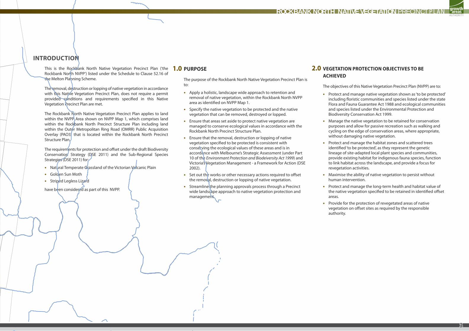
INTROduCTIONThis is the Rockbank North Native Vegetation Precinct Plan (‘the Rockbank North NVPP’) listed under the Schedule to Clause 52.16 of the Melton Planning Scheme.
The removal, destruction or lopping of native vegetation in accordance with this Native Vegetation Precinct Plan, does not require a permit provided conditions and requirements specified in this Native Vegetation Precinct Plan are met.
The Rockbank North Native Vegetation Precinct Plan applies to land within the NVPP Area shown on NVPP Map 1, which comprises land within the Rockbank North Precinct Structure Plan including land within the Outer Metropolitan Ring Road (OMRR) Public Acquisition Overlay (PAO3) that is located within the Rockbank North Precinct Structure Plan.
The requirements for protection and offset under the draft Biodiversity Conservation Strategy (DSE 2011) and the Sub-Regional Species Strategies (DSE 2011) for:
• Natural Temperate Grassland of the Victorian Volcanic Plain
• Golden Sun Moth
• Striped Legless Lizard
have been considered as part of this NVPP.
1.0 PuRPOsE
The purpose of the Rockbank North Native Vegetation Precinct Plan is to:
• Apply a holistic, landscape wide approach to retention and removal of native vegetation, within the Rockbank North NVPP area as identified on NVPP Map 1.
• Specify the native vegetation to be protected and the native vegetation that can be removed, destroyed or lopped.
• Ensure that areas set aside to protect native vegetation are managed to conserve ecological values in accordance with the Rockbank North Precinct Structure Plan.
• Ensure that the removal, destruction or lopping of native vegetation specified to be protected is consistent with conserving the ecological values of these areas and is in accordance with Melbourne’s Strategic Assessment (under Part 10 of the Environmant Protection and Biodeiversity Act 1999) and Victoria’s Vegetation Management - a Framework for Action (DSE 2002).
• Set out the works or other necessary actions required to offset the removal, destruction or lopping of native vegetation.
• Streamline the planning approvals process through a Precinct wide landscape approach to native vegetation protection and management.
2.0 VEgETATION PROTECTION OBjECTIVEs TO BE ACHIEVEd
The objectives of this Native Vegetation Precinct Plan (NVPP) are to:
• Protect and manage native vegetation shown as ‘to be protected’ including floristic communities and species listed under the state Flora and Fauna Guarantee Act 1988 and ecological communities and species listed under the Environmental Protection and Biodiversity Conservation Act 1999.
• Manage the native vegetation to be retained for conservation purposes and allow for passive recreation such as walking and cycling on the edge of conservation areas, where appropriate, without damaging native vegetation.
• Protect and manage the habitat zones and scattered trees identified ‘to be protected’, as they represent the genetic lineage of site-adapted local plant species and communities, provide existing habitat for indigenous fauna species, function to link habitat across the landscape, and provide a focus for revegetation activities.
• Maximise the ability of native vegetation to persist without human intervention.
• Protect and manage the long-term health and habitat value of the native vegetation specified to be retained in identified offset areas.
• Provide for the protection of revegetated areas of native vegetation on offset sites as required by the responsible authority.
Western Freeway
Beattys Road
Taylors Road
Leak
es R
oad
Payn
es R
oad
Map 1 - Areas which the NVPP appliesrockbank north native vegetation precinct plan
1:20000 @ A31:10000 @ A1
0 100 200 300 400 500
ROCKBANKRAIL STATION
1
2
3
4
5
6
78
9
1011
12
13
R1 R2
R3
1416
15
1719
1820
24
21
22
2325
30
26
27
28
29
3132
33
34
35
R4
Kororoit Creek
Tarleton Road
36
22
Native Vegetation Precinct Plan AreaProperty Reference Number
OMR Reservation
ROCKBANK NORTH NATIVE VEGETATION PRECINCT PLAN
3

91011
13
8
7654 1615 14
12
3
217
1819
1
Western Freeway
Beattys Road
Kororoit Creek
Kororoit Creek
Tarleton Road
Taylors Road
Leak
es R
oad
Payn
es R
oad
Map 2 - Native vegetation to be protected & which can be removed rockbank north native vegetation precinct plan
1:20000 @ A31:10000 @ A1
0 100 200 300 400 500
ROCKBANKRAIL STATION
HZ27
HZ28
HZ32
H
HZ58
HZ60
HZ57
HZ54
HZ59
HZ65
HZ22
HZ88
HZ24
HZ30HZ29
HZ25
HZ84
HZ23
HZ 105
HZ86
HZ85
HZ61
HZ44
HZ69HZ68
HZ19
HZ50
HZ18
HZ43HZ45
HZ56
HZ52
HZ49
HZ46
HZ87
HZ20
HZ103
HZ51
HZ64
HZ53
HZ83
HZ81
HZ102
HZ82
HZ 41
HZ 42
HZ 39
HZ48
HZ62 HZ66
HZ 40
HZ112
HZ55
HZ38
HZ26
HZ35a
HZ35b
HZ27HZ34
HZ31
HZ37
HZ36
HZ33
1
2
3
4
5
6
78
9
1011
12
13
R1 R2
R3
1416
15
1719
1820
24
21
22
2325
30
26
27
28
29
3132
33
34
35
R4
Kororoit Creek36
HZ67
HZ47
HZ63
Native Vegetation Precinct Plan Area
Native vegetation to be protected
Native vegetation which can be removed
Property Reference Number
Scattered Trees to be protected22
Note: Where Map 2 does not show vegetation to
be retained or removed, these are areas where
there is no native vegetation unless an o�set area
has been located within this map unit.
OMR ReservationHZ116
HZ117
HZ115
HZ120
HZ119
HZ118
ROCKBANK NORTH NATIVE VEGETATION PRECINCT PLAN
4
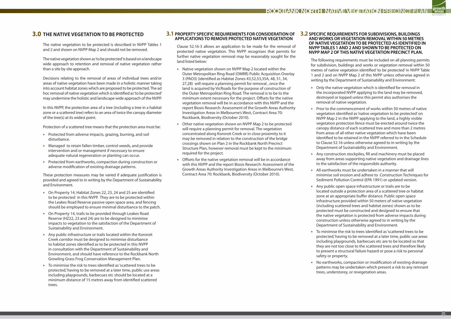
3.0 THE NATIVE VEgETATION TO BE PROTECTEd
The native vegetation to be protected is described in NVPP Tables 1 and 2 and shown on NVPP Map 2 and should not be removed.
The native vegetation shown as ‘to be protected’ is based on a landscape wide approach to retention and removal of native vegetation rather than a site by site approach.
Decisions relating to the removal of areas of individual trees and/or areas of native vegetation have been made in a holistic manner taking into account habitat zones which are proposed to be protected. The ad hoc removal of native vegetation which is identified as ‘to be protected’ may undermine the holistic and landscape wide approach of the NVPP.
In this NVPP, the protection area of a tree (including a tree in a habitat zone or a scattered tree) refers to an area of twice the canopy diameter of the tree(s) at its widest point.
Protection of a scattered tree means that the protection area must be:
• Protected from adverse impacts, grazing, burning, and soil disturbance.
• Managed to retain fallen timber, control weeds, and provide intervention and or management if necessary to ensure adequate natural regeneration or planting can occur.
• Protected from earthworks, compaction during construction or adverse modification of existing drainage patterns.
These protection measures may be varied if adequate justification is provided and agreed to in writing by the Department of Sustainability and Environment.
• On Property 14, Habitat Zones 22, 23, 24 and 25 are identified to be protected in this NVPP. They are to be protected within the Leakes Road Reserve passive open space area, and fencing should be employed to ensure minimal disturbance to the patch.
• On Property 14, trails to be provided through Leakes Road Reserve (HZ22, 23 and 24) are to be designed to minimise impacts to vegetation to the satisfaction of the Department of Sustainability and Environment.
• Any public infrastructure or trails located within the Kororoit Creek corridor must be designed to minimise disturbance to habitat zones identified as to be protected in this NVPP in consultation with the Department of Sustainability and Environment, and should have reference to the Rockbank North Growling Grass Frog Conservation Management Plan.
• To minimise the risk to trees identified as ‘scattered trees to be protected,’ having to be removed at a later time, public use areas including playgrounds, barbecues etc should be located at a minimum distance of 15 metres away from identified scattered trees.
3.1PROPeRTySPeCifiCReqUiRemeNTSfORCONSiDeRaTiONOfaPPliCaTiONSTORemOvePROTeCTeDNaTivevegeTaTiON
Clause 52.16-3 allows an application to be made for the removal of protected native vegetation. This NVPP recognises that permits for further native vegetation removal may be reasonably sought for the land listed below:
• Native vegetation shown on NVPP Map 2 located within the Outer Metropolitan Ring Road (OMRR) Public Acquisition Overlay 3 (PAO3) (identified as Habitat Zones 43,52,53,35A, 48, 51, 34, 27,28) will require a planning permit for removal , once the land is acquired by VicRoads for the purpose of construction of the Outer Metropolitan Ring Road. The removal is to be to the minimum extent necessary for the project. Offsets for the native vegetation removal will be in accordance with this NVPP and the report Biosis Research: Assessment of the Growth Areas Authority Investigation Areas in Melbourne’s West, Contract Area 70: Rockbank, Biodiversity (October 2010).
• Other native vegetation shown on NVPP Map 2 to be protected will require a planning permit for removal. The vegetation concentrated along Kororoit Creek or in close proximity to it may be removed in relation to the construction of the bridge crossings shown on Plan 2 in the Rockbank North Precinct Structure Plan, however removal must be kept to the minimum required for the project.
• Offsets for the native vegetation removal will be in accordance with this NVPP and the report Biosis Research: Assessment of the Growth Areas Authority Investigation Areas in Melbourne’s West, Contract Area 70: Rockbank, Biodiversity (October 2010).
3.2SPeCifiCReqUiRemeNTSfORSUbDiviSiONS,bUilDiNgSaNDwORkSORvegeTaTiONRemOvalwiThiN50meTReSOfNaTivevegeTaTiONTObePROTeCTeDaSiDeNTifieDiNNvPPTableS1aND2aNDShOwNTObePROTeCTeDONNvPPmaP2OfThiSNaTivevegeTaTiONPReCiNCTPlaN.
The following requirements must be included on all planning permits for subdivision, buildings and works or vegetation removal within 50 metres of native vegetation identified ‘to be protected’ in NVPP Table 1 and 2 and on NVPP Map 2 of this NVPP unless otherwise agreed in writing by the Department of Sustainability and Environment:
• Only the native vegetation which is identified for removal in the incorporated NVPP applying to the land may be removed, destroyed or lopped unless this permit also authorises the removal of native vegetation.
• Prior to the commencement of works within 50 metres of native vegetation identified as ‘native vegetation to be protected’ on NVPP Map 2 in the NVPP applying to the land, a highly visible vegetation protection fence must be erected around twice the canopy distance of each scattered tree and more than 2 metres from areas of all other native vegetation which have been identified to be retained in the NVPP referred to in the Schedule to Clause 52.16 unless otherwise agreed to in writing by the Department of Sustainability and Environment.
• Any construction stockpiles, fill and machinery must be placed away from areas supporting native vegetation and drainage lines to the satisfaction of the responsible authority.
• All earthworks must be undertaken in a manner that will minimise soil erosion and adhere to Construction Techniques for Sediment Pollution Control (EPA 1991) or updated version.
• Any public open space infrastructure or trails are to be located outside a protection area of a scattered tree or habitat zone at an appropriate buffer distance. Public open space infrastructure provided within 50 meters of native vegetation (including scattered trees and habitat zones) shown as to be protected must be constructed and designed to ensure that the native vegetation is protected from adverse impacts during construction unless otherwise agreed to in writing by the Department of Sustainability and Environment.
• To minimise the risk to trees identified as ‘scattered trees to be protected,’ having to be removed at a later time, public use areas including playgrounds, barbecues etc are to be located so that they are not too close to the scattered trees and therefore likely to present a structural failure hazard or pose a risk to personal safety or property.
• No earthworks, compaction or modification of existing drainage patterns may be undertaken which present a risk to any remnant trees, understorey, or revegetation areas.
ROCKBANK NORTH NATIVE VEGETATION PRECINCT PLAN
5
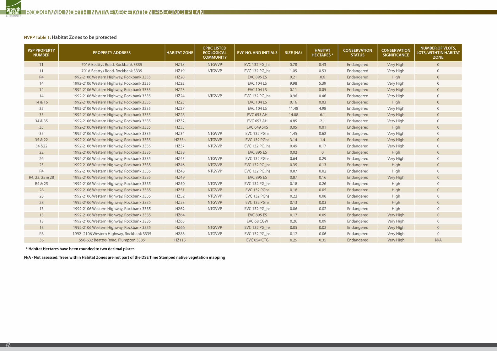
NvPPTable1:habitatZonestobeprotected
PSPPROPeRTyNUmbeR PROPeRTyaDDReSS habiTaTZONe
ePbCliSTeDeCOlOgiCalCOmmUNiTy
evCNO.aNDiNiTialS SiZe(ha) habiTaTheCTaReS*
CONSeRvaTiONSTaTUS
CONSeRvaTiONSigNifiCaNCe
NUmbeROfvlOTS,lOTS,wiThTiNhabiTaT
ZONe
11 701A Beattys Road, Rockbank 3335 HZ18 NTGVVP EVC 132 PG_hs 0.78 0.43 Endangered Very High 011 701A Beattys Road, Rockbank 3335 HZ19 NTGVVP EVC 132 PG_hs 1.05 0.53 Endangered Very High 0R4 1992-2106 Western Highway, Rockbank 3335 HZ20 EVC 895 ES 0.21 0.6 Endangered High 014 1992-2106 Western Highway, Rockbank 3335 HZ22 EVC 104 LS 9.98 5.39 Endangered Very High 014 1992-2106 Western Highway, Rockbank 3335 HZ23 EVC 104 LS 0.11 0.05 Endangered Very High 014 1992-2106 Western Highway, Rockbank 3335 HZ24 NTGVVP EVC 132 PG_hs 0.96 0.46 Endangered Very High 0
14 & 16 1992-2106 Western Highway, Rockbank 3335 HZ25 EVC 104 LS 0.16 0.03 Endangered High 035 1992-2106 Western Highway, Rockbank 3335 HZ27 EVC 104 LS 11.48 4.98 Endangered Very High 035 1992-2106 Western Highway, Rockbank 3335 HZ28 EVC 653 AH 14.08 6.1 Endangered Very High 0
34 & 35 1992-2106 Western Highway, Rockbank 3335 HZ32 EVC 653 AH 4.85 2.1 Endangered Very High 035 1992-2106 Western Highway, Rockbank 3335 HZ33 EVC 649 SKS 0.05 0.01 Endangered High 035 1992-2106 Western Highway, Rockbank 3335 HZ34 NTGVVP EVC 132 PGhs 1.45 0.62 Endangered Very High 0
35 & 22 1992-2106 Western Highway, Rockbank 3335 HZ35a NTGVVP EVC 132 PGhs 3.14 1.4 Endangered Very High 034 &22 1992-2106 Western Highway, Rockbank 3335 HZ37 NTGVVP EVC 132 PG_hs 0.49 0.17 Endangered Very High 0
22 1992-2106 Western Highway, Rockbank 3335 HZ38 EVC 895 ES 0.02 0 Endangered High 026 1992-2106 Western Highway, Rockbank 3335 HZ43 NTGVVP EVC 132 PGhs 0.64 0.29 Endangered Very High 025 1992-2106 Western Highway, Rockbank 3335 HZ46 NTGVVP EVC 132 PG_hs 0.35 0.13 Endangered High 0R4 1992-2106 Western Highway, Rockbank 3335 HZ48 NTGVVP EVC 132 PG_hs 0.07 0.02 Endangered High 0
R4, 23, 25 & 28 1992-2106 Western Highway, Rockbank 3335 HZ49 EVC 895 ES 0.87 0.16 Endangered Very High 0R4 & 25 1992-2106 Western Highway, Rockbank 3335 HZ50 NTGVVP EVC 132 PG_hs 0.18 0.26 Endangered High 0
28 1992-2106 Western Highway, Rockbank 3335 HZ51 NTGVVP EVC 132 PGhs 0.18 0.05 Endangered High 028 1992-2106 Western Highway, Rockbank 3335 HZ52 NTGVVP EVC 132 PGhs 0.22 0.08 Endangered High 028 1992-2106 Western Highway, Rockbank 3335 HZ53 NTGVVP EVC 132 PGhs 0.13 0.03 Endangered High 013 1992-2106 Western Highway, Rockbank 3335 HZ62 NTGVVP EVC 132 PG_hs 0.06 0.02 Endangered High 013 1992-2106 Western Highway, Rockbank 3335 HZ64 EVC 895 ES 0.17 0.09 Endangered Very High 013 1992-2106 Western Highway, Rockbank 3335 HZ65 EVC 68 CGW 0.26 0.09 Endangered Very High 013 1992-2106 Western Highway, Rockbank 3335 HZ66 NTGVVP EVC 132 PG_hs 0.05 0.02 Endangered Very High 0R3 1992 -2106 Western Highway, Rockbank 3335 HZ83 NTGVVP EVC 132 PG_hs 0.12 0.06 Endangered Very High 036 598-632 Beattys Road, Plumpton 3335 HZ115 EVC 654 CTG 0.29 0.35 Endangered Very High N/A
*habitathectareshavebeenroundedtotwodecimalplaces
N/a-Notassessed:TreeswithinhabitatZonesarenotpartoftheDSeTimeStampednativevegetationmapping
ROCKBANK NORTH NATIVE VEGETATION PRECINCT PLAN
6
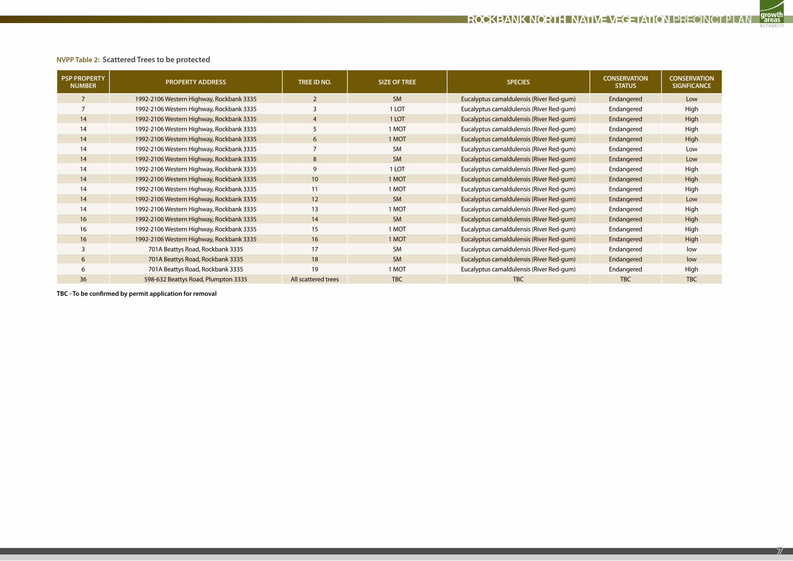
NvPPTable2:ScatteredTreestobeprotected
PSPPROPeRTyNUmbeR PROPeRTyaDDReSS TReeiDNO. SiZeOfTRee SPeCieS CONSeRvaTiON
STaTUSCONSeRvaTiON
SigNfiCaNCe
7 1992-2106 Western Highway, Rockbank 3335 2 SM Eucalyptus camaldulensis (River Red-gum) Endangered Low7 1992-2106 Western Highway, Rockbank 3335 3 1 LOT Eucalyptus camaldulensis (River Red-gum) Endangered High
14 1992-2106 Western Highway, Rockbank 3335 4 1 LOT Eucalyptus camaldulensis (River Red-gum) Endangered High14 1992-2106 Western Highway, Rockbank 3335 5 1 MOT Eucalyptus camaldulensis (River Red-gum) Endangered High14 1992-2106 Western Highway, Rockbank 3335 6 1 MOT Eucalyptus camaldulensis (River Red-gum) Endangered High14 1992-2106 Western Highway, Rockbank 3335 7 SM Eucalyptus camaldulensis (River Red-gum) Endangered Low14 1992-2106 Western Highway, Rockbank 3335 8 SM Eucalyptus camaldulensis (River Red-gum) Endangered Low14 1992-2106 Western Highway, Rockbank 3335 9 1 LOT Eucalyptus camaldulensis (River Red-gum) Endangered High14 1992-2106 Western Highway, Rockbank 3335 10 1 MOT Eucalyptus camaldulensis (River Red-gum) Endangered High14 1992-2106 Western Highway, Rockbank 3335 11 1 MOT Eucalyptus camaldulensis (River Red-gum) Endangered High14 1992-2106 Western Highway, Rockbank 3335 12 SM Eucalyptus camaldulensis (River Red-gum) Endangered Low14 1992-2106 Western Highway, Rockbank 3335 13 1 MOT Eucalyptus camaldulensis (River Red-gum) Endangered High16 1992-2106 Western Highway, Rockbank 3335 14 SM Eucalyptus camaldulensis (River Red-gum) Endangered High16 1992-2106 Western Highway, Rockbank 3335 15 1 MOT Eucalyptus camaldulensis (River Red-gum) Endangered High16 1992-2106 Western Highway, Rockbank 3335 16 1 MOT Eucalyptus camaldulensis (River Red-gum) Endangered High3 701A Beattys Road, Rockbank 3335 17 SM Eucalyptus camaldulensis (River Red-gum) Endangered low6 701A Beattys Road, Rockbank 3335 18 SM Eucalyptus camaldulensis (River Red-gum) Endangered low6 701A Beattys Road, Rockbank 3335 19 1 MOT Eucalyptus camaldulensis (River Red-gum) Endangered High
36 598-632 Beattys Road, Plumpton 3335 All scattered trees TBC TBC TBC TBC
TbC-Tobeconfirmedbypermitapplicationforremoval
ROCKBANK NORTH NATIVE VEGETATION PRECINCT PLAN
7

4.0 NATIVE VEgETATION wHICH CAN BE REmOVEd, dEsTROyEd OR lOPPEd
The native vegetation described in NVPP Table 3 and 4 and shown on NVPP Map 2 can be removed, destroyed or lopped, subject to the requirements and conditions set out below as allowed under Clause 52.16 of the Melton Planning Scheme.
Note: In accordance with the note on NVPP Map 2, where Map 2 does not show vegetation to be retained or removed, these are areas where there is no native vegetation unless an offset area has been located within this map unit. In this instance a planning permit is not required, nor are there any conditions or requirements associated with the removal, destruction or lopping of any native vegetation.
The Rockbank North NVPP area contains suitable habitat for Striped Legless Lizard (Delmat impar) and Golden Sun Moth. The requirements of the Biodiversity Conservation Strategy for these species requires that where native vegetation that is habitat is removed then it must be offset, and salvage and translocation of the Striped Legless Lizard must occur.
4.1CONDiTiONSfORRemOvalOfNaTivevegeTaTiON
The native vegetation described in Table 3 and 4 and shown in Map 2 as native vegetation that ‘can be removed’, can be removed, destroyed or lopped subject to the following conditions.
• Only the native vegetation which is identified for removal in the incorporated Rockbank North NVPP applying to the land may be removed, destroyed or lopped without a planning permit.
• The native vegetation (habitat zones or scattered trees) which is shown as vegetation which can be removed in Table 3 and 4 and Map 2 of this Native Vegetation Precinct Plan may be removed if the removal of the native vegetation is offset in accordance with the offset targets set out in Table 5 and 6 of the Native Vegetation Precinct Plan and those offsets are secured to the satisfaction of the Department of Sustainability and Environment and the responsible authority.
• Where large old trees (LOTs,) very large old trees (VLOTs) and offsets are not identified (or marked as ‘TBC’) in Table 5, the person proposing to remove, destroy or lop the habitat zone must submit to the responsible authority a description of the number and size of each VLOT and LOT within the relevant habitat zone in order to determine the offset for that habitat zone in accordance with the Victoria’s Native Vegetation Management – A Framework for Action, DSE 2002 and Port Phillip & Westernport Catchment Management Authority, 2006.
• Before the removal, destruction or lopping of any native vegetation within any property (identified by the PSP property number in NVPP Map 2 of the Rockbank North NVPP) the owner of the land from which the native vegetation is being removed must provide offsets consistent with this NVPP by either: • Providing an allocated credit extract issued by the
Department of Sustainability and Environment; or • Preparing and submitting an Offset Plan to the satisfaction of
the Department of Sustainability and Environment and have the Offset plan approved by the responsible authority.
• Where an Offset plan is approved: • Before the removal, destruction or lopping of any native
vegetation, the owner of the land from which the native vegetation is being removed must provide on-title security for the Offset Site to the satisfaction of the Department of Sustainability and Environment that provides for the implementation of the Offset Plan and pay the reasonable costs of the preparation, execution and registration of any on-title agreement; and
• Offsets must be initiated within 12 months of approval of the Offset Plan or before the removal of Very High Conservation Significance vegetation, whichever is earlier and be implemented according to the schedule of works in the Offset Plan to the satisfaction of the responsible authority. A separate agreement for the offsets within the PAO (VicRoads)
may be entered into by VicRoads and the Department of Sustainability and Environment.
• Prior to the removal of any vegetation, offsets for Golden Sun Moth habitat on land must be provided to the satisfaction of the Department of Sustainability and Environment.
• Prior to the removal of any native vegetation, a contributory habitat fee for Spiny Rice Flower must be provided to the satisfaction of the Department of Sustainability and Environment.
• Prior to the removal of any native vegetation, a contributory habitat fee for Matted Flax Lily must be provided to the satisfaction of the Department of Sustainability and Environment.
• Prior to the removal of any vegetation a contributory habitat fee for Growling Grass Frog Category 2 habitat on the land must be provided to the satisfaction of the Department of Sustainability and Environment.
• Prior to the removal of any vegetation offsets for Striped Legless Lizard habitat on the land must be provided to the satisfaction of the Department of Sustainability and Environment.
• The Salvage and Translocation of Striped Legless Lizard in the Urban Growth Areas of Melbourne: Strategic Approach (DSE 2011) and Salvage and Translocation of Striped Legless Lizard in the Urban Growth Areas of Melbourne: Operational Plan (DSE 2011) must be implemented to the satisfaction of the Secretary of the Department of Sustainability and Environment before during and after the carrying out of any buildings or works or native vegetation removal and all specifications and requirements of the approved plan must be complied with.
• Before the removal, destruction or lopping of any native vegetation, native vegetation to be removed in accordance with this NVPP must be clearly marked on site to the satisfaction of the responsible authority whilst works are being undertaken within the vicinity.
• Before the felling of any trees with nest or hollows the tree must be examined for fauna by a suitably qualified zoologist. If native fauna species are found, they must be salvaged and relocated where possible to the nearest suitable habitat, in consultation with the Department of Sustainability and Environment.
• Any construction stockpiles, fill and machinery must be placed away from areas supporting native vegetation to be protected and drainage lines to the satisfaction of the responsible authority.
• Prior to the commencement of any works including vegetation removal, a highly visible vegetation protection fence must be erected around twice the canopy distance of each scattered tree and more than 2 metres from areas of all other native vegetation which has been identified to be protected in the Native Vegetation Precinct Plan referred to in the Schedule to Clause 52.16 unless otherwise agreed to in writing by the Department of Sustainability and Environment and to the satisfaction of the responsible authority.
ROCKBANK NORTH NATIVE VEGETATION PRECINCT PLAN
8

4.2ReqUiRemeNTSfORRemOvalOfNaTivevegeTaTiON
Offsets must be provided in accordance with Victoria’s Native Vegetation Management, a Framework for Action DSE 2002.
• An Offset Plan must show offsets in relation to all native vegetation within the property which this NVPP allows to be removed. The offsets are to be as set out in this NVPP. An Offset Plan must be prepared in accordance with the Department of Sustainability and Environment Offset Plan Template available from the Department of Sustainability and Environment.
• An offset site must be secured through an appropriate mechanism to the satisfaction of the Department of Sustainability and Environment. Where an offset is secured via an agreement, the agreement must be registered on the title of the land and provide for a native vegetation offset in accordance with the endorsed offset plan.
• The offset requirements for native vegetation which can be removed, destroyed or lopped as described in Table 3 and 4 are set out in Table 5 and 6.
• Note: There are a range of mechanisms for offsetting loss of native vegetation including an on-title agreement, transfer of land to public land, or Crown land. Examples of on title agreements are: a Section 173 Agreement under the Planning and Environment Act 1987, a Section 69 of the Conservation Forest and Lands Act 1987 or a Trust for Nature Covenant under the Victorian Conservation Trust Act 1972.
4.3PROCeDUReSfORTheCOlleCTiONOfaNyPaymeNTS
No payments are necessary or specified.
ROCKBANK NORTH NATIVE VEGETATION PRECINCT PLAN
9

Table3:habitatZoneswhichcanberemoved
PSPPROPeRTyNUmbeR PROPeRTyaDDReSS habiTaTZONeiD evCNO.aNDiNiTialS SiZe(ha)
ePbCliSTeDeCOlOgiCalCOmmUNiTy
NUmbeROfvlOTS,lOTS,wiThTiNhabiTaTZONe
34 1992-2106 Western Highway, Rockbank 3335 HZ26 EVC 132 PG_hs 0.97 NTGVVP 014 & 15 1992-2106 Western Highway, Rockbank 3335 HZ29 EVC 132 PGhs 0.3 NTGVVP 0
14 1992-2106 Western Highway, Rockbank 3335 HZ30 EVC 132 PGhs 0.74 NTGVVP 034 1992-2106 Western Highway, Rockbank 3335 HZ31 EVC 132 PGhs 0.89 NTGVVP 035 1992-2106 Western Highway, Rockbank 3335 HZ35b EVC 132 PGhs 1.95 NTGVVP 035 1992-2106 Western Highway, Rockbank 3335 HZ36 EVC 132 PGhs 0.11 NTGVVP 020 886-940 Beattys Road, Rockbank 3335 HZ39 EVC 649 SKS 0.07 020 1992-2106 Western Highway, Rockbank 3335 HZ40 EVC 132 PGlr 0.04 021 1992-2106 Western Highway, Rockbank 3335 HZ41 EVC 649 SKS 0.09 022 1992-2106 Western Highway, Rockbank 3335 HZ42 EVC 649 SKS 0.09 026 1992-2106 Western Highway, Rockbank 3335 HZ44 EVC 132 PGhs 1.63 NTGVVP 026 1992-2106 Western Highway, Rockbank 3335 HZ45 EVC 132 PGhs 0.54 NTGVVP 012 1992- 2106 Western Highway, Rockbank 3335 HZ47 EVC 132 PGhs 0.03 NTGVVP 013 1992-2106 Western Highway, Rockbank 3335 HZ54 EVC 132 PGhs 0.25 NTGVVP 012 1992-2106 Western Highway, Rockbank 3335 HZ55 EVC 132 PGhs 0.02 NTGVVP 012 1992-2106 Western Highway, Rockbank 3335 HZ56 EVC 132 PG_hs 0.41 NTGVVP 0
12 &13 1992-2106 Western Highway, Rockbank 3335 HZ57 EVC 132 PGhs 0.31 NTGVVP 013 1992-2106 Western Highway, Rockbank 3335 HZ58 EVC 132 PGhs 1.32 NTGVVP 013 1992-2106 Western Highway, Rockbank 3335 HZ60 EVC 132 PGhs 0.57 NTGVVP 012 1992-2106 Western Highway, Rockbank 3335 HZ61 EVC 132 PGhs 2.69 NTGVVP 013 1992-2106 Western Highway, Rockbank 3335 HZ63 EVC 132 PGhs 0.02 NTGVVP 012 1992 -2106 Western Highway, Rockbank 3335 HZ67 EVC 132 PGhs 0.42 NTGVVP 013 1992-2106 Western Highway, Rockbank 3335 HZ68 EVC 132 PGhs 0.28 NTGVVP 013 1992-2106 Western Highway, Rockbank 3335 HZ69 EVC 132 PGhs 1.11 NTGVVP 0R3 1992-2106 Western Highway, Rockbank 3335 HZ81 EVC 132 PGhs 0.11 NTGVVP 0R3 1992-2106 Western Highway, Rockbank 3335 HZ82 EVC 132 PGhs 0.11 NTGVVP 0R3 1992-2106 Western Highway, Rockbank 3335 HZ84 EVC 132 PGhs 0.12 NTGVVP 0R3 1992-2106 Western Highway, Rockbank 3335 HZ85 EVC 132 PGhs 0.02 NTGVVP 0R3 1992-2106 Western Highway, Rockbank 3335 HZ86 EVC 132 PGhs 0.05 NTGVVP 0R3 1992-2106 Western Highway, Rockbank 3335 HZ87 EVC 132 PGhs 0.32 NTGVVP 0R3 1992-2106 Western Highway, Rockbank 3335 HZ88 EVC 132 PGhs 1.41 NTGVVP 0R3 1992-2106 Western Highway, Rockbank 3335 HZ102 EVC 132 PGhs 0.13 NTGVVP 0R3 1992-2106 Western Highway, Rockbank 3335 HZ103 EVC 132 PGhs 0.35 NTGVVP 0R1 1992-2106 Western Highway, Rockbank 3335 HZ105 EVC 132 PGhs 0.08 NTGVVP 036 598-632 Beattys Road, Plumpton 3335 HZ 116 EVC 132 PGhs 0.07 N/A36 598-632 Beattys Road, Plumpton 3335 HZ117 EVC 132 PGhs 0.25 N/A36 598-632 Beattys Road, Plumpton 3335 HZ118 EVC 132 PGhs 0.09 N/A36 598-632 Beattys Road, Plumpton 3335 HZ119 EVC 132 PGhs 0.05 N/A36 598-632 Beattys Road, Plumpton 3335 HZ120 EVC 132 PGhs 0.36 N/A
Table4:Scatteredtreeswhichcanberemoved
PSPPROPeRTyNUmbeR PROPeRTyaDDReSS TRee
iDNO. SPeCieS SiZeOfTRee(vlOT,lOT,mOT) evCDeSCRiPTiON CONSeRvaTiON
STaTUSCONSeRvaTiONSigNifiCaNCe
y-lONgiTUDe
X-laTiTUDe
14 1992-2106 Western Highway, Rockbank 3335 13 Eucalyptus camaldulensis (River Red-gum) MOT EVC 55 PGW Endangered High 2469957 2420760
TbC-Tobeconfirmed:seesection4.1ConditionsforRemovalofNativevegetation
ROCKBANK NORTH NATIVE VEGETATION PRECINCT PLAN
10

Table5:OffsetRequirementsforhabitatZonestoberemoved
PSPPROPeRTyNUmbeR
PROPeRTyaDDReSS habiTaTZONe
evCNO.&iNiTialS
CONSeRvaTiONSTaTUS
CONSeRvaTiONSigNfiCaNCe
habiTaTSCORe
lOSS(habiTaT
heCTaReS)*
lOSSOfvlOTSaND
lOTSwiThiNhabiTaT
ZONe
likefORlikeReqUiRemeNTS
(evCORThReaTeNeD
SPeCieS)
NeTgaiNmUlTiPlieR
**
gaiNTaRgeT(habiTaT
heCTaReS)OffSeTTObe
aChieveD
OffSeTTObeaChieveD
fORlOTS:ReCRUiTmeNT/RevegeTaTiON
OffSeTTObeaChieveD
fORlOTS:PROTeCTiONOf
TReeSTaRgeT
34 1992-2106 Western Highway, Rockbank 3335 HZ26 EVC 132 PGhs Endangered High 25 0.34 0 NTG Offset to WGR 1.5 0.51 0 0
14 & 15 1992-2106 Western Highway, Rockbank 3335 HZ29 EVC 132 PGhs Endangered High 35 0.10 0 NTG Offset to WGR 1.5 0.14 0 0
14 1992-2106 Western Highway, Rockbank 3335 HZ30 EVC 132 PGhs Endangered High 30 0.24 0 NTG Offset to WGR 1.5 0.35 0 0
34 1992-2106 Western Highway, Rockbank 3335 HZ31 EVC 132 PGhs Endangered High 39 0.26 0 NTG Offset to WGR 1.5 0.39 0 0
35 1992-2106 Western Highway, Rockbank 3335 HZ35b EVC 132 PGhs Endangered Very High 46 0.90 0 NTG Offset to WGR 2 1.80 0 0
35 1992-2106 Western Highway, Rockbank 3335 HZ36 EVC 132 PGhs Endangered High 27 0.03 0 NTG Offset to WGR 1.5 0.05 0 0
12 886-940 Beattys Road, Rockbank 3335 HZ39 EVC 649 SKS Endangered High 28 0.02 0 EVC 649 SKS 1.5 0.03 0 0
20 1992-2106 Western Highway, Rockbank 3335 HZ40 EVC 132 PGhs Endangered High 29 0.01 0 NTG Offset to WGR 1.5 0.02 0 0
21 1992-2106 Western Highway, Rockbank 3335 HZ41 EVC 649 SKS Endangered High 18 0.02 0 EVC 649 SKS 1.5 0.03 0 0
22 1992-2106 Western Highway, Rockbank 3335 HZ42 EVC 649 SKS Endangered High 21 0.03 0 EVC 649 SKS 1.5 0.05 0 0
26 1992-2106 Western Highway, Rockbank 3335 HZ43 EVC 132 PGhs Endangered Very High 44 0.29 0 NTG Offset to WGR 2 0.58 0 0
26 1992-2106 Western Highway, Rockbank 3335 HZ44 EVC 132 PGhs Endangered Very High 44 0.74 0 NTG Offset to WGR 2 1.48 0 0
26 1992-2106 Western Highway, Rockbank 3335 HZ45 EVC 132 PGhs Endangered Very High 42 0.23 0 NTG Offset to WGR 2 0.46 0 0
12 1992 -2106 Western Highway, Rockbank 3335 HZ47 EVC 132 PGhs Endangered Very High 43 0.01 0 NTG Offset to WGR 2 0.03 0 0
13 1992-2106 Western Highway, Rockbank 3335 HZ54 EVC 132 PGhs Endangered Very High 43 0.10 0 NTG Offset to WGR 2 0.20 0 0
12 1992-2106 Western Highway, Rockbank 3335 HZ55 EVC 132 PGhs Endangered High 28 0.01 0 NTG Offset to WGR 1.5 0.02 0 0
12 1992-2106 Western Highway, Rockbank 3335 HZ56 EVC 132 PGhs Endangered High 32 0.12 0 NTG Offset to WGR 1.5 0.18 0 0
12 & 13 1992-2106 Western Highway, Rockbank 3335 HZ57 EVC 132 PGhs Endangered Very High 48 0.13 0 NTG Offset to WGR 2 0.26 0 0
13 1992-2106 Western Highway, Rockbank 3335 HZ58 EVC 132 PGhs Endangered High 38 0.48 0 NTG Offset to WGR 1.5 0.72 0 0
13 1992-2106 Western Highway, Rockbank 3335 HZ60 EVC 132 PGhs Endangered Very High 43 0.24 0 NTG Offset to WGR 2 0.48 0 0
12 1992-2106 Western Highway, Rockbank 3335 HZ61 EVC 132 PGhs Endangered High 21 0.55 0 NTG Offset to WGR 1.5 0.82 0 0
13 1992-2106 Western Highway, Rockbank 3335 HZ63 EVC 132 PGhs Endangered High 38 0.01 0 NTG Offset to WGR 1.5 0.02 0 0
12 1992-2106 Western Highway, Rockbank 3335 HZ67 EVC 132 PGhs Endangered Very High 36 0.15 0 NTG Offset to WGR 2 0.30 0 0
13 1992-2106 Western Highway, Rockbank 3335 HZ68 EVC 132 PGhs Endangered High 38 0.10 0 NTG Offset to WGR 1.5 0.16 0 0
13 1992-2106 Western Highway, Rockbank 3335 HZ69 EVC 132 PGhs Endangered High 21 0.23 0 NTG Offset to WGR 1.5 0.34 0 0
R3 1992-2106 Western Highway, Rockbank 3335 HZ81 EVC 132 PGhs Endangered Very High 42 0.04 0 NTG Offset to WGR 2 0.08 0 0
R3 1992-2106 Western Highway, Rockbank 3335 HZ82 EVC 132 PGhs Endangered Very High 49 0.06 0 NTG Offset to WGR 2 0.12 0 0
R3 1992-2106 Western Highway, Rockbank 3335 HZ84 EVC 132 PGhs Endangered High 31 0.04 0 NTG Offset to WGR 1.5 0.06 0 0
ROCKBANK NORTH NATIVE VEGETATION PRECINCT PLAN
11

PSPPROPeRTyNUmbeR
PROPeRTyaDDReSS habiTaTZONe
evCNO.&iNiTialS
CONSeRvaTiONSTaTUS
CONSeRvaTiONSigNfiCaNCe
habiTaTSCORe
lOSS(habiTaT
heCTaReS)*
lOSSOfvlOTSaND
lOTSwiThiNhabiTaT
ZONe
likefORlikeReqUiRemeNTS
(evCORThReaTeNeD
SPeCieS)
NeTgaiNmUlTiPlieR
**
gaiNTaRgeT(habiTaT
heCTaReS)OffSeTTObe
aChieveD
OffSeTTObeaChieveD
fORlOTS:ReCRUiTmeNT/RevegeTaTiON
OffSeTTObeaChieveD
fORlOTS:PROTeCTiONOf
TReeSTaRgeT
R3 1992-2106 Western Highway, Rockbank 3335 HZ85 EVC 132 PGhs Endangered High 31 0.01 0 NTG Offset to WGR 1.5 0.02 0 0
R3 1992-2106 Western Highway, Rockbank 3335 HZ86 EVC 132 PGhs Endangered High 42 0.02 0 NTG Offset to WGR 1.5 0.03 0 0
R3 1992-2106 Western Highway, Rockbank 3335 HZ87 EVC 132 PGhs Endangered Very High 39 0.14 0 NTG Offset to WGR 2 0.28 0 0
R3 1992-2106 Western Highway, Rockbank 3335 HZ88 EVC 132 PGhs Endangered High 40 0.55 0 NTG Offset to WGR 1.5 0.83 0 0
R3 1992-2106 Western Highway, Rockbank 3335 HZ102 EVC 132 PGhs Endangered High 32 0.04 0 NTG Offset to WGR 1.5 0.06 0 0
R3 1992-2106 Western Highway, Rockbank 3335 HZ103 EVC 132 PGhs Endangered Very High 46 0.16 0 NTG Offset to WGR 2 0.32 0 0
R1 1992-2106 Western Highway, Rockbank 3335 HZ105 EVC 132 PGhs Endangered Very High 41 0.03 0 NTG Offset to WGR 2 0.06 0 0
36 598-632 Beattys Road, Plumpton 3335 HZ116 EVC 132 PGhs Endangered Very High 25 0.02 TBC NTG Offset to WGR 2 0.04 TBC TBC36 598-632 Beattys Road, Plumpton 3335 HZ117 EVC 132 PGhs Endangered Very High 35 0.09 TBC NTG Offset to WGR 2 0.18 TBC TBC36 598-632 Beattys Road, Plumpton 3335 HZ118 EVC 132 PGhs Endangered Very High 25 0.02 TBC NTG Offset to WGR 2 0.04 TBC TBC36 598-632 Beattys Road, Plumpton 3335 HZ119 EVC 132 PGhs Endangered Very High 25 0.01 TBC NTG Offset to WGR 2 0.02 TBC TBC36 598-632 Beattys Road, Plumpton 3335 HZ120 EVC 132 PGhs Endangered Very High 25 0.07 TBC NTG Offset to WGR 2 0.14 TBC TBC
**NetgainTargetshavebeencalculatedontheunroundedhabitathectarefigureandthenroundedtotwodecimalplaces
*habitathectareshavebeenroundedtotwodecimalplaces
TbC-TobeConfirmed(Seesection4.1ConditionsforRemovalofNativevegetation)
Table5:OffsetRequirementsforhabitatZonestoberemoved(continued)
Table6:OffsetRequirementsforscatteredtreeswhichmayberemoved
PSPPROPeRTyNUmbeR PROPeRTyaDDReSS(iNClUDiNgTiTleNUmbeR) CONSeRvaTiON
STaTUSCONSeRvaTiONSigNifiCaNCe
lOSS:NO.OfveRylaRge
OlDTReeS(iNClTReeNUmbeR)
lOSS:NO.OflaRgeOlDTReeS(iNClTReeNUmbeR)
lOSS:NO.OfmeDiUmOlD
TReeS(iNClTReeNUmbeR)
lOSS:NO.OfSmallTReeS
OffSeTTObeaChieveD
ReCRUiTmeNT/RevegeTaTiON
TaRgeT
OffSeTTObeaChieveDPROTeCTiON
OfTReeSTaRgeT
14 1992-2106 Western Highway, Rockbank 3335 Endangered High 0 0 1 0 Recruit 20 new trees
Protect 2 medium old
trees and recruit 20 new plants
ROCKBANK NORTH NATIVE VEGETATION PRECINCT PLAN
12
5.0 REfERENCE dOCumENT
Assessment of the Growth Areas Authority Investigation Areas in Melbourne’s West: - Biosis Research Assessment Report- Contract Area 70: Rockbank (Biosis 2010).
Draft Biodiversity Conservation Strategy for Melbourne’s Growth Areas, (DES November 2011)
Time Stamping Native Vegetation Data (DSE November 2011)
6.0 ACRONyms
AH – Aquatic Herbland
CGW – Creekline Grassy Woodland
CTG - Creekline Tussock Grassland
EVC – Ecological Vegetation Class
EPBC Act – Environment Protection and Biodiversity Act 1999 (cwlth)
ES – Escarpment Shrubland
Ha – Hectares
Hha – Habitat Hectares
HZ – Habitat Zone
Lot – Large Old Tree
LS – Lignum Swamp
NTGVVP – Natural Temperate Grasslands of the Victorian Volcanic Plain
NVPP – Native Vegetation Precinct Plan
PGhs – Plains Grassland Heavier Soils
PG - Plains Grassland
SKS – Stony Knoll Shrubland
TBC - To be confirmed
VLOT – Very Large Old Tree
ROCKBANK NORTH NATIVE VEGETATION PRECINCT PLAN
13

Growth Areas Authority Level 29, 35 Collins Street MELBOURNE VIC 3000www.gaa.vic.gov.au
partners in creating new communities