Rock slope stability Draft - University of Toronto T-Space · Open pit slope failure, Runout...
65
Draft Runout analysis and mobility observations for large open pit slope failures Journal: Canadian Geotechnical Journal Manuscript ID cgj-2016-0255.R1 Manuscript Type: Article Date Submitted by the Author: 18-Jul-2016 Complete List of Authors: Whittall, John; BGC Engineering Inc., Eberhardt, E.; University of British Columbia, McDougall, Scott; University of British Columbia, Earth, Ocean and Atmospheric Sciences Keyword: Open pit slope failure, Runout analysis, Exclusion zones, Landslide mobility, Rock slope stability https://mc06.manuscriptcentral.com/cgj-pubs Canadian Geotechnical Journal
Transcript of Rock slope stability Draft - University of Toronto T-Space · Open pit slope failure, Runout...

Draft
Runout analysis and mobility observations for large open pit
slope failures
Journal: Canadian Geotechnical Journal
Manuscript ID cgj-2016-0255.R1
Manuscript Type: Article
Date Submitted by the Author: 18-Jul-2016
Complete List of Authors: Whittall, John; BGC Engineering Inc., Eberhardt, E.; University of British Columbia, McDougall, Scott; University of British Columbia, Earth, Ocean and Atmospheric Sciences
Keyword: Open pit slope failure, Runout analysis, Exclusion zones, Landslide mobility, Rock slope stability
https://mc06.manuscriptcentral.com/cgj-pubs
Canadian Geotechnical Journal

Draft
1
Runout analysis and mobility observations for large open pit slope
failures
John Whittall
BGC Engineering Inc.
Suite 500 – 980 Howe Street
Vancouver, BC V6Z 0C8
Canada
Erik Eberhardt
Geological Engineering, Department of Earth, Ocean, and Atmospheric Sciences
University of British Columbia
2020 – 2207 Main Mall
Vancouver, BC V6T 1Z4
Canada
Scott McDougall
Geological Engineering, Department of Earth, Ocean, and Atmospheric Sciences
University of British Columbia
2020 – 2207 Main Mall
Vancouver, BC V6T 1Z4
Canada
Page 1 of 64
https://mc06.manuscriptcentral.com/cgj-pubs
Canadian Geotechnical Journal

Draft
Abstract
Objectively forecasting the runout of a potential open pit slope failure, in addition to identifying the
failure itself, is a critical component of a mine’s risk management plan. Recent losses arising from
large open pit slope failures demonstrate shortcomings in current practice. A dataset of 105 pit
slope failures was compiled to compare open pit runout trends against established empirical
runout relationships for natural landslides. Fahrböschung angle vs. volume and Fahrböschung
angle vs. slope angle relationships provide reasonable runout estimates. Open pit slopes have the
advantage of removing the influence of morphological features, vegetation, and liquefiable
substrates while controlling the travel path angle and roughness. In such a controlled environment,
landslide mobility has a strong sensitivity to slope angle, material properties and fall height, and is
only modestly sensitive to volume. A grouping of highly mobile open pit slope cases involving
weathered, saturated, collapsible rock mass materials exceed expected runout distances when
compared to established runout trends. This suggests mobility for these weaker rock masses is
controlled by pore pressures mediating basal friction. The result is that two different runout
exceedance trends are observed based on whether the unstable rock mass involves fresh, strong
rocks or weathered weak rocks.
KEYWORDS: Open pit slope failure, rock slope stability, runout analysis, exclusion zones, landslide
mobility
Page 2 of 64
https://mc06.manuscriptcentral.com/cgj-pubs
Canadian Geotechnical Journal

Draft
3
Introduction
Recent large open pit slope failures that have caused significant damage to mine
infrastructure and equipment demonstrate shortcomings in current practices used to estimate
landslide runout and establish exclusion zones for an impending failure (e.g. Pankow et al. 2014;
Farina and Coli 2013). Objectively forecasting the zone of impact of a potential slope failure, in
addition to identifying the failure itself, is a critical component of a mine’s risk management plan,
yet few guidelines exist.
In the study of natural landslides empirical runout methods are commonly used to assess
runout potential (e.g., Scheidegger 1973; Hsü 1975; Li 1983; Corominas 1996; Iverson et al. 1998;
Fannin and Wise 2001; Hunter and Fell 2003). These methods are largely based on field
observations and on the analysis of the relationship between the source volume of the landslide
and the distance travelled by the debris. Empirical methods are quick, repeatable, and useful for
bracketing site conditions where detailed data is limited. The utility of these methods has been
recognized for open pit slope failures (Rose 2011), however, existing data sets have solely focused
on natural landslide case histories and have not been validated for open pit slope failures.
This paper presents a dataset of 105 extremely rapid (>5 m/s) open pit slope failures that
have been compiled, analyzed and compared against established empirical runout relationships for
natural landslides. Established methods are calibrated to an open pit context and evaluated
quantitatively using a cross validation procedure. A discussion of differences between open pit and
natural slope runouts highlights possible limitations to the application of these models to open pit
slopes, but also identifies useful trends. The absence of natural morphological features, vegetation,
and liquefiable substrates in open pits, which are common on natural slopes, also provides an
Page 3 of 64
https://mc06.manuscriptcentral.com/cgj-pubs
Canadian Geotechnical Journal

Draft
4
opportunity to assess their influences on runout distance, lateral spreading and deposit shape
through comparison of the different data sets.
Open pit slope failure database
A comprehensive public-domain literature search returned ninety-six open pit slope failures
that included a runout component, at over fifty different mines. Anonymous sources provided
another nine case histories, for a total of 105 open pit slope failures with a runout component.
These case histories are presented in a supplement to this paper. Whittall (2015) presents a
detailed accounting of each case. The authors infer from anecdotal evidence (the failures ran out)
that the landslide motion after detachment was very rapid to extremely rapid and are analogous to
Hungr et al.’s (2014) description of rock avalanches. Failures that did not runout, were <40,000 m3,
or were retained by effective slope management measures (e.g., Hamel 1970; Brawner 1971;
Newcomen and Martin 1988; Martin and Mehr 1993; Newcomen et al. 2003) were excluded from
the dataset. Failures where material funneled into collapse features above underground workings
related to block caving (e.g., Brummer et al. 2006) were also excluded.
If unspecified, volume estimates are assumed to represent in-place (i.e. un-bulked) source
volumes. Where references provide both in-place and bulked failure volumes, plots use the in-place
volume for consistency. Wherever possible, additional geometric estimates are taken from satellite
imagery, particularly: Google Earth Pro, NASA earth observatory, UNOSAT, Geoscience Australia,
ESRI, and hard copy aerial photographs.
Page 4 of 64
https://mc06.manuscriptcentral.com/cgj-pubs
Canadian Geotechnical Journal

Draft
5
Empirical analysis of data
Why empirical models?
Empirical runout models can be useful to perform slope risk assessments and aid decision
making in an operating open pit mine. Safety and economic constraints related to personnel
withdrawal, equipment, and lost production may leave little time for detailed mechanistic analyses.
Treating site-specific influences holistically is appropriate when time and geological uncertainty
limit the degree of precision that can be expected. Empirical methods are quick, repeatable, and
useful for bracketing site conditions where detailed data are limited.
Numerical runout models (e.g. DAN3D, McDougall and Hungr 2004) are useful tools for
studies that require a vulnerability estimate. For example, designing a protection structure or
estimating potential damage to infrastructure require an estimate of the destructiveness of the
landslide, in addition to delineating the impact area. For landslides in open pit mines, where the
vulnerability of workers is near 100%, delineating the runout zone is the main objective and the
added complexity of a numerical model is not needed.
Relationships analyzed
The earliest empirical relationship for landslides was developed by Heim (1932), who proposed
that the distance a landslide will travel is proportional to its volume. He equated energy lost to
work done, and postulated that the effective friction coefficient of sliding motion should be equal to
the ratio of vertical to horizontal displacement. His “Fahrböschung” angle related volume of failed
material to the ratio of fall height (H) and horizontal runout distance (L), to graphically describe the
Page 5 of 64
https://mc06.manuscriptcentral.com/cgj-pubs
Canadian Geotechnical Journal

Draft
6
runout as the inclination of the line connecting the crest of the main scarp and the toe of the deposit
(Figure 1).
Several authors have built on Heim’s work to incorporate the effects of path morphology and
landslide type. Each empirical relationship requires an approximation of source location and travel
path, however, disagreement persists on the importance of other parameters. Several established
runout relationships were considered in this study using the open pit slope failure database. Full
details on each relationship are reported in Whittall (2015).
Volume-based mobility relationships that were analyzed included: Fahrböschung angle
(Scheidegger 1975; Li 1983; Nicoletti and Sorriso-Valvo 1991; Corominas 1996; Davidson 2011),
runout length (Legros 2002), excessive travel distance (Hsü 1975; see Figure 1), excessive travel
distance normalized to total runout length (Nicoletti and Sorriso-Valvo 1991), and inundation area
(Li 1983; Iverson et al. 1998).
Hunter and Fell (2003) found that the Fahrböschung angle of flow slides in loose granular fills
and waste dumps had almost no dependence on volume; rather, mobility is proportional to the
average travel path inclination. Slope angle-based mobility relationships that were analyzed
included: Fahrböschung angle (Hunter and Fell 2003), runout length, and excessive travel distance
normalized to total runout length.
Other authors studying long runout natural landslides considered landslide motion as an
energy balance problem (i.e. the distance a landslide will travel is proportional to the potential
energy available). Potential energy-based relationships that were analyzed included:
Fahrböschung angle (Howard 1973), runout length (McSaveney 1975), and inundation area (Dade
and Huppert 1998).
Page 6 of 64
https://mc06.manuscriptcentral.com/cgj-pubs
Canadian Geotechnical Journal

Draft
7
Lastly, Staron (2008) suggested that a dimensionless mobility parameter can be derived to
describe the shape and thickness of the deposit, providing a relative measure of mobility. Staron
plotted runout length normalized to thickness (L/V1/3) against inundation area normalized to
volume (A/V2/3) and found a positive correlation in log-log space.
Relationships omitted
Compared with natural slope conditions, an open pit has the advantage of removing
morphological features, vegetation, and liquefiable substrate while controlling travel path angle
and roughness. Methods developed for channeled flow (Benda and Cundy 1990; Fannin and
Rollerson 1993; Zimmerman 1997), small volumes involving less than ~1,000 m3 (Finlay et al.
1999; Rickenmann 1999), and volume balance (Cannon 1993; Fannin and Wise 2001) do not lend
themselves well to a mining context because they involve factors that are irrelevant for open pit
slope failures. Relationships describing the centre of mass of the source and deposit were also
excluded. The position of the centre of mass is difficult to estimate and is inconsequential to
equipment or workers compared with the position of the leading edge of the landslide.
Boulder rollout methods were also excluded but deserve future consideration. Literature
and satellite imagery that were available for this study did not have sufficient detail to describe the
boulder rollout.
Mobility relationship comparison
Model uncertainty
Validating established empirical runout models to open pit data was achieved by evaluating
whether the data conforms to the constraints of the method:
Page 7 of 64
https://mc06.manuscriptcentral.com/cgj-pubs
Canadian Geotechnical Journal

Draft
8
• Does the empirically predicted runout length provide a reasonable match to the observed
runout?
• If not, do they conservatively over predict runout or hazardously under predict runout?
• Can we integrate pit slope failure runout into a risk management plan as we can with
natural landslides?
This evaluation was achieved by superimposing the open pit data on the established best-fits,
comparing the datasets, plotting a best-fit regression, then quantitatively validating the relationship
to obtain a prediction quality, and estimating the parameter sensitivity for each relationship.
Validation was assessed using k-fold cross validation (Stone 1974). Cases are grouped
randomly into k equal-sized folds. Each fold retains a distinct subset of cases as a validation set and
the remaining cases are the training set. The training-validation process is repeated k times. This
method is well-suited to small datasets that cannot afford to lose data to a validation set. All cases
have a role in both training and validation, and each case is used for validation only once.
Root mean square error (RMSE) and normalized index (NI) are calculated for each fold and
parameter variance, as in Equations 1 and 2, respectively:
���� = �∑ (�� ���� �������� )���� [1]
�� = �� ���� �������� ������� × 100 [2]
Normalization can be positive or negative depending on whether or not the model results in
over- or under-estimation of runout. A positive NI means that the mobility relationship
overestimates runout, whereas a negative NI means that the mobility relationship underestimates
runout. Using RMSE and NI together provides extra context for goodness of fit. For example, a
Page 8 of 64
https://mc06.manuscriptcentral.com/cgj-pubs
Canadian Geotechnical Journal

Draft
9
runout estimation error of 100 m may only represent an error of a few percent if the case in
question involves a large, long runout landslide.
Table 1 is a comparison of the mobility relationships calibrated to pit slope failures. Figure 2 is
a description of the prediction quality for each mobility relationship. The box is the first and third
quartile error bisected by the median error. The whisker bars contain the 5th and 95th percentile.
Fahrböschung angle vs. volume and Fahrböschung angle vs. original slope angle mobility
relationships provide reasonably similar prediction to the observed runout and appear to be
roughly normally distributed. Single parameter relationships, those based on runout length alone,
present more asymmetric error distributions with long tails.
Parameter uncertainty
An open pit slope has the advantage of having a well-defined geometry, deformation
monitoring, and structural and geotechnical models. As such, parameter selection is less
complicated than for natural landslides. While uncertainty remains regarding the rupture surface
and source volume, a priori estimates of slope angle, crest location, material properties, and failure
mechanism can be reasonably constrained. To test how sensitive the models are to their inputs,
parameters were varied individually for every case over a range of up to 100% of their reported
value. The RMSE and NI were then calculated for each parameter variance.
Whittall (2015) provides comparison plots of model sensitivity to volume, slope angle, and
fall height, respectively. The parameter uncertainty assessment indicates:
• The single parameter relationships (i.e., L vs. V, Le vs. V) are highly sensitive to the input
estimate.
Page 9 of 64
https://mc06.manuscriptcentral.com/cgj-pubs
Canadian Geotechnical Journal

Draft
10
• Fahrböschung angle and Le/L are only modestly dependant on volume and more sensitive
to slope angle.
• Fahrböschung angle and excessive travel distance relationships have fall height in their
equations and are proportionately sensitive (1:1).
• All of the remaining mobility relationships are also sensitive to fall height.
The sensitivity to fall height is expected because the travel length and drop height for an object
traveling down an incline are dependant variables. Contrasting with natural landslide research,
empirical models using this dataset are most sensitive to slope angle and fall height, rather than
volume.
Recommended relationships
Fahrböschung angle vs. volume
The Fahrböschung angle is the simplest parameter to apply and particularly amenable to
rapidly developing failure scenarios in complex ground. Figure 3 is the open pit dataset
superimposed on established natural rock avalanche Fahrböschung relationships developed by
Scheidegger (1975), Li (1983), and Davidson (2011). All three natural rock avalanche relationships
are an assemblage of rock avalanche datasets with various geology, failure mechanisms,
geomechanical properties, slope configurations, and path morphology. The holistic nature of these
models captures the inherent complexity of each event. This, however, leaves significant scatter.
The landslide runout trends in Figure 3 can be seen to generally agree with the open pit
data set, although it should be emphasized that the fits are plotted in log-log space. Scheidegger’s
(1975) and Davidson’s (2011) fit reasonably capture the mean trend while Li’s (1983) fit under
predicts runout in a significant number of the cases.
Page 10 of 64
https://mc06.manuscriptcentral.com/cgj-pubs
Canadian Geotechnical Journal
Draft
11
The linear regression for the open pit data has an RMSE of 109 m and mean NI of 3.1%.
Error appears normally distributed but contains tails, as can be seen in Figure 4. The outlier cases
are influenced by obstructions at the opposing wall (less mobile cases) or flow-like behaviour
(more mobile cases). The effect of obstruction at opposing walls and pit-bottom sumps is addressed
later in the paper. Closer interrogation of the material behaviour reveals two trends based on the
rock mass characteristics and slope angle, as shown in Figure 5. Li’s regression reasonably
describes the less mobile trend, while Scheidegger and Davidson’s regression under predict runout
for the more mobile trend. Equations 3 and 4 are best fit least squares regression lines for the two
mobility trends for cases involving fresh strong rock and weathered weak rock, respectively.
! = 0.559%&'()*�+.,-+ [3]
! = 0.408%&'()*�+.,01 [4]
Volume units in equations 3 and 4 are million cubic metres. Separating the data into two
trends improves the correlation, with an RMSE of 48 m (0.8%) for the less mobile trend and 61 m
(1.5%) for the more mobile trend. Figure 6 shows the combined error distribution for the two
datasets.
Fahrböschung angle vs. slope angle
Hunter and Fell (2003) recognized that the runout of waste dump flow slides is sensitive to
path angle and insensitive to volume. Their dataset included path confinement conditions and
volume ranges similar to those seen with open pit failures (103 to 107 m3). Figure 7 presents a
linear space Fahrböschung angle vs. original wall angle plot for the pit slope failure dataset. Note
that Hunter and Fell (2003) used the angle of the topography, not the angle of the waste dump face.
Page 11 of 64
https://mc06.manuscriptcentral.com/cgj-pubs
Canadian Geotechnical Journal

Draft
12
Like the waste dump trend, the H/L ratio for the open pit failure dataset increases with the slope
angle without the separate trends seen in the volume-dependent relationship, and fits sufficiently
well to plot in linear space.
The x-axis of Figure 7 is the bench stack angle if the case was contained to one set of
benches; otherwise, it is the overall slope angle.
More data is required to assess the suitability of this method for slopes steeper than 50°
(tan50° ≈ 1.2). These steeper cases illustrate an important limitation of this relationship and
perhaps an additional threshold exists at 50° where mobility remains relatively constant. Goodness
of fit statistics and the best-fit regression shown in Equation 5 exclude these cases.
2! = 0.488 tan(6'&7*9:;'*) + 0.117 [5]
The remaining data have an RMSE of 87 m and a mean NI of 1.6% with normally distributed
error (Figure 8).
This relationship has a similar model uncertainty to its volume counterpart but much lower
parameter uncertainty. This model provides a useful check for geometrically complex landslides
where volume is difficult to estimate and pit walls are inclined less than 50°. The user needs to
decide on the relevant wall angle: the bench stack angle if the source and deposit are likely to be
contained on the same bench stack, or the overall angle if the travel path is likely to overrun ramps
and reach the pit floor. A mechanistic explanation H/L increasing with slope angle is presented
later in this paper.
Page 12 of 64
https://mc06.manuscriptcentral.com/cgj-pubs
Canadian Geotechnical Journal

Draft
13
Inundation area vs. volume
Estimating a two-dimensional deposit area is a useful addition to locating the distal toe of
the deposit. Established inundation area relationships (Li 1983; Iverson et al. 1998) have used
datasets of various landslide classifications to compare both reach and spread of landslides. The
maximum inundation area of an average flow can be reasonably described in log-log space as A =
cV2/3. Griswold and Iverson (2008) compared lahar, debris flow, and rock avalanche cases to show
planimetric shape is scale invariant, but different landslide types require unique values of the
coefficient c. Figure 9 is the open pit data plotted with Li (1983) and Griswold and Iverson’s (2008)
regressions.
Open pit landslides show the same self-similar deposit shape (slope=2/3), but with a less
mobile y-intercept (c=6). Inundation area was only available in 47 (45%) of the cases compiled in
the database because it is rarely reported in the literature and high resolution satellite imagery is
only recently available. The RMSE and mean NI for this index is 4.6x10⁴ m2 and 10.1%,
respectively, uniformly distributed with outliers (Figure 10).
Predictable error, albeit large, is still useful. Inundation area combined with other mobility
relationships is useful to map a hazard back from the estimated deposit toe. This relationship is
recommended to complement a runout distance model to create a hazard map. It may also be
useful to assess the degree of spreading when the landslide is obstructed by an opposing wall.
Performance of empirical runout relationships
Researchers of natural landslides have searched for trends in natural landslide behaviour and
explanations for exceptional cases. They can be grouped into endogenic (within the system) or
exogenic (outside the system) influences (Alexander 1993). Endogenic influences are properties of
Page 13 of 64
https://mc06.manuscriptcentral.com/cgj-pubs
Canadian Geotechnical Journal

Draft
14
the landslide: its size, the nature of the materials, failure mechanism, fall height, and travel path
angle. Exogenic influences are properties of the environment: liquefiable substrate, confinement or
obstruction, triggering event, and surface water or glaciers along the travel path. An open pit has
the advantage, relative to natural landslides, of controlling most exogenic influences. As such, the
dataset presented here is a well constrained subset of landslides with known external influences.
This provides an opportunity to ask: Which parameters have the most influence on landslide
mobility if external influences like material entrainment are removed or controlled?
Slope angle
The separate trends in the Fahrböschung angle vs. volume plot have a clear dependence on
original slope angle, as shown in Figure 11. This plot shows that steeper slopes having smaller
failures and shorter runout distances. The typical constant slope angle of a pit wall, relative to
natural landscapes and flat pit bottoms, is likely the cause. Abrupt path angle changes are an
obstruction to the travel path and consume energy. Equation 6 is the sliding resistance (T) to a
frictional sliding block.
> = ?ℎ(;A&6B + 9�)C9:D� [6]
When the sliding path is curved, bed-normal stress is a function of centripetal acceleration
(ac), shown in Equation 7, which in turn is a function of velocity (v) and radius of curvature (R).
9� = ��E [7]
A shallower slope creates a larger radius (Figure 12), decreasing the centripetal
acceleration, and therefore presents less basal resistance or energy consumption. The same effect
Page 14 of 64
https://mc06.manuscriptcentral.com/cgj-pubs
Canadian Geotechnical Journal
Draft
15
occurs with lateral spreading (McDougall and Hungr 2004). If everything else is equal, steeper
slopes produce shorter runout lengths and less spread.
Volume
Most researchers studying natural landslide mobility agree that volume has an influence on
runout. However the volume of pit slope failures is a narrow subset of the natural landslide
spectrum, biased towards the lower volume end. The usefulness of established volume-dependent
relationships must be tempered by this contextual difference.
Figure 13 shows the Fahrböschung angle minus the slope angle, as defined in the inset,
versus volume for the open pit failure cases. This is not a mobility relationship; it is a comparison
of the relative parameter sensitivity. Subtracting the tangent of the slope angle from H/L is an
attempt to remove the influence of slope angle in Figure 11. The resulting horizontal trend infers
that H/L is less sensitive to volume than slope angle, and mobility of this dataset is only modestly
dependent on volume. This is consistent with the parameter sensitivity analysis presented in
Whittall (2015).
It can be asserted that steeper walls often contain higher quality rock and that higher
quality rock may minimize the failure volume. The increase in slope angle that opposes mobility
may be counterbalanced by the volume induced reduction in mobility. In fact there is a strong
covariance of original slope angle and source volume for pit slope failures (Whittall 2015), both
contribute to the momentum of the landslide. However, a steep wall angle does not infer a small
failure volume. In this dataset, H/L has an inverse relationship with volume but it appears less
influential than slope angle because of the narrow range of source volumes, compared to natural
landslides.
Page 15 of 64
https://mc06.manuscriptcentral.com/cgj-pubs
Canadian Geotechnical Journal

Draft
16
Fall height
Several researchers (Hsü 1975; Davies 1982; Legros 2002) point to fall height as simply
contributing to data scatter. Although its role is clear in a mathematical energy balance, it is less so
for proxies like the Fahrböschung angle. Legros and others show that a plot of runout length vs.
volume gives a better correlation and suggest that natural landslides rapidly dissipate the kinetic
energy gained during initial fall and “forget” the initial fall height (Legros 2002).
Figure 14 shows a similar plot with the open pit data. Several smaller volume cases (e.g.,
97, 105) that behaved as expected have become outliers, which is conspicuous. The RMSE is 116 m
and mean NI is 13%, with scatter close to 400 m for the low volume cases. Figure 15 is the
lognormal distribution of the error showing a general under prediction.
Corominas (1996) used a comparison of fall height to horizontal travel length to show that,
if two identical failures occur from different fall heights, the one with the larger drop will travel
farthest. Figure 16 is a similar plot derived from the open pit data that clearly shows that fall height
has an influence on runout length. The difference between open pit and natural landslide mobility
dependence on fall height may be the same abrupt change in slope angle discussed above, enhanced
by the lack of liquefiable substrate. A natural landscape typically has a gradual transition from
mountain side to a gently inclined overburden-rich valley floor. The landslide may entrain and
rapidly load the valley substrate, producing an undrained condition and contributing to a large
increase in L while only modestly increasing H (Hungr and Evans 2004). These natural valley
conditions are not available in an open pit.
Page 16 of 64
https://mc06.manuscriptcentral.com/cgj-pubs
Canadian Geotechnical Journal

Draft
17
Spread
Considering Li’s (1983) trends in Figure 3 and Figure 9, established runout relationships
appear to over predict the planimetric deposit area of pit slope failures but under predict the
location of the distal deposit toe. The mechanisms that control runout length and spread appear to
act differently in an open pit.
There are two common deposit shapes. Figure 17 depicts deposit width measurements
taken at 0%, 10%, 25%, 50%, 75%, 90% and 100% of the deposit length, normalized to deposit
length to provide an aspect ratio. The first shape (black) is a wide talus cone sitting at its angle of
repose. Typically, these talus deposits form an apron hung on or below the source. A more
prevalent shape (red) is a long, thin deposit where the width is similar to the source width. Figure
18 is a comparison of the degree of spreading, the ratio of mean source and deposit areas, versus
volume symbolized by broad material categories. The spread is generally centralized around 1,
indicating that Areadeposit~Areasource and that this data does not show significant spread. For
context, Abele (1974) found that natural rock avalanches in the Alps spread between ratios of 1 and
10 depending on material type, and that spread decreased with volume.
Staron’s (2008) dimensionless inundation area to runout length relationship is another
useful comparison of deposit aspect. Deposits in the bottom left corner of the graph include those
that neither ran far nor covered a large area, creating a thick, less-mobile deposit. Cases in the top
right corner ran far and spread to form a thin veneer. Figure 19 is the open pit data fit to Staron’s
(2008) model with natural landslide cases to show his intended observation. There is no
discernable trend in the open pit data and it tends to cluster to a small range. Data clustering at x=6
is encouraging for the A=6V2/3 relationship developed earlier. A useful by-product is that the data is
Page 17 of 64
https://mc06.manuscriptcentral.com/cgj-pubs
Canadian Geotechnical Journal

Draft
18
concentrated around the lower left corner of the plot, indicating thicker deposits with similar
aspect ratios but distinctly different behaviour than natural landslides.
Figure 20 is a cumulative frequency plot of inundation area normalized to volume.
Normalization is required because the open pit dataset only spans the lower volume range of the
natural landslides. The open pit and natural landslide datasets occupy different ranges of spread
values; the open pit data plots farthest left and sub-vertically. This result indicates that they spread
less per unit volume than natural landslides and that there is not significant variety in deposit
shapes. The verticality of the open pit data makes it impossible to make statistical comparisons.
Nonetheless, qualitatively, Figure 20 shows that open pit failures spread less than natural
landslides and into more predictable shapes.
A logical explanation for less spread in this dataset is that a pit bottom has finite available
space to spread. An obstruction by the opposing wall or water will cause thickening of the deposit,
rather than spread, reducing the inundation area and perhaps channeling material into a longer
runout. Most cases in the dataset, however, were not obstructed.
Theoretically, spread in landslides without path constrictions is controlled by normal and
transverse shear stress and the internal and basal shear resistance of the landslide (McDougall and
Hungr 2004). A physical justification for the lower inundation area but longer reach of this dataset
is the travel path inclination and lack of liquefiable substrate; the same mechanism as above. A pit
wall transitions abruptly to a flat, rough floor composed of materials of a similar strength. This
expends centrifugal force and limits the spread of the landslide. There may also be high
longitudinal pressures that develop through the abrupt slope transition. As such, the landslide may
deposit thicker, or the tip may travel farther with less spread.
Page 18 of 64
https://mc06.manuscriptcentral.com/cgj-pubs
Canadian Geotechnical Journal

Draft
19
Material properties
The separate trends in the Fahrböschung angle vs. volume relationship are partly a
consequence of different material properties. Heim’s (1932) original Fahrböschung angle
proposition was an energy balance, where the average friction coefficient is equal to the ratio of
vertical and horizontal displacement. It does not attempt to describe the path or dynamics of the
flow. It is not surprising that materials with different frictional characteristics have different
mobility.
In this dataset, geology and rock mass characteristics are generally well known. The less
mobile trend contains failures in fresh, strong rocks that is described well by Li’s (1983) regression.
These rocks failed as dry, frictional materials. The volume increase resulting from dilation and
bulking as the rock slope fails and passes from intact rock to debris reduces the ability of pore
pressures to increase within the sliding mass (Hungr and Evans 2004). Combined with the lack of
liquefiable substrate, the basal friction angle is not significantly mediated by pore pressure.
Deposits appear granular and sit at approximately 37°.
A more mobile Fahrböschung angle vs. volume trend is observed for weathered, clay rich
rocks and poorly cemented sedimentary rocks. These materials are often characterized using soil
constitutive models. A hypothesis for the difference in behaviour compared with fresh, strong
rocks is that these materials have a collapsible structure, creating undrained strength conditions
when sheared. Hunter and Fell (2003) and Locat and Leroueil (1997) provide natural landslide
precedents for different runout behaviour in dilative versus contractive materials.
Many of the literature sources of the open pit failure cases note a significant precipitation
event, high or perched water tables, and/or deficiencies in surface water management as
Page 19 of 64
https://mc06.manuscriptcentral.com/cgj-pubs
Canadian Geotechnical Journal

Draft
20
contributing to the failures. Forty-seven of the cases (including all but two of the most mobile
cases) assign a precipitation event as the failure trigger, despite pit depressurization measures
being in place. Detailed pore pressure data is not available; however, reduced effective stresses in
response to elevated pore pressures in the pit walls seem likely given these anecdotes.
Poorly cemented granular materials
Poorly cemented sedimentary rocks often have high porosities, either due to the
depositional environment (e.g., Boron, cases 13 to 24), alteration (e.g., Gold Quarry, case 38), or
mining disturbance (e.g., Grasberg, case 47). Minor amounts of cohesion are suggested as holding
together a disorganized house of cards clay-rich structure with void space available for contraction.
Hutchinson (2002) and Sassa (2000) proposed that such materials crush and contract in shear,
generating excess pore pressure at the rupture surface. When saturated, granular contracting
materials subjected to shear at a high strain rate behave undrained, even if initially in a drained
condition (Ladd 1991).
Sassa (2000) demonstrated the role of pore pressure in shearing granular materials and
coined the term sliding surface liquefaction. A loose granular material forced to shear will want to
contract. This effect is enhanced if the rock has cohesion to lose. If the rock is saturated, as many of
the triggering events imply, the volume change cannot occur and pore pressures increase. In turn,
effective stress and basal resistance decrease.
Clay-bearing fault zones
Sheared discontinuities, and their infill, have a shear strength at or near their residual
values. Any cohesion that existed from previous over-consolidation will be destroyed during
Page 20 of 64
https://mc06.manuscriptcentral.com/cgj-pubs
Canadian Geotechnical Journal

Draft
21
shearing. In the case of joint infill, Barton (1974) showed that infilling is expected to act in a
normally consolidated state.
Weathered materials
Saprolite and other residual soils are generally more heterogeneous than sedimentary soils
and do not have a stress history. These weathered materials are not composed of individually
deposited discrete particles, but rather a degradation of a previously intact block. The void ratio to
effective stress plot, and normal- versus over-consolidated states, are not applicable to residual
soils. Rather, Wesley (2010) showed disturbing or remoulding residual soils causes them to
disintegrate and contract, much the same as Sassa’s (2000) grain crushing experiment.
Pore pressure dissipation in clay-rich materials
Iverson (1997) showed that there is a negative correlation between the rate of pore
pressure dissipation (tdiff) and compressibility and permeability of the material (Equation 7). He
showed that clay-rich materials with excess pore pressures dissipate their pore pressure orders of
magnitude slower than dilative materials, leaving interstitial fluid available to mediate the basal
friction:
C �FF = G�HIJ [7]
where Y is a normalizing length term, µ is the viscosity of the fluid, k is the permeability of the
material, and E is the stiffness modulus.
Either from the addition of total stress (through redistribution and concentration of
stresses during pit excavation) or by decreasing effective stresses (precipitation triggers), clay-rich
Page 21 of 64
https://mc06.manuscriptcentral.com/cgj-pubs
Canadian Geotechnical Journal
Draft
22
materials forced to rapidly shear will behave in an undrained manner. Large natural landslides
show this effect where fluidization occurs from a relatively small volume of water initially present
in the failing mass (Legros 2002). The initial failure mass may also load the travel path, increasing
the pore pressure and decreasing the shear resistance. Rapid undrained loading is a common long
runout mechanism in natural debris avalanches (Hungr and Evans 2004).
This mechanism does not dismiss the possibility of other site-specific influences on runout.
A unique combination of material and slope properties are, however, difficult to estimate in an
emergency and may lead to misguided deterministic use of these empirical relationships. Pore
pressure mediating basal friction provides a reasonable holistic explanation for long runout
landslides and can be identified using parameters practitioners can map.
Distinguishing mobility trends
Figure 21 is a design chart to choose the appropriate mobility category (for use with Figure
5) using intact strength (ISRM 1978), weathering grade (ISRM 1978), porosity, and disturbance.
Here, shear strength and porosity are used as key indicator properties for dilative versus
contractive behaviour. The user should apply the properties of the worst 10% of the rock mass.
Travel path obstruction
Obstruction or deflection at the opposing pit wall can introduce curvature to the travel path
or bulking of the deposit toe. Nineteen (18%) of the pit slope failures ran to the opposing wall or a
constructed berm. In the case of a runout length prediction exceeding the available linear distance
across the pit floor, an area vs. volume prediction is useful to estimate the degree of spread at the
opposing wall.
Page 22 of 64
https://mc06.manuscriptcentral.com/cgj-pubs
Canadian Geotechnical Journal

Draft
23
Six (6%) of the pit slope failures ran into water. These are classified as unobstructed in
Whittall (2015) because the water bodies are typically shallow sumps or ponding at the pit bottom.
The authors acknowledge impact with a water body will expend momentum and have an effect on
mobility. Given the shallow depth, limited areal extent, and stagnancy of these sumps and ponds,
the effect is likely minor compared to natural landslides impacting lakes and rivers.
Channeling at corners or along ramps may change the flow shape of pit slope failures,
however, not to the extent that valleys or gullies in natural landscapes would. Nonetheless,
narrowing the data to more homogeneous obstruction populations can be a useful exercise to
further identify the cause of the separate trends in Figure 5. Figure 22 compares the open pit
dataset with Corominas’ (1996) regressions for rockfall/rock avalanche with path obstruction.
The inverse relation between Fahrböschung angle and volume remains regardless of path
attribute. An inflection appears at 1,000,000 m3 where the data follows Corominas’ (1996)
deflected regression line more closely. This change may indicate a change in the mechanism of
motion where the mass becomes flow-like, as postulated for natural landslides (Hsü 1975;
Davidson 2011). The runout of obstructed landslides is shorter than non-obstructed landslides,
however, these cases still fall within the scatter of the data and do not stratify themselves into a
separate trend.
Failure mechanism
The failure mechanisms of the pit slope failure cases did not significantly influence mobility
because the data is a narrow subset of possible landslide types. Finlay et al. (1999) and Hunter and
Fell (2003) also found that narrowing the context to small debris flows and mine waste dumps,
respectively, removed the variety of mechanisms and limited its effect.
Page 23 of 64
https://mc06.manuscriptcentral.com/cgj-pubs
Canadian Geotechnical Journal

Draft
24
Figure 23 is the Fahrböschung angle vs. volume relationship symbolized by failure
mechanism. The eight toppling failures in this dataset are less mobile than the general trends in
Figure 5 but within the scatter of the other cases. Seventeen of the highly mobile cases were planar
failures in poorly cemented sandstones. It is difficult to determine whether the planar failure
mechanism in these cases had a greater influence than the inherent low material strength and
collapsible structure. The other eleven (of twenty-eight) planar failures occurred in stronger and
less porous materials and did not show exceptional mobility characteristics. Rotational and debris
slides plot in the more mobile end of the scatter, which suggests that material characteristics
(dilative versus contractive) have a larger effect on mobility than structural control and kinematics.
Piecemeal and successive failures
Eighteen (17%) of the pit slope failures involved at least two distinct events. The toppling
failure at Hogarth (case 49), for example, detached from the wall in a piecemeal fashion, resulting in
a short runout. Experiences from the 1991 Randa rockslide (Eberhardt et al. 2004) demonstrate
that simple empirical runout models using the total cumulative volume can over predict mobility in
such cases. A continuous series of low volume failures will likely produce a short runout.
Conversely, remobilized debris from previous failures can be more mobile than the original
landslide. Colluvium left with a loose, disorganized structure may readily collapse in shear and
behave in an undrained manner. The 2005 La Conchita landslide (Jibson 2005), for example,
remobilized colluvium left by a 1995 event. Despite being much smaller in volume, the 2005 event
exceeded runout expectations and overtopped protection structures designed based on experiences
from the first landslide.
Page 24 of 64
https://mc06.manuscriptcentral.com/cgj-pubs
Canadian Geotechnical Journal

Draft
25
Often rockfall and bench-scale failures are precursors for a larger event. Exclusion zones
should be based on the cumulative volume regardless of how piecemeal a failure may appear.
Runout estimates for pit slopes in colluvium should use the more mobile (Trend 2) mobility
relationship.
Influences on landslide mobility
Prominent theories for surprisingly long runout landslides include: interstitial fluids (Iverson
1997; Wang and Sassa 2003), air entrapment (Shreve 1968), mechanical fluidization reducing basal
friction (Heim 1932; McSaveney 1978; Davies 1982; Campbell 1989); air (Kent 1966) or acoustic
(Melosh 1979) fluidization reducing internal friction; and dynamic fragmentation (Davies and
McSaveney 2002).
Studying landslide mobility in an open pit removes topographic confinement (gullies, valleys)
and liquefiable substrate (soil, surface water, ice). The remaining long runout mechanisms, if they
exist, should still be operating. When we limit both the endogenic and exogenic influences, mobility
has a strong sensitivity to slope angle, material characteristics, and fall height, and is only modestly
sensitive to volume. Even when unobstructed, the exceptional spread seen in many natural
landslides does not appear to exist in an open pit (Figure 20). The highly mobile cases occurred on
shallow slopes (Figure 7 and Figure 11) composed of saturated, collapsible materials (Trend 2 in
Figure 5). This result implies that mobility is controlled by pore pressure mediating basal friction
(Abele 1974; Iverson 1997; Wang and Sassa 2003), and the much more impressive spread and
fluidity seen in natural landslides is related to the conditions not present in open pits, i.e., rapid
loading of a liquefiable substrate (Hungr and Evans 2004) and topographic channelization.
Page 25 of 64
https://mc06.manuscriptcentral.com/cgj-pubs
Canadian Geotechnical Journal

Draft
26
Conclusions
Fahrböschung angle vs. volume and Fahrböschung angle vs. slope angle relationships
calibrated to open pit slope failures provide reasonable runout estimates and are useful for creating
exclusion zones. An inundation area vs. volume relationship can be a useful complement to provide
estimates of the zone of impact relative to the expected toe location. These relationships are
sensitive to slope angle, the nature of the material, and fall height, and only modestly sensitive to
volume.
Open pit landslides appear to deposit predictably-shaped debris aprons that either hang
below the source in a 37° talus cone or flow into a continuous pile, thinning away from the source.
Compared to natural landslides, they form thicker, more predictably-shaped deposits with less
lateral spread. Set in a probabilistic framework, the empirical relationships presented in this paper
can be used to objectively define exclusion zones and integrate runout into a mine’s emergency
response plan.
Database extension
This study relied on published failure descriptions written from an operations and slope
stability perspective. Only a few of the publications from which the data was extracted explicitly
discuss runout. Building a dataset with greater diversity is desirable but likely only possible with
access to a broader experience base. The authors would like to extend an invitation for others to
share their case histories and pit slope runout experience. Confidentiality can be maintained by
omitting reference to location or source of the data, if necessary. Correspondence to this effect can
be made via email to Mr. John Whittall [email protected].
Page 26 of 64
https://mc06.manuscriptcentral.com/cgj-pubs
Canadian Geotechnical Journal

Draft
27
Acknowledgments
Funding for this research was provided through an NSERC Industrial Post-Graduate Scholarship
partnered with BGC Engineering Inc. The authors would also like to thank Professors Oldrich Hungr and
Doug Stead for their insights and discussions that helped to advance this work. Two anonymous
reviewers provided excellent feedback.
References
Abele, G. 1974. Bergstürze in den Alpen: Munich, Wissen-schaftliche Alpenvereinshefte, v.25, p. 230.
Alexander, D.E. 1993. Natural Disasters. University College London Press, London, United Kingdom, p.
632.
Barton, N. R. 1974. Estimating the shear strength of rock joints. Advances in Rock Mechanics, 2(Part A),
219-221.
Benda, L. E., and Cundy, T. W. 1990. Predicting deposition of debris flows in mountain channels.
Canadian Geotechnical Journal, 27(4), 409-417.
Brawner, C. O. 1971. Case studies of stability on mining projects. In Stability in Open Pit Mining. Edited
by C.O. Brawner and V. Milligan, Society of Mining Metallurgy, New York. pp. 205-226.
Brawner, C. O., and Stacey, P. F. 1979. Hogarth pit slope failure, Ontario, Canada. In Rock slides and
avalanches. Edited by B. Voight. Elsevier, Amsterdam, pp. 691-707.
Brummer, R. K., Li, H., Moss, A., and Casten, T. 2006. The transition from open pit to underground
mining: an unusual slope failure mechanism at Palabora. In Proceedings of Slope Stability 2006:
International Symposium on Rock Slope Stability in Open Pit Mining and Civil Engineering, Cape Town,
South Africa, 3-6 April 2006, South African Institute for Mining and Metallurgy, Johannesburg, pp. 411-
420.
Campbell, C. S. 1989. Self-lubrication for long runout landslides. The Journal of Geology, 97, 653-665.
Cannon, S. H. 1993. An empirical model for the volume-change behavior of debris flows. In Proceedings
of the National Conference on Hydraulic Engineering, San Francisco, California, 25-30 July 1993.
American Society of Civil Engineers, pp. 1768-1773.
Corominas, J. 1996. The angle of reach as a mobility index for small and large landslides. Canadian
Geotechnical Journal, 33(2), 260-271.
Dade, W. B., and Huppert, H. E. 1998. Long-runout rockfalls. Geology, 26(9), 803-806.
Page 27 of 64
https://mc06.manuscriptcentral.com/cgj-pubs
Canadian Geotechnical Journal

Draft
28
Davidson, C. 2011. Rock Avalanches. M.Eng. thesis (unpublished), Department of Geological
Engineering, The University of British Columbia, Vancouver, B.C.
Davies, T. R. 1982. Spreading of rock avalanche debris by mechanical fluidization. Rock Mechanics,
15(1), 9-24.
Davies, T. R., and McSaveney, M. J. 2002. Dynamic simulation of the motion of fragmenting rock
avalanches. Canadian Geotechnical Journal, 39(4), 789-798.
Eberhardt, E., Stead, D., and Coggan, J. S. 2004. Numerical analysis of initiation and progressive failure
in natural rock slopes—the 1991 Randa rockslide. International Journal of Rock Mechanics and Mining
Sciences, 41(1), 69-87.
Fannin, R. J., and Rollerson, T. P. 1993. Debris flows: some physical characteristics and behaviour.
Canadian Geotechnical Journal, 30(1), 71-81.
Fannin, R. J., and Wise, M. P. 2001. An empirical-statistical model for debris flow travel distance.
Canadian Geotechnical Journal, 38(5), 982-994.
Farina P, and Coli, N. 2013. Efficient real time stability monitoring of mine walls : The Çöllolar mine
case study. Int. Min. Congr. Exhib. Turkey, Antalya: 2013, pp. 111–7.
Finlay, P. J., Mostyn, G. R., and Fell, R. 1999. Landslide risk assessment: prediction of travel distance.
Canadian Geotechnical Journal, 36(3), 556-562.
Griswold, J. P., and Iverson, R. M. 2008. Mobility statistics and automated hazard mapping for debris
flows and rock avalanches. U.S. Geological Survey Scientific Investigation Report 2007-527, U.S.
Geological Survey, Reston, Virginia, 59 p.
Hamel, J. V. 1970. The Pima Mine slide, Pima County, Arizona. In Abstracts with Programs, Geological
Society of America, 2(5), 335.
Heim, A. 1932. Landslides and human lives (Bergstruz and Menchen leben). Translated by N.
Skermer, BiTech Publishers, Vancouver, B.C., 195 p.
Howard, K. A. 1973. Avalanche mode of motion: Implications from lunar examples. Science, 180(4090):
1052-1055.
Hsü, K. J. 1975. Catastrophic debris streams (sturzstroms) generated by rockfalls. Geological Society of
America Bulletin, 86(1), 129-140.
Hungr, O., and Evans, S. G. 2004. Entrainment of debris in rock avalanches: an analysis of a long run-out
mechanism. Geological Society of America Bulletin, 116(9-10), 1240-1252.
Hungr, O., Leroueil, S., and Picarelli, L. 2014. The Varnes classification of landslide types, an update.
Landslides, 11(2), 167-194.
Hunter, G., and Fell, R. 2003. Travel distance angle for" rapid" landslides in constructed and natural soil
slopes. Canadian Geotechnical Journal, 40(6), 1123-1141.
Page 28 of 64
https://mc06.manuscriptcentral.com/cgj-pubs
Canadian Geotechnical Journal

Draft
29
Hutchinson, J. N. 2002. Chalk flows from the coastal cliffs of northwest Europe. Reviews in Engineering
Geology, 15, 257-302.
ISRM. 1978. Suggested methods for determining the uniaxial compressive strength and deformability of
rock materials. International Journal of Rock Mechanics and Mining Sciences, 16, 135-140.
Iverson, R. M. 1997. The physics of debris flows. Reviews of geophysics, 35(3), 245-296.
Iverson, R. M., Schilling, S. P., and Vallance, J. W. 1998. Objective delineation of lahar-inundation
hazard zones. Geological Society of America Bulletin, 110(8), 972-984.
Jibson, R. W. 2005. Landslide hazards at La Conchita, California U.S. Geological Survey, Open File
Report 2005-1067, U.S. Geological Survey, Reston, Virginia, 12 p.
Kent, P. E. 1966. The transport mechanism in catastrophic rock falls. The Journal of Geology, 74, 79-83.
Ladd, C. C. 1991. Stability evaluations during staged construction, Journal of Geotechnical Engineering,
117, 540-615.
Legros, F. 2002. The mobility of long-runout landslides. Engineering Geology, 63(3), 301-331.
Li, T. 1983. A mathematical model for predicting the extent of a major rockfall. Zeitschrift für
Geomorphologie, 24, 473-482.
Locat, J., and Leroueil, S. 1997. Landslide stages and risk assessment issues in sensitive clays and other
soft sediments. In Proceedings of the International Workshop on Landslide Risk Assessment, Honolulu,
Hawaii, 19-21 February 1997. Balkema, Rotterdam, pp. 261-270.
Martin, D. C., and Mehr, E. F. 1993. Assessment of slope deformation and deep-seated instability in the
Cassiar open pit. CIM Bulletin, 86(972), 58-67.
McDougall, S., and Hungr, O. 2004. A model for the analysis of rapid landslide motion across three-
dimensional terrain. Canadian Geotechnical Journal, 41(6), 1084-1097.
McDougall, S. 2006. A new continuum dynamic model for the analysis of extremely rapid landslide
motion across complex 3d terrain. Ph.D. Thesis, Department of Geological Engineering, The University
of British Columbia, Vancouver, B.C.
McSaveney, M. J. 1975. The Sherman Glacier rock avalanche of 1964: its emplacement and subsequent
effects on the glacier beneath it. Ph.D. thesis, Department of Geology and Mineralogy, The Ohio State
University, Columbus, Ohio.
McSaveney, M.J. 1978. Sherman Glacier rock avalanche, Alaska, USA. In Rockslides and Avalanches 1,
Natural Phenomena. Edited by B Voight. Elsevier. pp. 197-258.
Melosh, H. J. 1979. Acoustic fluidization: A new geologic process? Journal of Geophysical Research,
84(B13), 7513-7520.
Newcomen, H. W., and Martin, D. C. 1988. Geotechnical assessment of the southeast wall slope failure at
Highmont Mine, British Columbia. CIM Bulletin, 81, 71-76.
Page 29 of 64
https://mc06.manuscriptcentral.com/cgj-pubs
Canadian Geotechnical Journal

Draft
30
Newcomen, H. W., Shwydiuk, L., and Maggs, C. S. 2003. Managing pit slope displacements: Highland
Valley Copper's Lornex pit southwest wall. CIM Bulletin, 96(1071), 43-48.
Nicoletti, P. G., and Sorriso-Valvo, M. 1991. Geomorphic controls of the shape and mobility of rock
avalanches. Geological Society of America Bulletin, 103(10), 1365-1373.
Pankow, K.L., Moore J.R., Mark Hale, J., Koper, K.D., Kubacki, T., Whidden, K.M., and McCarter, M.K.
2014. Massive landslide at Utah copper mine generates wealth of geophysical data. GSA Today
2014;24: pp.4–9. doi:10.1130/GSATG191A.1.
Rickenmann, D. 1999. Empirical relationships for debris flows. Natural hazards, 19(1), 47-77.
Rose, N.D. 2011. Investigating the Effects of Mining-Induced Strains on Open Pit Slopes. In Proceedings
Slope Stability 2011: International Symposium on Rock Slope Stability in Open Pit Mining and Civil
Engineering, Vancouver, B.C., 18-21 September 2011. Canadian Rock Mechanics Association, paper
237.
Sassa, K. 2000. Mechanism of flows in granular soils. In Proceedings of GeoEng2000, Melbourne,
Australia, 19-24 November 2000. Australian Geomechanics Society, Perth, pp. 1671-1702.
Scheidegger, A. E. 1973. On the prediction of the reach and velocity of catastrophic landslides. Rock
mechanics, 5(4), 231-236.
Shreve, R. L. 1968. Leakage and fluidization in air-layer lubricated avalanches. Geological Society of
America Bulletin, 79(5), 653-658.
Staron, L. 2008. Mobility of long-runout rock flows: a discrete numerical investigation. Geophysical
Journal International, 172(1), 455-463.
Stone, M. 1974. Cross-validatory choice and assessment of statistical predictions. Journal of the Royal
Statistical Society. Series B (Methodological), 111-147.
Wang, G., and Sassa, K. 2003. Pore-pressure generation and movement of rainfall-induced landslides:
effects of grain size and fine-particle content. Engineering geology, 69(1), 109-125.
Wesley, L. D. 2010. Geotechnical engineering in residual soils. John Wiley and Sons Ltd., New York. p.
243.
Whittall, J. R. 2015. Runout exceedance prediction for open pit slope failures. M.A.Sc. Thesis,
Department of Geological Engineering, The University of British Columbia, Vancouver, B.C.
Zimmermann, M., Mani, P., and Romang, H. 1997. Magnitude-frequency aspects of alpine debris flows.
Eclogae Geologicae Helvetiae, 90(3), 415-420.
Page 30 of 64
https://mc06.manuscriptcentral.com/cgj-pubs
Canadian Geotechnical Journal

Draft
31
Figure Captions
Figure 1 Schematic definition of the Fahrböschung angle and excessive travel distance
Figure 2 Prediction quality of runout relationships calibrated to open pit landslides
Figure 3 Open pit data with Scheidegger (1975), Li (1983), and Davidson (2011) best fit
Fahrböschung angle vs. volume regressions
Figure 4 Error distribution for Fahrböschung angle vs. volume mobility relationship
Figure 5 Open pit data with Fahrböschung angle vs. volume relationship. Two separate
mobility trends emerge based on rock mass characteristics.
Figure 6 Error distribution for stratified Fahrböschung angle vs. volume mobility relationship
Figure 7 Open pit data with Fahrböschung angle vs. slope angle mobility relationship
Figure 8 Error distribution for Fahrböschung angle vs. slope angle mobility relationship
Figure 9 Open pit data with inundation area vs. volume mobility relationship
Figure 10 Error distribution for inundation area vs. volume mobility relationship
Figure 11 Fahrböschung angle vs. volume mobility relationship symbolized by slope angle
Figure 12 Exaggerated schematic of slope angle’s effect on centripetal acceleration
Figure 13 Open pit data with Fahrböschung angle normalized to slope angle. Note there is no
relationship with volume when normalized to original slope angle.
Figure 14 Open pit data with runout length vs. volume mobility relationship
Figure 15 Distribution of error for runout length vs. volume mobility relationship
Figure 16 Comparison of open pit failure fall height to runout length
Figure 17 Map of deposit aspect observations
Figure 18 Degree of spreading in open pit slope failures
Figure 19 Open pit data with dimensionless mobility relationship
Figure 20 Comparison of open pit failure and natural rock avalanche deposit spreads
Figure 21 Rock mass characteristics mobility trends matrix for use with Figure 5
Figure 22 Open pit data compared to Corominas (1996) path obstruction Fahrböschung angle vs.
volume mobility relationship
Figure 23 Fahrböschung angle vs. volume relationship symbolized by failure mechanism
Page 31 of 64
https://mc06.manuscriptcentral.com/cgj-pubs
Canadian Geotechnical Journal
Draft
Pit slope dataset references
Almenara, J.R., Poespito, T.S., and Lelono, H.D. 2011. Batu Hijau Open Pit Slope Design Based on Geotechnical Models and Past Performance. In Proceedings Slope Stability 2011: International Symposium on Rock Slope Stability in Open Pit Mining and Civil Engineering, Vancouver, B.C., 18-21 September 2011. Canadian Rock Mechanics Association, paper 236. Armstrong, J. 2011. Management of progressive slope deformation at Goldstrike – Challenges and lessons learned. Presentation at 2011 Barrick Geomechanics and Hydrogeology Conference, Kalgoorlie, Australia. Armstrong, J., and Rose, N. D. 2009. Mine operation and management of progressive slope deformation on the south wall of the Barrick Goldstrike Betze-Post Open Pit. In Slope Stability 2009: Proceedings of the International Symposium on Rock Slope Stability in Open Pit Mining and Civil Engineering, Santiago, 9-11 November 2009, CSIRO publishing. Asof, M., Dyah Hastuti, E. W., Manuhutu, H. I., and Nasution, Y. 2010. The study of landslide using slope stability radar within failure SS_P4_028 in PT Newmont, Nusa Tenggara Barat, Indonesia. In Proceedings of the Twin International Conferences on Geotechnical and Geo-Environmental Engineering, Seoul, South Korea, 24-25 June 2010, pp. 177-186. Atkins, J. T., and Pasha, M. A. 1973. Controlling Open-Pit Slope Failures at Shirley Basin Mine. In Proceedings of the AIME Annual Meeting, Chicago, Illinois, 20 p. Aydan, O., Ulusay, R., Kumsar, H., and Ersen, A. 1996. Buckling Failure at an Open-pit Coal Mine. In Proceedings of International society of rock mechanics EUROCK 96, Turin, Italy, 2-5 September 1996, Balkema, Rotterdam, pp. 641-648. Bates, E., St Louis, R., Douglas, S., and Sheets, R. 2006. Slope Monitoring and Failure Mitigation Techniques Applied in the Gold Quarry Open Pit. In Proceedings of Golden Rocks 2006: The 41st US Symposium on Rock Mechanics, Golden, Colorado, 17-21 June 2006. American Rock Mechanics Association, pp. 1047-1059. Behbahani, S.S. 2012. A model for unloading of sliding mass in Angooran mine. M.Sc. thesis, Department of mining engineering, science and research branch, Islamic Azad University, Tehran, Iran. Bertuccioli, P., Distefano П, E. F., and Federico, G. 1992. Initial Deformations in High Cuts in Overconsolidated Jointed Clays. In Proceedings of the 6th International Conference on Landslides, Christchurch, New Zealand, 10-14 February 1992. Balkema, Rotterdam, pp. 1265-1270. Brawner, C. O. 1971. Case studies of stability on mining projects. In Stability in Open Pit Mining. Edited by C.O. Brawner and V. Milligan, Society of Mining Metallurgy, New York. pp. 205-226. Brawner, C. O., Stacey, P. F., and Stark, R. 1975. A successful application of mining with pit wall movement. In Proceedings of Canadian Institute of Mining annual western meeting, Edmonton, Alberta, October 1975, 20 p. Brawner, C. O., and Stacey, P. F. 1979. Hogarth pit slope failure, Ontario, Canada. In Rock slides and avalanches. Edited by B. Voight. Elsevier, Amsterdam, pp. 691-707.
Supplementary Data for cgj-2016-0255Page 32 of 64
https://mc06.manuscriptcentral.com/cgj-pubs
Canadian Geotechnical Journal

Draft
Brawner, C.O. 1982. Stabilization of Rock Slopes. In Stability in Surface Mining, Vol. 3. Edited by C.O. Brawner. SME-AIME, New York, pp. 289-310. Broadbent, C. D., and Zavodni, Z. M. 1982. Influence of rock structure on stability. In Stability in Surface Mining, Vol. 3. Edited by C.O. Brawner. SME-AIME, New York, pp. 7-18. Brummer, R. K., Li, H., Moss, A., and Casten, T. 2006. The transition from open pit to underground mining: an unusual slope failure mechanism at Palabora. In Proceedings of Slope Stability 2006: International Symposium on Rock Slope Stability in Open Pit Mining and Civil Engineering, Cape Town, South Africa, 3-6 April 2006, South African Institute for Mining and Metallurgy, Johannesburg, pp. 411-420. Clough, G. W., West, L. J., and Murdock, L. T. 1979. Pit slope performance in shale, Wyoming, USA. In Rock Slides and Avalanches, Volume 2. Edited by B. Voight. Elsevier, Amsterdam, pp. 667-689. Coates, D. F., Yu, Y., and Gyenge, M. 1979. A Case History of Pit Slope Design. In Proceedings of the 4th International Society for Rock Mechanics Congress, Montreux, Switzerland, 2-8 September 1979, International Society of Rock Mechanics, pp. 591-595. Coulthard, M. A., Lucas, D. S., and Fuller, P. G. 2004. Application of UDEC to a stress-related mine slope failure al Leigh Creek, South Australia. In Proceedings of the Symposium on Numerical Modelling of Discrete Materials, Bochum, Germany, 29 September – 1 October 2004. Balkema, Rotterdam, pp. 289-296. Cremeens, J., Gilbride, L., Cellan, R., and Cox, A. 2000. Numerical Simulation of Complex Slope Displacement. In Proceedings of the 4th North American Rock Mechanics Symposium, Seattle, Washington, 31 July – 3 August 2000. Balkema, Rotterdam, pp. 561-567. Cremeens, J.A. 2003. Geologic controls on complex slope displacement at the Pitch reclamation project. In Engineering Geology in Colorado: Contributions, Trends, and Case Histories. Edited by Douglas Boyer. Association of Engineering Geologists, 14 p. D’Elia, B., Esu, F., Marchetti, S., and Totani, G. 1996. In situ DMT testing and observations in landslide area in overconsolidated jointed clay. In Proceedings of the 7th International Symposium on Landslides, Volume 3, Trondheim, Norway, 17-21 June 1996. CRC Press, pp. 121-125. da Franca, P.R.B. 1997. Analysis of slope stability using limit equilibrium and numerical methods with case examples from the Aguas Claras mine, Brazil. Ph.D. thesis, Department of Mining Engineering, Queen’s University, Kingston, Canada. Darbor, M., Jalalifar, H., and Moarefv, P. 2010. A developed technique to predict support system for plane failure; case study: lead-zinc Angoran mine. In Proceedings of the 6th Asian Rock Mechanics Symposium, New Delhi, India, 23-27 October 2010. International Society for Rock Mechanics, 9 p. Day, A. P., and Seery, J. M. 2007. Monitoring of a large wall failure at Tom Price Iron Ore Mine. In Proceedings of Slope Stability 2007: International Symposium on Rock Slope Stability in Open Pit Mining and Civil Engineering, Perth, Australia, 12-14 September 2007, Australian Centre for Geomechanics, Perth, pp. 333-340. de Jager, A., and Ludik, H. 2006. High-wall control at Anglo Gold Ashanti, Navachab mine. In Proceedings of Slope Stability 2006: International Symposium on Rock Slope Stability in Open Pit
Supplementary Data for cgj-2016-0255Page 33 of 64
https://mc06.manuscriptcentral.com/cgj-pubs
Canadian Geotechnical Journal

Draft
Mining and Civil Engineering, Cape Town, South Africa, 3-6 April 2006, South African Institute for Mining and Metallurgy, Johannesburg, pp. 509-524. Dight, P.M. 2006. Pit wall failures on "unknown" structures. The Journal of the South African Institute of Mining and Metallurgy, 106, 451-458. Dyke, G. 2009. Best practice and new technology in open pit mining geotechnics: Geita gold mine, Mali - a case study. In Proceedings of the World Gold Conference, Gauteng, South Africa, 26-30 October 2009. South African Institute of Mining and Metallurgy, Johannesburg, pp. 169-176. Farina, P., Coli, N., Yön, R., Eken, G., and Ketizmen, H. 2013. Efficient real time stability monitoring of mine walls: the Çöllolar mine case study. In Proceedings of the International mining congress and exhibition of Turkey, Antalya, pp. 111-117. Fisher, B. R. 2009. Improved characterization and analysis of bi-planar dip slope failures to limit model and parameter uncertainty in the determination of setback distances. Ph.D. thesis, Department of Geological Engineering, The University of British Columbia, Vancouver, B.C. Ginting, A., Stawski, M., and Widiadi, R. 2011. Geotechnical risk management and mitigation at Grasberg Open Pit, PT Freeport Indonesia. In Proceedings Slope Stability 2011: International Symposium on Rock Slope Stability in Open Pit Mining and Civil Engineering, Vancouver, B.C., 18-21 September 2011. Canadian Rock Mechanics Association, paper 122. Goldberg, W.C., and Frizzell, E.M. 1989. A case history of pit slope monitoring and back analysis, Berkeley pit, Butte, Montana. In Proceedings of the SME Annual Meeting, Las Vegas, Nevada, 27 February – 2 March 1989. Society of Mining Engineers, Littleton, Colorado, 8 p. Golder Associates. 2011. Geotechnical evaluations and design recommendations (revised): Permanente quarry reclamation plan update, Santa Clara County, California. Available from http://www.scribd.com/doc/62193085/Volume-I-07-C-Geotechnical-Report-amp-Figures Hibert, C., Ekström, G., and Stark, C. P. 2014. Dynamics of the Bingham Canyon Mine landslides from seismic signal analysis. Geophysical Research Letters, 41(13), 4535-4541. Hormazabal, E., Veramendi, R., Barrios, J., Zuniga, G., and Gonzalez, F. 2013. Slope design at Cuajone Pit, Peru. In Proceedings of the International Symposium on Slope Stability in Open Pit Mining and Civil Engineering, Brisbane, Australia, 25-27 September 2013. Australian Centre for Geomechanics, Perth, pp. 527-540. Hutchison, B.J., MacQueen, G.K, Dolting, S.L., and Morrison, A.T. 2013. Drape mesh protection at the Savage River Mine, Tasmania. In Proceedings of the International Symposium on Slope Stability in Open Pit Mining and Civil Engineering, Brisbane, Australia, 25-27 September 2013. Australian Centre for Geomechanics, Perth, pp. 1011–1020. Jhanwar, J. C., and Thote, N. R. 2011. Slope failures in the opencast coal mines of Wardha Valley Coalfield in central India: a study. Rock mechanics and rock engineering, 44(5), 635-640. Joass, G.G., Dixon, R., Sikma, T., Wessels, S.D.N., Lapwood, J., and de Graaf, P.J.H. 2013. Risk management and remediation of the north wall slip, West Angelas Mine, Western Australia. In Proceedings of the International Symposium on Slope Stability in Open Pit Mining and Civil
Supplementary Data for cgj-2016-0255Page 34 of 64
https://mc06.manuscriptcentral.com/cgj-pubs
Canadian Geotechnical Journal

Draft
Engineering, Brisbane, Australia, 25-27 September 2013. Australian Centre for Geomechanics, Perth, pp. 995-1010. Johnson, J. D., Fergusson, D., and Guy, G. 2007. Risk Based Slope Design for Opencast Coal Mines at Rotowaro, Huntly, New Zealand. In Slope Stability 2007: Proceedings of the 2007 International Symposium on Rock Slope Stability in Open Pit Mining and Civil Engineering, Perth, Australia, 12-14 September 2007, Australian Centre for Geomechanics, Perth, pp. 157-170. Jones, E. 2011. Development of the Wallaby Pit instabilities. In Mining in Saprolites short course at Slope Stability 2011: International Symposium on Rock Slope Stability in Open Pit Mining and Civil Engineering, Vancouver, B.C., 18-21 September 2011. Canadian Rock Mechanics Association. Jones, E., Andrews, P., and Holley, S. 2011. The Wallaby Mine: Maintaining pit wall stability for continued underground mining. In Proceedings Slope Stability 2011: International Symposium on Rock Slope Stability in Open Pit Mining and Civil Engineering, Vancouver, B.C., 18-21 September 2011. Canadian Rock Mechanics Association, paper 188. Jiang, S., Kong, X., Ye, H., and Zhou, N. 2013. Groundwater dewatering optimization in the Shengli no. 1 open-pit coalmine, Inner Mongolia, China. Environmental sciences, 69(1), 187-196. Kayesa, G. 2006. Prediction of slope failure at Letlhakane Mine with the Geomos Slope Monitoring System. In Proceedings of the International Symposium on Stability of Rock Slopes in Open Pit Mining and Civil Engineering, Cape Town, South Africa, 3-6 April 2006. South African Institute of Mining and Metallurgy, Johnannesburg, pp. 605-622. Kelly, C., Wu, K., Ward, B., and Cook, R. 2002. Highwall stability in an open pit stone operation. In Proceedings of the 21st International Conference on Ground Control in Mining, Morgantown, West Virginia, 6-8 August 2002. West Virginia University, pp. 228-235. Kennedy, B. A., Niermeyer, K. E., and Fahm, B. A. 1969. A major slope failure at the Chuquicamata Mine, Chile. Min Eng AIME, 12(12), 60. Kramadibrata, S., Wattimena, R. K., Sidi, I. D., Azizi, M. A., and Adriansyah, Y. 2012. Open Pit Mine Slope Stability and Uncertainty. In Proceedings of the 7th Asian Rock Mechanics Symposium, Seoul, South Korea, 15-19 October 2012. International Society for Rock Mechanics, pp. 1233-1240. Lynch, R. A., and Malovichko, D. A. 2006. Seismology and slope stability in open pit mines. In Proceedings of Slope Stability 2006: International Symposium on Rock Slope Stability in Open Pit Mining and Civil Engineering, Cape Town, South Africa, 3-6 April 2006, South African Institute for Mining and Metallurgy, Johannesburg, pp. 375-390. Macrae, A. M. 1985. Case History of an Open Pit Coal Mine Slope Failure at Luscar Alberta. M.Eng. thesis, Department of civil engineering, The University of Alberta, Edmonton, Alberta. MacQueen, G.K., Salas, E.I., and Hutchison, B.J. 2013. Application of radar monitoring at Savage River Mine, Tasmania. In Proceedings of the International Symposium on Slope Stability in Open Pit Mining and Civil Engineering, Brisbane, Australia, 25-27 September 2013. Australian Centre for Geomechanics, Perth, pp. 1011–1020.
Supplementary Data for cgj-2016-0255Page 35 of 64
https://mc06.manuscriptcentral.com/cgj-pubs
Canadian Geotechnical Journal

Draft
Martin, C.D., and Stacey, P.F. 2013. Pit slopes in weathered and weak rocks. In Proceedings of the International Symposium on Slope Stability in Open Pit Mining and Civil Engineering, Brisbane, Australia, 25-27 September 2013. Australian Centre for Geomechanics, Perth, pp. 3-28. Mercer, K.G. 2006. Investigation into the time dependent deformation behaviour and failure mechanisms of unsupported rock slopes based on the interpretation of observed deformation behaviour. Ph.D. thesis, Faculty of Engineering and the Built Environment, The University of Witwatersrand, Johannesburg, South Africa. Miller, V. J. 1982. The Northeast Tripp Slide - A 11.7 Million Cubic Meter Wedge Failure at Kennecott's Nevada Mine Division. In Proceedings of the 3rd International Conference on Stability in Surface Mining, Vancouver, B.C., 1-3 June 1981. SME-AIME, New York, pp. 725-743. Moarefvand, P., Ahmadi, M., and Afifipour, M. 2011. Unloading scheme to control sliding mass at Angouran open pit mine, Iran. In Proceedings of the 12th ISRM Congress, Beijing, China, 16-21 October 2011. Taylor and Francis Group, London, pp. 1963-1966. Moffett, J.R., and Adkerson, R.C. 2003. 3rd Quarter 2003 Earnings Conference Call – Grasberg open pit material slippage overview. Moharana, A., and Lonergan, J. 2014. Managing the medium term mine scheduling challenges at Bingham Canyon mine after the slide. The Mintec series: medium term challenges. Moore, M. 2003. Fatal error left miners at mercy of landslide. The Sydney Morning Herald, 1 November 2003. Naismith, W. A., and Wessels, S. D. N. 2005. Management of a major slope failure at Nchanga Open Pit, Chingola, Zambia. Journal of the South African Institute of Mining and Metallurgy, 105(9), 619. Nasuf, E., Eskikaya, S., Bilgin, N., Copur, H., and Kont, R. 1993. Slope stability analysis in K.B.I Murgul Copper Mine of Turkey. In Proceedings of the International Symposium on Assessment and Prevention of Failure Phenomena in Rock Engineering, Istanbul, Turkey 5-7 April 1993. Balkema, Rotterdam, pp. 549-554. Oldcorn, R.C., and Seago, R. 2007. Understanding the bigger picture: Interpretation of geological structure in open pit rock slope stability. In Slope Stability 2007: Proceedings of the 2007 International Symposium on Rock Slope Stability in Open Pit Mining and Civil Engineering, Perth, Australia, 12-14 September 2007, Australian Centre for Geomechanics, Perth, pp. 449-462. Pankow, K. L., Moore, J. R., Hale, J. M., Koper, K. D., Kubacki, T., Whidden, K. M., and McCarter, M. K. 2014. Massive landslide at Utah copper mine generates wealth of geophysical data. GSA Today, 24(1), 4-9. Reid, G., and Stewart, D. 1986. A large scale toppling failure at Afton. In Proceedings International Symposium on Geotechnical Stability in Surface Mining, Calgary, Alberta, 6-7 November 1986. CRC Press, pp. 215-223. Rippere, K., Sun, Y., and Tejada, L. 1999. Geotechnical monitoring and modeling at Cuajone open-pit mine. In Proceedings of Mining Science and Technology symposium, Beijing, China, 29-31 August 1999. CRC Press, pp. 379-383.
Supplementary Data for cgj-2016-0255Page 36 of 64
https://mc06.manuscriptcentral.com/cgj-pubs
Canadian Geotechnical Journal

Draft
Rose, N. D., and Sharon, R. P. 2000. Practical rock slope engineering designs at Barrick Goldstrike. In Slope Stability in Surface Mining. Edited by W.A. Hustrulid, M.K McCarter, and D.J.A. Van Zyl. Society for Mining, Metallurgy, and Exploration, Inc, Littleton, Colorado, pp.213-218. Rose, N. D., and Hungr, O. 2007. Forecasting potential slope failure in open pit mines—contingency planning and remediation. International Journal of Rock Mechanics and Mining Sciences, 44, 308-320. Rose, N.D. 2011. Investigating the Effects of Mining-Induced Strains on Open Pit Slopes. In Proceedings Slope Stability 2011: International Symposium on Rock Slope Stability in Open Pit Mining and Civil Engineering, Vancouver, B.C., 18-21 September 2011. Canadian Rock Mechanics Association, paper 237. Ross, B., and Sutherlin, C. 2015, March 11. Lessons from Kennecott Utah Copper’s Manefay slide [Webinar]. In SME Annual Meeting 2015. Available from https://smenet.webex.com. Roux, R., Terbrugge, P., and Badenhorst, F. 2006. Slope Management at Navachab Gold Mine, Namibia. In Proceedings of Slope Stability 2006: International Symposium on Rock Slope Stability in Open Pit Mining and Civil Engineering, Cape Town, South Africa, 3-6 April 2006, South African Institute for Mining and Metallurgy, Johannesburg, pp. 579-594. Seegmiller, B. L. 1972. Rock stability analysis at Twin Buttes. In Proceedings of the 13th Symposium on Rock Mechanics, Urbana, Illinois, 30 August – 1 September 1971. American Society of Civil Engineers, pp. 511-536. Sharon, R.P. 2011. Challenges of open pit mine development in weak rocks. In Mining in Saprolites short course at Slope Stability 2011: International Symposium on Rock Slope Stability in Open Pit Mining and Civil Engineering, Vancouver, B.C., 18-21 September 2011. Canadian Rock Mechanics Association. Sharon, R.P., Bywater, A., and Greenhill, P. 2013. Cowal Gold Mine (CGM. In Guidelines for evaluating water in pit slope stability. Edited by G. Beale and J. Read. CSIRO publishing, Clayton, Australia, pp. 520 – 525. Sheets, R.J. 2011. Lessons learned from Carlin Formation slope instability at the Gold Quarry operation. In Mining in Saprolites short course at Slope Stability 2011: International Symposium on Rock Slope Stability in Open Pit Mining and Civil Engineering, Vancouver, B.C., 18-21 September 2011. Canadian Rock Mechanics Association. Sheets, R. J., Douglas, S. J., St Louis, R. M., and Bailey, J. A. 2014. Remediation of large-scale slope failures and impact on mine development at the Gold Quarry Mine. Mining Engineering, 66(11), 57-64. Sheng, Z., and Lui, Z. 1995. Analysis of the landslide at a limestone open pit mine in China. In Proceedings of the 8th ISRM Congress, Tokyo, Japan, 25-29 September 1995. International Society for Rock Mechanics, pp. 437-439. Sjöberg, J. 1996. Large scale slope stability in open pit mining-a review. Technical Report 1996:10T, Lulea University of Technology, Division of Rock Mechanics, Lulea, Sweden, p. 229. Speight, H.E. 2002. Solving a slope stability problem at the Cleo open pit in Western Australia. Snowdon mining industry consultants.
Supplementary Data for cgj-2016-0255Page 37 of 64
https://mc06.manuscriptcentral.com/cgj-pubs
Canadian Geotechnical Journal

Draft
Srikant, A., Brannon, C., Flint, D. C., and Casten, T. 2007. Geotechnical characterization and design for the transition from the Grasberg open pit to the Grasberg block cave mine. In Proceedings of the 1st Canada-US Rock Mechanics Symposium, Vancouver, B.C., 27-31 May 2007. American Rock Mechanics Association, pp.1277-1286. Sullivan, T.D. 2006) Pit Slope Design and Risk – A View of the Current State of the Art. In Proceedings of Slope Stability 2006: International Symposium on Rock Slope Stability in Open Pit Mining and Civil Engineering, Cape Town, South Africa, 3-6 April 2006, South African Institute for Mining and Metallurgy, Johannesburg, pp. 51-80. Szwedzicki, T. 2001. Geotechnical precursors to large-scale ground collapse in mines. International Journal of Rock Mechanics and Mining Sciences, 38(7), 957-965. Tannant, D. D., and LeBreton, R. 2007. Footwall slope slab failure at a mountain coal mine. In Proceedings of the 1st Canada-US Rock Mechanics Symposium, Vancouver, B.C., 27-31 May 2007. American Rock Mechanics Association, pp.156-164. Terbrugge, P. J., and Hanif, M. 1981. Discussion of a large scale failure on the footwall of the Nchanga open pit, Zambia. In ISRM International Symposium, Tokyo, Japan, 21-24 September 1981. Balkema, Rotterdam, pp. 1499-1501. Terbrugge, P. J., Wesseloo, J., Venter, J., and Steffen, O. K. H. 2006. A risk consequence approach to open pit slope design. Journal of the South African Institute of Mining and Metallurgy, 106(7), 503-514. Tutluoglu, L., Öge, I. F., and Karpuz, C. 2011. Two and three dimensional analysis of a slope failure in a lignite mine. Computers and Geosciences, 37(2), 232-240. Turk, N., and Koca, M.Y. 1993. Influence of historic landslides in design of the Borax open pit mine. In Proceedings of the International Symposium on Assessment and Prevention of Failure Phenomena in Rock Engineering, Istanbul, Turkey 5-7 April 1993. Balkema, Rotterdam, pp. 573-578. UNOSAT. 2011. Post-Landslide Assessment for Çöllolar Coalfield Kahramanmaras, Turkey. United Nations Institute for Training and Research. Venter, J., Kuzmanovic, A., and Wessels, S.D.N. 2013. An evaluation of the CUSUM and inverse velocity methods of failure prediction based on two open pit instabilities in Pilbara. In Proceedings of the International Symposium on Slope Stability in Open Pit Mining and Civil Engineering, Brisbane, Australia, 25-27 September 2013. Australian Centre for Geomechanics, Perth, pp. 1061-1076. Voight, B., and Kennedy, B. A. 1979. Slope failure of 1967–1969, Chuquicamata mine, Chile. Rockslides and avalanches, 2, 595-632. Weichert, D., Horner, R. B., and Evans, S. G. 1994. Seismic signatures of landslides: The 1990 Brenda Mine collapse and the 1965 hope rockslides. Bulletin of the Seismological Society of America, 84(5), 1523-1532. Wessels, S. D. N. 2009. Monitoring and Management of a Large Open Pit Failure. M.Sc.E thesis, Faculty of Engineering and the Built Environment, University of Witwatersrand, Johannesburg, South Africa. Wyllie, D. C. 1980. Toppling rock slope failures examples of analysis and stabilization. Rock Mechanics, 13(2), 89-98.
Supplementary Data for cgj-2016-0255Page 38 of 64
https://mc06.manuscriptcentral.com/cgj-pubs
Canadian Geotechnical Journal

Draft
Yamaguchi, U., and Shimotani, T. 1986. A case study of slope failure in a limestone quarry. International Journal of Rock Mechanics and Mining Sciences 23(1), 95-104. Yanbo, Z., Zhanjin, L., and Zhiqiang, K. 2010. Analysis on landslide catastrophe mechanism and landslip forecasting for open-pit coal mine. In Proceedings of the International Symposium on In-situ Rock Stress, Beijing, China, 25-27 August 2010. Taylor and Francis Group, London, pp. 401-405. Yang, D. Y., Brouwer, K. J., Sheets, R. J., St Louis, R. M., and Douglas, S. J. 2011a. Large-Scale Slope Instability at the Gold Quarry Mine, Nevada. In Proceedings Slope Stability 2011: International Symposium on Rock Slope Stability in Open Pit Mining and Civil Engineering, Vancouver, B.C., 18-21 September 2011. Canadian Rock Mechanics Association, paper 252. Yang, D.Y., Mercer, R.A., Brouwer, K.J., and Tomlinson, C. 2011b. Managing pit slope stability at the Kemess South Mine - changes over time. In Proceedings Slope Stability 2011: International Symposium on Rock Slope Stability in Open Pit Mining and Civil Engineering, Vancouver, B.C., 18-21 September 2011. Canadian Rock Mechanics Association, paper 271. Yost, R. R. 2009. The Time Value of Risk: A Case Study at the Boron Operations Open Pit Mine. Ph.D. thesis, Department of Mining, Geology, and Geological Engineering, The University of Arizona, Tucson, Arizona. Zhou, C., Li, X., Qin, S., Qiu, D., Wu, Y., Xiao, Y., and Zhou, J. 2008. Automatic monitoring system for high-steep slope in open-pit mine based on GPS and data analysis. In Proceedings of the International Conference on Earth Observation Data Processing and Analysis, Wuhan, China, 28-29 December 2008. American Society of Civil Engineers. pp. 4098-4103.
Supplementary Data for cgj-2016-0255Page 39 of 64
https://mc06.manuscriptcentral.com/cgj-pubs
Canadian Geotechnical Journal

Draft
Label Mine Pit Wall ID Country Date Material Group Lithology Fabric Orientation Strength Grade
RMR(1976)
Unit Weight(KN/m3)
Failure Mechanism TriggerVolume(Mm3)
Mass(tonnes) Number of events Slope Angle1
(°)
Fall Height
(m)
Runout Length(m)
Average Width(m)
Inundation Area(m2)
Path Obstruction Sources2
1 Afsin-Elbistan Kislakoy Northwest Turkey July 1, 1984 Sedimentary Lignite Horizontal R0 Poor 17 Rock planar slide Daylighted structure 1.6 - 1 20 50 175 250 - Unobstructed Aydan et al. (1996)2 Afsin-Elbistan Çöllolar Southwest Landslide B Turkey February 6, 2011 Sedimentary - Out of slope R1 Poor 17 Rock planar slide Daylighted structure 7.9 - 1 40 250 685 - 3.6E+05 Unobstructed Farina et al. (2013); UNOSAT (2011); Tutuoglu et al. (2010)3 Afsin-Elbistan Çöllolar Northeast Landslide A Turkey February 10, 2011 Sedimentary - Parallel to slope R1 Poor 17 Rock compound slide Not reported 42.0 - 1 21 250 1300 800 6.2E+05 Obstructed Farina et al. (2013); UNOSAT (2011); Tutuoglu et al. (2010)4 Afton Southeast Canada 1986 Igneous Diorite No fabric R4 Poor 29 Rock block topple Mined too steep 0.1 3.0E+05 Retrogressive 45 198 275 80 1.3E+04 Unobstructed Reid and Stewart (1986); Martin (1990)5 Aguas Claras Northwest Brazil April 29, 1992 Metamorphic Hematite and Itabirite Out of slope R0 Very poor 22 Soil planar slide Mined too steep 0.7 2.0E+06 1 44 325 778 200 7.4E+04 Obstructed Martin and Stacey (2013); da Franca (1997); Fisher (2009)6 Angooran Northwest Iran 2008 Sedimentary Limestone In to slope R5 Fair 25 Rock planar slide Freeze thaw cycle 12.0 2.5E+07 1 45 185 410 430 2.2E+05 Unobstructed Behbahani et al. (2013); Moarefvand et al. (2012); Darbor et al. (2010)7 Baguanhe West China Not reported Sedimentary Limestone Out of slope R0 - 24 Rock planar slide Daylighted structure 4.5 1.1E+07 1 40 275 720 200 - Unobstructed Sheng and Lui (1995)8 Batu Hijau Southwest SS_P4_028 Indonesia October 12, 2007 Igneous Tonalite No fabric R3 - - Rock irregular slide Not reported 0.5 - 1 55 90 165 200 - Unobstructed Asof et al. (2010)9 Batu Hijau West WS_P5_064 Indonesia August 24, 2010 Igneous Volcanic No fabric R3 - - Rock irregular slide Daylighted structure 0.3 - 2 55 105 140 100 - Unobstructed Almenara et al. (2011)
10 Berkeley Berkeley Southeast USA March 17, 1978 Altered Igneous Oxidized quartz monzonite No fabric R0 Fair 28 Rock rotational slide Precipitation event 0.3 8.0E+05 Not reported 43 120 190 240 - Unobstructed Goldberg and Frizzell (1989)11 Bingham Canyon Northeast 1st event USA April 10, 2013 Igneous Quartz monzonite Out of slope R5 Good 23 Rock planar slide Not reported 27.5 - 1 29 640 2330 550 8.7E+05 Channelled Pankow et al. (2014); Moharana and Lonergan (2014); Hibert et al. (2014); Ross and Sutherlin (2015)12 Bingham Canyon Northeast 2nd event USA April 10, 2013 Igneous Quartz monzonite Out of slope R1 Good 23 Rock planar slide Not reported 27.5 - 1 29 850 2930 550 5.9E+05 Channelled Pankow et al. (2014); Moharana and Lonergan (2014); Hibert et al. (2014); Ross and Sutherlin (2015)13 Boron North E-17 USA 1970 Sedimentary Weakly cemented arkose Out of slope R1 Poor 21 Rock planar slide Daylighted structure 2.5 5.3E+06 1 25 113 399 - - Unobstructed Yost (2009)14 Boron North 22250 USA 1979 Sedimentary Weakly cemented arkose Out of slope R1 Poor 21 Rock planar slide Daylighted structure 0.1 1.5E+05 1 19 37 116 - - Unobstructed Yost (2009)15 Boron North 23250 USA 1982 Sedimentary Weakly cemented arkose Out of slope R1 Poor 21 Rock planar slide Daylighted structure 2.5 5.2E+06 1 25 104 351 - - Unobstructed Yost (2009)16 Boron North 20900 USA 1984 Sedimentary Weakly cemented arkose Out of slope R1 Poor 21 Rock planar slide Daylighted structure 0.2 3.7E+05 1 25 46 98 - - Unobstructed Yost (2009)17 Boron North 19500 USA 1984 Sedimentary Weakly cemented arkose Out of slope R1 Poor 21 Rock planar slide Daylighted structure 0.1 1.9E+05 1 25 38 82 - - Unobstructed Yost (2009)18 Boron North 20500 USA 1986 Sedimentary Weakly cemented arkose Out of slope R1 Poor 21 Rock planar slide Daylighted structure 1.1 2.2E+06 1 25 79 213 - - Unobstructed Yost (2009)19 Boron North USA 1992 Sedimentary Weakly cemented arkose Out of slope R1 Poor 21 Rock planar slide Daylighted structure 1.1 2.3E+06 1 25 110 293 - - Unobstructed Yost (2009)20 Boron North 19500 USA 1995 Sedimentary Weakly cemented arkose Out of slope R1 Poor 21 Rock planar slide Daylighted structure 0.2 3.3E+05 1 25 43 98 - - Unobstructed Yost (2009)21 Boron North USA 1996 Sedimentary Weakly cemented arkose Out of slope R1 Poor 21 Rock planar slide Daylighted structure 2.1 4.4E+06 1 19 128 411 - - Unobstructed Yost (2009)22 Boron Northwest USA 1997 Sedimentary Weakly cemented arkose Out of slope R1 Poor 21 Rock planar slide Daylighted structure 9.0 1.9E+07 1 19 180 853 - - Unobstructed Yost (2009)23 Boron Northwest USA 1997 Sedimentary Weakly cemented arkose Out of slope R1 Poor 21 Rock planar slide Daylighted structure 5.3 1.1E+07 1 19 116 381 - - Unobstructed Yost (2009)24 Boron Northeast USA 1998 Sedimentary Weakly cemented arkose Out of slope R1 Poor 21 Rock planar slide Daylighted structure 6.4 1.3E+07 1 19 191 762 - - Unobstructed Yost (2009)25 Brenda West Canada April 14, 2001 Igneous Quartz diorite Out of slope R5 Fair 30 Rock planar slide Blasting 2.0 1.5E+07 2 45 335 500 150 6.0E+04 Unobstructed Weichert (1994); Sjöberg (1996)26 Chuquicamata Southeast Chile February 18, 1969 Igneous Granodiorite No fabric R5 Fair 26 Rock irregular slide Earthquake 1.5 4.1E+06 1 46 209 333 225 4.7E+04 Unobstructed Voight and Kennedy (1979)27 Cowal West Australia July 2007 Saprolite Saprolite No fabric R0 Very poor - Debris slide Precipitation event 0.8 - 1 29 120 325 150 - Obstructed Sharon (2011); Sharon et al. (2013)28 Cowal Southwest Australia December 20, 2007 Saprolite Saprolite No fabric R0 Very poor - Debris slide Precipitation event 0.2 - 1 29 90 206 100 - Deflected Sharon (2011); Sharon et al. (2013)29 Cuajone East D15 Peru February 1999 Igneous Basaltic andesite No fabric R1 Poor 26 Rock rotational slide Precipitation event 4.6 1.2E+07 1 36 300 640 430 1.6E+05 Unobstructed Hormazabal et al. (2013); Rippere et al. (1999)30 Daye Iron Mine East Pit North A2 China July 13, 1996 Igneous Diorite No fabric R3 Fair - Rock wedge slide Mined too steep 0.1 - Retrogressive 45 240 330 80 5.6E+03 Obstructed Zhou et al. (2008)31 Geita Nyankanga Southwest Tanzania February 3, 2007 Igneous - No fabric R2 Fair 27 Rock wedge slide Precipitation event 2.7 7.3E+06 Not reported 48 200 380 355 6.7E+04 Unobstructed Dyke (2009)32 Gold Quarry East Phase 2 USA December 1, 2004 Altered Igneous Carlin formation No fabric R0 Very poor 16 Debris slide Precipitation event 0.2 3.0E+05 1 46 60 98 90 - Unobstructed Sheets (2011)33 Gold Quarry East Phase 2 USA December 27, 2004 Altered Igneous Carlin formation No fabric R0 Very poor 16 Debris slide Precipitation event 0.3 4.0E+05 1 46 60 98 90 - Unobstructed Sheets (2011)34 Gold Quarry East Phase 2 USA October 12, 2005 Altered Igneous Carlin formation (laminated tuff) No fabric R0 Very poor 16 Debris slide Precipitation event 0.8 1.3E+06 3 46 156 310 225 5.4E+04 Unobstructed Bates et al. (2005); Sheets (2011)35 Gold Quarry East USA July 19, 2007 Metamorphic Carlin formation No fabric R1 Fair - Rock wedge slide Precipitation event 0.4 6.4E+05 Not reported 35 76 138 180 - Unobstructed Sheets (2011)36 Gold Quarry East Nine Points USA April 26, 2009 Altered Igneous Carlin formation No fabric R0 Very poor 16 Debris slide Precipitation event 4.0 8.0E+06 1 30 250 745 400 - Deflected Sheets et al. (2014); Yang et al. (2011a)37 Gold Quarry East South Ramp Slide USA October 14, 2009 Altered Igneous Carlin formation No fabric R0 Very poor 16 Debris slide Precipitation event 1.1 1.8E+06 1 30 110 280 230 - Unobstructed Sheets (2011)38 Gold Quarry East Nine Points USA December 24, 2009 Altered Igneous Carlin formation No fabric R0 Very poor 16 Debris slide Precipitation event 6.5 1.2E+07 2 24 220 700 400 3.5E+05 Unobstructed Sheets et al. (2014); Yang et al. (2011a)39 Goldstrike Betze-Post Southeast SE-96-A USA March 1997 Altered Igneous Altered granodiorite (SAG) No fabric R3 Poor 23 Rock wedge slide Precipitation event 7.3 1.8E+07 Retrogressive 38 280 775 400 - Unobstructed Rose and Sharon (2000)40 Goldstrike Betze-Post Southeast S-97-B USA March 1997 Altered Igneous Altered granodiorite (SAG) No fabric R3 Poor 23 Rock wedge slide Precipitation event 2.0 5.0E+06 1 38 170 350 300 - Unobstructed Rose and Sharon (2000)41 Goldstrike Betze-Post Southeast S-01-A USA August 29, 2001 Altered Igneous Altered granodiorite (SAG) No fabric R2 Poor 23 Rock wedge slide Mined too steep 19.0 4.7E+07 1 27 550 1341 450 3.7E+05 Obstructed Rose (2011)42 Goldstrike Betze-Post Southwest S-05-B USA May 22, 2005 Metamorphic Metasediments Out of slope R3 Fair 25 Rock wedge slide Daylighted structure 2.0 5.0E+06 1 38 195 382 250 5.1E+04 Unobstructed Rose (2011); Armstrong and Rose (2009)43 Goldstrike Betze-Post South S-07-B USA September 10, 2007 Metamorphic Metasediments Out of slope R3 Fair 25 Rock irregular slide Daylighted structure 0.2 5.0E+05 1 44 146 187 155 1.4E+04 Lies on wall Rose (2011); Armstrong and Rose (2009)44 Goldstrike Betze-Post South USA October 9, 2008 Metamorphic Metasediments Out of slope R3 Fair 25 Rock irregular slide Daylighted structure 0.3 - 1 44 110 160 73 1.0E+04 Lies on wall Armstrong (2011)45 Goldstrike Betze-Post South S-09-B USA 2009 Metamorphic Metasediments Out of slope R3 Fair 25 Rock irregular slide Long-term weakening 1.1 2.7E+06 1 44 210 382 135 4.1E+04 Lies on wall Rose (2011); Armstrong and Rose (2009)46 Grande Cache No. 12S B2 North Canada July 7, 2006 Sedimentary Shale and coal In to slope R1 - 25 Rock rotational slide Precipitation event 0.1 1.5E+05 2 44 40 64 100 - Unobstructed Tannant and LeBreton (2006)47 Grasberg South Indonesia October 9, 2003 Igneous Intrusives complex No fabric - Poor - Rock irregular slide Precipitation event 1.1 2.5E+06 1 40 294 686 190 7.0E+04 Obstructed Moffett and Adkerson (2003); Srikant et al. (2007); Ginting et al. (2011)48 Hindustan Lalpeth India August 11, 1995 Sedimentary Overburden+sandstone No fabric R2 Very poor 17 Debris slide Precipitation event 0.1 - 1 37 41 65 - - Not reported Jhanwar and Thote (2011)49 Hogarth Hogarth Northwest Canada June 23, 1975 Igneous Diorite No fabric R5 - - Rock block topple Precipitation event 0.2 - Retrogressive 52 185 249 - - Unobstructed Brawner et al. (1975); Brawner and Stacey (1979)50 Homestake Pitch North East USA March 1983 Igneous Sericite clay and weathered pegmatite No fabric R1 Poor 20 Rock compound slide Precipitation event 0.9 - 1 42 190 370 125 - Channelled Cremeens (2003); Cremeens et al. (2000)51 Homestake Pitch North East USA October 1983 Igneous Sericite clay and weathered pegmatite No fabric R1 Poor 20 Rock compound slide Precipitation event 1.7 - 1 42 230 495 125 7.6E+04 Channelled Cremeens (2003); Cremeens et al. (2000)52 Huckleberry East Zone North Canada June 22, 2007 Igneous Andesite No fabric R3 Fair 27 Rock compound slide Daylighted structure 2.0 5.4E+06 1 36 315 570 500 1.1E+05 Obstructed EMPR (2007)53 Junad South India August 13, 2006 Sedimentary Overburden and sandstone No fabric R2 Very poor 17 Rock planar slide Precipitation event 0.2 - 1 25 77 170 125 1.3E+04 Not reported Jhanwar and Thote (2011)54 Kagemori South Japan September 20, 1973 Sedimentary Limestone No fabric R5 Fair - Rock irregular slide Long-term weakening 0.4 - 1 50 150 210 100 - Unobstructed Yamaguchi and Shimotani (1986)55 Kawadi India June 24, 2000 Sedimentary Overburden and sandstone No fabric R2 Very poor 17 Debris slide Precipitation event 0.3 - 1 48 75 135 - - Not reported Jhanwar and Thote (2011)56 KBI Morgul Cakmakkaya East Turkey 1989 Altered Igneous Weathered dacite and tuffite No fabric R1 Very poor 26 Rock rotational slide Precipitation event 0.9 - 1 35 240 580 220 9.5E+04 Unobstructed Nasuf et al. (1993)57 Kemess Northwest Canada May 2004 Altered Igneous Clay altered lapilli tuff No fabric R3 Poor - Rock planar slide Precipitation event 0.6 1.5E+06 Retrogressive 47 160 280 130 - Lies on wall Yang et al. (2011b)58 Kirka Borax Northwest Turkey 1974 Landslide debris - In to slope R0 Very poor 23 Rock irregular slide Precipitation event 52.0 1.2E+08 1 33 170 700 480 - Obstructed Tűrk and Koca (1993)59 Kumtor Northeast Kyrgyzstan July 13, 2006 Igneous - Out of slope R4 Fair 28 Rock irregular slide Precipitation event 1.0 - 1 36 237 460 190 5.8E+04 Lies on wall Oldcorn and Seago (2007)60 Leigh Creek Upper Series Northeast U24 Australia June 6, 2001 Sedimentary Mudstone Parallel to slope R1 Poor 18 Rock planar slide Daylighted structure 1.1 - 1 32 100 240 650 - Unobstructed Coulthard et al. (2004)61 Letlhakane DK1 West Botswana July 14, 2005 Sedimentary Sandstone In to slope R3 Good 22 Rock block topple Not reported 0.2 5.2E+05 Not reported 52 112 150 138 2.7E+04 Unobstructed Kayesa (2006); Mercer (2006)62 Liberty USA May 1966 Fault material - No fabric R2 Fair 29 Rock wedge slide Precipitation event 6.0 7.0E+06 1 33 175 440 350 - Unobstructed Broadbent and Zavodni (1981); Brawner (1986); Rose and Hungr (2007)63 Luscar 51-B-2 North Canada November 1979 Sedimentary Interbedded sandstone and siltstone Out of slope R2 Fair 25 Rock planar slide Precipitation event 1.1 - Not reported 36 105 195 245 - Unobstructed Cruden and Masoumzadeh (1987); MacRae (1985)64 Monroe County North USA April 26, 2000 Metamorphic Gneiss In to slope R0 Fair - Rock irregular slide Blasting 0.6 2.0E+06 Not reported 60 67 91 100 3.0E+04 Obstructed Kelly et al. (2002)65 Mt Keith Southeast Australia December 7, 2001 Saprolite Saprolite Out of slope R0 Very poor - Debris slide Precipitation event 0.4 1.0E+06 Retrogressive 31 95 230 100 3.7E+04 Unobstructed Mercer (2006)66 Navachab East Namibia December 1997 Metamorphic Schist Out of slope R5 Fair 27 Rock wedge slide Blasting 0.0 1.2E+05 1 63 40 45 - - Unobstructed Roux et al. (2006); Mercer (2006); de Jager and Ludik (2007); Lynch and Malovichko (2006)67 Navachab East Namibia March 2001 Metamorphic Schist Out of slope R5 Fair 27 Rock planar slide Precipitation event 0.0 1.1E+05 2 63 80 65 107 - Unobstructed Roux et al. (2006); Mercer (2006); de Jager and Ludik (2007); Lynch and Malovichko (2006)68 Navin Kundata India August 23, 2001 Soil Overburden No fabric R1 Very poor 17 Soil rotational slide Precipitation event 0.1 - 1 26 42 95 - - Not reported Jhanwar and Thote (2011)69 Nchanga South Zambia April 1980 Sedimentary Interbedded sandstone and quartzite Out of slope R1 Poor 25 Rock planar slide Precipitation event 10.0 - 1 30 184 680 850 - Obstructed Terbrugge and Hanif (1981)70 Nchanga Pit 20 North 21E Zambia July 16, 2004 Sedimentary Shale In to slope R2 Poor 25 Rock block topple Daylighted structure 1.8 4.5E+06 2 35 180 360 200 5.4E+04 Unobstructed Naismith and Wessels (2005); Wessels (2009)71 New Majri West India June 30, 2005 Soil Overburden and waste rock No fabric R0 Very poor 17 Soil rotational slide Precipitation event 0.2 - 1 41 110 225 85 - Obstructed Jhanwar and Thote (2011)72 Niljai India August 12, 2002 Soil Overburden No fabric R0 Very poor 17 Soil rotational slide Precipitation event 0.3 - 1 21 147 325 95 2.1E+04 Obstructed Jhanwar and Thote (2011)73 Permanente North Pit Northwest Main Slide USA 1987 Metamorphic Greenstone No fabric R1 Poor 25 Rock irregular slide Not reported 2.7 - 2 47 300 675 265 5.3E+04 Unobstructed Golder Associates (2011)74 Steep Rock Roberts West No. 2 Canada October 1968 Igneous Faulted ashrock No fabric R0 - - Rock irregular slide Precipitation event 0.5 - 1 42 130 245 240 3.0E+04 Unobstructed Coates et al. (1979)75 Steep Rock Roberts West No.4 Canada September 1972 Igneous Ashrock No fabric R2 - - Rock compound slide Precipitation event 0.8 - 1 42 230 360 204 3.6E+04 Obstructed Coates et al. (1979)76 Rotowaro Waipuna Northeast New Zealand Not reported Sedimentary Claystone Out of slope R2 - - Rock rotational slide Not reported 0.5 - 1 44 120 220 170 3.0E+04 Unobstructed Johnson et al. (2007)77 Santa Barbara North Italy 1983 Soil Lacustrine overburden No fabric R0 Very poor 17 Soil rotational slide Precipitation event 12.0 - 1 30 150 600 580 - Unobstructed D'Elia et al. (1996)78 Sanu Tinti Stage 1 Footwall Guinea 1998 Saprolite Saprolite No fabric R0 Very poor 27 Debris slide Precipitation event 0.3 - 1 32 50 125 250 - Unobstructed Fourie and Haines (2007)79 Savage River North East Australia June 17, 2010 Metamorphic Amphibolite In to slope R4 Fair 35 Rock wedge slide Long-term weakening 0.1 4.0E+05 1 61 135 185 80 - Unobstructed Hutchinson et al. (2013); MacQueen et al. (2013)80 Savage River North East Australia August 20, 2010 Metamorphic Amphibolite In to slope R4 Fair 35 Rock wedge slide Not reported 0.1 2.0E+05 1 61 80 90 90 - Unobstructed Hutchinson et al. (2013); MacQueen et al. (2013)81 Savage River North East Australia July 2012 Metamorphic Amphibolite In to slope R4 Fair 35 Rock wedge slide Not reported 0.7 1.9E+06 1 61 165 240 210 4.2E+04 Unobstructed Hutchinson et al. (2013); MacQueen et al. (2013)82 ShengLi East D1 Mongolia May 2005 Sedimentary Mudstone No fabric R1 - 20 Rock wedge slide Precipitation event 0.4 - Retrogressive 26 90 155 - - Unobstructed Yanbo et al. (2010); Jiang et al. (2012)83 Shirley Basin Southeast USA April 1971 Sedimentary Shale In to slope R1 - 17 Rock rotational slide Mined too steep 1.1 - 1 38 87 172 250 - Unobstructed Atkins and Pasha (1973); Clough et al. (1979)84 Shirna India October 15, 2000 Sedimentary Sandstone Out of slope R2 Very poor 17 Rock planar slide Precipitation event 0.1 - 1 32 60 65 - - Obstructed Jhanwar and Thote (2011)85 Sunrise Dam Cleo Southwest Australia December 2000 Soil Transported lake clay No fabric R0 Very poor - Debris slide Precipitation event 0.2 - 2 38 85 189 90 - Unobstructed Speight (2002)86 Telfer Pit 1A Highwall Australia October 31, 1992 Sedimentary Interbedded sandstone and siltstone In to slope R2 Fair - Rock planar slide Underground subsidence 0.2 - Retrogressive 60 80 91 200 - Unobstructed Dight (2006); Szwedzicki (2001)87 Tom Price South East Prongs South Australia January 8, 2007 Sedimentary Dale Gorge formation Out of slope R1 Poor - Rock rotational slide Precipitation event 0.4 1.0E+06 Retrogressive 40 135 280 265 - Unobstructed Day and Seery (2007)88 Tom Price NTD East Australia September 28, 2009 Sedimentary Shale Out of slope R1 Poor - Rock planar slide Precipitation event 0.4 1.0E+06 1 26 45 192 180 3.1E+04 Unobstructed Venter et al. (2013)89 Twin Buttes South USA 1970-1971 Sedimentary Quartzite, conglomerate, tuff, andesite, and dacite No fabric R5 Fair - Rock wedge slide Precipitation event 1.1 3.0E+06 Retrogressive 45 138 250 300 4.9E+04 Unobstructed Seegmiller (1972)90 Wallaby West Scallop Australia 2006 Sedimentary Sandy claystone No fabric R0 Poor - Debris slide Precipitation event 0.2 - 1 43 136 250 90 2.1E+04 Unobstructed Jones et al. (2011)91 Wallaby Southwest Alpha Australia January 1, 2005 Sedimentary Sandy claystone No fabric R0 Poor - Debris slide Precipitation event 0.1 - 1 42 135 178 140 - Obstructed Jones (2011)92 West Angelas Centre Pit North North Australia Febuary 3, 2010 Sedimentary Shale Out of slope R1 Fair 30 Rock planar slide Daylighted structure 0.2 6.0E+05 1 40 140 250 220 2.6E+04 Unobstructed Joass et al. (2013)93 "Mine X" Not reported Igneous Diorite No fabric R4 Fair 25 Rock irregular slide Mined too steep 0.1 - 1 40 195 290 80 - Unobstructed Kramadibrata et al. (2012)94 Anonymous East Not reported Igneous Rhyolite tuff No fabric R5 Good 22 Rock compound slide Not reported 6.0 - 1 30 300 720 300 8.4E+04 Unobstructed Anonymous95 Anonymous Northeast USA January 4, 2011 Sedimentary Oxidized rock In to slope R1 Poor 25 Rock block topple Not reported 0.1 - 1 43 90 115 60 - Unobstructed Anonymous96 Anonymous Southwest Canada 2004 Igneous Tonalite No fabric R3 Fair 27 Rock block topple Not reported 0.1 4.0E+05 1 45 107 132 125 - Unobstructed Anonymous97 Anonymous East Canada March 1, 1984 Igneous Weathered tonalite No fabric R4 Fair 27 Rock wedge slide Not reported 0.1 2.7E+05 1 38 294 486 - - Unobstructed Anonymous98 Anonymous Southwest Canada July 25, 2014 Igneous Tonalite No fabric R4 Fair 27 Rock planar slide Precipitation event 0.3 - 1 40 76 128 99 - Unobstructed Anonymous99 Anonymous East Canada April 24, 2001 Sedimentary Sandstone No fabric R1 Poor - Rock rotational slide Blasting 0.0 - 1 35 57 103 65 - Unobstructed Anonymous
100 Anonymous South USA May 17, 2014 Sedimentary Conglomerate and waste rock No fabric R1 Poor 22 Rock irregular slide Long-term weakening 0.7 - 1 34 200 475 360 8.0E+04 Unobstructed Anonymous101 Anonymous North USA December 9, 2008 Igneous Quartz monzonite porphyry No fabric R4 Fair 25 Rock wedge slide Blasting 0.0 1.1E+05 1 44 212 270 105 2.0E+04 Unobstructed Anonymous102 Anonymous South USA 1992 Metamorphic Schist Out of slope R3 Poor 24 Rock wedge slide Mined too steep 1.8 - Retrogressive 43 206 535 150 4.9E+04 Unobstructed Anonymous103 "Case 2" Not reported Igneous Intrusives No fabric - - - Rock flexural topple Not reported 1.0 - 1 44 365 521 - - Unobstructed Rose and Hungr (2007)104 "Case 2" Not reported Sedimentary Sandstone In to slope R3 Fair - Rock flexural topple Not reported 0.6 - 2 50 300 450 - - Obstructed Wyllie (1980)105 Anonymous North Canada October 14, 2003 Igneous Granodiorite No fabric R3 Fair 26 Rock irregular slide Daylighted structure 0.3 6.0E+05 1 41 344 538 300 - Obstructed Anonymous
Notes:1. Slope angle is the bench stack angle if the landslide travel path did not contain ramps or berms, otherwise the overall angle.2. Full references are available in [3] Whittall JR. Runout exceedance prediction for open pit slope failures. M.A.Sc. thesis, The University of British Columbia, 2015.
Supplementary Data for cgj-2016-0255Page 40 of 64
https://mc06.manuscriptcentral.com/cgj-pubs
Canadian Geotechnical Journal

Draft
Schematic definition of the Fahrböschung angle and excessive travel distance Figure 1
154x98mm (124 x 124 DPI)
Page 41 of 64
https://mc06.manuscriptcentral.com/cgj-pubs
Canadian Geotechnical Journal
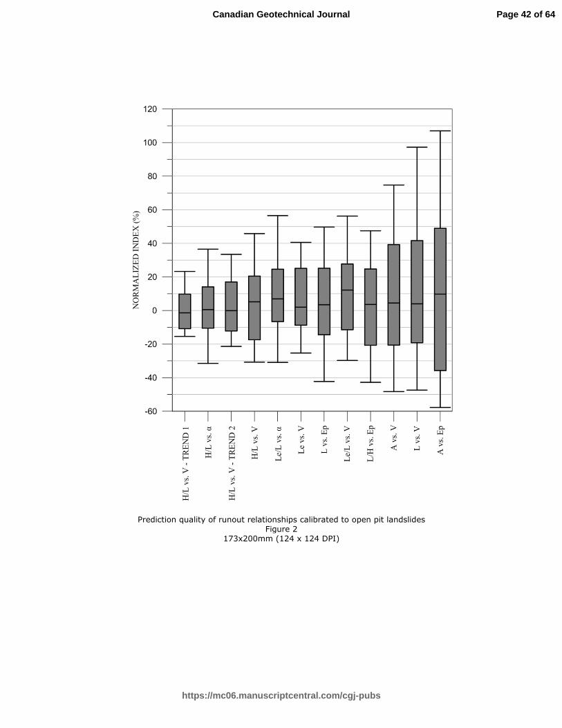
Draft
Prediction quality of runout relationships calibrated to open pit landslides Figure 2
173x200mm (124 x 124 DPI)
Page 42 of 64
https://mc06.manuscriptcentral.com/cgj-pubs
Canadian Geotechnical Journal

Draft
Open pit data with Scheidegger (1975), Li (1983), and Davidson (2011) best fit Fahrböschung angle vs. volume regressions
Figure 3 172x171mm (124 x 124 DPI)
Page 43 of 64
https://mc06.manuscriptcentral.com/cgj-pubs
Canadian Geotechnical Journal

Draft
Error distribution for Fahrböschung angle vs. volume mobility relationship Figure 4
153x137mm (124 x 124 DPI)
Page 44 of 64
https://mc06.manuscriptcentral.com/cgj-pubs
Canadian Geotechnical Journal
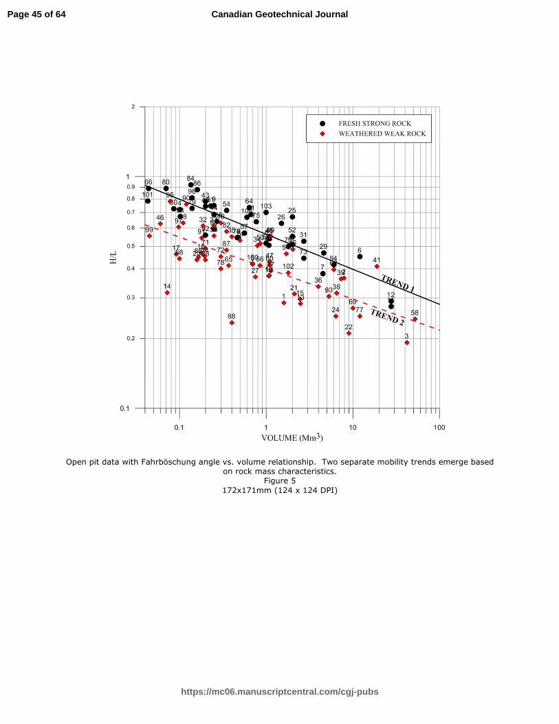
Draft
Open pit data with Fahrböschung angle vs. volume relationship. Two separate mobility trends emerge based
on rock mass characteristics.
Figure 5
172x171mm (124 x 124 DPI)
Page 45 of 64
https://mc06.manuscriptcentral.com/cgj-pubs
Canadian Geotechnical Journal

Draft
Error distribution for stratified Fahrböschung angle vs. volume mobility relationship Figure 6
153x135mm (124 x 124 DPI)
Page 46 of 64
https://mc06.manuscriptcentral.com/cgj-pubs
Canadian Geotechnical Journal
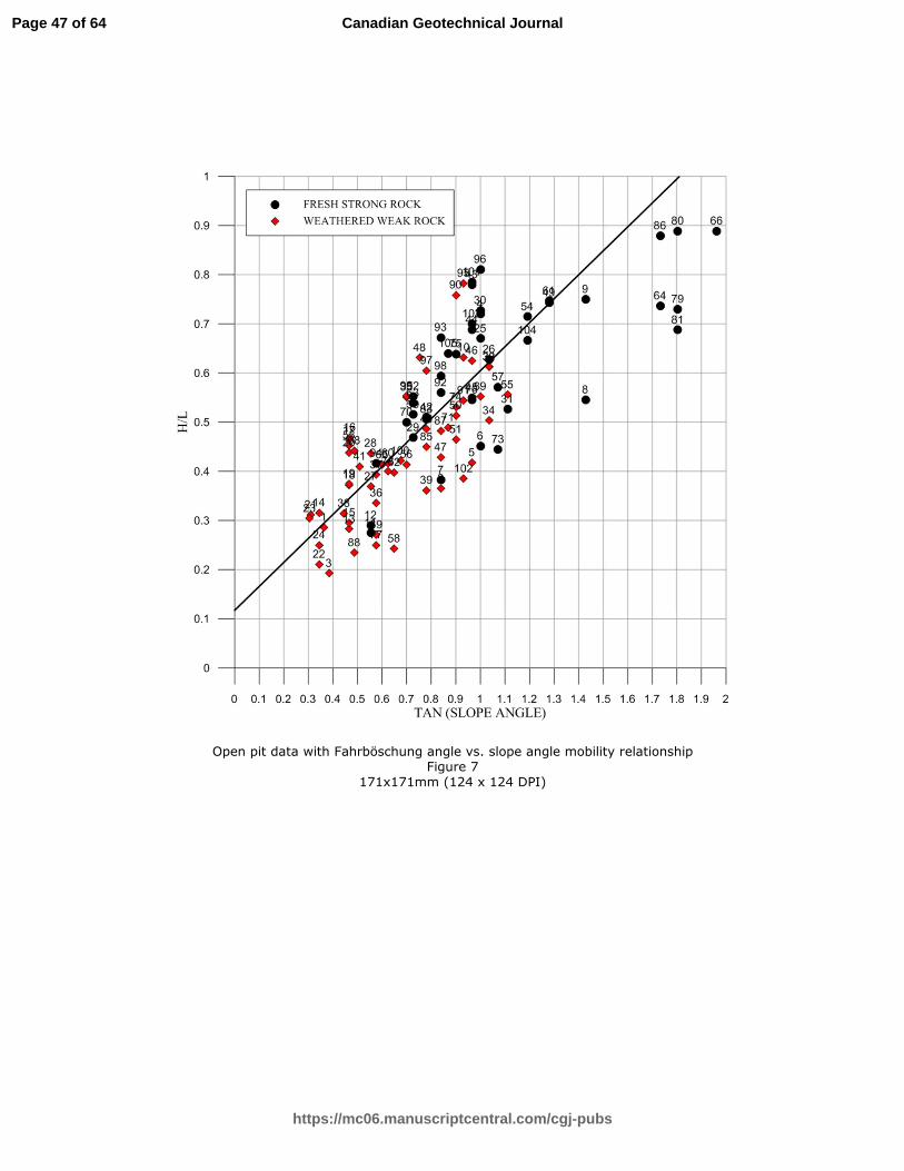
Draft
Open pit data with Fahrböschung angle vs. slope angle mobility relationship
Figure 7
171x171mm (124 x 124 DPI)
Page 47 of 64
https://mc06.manuscriptcentral.com/cgj-pubs
Canadian Geotechnical Journal

Draft
Error distribution for Fahrböschung angle vs. slope angle mobility relationship Figure 8
156x135mm (124 x 124 DPI)
Page 48 of 64
https://mc06.manuscriptcentral.com/cgj-pubs
Canadian Geotechnical Journal

Draft
Open pit data with inundation area vs. volume mobility relationship
Figure 9
171x166mm (124 x 124 DPI)
Page 49 of 64
https://mc06.manuscriptcentral.com/cgj-pubs
Canadian Geotechnical Journal

Draft
Error distribution for inundation area vs. volume mobility relationship Figure 10
158x139mm (124 x 124 DPI)
Page 50 of 64
https://mc06.manuscriptcentral.com/cgj-pubs
Canadian Geotechnical Journal

Draft
Fahrböschung angle vs. volume mobility relationship symbolized by slope angle
Figure 11
170x171mm (124 x 124 DPI)
Page 51 of 64
https://mc06.manuscriptcentral.com/cgj-pubs
Canadian Geotechnical Journal

Draft
Exaggerated schematic of slope angle’s effect on centripetal acceleration Figure 12
174x62mm (124 x 124 DPI)
Page 52 of 64
https://mc06.manuscriptcentral.com/cgj-pubs
Canadian Geotechnical Journal

Draft
Open pit data with Fahrböschung angle normalized to slope angle. Note there is no relationship with volume
when normalized to original slope angle.
Figure 13
175x170mm (124 x 124 DPI)
Page 53 of 64
https://mc06.manuscriptcentral.com/cgj-pubs
Canadian Geotechnical Journal

Draft
Open pit data with runout length vs. volume mobility relationship
Figure 14
174x174mm (124 x 124 DPI)
Page 54 of 64
https://mc06.manuscriptcentral.com/cgj-pubs
Canadian Geotechnical Journal

Draft
Distribution of error for runout length vs. volume mobility relationship Figure 15
158x135mm (124 x 124 DPI)
Page 55 of 64
https://mc06.manuscriptcentral.com/cgj-pubs
Canadian Geotechnical Journal

Draft
Comparison of open pit failure fall height to runout length Figure 16
174x174mm (124 x 124 DPI)
Page 56 of 64
https://mc06.manuscriptcentral.com/cgj-pubs
Canadian Geotechnical Journal

Draft
Map of deposit aspect observations Figure 17
167x170mm (96 x 96 DPI)
Page 57 of 64
https://mc06.manuscriptcentral.com/cgj-pubs
Canadian Geotechnical Journal

Draft
Degree of spreading in open pit slope failures Figure 18
201x199mm (124 x 124 DPI)
Page 58 of 64
https://mc06.manuscriptcentral.com/cgj-pubs
Canadian Geotechnical Journal

Draft
Open pit data with dimensionless mobility relationship
Figure 19
181x136mm (124 x 124 DPI)
Page 59 of 64
https://mc06.manuscriptcentral.com/cgj-pubs
Canadian Geotechnical Journal

Draft
Comparison of open pit failure and natural rock avalanche deposit spreads Figure 20
173x170mm (124 x 124 DPI)
Page 60 of 64
https://mc06.manuscriptcentral.com/cgj-pubs
Canadian Geotechnical Journal

Draft
Rock mass characteristics mobility trends matrix for use with Figure 5 Figure 21
101x95mm (144 x 144 DPI)
Page 61 of 64
https://mc06.manuscriptcentral.com/cgj-pubs
Canadian Geotechnical Journal

Draft
Open pit data compared to Corominas (1996) path obstruction Fahrböschung angle vs. volume mobility
relationship
Figure 22
170x171mm (124 x 124 DPI)
Page 62 of 64
https://mc06.manuscriptcentral.com/cgj-pubs
Canadian Geotechnical Journal

Draft
Fahrböschung angle vs. volume relationship symbolized by failure mechanism Figure 23
170x171mm (124 x 124 DPI)
Page 63 of 64
https://mc06.manuscriptcentral.com/cgj-pubs
Canadian Geotechnical Journal

Draft
�������������� ����������������������������������������������������������������������������������������������������������������������������������
��������� ��������!��������
������������
�������������������������� ����
��
�����
���
����
� � �
��� �����
�� ����� �
����� ��!�
����
��� "��
#������
$%&� $%&'()*+,#-().*/
� .(0�� ,)1� �� ���� ..�
$����.0,1��$%&���� ����.�� $%&'()220#-().2(
� */�� ()/� �� ���� ..�
Page 64 of 64
https://mc06.manuscriptcentral.com/cgj-pubs
Canadian Geotechnical Journal