Name : Broadway Plaza Location : Downtown Rochester, Minnesota Building Size : 29 Stories
FIVE-YEAR
PLAN UPDATE
MEDICAL INSTITUTIONAL CAMPUS
SPECIAL DISTRICT
ROCHESTER, MINNESOTA
MAYO SUPPORT CAMPUS
SPECIAL DISTRICT
NOVEMBER 2, 2016

November 2, 2016
TABLE OF CONTENTS
Introduction
1.0 Medical Institutional Campus Special District
Sub-District Definitions and Boundaries
Mayo Support Campus Special District
2.0 Mayo Property Ownership and Property Acreage
3.0 Building Square Footage
4.0 Mayo Employee Distribution
5.0 Campus Parking and Vehicular Circulation
6.0 Materials Handling and Distribution, Subways and Service Docks
7.0 Utility Infrastructure
8.0 Urban Green Space
9.0 Potential Projects:
Central Sub-District and West Sub-District
Mayo Support Campus Special District
Outside the Medical Institutional and Special Districts
10.0 Appendices
Glossary of Terms
City Plat Block Numbers
Building Address and Abbreviations
Central Development Core and Medical Campus Overlay Zones
Central Development Core Zoning District Regulations
Medical Institutional Campus Special District: Zoning Ordinances #2726 (1991), #3669 (2004), and
#4052 (2011)
Mayo Support Campus Special District: Zoning Ordinance #3534 (2003)

November 2, 2016
INTRODUCTION
This document is being submitted by Mayo Clinic in fulfillment of:
The provision in Chapter 64D of the Rochester, Minnesota, Code of Ordinances requiring Five-Year Plan
Updates for the Medical Institutional Campus Special District
Chapter 64N requiring Five-Year Plan
Updates for the Mayo Support Campus Special District.
These updated narratives and graphics demonstrate the continued support by Mayo Clinic for the concept of the
Special District land use and zoning controls. Mayo Clinic facilities and operations are organized around the concept
of integrated multi-campus wide operations and functional inter-relationships.
As an integral part of the downtown fabric, Mayo is engaged in planning efforts on many levels, including land use,
livability, economic development, higher education, and historic preservation. It is not the intention of this document
to duplicate, contradict, or supersede any previous or ongoing initiatives. Wherever possible, every effort has been
made to keep the Five-Year Plan Update ‘in step’ with the shared vision of Mayo’s neighbors and the City of
Rochester.
Planning initiatives considered in the preparation of the 2016 Five-Year Plan Update include:
Destination Medical Center Development Plan – April 2015
Downtown Rochester Master Plan Report – August 2010
Envision UMR (University of Minnesota Rochester) – A Campus Master Plan for the Next Chapter of Growth –
September 2014
Second Street Corridor Plan – February 2009
Rochester Historic inventory and Rochester Historical Contexts – July 2014
Mayo Clinic Rochester Campus: An Assessment of Cultural Resources – March 2015
Destination Medical Center District Design Guidelines – June 2016
*The data reported in the following chapters represents a snapshot in time. We acknowledge that these statistics are
subject to change, in some cases, on a weekly basis. The cutoff dates for each data set vary slightly, and are recorded
at the beginning of each chapter. Of particular note, the ‘41st Street Professional Office Building Campus’, located at Hwy 52 West Frontage Road NW and 41st Street NW, was purchased by The Mayo Clinic on September 1, 2016. Due
to the timing of data collection, the report totals do not reflect this acquisition. Square footages and acreages of this
campus are shown in footnotes to Chapters 2 and 3.

PART 1.0 | MEDICAL INSTITUTIONAL CAMPUS SPECIAL DISTRICT
SUB-DISTRICT DEFINITIONS AND BOUNDARIES
MAYO SUPPORT CAMPUS SPECIAL DISTRICT
November 2, 2016
1.0

PART 1.0 | MEDICAL INSTITUTIONAL CAMPUS SPECIAL DISTRICT
SUB-DISTRICT DEFINITIONS AND BOUNDARIES
MAYO SUPPORT CAMPUS SPECIAL DISTRICT
November 2, 2016
1.1
This Five-Year Plan Update addresses three distinct zones for accommodating Mayo Clinic Rochester functions:
1. Primary Medical Institutional
2. Transition
3. Non-Contiguous Support
The Medical Institutional Campus Special District was created in 1991 to assist and encourage the development of
medical institutional land uses in a campus setting at the Mayo Clinic Downtown and St. Marys Hospital Campuses.
Primary Medical Institutional and Transition areas are defined and mapped as part of the Special District, while Non-
Contiguous Support properties are not defined or mapped as part of the Special District, but are included here for
purposes of illustration in support of the concept of integrated campus-wide operations. Functions in the Mayo
Support Campus Special District are defined separately.
District Descriptions
The functional areas related to the Special District are defined as follows:
Primary Medical Institutional - The two areas, which correspond to the Mayo Clinic and Mayo Clinic Hospital
Methodist Campus (“Central Sub-District”) and Mayo Clinic Hospital Saint Marys Campus (“West Sub-
District”) campuses, create a Medical Institutional Campus Special District with two sub-districts, each with
their own zoning constraints.
These two areas include the core of Mayo Clinic institutional uses, in-patient and out-patient medical care, as
well as education and research functions and related medical support functions.
Transition - Transition areas are located at the periphery of both the Central and West Primary Medical
Institutional Sub-Districts. These are intended to provide a buffer, or physical transition, between large-scale
and/or active uses, and adjacent neighborhood residential uses.
Some Primary Medical Institutional uses may occur in transition areas, which will have more zoning
restrictions, although the emphasis in such areas will be medical-related extended-care, housing, and
support functions.
Non-Contiguous Support - To minimize congestion and other potential impacts, Mayo Clinic has
decentralized many support facilities to dispersed sites outside the Primary Medical Institutional areas where
possible. Buildings on these non-contiguous parcels are subject to underlying existing zoning code
provisions.
Uses on non-contiguous parcels may include parking, receiving and warehousing, waste management and
other support functions, such as administration and research support that can functionally be located on
dispersed sites. Primary care facilities are now located outside the primary and transition zones to relieve
congestion and provide convenience for patients in the Rochester community.

PART 1.0 | MEDICAL INSTITUTIONAL CAMPUS SPECIAL DISTRICT
SUB-DISTRICT DEFINITIONS AND BOUNDARIES
MAYO SUPPORT CAMPUS SPECIAL DISTRICT
November 2, 2016
1.2
The Mayo Support Campus Special District was created in 2003 to allow contiguous growth of certain decentralized
administrative and support functions, thereby relieving congestion in the Primary Medical Institutional District. The
Support Campus Special District boundaries are shown on page 1.8.
The functional area related to the Special District includes:
Administrative and Support Functions - Administrative and support functions not needing direct adjacency to
primary medical areas may be relocated to this campus. This strategy is intended to relieve the Primary
Medical District.
See page 1.4 for the relative location of all special districts.
Proposed Modifications and Additions to the Medical Institutional Campus Special District
While the City of Rochester has grown significantly in population (57,890 in 1985 to 112,000 est. in 2015) and area
through the past quarter-century, Mayo Clinic in Rochester has seen an even greater rate of growth. The Medical
Institutional Campus Special District proposed in 1985, and established in 1991, has effectively allowed both the City
and Mayo Clinic to plan infrastructure and facility investments to enable and accommodate this growth, while
achieving community goals for growth and vitality of the City and medical campuses. Mayo Clinic expects this growth
to continue, so that its cutting-edge global mission in patient care, education, and research continues to be realized.
In anticipation of projected growth over the next 25 years, district boundaries were modified in the 2011 Five-Year
Update and adopted into the City ordinances in 2012.
The Functional Emphasis Zones, depicted on page 1.3 (showing both the 2011 and updated 2016 plans), illustrate the
land use areas accommodating Mayo Campus functions. The Primary Medical Institutional Functional Emphasis zones
remain essentially unchanged. As compared with 2011, only Campus support has expanded beyond the Special
Districts.
Central Sub-district
The Central Sub-district was expanded westward in the 2011 Five-Year Update to include properties on both sides of
2nd Street SW, the former Lourdes High School building on West Center Street, and the blocks between 5th and 6th
Avenues NW extending north to Civic Center Drive. The current Central Sub-district boundaries are shown on page
1.5. The boundaries, as currently defined, are consistent with growth projections for the next Five-year period,
including the first phase of the DMC Discovery Square project. No further expansion of the Central Sub-district is
proposed at this time. The proposed Primary Medical Institutional Central Sub-district is illustrated on page 1.6.
West Sub-district
The West Sub-district was expanded eastward in the 2011 Five-Year Update to include properties on both sides of 2nd
Street SW including the Ronald McDonald House and The Gift of Life Transplant House and blocks south across 3rd
Street to include the Mayo Foundation House. No further expansion of the Wes Sub-district is proposed at this time.
The Primary Medical West Sub-district is illustrated on page 1.6.
Page 1.7 shows the relationship between these sub-districts and current zoning and property ownership.

400’ 1600’
800’
N
EXISTING FUNCTIONAL EMPHASIS ZONE
PROPOSED FUNCTIONAL EMPHASIS ZONE
1.3
NOVEMBER 2, 2016
MEDICAL INSTITUTIONAL COMMERCIAL SUPPORT GREEN SPACE

N mi. 2 mi.
1 mi.
1
2
4 mi.
MAYO CAMPUS OVERVIEW
1.4
NOVEMBER 2, 2016
MAYO SUPPORT
CAMPUS SPECIAL
DISTRICT
CENTRAL
SUBDISTRICT
WEST
SUBDISTRICT
MEDICAL INSTITUTIONAL
CAMPUS SPECIAL DISTRICT
PRIMARY MEDICAL INSTITUTIONAL SUBDISTRICTS
LARGE SCALE CAMPUS VIEWPORTS
MAYO SUPPORT CAMPUS SPECIAL DISTRICT

NOVEMBER 2, 2016
125’ 700’
350’
N
1.5
SUBDISTRICT EXISTING BOUNDARIES
5TH ST SW
6TH ST SW
7TH ST SW7TH ST SW
6TH ST SW
8TH ST SW
9TH ST SW
4TH ST SW
3RD ST SW
2ND ST SW
CENTER ST E
1ST ST NW
2ND ST NE
3RD ST NE3RD ST NW
2ND ST NW
1ST ST NE
CENTER ST E
1ST ST SE
2ND ST SE
4TH ST SE MN 296
4TH ST NE
5TH ST NW
8TH ST SW
7TH ST SW
5TH ST SW
4TH ST SW
3RD ST SW
2ND ST SW
1ST ST SW
W CENTER ST
1ST ST NW
2ND ST NW
3RD ST NW
4TH ST NW
2ND ST SW
1ST ST SW
W CENTER ST
1ST ST NW
2ND ST NW
4TH ST NW
4 1/2 ST SW
6TH ST SW
7TH ST SW
1ST
A
VE SW
2N
D A
VE SW
3R
D A
VE SW
4T
H A
VE SW
5T
H A
VE SW
6T
H A
VE SW
7T
H A
VE SW
8T
H A
VE SW
9T
H A
VE SW
10
TH
A
VE SW
6T
H A
VE SW
7T
H A
VE SW
9T
H A
VE SW
14
TH
A
VE SW
15
TH
A
VE SW
12
TH
AV
E SW
10TH ST SW
PLUM
MERS CIRCLE
6TH ST SW
15
TH
ST
SW
16
TH
ST
SW
13
TH
ST
N
W
12
TH
ST
N
W
11
TH
ST
N
W
16
TH
ST
N
W
16TH
AVE N
W
11
TH
A
VE N
W
7T
H A
VE N
W
6T
H A
VE N
W
5T
H A
VE N
W
4T
H A
VE N
W
3R
D A
VE N
W
1ST ST SW
1ST
A
VE N
W
BR
OA
DW
AY
1ST
A
VE N
E
2N
D A
VE N
E2
ND
A
VE SE
BR
OA
DW
AY
US 6
3
9T
H A
VE N
W
8 1/2
AVE
NW
8T
H A
VE N
W
CIVIC CENTER DRIVE
CIVIC CENTER DRIVECIVIC CENTER DRIVE
CIVIC CENTER DRIVE
CIVIC CENTER DRIVE
CIVIC CENTER DRIVE
TH
52
NB
& T
H 1
4 W
B
TH
52
SB
& T
H 1
4 E
B
TH
52 S
B &
TH
14 E
B
TH
52 N
B &
TH
14 W
B
TRANSITION ZONES PRIMARY MEDICAL INSTITUTIONAL SUBDISTRICTS
WEST CENTRAL

NOVEMBER 2, 2016
125’ 700’
350’
N
1.6
PROPOSED SUBDISTRICT BOUNDARIESCENTRAL AND WEST SUBDISTRICT MODIFICATION
5TH ST SW
6TH ST SW
7TH ST SW7TH ST SW
6TH ST SW
8TH ST SW
9TH ST SW
4TH ST SW
3RD ST SW
2ND ST SW
CENTER ST E
1ST ST NW
2ND ST NE
3RD ST NE3RD ST NW
1ST ST NE
CENTER ST E
1ST ST SE
2ND ST SE
4TH ST SE MN 296
4TH ST NE
5TH ST NW
8TH ST SW
7TH ST SW
5TH ST SW
4TH ST SW
2ND ST SW
1ST ST SW
W CENTER ST
1ST ST NW
2ND ST NW
3RD ST NW
4TH ST NW
2ND ST SW
1ST ST SW
W CENTER ST
1ST ST NW
2ND ST NW
4TH ST NW
4 1/2 ST SW
6TH ST SW
7TH ST SW
1ST
A
VE SW
2N
D A
VE SW
3R
D A
VE SW
4T
H A
VE SW
5T
H A
VE SW
6T
H A
VE SW
7T
H A
VE SW
8T
H A
VE SW
9T
H A
VE SW
10
TH
A
VE SW
6T
H A
VE SW
7T
H A
VE SW
9T
H A
VE SW
14
TH
A
VE SW
15
TH
A
VE SW
12
TH
AV
E SW
10TH ST SW
PLUM
MERS CIRCLE
6TH ST SW
15
TH
ST
SW
16
TH
ST
SW
13
TH
ST
N
W
12
TH
ST
N
W
11
TH
ST
N
W
16
TH
ST
N
W
16TH
AVE N
W
11
TH
A
VE N
W
7T
H A
VE N
W
6T
H A
VE N
W
5T
H A
VE N
W
4T
H A
VE N
W
3R
D A
VE N
W
1ST ST SW
1ST
A
VE N
W
BR
OA
DW
AY
1ST
A
VE N
E
2N
D A
VE N
E2
ND
A
VE SE
BR
OA
DW
AY
US 6
3
9T
H A
VE N
W
8 1/2
AVE
NW
8T
H A
VE N
W
CIVIC CENTER DRIVE
CIVIC CENTER DRIVECIVIC CENTER DRIVE
CIVIC CENTER DRIVE
CIVIC CENTER DRIVE
CIVIC CENTER DRIVE
TH
52
NB
& T
H 1
4 W
B
TH
52
SB
& T
H 1
4 E
B
TH
52 S
B &
TH
14 E
B
TH
52 N
B &
TH
14 W
B
2N
D ST
N
W
CONVENT
3RD ST SW
2ND ST NW
TRANSITION ZONES PRIMARY MEDICAL INSTITUTIONAL SUBDISTRICTS MODIFIED MAYO PROPERTY TRANSITION ZONE WITH MAYO PROPERTY MODIFIED TRANSITION ZONE / MAYO PROPERTY
WEST CENTRAL

NOVEMBER 2, 2016
125’ 700’
350’
N
1.7
SUBDISTRICT BOUNDARIES WITH CURRENT ZONING & PROPERTY OWNERSHIP
CDC-MED
CDC-RES
CDC-FR
CDC-MED
CDC-RES
CDC-FR
CDC-RES
CDC-CBD
CDC-FR
R2
PUD
R4
R4
R1
R4
CDC-FR
R4
PUD
CDC DISTRICTS AND MEDICAL CAMPUS
OVERLAY ZONES
CDC-CBD
CDC-FR
CDC-MED
CDC-RES
PUD
R1,R2,R4
CENTRAL BUSINESS DISTRICT
FRINGE
MEDICAL
RESIDENTIAL
PLANNED UNIT DEVELOPMENT
RESIDENTIAL
PRIMARY MEDICAL INSTITUTE SUBDIST.
MEDICAL TRANSITION SUBDISTRICT
MAYO OWNED PROPERTY
MAYO OWNED BUILDING
* FOR DEFINITIONS SEE APPENDIX
WEST CENTRAL

400’ 1600’
800’
N
SUBDISTRICT BOUNDARIES
1.8
NOVEMBER 2, 2016
LEASED CAMPUS OUTSIDE OF DISTRICT
SUPPORT CAMPUS SPECIAL DISTRICT
MAYO PROPERTY IN THE SPECIAL DISTRICT MAYO PROPERTY
NORTHWEST

PART 2.0 | MAYO PROPERTY OWNERSHIP AND PROPERTY ACREAGE
November 2, 2016
2.0

PART 2.0 | MAYO PROPERTY OWNERSHIP AND PROPERTY ACREAGE
November 2, 2016
2.1
The tables and graphics on the following pages illustrate current property ownership by Mayo Clinic within and
adjacent to the Primary Medical Institutional Sub-Districts, within the Mayo Support Campus Special District as well as
properties outside the Districts. All data is current as of March 31, 2016, unless otherwise noted, and is summarized
on this page.
*Note: The 41st Street Professional Buildings were purchased after the cut-off date. The acquired total of 19.64 acres
is not included in the data for this chapter.
SPECIAL DISTRICT AREA
Primary Medical Institutional Districts
1/1/2016
Central Sub-District 55.03 acres
West Sub-District 57.30 acres
112.33 Acres
Mayo Support Campus Special District
1/1/2016
Mayo Support Center 43.20 acres
43.20 Acres
Non-Contiguous Support Area
Mayo Clinic-owned property outside of the Sub-Districts but within Rochester city limits.
1/1/2016
Out of District 350.55 acres
350.55 Acres
The boundaries as shown are approximate and are intended for illustrative purposes only. They are intended to
delineate the amount of Mayo-owned property within the scope of this mapping project.
SUMMARY OF TOTALS
Total Area (Acres)
LOT 2016
Central Sub-District Area Total 55.03
West Sub-District Area Total 57.30
Mayo Special Sub-District Area Total 43.20
Outside District Area Total 350.55
MAYO ROCHESTER ACREAGE TOTAL 506.08 *
* In 2015 and 2016 a detailed inventory of Mayo Buildings and Property Area was completed utilizing Olmsted County GIS data. The
2016 areas above reflect these calculations and are more accurate than what was recorded in the 2011 Five-Year Plan Update.

PART 2.0 | MAYO PROPERTY OWNERSHIP AND PROPERTY ACREAGE
November 2, 2016
2.2
Property Area Summary (as of 03/31/2016)
CENTRAL SUB-DISTRICT (Downtown Campus)
Total Area (Acres)
LOT 2016
Baldwin Building/Parking Ramp/Traveler’s Hotel 2.63
Charlton/Eisenberg/Charlton North/Colonial 6.23
Charter House 1.76
Dan Abraham Healthy Living Center 1.36
Damon Patient-Visitor Parking Ramp/Statuary Park 1.36
Employee East Parking Ramp 0.79
Employee West Parking Ramp 1.79
Franklin Station/Parking Lot 19 0.79
Graham Parking Ramp 0.86
Graham Building and Parking Lot 1 1.06
Guggenheim/Hilton/Mitchell Student Center Buildings 2.21
Gonda/Mayo Buildings/Annenberg Plaza 4.09
Harwick/Medical Science Buildings/Parking Lot 5 (including vacated street) 2.37
Hope Lodge 1.69
Jacobson Building 2.26
Johnson Building/Prospect Utility Plant/Parking Lot 20 1.64
Former Lourdes Building 1.81
Opus Building/Parking Lots 3 and 3A 2.66
Ozmun Parking Ramp/Ozmun East/Center/West Buildings 4.11
Plummer/Siebens Buildings (including vacated street) 1.03
109 Building/Parking Lot 22 0.54
Parking Lot 6 2.27
Parking Lot 2 / 428 Building 2.13
Parking Lot 10 0.52
Parking Lot 11 1.13
Parking Lot 15 and North Outlot 1.01
Parking Lot 28 0.30
(Continued on next page)

PART 2.0 | MAYO PROPERTY OWNERSHIP AND PROPERTY ACREAGE
November 2, 2016
2.3
Property Area Summary (as of 03/31/2016)
CENTRAL SUB-DISTRICT (Downtown Campus)
Total Area (Acres)
LOT 2016
Parking Lot 26 0.49
Parking Lot 29 1.81
Parking Lot 30 1.69
5th Avenue Inn and Parking Lot 0.64
CENTRAL SUBTOTAL 55.03
WEST SUB-DISTRICT
Total Area (Acres)
LOT 2016
Gift of Life Transplant House (North) 1.09
Gift of Life Transplant House (South) 1.35
2nd Street Inn and Suites / Parking Lot 31 1.95
Ronald McDonald House 0.57
Mayo Hospital Saint Marys Campus 49.63
Foundation House / Walters Houses / Damon House 2.71
WEST SUBTOTAL 57.30
MAYO SUPPORT CAMPUS SPECIAL DISTRICT (Northwest Campus)
Total Area (Acres)
LOT 2016
Mayo Support Center 43.20
MSC SUBTOTAL 43.20
MAYO SPECIAL DISTRICT ACREAGE TOTAL 155.53
* In 2015 and 2016 a detailed inventory of Mayo Buildings and Property Area was completed. The 2016 areas above reflect these
calculations and are more accurate than what was recorded in the 2011 Five-Year Plan Update.

PART 2.0 | MAYO PROPERTY OWNERSHIP AND PROPERTY ACREAGE
November 2, 2016
2.4
Property Area Summary (as of 03/31/2016)
OUTSIDE DISTRICT (Mayo-Owned)
Total Area (Acres)
LOT 2016
Archive Warehouse 1.12
Development Project Support Facility 3.24
East Shuttle Lot 35/South Warehouse 9.82
Facilities Warehouse 7.86
Gold Cross North 0.85
Incinerator/Gold Cross South 28.10
Institute Hills Farm 187.16
Lots West of SMC on 14th Avenue 0.96
Mayo Employees Federal Credit Union – Cascade Lake 2.44
Mayo Employees Federal Credit Union – 41st Street 1.48
Mayo Family Clinic NE 9.73
Mayowood 11.16
Mayo Inventory Center 8.53
North Warehouse 2.85
Parking Lot 16 (Foundation House West) 0.19
Parking Lot 17 (Foundation House East) 0.36
Parking Lot 32 0.99
Parking Lot 33 3.03
Franklin Warehouse 0.83
Rosa Parks Pavilion 0.26
Stabile Building 0.46
Superior Drive Support Center 26.17
201 Building 0.45
Technology Drive Center 4.26
Technology Drive Warehouse 3.27
West Employee Lot 36 14.11
Warehouse 2915 7.63
Corner of Frontage Road CSAH 22 & Woodland Drive 6.13
(Continued on next page)

PART 2.0 | MAYO PROPERTY OWNERSHIP AND PROPERTY ACREAGE
November 2, 2016
2.5
Property Area Summary (as of 03/31/2016)
OUTSIDE DISTRICT (Mayo-Owned)
Total Area (Acres)
LOT 2016
Adjacent to the North of Parcel 641032061833 0.66
ROW along CSAH 1 - Meadow Park South 6.33
MAYO-OWNED OUTSIDE SUBTOTAL 350.55
OUTSIDE DISTRICT ACREAGE TOTAL 350.55
* In 2015 and 2016 a detailed inventory of Mayo Buildings and Property Area was completed. The 2016 areas above reflect these
calculations and are more accurate than what was recorded in the 2011 Five-Year Plan Update.

NOVEMBER 2, 2016
125’ 700’
350’
N
2.6
PROPERTY OWNERSHIP
5TH ST SW
6TH ST SW
7TH ST SW7TH ST SW
6TH ST SW
8TH ST SW
9TH ST SW
4TH ST SW
3RD ST SW
2ND ST SW
CENTER ST E
1ST ST NW
2ND ST NE
3RD ST NE3RD ST NW
2ND ST NW
1ST ST NE
CENTER ST E
1ST ST SE
2ND ST SE
4TH ST SE MN 296
4TH ST NE
5TH ST NW
8TH ST SW
7TH ST SW
5TH ST SW
4TH ST SW
3RD ST SW
2ND ST SW
1ST ST SW
W CENTER ST
1ST ST NW
2ND ST NW
3RD ST NW
4TH ST NW
2ND ST SW
1ST ST SW
W CENTER ST
1ST ST NW
2ND ST NW
4TH ST NW
4 1/2 ST SW
6TH ST SW
7TH ST SW
1ST
A
VE SW
2N
D A
VE SW
3R
D A
VE SW
4T
H A
VE SW
5T
H A
VE SW
6T
H A
VE SW
7T
H A
VE SW
8T
H A
VE SW
9T
H A
VE SW
10
TH
A
VE SW
6T
H A
VE SW
7T
H A
VE SW
9T
H A
VE SW
14
TH
A
VE SW
15
TH
A
VE SW
12
TH
AV
E SW
10TH ST SW
PLUM
MERS CIRCLE
6TH ST SW
15
TH
ST
SW
16
TH
ST
SW
13
TH
ST
N
W
12
TH
ST
N
W
11
TH
ST
N
W
16
TH
ST
N
W
16TH
AVE N
W
11
TH
A
VE N
W
7T
H A
VE N
W
6T
H A
VE N
W
5T
H A
VE N
W
4T
H A
VE N
W
3R
D A
VE N
W
1ST ST SW
1ST
A
VE N
W
BR
OA
DW
AY
1ST
A
VE N
E
2N
D A
VE N
E2
ND
A
VE SE
BR
OA
DW
AY
US 6
3
9T
H A
VE N
W
8 1/2
AVE
NW
8T
H A
VE N
W
CIVIC CENTER DRIVE
CIVIC CENTER DRIVECIVIC CENTER DRIVE
CIVIC CENTER DRIVE
CIVIC CENTER DRIVE
CIVIC CENTER DRIVE
TH
52
NB
& T
H 1
4 W
B
TH
52
SB
& T
H 1
4 E
B
TH
52 S
B &
TH
14 E
B
TH
52 N
B &
TH
14 W
B
2N
D ST
N
W
CONVENT
MAYO PROPERTY MAYO BUILDING NON-MAYO BUILDING
WEST CENTRAL

400’ 1600’
800’
N
PROPERTY OWNERSHIP
2.7
NOVEMBER 2, 2016
MAYO PROPERTY MAYO BUILDING NON-MAYO BUILDING
NORTHWEST

N mi. 2 mi.
1 mi.
1
2
4 mi. 2.8
PROPERTY OWNERSHIP
NOVEMBER 2, 2016
MAYO
SUPPORT
CENTER
CORNER OF FRONTAGE ROAD
CSAH 22 AND WOODLAND DRIVE
WEST EMPLOYEE
SHUTTLE LOT
INSTITUTE
HILLS FARM
FRANKLIN
MAINTENANCE
FACILITY
INCINERATOR &
GOLD CROSS SOUTH
MAYO EMPLOYEE
FEDERAL CREDIT
UNION CASCADE
LAKE
MAYOWOOD
NON-CONTIGUOUS MAYO PROPERTY
MAYO SUPPORT CAMPUS SPECIAL DISTRICT
PRIMARY MEDICAL INSTITUTIONAL SUBDISTRICTS
LARGE SCALE CAMPUS VIEWPORTS

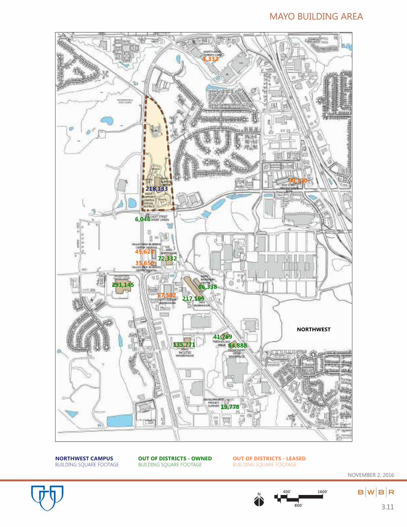
PART 3.0 | BUILDING SQUARE FOOTAGE
November 2, 2016
3.0

PART 3.0 | BUILDING SQUARE FOOTAGE
November 2, 2016
3.1
The tables and graphics on the following pages summarize Mayo Clinic-occupied building square footage within and
adjacent to the Central and West Sub-Districts, as well as the Mayo Support Campus Special District. All data is
current as of March 31, 2016.
*Note: The 41st Street Professional Buildings were purchased after the cut-off date. The acquired total of 450,000
square feet is not included in the data for this chapter.
In 2015 and 2016, a detailed inventory of Mayo Buildings and Property Area was completed. The 2016 areas reflect
these calculations and are more accurate than what was recorded in the 2011 Five-Year Plan Update.
The narrative and drawings show total building area distributed in each Special District and Sub-District. Area for
Support Functions such as utility plants, parking and ancillary space within Sub-Districts, warehouses outside the Sub-
District, and leased space for support in the Central Development Core are listed separately.
Floor Area – Owned Buildings
Floor areas in owned buildings are calculated as follows:
Sum of the gross horizontal area of the floors of a building measured from the outside faces of walls.
Floor area is inclusive of mechanical and sub ground levels.
In floors having openings for multi-level atriums, atrium space is not included.
Floor levels having occupied space adjacent to or below a court yard and/or street are included (example –
under Annenberg Plaza and/or Peace Plaza).
Subways/utility tunnels between buildings are not included.
Mezzanine levels are the gross of occupied area of floor inclusive of shafts and elevators.
Not including interior parking spaces, loading space for motor vehicles, or any space where the floor-to-
ceiling height is less than six (6) feet.
Floor Area – Leased Space
Floor areas in leased buildings are calculated as follows:
Partial floor – outside face of walls surrounding and contiguous with leased space.
Full floor – use Mayo floor area for owned buildings (above).

PART 3.0 | BUILDING SQUARE FOOTAGE
November 2, 2016
3.2
FLOOR AREA RATIO
Central Sub-District (Downtown Campus)
Maximum Floor Area Ratio (F.A.R.) allowable – 6.0
1/1/2016
Total Area in Structures 9,745,130 SF
Total Parking Structure Area -___2,346,304 SF
Total Building Area 7,398,826 SF
Total Land Area ÷__2,397,107 SF
Actual F.A.R. 3.09
West Sub-District (Saint Marys Campus)
Maximum Floor Area Ratio (F.A.R.) allowable – 4.0
1/1/2016
Total Area in Structures 4,005,739 SF
Total Parking Ramp Area -____949,026 SF
Total Building Area 3,056,713 SF
Total Land Area ÷__2,495,988 SF
Actual F.A.R. 1.22
Mayo Support Campus Special District
Maximum Floor Area Ratio (F.A.R.) allowable – 0.5
1/1/2016
Total Area in Structures 218,133 SF
Total Parking Ramp Area -___________0 SF
Total Building Area 218,133 SF
Total Land Area ÷_ 1,881,620 SF
Actual F.A.R. 0.11

PART 3.0 | BUILDING SQUARE FOOTAGE
November 2, 2016
3.3
Building Square Footage Summary (as of 03/31/2016)
CENTRAL SUB-DISTRICT (Downtown Campus)
OWNED
(Non-Parking)
Total Gross Square Feet
CODE BUILDING 2016
BA Baldwin Building 221,179
CH Charlton Building 301,299
CN Charlton North 69,821
CO Colonial Building 65,790
CR Charter House 512,151
DA Dan Abraham Healthy Living Center 226,693
EI Eisenberg Building 813,472
FK Franklin Heating Station 97,786
GN Generator Building 0
GO Gonda Building 1,567,591
GR Graham Building 18,439
GU Guggenheim Building 543,234
HA Harwick Building 177,153
HI Hilton Building 405,137
JB Jacobson Building 264,617
JP Johnson Building 15,210
MA Mayo Building 1,090,178
MI Mitchel Student Center 25,472
MR Connolly Building 9,683
MS Medical Sciences Building 161,639
OC OE OW Ozmun Buildings (Center, East and West) 236,462
ON 109 Building 1,578
OP Opus Building 39,462
PL Plummer Building 259,456
PR Prospect Utility Plant 33,414
SI Siebens Building (including Marriott Subway) 233,829
VN 428 Building 8,081
CENTRAL SUB-DISTRICT SUBTOTAL 7,398,826

PART 3.0 | BUILDING SQUARE FOOTAGE
November 2, 2016
3.4
WEST SUB-DISTRICT (Saint Marys Campus)
OWNED
(Non-Parking)
Total Gross Square Feet
CODE BUILDING 2016
AL Alfred Building 208,612
CL Chapel 30,226
CT Convent 40,376
DO Domitilla Building 302,206
FR Francis Building 330,177
GE Generose Building 283,496
JO Joseph Building 283,502
LY Laundry Building 49,519
MB Mary Brigh Building 1,329,207
MH OL Marian Hall and Old Marian Hall 102,564
PP Power Plant 88,312
SG Service Building 8,516
WEST SUB-DISTRICT SUBTOTAL 3,056,713
MAYO SUPPORT CAMPUS SPECIAL DISTRICT (Northwest Campus)
OWNED
(Non-Parking)
Total Gross Square Feet
CODE BUILDING 2016
SN SS Mayo Support Center (North and South) 218,133
MAYO SUPPORT CENTER SUB-DISTRICT TOTAL 218,133
MAYO SPECIAL DISTRICT SQUARE FOOTAGE TOTAL 10,673,672

PART 3.0 | BUILDING SQUARE FOOTAGE
November 2, 2016
3.5
OUTSIDE OF DISTRICTS
OWNED
(Non-Parking)
Total Gross Square Feet
CODE BUILDING 2016
AW Archive Warehouse 33,751
CP Mayo Employees Federal Credit Union – Canal Place 7,075
CU Mayo Employees Federal Credit Union – Cascade Lake 34,842
DH Damon House 9,507
DP Development Project Support Facility 19,778
FH FA Foundation House | Foundation House Apartment 26,516
F1 Franklin Warehouse 4,408
FW Facilities Warehouse 135,771
GC Gold Cross North 17,009
GD Gold Cross South 6,142
IC Mayo Inventory Center 86,338
IH Institute Hills Administration Building 61,230
IN Incinerator 42,686
ME Mayo Employee Federal Credit Union - 41st Street 6,046
NE Mayo Family Clinic Northeast 51,631
NO North Warehouse 151,753
PB Rosa Parks Pavilion 106,694
ST Stabile Building 272,583
SU Superior Drive Support Center 291,145
SW South Warehouse 48,338
TD Technology Drive Center 41,769
TH 3939 Warehouse 72,332
TN Warehouse 2915 217,199
TO 201 Building 69,711
TW Technology Drive Warehouse 84,888
WH Walters House 6,392
MAYO-OWNED OUTSIDE OF DISTRICT SUBTOTAL 1,905,534

PART 3.0 | BUILDING SQUARE FOOTAGE
November 2, 2016
3.6
ALL LOCATIONS
NON-OWNED (Leased)
(Non-Parking)
Total Gross Square Feet
CODE BUILDING 2016
AB Associated Bank 0 *
AH Assisi Heights 240
BB Minnesota Bio-Business Center 55,619
BK Brackenridge Building 33,887
BL Blakely Building 6,236
CB City Centre 4,570
CE Centerplace 80,095
FF 41st Street Professional Building (NW Clinic) 99,120
HO 7th Street Business Center (50) 2,877
KA Kahler Grand Hotel 6,177
KE Kersten Building 2,981
KP Rochester Marriot Hotel 470
LC Lanmark Center Building 38,803
MY Massey Building 23,970
N2 40th Avenue Warehouse 57,502
NB North Broadway Building 10,592
NX Mayo Clinic Express Care North 1,332
OG 1937 Building 16,434
SC 7th Street Business Center (112) 9,843
SE Mayo Family Clinic Southeast 22,013
SU Superior Drive Support Center 0 *
SX Mayo Clinic Express Care South 890
TT 3033 41st Street Building 99,120
V2 Valley High Business Center North 45,628
VH Valley High Business Center South 35,650
WF Wells Fargo Center 43,512
(Continued on next page)
* Properties no longer leased by Mayo

PART 3.0 | BUILDING SQUARE FOOTAGE
November 2, 2016
3.7
ALL LOCATIONS
NON-OWNED (Leased)
(Non-Parking)
(Continued)
Total Gross Square Feet
CODE BUILDING 2016
WT Warehouse 2535 0
NON-OWNED LEASED SUBTOTAL 598,441
OUTSIDE DISTRICT SQUARE FOOTAGE TOTAL 2,503,975

PART 3.0 | BUILDING SQUARE FOOTAGE
November 2, 2016
3.8
PARKING STRUCTURES
OWNED CENTRAL SUB-DISTRICT (Downtown Campus)
OWNED
(Parking)
Total Gross Square Feet
CODE BUILDING 2016
BR Baldwin Parking Ramp 8 227,300
CR Charter House Parking Ramp 63,564
DR Damon Parking Ramp 316,797
FS Employee First Street Ramp 12 256,558
GP Graham Parking Ramp 351,040
OR Ozmun Parking Ramp 21 (w/Dock & Link) 190,505
RE Employee East Parking Ramp 248,366
RW Employee West Parking Ramp 692,174
CENTRAL SUBTOTAL 2,346,304
WEST SUB-DISTRICT (Saint Marys Campus)
OWNED
(Parking)
Total Gross Square Feet
CODE BUILDING 2016
ER SMC East Employee Ramp – Parking Lot 34 379,455
VR Mary Brigh Parking Ramp 179,230
WR Generose Parking Ramp 390,341
WEST SUBTOTAL 949,026
MAYO SPECIAL DISTRICT SQUARE FOOTAGE TOTAL (PARKING) 3,295,330

PART 3.0 | BUILDING SQUARE FOOTAGE
November 2, 2016
3.9
NON-OWNED (Leased)
(Parking)
Total Gross Square Feet
CODE BUILDING 2016
TR Third Street Ramp 191,342
NON-OWNED LEASED SUBTOTAL 191,342
PARKING STRUCTURE SQUARE FOOTAGE TOTAL 3,486,672
SUMMARY TOTAL
Total Gross Square Feet
DISTRICT TOTAL 2016
Central Sub-District Area Total 9,745,130
West Sub-District Area Total 4,005,739
Mayo Support Center Sub-District Area Total 218,133
Outside District Area Total 2,503,975
MAYO ROCHESTER SQUARE FOOTAGE TOTAL 16,472,977

NOVEMBER 2, 2016
125’ 700’
350’
N
3.10
MAYO BUILDING AREA
208,612
30,226
LAUNDRY
CONVENT40,37649,519
302,206330,177
283,496
283,496
1,329,207
102,564
88,312
8,516
379,455
179,230
390,341
9,507
26,516
6,392
221,179
69,821
65,790
512,151
226,693
813,472
1,567,591
18,439
543,234
177,153405,137
264,617
15,210
1,090,178
25,472
9,683 161,639
236,462
1,578
39,462
259,456
33,414
233,829
8,081
106,694
272,583
69,711
55,619
33,887
6,236
4,570
80,095
6,177
2,981
470
38,803
23,970
43,512
227,300
63,564
316,797
256,558 351,040
190,505
248,366
692,174
191,342
33,751 17,009 151,753
48,338
49,137
5TH ST SW
6TH ST SW
7TH ST SW7TH ST SW
6TH ST SW
8TH ST SW
9TH ST SW
4TH ST SW
3RD ST SW
2ND ST SW
CENTER ST E
1ST ST NW
2ND ST NE
3RD ST NE3RD ST NW
2ND ST NW
1ST ST NE
CENTER ST E
1ST ST SE
2ND ST SE
4TH ST SE MN 296
4TH ST NE
5TH ST NW
8TH ST SW
7TH ST SW
5TH ST SW
4TH ST SW
3RD ST SW
2ND ST SW
1ST ST SW
W CENTER ST
1ST ST NW
2ND ST NW
3RD ST NW
4TH ST NW
2ND ST SW
1ST ST SW
W CENTER ST
1ST ST NW
2ND ST NW
4TH ST NW
4 1/2 ST SW
6TH ST SW
7TH ST SW
1ST
A
VE SW
2N
D A
VE SW
3R
D A
VE SW
4T
H A
VE SW
5T
H A
VE SW
6T
H A
VE SW
7T
H A
VE SW
8T
H A
VE SW
9T
H A
VE SW
10
TH
A
VE SW
6T
H A
VE SW
7T
H A
VE SW
9T
H A
VE SW
14
TH
A
VE SW
15
TH
A
VE SW
12
TH
AV
E SW
10TH ST SW
PLUM
MERS CIRCLE
6TH ST SW
15
TH
ST
SW
16
TH
ST
SW
13
TH
ST
N
W
12
TH
ST
N
W
11
TH
ST
N
W
16
TH
ST
N
W
16TH
AVE N
W
11
TH
A
VE N
W
7T
H A
VE N
W
6T
H A
VE N
W
5T
H A
VE N
W
4T
H A
VE N
W
3R
D A
VE N
W
1ST ST SW
1ST
A
VE N
W
BR
OA
DW
AY
1ST
A
VE N
E
2N
D A
VE N
E2
ND
A
VE SE
BR
OA
DW
AY
US 6
3
9T
H A
VE N
W
8 1/2
AVE
NW
8T
H A
VE N
W
CIVIC CENTER DRIVE
CIVIC CENTER DRIVECIVIC CENTER DRIVE
CIVIC CENTER DRIVE
CIVIC CENTER DRIVE
CIVIC CENTER DRIVE
TH
52
NB
& T
H 1
4 W
B
TH
52
SB
& T
H 1
4 E
B
TH
52 S
B &
TH
14 E
B
TH
52 N
B &
TH
14 W
B
2N
D A
VE N
W
301,299
SAINT MARY’S CAMPUS
BUILDING SQUARE FOOTAGE
DOWNTOWN CAMPUS
BUILDING SQUARE FOOTAGE
OUT OF DISTRICTS - OWNED
BUILDING SQUARE FOOTAGE
OUT OF DISTRICTS - LEASED
BUILDING SQUARE FOOTAGE
WEST CENTRAL
400’ 1600’
800’
N
MAYO BUILDING AREA
3.11
NOVEMBER 2, 2016
291,145
72,332
41,769
86,338
135,771
218,133
84,888
6,046
99,120
217,199
19,778
1,332
45,628
35,650
57,502
NORTHWEST CAMPUS
BUILDING SQUARE FOOTAGE
OUT OF DISTRICTS - OWNED
BUILDING SQUARE FOOTAGE
OUT OF DISTRICTS - LEASED
BUILDING SQUARE FOOTAGE
NORTHWEST

N mi. 2 mi.
1 mi.
1
2
4 mi.
MAYO BUILDING AREA
3.12
NOVEMBER 2, 2016
MAYO FAMILY CLINIC SOUTHEAST
SOUTH MAYO EXPRESS CARE
7TH STREET PROFESSIONAL BLDGSWAREHOUSE 25351937 BUILDING
ASSISSI HEIGHTS
NORTH BROADWAY BUILDING
INSTITUTE
HILLS FARM
10,592
240
016,434
12,720
890
61,230
22,013
MAYO EMPLOYEE FEDERAL
CREDIT UNION CASCADE LAKE
34,842
MAYO FAMILY CLINIC NE51,631
INCINERATOR
42,686
MAYO EMPLOYEE FEDERAL
CREDIT UNION CANAL PLACE7,075
PRIMARY MEDICAL INSTITUTIONAL SUBDISTRICTS
LARGE SCALE CAMPUS VIEWPORTS
MAYO SUPPORT CAMPUS SPECIAL DISTRICT

PART 4.0 | MAYO EMPLOYEE DISTRIBUTION
November 2, 2016
4.0
PART 4.0 | MAYO EMPLOYEE DISTRIBUTION
November 2, 2016
4.1
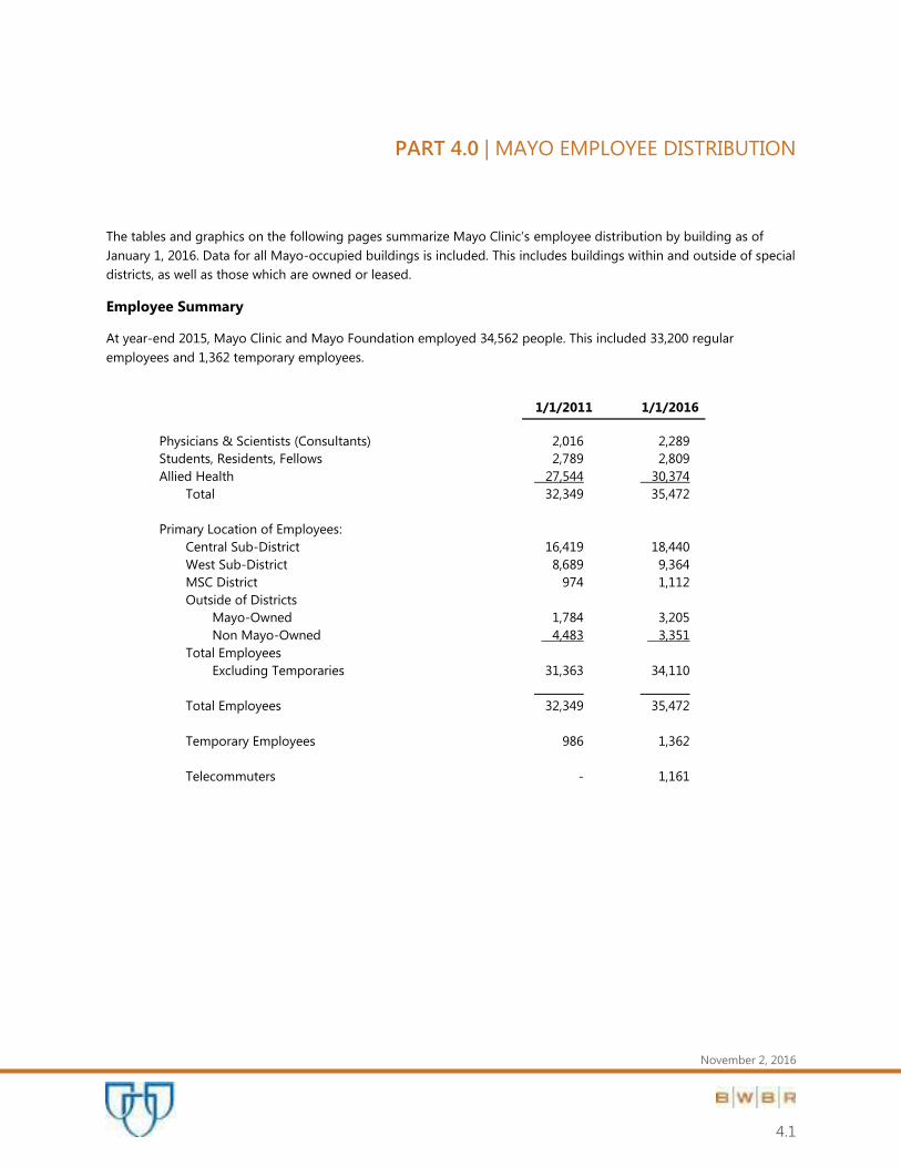
The tables and graphics on the following pages summarize Mayo Clinic’s employee distribution by building as of
January 1, 2016. Data for all Mayo-occupied buildings is included. This includes buildings within and outside of special
districts, as well as those which are owned or leased.
Employee Summary
At year-end 2015, Mayo Clinic and Mayo Foundation employed 34,562 people. This included 33,200 regular
employees and 1,362 temporary employees.
1/1/2011 1/1/2016
Physicians & Scientists (Consultants) 2,016 2,289
Students, Residents, Fellows 2,789 2,809
Allied Health 27,544 30,374
Total 32,349 35,472
Primary Location of Employees:
Central Sub-District 16,419 18,440
West Sub-District 8,689 9,364
MSC District 974 1,112
Outside of Districts
Mayo-Owned 1,784 3,205
Non Mayo-Owned 4,483 3,351
Total Employees
Excluding Temporaries 31,363 34,110
_________ _________
Total Employees 32,349 35,472
Temporary Employees 986 1,362
Telecommuters - 1,161

PART 4.0 | MAYO EMPLOYEE DISTRIBUTION
November 2, 2016
4.2
CENTRAL SUB-DISTRICT (Downtown Campus)
Employees
CODE BUILDING 2011 2016
BA Baldwin Building 696 712
CH Charlton Building 1,012 1,038
CN Charlton North 88 146
CO Colonial Building 68 84
CR Charter House 366 303
DA Dan Abraham Healthy Living Center 76 156
DR Damon Parking Ramp 14 22
EI Eisenberg Building 2,258 2,479
FK Franklin Heating Station 45 42
GO Gonda Building 2,877 3,392
GP Graham Parking Ramp 0 0
GR Graham Building 67 80
GU Guggenheim Building 845 914
HA Harwick Building 379 645
HI Hilton Building 1,840 1,837
JB Jacobson Building - 73
JP Johnson Building 2 2
MA Mayo Building 3,196 3,391
MI Mitchel Student Center 47 234
MR Connolly Building 20 19
MS Medical Sciences Building 205 230
OC OE OW Ozmun Buildings (Center, East and West) 1,030 1,098
OP Opus Building 52 58
PL Plummer Building 672 683
PR Prospect Utility Plant 4 0
RE East Employee Parking Ramp 0 0
RW West Employee Parking Ramp 0 0
SI Siebens Building (including Marriott Subway) 560 791
VN 428 Building 0 11
CENTRAL SUBTOTAL 16,419 18,440

PART 4.0 | MAYO EMPLOYEE DISTRIBUTION
November 2, 2016
4.3
WEST SUB-DISTRICT (Saint Mary’s Campus)
Employees
CODE BUILDING 2011 2016
AL Alfred Building 562 552
CL Chapel 0 0
CT Convent 0 0
DO Domitilla Building 1,051 1,139
ER SMC East Employee Ramp 0 0
FR Francis Building 1,073 1,220
GE Generose Building 648 692
JO Joseph Building 1,061 1,126
LY Laundry Building 132 131
MB Mary Brigh Building 3,711 4,082
MH OL Marian Hall and Old Marian Hall 431 403
PP Power Plant 20 19
SG Service Building 0 0
WR Generose Parking Ramp 0 0
WEST SUBTOTAL 8,689 9,364
MAYO SUPPORT CAMPUS SPECIAL DISTRICT (Northwest Campus)
Employees
CODE BUILDING 2011 2016
SN SS Mayo Support Center (North and South) 974 1,112
MSC SUBTOTAL 974 1,112
MAYO SPECIAL DISTRICT EMPLOYEE TOTAL 26,082 28,900

PART 4.0 | MAYO EMPLOYEE DISTRIBUTION
November 2, 2016
4.4
OUTSIDE of DISRICT (Mayo Owned)
Employees
CODE BUILDING 2011 2016
AW Archive Warehouse 13 13
CP Mayo Employees Federal Credit Union-Canal Place - 8
CU Mayo Employees Federal Credit Union-Cascade Lake 54 58
DH Damon House 0 0
DP Development Project Support Facility 0 0
FH FA Foundation House & Foundation House Apartment 31 48
F1 Franklin Warehouse 0 0
FW Facilities Warehouse 3 2
GC Gold Cross North 101 130
GD Gold Cross South (Inc. Above) (Inc. Above)
IC Mayo Inventory Center 66 61
IH Institute Hills Administration Building 15 0
IN Incinerator 10 8
ME Mayo Employee Federal Credit Union - 41st Street - 10
NE Mayo Family Clinic Northeast 168 184
NO North Warehouse 18 7
PB Rosa Parks Pavilion 343 419
ST Stabile Building 541 493
* SU Superior Drive Support Center - 1,097
SW South Warehouse 17 15
TD Technology Drive Center 50 125
TN Warehouse 2915 - 80
TO 201 Building 354 374
TW Technology Drive Warehouse - 73
WH Walters House 0 0
OUTSIDE of DISTRICT (MAYO OWNED) SUBTOTAL 1,784 3,205
* May Clinic purchased the Superior Drive Support Center in 2012.

PART 4.0 | MAYO EMPLOYEE DISTRIBUTION
November 2, 2016
4.5
NON-OWNED (Leased)
Employees
CODE BUILDING 2011 2016
AH Assisi Heights 0 0
AI Rochester International Airport 28 0
BB Minnesota Bio-Business Center 0 301
BK Brackenridge Square 124 119
BL Blakely Building 26 25
CB City Centre - 22
CE Centerplace 325 346
FF 41st Street Professional Building (NW Clinic) 337 423
FM Federal Medical Center 2 1
HO 7th Street Business Center (50) 35 0
KA Kahler Grand Hotel 50 7
KE Kersten Building 11 13
KP Rochester Marriot Hotel 4 38
LC Landmark Center 157 198
MY Massey Building 69 71
N2 40th Avenue Warehouse 4 3
NB North Broadway Building - 28
NX Mayo Clinic Express Care North 13 18
OG 1937 Building 0 0
SC 7th Street Business Center (112) 13 57
SE Mayo Family Clinic Southeast - 65
* SU Superior Drive Support Center (Celestica) 943 0
SX Mayo Clinic Express Care South - 0
V2 Valley High Business Center North - 61
VH Valley High Business Center South 88 104
* Mayo Clinic purchased the Superior Drive Support Center in 2012.

PART 4.0 | MAYO EMPLOYEE DISTRIBUTION
November 2, 2016
4.6
NON-OWNED (Leased)
Employees
CODE BUILDING 2011 2016
WF Wells Fargo Center 198 188
WT Warehouse 2535 - 0
Other Locations 1,985 1,263
OUTSIDE DISTRICT (NON-OWNED) SUBTOTAL 4,483 3,351
OUTSIDE OF DISTRICT EMPLOYEE TOTAL 6,267 6,556
SUMMARY OF TOTALS
Employees
DISTRICT TOTAL 2011 2016
Central Sub District Employee Distribution Total 16,419 18,440
West Sub District Employee Distribution Total 8,689 9,364
Mayo Special Sub District Employee Distribution Total 974 1,112
Outside District Employee Distribution Total 6,267 6,556
MAYO ROCHESTER – EMPLOYEE TOTAL 32,349 35,472

NOVEMBER 2, 2016
125’ 700’
350’
N
4.7
EMPLOYEE DISTRIBUTION
552
11391,220
692
1,126
LAUNDRY 131
4,082
217
OLD MARION HALL
403
48
712
119
22
346
146
84
303
156
2,479
3,392
80
914645
301
1,837
2
7
38
1325
198
3,391
19 230
71
1,098
58
419683
791
493
374
11
188
15
137130
5TH ST SW
6TH ST SW
7TH ST SW7TH ST SW
6TH ST SW
8TH ST SW
9TH ST SW
4TH ST SW
3RD ST SW
2ND ST SW
CENTER ST E
1ST ST NW
2ND ST NE
3RD ST NE3RD ST NW
2ND ST NW
1ST ST NE
CENTER ST E
1ST ST SE
2ND ST SE
4TH ST SE MN 296
4TH ST NE
5TH ST NW
8TH ST SW
7TH ST SW
5TH ST SW
4TH ST SW
3RD ST SW
2ND ST SW
1ST ST SW
W CENTER ST
1ST ST NW
2ND ST NW
3RD ST NW
4TH ST NW
2ND ST SW
1ST ST SW
W CENTER ST
1ST ST NW
2ND ST NW
4TH ST NW
4 1/2 ST SW
6TH ST SW
7TH ST SW
1ST
A
VE SW
2N
D A
VE SW
3R
D A
VE SW
4T
H A
VE SW
5T
H A
VE SW
6T
H A
VE SW
7T
H A
VE SW
8T
H A
VE SW
9T
H A
VE SW
10
TH
A
VE SW
6T
H A
VE SW
7T
H A
VE SW
9T
H A
VE SW
14
TH
A
VE SW
15
TH
A
VE SW
12
TH
AV
E SW
10TH ST SW
PLUM
MERS CIRCLE
6TH ST SW
15
TH
ST
SW
16
TH
ST
SW
13
TH
ST
N
W
12
TH
ST
N
W
11
TH
ST
N
W
16
TH
ST
N
W
16TH
AVE N
W
11
TH
A
VE N
W
7T
H A
VE N
W
6T
H A
VE N
W
5T
H A
VE N
W
4T
H A
VE N
W
3R
D A
VE N
W
1ST ST SW
1ST
A
VE N
W
BR
OA
DW
AY
1ST
A
VE N
E
2N
D A
VE N
E2
ND
A
VE SE
BR
OA
DW
AY
US 6
3
9T
H A
VE N
W
8 1/2
AVE
NW
8T
H A
VE N
W
CIVIC CENTER DRIVE
CIVIC CENTER DRIVECIVIC CENTER DRIVE
CIVIC CENTER DRIVE
CIVIC CENTER DRIVE
CIVIC CENTER DRIVE
TH
52
NB
& T
H 1
4 W
B
TH
52
SB
& T
H 1
4 E
B
TH
52 S
B &
TH
14 E
B
TH
52 N
B &
TH
14 W
B
2N
D A
VE N
W
1,038
22
42
234
73
19
SAINT MARY’S CAMPUS
EMPLOYEES
DOWNTOWN CAMPUS
EMPLOYEES
OUT OF DISTRICTS - OWNED
EMPLOYEES
OUT OF DISTRICTS - LEASED
EMPLOYEES
WEST CENTRAL

400’ 1600’
800’
N
EMPLOYEE DISTRIBUTION
4.8
NOVEMBER 2, 2016
1,112
0
1,097
2
125
423
10
61
18
61
104
3
73
80
NORTHWEST CAMPUS
EMPLOYEES
OUT OF DISTRICTS - OWNED
EMPLOYEES
OUT OF DISTRICTS - LEASED
EMPLOYEES
NORTHWEST
N mi. 2 mi.
1 mi.
1
2
4 mi. 4.9
EMPLOYEE DISTRIBUTION
NOVEMBER 2, 2016
MAYO FAMILY
CLINIC NE184 EMPLOYEES
INSTITUTE
HILLS FARM0 EMPLOYEES
INCINERATOR8 EMPLOYEES
GOLD CROSS SOUTH(130 ROTATING
EMPLOYEES)
ROCHESTER
AIRPORT0 EMPLOYEES
MAYO EMPLOYEE FEDERAL
CREDIT UNION CANAL PLACE8 EMPLOYEES
NORTH
BROADWAY
BUILDING28 EMPLOYEES
7TH ST
BUSINESS
CENTER57 EMPLOYEES FEDERAL MEDICAL CENTER
1 EMPLOYEE
MAYO EMPLOYEE FEDERAL
CREDIT UNION CASCADE LAKE58 EMPLOYEES
MAYO FAMILY CLINIC
SOUTHEAST65 EMPLOYEE
MAYO CLINIC
EXPRESS CARE
NORTH18 EMPLOYEES
OUT OF DISTRICT - OWNED EMPLOYEES OUT OF DISTRICT - LEASED EMPLOYEES

PART 5.0 | CAMPUS PARKING and VEHICULAR CIRCULATION
November 2, 2016
5.0

PART 5.0 | CAMPUS PARKING and VEHICULAR CIRCULATION
November 2, 2016
5.1
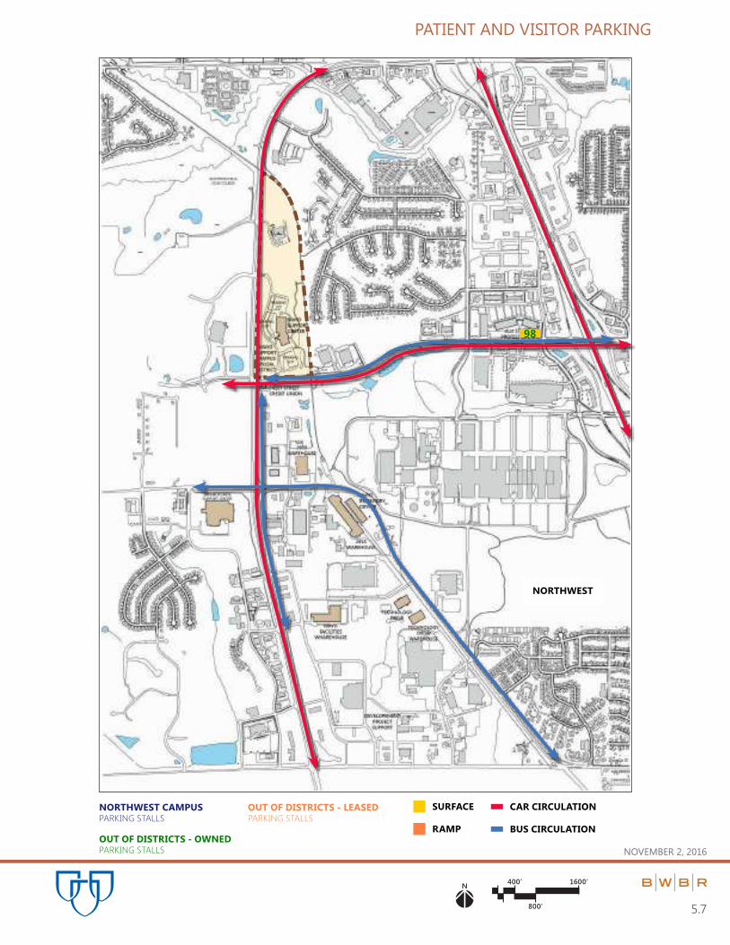
The tables and graphics on the following pages summarize parking facilities which directly support Mayo operations
within the City of Rochester, including employee, patient, and visitor parking. All data is current as of January 1, 2016.
Philosophy
It is the intent and policy of Mayo Clinic to continue to provide a comprehensive transportation program to meet the
needs of its patients, Staff, and Allied Health Staff. Patient and employee transportation needs represent a dynamic
situation necessitating constant balancing and adjustment. Mayo’s committed goal is to meet those needs, and provide
viable options for all. The further integration of all Mayo Clinic Rochester Campuses has leveraged opportunities for
cross-utilization of resources, improving flexibility for meeting evolving transportation and parking needs.
From 2009 - 2015, Mayo Clinic has received the “Best Workplace for Commuters Award.” This program serves to recognize employers offering commuter benefits and alternatives to drive- alone commuting. In addition to patient and
staff shuttles, Mayo provides parking for the Ronald McDonald House.
Transportation & Parking
Patients and Visitors – Once patients and visitors have arrived in Rochester, hotel/motel courtesy vans and the Gold Cross
Patient Shuttle significantly reduce the need for individual vehicles. The Mayo Patient Shuttle carries approximately 600
people per day between the Downtown and Saint Marys Campuses.
Downtown patient parking needs are met by 2,155 spaces located in three parking ramps and two surface lots, including
spaces for persons with disabilities.
The visitor/patient parking ramps on the Saint Marys Campus provide 719 spaces for patient use, including 29 reserved
for Emergency Room use, and designated spaces for persons with disabilities.
Staff, Residents and Allied Health Employees – Currently Mayo Clinic Rochester has 14,397 staff, resident, and Allied
Health employee parking spaces.
Central Campus – 7,150
West Campus – 2,411
Mayo Support Campus - 775
Outside Special Districts - 4,061 including thirteen off-site locations:
1. 922 - West Shuttle Lot located at 24th Avenue and Second Street Southwest
2. 887 - East Shuttle Lot located at 1st Avenue and 6th Street Southeast
3. 859 - Superior Drive Support Center, 3050 Superior Drive NW
4. 336 - Leased spaces in the Third Street City Ramp at 3rd Street and 1st Avenue Southwest
5. 264 - Northwest Clinic (41st Street Professional Building)
6. 248 - Technology Drive, 3434 Technology Drive NW
7. 163 - Northeast Clinic, 304 Stonehedge Drive NE
8. 131 - 2915 Building
9. 83 - Mayo Employee Federal Credit Union-Cascade Lake
10. 80 - Southeast Clinic
11. 35 - East Foundation House – Parking Lot 17
12. 28 - West Foundation House – Parking Lot 16
13. 25 - Mayo Employee Federal Credit Union-Canal Place

PART 5.0 | CAMPUS PARKING and VEHICULAR CIRCULATION
November 2, 2016
5.2
Historically, the estimated demand for and provision of employee parking has been about 50% of total employee
FTEs on the downtown and Saint Marys campuses.
Mayo encourages individuals to use alternate means of transportation so as to not further contribute to the
downtown traffic congestion and pollution, and to assist in energy conservation. This is accomplished through:
1. The subsidized bus program, utilized by over 13,300 + employees, offers convenient routes and monthly
discount passes. Employees depend upon this service which includes: Commuter service to surrounding
communities, and transit city bus service throughout the City of Rochester with designated park and ride
locations for Mayo Clinic.
2. Use of carpool vehicles, bicycles and motorcycles as alternative modes of transportation has been
encouraged with special parking privileges. Currently, Mayo Clinic Rochester has 840 individual employees in
280 car pools on both campuses. Mayo provides parking for up to 850 individual bicycles and approximately
300 motorcycles per day. Bicycle and motorcycle parking are easily expanded as demand requires.
3. The employee shuttle service carries over 4,000 employees daily between the medical sub-district campuses
to meet business needs, reducing the volume of vehicles traveling between sites during the workday.
4. Park and ride lots are used by approximately 900 to 1,000 employees daily. These lots are located at Chateau
Theater, IBM, Target South, Cub Foods SE, and Olmsted County Fairgrounds.
Approximately 50% of employees who qualify and accept campus parking privileges utilize parking on any given day.
This is due to varying shift schedules, vacations, education and meeting absences, as well as general business needs
outside of Rochester.

PART 5.0 | CAMPUS PARKING and VEHICULAR CIRCULATION
November 2, 2016
5.3
PATIENT | VISITOR PARKING CAPACITY SUMMARY (as of 12/31/2015)
CENTRAL SUB-DISTRICT (Downtown Campus)
(Patient | Visitor)
Parking Stalls
CODE PARKING RAMP 2011 2016
BR Baldwin Parking Ramp 8 151 151
CR Charter House Parking Ramp 178 178
DR Damon Parking Ramp 774 773
GP Graham Parking Ramp 927 928
PATIENT | VISITOR CENTRAL RAMP SUBTOTAL 2,030 2,030
Parking Stalls
CODE PARKING LOT 2011 2016
3 Baldwin Surface Lot 47 48
10 Parking Lot 10 0 58
19 Blood Bank 19 19
CENTRAL LOT SUBTOTAL 67 125
CENTRAL DISTRICT PATIENT | VISITOR PARKING TOTAL 2,097 2,155
WEST SUB-DISTRICT (Saint Marys Campus)
(Patient | Visitor)
Parking Stalls
CODE PARKING RAMP 2011 2016
WR Generose Parking Ramp 249 341
VR Mary Brigh Parking Ramp 337 349
WEST RAMP SUBTOTAL 586 690

PART 5.0 | CAMPUS PARKING and VEHICULAR CIRCULATION
November 2, 2016
5.4
WEST SUB-DISTRICT (Saint Marys Campus)
(Patient | Visitor) (Continued)
Parking Stalls
CODE PARKING LOT 2011 2016
SMC ER Parking 29 29
SMC West Door Surface Lot 13 0*
WEST LOT SUBTOTAL 29 29
WEST DISTRICT PATIENT | VISITOR PARKING TOTAL 628 719
* Included in Mary Brigh Parking Ramp

PART 5.0 | CAMPUS PARKING and VEHICULAR CIRCULATION
November 2, 2016
5.5
OUTSIDE of DISRICT (Mayo Owned or Leased)
(Patient | Visitor)
Parking Stalls
CODE PARKING RAMP | LOT 2011 2016
NE Mayo Family Clinic Northeast 188 123
NW Mayo Family Clinic Northwest 75 98
SE Mayo Family Clinic Southeast 80
MAYO OWNED SUBTOTAL 263 301
OUTSIDE OF DISTRICT PATIENT | VISITOR PARKING TOTAL 263 301
SUMMARY OF TOTALS
(Patient | Visitor)
Parking Stalls
PARKING RAMPS | LOTS 2011 2016
Central Sub-District Patient | Visitor Parking Total 2,097 2,155
West Sub-District Patient | Visitor Parking Total 628 719
Outside District Patient | Visitor Parking Total 263 301
MAYO ROCHESTER – PATIENT | VISITOR PARKING TOTAL 2,997 3,175

NOVEMBER 2, 2016
125’ 700’
350’
N
5.6
PATIENT AND VISITOR PARKING
349
29
341
151
48
19
58PKNG
LOT
10
773
928
178
5TH ST SW
6TH ST SW
7TH ST SW7TH ST SW
6TH ST SW
8TH ST SW
9TH ST SW
4TH ST SW
3RD ST SW
2ND ST SW
CENTER ST E
1ST ST NW
2ND ST NE
3RD ST NE3RD ST NW
2ND ST NW
1ST ST NE
CENTER ST E
1ST ST SE
2ND ST SE
4TH ST SE MN 296
4TH ST NE
5TH ST NW
8TH ST SW
7TH ST SW
5TH ST SW
4TH ST SW
3RD ST SW
2ND ST SW
1ST ST SW
W CENTER ST
1ST ST NW
2ND ST NW
3RD ST NW
4TH ST NW
2ND ST SW
1ST ST SW
W CENTER ST
1ST ST NW
2ND ST NW
4TH ST NW
4 1/2 ST SW
6TH ST SW
7TH ST SW
1ST
A
VE SW
2N
D A
VE SW
3R
D A
VE SW
4T
H A
VE SW
5T
H A
VE SW
6T
H A
VE SW
7T
H A
VE SW
8T
H A
VE SW
9T
H A
VE SW
10
TH
A
VE SW
6T
H A
VE SW
7T
H A
VE SW
9T
H A
VE SW
14
TH
A
VE SW
15
TH
A
VE SW
12
TH
AV
E SW
10TH ST SW
PLUM
MERS CIRCLE
6TH ST SW
15
TH
ST
SW
16
TH
ST
SW
13
TH
ST
N
W
12
TH
ST
N
W
11
TH
ST
N
W
16
TH
ST
N
W
16TH
AVE N
W
11
TH
A
VE N
W
7T
H A
VE N
W
6T
H A
VE N
W
5T
H A
VE N
W
4T
H A
VE N
W
3R
D A
VE N
W
1ST ST SW
1ST
A
VE N
W
BR
OA
DW
AY
1ST
A
VE N
E
2N
D A
VE N
E2
ND
A
VE SE
BR
OA
DW
AY
US 6
3
9T
H A
VE N
W
8 1/2
AVE
NW
8T
H A
VE N
W
CIVIC CENTER DRIVE
CIVIC CENTER DRIVECIVIC CENTER DRIVE
CIVIC CENTER DRIVE
CIVIC CENTER DRIVE
CIVIC CENTER DRIVE
TH
52
NB
& T
H 1
4 W
B
TH
52
SB
& T
H 1
4 E
B
TH
52 S
B &
TH
14 E
B
TH
52 N
B &
TH
14 W
B
2N
D A
VE N
W
DAMON
RAMP
GRAHAM
RAMP
MARY
BRIGH
PARKING
RAMP
GENEROSE
PARKING
RAMP
SMC ER
PARKING LOT
PARKING
LOT 3A
BLOOD
BANK
SAINT MARY’S CAMPUS
PARKING STALLS
DOWNTOWN CAMPUS
PARKING STALLS
OUT OF DISTRICTS - OWNED
PARKING STALLS
OUT OF DISTRICTS - LEASED
PARKING STALLS
SURFACE CAR CIRCULATIONRAMP BUS CIRCULATION
WEST CENTRAL
400’ 1600’
800’
N
PATIENT AND VISITOR PARKING
5.7
NOVEMBER 2, 2016
98
NORTHWEST CAMPUS
PARKING STALLS
OUT OF DISTRICTS - OWNED
PARKING STALLS
OUT OF DISTRICTS - LEASED
PARKING STALLS
SURFACE CAR CIRCULATION
RAMP BUS CIRCULATION
NORTHWEST

N mi. 2 mi.
1 mi.
1
2
4 mi. 5.8
MAYO PATIENT AND VISITOR PARKING
NOVEMBER 2, 2016
MAYO FAMILY
CLINIC NE
MAYO FAMILY CLINIC
SOUTHEAST
80
123
MAYO DISTRICTS PATIENT/VISITOR PARKING LOT

PART 5.0 | CAMPUS PARKING and VEHICULAR CIRCULATION
November 2, 2016
5.9
EMPLOYEE PARKING CAPACITY SUMMARY (as of 12/31/2015)
CENTRAL SUB-DISTRICT (Downtown Campus)
(Employee)
Parking Stalls
CODE PARKING RAMP 2011 2016
BR Baldwin Parking Ramp 8 540 543
DR Damon Parking Ramp 26 0
CR Charter House Parking Ramp 6 184
RE Employee East Parking Ramp 628 624
RW Employee West Parking Ramp 2,266 2,311
OR Ozmun Parking Ramp 21 492 486
12 First Street Ramp 12 828 828
CENTRAL RAMP SUBTOTAL 4,786 4,976
Parking Stalls
CODE PARKING LOT 2011 2016
1 Parking Lot 1 124 110
2 Parking Lot 2 288 294
3 Parking Lot 3 123 129
5 Parking Lot 5 14 12
6 Parking Lot 6 328 314
10 Parking Lot 10 58 0
11 Parking Lot 11 141 141
14 Parking Lot 14 80 0
15 Parking Lot 15 105 98
18 Christ United Methodist Church 159 159
19 Blood Bank 0 24
20 Parking Lot 20 97 98
22 Parking Lot 22 60 51
25 Parking Lot 25 55 56
26 Parking Lot 26 0 * 45
27 B’nai Synagogue 0 * 54
* Previously outside of Sub-District

PART 5.0 | CAMPUS PARKING and VEHICULAR CIRCULATION
November 2, 2016
5.10
CENTRAL SUB-DISTRICT (Downtown Campus)
(Employee) (Continued)
Parking Stalls
CODE PARKING LOT 2011 2016
28 Parking Lot 28 48 48
29 Parking Lot 29 140 194
30 Parking Lot 30 0 * 244
37 Parking Lot 37 106 103
24A North of Ozmun 11 0
CENTRAL LOT SUBTOTAL 1,937 2,174
CENTRAL DISTRICT EMPLOYEE PARKING TOTAL 6,723 7,150
WEST SUB-DISTRICT (Saint Marys Campus)
(Employee)
Parking Stalls
CODE PARKING RAMP 2011 2016
34 SMC East Employee Ramp – Parking Lot 34 1,158 1,162
WR Generose Parking Ramp 793 780
VR Mary Brigh Parking Ramp 120 109
WEST RAMP SUBTOTAL 2,071 2,051
Parking Stalls
CODE PARKING LOT 2011 2016
31 SMC Parking Lot 31 0 * 68
32 SMC Parking Lot 32 0 * 98
33 SMC Parking Lot 33 175 194
WEST LOT SUBTOTAL 175 360
WEST DISTRICT EMPLOYEE PARKING TOTAL 2,246 2,411
* Previously outside of Sub-District

PART 5.0 | CAMPUS PARKING and VEHICULAR CIRCULATION
November 2, 2016
5.11
MAYO SUPPORT CAMPUS SPECIAL DISTRICT (Northwest Campus)
(Employee)
Parking Stalls
CODE PARKING LOT 2011 2016
MSC Mayo Support Center Parking 700 775
MAYO SPECIAL DISTRICT LOT SUBTOTAL 700 775
MAYO SPECIAL DISTRICT EMPLOYEE PARKING TOTAL 700 775
OUTSIDE of DISRICT (Mayo Owned or Leased)
(Employee)
Parking Stalls
CODE PARKING RAMP | LOT 2011 2016
16 West Foundation House – Parking Lot 16 26 28
17 East Foundation House – Parking Lot 17 38 35
26 Parking Lot 26 47 0 *
27 B’nai Synagogue 47 0 *
30 Parking Lot 30 32 0 *
31 Parking Lot 31 53 0 *
32 Parking Lot 32 99 0 *
35 East Shuttle Lot – Parking Lot 35 909 887
36 West Shuttle Lot – Parking Lot 36 946 922
2915 2915 Building 0 131
CP Mayo Employee Federal Credit Union-Canal Place 25 25
CU Mayo Employee Federal Credit Union-Cascade Lake 83 83
NE Mayo Family Clinic Northeast 110 163
NW Mayo Family Clinic Northwest 288 264
SDSC Superior Drive Support Center 815 859
SE Mayo Family Clinic Southeast - 80
TD Technology Drive 0 248
TR Third Street Ramp (Rental Spaces) 346 336
MAYO OWNED SUBTOTAL 3,864 4,061
OUTSIDE of DISTRICT EMPLOYEE PARKING TOTAL 3,864 4,061
* No longer outside of the Medical Institutional Sub-Districts
PART 5.0 | CAMPUS PARKING and VEHICULAR CIRCULATION
November 2, 2016
5.12
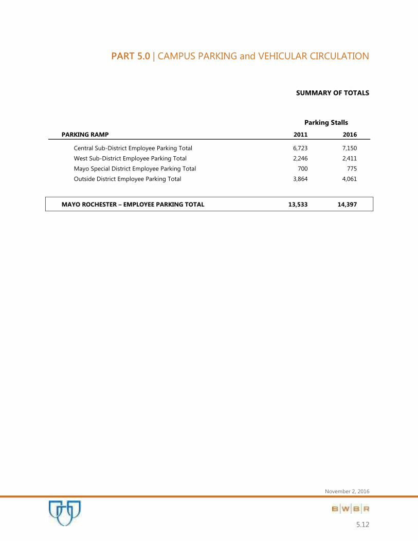
SUMMARY OF TOTALS
Parking Stalls
PARKING RAMP 2011 2016
Central Sub-District Employee Parking Total 6,723 7,150
West Sub-District Employee Parking Total 2,246 2,411
Mayo Special District Employee Parking Total 700 775
Outside District Employee Parking Total 3,864 4,061
MAYO ROCHESTER – EMPLOYEE PARKING TOTAL 13,533 14,397

NOVEMBER 2, 2016
125’ 700’
350’
N
5.13
EMPLOYEE PARKING & CIRCULATION
28
PARKING
LOT 16
PARKING
LOT 31
68 98PARKING
LOT 32
GENEROSE
PARKING
RAMP
780
PARKING
RAMP
EAST
(#34)
1,162
MARY
BRIGH RAMP
109194PARKING
LOT 33
110
GRAHAM
BLDG
294
PARKING
LOT 3
129
12
314
PARKING
LOT 6
PARKING
LOT 2
141
98
PARKING
LOT 15
159CHRIST
UNITED
METHODIST
CHURCH
24
PARKING
LOT 20 98
336
THIRD
STREET
PKNG
RAMP
EAST
SHUTTLE
LOT
#35
887
45PARKING
LOT 26
54PARKING
LOT 27
244
PARKING
LOT 30
543
184
624EAST
EMPLOYEE
RAMP
2,311
WEST
EMPLOYEE
RAMP
486
FIRST
STREET
RAMP
828
51
PARKING
LOT 22
56 PARKING
LOT 25
48
PARKING
LOT 28
PARKING
LOT 29
194
103
PARKING
LOT 37
35
PARKING
LOT 17
PARKING
LOT 11
PARKING
LOT 1
5TH ST SW
6TH ST SW
7TH ST SW7TH ST SW
6TH ST SW
8TH ST SW
9TH ST SW
4TH ST SW
3RD ST SW
2ND ST SW
CENTER ST E
1ST ST NW
2ND ST NE
3RD ST NE3RD ST NW
2ND ST NW
1ST ST NE
CENTER ST E
1ST ST SE
2ND ST SE
4TH ST SE MN 296
4TH ST NE
5TH ST NW
8TH ST SW
7TH ST SW
5TH ST SW
4TH ST SW
3RD ST SW
2ND ST SW
1ST ST SW
W CENTER ST
1ST ST NW
2ND ST NW
3RD ST NW
4TH ST NW
2ND ST SW
1ST ST SW
W CENTER ST
1ST ST NW
2ND ST NW
4TH ST NW
4 1/2 ST SW
6TH ST SW
7TH ST SW
1ST
A
VE SW
2N
D A
VE SW
3R
D A
VE SW
4T
H A
VE SW
5T
H A
VE SW
6T
H A
VE SW
7T
H A
VE SW
8T
H A
VE SW
9T
H A
VE SW
10
TH
A
VE SW
6T
H A
VE SW
7T
H A
VE SW
9T
H A
VE SW
14
TH
A
VE SW
15
TH
A
VE SW
12
TH
AV
E SW
10TH ST SW
PLUM
MERS CIRCLE
6TH ST SW
15
TH
ST
SW
16
TH
ST
SW
13
TH
ST
N
W
12
TH
ST
N
W
11
TH
ST
N
W
16
TH
ST
N
W
16TH
AVE N
W
11
TH
A
VE N
W
7T
H A
VE N
W
6T
H A
VE N
W
5T
H A
VE N
W
4T
H A
VE N
W
3R
D A
VE N
W
1ST ST SW
1ST
A
VE N
W
BR
OA
DW
AY
1ST
A
VE N
E
2N
D A
VE N
E2
ND
A
VE SE
BR
OA
DW
AY
US 6
3
9T
H A
VE N
W
8 1/2
AVE
NW
8T
H A
VE N
W
CIVIC CENTER DRIVE
CIVIC CENTER DRIVECIVIC CENTER DRIVE
CIVIC CENTER DRIVE
CIVIC CENTER DRIVE
CIVIC CENTER DRIVE
TH
52
NB
& T
H 1
4 W
B
TH
52
SB
& T
H 1
4 E
B
TH
52 S
B &
TH
14 E
B
TH
52 N
B &
TH
14 W
B
2N
D A
VE N
W
PARKING
LOT 5
BLOOD
BANK
SAINT MARY’S CAMPUS
PARKING STALLS
DOWNTOWN CAMPUS
PARKING STALLS
OUT OF DISTRICTS - OWNED
PARKING STALLS
OUT OF DISTRICTS - LEASED
PARKING STALLS
SURFACE CAR CIRCULATIONRAMP BUS CIRCULATION
WEST CENTRAL

400’ 1600’
800’
N
EMPLOYEE PARKING & CIRCULATION
5.14
NOVEMBER 2, 2016
264
248
SUPERIOR DRIVE
SUPPORT
CENTER
859
PKNG
LOT
PKNG
LOT
775
2915
BUILDING
131
25
NORTHWEST CAMPUS
PARKING STALLS
OUT OF DISTRICTS - OWNED
PARKING STALLS
OUT OF DISTRICTS - LEASED
PARKING STALLS
SURFACE CAR CIRCULATION
RAMP BUS CIRCULATION
NORTHWEST

N mi. 2 mi.
1 mi.
1
2
4 mi. 5.15
MAYO EMPLOYEE PARKING
NOVEMBER 2, 2016
WAL MART
PARK & RIDE
MAYO SUPPORT
CENTER
WEST SHUTTLE
LOT
SHOPKO
PARK & RIDE
CUB FOODS
PARK & RIDE
NORTH SHOPKO
PARK & RIDE
MAYO FAMILY
CLINIC NE
MAYO EMPLOYEE FEDERAL
CREDIT UNION CANAL PLACE
MAYO EMPLOYEE
FEDERAL CREDIT
UNION CASCADE LAKE
MAYO FAMILY CLINIC
SOUTHEAST
163
922
83
80
25
MAYO DISTRICTS PARK & RIDE SHUTTLE LOT

PART 6.0 | MATERIALS HANDLING and DISTRIBUTION,
SUBWAYS and SERVICE DOCKS
November 2, 2016
6.0

PART 6.0 | MATERIALS HANDLING and DISTRIBUTION,
SUBWAYS and SERVICE DOCKS
November 2, 2016
6.1
The graphics on the following pages illustrate the network for receiving and distributing materials in support of Mayo
Clinic operations at facilities throughout the city of Rochester.
Material Distribution Concept
The Mayo system for material receipt and distribution is predicated on the idea of decentralized receiving and storage
in order to reduce on-campus congestion and pollution.
Key Elements
Remote off-campus warehouses and docks are utilized for bulk receiving, storage, and breakout of over-the-
road shipments.
Peripheral on-campus docks are located for specific receiving and shipping to alleviate congestion and to be
proximate to end use or point of collection.
Interconnecting subway system allows low-impact movement of materials between docks and facilities.
Pneumatic tube and Electronic Track Vehicle (ETV) carry records, samples, and other small items within and
between most Mayo downtown and Saint Marys campus facilities.
Conversion to electronic technology for information storage and transfer; is substantially reducing the need
for mechanical transport of images, email, laboratory results, and medical records, etc.

NOVEMBER 2, 2016
125’ 700’
350’
N
6.2
MATERIALS DISTRIBUTION
CHRIST
UNITED
METHODIST
CHURCH
5
1
4
2
9
4
3
3
2
3
1
1
2
3 2
5TH ST SW
6TH ST SW
7TH ST SW7TH ST SW
6TH ST SW
8TH ST SW
9TH ST SW
4TH ST SW
3RD ST SW
2ND ST SW
CENTER ST E
1ST ST NW
2ND ST NE
3RD ST NE3RD ST NW
2ND ST NW
1ST ST NE
CENTER ST E
1ST ST SE
2ND ST SE
4TH ST SE MN 296
4TH ST NE
5TH ST NW
8TH ST SW
7TH ST SW
5TH ST SW
4TH ST SW
3RD ST SW
2ND ST SW
1ST ST SW
W CENTER ST
1ST ST NW
2ND ST NW
3RD ST NW
4TH ST NW
2ND ST SW
1ST ST SW
W CENTER ST
1ST ST NW
2ND ST NW
4TH ST NW
4 1/2 ST SW
6TH ST SW
7TH ST SW
1ST
A
VE SW
2N
D A
VE SW
3R
D A
VE SW
4T
H A
VE SW
5T
H A
VE SW
6T
H A
VE SW
7T
H A
VE SW
8T
H A
VE SW
9T
H A
VE SW
10
TH
A
VE SW
6T
H A
VE SW
7T
H A
VE SW
9T
H A
VE SW
14
TH
A
VE SW
15
TH
A
VE SW
12
TH
AV
E SW
10TH ST SW
PLUM
MERS CIRCLE
6TH ST SW
15
TH
ST
SW
16
TH
ST
SW
13
TH
ST
N
W
12
TH
ST
N
W
11
TH
ST
N
W
16
TH
ST
N
W
16TH
AVE N
W
11
TH
A
VE N
W
7T
H A
VE N
W
6T
H A
VE N
W
5T
H A
VE N
W
4T
H A
VE N
W
3R
D A
VE N
W
1ST ST SW
1ST
A
VE N
W
BR
OA
DW
AY
1ST
A
VE N
E
2N
D A
VE N
E2
ND
A
VE SE
BR
OA
DW
AY
US 6
3
9T
H A
VE N
W
8 1/2
AVE
NW
8T
H A
VE N
W
CIVIC CENTER DRIVE
CIVIC CENTER DRIVECIVIC CENTER DRIVE
CIVIC CENTER DRIVE
CIVIC CENTER DRIVE
CIVIC CENTER DRIVE
TH
52
NB
& T
H 1
4 W
B
TH
52
SB
& T
H 1
4 E
B
TH
52 S
B &
TH
14 E
B
TH
52 N
B &
TH
14 W
B
2N
D A
VE N
W
EXISTING SKYWAYS EXISTING SUBWAYS PNEUMATIC TUBE FUTURE MINOR DOCKSMAJOR DOCKS
w/No. OF DOCK BAYS2
WEST CENTRAL

400’ 1600’
800’
N
MATERIALS DISTRIBUTION
6.3
NOVEMBER 2, 2016
2
8
22
7
2
5
1
1
2
MAJOR DOCKS
w/No. OF DOCK BAYS2
NORTHWEST

N mi. 2 mi.
1 mi.
1
2
4 mi. 6.4
MATERIALS DISTRIBUTION
NOVEMBER 2, 2016
MAYO FAMILY
CLINIC NE
INSTITUTE
HILLS FARM
FRANKLIN
MAINTENANCE
FACILITY
WASTE MANAGEMENT
FACILITY
1
2
4
1
1 MAYO FAMILY
CLINIC SOUTHEAST
MAJOR DOCKS
w/No. OF DOCK BAYS2

PART 7.0 | UTILITY INFRASTRUCTURE
November 2, 2016
7.0

PART 7.0 | UTILITY INFRASTRUCTURE
November 2, 2016
7.1
The graphics on the following pages illustrate the network for producing and distributing utilities throughout the
Downtown and Saint Marys campuses. Generation of Mayo’s steam, chilled water, and electricity is centered around
Franklin Heating Station, Prospect Utility Plant, and Saint Marys Power Plant. Distribution occurs through the subway
utility tunnels.
Current and Proposed Improvements
Electrical distribution ties occur between campuses.
Redundant communication networks, utilizing fiber optic cables, connect both campuses and nearly all Mayo
buildings.
The installation of gas turbine electrical generation at Saint Marys is completed.
Steam capacity has been increased with a direct buried connection from the Rochester Public Utilities Silver
Lake Plant to the Prospect Utility Plant.
Utility tunnels have been extended as part of the new Jacobson Building.
Strategies for future provision of steam, chilled water, and electrical utilities are being studied. Potential
routes for extension of the utility tunnel loop are also being planned for potential growth in the Central Sub-
District. The potential for adding production capacity at the north and south perimeters of the downtown
campus is under consideration in response to growth projections.

NOVEMBER 2, 2016
125’ 700’
350’
N
7.2
UTILITIES INFRASTRUCTURE
UTILITY
PLANT
PROSPECT
UTILITY PLANT
FRANKLIN
HEATING
STATION
5TH ST SW
6TH ST SW
7TH ST SW7TH ST SW
6TH ST SW
8TH ST SW
9TH ST SW
4TH ST SW
3RD ST SW
2ND ST SW
CENTER ST E
1ST ST NW
2ND ST NE
3RD ST NE3RD ST NW
2ND ST NW
1ST ST NE
CENTER ST E
1ST ST SE
2ND ST SE
4TH ST SE MN 296
4TH ST NE
5TH ST NW
8TH ST SW
7TH ST SW
5TH ST SW
4TH ST SW
3RD ST SW
2ND ST SW
1ST ST SW
W CENTER ST
1ST ST NW
2ND ST NW
3RD ST NW
4TH ST NW
2ND ST SW
1ST ST SW
W CENTER ST
1ST ST NW
2ND ST NW
4TH ST NW
4 1/2 ST SW
6TH ST SW
7TH ST SW
1ST
A
VE SW
2N
D A
VE SW
3R
D A
VE SW
4T
H A
VE SW
5T
H A
VE SW
6T
H A
VE SW
7T
H A
VE SW
8T
H A
VE SW
9T
H A
VE SW
10
TH
A
VE SW
6T
H A
VE SW
7T
H A
VE SW
9T
H A
VE SW
14
TH
A
VE SW
15
TH
A
VE SW
12
TH
AV
E SW
10TH ST SW
PLUM
MERS CIRCLE
6TH ST SW
15
TH
ST
SW
16
TH
ST
SW
13
TH
ST
N
W
12
TH
ST
N
W
11
TH
ST
N
W
16
TH
ST
N
W
16TH
AVE N
W
11
TH
A
VE N
W
7T
H A
VE N
W
6T
H A
VE N
W
5T
H A
VE N
W
4T
H A
VE N
W
3R
D A
VE N
W
1ST ST SW
1ST
A
VE N
W
BR
OA
DW
AY
1ST
A
VE N
E
2N
D A
VE N
E2
ND
A
VE SE
BR
OA
DW
AY
US 6
3
9T
H A
VE N
W
8 1/2
AVE
NW
8T
H A
VE N
W
CIVIC CENTER DRIVE
CIVIC CENTER DRIVECIVIC CENTER DRIVE
CIVIC CENTER DRIVE
CIVIC CENTER DRIVE
CIVIC CENTER DRIVE
TH
52
NB
& T
H 1
4 W
B
TH
52
SB
& T
H 1
4 E
B
TH
52 S
B &
TH
14 E
B
TH
52 N
B &
TH
14 W
B
2N
D A
VE N
W
COMMUNICATION LINE CHILLED WATERELECTRICAL LINE STEAM LINE FUTURE UTILITY
0.0212 IN
POTENTIAL SITES FOR FUTURE UTILITY PLANT
WEST CENTRAL

PART 8.0 | URBAN GREEN SPACE
November 2, 2016
8.0

PART 8.0 | URBAN GREEN SPACE
November 2, 2016
8.1
The graphics on the following pages present a landscape framework of public and private lands that together can
create a unique green space network in Rochester, particularly in the center of the City. Mayo is committed to
improving and expanding green spaces on its campuses, as evidenced by a number of significant open space
developments which already exist. Mayo also intends to monitor DMC-related urban planning recommendations
related to urban green space.
Public Parklands
The area in and around the Special Medical Districts has substantial public parklands including Soldiers' Field and
Saint Marys Park to the south, and Kutzky Park to the northwest. Central Park and the Zumbro River Corridor also
provide open space opportunities in central Rochester.
The downtown Mayo campus is located between the Zumbro River and Cascade Creek, which have benefitted from
many improvements due to floodway infrastructure. With its large campus area, Saint Marys has significant
topographic and open green space attributes.
Gateways and Campus Portals
Gateway locations have been established at the campus edges where vehicles enter from multiple directions. This
includes portals at the north end of 3rd /4th Avenues at Civic Center Drive and at the west end of 2nd Street
Southwest at 14th Avenue (near its intersection with Highway 52). A gateway is also planned for the northern portal
to the Saint Marys campus at the intersection of 2nd Street and 11th Avenue Southwest as part of the DMC Saint Marys
Place. As the southern edge of the downtown campus is developed, locations under consideration for additional
portal identification include intersections along 6th Street Southwest near Broadway, particularly at the convergence of
the University of Minnesota Rochester and Mayo campuses. Campus portals can be structural and/or landscaped
places which respond to the context of each proposed gateway.
As for pedestrian portals between individual DMC districts, wayfinding or place-making elements will be considered
along with landscape and structural elements. The location of these portals will emerge as the design of individual
DMC districts occur.
Boulevards
Several area streets are important to the character of both the Mayo campuses and downtown Rochester. So it would
be appropriate to treat them as boulevards with trees, special lighting, and landscaping. Recently completed
upgrades include the north side of 2nd Street Southwest, where boulevard tree planting has been completed, and the
boulevards fronting the Jacobsen Building. Other targeted areas include Civic Center Drive, Broadway, and 6th Street
Southwest from Broadway to 4th Avenue. Growing conditions for boulevard plantings have been improved with the
adoption of policies which reduce winter salt usage and parking lot runoff. Modified snow removal techniques are
also beneficial.
The 3rd and 4th Avenues corridor, extending north-south through the Mayo Clinic downtown campus, has the
potential for the development of a sequence of gardens and small parks, one of which has already been established
south of the Harwick Building and another with the new Statuary Park developed at the Gonda Building entry. As a
linkage with such parks, the frontage along both streets should be fully landscaped from 6th Street Southwest to Civic
Center Drive. Given the density of zero lot line structures in this corridor, new structures should allow for green space
development where possible.

PART 8.0 | URBAN GREEN SPACE
November 2, 2016
8.2
The 4th Street and 6th Street Southwest corridors each have their own special residential character, which should be
respected between the Saint Marys campus and South Broadway, as they are upgraded with lighting and plantings.
Green Spaces and Places
Mayo continues to establish and maintain small, landscaped green spaces in the downtown campus to improve the
public perception and experience. The green spaces include the Annenberg Plaza and the Feith Family Statuary Park
at the Mayo/Gonda Building complex, the south lawn, sculpture court and green spaces at the Ozmun Building, the
south courtyard at the Harwick Building, and numerous other small spaces which contribute to the network of urban
green space, which now includes 3 new rain gardens to help slow surface run-off.
The 50+ acre Saint Marys campus has significant green space with the sensitively landscaped buffer along 10th
Avenue and 6th Street Southwest, as well as highly developed areas such as the Peace Garden and Edith Graham
Courtyard. The Patient Plaza and green space at the Mayo Campus Gateway at 14th Avenue and 2nd Street is made
possible by locating the visitor parking underground.
At the Superior Drive Support Center campus, 2.5 acres of new landscaping has been installed, including 2,500
perennials and 40 trees, along with a storm water detention pond.
Mayo continues to landscape and green its open spaces as opportunities occur, and supports others, such as the
Calvary Episcopal, St. Johns Church and the Hope Lodge which provide very important contemplative spaces in and
around the medical campus.
As the campus continues to develop, the goal of providing an enhanced patient experience may suggest the need to
vacate certain streets, such as 3rd Street between 2nd and 3rd Avenues Southwest to provide significant green/open
space, and provide texture and color for pedestrian areas.
Green Pathways
Enhanced Pedestrian and Bike Path connections should be established through the Kutzky neighborhood linking
Cascade Creek with the Saint Marys Campus as well as a link from the Cascade Creek Pedestrian/Bike Path into
Downtown. Similarly, connections to the Zumbro River Paths and to Soldiers Field should be encouraged.

NOVEMBER 2, 2016
125’ 700’
350’
N
8.3
URBAN GREEN SPACE
SOUTH
GATEWAY
HARWICK
PLAZA
GARDEN
OZMUN
PARK
FEITH FAMILY
STATUARY
PARK
PARK
WEST
GATEWAY
PEACE
GARDEN
WEST
PORTAL
TO CITY
NORTH
GATEWAY CENTRAL
PARK
GREEN
GONDA
GARDEN
COURT
MATTHEW
DOME
BOULEVARD
SOLDIERS
FIELD
GREEN SPACE
KUTZKY
PARK
ANNENBERG
PLAZA
GREEN
GREEN
GREEN GREEN
GREEN
5TH ST SW
6TH ST SW
7TH ST SW7TH ST SW
6TH ST SW
8TH ST SW
9TH ST SW
4TH ST SW
3RD ST SW
2ND ST SW
CENTER ST E
1ST ST NW
2ND ST NE
3RD ST NE3RD ST NW
2ND ST NW
1ST ST NE
CENTER ST E
1ST ST SE
2ND ST SE
4TH ST SE MN 296
4TH ST NE
5TH ST NW
8TH ST SW
7TH ST SW
5TH ST SW
4TH ST SW
3RD ST SW
2ND ST SW
1ST ST SW
W CENTER ST
1ST ST NW
2ND ST NW
3RD ST NW
4TH ST NW
2ND ST SW
1ST ST SW
W CENTER ST
1ST ST NW
2ND ST NW
4TH ST NW
4 1/2 ST SW
6TH ST SW
7TH ST SW
1ST
A
VE SW
2N
D A
VE SW
3R
D A
VE SW
4T
H A
VE SW
5T
H A
VE SW
6T
H A
VE SW
7T
H A
VE SW
8T
H A
VE SW
9T
H A
VE SW
10
TH
A
VE SW
6T
H A
VE SW
7T
H A
VE SW
9T
H A
VE SW
14
TH
A
VE SW
15
TH
A
VE SW
12
TH
AV
E SW
10TH ST SW
PLUM
MERS CIRCLE
6TH ST SW
15
TH
ST
SW
16
TH
ST
SW
13
TH
ST
N
W
12
TH
ST
N
W
11
TH
ST
N
W
16
TH
ST
N
W
16TH
AVE N
W
11
TH
A
VE N
W
7T
H A
VE N
W
6T
H A
VE N
W
5T
H A
VE N
W
4T
H A
VE N
W
3R
D A
VE N
W
1ST ST SW
1ST
A
VE N
W
BR
OA
DW
AY
1ST
A
VE N
E
2N
D A
VE N
E2
ND
A
VE SE
BR
OA
DW
AY
US 6
3
9T
H A
VE N
W
8 1/2
AVE
NW
8T
H A
VE N
W
CIVIC CENTER DRIVE
CIVIC CENTER DRIVE
CIVIC CENTER DRIVE
CIVIC CENTER DRIVE
CIVIC CENTER DRIVE
CIVIC CENTER DRIVE
TH
52
NB
& T
H 1
4 W
B
TH
52
SB
& T
H 1
4 E
B
TH
52 S
B &
TH
14 E
B
TH
52 N
B &
TH
14 W
B
2N
D A
VE N
W
GREEN SPACE
MAJOR PARKWAYS TRANSIT CORRIDORMAYO PARK AND GREEN SPACE GATEWAY LOCATIONS CITY PARKS AND GREEN SPACE
WEST CENTRAL

400’ 1600’
800’
N
URBAN GREEN SPACE
8.4
NOVEMBER 2, 2016
NORTHERN
HILLS GOLF
COURSE
FRANK
CANINE
PARK
NORTH
NORTHERN
HILLS
PRAIRIE
LINCOLNSHIRE
ARBOR
GLEN PARK
PEDESTRIAN ZONEPARKS AND GREEN SPACE
NORTHWEST

N mi. 2 mi.
1 mi.
1
2
4 mi. 8.5
URBAN GREEN SPACE
NOVEMBER 2, 2016
PARKS AND GREEN SPACE

PART 9.0 | POTENTIAL PROJECTS: Central Sub-District and West Sub-District
Mayo Support Campus Special District
Outside the Medical Institutional and Special Districts
November 2, 2016
9.0

PART 9.0 | POTENTIAL PROJECTS: Central Sub-District and West Sub-District
Mayo Support Campus Special District
Outside the Medical Institutional and Special Districts
November 2, 2016
9.1
POTENTIAL PROJECTS
The following pages contain a listing of potential Mayo projects, which may occur within the Central and West Sub-
Districts and the Mayo Support Campus Special District during the next five years.
The list of potential projects is divided by probable function, either Medical, Parking or Support, and are assigned a
number designation on the attached graphic illustration, which corresponds to an approximate location within the
Central Sub-District (Downtown Campus), West Sub-District (Saint Marys Campus), and Mayo Support Campus
Special District.
With the changes that are occurring within the health care sector, there is no certainty that all of these potential
projects will occur. DMC-related decisions may also impact project locations.
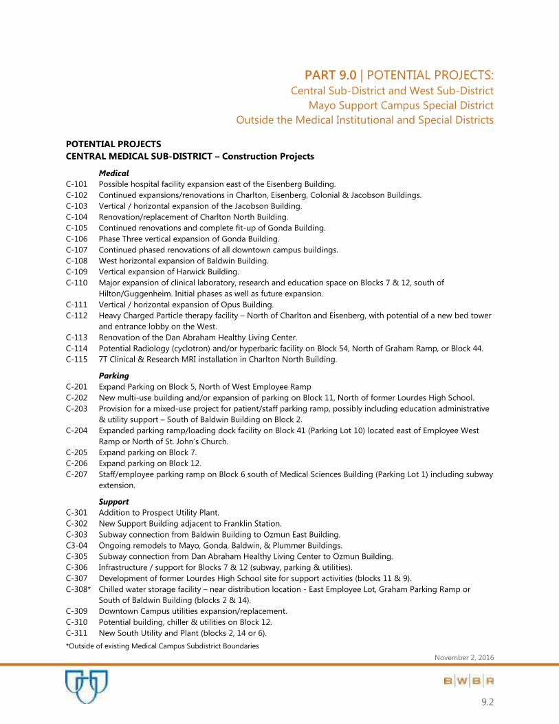
PART 9.0 | POTENTIAL PROJECTS: Central Sub-District and West Sub-District
Mayo Support Campus Special District
Outside the Medical Institutional and Special Districts
November 2, 2016
9.2
POTENTIAL PROJECTS
CENTRAL MEDICAL SUB-DISTRICT – Construction Projects
Medical
C-101 Possible hospital facility expansion east of the Eisenberg Building.
C-102 Continued expansions/renovations in Charlton, Eisenberg, Colonial & Jacobson Buildings.
C-103 Vertical / horizontal expansion of the Jacobson Building.
C-104 Renovation/replacement of Charlton North Building.
C-105 Continued renovations and complete fit-up of Gonda Building.
C-106 Phase Three vertical expansion of Gonda Building.
C-107 Continued phased renovations of all downtown campus buildings.
C-108 West horizontal expansion of Baldwin Building.
C-109 Vertical expansion of Harwick Building.
C-110 Major expansion of clinical laboratory, research and education space on Blocks 7 & 12, south of
Hilton/Guggenheim. Initial phases as well as future expansion.
C-111 Vertical / horizontal expansion of Opus Building.
C-112 Heavy Charged Particle therapy facility – North of Charlton and Eisenberg, with potential of a new bed tower
and entrance lobby on the West.
C-113 Renovation of the Dan Abraham Healthy Living Center.
C-114 Potential Radiology (cyclotron) and/or hyperbaric facility on Block 54, North of Graham Ramp, or Block 44.
C-115 7T Clinical & Research MRI installation in Charlton North Building.
Parking
C-201 Expand Parking on Block 5, North of West Employee Ramp
C-202 New multi-use building and/or expansion of parking on Block 11, North of former Lourdes High School.
C-203 Provision for a mixed-use project for patient/staff parking ramp, possibly including education administrative
& utility support – South of Baldwin Building on Block 2.
C-204 Expanded parking ramp/loading dock facility on Block 41 (Parking Lot 10) located east of Employee West
Ramp or North of St. John’s Church. C-205 Expand parking on Block 7.
C-206 Expand parking on Block 12.
C-207 Staff/employee parking ramp on Block 6 south of Medical Sciences Building (Parking Lot 1) including subway
extension.
Support
C-301 Addition to Prospect Utility Plant.
C-302 New Support Building adjacent to Franklin Station.
C-303 Subway connection from Baldwin Building to Ozmun East Building.
C3-04 Ongoing remodels to Mayo, Gonda, Baldwin, & Plummer Buildings.
C-305 Subway connection from Dan Abraham Healthy Living Center to Ozmun Building.
C-306 Infrastructure / support for Blocks 7 & 12 (subway, parking & utilities).
C-307 Development of former Lourdes High School site for support activities (blocks 11 & 9).
C-308* Chilled water storage facility – near distribution location - East Employee Lot, Graham Parking Ramp or
South of Baldwin Building (blocks 2 & 14).
C-309 Downtown Campus utilities expansion/replacement.
C-310 Potential building, chiller & utilities on Block 12.
C-311 New South Utility and Plant (blocks 2, 14 or 6).
*Outside of existing Medical Campus Subdistrict Boundaries

PART 9.0 | POTENTIAL PROJECTS: Central Sub-District and West Sub-District
Mayo Support Campus Special District
Outside the Medical Institutional and Special Districts
November 2, 2016
9.3
POTENTIAL PROJECTS
WEST MEDICAL SUB-DISTRICT – Construction Projects
Medical
W-101 Inpatient expansion 2nd St. SW and 11th Avenue SW
W-102 Continued phased renovation of all Saint Marys Campus buildings.
W-103 East expansion of Mary Brigh Building for diagnostic, treatment and inpatient functions.
W-104 Horizontal and vertical expansion of the Generose Building.
W-105 Bed tower expansion of East Mary Brigh Building.
W-106 Partial or full enclosure of Edith Graham Courtyard for patient and family functions. Upgrade landscape
treatment of Francis Courtyard.
W-107 Vertical expansion above the Mary Brigh Underground Visitor/Staff Parking Ramp, South of the entry plaza.
W-108 Continued campus planning, renovation and regeneration for medical uses.
Parking
W-201 Administrative support and parking facility on 11th Avenue SW and 2nd Street SW.
W-202 Parking Ramp expansion East of the Generose Employee Ramp.
Support
W-301* Administration building with parking ramp (W-201), or north across 2nd Street SW.
W-302* Herman House - Psychiatric Transitional Care Facility, west of 14th Avenue.
W-303 Extension of circulation spine from East Mary Brigh to the Chapel.
W-304 Pedestrian skyway from Mary Brigh Building to Generose Building.
W-305* Skyway/subway connections north across Second Street and/or west across 14th Avenue SW.
W-306 Expansion of Saint Marys Power Plant & utility distribution.
W-307 Campus Entrance at 11th Avenue and 2nd Street SW.
W-308 Consolidation of Docks.
W-309 Renovation of Saint Marys Convent.
W-310 Skyway from Old Marian Hall to Alfred Building.
W-311 Saint Marys Campus utilities expansion.
*Outside of existing Medical Campus Overlay Zones

NOVEMBER 2, 2016
125’ 700’
350’
N
9.4
POTENTIAL PROJECTS
W-305*
LAUNDRY
CONVENT
C-202
W-102W-307 W-301
W-201
W-108W-309
W-303
W-101
W-306
W-202
W-105
W-311
W-106
W-310
W-103
W-302
W-305
W-107
W-101
W-304
W-308W-104
C-201
C-307
C-113
C-204
C-301
C-114
C-112
C-114C-115
C-103
C-102
C-101
C-305
C-303
C-105
C-106
C-304
C-107
C-108C-109
C-302
C-203
C-111
C-110
C-306
C-310
C-205C-207
C-206
5TH ST SW
6TH ST SW
7TH ST SW7TH ST SW
6TH ST SW
8TH ST SW
9TH ST SW
4TH ST SW
3RD ST SW
2ND ST SW
CENTER ST E
1ST ST NW
2ND ST NE
3RD ST NE3RD ST NW
2ND ST NW
1ST ST NE
CENTER ST E
1ST ST SE
2ND ST SE
4TH ST SE MN 296
4TH ST NE
5TH ST NW
8TH ST SW
7TH ST SW
5TH ST SW
4TH ST SW
3RD ST SW
2ND ST SW
1ST ST SW
W CENTER ST
1ST ST NW
2ND ST NW
3RD ST NW
4TH ST NW
2ND ST SW
1ST ST SW
W CENTER ST
1ST ST NW
2ND ST NW
4TH ST NW
4 1/2 ST SW
6TH ST SW
7TH ST SW
1ST
A
VE SW
2N
D A
VE SW
3R
D A
VE SW
4T
H A
VE SW
5T
H A
VE SW
6T
H A
VE SW
7T
H A
VE SW
8T
H A
VE SW
9T
H A
VE SW
10
TH
A
VE SW
6T
H A
VE SW
7T
H A
VE SW
9T
H A
VE SW
14
TH
A
VE SW
15
TH
A
VE SW
12
TH
AV
E SW
10TH ST SW
PLUM
MERS CIRCLE
6TH ST SW
15
TH
ST
SW
16
TH
ST
SW
13
TH
ST
N
W
12
TH
ST
N
W
11
TH
ST
N
W
16
TH
ST
N
W
16TH
AVE N
W
11
TH
A
VE N
W
7T
H A
VE N
W
6T
H A
VE N
W
5T
H A
VE N
W
4T
H A
VE N
W
3R
D A
VE N
W
1ST ST SW
1ST
A
VE N
W
BR
OA
DW
AY
1ST
A
VE N
E
2N
D A
VE N
E2
ND
A
VE SE
BR
OA
DW
AY
US 6
3
9T
H A
VE N
W
8 1/2
AVE
NW
8T
H A
VE N
W
CIVIC CENTER DRIVE
CIVIC CENTER DRIVECIVIC CENTER DRIVE
CIVIC CENTER DRIVE
CIVIC CENTER DRIVE
CIVIC CENTER DRIVE
TH
52
NB
& T
H 1
4 W
B
TH
52
SB
& T
H 1
4 E
B
TH
52 S
B &
TH
14 E
B
TH
52 N
B &
TH
14 W
B
2N
D A
VE N
W
C-311
C-311
W-302
0.0212 IN
SAINT MARY’S CAMPUS
POTENTIAL PROJECTS5 5 CENTRAL CAMPUS
POTENTIAL PROJECTS
WEST CENTRAL

PART 9.0 | POTENTIAL PROJECTS: Central Sub-District and West Sub-District
Mayo Support Campus Special District
Outside the Medical Institutional and Special Districts
November 2, 2016
9.5
POTENTIAL PROJECTS
MAYO SUPPORT CENTER SUB-DISTRICT – Construction Projects
Medical
S-101 Northwest Primary Care Clinic.
Parking
S-201 Parking ramp at South.
S-202 Parking ramp at North.
Support
S-301 Administration office and support buildings.
S-302 Underground utilities loop.
S-303 Phased renovation of all buildings in district.

400’ 1600’
800’
N
POTENTIAL PROJECTS
9.6
NOVEMBER 2, 2016
S-202
S-301
S-101S-201
S-302S-303
NORTHWEST CAMPUS
POTENTIAL PROJECTS5
NORTHWEST

PART 9.0 | POTENTIAL PROJECTS: Central Sub-District and West Sub-District
Mayo Support Campus Special District
Outside the Medical Institutional and Special Districts
November 2, 2016
9.7
POTENTIAL PROJECTS
OUTSIDE MEDICAL SUB-DISTRICTS – Other Potential Planning / Projects
1. Continued study of personal transport system between Downtown, Saint Marys Campus, and beyond.
2. Support for construction of a Downtown Transportation Center.
3. Support for medical-hospital housing, medically related retail, and service functions along Second Street SW.
properties.
4. Expansion of Archive Warehouse to the North.
5. Expansion of Facilities Warehouse.
6. Construction of an Employee Parking Ramp and Support Building at South Warehouse site.
7. Construction of off-campus utility plant.
8. Expansion of Waste Management Facility.
9. Institute Hills Farm research support facilities renovation & expansion.
10. Development of South or Southwest property for Primary Care.
11. Expansion / renovation of Northwest warehouse facilities for clinical, administration and/or research
activities.
12. New laundry/support facility.
13. Provision of freezer storage warehouse (2915 Warehouse).
14. Expansion of Technology Drive Warehouse or creation of additional office space in NW.
15. Replacement of materials transport, utility and pneumatic tube connections between Central and West Sub-
districts (to be coordinated with reconstruction of 1st Avenue SW).
16. Expansion of Mayo Family Clinic Northeast.
17. Expansion of Superior Drive Support Center.
18. Lab Expansion (SDSC Phase II Building).
19. Lab Expansion (SDSC Phase II Parking Ramp).
20. Building renovation of 41st Street Building. 3 buildings potential parking ramp on north side.
21. Cell therapy lab/GMP facility (potential locations- DMC district, NW Warehouse, 41st Street Building).
22. Phased renovation of all buildings in district.

PART 10.0 | APPENDICES:
November 2, 2016
Glossary of Terms
City Plat Block Numbers
Building Addresses and Abbreviations
Central Development Core Zoning District Regulations
Medical Institutional Campus Special District: Zoning Ordinances #2726 (1991),
#3669 (2004) & #4052 (2011)
Mayo Support Campus Special District: Zoning Ordinance #3534 (2003)

PART 10.0 | APPENDICES:
November 2, 2016
GLOSSARY OF TERMS

PART 10.0 | APPENDICES:
November 2, 2016
GLOSSARY OF TERMS
BGSF (Building Gross Square Feet)
The total area of a facility including outside walls, mechanical spaces and canopies.
BUILDABLE AREA
The area of a lot remaining after the minimum yard or setback requirements have been met.
FAR (Floor Area Ratio) - Individual Parcel
The ratio of the total floor area of buildings on a certain location to the size of the lot it is on, or the limit
imposed on such a ratio. A F.A.R. of 2.0 indicates that the total floor area of a building is two times the gross
area of the plot on which it is constructed, as would be found in a multiple-story building.
FAR (Floor Area Ratio) - Overlay Zone
The ratio of the total floor area of buildings within the overlay zone to the area of property owned within the
overlay zone and transition zones, or the limit imposed on such a ratio. A F.A.R. of 2.0 indicates that the total
floor area of Mayo buildings is two times the gross area of Mayo's land area within the overlay & transition
zones.
FTE (Full Time Equivalent)
A unit to measure employed persons or students in a way that makes them comparable although they may
work or study a different number of hours per week.
INFRASTRUCTURE
The underlying foundation, framework and system supporting a building or city, including roads, water
supply, sewers, electrical grids, telecommunications, etc.
NON-CONTIGUOUS SUPPORT
To minimize congestion and other potential impacts, Mayo Clinic has decentralized many Support Facilities
to dispersed sites outside the Primary Medical-Institutional areas where possible. Buildings on these non-
contiguous parcels are subject to underlying, existing zoning code provisions.
PRIMARY MEDICAL INSTITUTIONAL
The two areas, which correspond to the Mayo Clinic and Rochester Methodist Hospital ("Central Sub-
District") and Saint Marys Hospital ("West Sub-District") campuses, create a Medical Institutional Special
District with two sub-districts, each with their own zoning constraints. These two areas include the core of
Mayo Clinic institutional uses, In-Patient and Out-Patient Medical Care as well as Education and Research
functions and related medical support functions.
PUBLIC UTILITY
Any person, corporation or government entity supplying gas, electric, transportation, water, sewer or land
line telephone service to the general public.
PART 10.0 | APPENDICES:
November 2, 2016
SETBACK
The minimum separation in linear feet, measured on a horizontal plane, required between the wall of a
building and each of its lot lines at a given height.
SITE AREA
All land area within the site as defined in the deed. Area shall be from an actual site survey rather than from
a deed description.
SPECIAL DISTRICT
The effect of a special district designation shall be as an overlay district. The regulations established in
special district legislation shall supersede the regulations of the underlying zoning district. To the extend
they are not inconsistent with the special district regulations, the underlying zoning district requirements
shall remain in effect.
TRANSITION AREA(S)
Transition Areas are located at the periphery of both the Central and West Primary Medical-Institutional Sub-
Districts. These are intended to provide a buffer, or physical transition, between large-scale, active uses and
adjacent neighborhood residential. Some Primary Medical-institutional uses may occur in transition areas,
which will have more zoning restrictions, although the emphasis in such areas will be Extended-Care,
Housing and Support Functions.
USE
The purpose or activity for which land or buildings are designed, arranged or intended, or for which land or
buildings are occupied or maintained.
ZONING MAP
The map or maps which are a part of city ordinances and delineate the boundaries of the zoning districts.

PART 10.0 | APPENDICES:
November 2, 2016
CITY PLAT BLOCK NUMBERS

NOVEMBER 2, 2016
125’ 700’
350’
N
BLOCK NUMBERS
5
2
4 70 71 72 73 74A
B
6465666768693
3
6
7 2 56 57 58 59 6061
62
4950515253545518
5 4 42 43 44 45 4647 48 78
793536373839404136
7 2 28 2930
31 32 33 34 80
81
20
212223242526271
115 16 17 18 19
82
10111213142
3 5 6 7 8 9 87 86 85
91100102 10112344
5 90 89 88
107
103 9296
95
939497
98
104106
6
11
10
WEST CENTRAL

PART 10.0 | APPENDICES:
November 2, 2016
BUILDING ADDRESSES AND ABBREVIATIONS
MAYO PARKING MAPS

BLDG_CODE LOC_DESC ADDRESS1 ADDRESS2 CITY STATE ZIP
AH ASSISI HEIGHTS 1001 14TH ST NW ROCHESTER MN 55901
AI ROCHESTER INTERNATIONAL AIRPORT 7600 HELGERSON DR SW ROCHESTER MN 55902
AL ALFRED BUILDING 1216 2ND ST SW ROCHESTER MN 55905
AM AIRPORT MAINTENANCE BUILDING 7600 HELGERSON DR SW ROCHESTER MN 55902
AS ASSOCIATED BANK BUILDING 206 SOUTH BROADWAY ROCHESTER MN 55901
AW ARCHIVE WAREHOUSE 835 5TH ST NW ROCHESTER MN 55901
BA BALDWIN BUILDING 221 4TH AVE SW ROCHESTER MN 55905
BB MINNESOTA BIO-BUSINESS CENTER 221 1ST AVE SW ROCHESTER MN 55905
BK BRACKENRIDGE BUILDING 21 2ND ST SW ROCHESTER MN 55902
BL BLAKELY BUILDING 210 1ST AVE SW ROCHESTER MN 55902
BR BALDWIN PARKING RAMP 221 4TH AVE SW ROCHESTER MN 55905
CA FOUNTAIN CENTER RECOVERY HOUSE 1623 4TH ST NW ROCHESTER MN 55901
CB CITY CENTRE 310 SOUTH BROADWAY ROCHESTER MN 55901
CC MAYO CIVIC CENTER 30 CIVIC CENTER DR SE ROCHESTER MN 55901
CD SECOND STREET INN AND SUITES CENTER 1007 2ND ST SW ROCHESTER MN 55901
CE CENTERPLACE BUILDING 155 1ST AVE SW ROCHESTER MN 55902
CG CHATEAU SUITE GIVERNY 919 BAIRD LN NE ROCHESTER MN 55901
CH CHARLTON BUILDING 10 3RD AVE NW ROCHESTER MN 55905
CL CHAPEL - SAINT MARYS HOSPITAL 1216 2ND ST SW ROCHESTER MN 55905
CN CHARLTON NORTH 10 3RD AVE NW ROCHESTER MN 55905
CO COLONIAL BUILDING 9 1ST AVE NW ROCHESTER MN 55901
CP MAYO EMPLOYEE FEDERAL CREDIT UNION CANAL PLACE 4463 CANAL PL SE ROCHESTER MN 55904
CR CHARTER HOUSE 211 2ND ST NW ROCHESTER MN 55901
CS SECOND STREET INN AND SUITES EAST 1003 2ND ST SW ROCHESTER MN 55901
CT CONVENT-SAINT MARYS HOSPITAL 1216 2ND ST SW ROCHESTER MN 55905
CU MAYO EMPLOYEE FEDERAL CREDIT UUNION CASCADE LAKE 130 23RD AVE SW ROCHESTER MN 55902
CV CLINIC HORIZON SUITES 214 4TH ST SW ROCHESTER MN 55905
CW SECOND STREET INN AND SUITES WEST 1013 2ND ST SW ROCHESTER MN 55901
DA DAN ABRAHAM HEALTHY LIVING CENTER 565 1ST ST SW ROCHESTER MN 55902
DG DOMINION GROUP HOME 4922 19TH AVE NW ROCHESTER MN 55901
DH DAMON HOUSE 322 8TH AVE SW ROCHESTER MN 55902
DO DOMITILLA BUILDING 1216 2ND ST SW ROCHESTER MN 55905
DP DEVELOPMENT PROJECT SUPPORT FACILITY 3400 22ND ST NW ROCHESTER MN 55901
DR DAMON PARKING RAMP 15 3RD AVE SW ROCHESTER MN 55905
DT DOUBLETREE HOTEL 150 SOUTH BROADWAY ROCHESTER MN 55904
EC KAHLER INN AND SUITES 9 3RD AVE NW ROCHESTER MN 55901
EI EISENBERG BUILDING 201 WEST CENTER ST ROCHESTER MN 55902
EP EDUCATION PARTNERSHIP BUILDING 3033 41ST ST NW ROCHESTER MN 55901
ER SMH EAST EMPLOYEE PARKING RAMP 1216 2ND ST SW ROCHESTER MN 55905
ES SHALOM ESTATES 2070 CENTURY HILLS DR NE ROCHESTER MN 55906
F1 FRANKLIN WAREHOUSE 1900 3RD AVE SE ROCHESTER MN 55901
FA FOUNDATION HOUSE APARTMENT 721 4TH ST SW ROCHESTER MN 55902
FC FOUNTAIN CENTERS - ROCHESTER 4122 18TH AVE NW ROCHESTER MN 55901
FE FEDEX EXPRESS 7800 AIR COMMERCE DR SW Rochester International Airport ROCHESTER MN 55902
FF FORTY-FIRST STREET PROFESSIONAL BUILDING 4111 WEST FRONTAGE RD HWY 52 NW ROCHESTER MN 55901
FH FOUNDATION HOUSE 701 4TH ST SW ROCHESTER MN 55905
FI FIFTH AVENUE INN AND SUITES 20 5TH AVE NW ROCHESTER MN 55901
FK FRANKLIN HEATING STATION 119 3RD ST SW ROCHESTER MN 55905
FM FEDERAL MEDICAL CENTER 2110 EAST CENTER ST ROCHESTER MN 55904
FO FORTY SEVEN TEN BUILDING 4710 WEST CIRCLE DR ROCHESTER MN 55901
FR FRANCIS BUILDING 1216 2ND ST SW ROCHESTER MN 55905
FS EMPLOYEE FIRST STREET RAMP 475 1ST ST NW ROCHESTER MN 55901
FW FACILITIES WAREHOUSE 3636 TECHNOLOGY DR NW ROCHESTER MN 55901
GC GOLD CROSS AMBULANCE 501 NW 6TH AVE ROCHESTER MN 55901
GD GOLD CROSS SOUTH STATION 7126 LC DR SW ROCHESTER MN 55902
GE GENEROSE BUILDING 1216 2ND ST SW ROCHESTER MN 55905
GH GUEST HOUSE 4800 48TH ST NE ROCHESTER MN 55906
GL GIFT OF LIFE TRANSPLANT HOUSE SEVEN HUNDRED AND FIVE 705 2ND ST SW Edward and Jayne Pompeian Home ROCHESTER MN 55902
GO GONDA BUILDING 100 3RD AVE SW ROCHESTER MN 55905
GP GRAHAM PARKING RAMP 121 3RD AVE NW ROCHESTER MN 55905

GR GRAHAM BUILDING 425 3RD AVE SW ROCHESTER MN 55905
GS GIFT OF LIFE TRANSPLANT HOUSE SEVEN HUNDRED AND TWENTY-FOUR 724 2ND ST SW Anne and Henry Zarrow Home ROCHESTER MN 55902
GU GUGGENHEIM BUILDING 222 3RD AVE SW ROCHESTER MN 55905
GV GOVERNMENT CENTER 151 4TH ST SE ROCHESTER MN 55904
HA HARWICK BUILDING 205 3RD AVE SW ROCHESTER MN 55905
HC HAWTHORNE EDUCATION CENTER 700 4TH AVE SE ROCHESTER MN 55904
HG MCMT FIXED WING HANGAR ROCHESTER 7300 BRATAAS DR SW ROCHESTER MN 55902
HH HERITAGE HOUSE 225 1ST AVE NW ROCHESTER MN 55901
HI HILTON BUILDING 210 2ND ST SW ROCHESTER MN 55905
HL HOPE LODGE 411 2ND ST NW ROCHESTER MN 55901
HO SEVENTH STREET BUSINESS CENTER - FIFTY BUILDING 50 7TH ST NE ROCHESTER MN 55906
HR THE HOMESTEAD OF ROCHESTER 1900 BALLINGTON BOULEVARD NW ROCHESTER Mn 55901
HV HOMESTEAD VILLAGE 862 HOMESTEAD VILLAGE LN SE ROCHESTER MN 55904
HW HIAWATHA HOMES 1814 VALKYRIE DR NW ROCHESTER MN 55901
I2 INSTITUTE HILLS EAST BARN 2200 INSTITUTE RD SW ROCHESTER MN 55902
I3 INSTITUTE HILLS HAY STORAGE 2200 INSTITUTE RD SW ROCHESTER MN 55902
I4 INSTITUTE HILLS KENNEL 2200 INSTITUTE RD SW ROCHESTER MN 55902
I5 INSTITUTE HILLS LOW RADIATION STORAGE 2200 INSTITUTE RD SW ROCHESTER MN 55902
I6 INSTITUTE HILLS STORAGE GARAGE 2200 INSTITUTE RD SW ROCHESTER MN 55902
I7 INSTITUTE HILLS WEST BARN 2200 INSTITUTE RD SW ROCHESTER MN 55902
I8 IBM BUILDING TWO-HUNDRED AND EIGHT 3605 HWY 52 N ROCHESTER MN 55901
IB IBM BUILDING TWENTY 3605 HWY 52 N ROCHESTER MN 55901
IC MAYO INVENTORY CENTER 3131 VALLEY HIGH DR NW ROCHESTER MN 55905
IH INSTITUTE HILLS ADMINISTRATION BUILDING 2200 INSTITUTE RD SW ROCHESTER MN 55902
IN INCINERATOR 7123 LC DR SW ROCHESTER MN 55902
JB JACOBSON BUILDING 190 2ND ST NW ROCHESTER MN 55901
JO JOSEPH BUILDING 1216 2ND ST SW ROCHESTER MN 55905
JP JOHNSON BUILDING 311 2ND AVE NW ROCHESTER MN 55901
KA KAHLER GRAND HOTEL 20 2ND AVE SW ROCHESTER MN 55902
KB KNOWLEDGE BEGINNINGS 2801 SUPERIOR DR NW ROCHESTER MN 55901
KE KERSTEN BUILDING 211 SOUTH BROADWAY ROCHESTER MN 55904
KP ROCHESTER MARRIOTT HOTEL 101 1ST AVE SW ROCHESTER MN 55902
LC LANMARK CENTER BUILDING 14 2ND ST SW ROCHESTER MN 55902
LS LOURDES BUILDING 621 WEST CENTER ST ROCHESTER MN 55905
LY LAUNDRY BUILDING 1216 2ND ST SW ROCHESTER MN 55905
MA MAYO BUILDING 200 1ST ST SW ROCHESTER MN 55905
MB MARY BRIGH BUILDING 1216 2ND ST SW ROCHESTER MN 55905
MD MADONNA MEADOWS ASSISTED LIVING 3035 SALEM MEADOWS DR ROCHESTER MN 55902
ME MAYO EMPLOYEE FEDERAL CREADIT UNION FORTY-FIRST STREET 3990 41ST ST NW ROCHESTER MN 55901
MH MARIAN HALL 1216 2ND ST SW ROCHESTER MN 55905
MI MITCHELL STUDENT CENTER 226 2ND ST SW ROCHESTER MN 55905
ML MEADOW LAKES SENIOR LIVING 22 45TH AVE NW ROCHESTER MN 55901
MM MAPLE MANOR NURSING HOME 1875 19TH ST NW ROCHESTER MN 55901
MR CONNOLLY BUILDING 424 3RD ST SW ROCHESTER MN 55905
MS MEDICAL SCIENCES BUILDING 321 3RD AVE SW ROCHESTER MN 55905
MT MADONNA TOWERS BUILDING 4001 19TH AVE NW ROCHESTER MN 55901
MW MAYOWOOD 3720 MAYOWOOD RD SW ROCHESTER MN 55902
MY MASSEY BUILDING 202 1ST AVE SW ROCHESTER MN 55905
N2 FORTIETH AVENUE WAREHOUSE 3100 40TH AVE NW ROCHESTER MN 55901
NB NORTH BROADWAY BUILDING 2720 NORTH BROADWAY ROCHESTER MN 55901
NE MAYO FAMILY CLINIC NORTH EAST 3041 STONEHEDGE DR NE ROCHESTER MN 55906
NO NORTH WAREHOUSE 105 5TH ST NW ROCHESTER MN 55905
NX MAYO CLINIC EXPRESS CARE NORTH 3454 55TH ST NW SUITE 430 ROCHESTER MN 55901
OC OZMUN CENTER BUILDING 515 2ND ST SW ROCHESTER MN 55905
OE OZMUN EAST BUILDING 515 2ND ST SW ROCHESTER MN 55905
OG NINTEEN THIRTY-SEVEN BUILDING 1937 7TH ST NW ROCHESTER MN 55901
OH OMC - HOSPITAL 1650 4TH ST SE ROCHESTER MN 55904
OK BRIDGEST WORLDWIDE 15 1ST ST SE ROCHESTER MN 55901
OL OLD MARIAN HALL 1216 2ND ST SW ROCHESTER MN 55905
OM OMC - MAIN CLINIC 210 9TH ST SE ROCHESTER MN 55904
ON ONE HUNDRED AND NINE BUILDING 109 3RD ST NW ROCHESTER MN 55901

OP OPUS BUILDING 333 4TH AVE SW ROCHESTER MN 55902
OR OZMUN PARKING RAMP 515 2ND ST SW ROCHESTER MN 55905
OT OMC - BUILDING TWENTY-EIGHT 281/2 9TH ST SE ROCHESTER MN 55904
OW OZMUN WEST BUILDING 515 2ND ST SW ROCHESTER MN 55905
PB ROSA PARKS PAVILION 195 SOUTH BROADWAY ROCHESTER MN 55902
PC TEN-FIFTY PLUMMER PLACE 1050 PLUMMER CIRCLE SW ROCHESTER MN 55901
PH OLMSTED COUNTY PUBLIC HEALTH SERVICES 2100 CAMPUS DR SE ROCHESTER MN 55904-4722
PL PLUMMER BUILDING 100 2ND AVE SW ROCHESTER MN 55905
PP SAINT MARYS POWER PLANT 1216 2ND ST SW ROCHESTER MN 55905
PR PROSPECT UTILITY PLANT 233 3RD ST NW ROCHESTER MN 55905
PT PARK TOWERS 22 BROADWAY NORTH ROCHESTER MN 55901
Q0 ROCHESTER STEM ACADEMY 416 16TH ST SW ROCHESTER MN 55902
Q2 WILLOW CREEK MIDDLE SCHOOL 2426 11TH AVE SE ROCHESTER MN 55901
Q3 JOHN ADAMS MIDDLE SCHOOL 1526 31ST ST NE ROCHESTER MN 55901
Q4 RPS ALTERNITAVE LEARNING CENTER 38 WOOKLAKE DR SE ROCHESTER MN 55904
RA RANFRANZ AND VINE FUNERAL HOMES 5421 ROYAL PL NW ROCHESTER MN 55901
RC ROCHESTER COMMUNITY COLLEGE 851 30TH AVE SE ROCHESTER MN 55904
RD RONALD MCDONALD HOUSE 850 2ND ST SW ROCHESTER MN 55902
RE EMPLOYEE EAST PARK RAMP 110 1ST AVE NW ROCHESTER MN 55905
RH GOLDEN LIVING CENTER ROCHESTER WEST 2215 HWY 52 N ROCHESTER MN 55901
RI RESIDENCE INN 441 WEST CENTER ST ROCHESTER MN 55901
RT GOLDEN LIVING CENTER ROCHESTER EAST 501 8TH AVE SE ROCHESTER MN 55904
RV RIVER VIEW SUITES 211 1ST ST NE ROCHESTER MN 55901
RW EMPLOYEE RAMP WEST 515 WEST CENTER ST ROCHESTER MN 55905
RZ REM 4502 10TH ST NW ROCHESTER MN 55901
SA ARBOR TERRACE 700 2ND AVE NW ROCHESTER MN 55901
SB SAMARITAN BETHANY 101 7TH ST NW ROCHESTER MN 55901
SC SEVENTH STREET BUSINESS CENTER 112 7TH ST NE ROCHESTER MN 55906
SD SHOREWOOD SENIOR CAMPUS 2115 2ND ST SW ROCHESTER MN 55902
SE MAYO FAMILY CLINIC SOUTHEAST 4544 CANAL PL SE ROCHESTER MN 55904
SF SIGNATURE FLIGHT SUPPORT 7300 BRATAAS DR SW ROCHESTER MN 55901
SG SERVICE BUILDING 1216 2ND ST SW ROCHESTER MN 55901
SH SAMARITAN BETHANY HEIGHTS 1530 ASSISI DR NW ROCHESTER MN 55901
SI SIEBENS BUILDING 100 2ND AVE SW ROCHESTER MN 55905
SL STERLING BANK BUILDING 102 SOUTH BROADWAY ROCHESTER MN 55904
SN MAYO SUPPORT CENTER NORTH 4001 41ST ST NW ROCHESTER MN 55901
SO SAMARITAN BETHANY HOME ON EIGHTH 24 8TH ST NW ROCHESTER MN 55901
SP SEASONS HOSPICE 5650 WEATHERHILL RD SW ROCHESTER MN 55902
SR COTTAGEWOOD SENIOR COMMUNITIES 4220 55TH ST NW ROCHESTER MN 55901
SS MAYO SUPPORT CENTER SOUTH 4001 41ST ST NW ROCHESTER MN 55901
ST STABILE BUILDING 150 3RD ST SW ROCHESTER MN 55902
SU SUPERIOR DR SUPPORT CENTER 3050 SUPERIOR DR NW ROCHESTER MN 55901
SV SALVATION ARMY 120 NORTH BROADWAY SUITE B ROCHESTER MN 55906
SW SOUTH WAREHOUSE 515 3RD AVE SE ROCHESTER MN 55905
SX MAYO CLINIC EXPRESS CARE SOUTH 500 CROSSROADS DR SW ROCHESTER MN 55902
SZ SUNSET HOMES ASSISTED LIVING 3686 KENOSHA DR NW ROCHESTER MN 55902
TD TECHNOLOGY DRIVE CENTER 3434 TECHNOLOGY DR NW ROCHESTER MN 55901
TH THIRTY-NINE THIRTY-NINE WAREHOUSE 3939 VALLEY HIGH DR NW ROCHESTER MN 55901
TL TRAVELERS HOTEL 462 2ND ST SW ROCHESTER MN 55902
TN WAREHOUSE TWENTY NINE-FIFTEEN 2915 VALLEY HIGH DR ROCHESTER MN 55905
TO TWO HUNDRED AND ONE BUILDING 201 1ST AVE SW ROCHESTER MN 55905
TR THIRD STREET RAMP 3RD ST AND 1ST AVE SW ROCHESTER MN 55902
TT THIRTY THIRTY-THREE FORTY-FIRST STREET BUILDING 3033 41ST ST NW ROCHESTER MN 55901
TW TECHNOLOGY DRIVE WAREHOUSE 3448 TECHNOLOGY DR NW ROCHESTER MN 55901
V2 VALLEY HIGH BUSINESS CENTER NORTH 3535 40TH AVE NW SUITES 101 AND 203 ROCHESTER MN 55901
VA VETERAN'S CLINIC 3900 55TH ST NW ROCHESTER MN 55901
VH VALLEY HIGH BUSINESS CENTER SOUTH 3425 40TH AVE NW SUITES 100,115,200,215 ROCHESTER MN 55901
VN FOUR TWENTY-EIGHT BUILDING 428 3RD AVE SW ROCHESTER MN 55902
VR MARY BRIGH PARKING RAMP 1216 2ND ST SW ROCHESTER MN 55905
W1 WALTERS RENTAL HOUSE ONE 310 8TH AVE SW ROCHESTER MN 55902
W2 WALTERS RENTAL HOUSE TWO 314 8TH AVE SW ROCHESTER MN 55902

W3 WILLOWS AND WATER SENIOR LIVING 707 UPPER MEADOW LN NW ROCHESTER MN 55901
WC WILSON COTTAGE 915 WALNUT HL NW ROCHESTER MN 55901
WF WELLS FARGO CENTER 21 1ST ST SW ROCHESTER MN 55902
WH WALTERS HOUSE 304 8TH AVE SW ROCHESTER MN 55902
WI WILSON HOUSE 915 WALNUT HL NW ROCHESTER MN 55901
WM THE WATERS ON MAYOWOOD 827 MAYOWOOD RD SW ROCHESTER MN 55902
WO WOODLAND MEMORY LANE 1009 SIERRA LN NE ROCHESTER MN 55902
WP WOXLAND PROPERTIES BUILDING 1130 1/2 7TH ST NW SUITE 201 ROCHESTER MN 55901
WR GENEROSE PARKING RAMP 1216 2ND ST SW ROCHESTER MN 55905
WT WAREHOUSE TWENTY-FIVE THIRTY-FIVE 2535 HWY 14 WEST ROCHESTER MN 55901
X0 ROCHESTER MATH AND SCIENCE ACADEMY 415 16TH ST SW ROCHESTER MN 55902
X1 LINCOLN K-8 CHOICE SCHOOL 1122 8TH AVE SE ROCHESTER MN 55904
X2 RIVERSIDE CENTRAL ELEMENTARY SCHOOL 506 5TH AVE SE ROCHESTER MN 55904
X3 LONGFELLOW ELEMENTARY SCHOOL 1615 MARION RD SE ROCHESTER MN 55904
X4 FRANKLIN ELEMENTARY SCHOOL 1801 9TH AVE SE ROCHESTER MN 55904
X5 FRIEDELL MIDDLE SCHOOL 1200 SOUTH BROADWAY SE ROCHESTER MN 55904
X6 GAGE ELEMENTARY SCHOOL 1300 40TH ST NW ROCHESTER MN 55901
X7 ROCHESTER CENTRAL LUTHERAN SCHOOL 2619 19TH AVE NW ROCHESTER MN 55901
X8 ELTON HILLS ELEMENTARY SCHOOL 1421 ELTON HILLS DR ROCHESTER MN 55901
X9 BAMBER VALLEY ELEM SCHOOL 2001 BAMBER VALLEY RD SW ROCHESTER MN 55902
Y0 ST JOHN THE EVANGELIST SCHOOL 424 WEST CENTER ST ROCHESTER MN 55902
Y1 SCHAEFFER ACADEMY 2700 SCHAEFFER LN NE ROCHESTER MN 55906
Y2 ST PIUS X GRADE SCHOOL 1205 12TH AVE NW ROCHESTER MN 55901
Y3 RESURRECTION LUTHERAN 4520 19TH AVE NW ROCHESTER MN 55901
Y4 ROCHESTER MONTESSORI 5099 7TH ST NW ROCHESTER MN 55901
Y5 FOLWELL ELEMENTARY SCHOOL 603 15TH AVE SW ROCHESTER MN 55902
Y6 JEFFERSON ELEMENTARY SCHOOL 1201 10TH AVE NE ROCHESTER MN 55906
Y7 SAINT FRANCIS OF ASSISI SCHOOL 318 11TH AVE SE ROCHESTER MN 55904
Y8 PINEWOOD ELEMENTARY SCHOOL 1900 PINEWOOD RD SE ROCHESTER MN 55904
Y9 BISHOP ELEMENTARY SCHOOL 406 36TH AVE NW ROCHESTER MN 55901
Z0 SUNSET TERRACE ELEMENTARY SCHOOL 1707 19TH AVE NW ROCHESTER MN 55901
Z1 WASHINGTON CHOICE ELEMENTARY SCHOOL 1200 11TH AVE NW ROCHESTER MN 55901
Z2 CHURCHILL ELEMENTARY SCHOOL 2240 7TH AVE NE ROCHESTER MN 55906
Z3 HOOVER ELEMENTARY SCHOOL 369 ELTON HILLS DR NW ROCHESTER MN 55901
Z4 GIBBS ELEMENTARY SCHOOL 5525 56TH ST NW ROCHESTER MN 55901
Z5 HOLY SPIRIT GRADE SCHOOL 5455 50TH AVE NW ROCHESTER MN 55901
Z6 ROCHESTER ARTS AND SCIENCES ACADEMY 400 5TH AVE SW ROCHESTER MN 55902
Z7 ROCHESTER OFF CAMPUS 2365 VALLEYHIGH RD NW ROCHESTER MN 55901
Z8 LOURDES HIGH SCHOOL 2801 19TH ST NW ROCHESTER MN 55901
Z9 KELLOGG MIDDLE SCHOOL 504 17TH ST NE ROCHESTER MN 55906


PART 10.0 | APPENDICES:
November 2, 2016
CENTRAL DEVELOPMENT CORE ZONING DISTRICT REGULATIONS


PART 10.0 | APPENDICES:
November 2, 2016
MEDICAL INSTITUTIONAL CAMPUS SPECIAL DISTRICT: Zoning Ordinances #2726 (1991),
#3669 (2004), and #4052 (2011)

oRDrNÀ¡¡cE No . ¿?arz ØA}I ORDTNANCE REI.AITNG TO ZONING' PROVIDING FORCREÀTIoN or THE MEDIC.â,! INSTITUTTONÀL CAI{PUS SPECIÀLDISTRICT ¡ À}ÍENDING TTTE ROCIIESTER CODI OT ORDINÀ}ICESBY ADDING À CI1APTER 6{D.
lHE COI,ÍMON COT'NCIL OF lTfE CITY OF ROCHESTER DO ORDAIN:
Section I. Í!Ìre Roct¡ester Code of OrdÍnances is amended by addlnga sectlon to read:
CEÀPTEA 64D¡'fEDrcÀL ffsrITtrrroNÀL cÀ¡'fPus
SPECIÀÍ., DISTRICT
64D.IOO T'INDTNGS À}ID DISTRTCT BOUNDA&IES
Subdivisfon 1. Flndings. It l.s the flndfng of, the Council thatthe lands ôescrlbed in Subdivlsion 3 trerein which define tl¡e exist,lnEand e:çected atrea of influence of Rochesterrs naJor ¡uedLcal fnstltutlonland uaes are of specíal and sr¡bstantlal EiEnillcanse to the clt¿ ofRocbeEter. Xn a desire to ef,fectlvely and efffclently acbieve conmurltygoals' to asslst and encourage tbe developnent of aedlcal lnstitutlonalland uses utlllzing a carnpus developuenl fra¡ewortc hportant to tùecontinued growtlr anã vitaflq of the-clty, and to enable the clty and:lre presently eetabllshed ued,lcal tnstltuÈlonal campus to etfecti.velyplan for future prrblic capital a¡rd, private lnvestuent, the eorronCouncil hereby creates a special zoninE ¿lstrict aE provl.dcd in Chapter64À of the Rochester Code of OrdÍnances to be known aE the l{edl.salInstltutional Campus Specíal Dlstrict. tbis dete¡¡i¡ration is based uponthe folLowing speeifLc f,indings:
(a) Îl¡e existing land use patterne of the speciflc area descrj.bedberein have been shaped in large part þy t!¡e developuents of tbel.lalto Clinic, Rochester'Methodist Eospital and St,. l{aryts Hospital.The stn¡ctures erected by tbese instltutLons created an arrangEnentof buiJ.dlngs with siulfar uses and interconnected relatloñshipsunique to this CÍty.
(¡l The Mayo CLinic has eonducted its Eroup practlce of uedlcLnein eentral liochester. Às that practice tras grown to Lnte¡¡atl.onalstature, Mayo Clinic's physical canpus Tras grown to cover aI1 orparts of 24 þlocke. l{ith the reeent rnerglng of, Rochester }letlrodLstand, St. !la¡:f rs tlospitals into the Mayo for¡¡rdatlon, l,layo propertiesnow includ,e almosL 120 acres in Central Rochester.
(c) Ílhese properties support 3.3 rnillion s.f, of clinical,laþoratotry rêsearch and educatÍon space, g.¿ nllllon of square f,eetof-in-¡ratl,ent facj.lities, 630rOOO s.f. of ca¡rpus support spaces,and strnrcturEd and surface parking for Tore than 6900 enployeêe andvisltor vehlcles, lncluding 1.7 nillion s.f. of strr¡cturèd parklng.

(d) îhe physical conflguraEions of and interrelat,ionshlPs aùong:hese strucÈures atre lãrgety governed by advances in nedicaÌprac:ice and the uniçre lunctional reçtirements of Hayors cornplexRoche6ter operatione.
(e) The physical fomula for Mayors ca¡lpus was eetaþIlehed duringt'he period I924-28t with constnrcslon of the Plu¡n¡ner BuiLding. Àstlre êanpuE has evolved, it has been characterized by spot (þ|gck¡densitiäs with a Floor Àrea Ratlo (FÀR) -- the ratio of bulldtngarea to land area o! 12-15i an . Lntegrated, all lreatherpedestrlan, records-delivery and uaterials-handllnq syaten; andcanpus-tride provLslon for euployee and visitor-patient parkÍng.
lhis fo¡'¡¡ula hae been tested and refLned over Dore than 60 yeara I
actual experfencei a profeeslonal engineerlng etaf,f, aesisted byoutside consultante has folloved day-to-day operatio¡s, and nadecontinuous .lnproveuents resulting In-the frlghfy-efflcient dellveryof nedicaL sa¡rrices.(f) Glven the unl,qt¡e nature of ltayora operatlonE, lt hae not beenposslble to devise a general zonlng code that r¡111 both acco¡nnod,atethe singular regutreuents of t{ayo FoundaÈion and adequately gtrtôedowntoqrn conmerclal grrowth. tn tÌ¡e past two ôecadesr each newinvest¡¡ent by Mayo Fóundation has reguired a code varlance Êro¡¡bullôing density, parking and loadlng requtrenents.
(9) Tttls sltuatlon l¡ae negative short - and long-tern inpllcationsfor both l{ayo Foundation and tbe Clty of Rochester. ntcontinuousl.y reviewing long-establíshed precedent, both t{ayo andtbe ctty besr needleås erçenses in applicatton deve!.oprnent andprocessing, and l{ayo adêitionally loses-flexibiltty and potentl.aleconouies by obsen¡ing an enforceô r¡alting períod betr¡een its Boarddecisions and permíssion to apply f,or a Þuildlng perrn!.t.
(tt) For the long tèrn, Mayo foundaÈion ls unable to confidentlypi.an lor future invest¡¡ent and growth ln Rochester rtithoutassurances of, penitte{ cllnical use of lts land. T}re Cíty issinilarly unable to confldently prograu Lte long-range capltallnve6tuent nor iË it aþle to f,ully capitallze on Mayo I s preeencevlthout, aEreenent.
St¡bdivisi.on 2, Intent. It is the intent of, tbis ordinance toassist and encourage the developuent of nedical inst,itutional land usesin a canPus settirlg by creatini special zonlng ap¡lroacbes. lhese newzonrng approaeheÉ Êre appllcable to institutions which have uultiblockcounon ornerEhip of lands and thereby have developed a canpus support:ys!pT.of parking, loading and ¡nateri{Is handlÍng, decentraLf}ed suþþort,f,aeilities reducing carnprís congesÈion and an iriderconneeting systãi orabove and beLov giound corrid'ors. The Hayo Foundat,ion i; €tre onlyproperty o¡r!¡er wlth these unigre gualitles r¡hich def,íne a caupus stylè+and development approach and-theiefore a carpus style zoning-approãcb.?.s reasonable.
z

It lË tf¡e j.¡tent that the lands orned by the Hayo Foundation wlthlnthe boundaries of 'the Special District wiLl define the HedicalLnst,itutional canpr¡E withÍn the special distric+, boundarT. ÀI1 specialregulationa created by thi,s speclal dlstrict sill be applÍcable and inforce on only thoee lands or¡ned by the Uayo Foundat,ion.
Subd,ivision 3. Descrlption of Lands Contained Hereln. TheregulaÈion herein after esEabllshed by this ordinance shalL have effectin the followlnE descrlbed lands in tbe Clty of Rochester' County ofOIDsÈed, State of Mlnnesota:
Section 2. the Rochester Code of ordi.nances is amended by add,inga section to read:
64D.2OO EFFECT OT REGUI.ATTO¡TS
Subd,lvtelon 1. ÀpplÍcablltty. The Specl.al Dlstrlct eet¡bllshedby thls ordinance sf¡al1 be an overlay zonlng district t¡ltlt uníçredevel,opnent etandards and procedureE applicable to developnent on thepropert,iee deflned as the l{edical Institutional Canpus which atre thosepropert,i.ee oened by tlre Mayo Foundation or its subsidlaries wlthln thediEtrict boundarles. The ie¡tlatlone eet fortlr herein shall not applyto any zoning actLon on ¡rropelty not owned by t{ayo Foundatlon. For suchpropertlee the underlying zoning dlstricts and regrlations reuain lnef,f,eet and appear on the off icial Rochester Zoning lllap. Unlessother:r¡lee speclft ad withln these regulatlons alt otlrer standards andrequiro¡¡ent,å of tbe Rochester Zonihg- Cp4ç-_regpi4.s-_ln ef,f,ecb-. - ûCes inthe l{Ed,ieaL lnstituÈlonal caupus-speêlä1'-ótetïicË-àre f,or the pur?oseõof ôef,Lnltlon consldered nonrèeiôeñttal uses.
St¡bd,ivl,sion 2. Special District Medical Instiiutional campussub-Dlstricts. The regrulations established hereinafter for this specialdistrict vtll be uniqt¡ely applied in defÍned Sr¡þdistricts wi.thin tbeboundaries of Lhe SpeciàI D-lstrict,. The special d.istrict will bedivided lnto the following subdistricÈ areas:
1) . Special Dlstrict 3 - Prinara Medical-Institutional centralsubdistriet - rhis sr¡bdisrrict is regärry descrl,Þed ae forlons:BeEinning at the centerline Lntersection of Sttr Àv-enire l{lv and thesouth right-of -way tLne of sth Street Ntl a¡¡d proceed,ingsouÈl¡easterly along said south riEht-of-way and the sout!¡right-of-say for the extensj.on of Stb Street ¡{W as indisated onofticial tilap No. 1l (city ord 2542) to its centerllne intersectlonwltb 2nd Àvenue Nl{; thence southerly along the centerltne of, 2ndÀvenue llll to i+-s ceneerline intersectLon r¡ith 2nd Street, ìfÍ{; thenceeasterLy along tbê centerl.ine of, 2nd straet lm to the nidbLockline betveen lst Àvenue Nl{ and no¡th Broad,uay; tb'ence southerlyalong saLd nid,bloclt llne between Ist Àvenue m¡- and'Nortb Broadwa!to its cenÈerline intersection with l.st, Street lfl{; thence vester}}to the centerline of lst Àvenue ìll{r thence sout}rerly along thé
3

centerlln€ of IsÈ Àvenue Nl{ to it6 intersect-ion wit}¡ Center Streettthence lresterly t'o the nidþLoc)< lot line between lst Àvenue andZnd Àvenue; theïce southerly atong said uid-bloe)< Iot lÍne extendedto it,s Çenterline intersecLion r^rith 3rd Street SW; thence vesterJyalong the centerline of 3rd Street SW to its centerlineintersection with 2nd Àvenue glft thence southerly along tl¡ecenËerIlne of 2nd Àvenue Slt t,o its centerline intersEction wi.th6th SÈreet Slt¡ tt¡ence westerly along ttre centerltne of 6th Straetsw to it centerllne intersect,lon with sth Àvenue sl{t tl¡encenortlrerly along the centerline of Sth Àvenue sÌ{ t,o fte centertlnetntersect,ion wlth 4th gtreet, Stfr thence westerly along tbecenterllnE of 4th Street Sfl to iÈs cenÈerllne lntersect,ion ¡rlth6th Àve¡lue SI{,. thence no¡therly atong the centerllne of 6t}¡ ÀvenueSÛ/NW to its centerllne intersectlon wlth lst Street NWt tbenceeasterly along the centerllne of, Ist Street NW to itE centerlineintersectlon wlth 5th Àvenue ¡,fl[ r and thence northerly along thecenterU.ne of 5th Àvenue Nt{ back to tt¡e polnt of beEinnlng.
2l Speci.a1 Dlstrlct 3 - Friuary l,fedlcal-Instltutlonar wê6Ësuþdistrict. Thie subdistrict ls legally described as followa:
BeginninE at tbe centerllnes lntersection of 14th Àvenue S!{ and 2ndStreet St{; tl¡ence easterly along the centerllne of 2nd Street SIfto its intereection sith an approxinately ûoÉh-Bouth llne located106 f,eet east of tl¡e extended eenterllne of, 10th Àvenue St{i ÈhenceEoutherly atong said approxfuaÈely north-south llne to a polntapproxJ.nateLy 216 feet south of, tl¡e centerltne ot. 2nd Street Stl;thenee reslerly along an approxluately eaÉt-ïest llne locatedapproxinately 216 feet south-of tbe centerline of 2nd Street Slf adistance of, approxiuately 306 f,eeti thence south along ÊnapproxLuately north-soutl¡ ll.ne a dlstance of approxinately 2.03feet; thence easterly along an approxinately east-weEt llne to thecenterline of tOth Àvenue Stti tl¡ence southerly along tl¡e centerllneof, 10th Àvenue to its i¡¡tersectLon wlth Èt¡e centerline of tberight-of-way line of 4t!¡ Street Sll; thence wesi along the extensionof said centerline to a point 237.5 feet vesterLy of, the centerlineof, 10th Àvenue SI{i thence souÈh along a line 237.5 feet west of andparalJ.el to the centerline of 10th Àvenue Slf to a polnt, 237.5'feetnorth of, tlre centerline of 6th Street SW; ttrence ¡¡est along a llne237.5 feet north and paratlel, to the centerllne of 6t!¡ Street 5Wa dista¡rce of approxinately 468 feet; thenee norËberly along anapproxitnately north-soutt¡ llne to a point approxlnately 33? tsetno¡tb of tbe cent,erline of 6th Street, St{t tlrenee westerlt alongsaid line approxinately 337 feet no¿th of, the centerline-of 6t.ñStreèt Sll a distance of approxl.roately 71? feet; thence soutb,erlya.1o19 an approxinat,ely norÉ,ñ-south llne a dlstance of approxinately19 feet,' thence ves-.er1y along an approxluately east-west llàe âdlstance of approxirnatãIy 13 f,eeti- thence sóutherly along anapproxirnaÈely north-south line a distance of a¡rproxiroatèl,y 50 f,Let;thEnce westerly along an apptoxinately east-vèst line a distanceof approxhnately 148 feet to tUe centerline of l{th Àvenue SI{¡ and
4

thence no*l¡er1point of, beginn
y along Èhe eenterline of 14th Àvenue sw t'o theing.
3) Special. DiEtrict 3 - tfedical Transition Àrea lyLnE adjthe two Priuary l{edlcal Inst,itutional Subdistricts. Îl¡eEe subdare legally described ae f,olLol¡e¡
acent toistricts
Eaet Medical Traneltion Sr¡bdistrÍct (!fT-E): Begínning at thecenterline intersectton of 6tl¡ Àvenue ÌII{ and the Ëouth rigttt-of-wayIine of Sth Street, ÌfW and proceedlng southeasterly along said sout'l¡right-of-way and the souÈh right-df-vay for the ertension of 5ÈhStreec XW al tndlcated on Official llap No. 1I (City Ord 2542) toits centerline intersection with 2nd Àvenue NW; thence Éouth alongtlre centerline of 2nd Àvenue Nlt approxlnately 54 feet to the centerIine of the rlght-of-say of the fo¡mer Clrlcago and No_rt'bwesterztnãtiroaa épur -Ilner tlience Eoutheasterly along eald_-rallroadright-of-rray centerllne to the canterline oC fEt Àvenue Nll; thencesoútn atong- ttre centerllne of, IÉt Àvenue NW to lts interEectionwlth the éenterllne of ' 3rd Street liWi¡, thence west alonE thecenterline of 3rd Street Nl{ to its intereection with the centerlineof 2nd Àvenue ¡mt thence southerl.y along the centerlÍne of 2ndAvenue Nt{ to lts centerlLne intersectlon ïlgl¡ 2nd Street NIÍ; thenceeasterly along the centerline o! 2nd Street l{tll to the rnidblock linebetween- lEt Avenue tft{ and North Broadway; tbence Êoutherly aloJtgsaid nidblock line between lst Àvenue NW-and North Broadnay to ltecentertine intereect,ion wlth lst Street NI{; thence westerly to theeenterline of, lst Àvenue llll; ttrence Eoutberly along the centerllneof lst Àvenue l{l{ to itE intersectlon with Center Street; thencewesterly to the uld-bloclc lot line between lst Àvenue SII and 2ndÀvenue SW¡ ttrence Êoutherly al.ong said ¡lld-block lot, line extendedto Lts centerlLne lntergecÉlon wit¡ 6tb SÈreet swt thence westerlyalons t!¡e centerllne of 6th Street SW to its centerlineÍnteíeection wlth 2nd Àvenue SWt thence Eoutherly along thecentarline extension of 2no Àvenue St{ to its lntersection ¡'lth anextension ot, ?th Street SI{¡ thence westerl.y along 7th Street Stfextended to tts centerllne extension wlth sth Avenue Swt thencenortt¡erly along the centerltne of 5th Àvenue Slt Èo the uíd blockll,ne between Sth Street Sll and *th Street SW tbence ïe6terly alongsaid midblock line betneen 5tå Street SW and Atlr Street St{ to ltsintersection with 6tb Avenue SWi thence nortberty along thecenterline of, 6th ÀvEnue lfW to its intersectlon wlth the cEnterllneof ôth street, swr thence vesterly alonE the centerLine of 4tbStreet SW to its intersection r,¡lth- tbe nest propeËy l.íne of eltyparcel 1600-15000; thence nqrtherly al.ong said west property llneof city parcel 1600-15000 to tlre Centerllne of the al1ey between4th Street SI{ and 3rd Street Sllt tl¡ence easterly along thccenterline of said aIley to tlre centerline of tlre alley weet of,city parcels 1600-147OO
-to 16OO-I4835; thence northerly along thecenteillne of said aI1ey to its exÈended intersection with thecenterl.ine of 3rd Street SI{; thence westerly al.ong the centerlineof 3rd Street SW to its intersection with the centerline of 7thÀvenue St{¡ thence nor'-herly along the cenlerline of ?th Àvenue S}l;
5
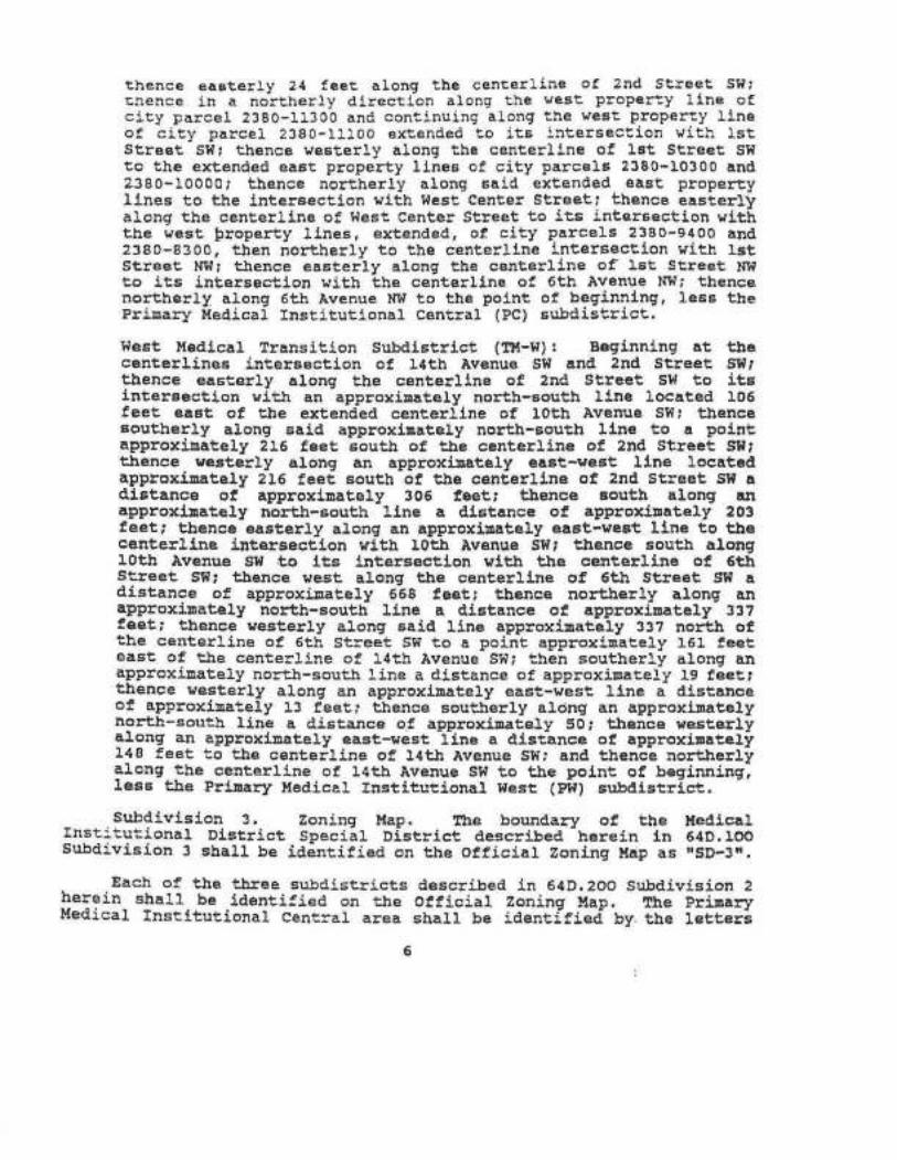
thence eaaterly 24 feet along the cEnterLine of 2nd St¡eet Slltcr¡ence in a no¡tberly directlon along the vest property llne ofclty parcel 2380-11300 and continuing along the west proPerty llneof, city parcel 2380-lL1oo extended to its intersection r¡ith IstStreet s¡{t thence westerly along the centerllne of lat Street SI{to the extended eaat property llnes of city parcele 2380-10300 and2380-10000, thence northerly along Eaid extended east propErsyllnes to tl¡e lntersectlon wlth West Center Streeti tl¡ence easterl)along the cent,erllna of l,lest Center Street to its intereeetion r¡ithtt¡e west, þroperty llnes, exÈended, of city parcels 2380-9400 and2380-8300, tben northerly to the centerllne lntersect,lon with tstStreet N
rrPC", tl¡e Priuary l{edicaL lnstitutlon¿1, West as'rPWr, and the l'ledicalTransltional areÃs as ,.tH-t{rr (west) and 'rTü-Eil (east) .
Sectlon 3 . Tl¡e Roctrester Code of Ordinancee is a¡sended by addinga Secclon to read¡
64D.3OO ¡ÍEDICÀL TNSTTTUTIONAL CÀ}TPUS SPECIÀL DIS'rRICÎ PI.ANNINGDOCU},ÍEMTÀTION
Sr¡bdlvision I. Planr¡ing DocuDents. Pe¡'uitted land use and zoningcontrols wltf¡ln tl¡e speCiaL district are based upon .the concept ofcampus-nide operatlons and lnter-relationshlps. Specifíc docunents areaaoþted by resoluÈ1on of, the Cot!¡oon Council aE palt of this specl.aldisÈrict wt¡icfr reflect this plannJ.ng eoncept. lhese docu¡ents will bethe speetf,ic gulde to Iand use withln the boundariee of tl¡e specialdlstricÈ. The specif,lc documents are descrlbed as follows:
(a) À Master Plan vnich shall describe a state¡¡ent of :nission andpur?oae, proposed land use areas, dlstriþutíon of and Daxiu¡¡¡caüPuÊ denslties, utllity infrastn¡etu¡e p1ans, and caupuslandscape and open spaêe plans and which shall descrLbe how thellaster PIan prorootes tl¡e purlrose of, tbe Rochester CornprehenEj-veplant
(b) À comprehensive transportatJ,on, parking, loading and materíalshand,ling syeteu and all veather pedestrian passage pJ.an, which¡
(1) demonstrates througlr engíneering sirnulatlons or eurrentoperationa a capaclty to adeguately sustaLn tbe existing andcontenplated developnent and not overly burden the pu.blicutiltty a¡rd transportation managenent syster,;
(2) deecrLbes long te¡:¡ plans for helicopter operati.ons,including the nature and intended use of heliçopter pada andsupport f,acilit,ies; site p3-ans for faeilities; projections oflevelE of aetivity ln te¡ms of flights per year; e$¡ipuent, andoperation stanôards; preferred f,Ìlght, approachaei andBanageaent plans for receiving and responding t,o couplaLnts;and
(3) ldentifies existlnE and planned programs to ueet parlcinEand transportation needs of, patients, staff, and enployees,epeeif,ieally ldentifying progra¡ls to encourage use of transit,carpoo1J.ng, blcycles, and other alternate tlÊans ofEranBpottatl.on.
(c) A catupus boundary descrlption vhfch identlfies the existingproPerty ownership of llayo Foundation wlthin tt¡eír canpus. It alsoincludes a sr:nnary of existing floor area within caropus area bybuilding and parcel.
7

Subd,ivision 2. Doct¡¡ents on !lle. ÀIL documents described in64D.3oo Sub I sl¡all be kept on fll.e r.rlth the City of Rochester in theoffice of the Rochester-Oinsted DeparcDent of Plannj.ng and llousing.
Sr¿bdivieion 3. Flve Year Plans Docnuent Updates. Wtthin tnononths of the adopt,ion of the Special Discrict and at least everY 5
)rears folloning tbè adoption the ltayo Foundatfon Ehal1 provide a writtenand graphic detall on the status of all planning docunents and theantlCipãted development in the follorinE flve year period. The ¡{ayoFoundat,lon shall ua)ce a presentatlon of plans to the Rochester Planningand Zoning CotrDission and the Rochester connon Council. lhe pur?ose oftlre plan updatea ehall be to inform Ëhe Clty of, proJects uhich uay havean inpact on capftal J.mproveuent prograrnming and lnfrasttl¡cture needs.Revisions to rnCster ptÀn doc¡¡¡ents wtft not norroally be triggered byf,lve year plan updatel, and w111 be consLdered at separate hearinge.
subdlvislon 4. zubllc Notlf,lcation nequÍrenents
(a) Flve yaar plan updatea referenced ln 64D.300 St¡bdlvlelon 3shall be offlcially adopted by the Counon council by reaoluttonafter revLew and rêconnendaÈlon by tlre clty Planning and ZoningConulssion and tt¡e Co¡n¡on Council. llhe Council shall approve thafive y€ar plan update unlese lt ¡nakas a f,lndinE that the update leÍnconsietent with the ¡naster planning docunents. Conslderatlon ottbe 5 year plans Eha1l be ¡¡ade In the f,oru of a publlc hearingbefore both tl¡e Roehester Planning and ZonlnE Counlssion and theRochester Comon Council wíth pr¡bttehed notice of the neetings 1nthe oflleÍal nêwspaper at least 10 days prJ.or to the neeting date.
(b) À¡end¡qentE to the planning docr¡nEnts on ffle raferenced ln64D.300 St¡bdivision 1 Sectj.on a and b shall not be accepted byresolution of ttre Cor¡mon Councíl r¡ntil the City Planning and ZoníngCon¡o,lseion and tbe Counon Couneil consider tlre proposecl a¡endedplans at publlc hearings. Notlce of, tl¡e lrearings to a¡end tl¡ereferenced plarurÍng docu:rents shal1 be made by prrblication ln theofflcial newspaper and sendinE of a ¡¡aLled not,lce to propertyowners withln the area subject, to the a¡endr¡ent and those r¡lthin350 feet of tlre perineter boundary of, the area subject to theamend¡ent.
Section {. flìe Rochester Code of ordinances is auended by aclôinga sec--ion to read:
64D.4OO IcRÀFFTC UITXGÀrIOtf SIUDTES REQUÍRED
Subd.ívi'6ion I: lraffåc Inpact Reports. For any neu parkingstrucEures or expansions to erlstlng parklng stnrctures, or nèw c'urb9u!s onto public streets frorn the Special District 3 Prinary Ile6tsubcistrict, Mayo FoundatÍon 1n coopération vith clty of Rocheeterlransportatj.on staff sha1l deteraine the need ior a Tralf1c lupact Studyprior to subu,ittal of a zoníng certif,icate appllcatlon. À fratflêInpact Study shall be prepared ánd sr¡b¡¡itted to -the cfty for revie¡r 1!
8.

it iE <ie¡e:nj.ned that the traffic aenerated by the fac.i.Llty lras t,hepotential to reduce the Level of Sen¡ice (LOS) on the adjacent streetat the åccess points to the faclllty or at nearby street intersections,assuraing current operat,ional configurations are naint,ainad. In thosecases where the resul-.ing IáS r'ill be a LÀS A or B, no study would bereguired. Current description and ¡nethod of conputation for Level. ofSe¡¡¡ice åE defined ln the Highway Capactty l.lanual shall be used as aguide.
The purpose of, the Trafflc lupaet Study ehall be to analyzeoperational irnpactE on traff ic fl.ov rvhich vehicles ut,llizing the parkingstructure will have. Tbe goal of suggested inprovenents shall be tomaintaln a Lave| of Senrice Ct unlees the existing LOS is beLow that,in which ca6e täe intent shall be to r¡aintain the exlsting Level ofSerr¡ice. If it is dete¡'uined that a study J.s needed, the extent of thestudy j.n ternE of affecÈed j,ntersectj.ons or street segruents to be lookedaÈ shall be dets::nined by clty statf , uslng as a guide the sÈandard thatany lnterEection wÌ¡ere ranp trafflc nay nake up Eore than 5t of the peakbour direcÈlonal trafflc is a candldate for Ëtudy.
_ Upon satisfacÈory conpletlon of the Traffic Iupaet Report aBdete¡¡ined by the Zoning ndninistration, it shall be uade availabLe f,orfevlev by the general pu.Ufic. À notice of availability of the reportfor inspection shall be published by the clty ln the locaL neuÊpapei ofrecord. CopÍes of the lraf,fic inpact report shall be made available f,ortnspectlon at tlre Otfice of, tlre Rocbester City Clerk, the RochesterPttbllc- Llbrary at the Off,ice of Planning and tlousinE. t¡lritten responseÊf,ron the Eeneral publlc concerrring the Sraff,ic lupact Report shall bernade to the ZonÍng Àd¡inistrator w-iÛrin 30 days f,ró¡n the p-ublication oftbe notíce of availability. Upon corapletión of tl¡e 3¡ day cou¡entperlod, all written resþonseJ recefved f,ro¡n the ptrbllc and arecoÌ'rh€ndaÈion lron the Zonlng Àdrninistrator concerninE the TratflcIDpact Report shall be f,orr¡ardCd to ttre Rochester connon councll. ThecoDDon CounciL uust by adopÈ1on of a resolution find the lraff,ic lrnpactReport and lts reco¡¡¡endád conclusions and rêcolnendatlons adequatebefore any aþinistrative branch of the city issue any penits neceésaryfor t'he parking structure, parl..ing struccule ercpansioñ or roadvay curËopenlnE.
subdlvisÍon 2t Traf fic lfonirorlng Inf o¡¡ation: the lrtayoFoundation sl¡aLl provide current, euplo¡rnent totals as of January fst ãf!þ" yeart to the-clty of Rochestef ufon reguest of the Deparinent ofPlanning and Housing, -bro]<en donn for dach Priuary Medical-hËtttutionallTea separately. The. purpose of this info::nation shaLl be t,o supply tbeclty of RochesÈer with thã basic lnfo¡nation needed to deternine-irrêtnerinitíatlon of a joint city-uayo t¡ed,ièal caupus TraffÍc study should, berecoE¡Dended to tbe Counon CouncÍI for the purpose of investi.gating theiupact of, additional enploynent tiowtrr vlthin ètre uayo Foundation oá thetrans¡rortatlon netwoçk åei'ing eách of the priraary udaicat-Instltutionalareas. llre staff w111 present to the Conmon Council a reconnendationon the need f,or a study; the Council shall decide whether to proceedwith the study and. stiall conduct discussions wltn ltayo ana- other
9

affectad propelty ouners on tbe distribution of costs andrespon6ibillties f,or coepLetion of the study.
It ie the fntent that such a study vould be consldered when thelrnpact of recent and near-ter:n futurè grorrth . results ln crltícElcapacity threshol.ds for the najor Etreet syÉteu eenrlng either of thepriuary- bedlcai-institutÍonal ãreas being approached, leadlng to theant,icipation of dlninistred and/or deterLorating transPortation senriceag additional growth occurs in tl¡e future.
Sect,lon 5. The Rochester Code of Ordlnances is auended by addlnga eeetLon to read:
Tbs ìfayo FoundatLon shall also provlde ân annual - report ofhellcopter oþeratlons, upon requeet ol tl¡e Departuent 9l Plannlng.andxousing, lncluding the total nunber of L¡ellcoptér take-offs and landlngeat, each hellpad, and the number of operatlons talclng place in daytÍae(7:00 À.1{. Co 10¡00 P.l'f.) and nigtrttlue t¡oure.
ffi S*:':r'.rsHsñ*içiffi P'}åFa) Ebe following prlnelpal land uEe6 are ,¡ré:nofËtìa .ä¿,9{r.fåø.[þ;tntbe Speclal Dlstrict 3 t{edical InEtitutlonal Ca:npus:
l. Eetabllsbments enEaged ln providlng ôlagmoatlc Éervlcae,extensl.ve ¡edl,cal treat¡¡ent (lncludfng aurElcal sernrfces) and otherhospltal se¡rrices, as uel1 as continuous nursíng señrice, includingEeneral uedlcal and surgical hospitals, specialty hospltalstaedlsal laboratories, outpatÍent cÀre facillties, aedLcal schoolsand aesociaÈed domitories, ¡edical appliance sales, and slnl-laruses, but not includinE ani¡al hospltals.2. Establlsh¡ents or other f,acllities for carrying oninvestigation in tÌ¡e natural or physical sciences, or engineèringand developnent as an extension of investigation r¡1tt¡ the obJecÈiveof creeÈing end produ::s, oD a contract or fee basis, and lncludlngpllot plant operation.
3. EstablLshnents priuarlly engaged in providJ.nE intermediate orl.ong tern nursJ.ng and health-relátéd care to individuals, t¡picallyclasEif,Led as nr:rsing houes.
4. Duelllngs providing shelÈer and services for tbe el.derly, wblc,haay.include ¡eals, houèekeeping, personal care assj.stance and ul.norneôicaL servlces, but noL inte¡¡eaiate, long te¡::l or extendednursLng care for residents. : -
5. Àutonobile parking lots and parlclng st¡rrcÈureo except thatparking lots and struðtures in thä üedltal InstltuÈional- ca¡lpuswest, subdistrict shall be intended to se:nre. uses located 1n ttrat
10

eubdist,ric)-, and not i.n the t{edlcla Lngt:tutional CentralSu-bdisrrict.
b) îhe folloving land uEe6 lrhich are incldental to the principaluse of the bulldlng are perntBted In tlre Special Dlstrict 3 l,ledicalInstitutional Canþus wlren within a build,ing lrousing a princlpleIand use described in 64D.5Oo Su.bd. Ia; and occupying less than 50percent of r-he total f loor area of the building.
offlces, esÈablislr¡¡ents prl:narlly engaged ln provid,J,ng ser¡/iceeinvolving the care of a pereon or his or her appare),, sucb as barbershops, clothing rental, reduct,ion salons and heaLth clube, photographicstudlos, cleaning and ga:roent se¡r¡ices (but not Íncluding povterlaundries or dt-y cleañing plants) or cofn-operatad laundriesiestabllsh¡rents fufníshlng eerrrlces incidental, to ttansportatlon, Euchaa freight forvarding, parlclng een¡ices, or the arranging of paasengeror freight transportatlont Reetaurants and cafeteriae
c) ÀcceEsory usea degcrlbed hereln are a pernltted use in theSpeciaJ. Dlstrict 3 ltedical Instltutlonal catrpus:
À bulLding, st¡n¡cture, or use whlch 1) 1g clearly fncidentalto and custo¡nar1Ìy tound 1n conjunction nlth a prineipal use,buJ-Iding, stnreture, or carrpua t 2) ls Er¡bordinate to andserves a principal use, bullding, st¡¡¡cture, or canpus; 3) lseubordinate j.n ãrea, extent or purpoae to the prl.ncipal use,building, st¡n¡cture, or canpus; 4) èontriþutes to the co¡fort,convenience, or is of neceslity to occupants of the principalbuilding, principal- use, or ca¡npuÊ. Wlthin the Prinary,lransltional, a¡¡d MedicaL lnstitutional West subdLstricts,açcesEorJ¡ pocer plants and.patklng fac{tftfes shall Eerve onlyttrose princípal. and incidental uses which are located ín thatst¡bdistrict.Subdivision 2. Campus Floor Àrea.
Î!¡e floor a¡ea ratio for the Special District Medical InEtitutionalCampus wilL be calculaied for each priuary Ca¡rpus subdistrict (Centra}or lfest) and lts adJacent lransitional subdistrict. llhe P.À.R. etÍlI becalculated by dividÍng tt¡e f,loor area of any Foundation owned buildingswlthin each priaary s-ubdÍEtrict and adjacent transltional subdistrlðtby the toial 1ot area owned by tlre Uayo Foundation vithin each priuarTst¡bdistrict and adJacent tranåltfonaL-dlstrict. The Maxi¡¡r¡¡ F.Á.R foithe Priuary Dledlcal, Inst,itution Central sr¡bdistrict and adJacent MedicaltransitÍonal Àrea sbalL be 6.0. The uaxinr¡¡ r.À.R. toi the pr5.uaryMedlcal InEtitutional West sr¡bdistrict and adjacent UedlealTransitional Sr¡bdistrict shall be 4.0.
St¡bdlvision 3. SeÈbaeks - Bu:f er:fards - Lot Coverage
a) There slrall be no requlred setbacks or yards Ín the SpeclalDistrict Prinary Med,ical fnstitutionat carnpui Sr:bd,lstricts äxcept
11

where the Special Dis'-rict Carnpus adjoins a properay vith anunderf ying ór existing resident,ial zoning dist,rict t¿ithout ¡incen¡èniñg street, alley or Peroanent. public oPen space and vherethe lot separated by the discrj.ct boundary have adj.acent' fronsyards. In -t|¡is case, the first 1OO feet of the Special Dlstrictöaupus lot adjacent to the residence dietrict ehal1 provide !tfroirryard or sidestreet sideyard adJacent to tbe residence districtof Ëhl rnininun depth reguiied for a frontyard in tbe reEidencedietrict. Such yatd shall be landscaped except f9T the necessarydrives and r.¡allcwãys and shall not be used f or parking.
b) À- perimeter bufferyard or eetback sþall be- reErired along Èheexteriôr property ti¡eá of each Speclal Dlstrict çauPg? vhere ÈheSpecial oietitct'boundary abuts a residential zonlng dletricÈ notwitl¡in the Special District boundary. Tbe peri¡neter bufferyard orsetback width al.ong a street shall be 33 feet fron the proPertyLlne. The peri:netãr bufferyard or setbac)< along property llnesthat, are noC along a s¡reet-shall bE 16r fro¡ tÌre property line.
c) Wl¡ere a Prinary Medical Institutional Canpus St¡bdistrictdlrectly abuts or ls- separated by a public street or aLley f,ro¡proPerty uitlr RI or R-2 zoning a t5 | buf feryard or setÞack ltonany ca¡Dpus suþdlstrict property llne is rêguired for stn¡cturee35r or less ln treight above tbe average natural.grada along tlrecomnon lot llne. for stn¡ctures over 35r in heigbt the setbackfrom the co¡¡mon lot line shall be 33 | .
d) In the Medlcat Transitional sr¡bdietrict, a buff,eryard orsetback of gr ueasured from tlre property llne shall be providedalonE all Etreet property llnes except rbere the street faces orf,ronts a Prinary Medical InstiÈutional Subdistrict boundary.
e) In the I'ledical transiËional subdistrict all stn¡ctures erectedon a lot which contains less than an entire block f=ont shall besetback from side and rear property lines the r¡ini¡¡r¡m setbacksfound in the adjacent underlying zone. Where t,he l{eðicallransitÍonal Subd,istrict lot ðlrectly adjoins and has adJacentfrontyards wlth a 1ot with underlying or existing residentialzoning, tåe first loo feet of, ttre Uedieal Transition subdlstrlctlot shall provide a frontyard adjacent to the residence dlstrictof the ¡qini¡¡r¡¡l depth required for a f,rontyard in the residencedistrict.f) In Hedical lransitionaL sr¡bdtstricts open parking arêas (lots)reguire no speciflc buf,f,eryard r¡ldth or setbaclc exeept that allparking s¡races ¡oust þe screened by r.raLls, fences, berns and/orlandscape plantings Èo a height of at ieast 40 inchas. If, tl¡eunderlying zoning of the property to be used for a parking lotst¡r¡cture in the lfedical Transitional S¡¡bdistrict is R-t or R-2then the site on v¡hich the parking use is to be located uust haveat 1east 200' of lot r¡idth as üeasured along the street frontage.
L2

E) Traffic Vtsiþlllty Corner Lots. In the Medical'InstitutionaLcarnpue Special District no traffic visibil"ity zone sball beregirired as found in 62.202 of the Zoning Code on corner Jots whentbe intersecting Etreetg creaÈing the coû¡er are controlled Þystoplights (seuaphores)
h) Subdivision 3. l{axi¡¡um lot eoverage of all st¡r¡ctures in thetriuary Medical. LnstiÈurional f{es-- Subdistrict shal1 be 50 PercenÈ.
Sui¡division ¿. lleiEht Llnlte.a) lhere shall be no ¡naxluun helght for princlpal. or accessorybulldlng otr Etrnrctures in tlre Special Dlstrict Prf¡ûary lledicalInstítuiional Central St¡bdistrict. In the Prinary lfedícaIInÉt,itutional - l{est Sr¡bdlstrlct the uaxirnun height for princlpalor accesaor1l bulldlngs shaII be 2Lo feet and f,or parlcing raups thenaximuu height shall be 66 feet aE ¡easured to the toP of theupPernost parklng floor of the parking strr¡cture.
b) lhe maxinuu height for buildings or Etrr¡csures in the SpecialDiEtrict TransttionàI Medical canpus Sr¡bdistrlct wlll be 66r. Theheight reguireuent f,or.this eection ie ealcufated as follows: 33feet abové grade J.evel ie peruitted and additional building heíghtis allowed Þy adding one foot lncrenents for eac!¡ one foot ofadd,itional eetback above 33t fron the periueter sÈreet llne of theSpecial DlstrLct.subd,lvislon 5. sÍgns
Sigms wlthin ttre Special Dl.strj.cÈ Prinary l.fedlcal sr¡bd.istrictssha1l bê controlled, as regulated by t!¡e stanåards of the RocbeeÈerZoning Code in tbe.f (Institutlonal)-Zoning DiEtrict. Sigms in theTransltional Medical Suþdistrict shall be regrulated by Èhe standards ofthe Rochester Zoning Code as applied to the respective underlying zone.
Su̡division 6. parking and Load,ing
lhe nu¡ber cf off-street parklnE and loading spaces regrrired forany neh, building oçansion in the Special District liledical InEtitutionalCa¡npus shaLl be det,e:rnined by the goals and standards of the CampusMaster PLan.
Oft etreet par)<ing goals shall be deta¡nined for each prirnarysubdistrict and lÈ,e surr-ounaing transitional subd,istriet. I partclng anåloadina plan for the Priuary ltedical Dlstrict f{eet anã adJácentTransitionaf Þfedical Àrea and- for the Priroara Medical InetltutionalCentral and adJacent Transitional ùleôlcal Àrea-w111 be provided.
Sr¡.bdivision 7. Bours of operation
13

Àny peraitt,ed use within the Special. Disrrlc-- ltedical Institutionalcanpus tträt is involved vith continuous prinary :nedical care, provisionof emergency nedical attention, nedical research, laÞoratory analysisor integral- aduinietration of such activit,ies aay tdce place at any --j.Eeduring the day or night,.
St¡bdivision 8. Helipad - Helicopter Àccessory Use
Helicopter access must be used for energency transportatíon only.ÀI1 helfpads nust be located within the prinary Medlcal InstitutionalSubdistrict boundariee. fhe Priuary Instltutional t{Est Sttbdistrictst¡all have only one priuary functioning helipad, however, back-up orsecondary trelipads nay exist, r¿ithin the s¡¡bdlstrict. Helipads ¡!u6t belocated as shown ln adopted naster plan documents.
Section 6. trt¡e Rochester Code of Ordinances is aaended by addlnga sectlon to read:
64D. 5OO PERUIÎ AD!.ÍIITSTRÀTION
In additlon to the reguireuents of 61,2Oo of the ZonÍng Code, everyapplfcation for a zoning cert,if,icate withln the lledlcal Inetltutionalca¡ûpuÊ shall be acconpanied by a couplete and up-Uo-daÈe docu¡ent whlshdescribes the existing nr¡nber of, pàrklng Ëpaces avallaþLe vtthin tl¡e!Íedícal lnstitutíonal Campus Uy sufaistrict, Èhe total anount of f,1oorarea withln the campus by er¡bdistricÈ and'the total lot area wl,thln theCaupus by subdlstrict.
In order to issue a zoning certificate sitnln the lledicalInstltuÈLonal campus, the Zoning Àd¡iniEtrator must dete¡aine if alldevelopment standards are net and tl¡e proposed use ot, buildings orstnrctures ie consistent, wlth the Special District docunents. llhezoning ad¡inistrator shalL act upon all appllcations for zoninEcertifLcate and condit,ional use pe::aits on vhlch he is autlrorized to aeÈby thg,provisions of the zoning êode wi¡-hin thirty'(30) days after theyare flled ln full compliance witt¡ aII the applicãble requitrersents. Heshall either issue tlie peraits wittrin saið thircy (30) days or shallnotify the applicant in-wríting of his refusal and reasoni therefore.
Section 7. lhe Rochest,er Code of Ordinances is amended by addlnga section to read:
64D.7OO VâRI.A¡.¡CE À¡ID ÀPPEAI,S
lhe Rochester Co¡onon CounciL shal,I be designated as ttre ZoningBoard of Àppeals and assune the dut,ies of the Boaid to hear and decldèappeals of any deeision uade by the Zoning Àd¡uinistrator in theadministratÍon and enforceaent of ttrls speeial dlstrict and hearleguests for variances from the literal provisions of this specialdi.strict.
14

Section 8. The Rochoster Coda of ordlnances ia amended by addlnga sectisn to read:
64D. 8OO RESCINDTNG ÀPPROVÀL
The Rochester con¡on councll Eayprovlsione of, this Special Dlstrlct andunderlylng zoning district at the tÍueoverlay zoning district eha1l follow tt¡e51.500 of the Rochester Zonlng Code.
wlthout liabillty rescind t!¡ereturn tlre propert,ies to theirof adoption. Rescinding thLsproeedures eet, fo¡Èh ln SeeÈion
Sectlon 9. Thie ordj.nance shalL be effectlve fror¡ and after ltspubllcatlon,
PÀSSED À¡.TD ÀDOPTED BY rlIE COUMON COI'NCTL OF THE C¡llY OF
ROCBESTSR, UTNNESOTÀ, rHIS /K DÀY OF , 1991.
g SeiD(
ÀTTEST:
ÀPPRO\¡ED T¡TIS
(SeaI of t!¡e City ofRochester, I{lnnesota)
J2 DÀY OF , lggl.
15

oRDtNANcE No. Sdaq
AN ORDINANCE AMENDING AND REENACTING SUBDIVISION 2OF SECTION 64D.2OO OF THE ROCHESTER CODE OFORDINANCES, RELATING TO THE LEGAL DESCRIPTION FORTHE L.AND COVERED BY THE MAYO CLINIC MEDICALINSTITUTIONAL CAMPUS SPECIAL DISTRICT #3.
THE COMMON COUNCIL OF THE CITY OF ROCHESTER DO ORDAIN.
Section 1. Subdívision 2 of Section 64D.200 of the Rochester Code of Ordinances ishereby amended and reenacted to read as follows:
Subdivision 2. Special District Medical lnstitutional Campus Sub-Districts.The regulations established hereinafter for this special district will be uniquelyapplied in defined Subdistricts withín the boundaries of the Special District. Thespecial district will be divided into the following subdistrict areas:
3) Special District 3 - Medical Transition Area lying adjacent to the two PrimaryMedical lnstítutional Subdístricts. These subdistricts are legally desøíbed asfollows:
East Medical Transition Subdistrict (MT-E): Beginning at the centerlineintersection of 6th Avenue NW and the south rightof-way line of 5th Sfeet NWand proceeding southeasterly along said south right-of-way and the southright-of-way for the extension of Sth Street NW as indicated on Offrcial Map No. l1(City Ord 2542) to its cenlerline intersection with 2nd Avenue NW; thence southafong the centerline of 2nd Avenue NW approximately 54 feet to the center line ofthe right-of-way of the former Chicago and Northwestern Railroad Spur line;thence southeasterly along said railroad right-of-way centerline to the centerline oflst Avenue NW; thence south along the centerline of lst Avenue NW to ¡'ts
intersectron with the centerline of 3rd Street NW, thence west along the centerlineof 3rd Street NW to its íntersection with the centerline of 2nd Avenug NW; thencesoutherly along the centerline of 2nd Avenue NW to its centerline intersection with2nd Street NW; thence easterly along the centerlne of 2nd Street NW to themidblock line between 1st Avenue NW and North Broadwayi thence southerlyalong said midblock line between 1st Avenue NW and North Broadway to itscenterline intersection with lst Street NW; thence westerly to the centerline of 1stAvenue NW; thence southerly along the centerline of 1st Avenue NW to itsintersection w¡th Center Street; thence westerly to the mid-block lot line betweenlst Avenue SW and 2nd Avenue SW; thence southerly along said mid-block lotline extended to its centerlíne intersection with 3'd Street SW; thence westerlyalong the centerline of 3rc Street SW to its centertine intersection with 2nc AvenueSW; thence southerly along the centerline of 2nd Avenue SW- to its interseclionwith 6th Street SW; tírence-westerly along the centerline of 6th Street SW to itscenterline intersection with 5rn Avenue SW; thence northerly along the centerlineof Sth Avenue SW to the mid block line between 5th Street SW and 4th Street

SW thence westerly along saíd midblock líne behtreen Sth Street SW and 4thStreet SW to its intersection lvith 6th Avenue SW; thence nor-therly along thecenlerline of 6th Avenue NW to its íntersection with the centerltne of 4th StreetSW, thence westerly alcng the centerline of 4th Streel SW to its intersection withthe west property line of cily parcel 1600-15000; thence northerly along saídwest property line of cíty parcel 1600-15000 to the centerline of the alleybetween 4th Street SW and 3rd Street SW; thence easterly along the centerlineof said alley to the centerline of the alley west of city pârcels 1600-14700 to1600-14835; thence northerly along the centerline of said alley to its extendedintersection with the centerline of 3rd Street SW; thence westerly along thecenterlíne of 3rd Street SW to its intersection with the centerline of 7th AvenueSW; thence northerly along the centerline of 7th Avenue SW; thence easterly 24feet along the centerline of 2nd Street SW; thence ín a northerly direction alongthe west property line of city parcel 2380-11300 and continuing along the westproperty fine of city parcel 2380-1 1100 extended to íts intersection wÍth 1st StreetSW; thence westerly along the centerline of 1st Street SW tothe extended eastproperty lines of city parcels 2380-10300 and 2380-10000; thence northerlyalong said extended east property lines to the lntersection with West CenterStreet; thence easterly along the centerline of West Center Street to itsintersection with the west property línes, extended, of city parcels 2380-9400 and2380-8300, then norlherly to the centerline íntersection with lst Street NW;thence easterly along the centerline of lst Street NW to its interseciion with thecenterline of 6th Avenue NW; thence northerly along 6th Avenue NW to the pointof beginning. less the Primary Medical lnstitutional Central (PC) subdistrict.
Sectíon 2. This ordinance shall be effective from and after the datè of its publication,
PASSED AND ADOPTED BY THE COMMON COUNCIL OF THE CIW OF
ROCHESTER, MINNESOTA, THIS DAY OF 2004.
COMMON ctL
ArrESr: /-øtø-/þft/"JO éIf( CLERK
APPROVED THIS 21.?r DAY OF Mmêú4- _. ,2004.
/û-e4MAYOR OF SAID
(Seal of the City ofRochester, Minnesota)
2
Or42tc0r6¿D 20C(tt


PART 10.0 | APPENDICES:
November 2, 2016
MAYO SUPPORT CAMPUS SPECIAL DISTRICT: Zoning Ordinance #3534 (2003)

oRDINANcÉ ¡to ffi4AN ORDINANCE CREATING AND ENACTING CHAPTER 64N,
AND AMENDING AND REENACTING SECTION 60.327 OF THEROCHESTER CODE OF ORDINANCES, RELATING TO ÏHEESTABLISHMENT OF THE MAYO SUPPORT CAMPUS SPECIALDISTRICT.
THE COMMON COUNCIL OF THE CITY OF ROCHESTER DO ORDAIN:
Section 1. Chapter 64N of the Rochester Code of Ordinances is herebycreated and enacted to read as follows:
64N. MAYO SUPPORT CAMPUS SPECIAL DISTRICT
64N.1OO FINDINGS AND DISTRICT BOUNDARIES
Subdivision 1. Fitdings. lt is the finding of the Council that the lands describedin Subdivision 3 herein which define the property under the ownership and control of theMayo Clinic are of special and substantial significance to the City of Rochester. ln adesire to effectively and efficiently achieve community goals, to assist and encouragethe development and expansion of medical support land uses, to comprehensivelymaster plan a phased medical campus, to integrate related medicalfacilities on a singlecampus, with skillful architectural and landscape design, and to efficiently plan for futureprivate investment and public capital, the Common Council hereby creates a specialzoning district, as provided in Section 62.900 of the Rochester Code of Ordinances(R.C.O.), to be known as the Mayo Support Carnpus Special District. Thisdetermination is based upon the following specific findings:
A. The land area, the existing land use and existing facility at the MayoSupport Campus provides the opportunity to expand the medical serviceson a single campus site and to integrate related medical services in anefficient manner.
The'land area under the ownership of the Mayo Clinic provídes adequatespace to buffer neighbors from potential adverse impacts of noise, visual,traffic, and congestion.
The,structures and activities on the site are proposed to be confined to anarea removed from the boundaries of the site. The physical configurations ofand interrelations among the structures and activities are not anticipated toadversely impact adjacent property owners.
B
c

D. Given the unique nature of the Mayo Support Campus operations and thesize and arrangement of its site, it is desirable to devise a unique zoningdistrict with specific regulations that will accommodate the needs of the
medical campus and adequately guide the expansion of its activities and
facilities. ln doing so, it will perinit the Mayo Clinic to confidently plan forfuture investment and growth in Rochester at a site that is remote from thedowntown campus. Similarly, the City will be able to confidently program
its long-range capítal investment in the area based on agreed-upon plans.
Subd, 2. lntent. lt is the intent of this Ordinance to assist and encourage thedevelopment of the medical related support services and activities in a campus settingby creating special zoning approaches. All of the structures and uses of the land areintended, directly or indirectly, to further the purpose of integrating medical supportservices on a single campus with adequate space for future growth.
A. Uses of land and structures related to medical and clinical support servicesincluding the following :
(1) Clinical and Administrative Support Services
(a) Facility eng¡neer¡ng(b) Hurnan Resources(c) Adrninistrative Services(d) MedicalRecords(e) Data Processing(f) Laboratory/Laboratory Support
(2) Medical
(a) CommunityMedicalPractice(b) Research, Development and Testing
Uses of land and structures for light manufacturing, including, but notlimited to, printing of brochures, software production, computerenhancement, and technology research and development.
Uses of land and structures for officês, warehousing and storage, park andride facilities, parking structures, maintenance and vehicular storagegarage and utility support facilities.
Uses of land and structures f<¡r communication and emergency services,exercise facilities and educational services, cafeteria, day-care facility(employee), and other similar or related uses.
Pedestrian and bicycle facilities and trails with connection to the DouglasTrail system and other similar amenities for use by employees.
2
B
c
D
E.

F. Storm water detention and relatetd facilities'
These zoning approaches are applicable to institutions, which have ownership of the
lands described below.
Subd. 3. Descriptþn cf Lands C.ontairlgd-Herein. This Ordinance shall qpply tothe foltowing lanãGted ir, th-Õitt ôf ftochester, County of Olmsted, State ofMinnesota:
Lots 1 ,2 and 3, Block 1, Western Digital Technology Park, Olmsted County,Rochester, Minnesota
64N.200. EFFECT OF REGULAIIONS.
Subdivision 1. Ap¡¡llçErbllity. The Special District established by this Ordinanceshall be an overlay zoning district with unique development standards and proceduresapplicable to development on the property defined as the Mayo Support Campus, whichis the property within the district boundary. Unless otherwise specified within theseregulations, all other standaiils and requirements of the Rochester Zoning Ordínanceremain in effect. All uses in the Mayo Support Campus Special District are considerednonresidential uses.
Subd. 2. Zonllo Mao. The boundary of the Mayo Support Campus SpecialDistrict shallbe identified on the officialZoning Map as'SD-13."
64N.300. MAYO SUPPORT CAMPUS SPECIAL DISTRICT PLANNINGDOCUMENTATION.
Subdivision 1. Planning Do.cumentq. Permitted land uses and zoning controlswithin the special district are based upon the concept of site-wide operations and inter-relationships. Specific documents are adopted by resolutions of the Common Councilas part of this special district, which reflect this planning concept. These documents willbe the specific guide to land uses and phased activities within the boundary of thespecial district. The specific documents are described as follows:
A. A long-range Master Plan (General Development Plan), which shallinclude a narrative of intended uses, general site capacity, structures,proposed land use activities, general locations and separation distancesfor structures, areas for parking and accesses, provisions for pedestrianand bicycle facilities, and open space.
A Traffic lmpact Report with an analysis of existing conditions ánd fullbuild-out at the proposed campus.
3
B

Subd. 2. Approval and Amendment Processes. The Master Plan and Traffic
lmpact Report, and any amendments therek¡, shall be processed under the provisions
and criteria of the Zoñing Ordinance and t-and Development Manual for the City of
Rochester. Both thã initiál approval and subsequent amendment of the Master Plan
shall be processed according to the Type lll, Phase ll process.
Subd. 3. plan Document Updates. Every five years following the adoption of
the Mayo Support Campus Special District, but synchronized with the downtown
Medicai Campus review periods, the status of all planning documents shall be reviewed.
The Mayo Cliiric shall make a presentation of plans to the.Rochester Planning and
Zoning ôommission and the Rochester Common Council beginning in-2006. Each
prur"ñt"tion shall be in the form of a public hearing with a minimum of ten days notice
gíven ín the offícialnewspaper.
64N.400. SPFCIAL DISTRICT DEVELOPMENT STANDARDS.
Subdivision 1. Lermitted Land Uses. The principal land uses as described inSection 64N.100, Subdivision 2 (A-F), and other similar or related uses, are permitted
as of right in the Mayo Campus Speclal District.
Subd. 2. F¡oorArea. Lot Coverage. Setbacks. Buffervards. and Height and.Bulkof Structures,
A. The floor area ratio for the Mayo Support Campus Special District shall notexceed 0.50.
The proportion of impervious surface created by structures and paved
areas shall not exceed 60% of the gross area.
Except as provided below, the setback along any property line may be
used for pedestrian ways, bikeways, landscaping, and drainage, but not forparking. Existing slructures and parking areas located within requiredsetbacks are permitted to remain.
A setback of 100 feet from the right-of-way line of the Douglas Trail shallbe nequired along the exterior property line of the Special District Campuswhere the Special District boundary adjoins the Douglas Trail, which shallbe used only for pedestrian ways, bikeways, landscaping and drainagefacilities.
Except for pedestrian ways, bikeways and drainage facilities, the setbackarea shall be maintained in vegetative cover, which may include the usesin Subdivision 3 (B).
B
c.
D
4

E. Parking structures shall not exceed four levels of exposed parking or.50feet in height on the east side of the property. Where a fourth level ofexposed pãrking is proposed, the fourth level shall not have a roof above
the parking spaces. Other structures, regardless of their distance from the
east property line, shall not exceed five exposed levels or 75 feet in heighton the east side of the ProPertY.
F. Lighting for this property shall comply with Lighting Standard B of theRochester Zoning Ordinance and Land Development Manual and shall becuþoff light fixtures satisfying R.C.O. 563.213(3).
G. Site design shall be developed to minimize impacts to the adjacentneþhborhood, especially from tnechanical units, exterior lighting, parkinglot and ramp lighting, and noise.
H. ln order to maintain the existing¡ quality and usability of the Douglas Trail,storm water management shall be designed such that surface water runoffwill not exceed baseline conditions documented prior to fudher sitedevelopment with respect to the Douglas Trail right-of-way. Additionally, aseparation from the Douglas Trail right-of-way to the storm water facilitiesshall be provided to allow maintenance, repa¡r and reconstruction of saldfacilities to avoid disturbance to the land within the Douglas Trail right-of-way.
To soften the edge of the Campus where it meets the Douglas Trail right-of-way, a bufferyard shall be provided along the entire north and eastproperty line that is comparable to Bufferyard "8," as identified in R.C.O.s63.265.
Subd.3. Landscaoinq.
All new surface parking spaces and drives located within the requiredsetback areas shall be by berms and/or landscape plantings. Outside ofsetback areas, surface parking landscaping shall be provided at a levelsimilar to existing parking lot landscaping.
All setback areas shall be landscaped in accordance with the landscapeplan element of the Site Development Plan for each phase. Landscapingof setback areas may include forestry, cropland, pasture, and/or prairiegrasses in place of or in addition to conventional landscaping materials.Notwithstanding any other ordinance to the contrary, the Mayo SupportCampus Special District is exempt from limits on the height of native orornamentaltall grasses, native or omamentalforbs and shrubs.
A.
B
5
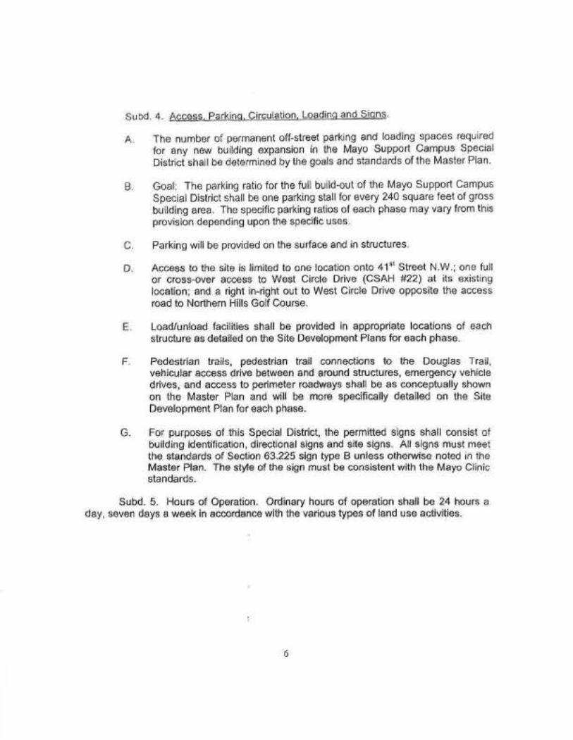
Subd. 4. Access. Parkino. Circulation. Loadino And Sions'
A. The number of permanent off-street parking and loading spaces required
for any new building expansion in the Mayo Support Campus Special
Districi shall be determined by the goals and standards of the Master Plan.
Goal: The parking ratio for the full build-out of the Mayo Support Campus
Special District shall be one parking stallfor every 240 square feet of gross
building area. The specific parking ratios of each phase may vary from thisprovision depending upon the specific uses.
Parking will be provided on the surface and in structures.
Access to the site is limited to one location onto 41"t Street N.W.; one fullor cross-over access to West Circle Drive (CSAH #22| at its existinglocation; and a right in-right out to West Circle Drive opposite the accessroad to Northern Hills Golf Cource.
Load/unload facilities shall be provided in appropriate locations of eachstructure as detailed on the Site Development Plans for each phase.
Pedestrian trails, pedestrian trail connections to the Douglas Trail,vehicular access drive between and around structures, emergency vehicledrives, and access to perimeter roadways shall be as conceptually shownon the Master Plan and will be more specifically detailed on the SiteDevelopment Plan for each phase.
For purposes of this Special District, the permitted signs shall consist ofbuilding identification, directionalsigns and site signs. All signs must meetthe standards of Section 63.225 sign type B unless othenøise noted in theMaster Plan. The stle of the sign must þe consistent with the Mayo Clinicstandards.
Subd. 5. Hours of Operation. Ordinary hours of operation shall be 24 hours aday, seven days a week in accordance with the various types of land use activities.
B
C
D
E
F
G
6

64N.S00. PERMIT ADMINISTRA'I'ION. Subdivision 1. ln addition to therequirements of R.C.O. 5$61.580 through 61.584, every application for a zoningcertificate within the Mayo Support Campus shall be accompanied by a complete andcurrent document which describes the exÍsting number of parking spaces availablewithin the Special District and which certífies that the cumulative total of land uses andstructures, including those for which the zoning certificate is sought, do not exceedSpecial District standards for floor area and impervious surface coverage.
Subd. 2. ln order to issue a zoníng certificate within the Mayo Support Campus,the zoning administrator must determine if all development standards are met and theproposed use of buildings or structure is consistent with the Special District documents.
64N.600. VARIANCE AND APPEALS. The Rochester Common Council isdesignated as the Zoning Board of Appeals and will assume the duties of that Board tohear and decide appeals of any decision made by the zoning administrator in theadministration and enforcement of thís Special District and hear reguests for variancesfrom the literal provisions of this Special District.
64N.700 RESCINDING APPROVAL. The Rochester Common Council may,without liability, rescind the provisions of this Special District Ordinance and return theproperty to its underlying zoning district at the time of adoptíon or to another zoningdistrict. Rescinding this overlay zoning district must follow the procedures set forth inR.C.O. 560.330.
Section 2. Section 60.327 of the Rochester Code of Ordinance is amended andreenacted to read as follows:
60.327 SD SPECIAL DISTRICTS: Existing Special Districtsapproved by Ordinance numbers 3443, 3404, 2726, 2516,2247, 3385, 3468, 3497, 3503, 3520 and 3534 arerecognized as separate zoning districts and the plans andprocedures established for each Speclal District will continuein force. When a $pecial District Ordinance does not specifythe procedure or criteria to amend an approved sitedevelopment plan, the proposed amendment will bereviewed under Section 64.148. When a Special DistrictOrdinance requires a two-phase review, thê developrnentwill be reviewed under Section 61.146 and either Section62.708 (1) (for preliminary plans) or Section 62.708 (2) (forfinal plans).
7

Section 3. This Ordinance shall become effective on and after the date of itsPublication.
PASSED AND ADOPTED BY THE COMMON COUNCIL OF THE CITY OF
ROCHESTER, MINNESOTA, THIS 22 DAY OF tfihultk// 2003.
OF SAI COMMON COUNCIL
ATTEST:
(Seal of the City ofRochester, Minnosota)
(
c - ît('r,/CITY CT.ÉRK
APPROVEDTH|SzÔ DAYoF( a {- ,2003.
^fa.¿***,4¿na*-MAYCIR OF SAID CITY
I