ROBERTS GEORGE R TR (PLN040662) - Monterey …€¦ · · 2013-11-21ROBERTS GEORGE R TR ... (531...
33
PLANNING COMMISSION COUNTY OF MONTEREY, STATE OF CALIFORNIA RESOLUTION NO. 05026 APN# 008-472-004-000 FINDINGS & DECISION In the matter of the application of ROBERTS GEORGE R TR (PLN040662) Combined Development Permit consisting of: Coastal Administrative Permit to replace a 7,565 square foot, 2- story residence destroyed by fire (PLN010225/Abdullah) with a new 14,182 square foot 2-story single family residence including patio (336 square feet), detached mechanical room (531 square feet), electrical transformer vault, 6-foot tall front perimeter fence (2-inch dark oil rubbed bronze bar stock with 6-inch square openings), and planter walls; Coastal Development Permit for a separate two-story structure consisting of a caretaker's unit (850 square feet) above a mechanical room/laundry/storage (850 square feet) and attached 1-car carport; Coastal Development Permit to remove five (5) Monterey pine trees, relocate two (2) Monterey cypress trees, and trim one (1) Monterey cypress tree in addition to after-the fact approval to remove and trim approximately 47 Monterey pine and cypress trees following January 2005 storms; Coastal Development Permit for development within 100-feet of environmentally sensitive habitat area (ESHA); Coastal Development Permit for development within 750-feet of archaeological resources; and Design Approval. The project is located at 3212 Seventeen Mile Drive, Pebble Beach, Coastal Zone. The project came on regularly for hearing before the Planning Commission on June 29, 2005. WHEREAS: Said Planning Commission, having considered the application and the evidence presented relating thereto; FINDINGS OF FACT 1. FINDING – PROCESS : The subject Combined Development Permit (PLN040662/Roberts) has been processed in accordance with all applicable requirements. EVIDENCE: (a) On November 15, 2004, an application was filed on the behalf of Mr. George Roberts, owner. The application consisted of requesting a Coastal Administrative Permit to develop a caretaker unit on a legal lot of record that has a positive archeological site. (b) On February 8, 2005 the application was amended to include a new single family residence. Based on new information, the project description changed to a Combined Development Permit with the following entitlements: - Coastal Administrative Permit to replace a 9,323 square foot, 2-story residence destroyed by fire (PLN010225/Abdullah) with a new 14,182 square foot 2-story single family residence including patio (336 square feet), detached mechanical room (531 square feet), electrical transformer vault, 6-foot tall front perimeter fence (2-inch dark oil rubbed bronze bar stock with 6-inch square openings), grading and planter walls; - Coastal Development Permit for a separate two-story structure consisting of a caretaker's unit (850 square feet) above a mechanical room/laundry/storage (850 square feet), and attached 1-car carport; - Coastal Development Permit to remove five (5) Monterey pine trees, relocate two (2) Monterey cypress trees, and trim one (1) Monterey cypress tree in addition to after-the
Transcript of ROBERTS GEORGE R TR (PLN040662) - Monterey …€¦ · · 2013-11-21ROBERTS GEORGE R TR ... (531...

PLANNING COMMISSION COUNTY OF MONTEREY, STATE OF CALIFORNIA
RESOLUTION NO. 05026
APN# 008-472-004-000
FINDINGS & DECISION In the matter of the application of ROBERTS GEORGE R TR (PLN040662) Combined Development Permit consisting of: Coastal Administrative Permit to replace a 7,565 square foot, 2-story residence destroyed by fire (PLN010225/Abdullah) with a new 14,182 square foot 2-story single family residence including patio (336 square feet), detached mechanical room (531 square feet), electrical transformer vault, 6-foot tall front perimeter fence (2-inch dark oil rubbed bronze bar stock with 6-inch square openings), and planter walls; Coastal Development Permit for a separate two-story structure consisting of a caretaker's unit (850 square feet) above a mechanical room/laundry/storage (850 square feet) and attached 1-car carport; Coastal Development Permit to remove five (5) Monterey pine trees, relocate two (2) Monterey cypress trees, and trim one (1) Monterey cypress tree in addition to after-the fact approval to remove and trim approximately 47 Monterey pine and cypress trees following January 2005 storms; Coastal Development Permit for development within 100-feet of environmentally sensitive habitat area (ESHA); Coastal Development Permit for development within 750-feet of archaeological resources; and Design Approval. The project is located at 3212 Seventeen Mile Drive, Pebble Beach, Coastal Zone. The project came on regularly for hearing before the Planning Commission on June 29, 2005. WHEREAS: Said Planning Commission, having considered the application and the evidence presented relating thereto;
FINDINGS OF FACT 1. FINDING – PROCESS: The subject Combined Development Permit (PLN040662/Roberts) has been
processed in accordance with all applicable requirements. EVIDENCE:
(a) On November 15, 2004, an application was filed on the behalf of Mr. George Roberts, owner. The application consisted of requesting a Coastal Administrative Permit to develop a caretaker unit on a legal lot of record that has a positive archeological site.
(b) On February 8, 2005 the application was amended to include a new single family residence. Based on new information, the project description changed to a Combined Development Permit with the following entitlements: - Coastal Administrative Permit to replace a 9,323 square foot, 2-story residence destroyed
by fire (PLN010225/Abdullah) with a new 14,182 square foot 2-story single family residence including patio (336 square feet), detached mechanical room (531 square feet), electrical transformer vault, 6-foot tall front perimeter fence (2-inch dark oil rubbed bronze bar stock with 6-inch square openings), grading and planter walls;
- Coastal Development Permit for a separate two-story structure consisting of a caretaker's unit (850 square feet) above a mechanical room/laundry/storage (850 square feet), and attached 1-car carport;
- Coastal Development Permit to remove five (5) Monterey pine trees, relocate two (2) Monterey cypress trees, and trim one (1) Monterey cypress tree in addition to after-the

RESpc_05026.doc Page 2 of 33
fact approval to remove and trim approximately 47 Monterey pine and cypress trees following January 2005 storms;
- Coastal Development Permit for development within 100-feet of environmentally sensitive habitat area (ESHA);
- Coastal Development Permit for development within 750-feet of archaeological resources; and
- Design Approval. This application was deemed complete on March 4, 2005.
(c) Location. The project site is located at 3212 Seventeen Mile Drive, Pebble Beach (Assessor’s Parcel Number 008-472-004-000), Del Monte Forest, Monterey County (the “Property”).
(d) LUAC. On December 2, 2004, the Del Monte Forest Land Use Advisory Committee considered plans for a caretaker unit only and voted 7-0 to recommend approval without comment or conditions. On February 24, 2005, the Del Monte Forest Land Use Advisory Committee considered revised plans that included a new single family residence and detached caretaker unit. The LUAC voted 7-0 to recommend approval noting concerns about the amount of tree removal and subject to a condition that the front fence not exceed six feet in height.
(e) Planning Commission. On May 25, 2005, and June 29, 2005, the Monterey County Planning Commission considered findings, evidence, and conditions for a Combined Development Permit (PLN040662/Roberts) in the Del Monte Forest Land Use Plan area.
2. FINDING – COMPLIANCE WITH REGULATIONS: The Project, as proposed, is consistent with
applicable plans and policies, Del Monte Forest Land Use Plan, Coastal Implementation Plan (Part 5), and the Monterey County Zoning Ordinance (Title 20) which designates this area as appropriate for residential development.
EVIDENCE: (a) Site Description. The subject lot is 2.7 acres in size and the zoning designation requires a
minimum of 2.0 acres for parcels in this district. The parcel is a legal lot of record located on the west side of Seventeen Mile Drive in the Pebble Beach area, approximately 2.5 miles west of Highway 1 and about six (6) miles southwest of Monterey (APN: 008-472-004-000).
(b) Land Use. Most of the site is designated for Low Density Residential, 1 unit per 2 acres [LDR/2-D (CZ)] in the Del Monte Forest Land Use Plan. A Resource Constraint overlay is located over the whole property [RC-D(CZ)] and portions of properties between the bluff and the ocean are designated as Open Space/Shoreline.
(c) Plan/Code Conformance. The Planning and Building Inspection Department staff reviewed the project, as contained in the application and accompanying materials, for conformity with the: (1) Del Monte Forest Land Use Plan (2) Monterey County Coastal Implementation Plan - Part 5 (Regulations for Development in the Del Monte Forest Land Use Plan Area - Chapter 20.147);
Chapter 20.147.040. Environmentally Sensitive Habitat. Chapter 20.147.050. Forestry and Soil Resource. Chapter 20.147.070. Scenic and Visual Resources. Chapter 20.147.080. Cultural Resources.
(3) Monterey County Coastal Implementation Plan – Part 1 (Zoning Ordinance - Title 20). Chapter 20.14. Principal Uses Allowed in the LDR zoning district. Chapter 20.44. Design Guidelines for projects located within the coastal zone. Chapter 20.64.030. Regulation for a Caretaker Unit Chapter 20.66.020. Standards for Development in Environmentally Sensitive
Habitat

RESpc_05026.doc Page 3 of 33
Chapter 20.66.050. Standards for Archaeological Resource Areas Chapter 20.82. Combined Development Permits.
(d) Permits. The LDR zone allows the first single family dwelling (Section 20.14.040.A CIP) with a Coastal Administrative Permit. A caretaker unit is a conditional use allowed with a Coastal Development Permit (Section 20.14.050.I CIP) provided it meets the development standards established in Section 20.64.030 CIP. Section 20.147.050 CIP requires the Planning Commission to consider Coastal Development Permits for tree removal. Development within 100 feet of environmentally sensitive habitat and where there is a positive archaeological report are considered non-exempt development and also requires a Coastal Development Permit in each case (Section 20.14.030 CIP).
(e) 17-Mile Drive. Section 20.147.070.C.9 CIP requires development on parcels fronting 17-Mile Drive to maintain a 100-foot setback from the centerline of the street. The project has been designed to meet this set back. Fences over six feet tall are required to meet structural set back requirements. A 7-foot tall fence was constructed along the front property line without proper permits. The applicant has agreed to reduce the height to a maximum of six feet and remove the electrical wiring. As proposed, the fence is not subject to the 100-foot set back requirement.
(f) Environmentally Sensitive Habitat (ESHA). Chapter 2 of the LUP and Section 20.147.040 of the Coastal Implementation Plan (CIP) provide policies and regulations to protect the Del Monte Forest’s ESHA. The subject parcel is located within one of only two remaining habitat areas where the Monterey cypress (Cupressus macrocarpa) naturally occurs. As such, Monterey cypress habitat is identified as ESHA in the Del Monte Forest land Use Plan. The following biological assessments were prepared for the subject site: A Biological Report for the Asim Abdullah Residence, 3212 Seventeen Mile Drive, APN:
008-472-004. Prepared by Vernal L. Yadon, Consulting Biologist. Report dated August 7, 2001.
An Amendment to the Biological Report for the Asim Abdullah Residence, 3212 Seventeen Mile Drive, APN: 008-472-004. Prepared by Vernal L. Yadon, Consulting Biologist. Report dated September 24, 2004.
Staff personal communication with Vern Yadon, March 3, 2005.
Although the Forest Maintenance Plan calls for removal of dead trees and/or limbs for fire fuel reduction, the applicant has stated they are not including those recommendations as part of their application (Policy 8 LUP). After meeting with staff, the applicant moved the proposed caretaker unit from an area considered by staff to be native Monterey cypress habitat based on where trees grew prior to storm damage (Policy 14 LUP). Within the perimeter of the habitat area, as defined by the driplines of the outermost indigenous Monterey Cypress trees on the site, removal of native trees or other indigenous vegetation, grading, paving, building construction activity, landscape alterations and summer watering shall be prohibited (Policy 21 LUP).
(g) Forestry. Chapter 2 of the LUP and Section 20.147.050 of the Coastal Implementation Plan (CIP) provide policies and regulations to protect the Del Monte Forest’s forestry and soil resources. Although an arborist report recommends removal of 28 trees and “service” to 90 trees, the applicant proposes removal of five Monterey pine trees plus relocating two and servicing one Monterey cypress. The arborist estimates that winter storms in December 2004 and January 2005 resulted in damage 47 trees (cypress and pine), but Pebble Beach Company staff estimate the number closer to 20 trees. These trees were removed without obtaining a permit from Monterey County. The following assessments were prepared for the subject site:

RESpc_05026.doc Page 4 of 33
Arborist Report, 3212 17 Mile Drive, Pebble Beach. Prepared by Brain W. Fenske (Certified Arborist #938) with The Professional Tree Company. Report dated July 7, 2004 and amended January 25, 2005.
Forest Maintenance Plan. Prepared by Brain W. Fenske (Certified Arborist #938) with The Professional Tree Company. Report dated January 24, 2005.
Arborist Letter Regarding Storm Damage to Trees. Prepared by Brain W. Fenske (Certified Arborist #938) with The Professional Tree Company. Report dated January 25, 2005.
Addendum to Arborist Report and Maintenance Plan. Prepared by Brain W. Fenske (Certified Arborist #938) with The Professional Tree Company. Report dated February 17, 2005.
Review of aerial photos and older surveys show that the proposed development occurs in areas previously void of cypress trees (Policy 32). In addition to habitat value, the cypress and pine forest provides scenic value to the area. County approval of a Coastal Development Permit for the tree removal and the proposed replacement plan will address the violation of removing and trimming trees without a permit (Policy 33 LUP). Two cypress trees that grew adjacent to the footing of the exiting home would be disturbed in any case to remove the exiting foundation (Policy 34 LUP). Based on the amount of area available for planting and the characteristics of the trees, the Forest Maintenance Plan recommends replacement at a ratio of three cypress to one pine (42 trees consisting of 28 Monterey cypress and 14 Monterey pine) (Policy 36 LUP).
(h) Scenic and Visual. Chapter 2 of the LUP and Section 20.147.070 of the Coastal Implementation Plan (CIP) provide policies and regulations to protect the Del Monte Forest’s scenic and visual resources. Figure 2C of the Del Monte Forest Land Use Plan (LUP) designates Seventeen Mile Drive as a public viewing area within the forest and the project site is located immediately north of the public parking and viewing area at Lone Cypress (Section 20.147.070 CIP). Staking and flagging of the project site determined that the proposed development would be visible from Point Lobos and Seventeen Mile Drive Although the project would be visible from Point Lobos, the amount of development that would be visible would not increase from prior conditions since the expanded portion of the house is screened by existing trees and the caretaker unit is screened by the proposed house. (Policy 51 LUP). This application includes relocating two Monterey cypress that have grown adjacent to the foundation of the existing house. (Policy 54). These trees would be disturbed in any case since they are so close to the exiting developed area where a foundation is to be removed. Designing the house using topographical features and restoring the native cypress habitat will screen the proposed development (Policy 57 LUP). An existing driveway would be largely used in its current condition and reconfigured to provide access to garages that face away from Seventeen Mile Drive (Policy 58 LUP). The design of the structures retain adequate visual spacing that meets the intent of Policy 59 LUP.
(i) Archaeology. Chapter 2 of the LUP and Section 20.147.080 of the Coastal Implementation Plan (CIP) provide policies and regulations to protect the Del Monte Forest’s archaeological resources. County resource maps identify this area to be highly sensitive to archaeology finds. The following archaeological assessment was prepared for the subject site by Archaeological Consulting, Inc. in accordance with Section 20.147.080.B CIP: Preliminary Archaeological Reconnaissance of Assessor Parcel 008-472-004, Pebble
Beach, Monterey County, California. Prepared by Mary Doane (B.A.) and Trudy Haversat (RPA) of Archaeological Consulting. Dated August 10, 2001.
RESpc_05026.doc Page 5 of 33
Supplemental Archaeological Report. Prepared by Gary S. Breschini (Ph.D.) of Archaeological Consulting. Dated October 2004.
These reports found eight (8) recorded archaeological sites within one kilometer of the project site and a site investigation found surface evidence of potentially significant cultural resources on the parcel. Although the site was previously disturbed, areas where new development occurs have been designed around midden areas to avoid potential impact to cultural resources (Policies 62 and 63 LUP).
(j) Land Use Advisory Committee: An application for the caretaker unit only was reviewed by the Del Monte Forest Land Use Advisory Committee (LUAC) on December 2, 2004. This LUAC recommended approval of the project by a 7-0 vote as proposed without condition or comment. A revised application to include the residence and front fence was recirculated to the LUAC on February 24, 2005. Although the Committee expressed concerns about the amount of tree removal, the minutes state that these concerns were adequately addressed by the applicant. The LUAC voted 7-0 to recommend approval subject to a condition that the front fence and posts be held to a maximum of six feet.
(k) Site Visits. Project planner conducted on-site inspections to verify that the project on the subject parcel conforms to the plans and reports listed above.
(l) Application. The application, plans, and support materials submitted by the project applicant to the Monterey County Planning and Building Inspection Department for the proposed development, found in Project File PLN040662.
3. FINDING - SITE SUITABILITY: The site is suitable for the use proposed. EVIDENCE:
(a) Agency Review. The project has been reviewed by Planning and Building Inspection, Public Works Department, Water Resources Agency, Environmental Health Division, Parks Department and Pebble Beach Community Services District.
(b) Professional Reports. Technical reports by outside archaeology, biology, forestry, and geotechnical consultants indicate that although there are physical or environmental constraints, the site is suitable for developing a single family home and caretaker unit. The applicant has modified the design to better meet the policies of the Del Monte Forest Land Use Plan. All technical reports are in Project File PLN040662.
(c) The arborist report includes recommendations to service (trim) a number of trees on the property. Tree servicing and/or removal will visually expose structures within the public viewshed and expose remaining trees to wind impacts. The applicant agrees not to implement the arborist recommendations and proposes to remove five Monterey pine and relocate two Monterey cypress.
4. FINDING - HEALTH AND SAFETY: The establishment, maintenance or operation of the project
applied for will not under the circumstances of this particular case, be detrimental to the health, safety, peace, morals, comfort, and general welfare of persons residing or working in the neighborhood of such proposed use, or be detrimental or injurious to property and improvements in the neighborhood or to the general welfare of the County.
EVIDENCE: (a) Agency Review. The project was reviewed by Planning and Building Inspection, Public Works
Department, Water Resources Agency, Environmental Health Division, Parks Department and the Pebble Beach Community Services District. The respective departments and agencies have recommended conditions, where appropriate, to ensure that the project will not have an adverse effect on the health, safety, and welfare of persons either residing or working in the

RESpc_05026.doc Page 6 of 33
neighborhood. The applicant has agreed to these conditions as evidenced by the application and accompanying materials.
(b) Professional Reports. Recommended conditions and modifications from consulting forester, biologist, archaeologists, and engineers provide additional assurances regarding project safety. These technical reports are in Project File PLN040436.
(c) Services. The project would utilize existing public services as a site that had been previously developed with a residence. It does not change emergency access routes.
5. FINDING - TREE REMOVAL: The subject project minimizes tree removal in accordance with the
applicable goals and policies of the Del Monte Forest Land Use Plan and Coastal Implementation Plan (Part 5).
EVIDENCE: (a) A Forest Management Plan and subsequent revisions assess potential impacts to native trees
close to the proposed development. New retaining walls for the structures maintain a sufficient distance from the nearby trees to avoid any impacts.
(b) Conditions for tree protection during construction have been incorporated as conditions and include tree protection zones, trunk protection, hand excavation and bridging roots.
(c) A condition has been added that the applicant record a notice stating that a Forest Management Plan has been prepared and any tree removal be in accordance with the approved plan.
(d) Also see Finding 1. 6. FINDING - VIOLATIONS: The subject property is not in compliance with all rules and regulations
pertaining to zoning uses, subdivision and any other applicable provisions of the County’s zoning ordinance.
EVIDENCE: (a) Project planners conducted on-site inspections that found trees had been removed without
permits and a 7-foot fence is under construction without proper approvals. (b) This application includes after-the-fact approval for these activities. Upon issuance of a Coastal
Administrative Permit and Design Approval that includes a 6-foot tall fence plus a Coastal Development Permit for tree removal, these violations will be cleared.
7. FINDING - CEQA: On the basis of the whole record before the Monterey County Board of Supervisors
there is no substantial evidence that the proposed project as designed, conditioned and mitigated, will have a significant effect on the environment. The mitigated negative declaration reflects the independent judgment and analysis of the County.
EVIDENCE: (a) Initial Study. On April 22, 2005, Monterey County Planning and Building Inspection
Department completed an Initial Study pursuant to the California Environmental Quality Act (CEQA). This Initial Study identified potentially significant impacts to visual, biological, cultural resources. Site investigations and technical reports determined that there are clearly no significant impacts that would occur as a result of the proposed project. The Initial Study is on file in the office of PB&I and is hereby incorporated by reference (PLN040436).
(b) Negative Declaration. A Negative Declaration was filed with the County Clerk on April 25, 2005, noticed for public review, and circulated to the State Clearinghouse from April 25, 2005 to May 25, 2005. The evidence in the record includes studies, data, and reports supporting the Initial Study; additional documentation requested by staff in support of the Initial Study findings; information presented or discussed during public hearings; staff reports that reflect the County’s

RESpc_05026.doc Page 7 of 33
independent judgment and analysis regarding the above referenced studies, data, and reports; application materials; and expert testimony. Among the studies, data, and reports analyzed as part of the environmental determination are the following:
The application. A Biological Report for the Asim Abdullah Residence, 3212 Seventeen Mile Drive, APN:
008-472-004. Prepared by Vernal L. Yadon, Consulting Biologist. Report dated August 7, 2001.
An Amendment to the Biological Report for the Asim Abdullah Residence, 3212 Seventeen Mile Drive, APN: 008-472-004. Prepared by Vernal L. Yadon, Consulting Biologist. Report dated September 24, 2004.
Staff personal communication with Vern Yadon, March 3, 2005.
Arborist Report, 3212 17 Mile Drive, Pebble Beach. Prepared by Brain W. Fenske (Certified Arborist #938) with The Professional Tree Company. Report dated July 7, 2004 and amended January 25, 2005.
Forest Maintenance Plan. Prepared by Brain W. Fenske (Certified Arborist #938) with The Professional Tree Company. Report dated January 24, 2005.
Arborist Letter Regarding Storm Damage to Trees. Prepared by Brain W. Fenske (Certified Arborist #938) with The Professional Tree Company. Report dated January 25, 2005.
Addendum to Arborist Report and Maintenance Plan. Prepared by Brain W. Fenske (Certified Arborist #938) with The Professional Tree Company. Report dated February 17, 2005.
Preliminary Archaeological Reconnaissance of Assessor Parcel 008-472-004, Pebble Beach, Monterey County, California. Prepared by Mary Doane (B.A.) and Trudy Haversat (RPA) of Archaeological Consulting. Dated August 10, 2001.
Supplemental Archaeological Report. Prepared by Gary S. Breschini (Ph.D.) of Archaeological Consulting. Dated October 2004.
Geotechnical Investigation for Proposed Residential Development, 3212 17-Mile Drive, APN 008-472-004, Monterey County, California. Prepared by Haro, Kasunich, and Associates, Inc. Dated August 10, 2001.
Supplemental Geotechnical Investigation, 3212 17-Mile Drive, APN 008-472-004, Monterey County, California. Prepared by Rick L. Parks (G.E. 2603) of Haro, Kasunich, and Associates, Inc (Project #: M8679). Dated September 15, 2004.
Staff reports that reflect the County’s independent judgment. Information and testimony presented during public hearings.
These reports are on file in the offices of PBI (File Reference PLN040436) and are incorporated by reference herein.
(c) Aesthetic. Impacts to visual resources created by the project are considered potentially significant. The height of proposed structures, landscaping, and lighting could create potential visual impacts. Policy 84 LUP requires dedication of the front set back area as a scenic easement. Limits on the amount and height of proposed structures, the type of landscaping, location and type of lighting, and finish colors/materials that reduce the visibility of development

RESpc_05026.doc Page 8 of 33
and protect view corridors from 17-Mile Drive are necessary to reduce potential impacts. As mitigated, potential impacts to scenic resources can be reduced to a less than significant level.
(d) Biology. A net loss of Monterey cypress forest habitat would be a potentially significant impact to environmentally sensitive habitat. A Forest Management Plan prepared as part of this project provides measures for tree marking, protection, monitoring, and replanting in accordance with the certified LUP and that by design reduce potential impacts to a less than significant level. Impacts to the root-spread of a few Monterey cypress trees adjacent to the proposed additions are expected. However, the mitigations listed below are designed to ensure that potential impacts remain at less-than-significant levels.
(e) Cultural. Expanding the development footprint creates potential impact for midden areas located on the project site. The archaeological report prepared for this project concludes that potential impacts can be mitigated to a less than significant level.
(f) Hydrology. Most hydrologic issues have and will be addressed through standard drainage design. By filtering water runoff, project impacts on water quality can be reduce reduced to a less than significant level.
(g) Cumulative. Potential impacts from development within the Del Monte Forest LUP have been anticipated and the proposed design includes recommendations from the technical reports in accordance with these policies. These reports and recommendation are part of the application submittal and considered part of the project design. The proposed design, along with standard conditions of approval and the mitigation measures identified within this document, reduce any potential cumulative impacts to a level of insignificance. Cumulative impacts created by the project are considered less than significant and no additional mitigation is required.
(h) Comments. Comments received during the review period or at the hearing before the Planning Commission have been considered as part of the proposed project. The Planning Commission considered public testimony and the initial study at a hearing on May 25, 2005 and June 29, 2005.
(i) Mitigation Monitoring. This project requires implementation of 10 mitigation measures. A Condition Compliance and Mitigation Monitoring and Reporting Plan includes mitigation measures that are incorporated herein by reference (Table 1).
(j) Determination. After sufficiently considering all comments and testimony along with the technical reports and supporting project information, the Planning Commission adopted a negative declaration (Section 15074 CEQA).
8. FINDING - FISH & GAME FEE: For purposes of the Fish and Game Code, the project will not have
a significant adverse impact on the fish and wildlife resources upon which the wildlife depends. EVIDENCE:
(a) De Minimus Finding. Staff analysis contained in the Initial Study and the record as a whole indicate the project could result in changes to the resources listed in Section 753.5(d) of the Department of Fish and Game (DFG) regulations. The project involves development within native Monterey cypress habitat, which is a unique habitat within the coastal zone. In addition the proximity to a coastal bluff with potential runoff into the Pacific Ocean could impact marine terrestrial species. DFG submitted a letter dated April 29, 2005 stating that they have no concerns with this project with the mitigation measures identified in the initial study. Since this project may result in changes to fish and wildlife resources, a de minimus determination is not appropriate and the applicant is required to pay the environmental impact fee to the County Clerk as required under Fish and Game Code Section 711.4(d) on or before filing a Notice of Determination.

RESpc_05026.doc Page 9 of 33
(b) Initial Study and Mitigated Negative Declaration contained in File No. PLN040436/Sawyer.
9. FINDING - PUBLIC ACCESS: The project is in conformance with the public access and public recreation policies of the Coastal Act and Local Coastal Program, and does not interfere with any form of historic public use or trust rights (Section 20.70.050.B.4 CIP). No access is required as part of the project as no substantial adverse impact on access, either individually or cumulatively, as described in Section 20.70.050.B.4.c of the Monterey County Coastal Implementation Plan, can be demonstrated.
EVIDENCE: (a) Immediately south of the site is a public parking area for Lone Cypress. The subject property is
not described as an area where the Local Coastal Program requires separate public access. (b) The subject property is not indicated as part of any designated trails or shoreline access as shown
in Figure 15, the Recreational Facilities Map, and Figure 16, the Shoreline Access Map, of the Del Monte Forest Area Land Use Plan.
(c) No evidence or documentation has been submitted or found showing the existence of historic public use or trust rights over this property.
(d) Staff site visits found no evidence of informal public trails on the subject property.
10. FINDING – APPEALABILITY: The project is appealable to the Board of Supervisors and California Coastal Commission.
EVIDENCE: (a) Section 20.86.030 of the Monterey County Coastal Implementation Plan (Part 1). (b) Section 20.86.080 of the Monterey County Coastal Implementation Plan (Part 1).
The project is located between the sea and the first through public road paralleling the sea (Highway One). The project involves development that is permitted in the underlying zone as a conditional
use (Careteker Unit, Tree Removal, ESHA, Positive Archaeology).
DECISION THEREFORE, it is the decision of said Planning Commission that said application be granted as shown on the attached sketch, subject to the attached conditions. PASSED AND ADOPTED this 29th day of June, 2005 by the following vote: AYES: Errea, Hawkins, Sanchez, Salazar, Rochester, Wilmot NOES: Diehl, Vandevere, Parsons ABSTAIN: ABSENT: Padilla
_______________________________________ DALE ELLIS, SECRETARY
Copy of this decision mailed to the applicant on IF ANYONE WISHES TO APPEAL THIS DECISION, AN APPEAL FORM MUST BE COMPLETED AND SUBMITTED TO THE CLERK OF THE BOARD OF SUPERVISORS ALONG WITH THE APPROPRIATE FILING FEE ON OR BEFORE

RESpc_05026.doc Page 10 of 33
THIS APPLICATION IS ALSO APPEALABLE TO THE COASTAL COMMISSION. UPON RECEIPT OF NOTIFICATION OF THE DECISION BY THE BOARD OF SUPERVISORS, THE COMMISSION ESTABLISHES A 10 WORKING DAY APPEAL PERIOD. AN APPEAL FORM MUST BE FILED WITH THE COASTAL COMMISSION. FOR FURTHER INFORMATION, CONTACT THE COASTAL COMMISSION AT (831) 427-4863 OR AT 725 FRONT STREET, SUITE 300, SANTA CRUZ, CA This decision, if this is the final administrative decision, is subject to judicial review pursuant to California Code of Civil Procedure Sections 1094.5 and 1094.6. Any Petition for Writ of Mandate must be filed with the Court no later than the 90th day following the date on which this decision becomes final. NOTES 1. You will need a building permit and must comply with the Monterey County Building Ordinance in every
respect. Additionally, the Zoning Ordinance provides that no building permit shall be issued, nor any use
conducted, otherwise than in accordance with the conditions and terms of the permit granted or until ten days after the mailing of notice of the granting of the permit by the appropriate authority, or after granting of the permit by the Board of Supervisors in the event of appeal.
Do not start any construction or occupy any building until you have obtained the necessary permits and
use clearances from the Monterey County Planning and Building Inspection Department office in Marina. 2. The construction or use authorized by this permit must start within two years of the date of approval of
this permit unless extended by the Director of Planning and Building Inspection pursuant to Section 20.140.100 of the Coastal Implementation Plan.

Monterey County Planning and Building Inspection Condition Compliance and Mitigation Monitoring
and/or Reporting Plan
Project Name: Roberts SFR & Caretaker File No: PLN040662 APNs: 008-472-004-000
Approval by: Planning Commission Date: June 29, 2005
*Monitoring or Reporting refers to projects with an EIR or adopted Mitigated Negative Declaration per Section 21081.6 of the Public Resources Code.
Permit Cond. Number
Mitig. Number
Conditions of Approval and/or Mitigation Measures and Responsible Land Use Department
Compliance or Monitoring Actions to be performed. Where applicable, a certified professional is required for
action to be accepted.
Responsible Party for
Compliance Timing
Verification of
Compliance (name/date)
PLANNING AND BUILDING INSPECTION

RESpc_05026.doc Page 12 of 33
Permit Cond. Number
Mitig. Number
Conditions of Approval and/or Mitigation Measures and Responsible Land Use Department
Compliance or Monitoring Actions to be performed. Where applicable, a certified professional is required for
action to be accepted.
Responsible Party for
Compliance Timing
Verification of
Compliance (name/date)
1 PBD029 - SPECIFIC USES ONLY This Combined Development Permit (PLN040662/Roberts) allows: a Coastal Administrative Permit to replace a 7,565 sq. ft. 2-story residence destroyed by fire with a new 14,182 square foot 2-story single family residence including patio (336 sq. ft.), detached mechanical room (531 sq. ft.), electrical transformer vault, 6-foot tall front perimeter fence (2" dark oil rubbed bronze bar stock with 6" square openings), and planter walls; a Coastal Development Permit for a separate two-story structure consisting of a caretaker's unit (850 sq. ft.) above a mechanical room/laundry/storage (850 sq. ft.), and attached 1-car carport; a Coastal Development Permit to remove five (5) Monterey pine trees, relocate two (2) Monterey cypress trees, and trim one (1) Monterey cypress tree in addition to after-the fact approval to remove and trim an estimated 47 Monterey pine and cypress trees following January 2005 storms, a Coastal Development Permit for development within 100 feet of environmentally sensitive habitat area (ESHA); a Coastal Development Permit for development within 750 feet of archaeological resources; and Design Approval. The property is located at 3212 Seventeen Mile Drive, Pebble Beach (assessor's parcel number 008-472-004-000), Del Monte Forest Area, coastal zone. This permit was approved in accordance with County ordinances and land use regulations subject to the following terms and conditions. Neither the uses nor the construction allowed by this permit shall commence unless and until all of the conditions of this permit are met to the satisfaction of the Director of Planning and Building Inspection. Any use or construction not in substantial conformance with the terms and conditions of this permit is a violation of County regulations and may result in modification or revocation of this permit and subsequent legal action. No use or construction other than that specified by this permit is allowed unless additional permits are approved by the appropriate authorities. (Planning and Building Inspection)
Adhere to conditions and uses specified in the permit.
Owner/ Applicant
Ongoing unless other-wise stated
RESpc_05026.doc Page 13 of 33
Permit Cond. Number
Mitig. Number
Conditions of Approval and/or Mitigation Measures and Responsible Land Use Department
Compliance or Monitoring Actions to be performed. Where applicable, a certified professional is required for
action to be accepted.
Responsible Party for
Compliance Timing
Verification of
Compliance (name/date)
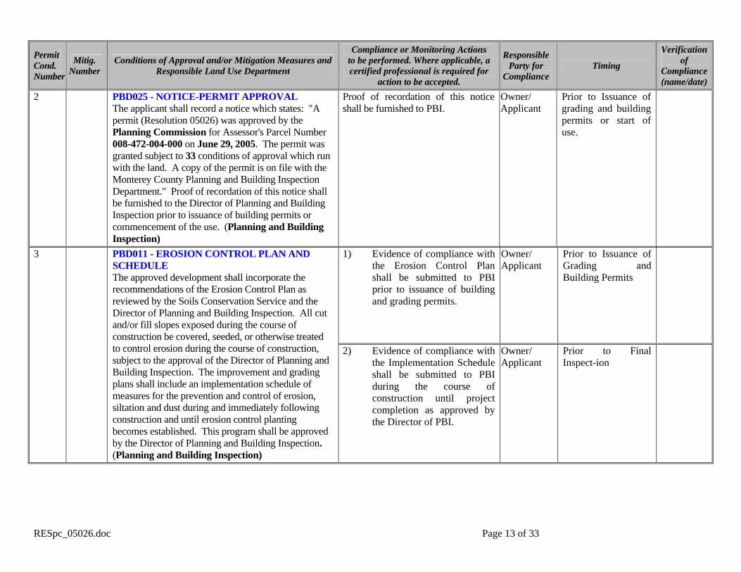
2 PBD025 - NOTICE-PERMIT APPROVAL The applicant shall record a notice which states: "A permit (Resolution 05026) was approved by the Planning Commission for Assessor's Parcel Number 008-472-004-000 on June 29, 2005. The permit was granted subject to 33 conditions of approval which run with the land. A copy of the permit is on file with the Monterey County Planning and Building Inspection Department." Proof of recordation of this notice shall be furnished to the Director of Planning and Building Inspection prior to issuance of building permits or commencement of the use. (Planning and Building Inspection)
Proof of recordation of this notice shall be furnished to PBI.
Owner/ Applicant
Prior to Issuance of grading and building permits or start of use.
1) Evidence of compliance with the Erosion Control Plan shall be submitted to PBI prior to issuance of building and grading permits.
Owner/ Applicant
Prior to Issuance of Grading and Building Permits
3 PBD011 - EROSION CONTROL PLAN AND SCHEDULE The approved development shall incorporate the recommendations of the Erosion Control Plan as reviewed by the Soils Conservation Service and the Director of Planning and Building Inspection. All cut and/or fill slopes exposed during the course of construction be covered, seeded, or otherwise treated to control erosion during the course of construction, subject to the approval of the Director of Planning and Building Inspection. The improvement and grading plans shall include an implementation schedule of measures for the prevention and control of erosion, siltation and dust during and immediately following construction and until erosion control planting becomes established. This program shall be approved by the Director of Planning and Building Inspection. (Planning and Building Inspection)
2) Evidence of compliance with the Implementation Schedule shall be submitted to PBI during the course of construction until project completion as approved by the Director of PBI.
Owner/ Applicant
Prior to Final Inspect-ion

RESpc_05026.doc Page 14 of 33
Permit Cond. Number
Mitig. Number
Conditions of Approval and/or Mitigation Measures and Responsible Land Use Department
Compliance or Monitoring Actions to be performed. Where applicable, a certified professional is required for
action to be accepted.
Responsible Party for
Compliance Timing
Verification of
Compliance (name/date)
4 PBD012 - FISH AND GAME FEE-NEG DEC/EIR Pursuant to the State Public Resources Code, State Fish and Game Code, and California Code of Regulations, the applicant shall pay a fee, to be collected by the County, within five (5) calendar days of project approval – prior to filling of the Notice of Determination. This fee ($1,275 payable to Monterey County Clerk) shall be paid on or before the filing of the Notice of Determination. Proof of payment shall be furnished by the applicant to the Director of Planning and Building Inspection prior to the recordation of the tentative map, the commencement of the use, or the issuance of building and/or grading permits, whichever occurs first. The project shall not be operative, vested or final until the filing fees are paid. (Planning and Building Inspection)
Proof of payment shall be furnished by the applicant to the Director of Planning and Building Inspection prior to the recordation of the tentative map, the commencement of the use, or the issuance of building and/or grading permits, whichever occurs first.
Owner/ Applicant
Prior to the record-ation of the tent-ative map, the start of the use or the issuance of build-ing and grading permits.
5 PBD014 - GRADING-WINTER RESTRICTION No land clearing or grading shall occur on the subject parcel between October 15 and April 15 unless authorized by the Director of Planning and Building Inspection. (Planning and Building Inspection)
None Owner/ Applicant
Ongoing
6 PBD018(A) - LANDSCAPE PLAN AND MAINTENANCE (SINGLE FAMILY DWELLING ONLY) The site shall be landscaped. At least 60 days prior to occupancy, three (3) copies of a landscaping plan shall be submitted to the Director of Planning and Building
Submit landscape plans and contractor’s estimate to PBI for review and approval. Also See Conditions 25, 30 & 31/Mitigation Measures 2, 7, & 8.
Owner/ Applicant/ Contractor
At least 60 days prior to final inspect-ion or occu-pancy

RESpc_05026.doc Page 15 of 33
Permit Cond. Number
Mitig. Number
Conditions of Approval and/or Mitigation Measures and Responsible Land Use Department
Compliance or Monitoring Actions to be performed. Where applicable, a certified professional is required for
action to be accepted.
Responsible Party for
Compliance Timing
Verification of
Compliance (name/date)
Inspection for approval. A landscape plan review fee is required for this project. Fees shall be paid at the time of landscape plan submittal. The landscaping plan shall be in sufficient detail to identify the location, species, and size of the proposed landscaping materials and shall be accompanied by a nursery or contractor's estimate of the cost of installation of the plan. Before occupancy, landscaping shall be either installed or a certificate of deposit or other form of surety made payable to Monterey County for that cost estimate shall be submitted to the Monterey County Planning and Building Inspection Department. All landscaped areas and fences shall be continuously maintained by the applicant; all plant material shall be continuously maintained in a litter-free, weed-free, healthy, growing condition. (Planning and Building Inspection)
All landscaped areas and fences shall be continuously maintained by the applicant; all plant material shall be continuously maintained in a litter-free, weed-free, healthy, growing condition.
Owner/ Applicant
Ongoing
7 PBD021 – LIGHTING – EXTERIOR LIGHTING PLAN All exterior lighting shall be unobtrusive, harmonious with the local area, and constructed or located so that only the intended area is illuminated and off-site glare is fully controlled. The applicant shall submit 3 copies of an exterior lighting plan which shall indicate the location, type, and wattage of all light fixtures and include catalog sheets for each fixture. The exterior lighting plan shall be subject to approval by the Director of Planning and Building Inspection, prior to the issuance of building permits. (Planning and Building Inspection)
Submit three copies of the lighting plans to PBI for review and approval. Also See Condition 26/Mitigation Measure 3.
Owner/ Applicant
Prior to issuance of building permits.

RESpc_05026.doc Page 16 of 33
Permit Cond. Number
Mitig. Number
Conditions of Approval and/or Mitigation Measures and Responsible Land Use Department
Compliance or Monitoring Actions to be performed. Where applicable, a certified professional is required for
action to be accepted.
Responsible Party for
Compliance Timing
Verification of
Compliance (name/date)
8 PBD022 - MITIGATION MONITORING PROGRAM The applicant shall enter into an agreement with the County to implement a Mitigation Monitoring and/or Reporting Plan in accordance with Section 21081.6 of the California Public Resources Code and Section 15097 of Title 14, Chapter 3 of the California Code of Regulations. Compliance with the fee schedule adopted by the Board of Supervisors for mitigation monitoring shall be required and payment made to the County of Monterey at the time the property owner submits the signed mitigation monitoring agreement. (Planning and Building Inspection)
1) Enter into agreement with the County to implement a Mitigation Monitoring Program.
2) Fees shall be submitted at the
time the property owner submits the signed mitigation monitoring agreement.
Owner/ Applicant
Within 60 days after project approval or prior to issu-ance of grading and building permits, which-ever occurs first.
9 PBD026 – NOTICE OF REPORT (BIOLOGY) Prior to issuance of building or grading permits, a notice shall be recorded with the Monterey County Recorder which states: "A Biological Report has been prepared for this parcel by Vernal L. Yadon, dated August 2001 with a supplemental report completed in September 2004 and is on record in the Monterey County Planning and Building Inspection Department. All current and future development shall be in accordance with this report unless amended." (Planning and Building Inspection)
Proof of recordation of this notice shall be furnished to PBI.
Owner/ Applicant
Prior to issuance of grading and building permits
10 PBD026 – NOTICE OF REPORT (FOREST MANAGEMENT) Prior to issuance of building or grading permits, a notice shall be recorded with the Monterey County Recorder which states: "A Forest Management Plan has been prepared for this parcel by Brian W. Fenske, dated January 2005 with an addendum dated February 2005 and is on record in the Monterey County Planning and Building Inspection Department. All current and future development shall be in accordance with this report unless amended." (Planning and Building Inspection)
Proof of recordation of this notice shall be furnished to PBI.
Owner/ Applicant
Prior to issuance of grading and building permits
RESpc_05026.doc Page 17 of 33
Permit Cond. Number
Mitig. Number
Conditions of Approval and/or Mitigation Measures and Responsible Land Use Department
Compliance or Monitoring Actions to be performed. Where applicable, a certified professional is required for
action to be accepted.
Responsible Party for
Compliance Timing
Verification of
Compliance (name/date)
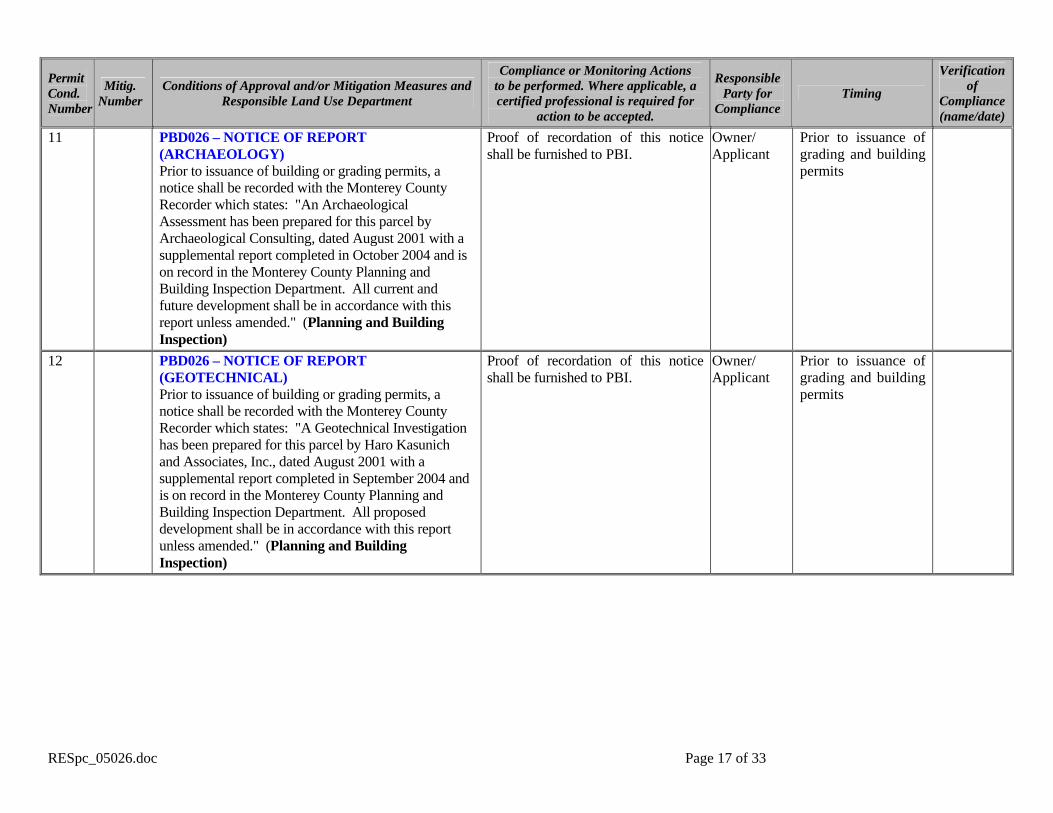
11 PBD026 – NOTICE OF REPORT (ARCHAEOLOGY) Prior to issuance of building or grading permits, a notice shall be recorded with the Monterey County Recorder which states: "An Archaeological Assessment has been prepared for this parcel by Archaeological Consulting, dated August 2001 with a supplemental report completed in October 2004 and is on record in the Monterey County Planning and Building Inspection Department. All current and future development shall be in accordance with this report unless amended." (Planning and Building Inspection)
Proof of recordation of this notice shall be furnished to PBI.
Owner/ Applicant
Prior to issuance of grading and building permits
12 PBD026 – NOTICE OF REPORT (GEOTECHNICAL) Prior to issuance of building or grading permits, a notice shall be recorded with the Monterey County Recorder which states: "A Geotechnical Investigation has been prepared for this parcel by Haro Kasunich and Associates, Inc., dated August 2001 with a supplemental report completed in September 2004 and is on record in the Monterey County Planning and Building Inspection Department. All proposed development shall be in accordance with this report unless amended." (Planning and Building Inspection)
Proof of recordation of this notice shall be furnished to PBI.
Owner/ Applicant
Prior to issuance of grading and building permits

RESpc_05026.doc Page 18 of 33
Permit Cond. Number
Mitig. Number
Conditions of Approval and/or Mitigation Measures and Responsible Land Use Department
Compliance or Monitoring Actions to be performed. Where applicable, a certified professional is required for
action to be accepted.
Responsible Party for
Compliance Timing
Verification of
Compliance (name/date)
13 PBD032(B) – TREE AND ROOT PROTECTION Trees which are located close to the construction site(s) shall be protected from inadvertent damage from construction equipment by fencing off the canopy driplines and/or critical root zones (whichever is greater) with protective materials, wrapping trunks with protective materials, avoiding fill of any type against the base of the trunks and avoiding an increase in soil depth at the feeding zone or drip-line of the retained trees. Said protection shall be demonstrated prior to issuance of building permits subject to the approval of the Director of Planning and Building Inspection. (Planning and Building Inspection)
Submit evidence of tree protection to PBI for review and approval. Also See Condition 28/Mitigation Measure 5.
Owner/ Applicant
Prior to Issuance of Grading and/or Building Permits
14 PBD034 - UTILITIES - UNDERGROUND All new utility and distribution lines shall be placed underground. (Planning and Building Inspection; Public Works)
None Applicant/ Owner
Ongoing
15 PBD040 – HEIGHT VERIFICATION The applicant shall have a benchmark placed upon the property and identify the benchmark on the building plans. The benchmark shall remain visible onsite until final building inspection. The applicant shall provide evidence from a licensed civil engineer or surveyor, to the Director of Planning and Building Inspection for review and approval, that the height of the structure(s) from the benchmark is consistent with what was approved on the building permit associated with this project. (Planning and Building Inspection)
1) The applicant shall have a benchmark placed upon the property and identify the benchmark on the building plans. The benchmark shall remain visible onsite until final building inspection
Owner/ Applicant
Prior to Issuance of Grading or Building Permits

RESpc_05026.doc Page 19 of 33
Permit Cond. Number
Mitig. Number
Conditions of Approval and/or Mitigation Measures and Responsible Land Use Department
Compliance or Monitoring Actions to be performed. Where applicable, a certified professional is required for
action to be accepted.
Responsible Party for
Compliance Timing
Verification of
Compliance (name/date)
16 PBD042 – GRADING PERMITS REQUIRED A grading permit is required for new private single family access driveways greater than fifty (50) feet in total length that require 100 cubic yards or more of earthwork. An over the counter (OTC) grading permit may be issued for new private single family access driveways greater than fifty (50) feet in total length that require less than 100 cubic yards of earthwork.. (Planning and Building Inspection)
If applicable, apply and receive the appropriate grading permit from Monterey County Planning and Building Inspection.
Engineer/ Owner/
Applicant
Prior to Issuance of Grading or Building Permits
MONTEREY COUNTY WATER RESOURCE AGENCY
17 DRAINAGE CONTROL (NON-STANDARD WORDING) Prior to issuance of any grading or building permits, a drainage plan shall be prepared by a registered civil engineer or architect addressing on-site and off-site impacts, to include dispersal of impervious surface stormwater runoff onto a non-erodible surface below the bluff. (Water Resources Agency)
Submit 3 copies of the drainage plan to the Water Resources Agency for review and approval. Also See Condition 33/Mitigation Measures 10.
Owner/ Applicant/ Emgineer
Prior to issuance of any grading or building permits

RESpc_05026.doc Page 20 of 33
Permit Cond. Number
Mitig. Number
Conditions of Approval and/or Mitigation Measures and Responsible Land Use Department
Compliance or Monitoring Actions to be performed. Where applicable, a certified professional is required for
action to be accepted.
Responsible Party for
Compliance Timing
Verification of
Compliance (name/date)
18 WR40 - WATER CONSERVATION MEASURES The applicant shall comply with Ordinance No. 3932, or as subsequently amended, of the Monterey County Water Resources Agency pertaining to mandatory water conservation regulations. The regulations for new construction require, but are not limited to: a. All toilets shall be ultra-low flush toilets with a maximum tank size or flush capacity of 1.6 gallons, all shower heads shall have a maximum flow capacity of 2.5 gallons per minute, and all hot water faucets that have more than ten feet of pipe between the faucet and the hot water heater serving such faucet shall be equipped with a hot water recirculating system. b. Landscape plans shall apply xeriscape principles, including such techniques and materials as native or low water use plants and low precipitation sprinkler heads, bubblers, drip irrigation systems and timing devices. (Water Resources Agency)
Compliance to be verified by building inspector at final inspection.
Owner/ Applicant
Prior to final building inspect-ion/ occupancy
19 WR43 - WATER AVAILABILITY CERTIFICATION The applicant shall obtain from the Monterey County Water Resources Agency, proof of water availability on the property, in the form of an approved Monterey Peninsula Water Management District Water Release Form. (Water Resources Agency)
Submit the Water Release Form to the Water Resources Agency for review and approval.
Owner/ Applicant
Prior to issuance of any building permits
CALIFORNIA DEPARTMENT OF FORESTRY (CDF) FIRE
20 FIRE008 - GATES All gates providing access from a road to a driveway shall be located at least 30 feet from the roadway and shall open to allow a vehicle to stop without obstructing traffic on the road. Gate entrances shall
Applicant shall incorporate specification into design and enumerate as “Fire Dept. Notes” on plans.
Applicant or owner
Prior to issuance of grading and/or building permit.

RESpc_05026.doc Page 21 of 33
Permit Cond. Number
Mitig. Number
Conditions of Approval and/or Mitigation Measures and Responsible Land Use Department
Compliance or Monitoring Actions to be performed. Where applicable, a certified professional is required for
action to be accepted.
Responsible Party for
Compliance Timing
Verification of
Compliance (name/date)
be at least the width of the traffic lane but in no case less than 12 feet wide. Where a one-way road with a single traffic lane provides access to a gated entrance, a 40-foot turning radius shall be used. Where gates are to be locked, the installation of a key box or other acceptable means for immediate access by emergency equipment may be required. CDF.
Applicant shall schedule fire dept. clearance inspection
Applicant or owner
Prior to final building inspection.
Applicant shall incorporate specification into design and enumerate as “Fire Dept. Notes” on plans.
Applicant or owner
Prior to issuance of building permit.
21 FIRE011 - ADDRESSES FOR BUILDINGS All buildings shall be issued an address in accordance with Monterey County Ordinance No. 1241. Each occupancy, except accessory buildings, shall have its own permanently posted address. When multiple occupancies exist within a single building, each individual occupancy shall be separately identified by its own address. Letters, numbers and symbols for addresses shall be a minimum of 4-inch height, 1/2-inch stroke, contrasting with the background color of the sign, and shall be Arabic. The sign and numbers shall be reflective and made of a noncombustible material. Address signs shall be placed at each driveway entrance and at each driveway split. Address signs shall be and visible from both directions of travel along the road. In all cases, the address shall be posted at the beginning of construction and shall be maintained thereafter. Address signs along one-way roads shall be visible from both directions of travel. Where multiple addresses are required at a single driveway, they shall be mounted on a single sign. Where a roadway provides access solely to a single commercial occupancy, the address sign shall be placed at the nearest road intersection providing access to that site. Permanent address numbers shall be posted prior to requesting final clearance. CDF.
Applicant shall schedule fire dept. clearance inspection
Applicant or owner
Prior to final building inspection
RESpc_05026.doc Page 22 of 33
Permit Cond. Number
Mitig. Number
Conditions of Approval and/or Mitigation Measures and Responsible Land Use Department
Compliance or Monitoring Actions to be performed. Where applicable, a certified professional is required for
action to be accepted.
Responsible Party for
Compliance Timing
Verification of
Compliance (name/date)
Applicant shall enumerate as “Fire Dept. Notes” on plans.
Applicant or owner
Prior to issuance of building permit.
Applicant shall schedule fire dept. rough sprinkler inspection
Applicant or owner
Prior to framing inspection
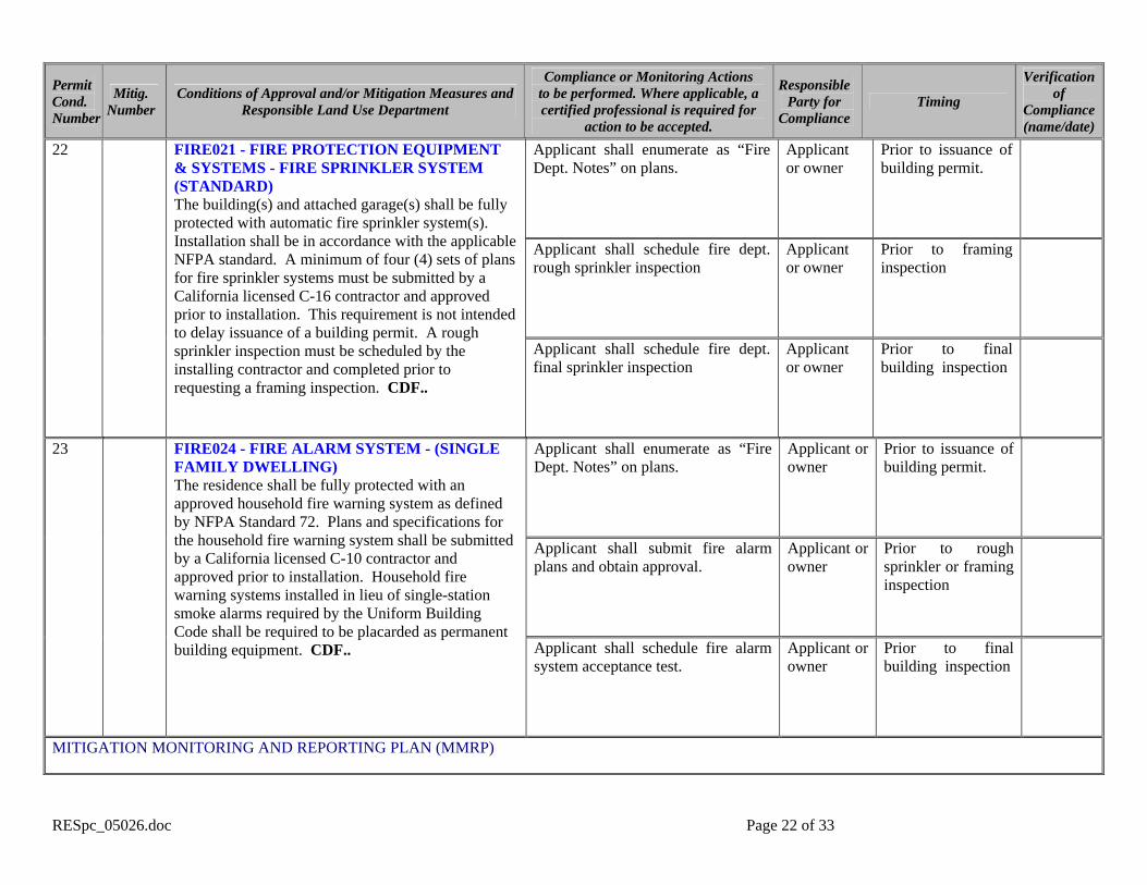
22 FIRE021 - FIRE PROTECTION EQUIPMENT & SYSTEMS - FIRE SPRINKLER SYSTEM (STANDARD) The building(s) and attached garage(s) shall be fully protected with automatic fire sprinkler system(s). Installation shall be in accordance with the applicable NFPA standard. A minimum of four (4) sets of plans for fire sprinkler systems must be submitted by a California licensed C-16 contractor and approved prior to installation. This requirement is not intended to delay issuance of a building permit. A rough sprinkler inspection must be scheduled by the installing contractor and completed prior to requesting a framing inspection. CDF..
Applicant shall schedule fire dept. final sprinkler inspection
Applicant or owner
Prior to final building inspection
Applicant shall enumerate as “Fire Dept. Notes” on plans.
Applicant or owner
Prior to issuance of building permit.
Applicant shall submit fire alarm plans and obtain approval.
Applicant or owner
Prior to rough sprinkler or framing inspection
23 FIRE024 - FIRE ALARM SYSTEM - (SINGLE FAMILY DWELLING) The residence shall be fully protected with an approved household fire warning system as defined by NFPA Standard 72. Plans and specifications for the household fire warning system shall be submitted by a California licensed C-10 contractor and approved prior to installation. Household fire warning systems installed in lieu of single-station smoke alarms required by the Uniform Building Code shall be required to be placarded as permanent building equipment. CDF.. Applicant shall schedule fire alarm
system acceptance test. Applicant or owner
Prior to final building inspection
MITIGATION MONITORING AND REPORTING PLAN (MMRP)

RESpc_05026.doc Page 23 of 33
Permit Cond. Number
Mitig. Number
Conditions of Approval and/or Mitigation Measures and Responsible Land Use Department
Compliance or Monitoring Actions to be performed. Where applicable, a certified professional is required for
action to be accepted.
Responsible Party for
Compliance Timing
Verification of
Compliance (name/date)
24 1 Aesthetic Impact 1 – 17-Mile Drive Set Back In order to preserve public views from 17-Mile Drive, a scenic easement shall be conveyed to the Pebble Beach Company over that portion of the property required as a front set back (100 feet from the centerline of 17-Mile Drive).
Submit an approved and recorded deed restriction to the Planning and Building Inspection.
Applicant Owner PBI
Prior to issuance of any permit
25 2 Aesthetic Impact 2 – Landscape In order to reduce impacts from landscaping that obscures views from 17-Mile Drive, all landscape materials except native plants materials within the conservation easement area shall be designed and maintained in such a manner that does not obscure any coastline view from 17-Mile Drive any more than the approved structures. There shall be no vines planted along the perimeter fence and shrubs in this area shall be limited to a species that naturally does not exceed three feet in height.
Submit Landscape and Irrigation Plans prepared by a licensed Landscape Architect for review and approval of the Planning and Building Inspection Department. Said plan shall identify plants materials (size, species, quantity), the maximum height allowed for mature plants, and proposed maintenance in a manner that meets the intent of this mitigation. Plant materials within, and adjacent to, the required scenic easement shall be native to and complimentary with native Monterey cypress habitat.
Applicant Owner PBI
Prior to issuance of permits
RESpc_05026.doc Page 24 of 33
Permit Cond. Number
Mitig. Number
Conditions of Approval and/or Mitigation Measures and Responsible Land Use Department
Compliance or Monitoring Actions to be performed. Where applicable, a certified professional is required for
action to be accepted.
Responsible Party for
Compliance Timing
Verification of
Compliance (name/date)
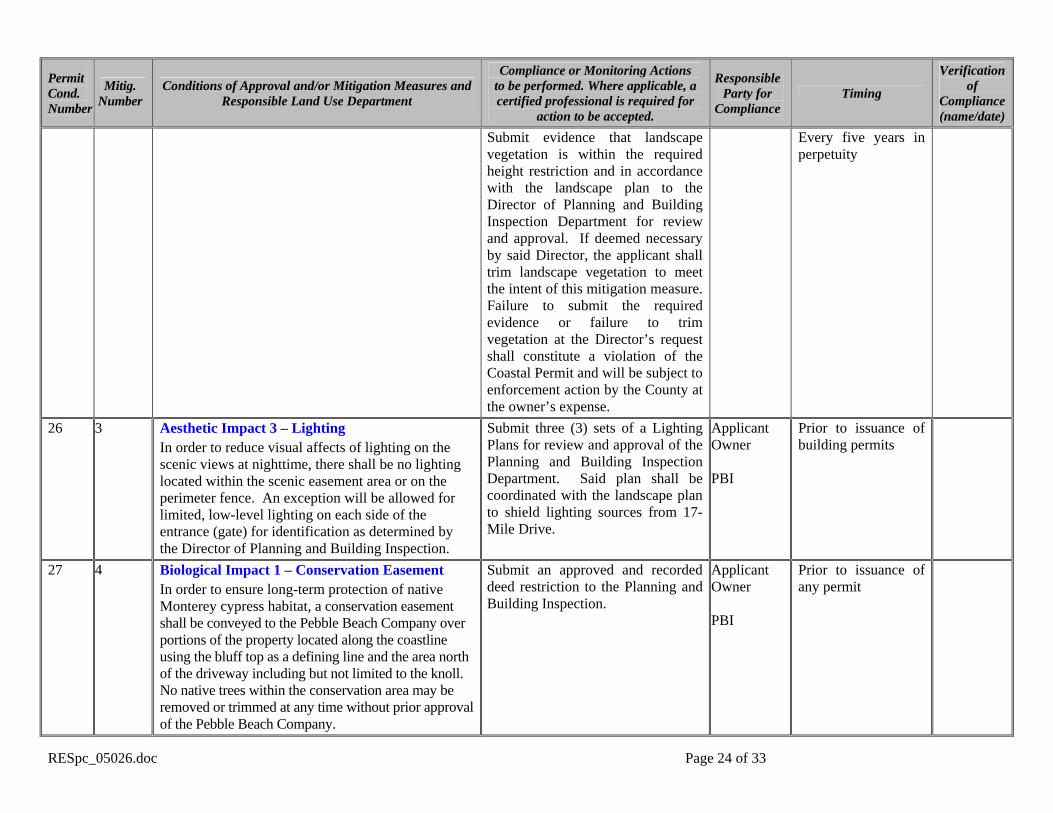
Submit evidence that landscape vegetation is within the required height restriction and in accordance with the landscape plan to the Director of Planning and Building Inspection Department for review and approval. If deemed necessary by said Director, the applicant shall trim landscape vegetation to meet the intent of this mitigation measure. Failure to submit the required evidence or failure to trim vegetation at the Director’s request shall constitute a violation of the Coastal Permit and will be subject to enforcement action by the County at the owner’s expense.
Every five years in perpetuity
26 3 Aesthetic Impact 3 – Lighting In order to reduce visual affects of lighting on the scenic views at nighttime, there shall be no lighting located within the scenic easement area or on the perimeter fence. An exception will be allowed for limited, low-level lighting on each side of the entrance (gate) for identification as determined by the Director of Planning and Building Inspection.
Submit three (3) sets of a Lighting Plans for review and approval of the Planning and Building Inspection Department. Said plan shall be coordinated with the landscape plan to shield lighting sources from 17-Mile Drive.
Applicant Owner PBI
Prior to issuance of building permits
27 4 Biological Impact 1 – Conservation Easement In order to ensure long-term protection of native Monterey cypress habitat, a conservation easement shall be conveyed to the Pebble Beach Company over portions of the property located along the coastline using the bluff top as a defining line and the area north of the driveway including but not limited to the knoll. No native trees within the conservation area may be removed or trimmed at any time without prior approval of the Pebble Beach Company.
Submit an approved and recorded deed restriction to the Planning and Building Inspection.
Applicant Owner PBI
Prior to issuance of any permit

RESpc_05026.doc Page 25 of 33
Permit Cond. Number
Mitig. Number
Conditions of Approval and/or Mitigation Measures and Responsible Land Use Department
Compliance or Monitoring Actions to be performed. Where applicable, a certified professional is required for
action to be accepted.
Responsible Party for
Compliance Timing
Verification of
Compliance (name/date)
Submit a revised Forest Management Plan prepared by a qualified arborist that incorporates the guidelines listed in this mitigation measure. Said plan shall be peer reviewed by a qualified biologist and a letter of the biologists findings shall be submitted to the Planning and Building Inspection Department.
Prior to issuance of grading or building permits
Provide signed copies of a contract with a qualified biologist and arborist to the Director of Planning and Building Inspection for approval. The contract shall outline the supervisory and monitoring responsibilities of these professionals for at least 5 years, as prescribed by this mitigation measure. A copy of their professional credentials shall be referenced by and attached to the contract.
Prior to issuance of grading or building permits
28 5 Biological Impact 2 – Forest Management In order to ensure the short-term and long-term protection of Monterey cypress trees on the project site, the Forest Management Plan shall include the following: A. The project shall be designed and sited to avoid
removal of any Monterey cypress trees except for two 10-inch trees that are to be relocated as part of this project.
B. During construction, temporary fencing shall be installed and maintained along the construction zone boundary and/or scenic and conservation easement area boundary, as determined appropriate by a qualified biologist. Soil compaction, parking of vehicles or heavy equipment, stockpiling of construction materials, and/or dumping of materials shall not be allowed within the protected zone. Fencing shall be installed prior to issuance of any permits and shall remain in place during the entire construction period.
C. Trees located adjacent to the construction area shall be protected from damage by installing protective fencing around the dripline of all Monterey cypress trees and around the trunks of Monterey pine trees.
D. Any tree trimming required to facilitate construction activities shall be preformed by a qualified arborist and shall be minimized to the maximum extent possible. Said trimming shall require County staff to assess the work prior to any trimming taking place.
The project biologist and arborist shall submit annual monitoring reports, subject to the Director’s approval, to the Planning and Building Inspection. See also Condition 31/Mitigation Measure 8.
Applicant Owner Arborist Biologist PBI
Once a year for five years from the date of occupancy

RESpc_05026.doc Page 26 of 33
Permit Cond. Number
Mitig. Number
Conditions of Approval and/or Mitigation Measures and Responsible Land Use Department
Compliance or Monitoring Actions to be performed. Where applicable, a certified professional is required for
action to be accepted.
Responsible Party for
Compliance Timing
Verification of
Compliance (name/date)
Survey and stake building envelopes as well as grading and trenching limits on the site. Said staking shall be subject to review by the Planning and Building Inspection Department and the project design shall be modified where PBI identifies potential impact to Monterey cypress trees.
Prior to construction

RESpc_05026.doc Page 27 of 33
Permit Cond. Number
Mitig. Number
Conditions of Approval and/or Mitigation Measures and Responsible Land Use Department
Compliance or Monitoring Actions to be performed. Where applicable, a certified professional is required for
action to be accepted.
Responsible Party for
Compliance Timing
Verification of
Compliance (name/date)
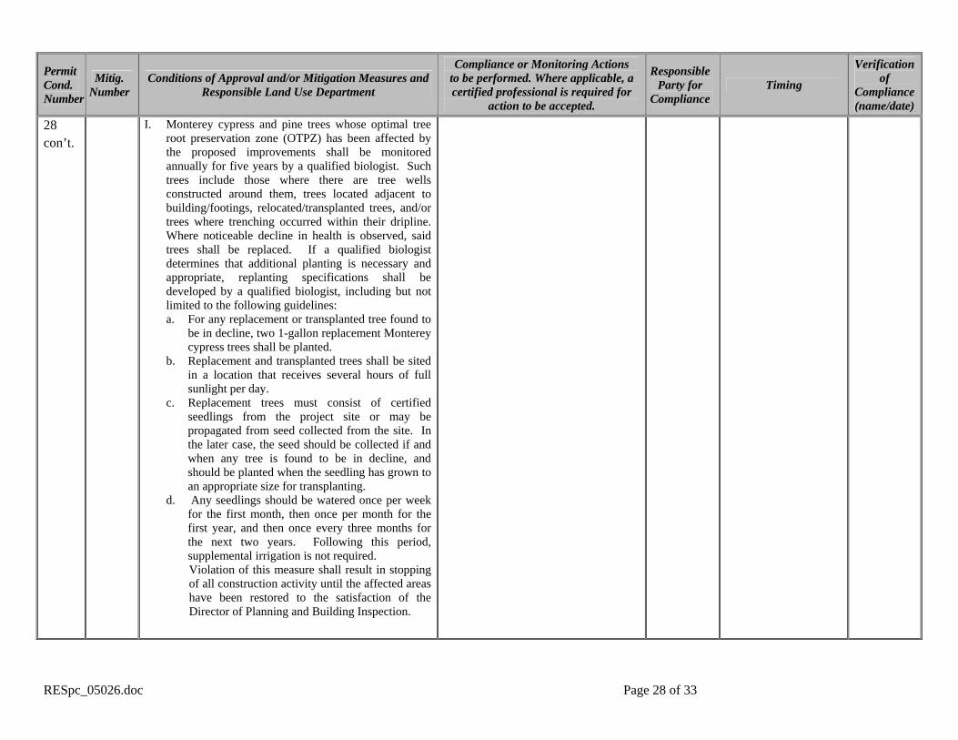
28 con’t.
E. During grading and excavation activities, no work shall take place within driplines of Monterey cypress trees unless the Director of Planning and Building Inspection finds that three is no alternative. Where no alternative exists, the work shall be monitored by a qualified biologist to ensure against drilling or cutting into or through major roots.
F. Any trenching, grading or any other digging or soil removal under the root spread of cypress and/or pine trees shall be done manually, digging a trench and cutting exposed roots with a saw, vibrating knife, rock saw, narrow trencher with sharp blades, or other root-pruning equipment approved by a qualified biologist, in order to prevent the unnecessary fracture of major roots. Required footings shall be designed to avoid major roots. The project architect and qualified biologist shall be on site during excavation activities to direct any minor field adjustments that may be needed. Roots greater than two (2) inches in diameter shall not be cut and shall involve bridging or tunneling to be performed under the supervision of a qualified biologist. Before drilling holes for foundation pilings, a test hole shall be initiated using a 3-foot long hydraulic root-feeding-needle under pressure to disclose the presence of roots before drilling with an auger. After determining suitable zones for boring, a two-man hand-held auger shall be used.
G. Any roots damaged during grading or excavation shall be exposed to sound tissue and cut cleanly with a saw under direction of a qualified arborist.
H. Irrigation, fertilization and fungicide treatments for trees that have root spread affected by construction shall be prescribed in the Forest Management Plan to be implemented under supervision of a qualified arborist.
RESpc_05026.doc Page 28 of 33
Permit Cond. Number
Mitig. Number
Conditions of Approval and/or Mitigation Measures and Responsible Land Use Department
Compliance or Monitoring Actions to be performed. Where applicable, a certified professional is required for
action to be accepted.
Responsible Party for
Compliance Timing
Verification of
Compliance (name/date)
28 con’t.
I. Monterey cypress and pine trees whose optimal tree root preservation zone (OTPZ) has been affected by the proposed improvements shall be monitored annually for five years by a qualified biologist. Such trees include those where there are tree wells constructed around them, trees located adjacent to building/footings, relocated/transplanted trees, and/or trees where trenching occurred within their dripline. Where noticeable decline in health is observed, said trees shall be replaced. If a qualified biologist determines that additional planting is necessary and appropriate, replanting specifications shall be developed by a qualified biologist, including but not limited to the following guidelines: a. For any replacement or transplanted tree found to
be in decline, two 1-gallon replacement Monterey cypress trees shall be planted.
b. Replacement and transplanted trees shall be sited in a location that receives several hours of full sunlight per day.
c. Replacement trees must consist of certified seedlings from the project site or may be propagated from seed collected from the site. In the later case, the seed should be collected if and when any tree is found to be in decline, and should be planted when the seedling has grown to an appropriate size for transplanting.
d. Any seedlings should be watered once per week for the first month, then once per month for the first year, and then once every three months for the next two years. Following this period, supplemental irrigation is not required. Violation of this measure shall result in stopping of all construction activity until the affected areas have been restored to the satisfaction of the Director of Planning and Building Inspection.

RESpc_05026.doc Page 29 of 33
Permit Cond. Number
Mitig. Number
Conditions of Approval and/or Mitigation Measures and Responsible Land Use Department
Compliance or Monitoring Actions to be performed. Where applicable, a certified professional is required for
action to be accepted.
Responsible Party for
Compliance Timing
Verification of
Compliance (name/date)
29 6 Biological Impact 3 – Invasive Plants In order to eliminate and control invasive exotic plants onsite, a program shall be developed for removing, controlling, and preventing the introduction of invasive exotic plants as they appear on the property, such as Iceplant, French Bloom, Cape Ivy, Pampas Grass, Kikuyu Grass, Acacias, etc. Any areas disturbed by construction shall be revegetated with native vegetation associated with the Monterey cypress understory, as appropriate. Immediate eradication efforts shall be directed at the iceplant growing onsite, and shall be accomplished by manual application of the water-soluble, non-persistent herbicide “Roundup.” The operator shall be careful not to spray the native plants. Best results are achieved when the plant is actively growing, usually during the spring or summer. Spraying shall be conducted only when the wind velocity is less than 5 mph and when no rain is anticipated within 24 hours. At least one follow-up application shall be applied to ensure a complete kill.
A qualified biologist shall prepare a weed-control program. A copy of the program shall be submitted to the Monterey County Planning and Building Inspection Department, subject to the approval of the Director, prior to issuance of grading and/or building permits. The qualified biologist shall conduct site inspections annually for at least three consecutive years to verify that the weed control program is being implemented and that invasive and/or exotic weedy plants are eradicated from the site. Said verification shall be submitted annually to the Director of Planning and Building Inspection. Successful compliance with Mitigation Measure 6 shall be based on three (3) consecutive years of the verified eradication of invasive and/or exotic plant species throughout the subject parcel, plus inspections once again at 5 years and 10 years, starting after three (3) consecutive years of verified successful compliance. If ongoing successful eradication cannot be verified at the fifth- or tenth-year inspections, the inspection process shall start over again in the manner described above, including the fifth- and tenth-year subsequent inspections and success criteria, until such time that complete eradication can be successfully verified at the end of the tenth-year inspection, starting from the end of three (3) consecutive years of verified eradication of invasive exotic plant species throughout the subject parcel.
Applicant Owner Biologist PBI
Prior issuance of grading and/or building permits

RESpc_05026.doc Page 30 of 33
Permit Cond. Number
Mitig. Number
Conditions of Approval and/or Mitigation Measures and Responsible Land Use Department
Compliance or Monitoring Actions to be performed. Where applicable, a certified professional is required for
action to be accepted.
Responsible Party for
Compliance Timing
Verification of
Compliance (name/date)
30 7 Biological Impact 4 – Native Vegetation In order to avoid the summer watering of Monterey cypress trees onsite, as required by Section 20.147.040.C.1.e of the Regulations for Development in the Del Monte Forest Land Use Plan, all existing turf, and all ornamental landscaping plants within the understory of any Monterey cypress trees onsite that cannot subsist without summer irrigation, shall be replaced by native vegetation associated with the Monterey cypress understory, or other acceptable non-invasive drought-tolerant plans. All landscaping shall apply xeriscape principles, including such techniques and materials as native or low water use plants and low precipitation sprinkler heads, bubblers, drip irrigation systems and timing devices. Together with the monitoring required for the elimination and control invasive exotic plants onsite by Mitigation Measure 6, the qualified biologist shall also note in the inspection reports the health and success of the areas revegetated in accordance with the approved landscaping/revegetation plan (as required below). The applicant or future owners shall make every effort to successfully address the issues raised in the approved inspection reports from the landscape biologist.
Submit a landscaping/revegetation plan that addresses areas impacted by construction and the elimination and control of invasive exotic plants onsite, as required by Mitigation Measure 6, and that also addresses the requirements of Mitigation Measure 7. Said plan shall be subject to the approval of the Director of Planning and Building Inspection prior to the granting of final occupancy.
Applicant Owner PBI
Prior to final inspection/occupancy
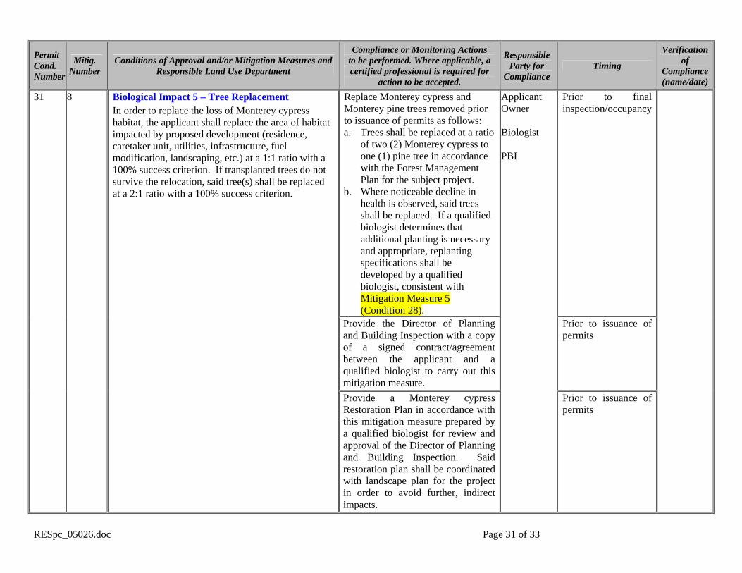
RESpc_05026.doc Page 31 of 33
Permit Cond. Number
Mitig. Number
Conditions of Approval and/or Mitigation Measures and Responsible Land Use Department
Compliance or Monitoring Actions to be performed. Where applicable, a certified professional is required for
action to be accepted.
Responsible Party for
Compliance Timing
Verification of
Compliance (name/date)
Replace Monterey cypress and Monterey pine trees removed prior to issuance of permits as follows: a. Trees shall be replaced at a ratio
of two (2) Monterey cypress to one (1) pine tree in accordance with the Forest Management Plan for the subject project.
b. Where noticeable decline in health is observed, said trees shall be replaced. If a qualified biologist determines that additional planting is necessary and appropriate, replanting specifications shall be developed by a qualified biologist, consistent with Mitigation Measure 5 (Condition 28).
Prior to final inspection/occupancy
Provide the Director of Planning and Building Inspection with a copy of a signed contract/agreement between the applicant and a qualified biologist to carry out this mitigation measure.
Prior to issuance of permits
31 8 Biological Impact 5 – Tree Replacement In order to replace the loss of Monterey cypress habitat, the applicant shall replace the area of habitat impacted by proposed development (residence, caretaker unit, utilities, infrastructure, fuel modification, landscaping, etc.) at a 1:1 ratio with a 100% success criterion. If transplanted trees do not survive the relocation, said tree(s) shall be replaced at a 2:1 ratio with a 100% success criterion.
Provide a Monterey cypress Restoration Plan in accordance with this mitigation measure prepared by a qualified biologist for review and approval of the Director of Planning and Building Inspection. Said restoration plan shall be coordinated with landscape plan for the project in order to avoid further, indirect impacts.
Applicant Owner Biologist PBI
Prior to issuance of permits

RESpc_05026.doc Page 32 of 33
Permit Cond. Number
Mitig. Number
Conditions of Approval and/or Mitigation Measures and Responsible Land Use Department
Compliance or Monitoring Actions to be performed. Where applicable, a certified professional is required for
action to be accepted.
Responsible Party for
Compliance Timing
Verification of
Compliance (name/date)
Provide the Director of Planning and Building Inspection written certification by a qualified biologist that all required replacement planting has been successfully completed and that no additional mitigation is required.
Prior to final inspection
Report in writing to the Director of Planning and Building Inspection on the status of restoration. The reports shall be prepared by a qualified biologist and shall include performance measures and corrective measures as needed. Planting shall be sufficient to replace lost vegetation (1:1 ratio) with a 100% success criterion. Failure to meet this success standard in any given year shall require immediate replacement planting and shall extend the monitoring period for an additional year.
Once a year for a period of five years following occupancy
Provide the Director of Planning and Building Inspection with a copy of a signed contract/agreement between the applicant and a qualified archaeologist to carry out this mitigation measure.
Prior to issuance of permits
32 9 Cultural Impact 1 – Archaeological Resources In order to provide protection for the cultural resources on the project parcel and mitigation of anticipated project impacts, the applicant/owner shall include the following. a. A County approved archaeological monitor shall
be present during demolition or construction activities that involve earth disturbance, such as excavation for new foundations, footings, drains, utilities, etc. If human remains or intact cultural features are discovered during construction, work
Submit an approved and recorded deed restriction to the Planning and Building Inspection.
Applicant Owner PBI
Prior to issuance of any permit
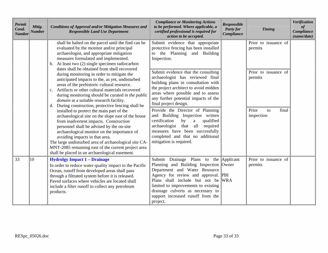
RESpc_05026.doc Page 33 of 33
Permit Cond. Number
Mitig. Number
Conditions of Approval and/or Mitigation Measures and Responsible Land Use Department
Compliance or Monitoring Actions to be performed. Where applicable, a certified professional is required for
action to be accepted.
Responsible Party for
Compliance Timing
Verification of
Compliance (name/date)
Submit evidence that appropriate protective fencing has been installed to the Planning and Building Inspection.
Prior to issuance of permits
Submit evidence that the consulting archaeologist has reviewed final building plans in consultation with the project architect to avoid midden areas where possible and to assess any further potential impacts of the final project design.
Prior to issuance of permits
shall be halted on the parcel until the find can be evaluated by the monitor and/or principal archaeologist, and appropriate mitigation measures formulated and implemented.
b. At least two (2) single specimen radiocarbon dates shall be obtained from shell recovered during monitoring in order to mitigate the anticipated impacts to the, as yet, undisturbed areas of the prehistoric cultural resource.
c. Artifacts or other cultural materials recovered during monitoring should be curated in the public domain at a suitable research facility.
d. During construction, protective fencing shall be installed to protect the main part of the archaeological site on the slope east of the house from inadvertent impacts. Construction personnel shall be advised by the on-site archaeological monitor on the importance of avoiding impacts in that area.
The large undisturbed area of archaeological site CA-MNT-2085 remaining east of the current project area shall be placed in an archaeological easement.
Provide the Director of Planning and Building Inspection written certification by a qualified archaeologist that all required measures have been successfully completed and that no additional mitigation is required.
Prior to final inspection
33 10 Hydrolgy Impact 1 – Drainage In order to reduce water quality impact to the Pacific Ocean, runoff from developed areas shall pass through a filtrated system before it is released. Paved surfaces where vehicles are located shall include a filter runoff to collect any petroleum products.
Submit Drainage Plans to the Planning and Building Inspection Department and Water Resource Agency for review and approval. Plans shall include but not be limited to improvements to existing drainage culverts as necessary to support increased runoff from the project.
Applicant Owner PBI WRA
Prior to issuance of permits