Road Safety Audit · wisconsin department of transportation zoo interchange reduced impacts...
42
WISCONSIN DEPARTMENT OF TRANSPORTATION ZOO INTERCHANGE REDUCED IMPACTS ALTERNATIVE MILWAUKEE COUNTY: ROAD SAFETY AUDIT
Transcript of Road Safety Audit · wisconsin department of transportation zoo interchange reduced impacts...
WISCONSIN DEPARTMENT OF TRANSPORTATION
ZOO INTERCHANGE
REDUCED IMPACTS
ALTERNATIVE
MILWAUKEE COUNTY:
ROAD SAFETY AUDIT

WISCONSIN DEPARTMENT OF TRANSPORTATION
ZOO INTERCHANGE REDUCED
IMPACTS ALTERNATIVE,
MILWAUKEE COUNTY:
ROAD SAFETY AUDIT
Opus International Consultants Inc.
Prepared by:
Margaret Myers
Transportation Engineer
Andrew H. Ceifetz, P.E.
Senior Transportation Engineer
Jeffrey Bagdade, P.E.
Vice President
FINAL REPORT
December, 2011
H-U0219.13
6230 Orchard Lake Road
Suite 110
West Bloomfield, MI 48322
Tel: 248 539 2222
Fax: 248 539 3670
www.opusinternational.com

ZOO INTERCHANGE RECONSTRUCTION, MILWAUKEE COUNTY: ROAD SAFETY AUDIT
THIS PAGE INTENTIONALLY LEFT BLANK
ZOO INTERCHANGE RECONSTRUCTION,
MILWAUKEE COUNTY: ROAD SAFETY AUDIT
Table of Contents
1.0 INTRODUCTION 1
1.1 Background ........................................................................................................................ 1
1.2 Road Safety Audits ........................................................................................................... 2
1.3 Reminder ............................................................................................................................ 2
1.4 RSA Scope ........................................................................................................................ 2
1.5 RSA Team and Process .................................................................................................. 3
2.0 AUDIT FINDINGS 6
2.1 Safety Benefits of the Reduced Impacts Alternative Design ...................................... 6
2.2 Existing Safety Features .................................................................................................. 8
2.3 Summary of Audit Findings ............................................................................................. 8
3.0 ROAD SAFETY AUDIT TEAM AND MATERIALS 12
4.0 SITE VISIT NOTES 13
5.0 ROAD SAFETY AUDIT ISSUES AND SUGGESTIONS 14
APPENDIX A: WISDOT RESPONSES
TABLE 1-1 FREQUENCY RATING ......................................................................................................... 4
TABLE 1-2 CRASH SEVERITY RATING ............................................................................................... 4
TABLE 1-3 CRASH RISK ASSESSMENT ............................................................................................. 5
TABLE 2-1 SUMMARY OF RSA SAFETY ISSUES AND SUGGESTIONS ..................................... 9

ZOO INTERCHANGE RECONSTRUCTION,
MILWAUKEE COUNTY: ROAD SAFETY AUDIT
1
1.0 INTRODUCTION
1.1 Background
The Zoo Interchange Reconstruction Project in Milwaukee County is a major upgrade to sections of IH-94, IH-894 and USH-45 in western Milwaukee County. The project includes the upgrade of the Zoo Interchange and reconstruction of the freeways and selected arterials. The scope of this project extends to include the approach legs of the Zoo Interchange in all directions. The roadway network included in this project serves business and industrial parks, tourism, and growing commercial and residential areas in western Milwaukee County. This creates high levels of demand within the study network and increases the potential for conflicts between long-distance traffic (including trucks associated with the industrial areas along the freeway), local traffic, and non-motorized traffic near the interchanges. The project area is shown below in FIGURE 1.1.
Figure 1-1 PROJECT AREA

ZOO INTERCHANGE RECONSTRUCTION,
MILWAUKEE COUNTY: ROAD SAFETY AUDIT
2
The preceding map represents the study area of the Zoo Interchange. The extended limits of the project are described below in Section 1.4 RSA Scope.
This “Reduced Impacts Alternative” design includes safety improvements throughout the study area. All left-exit ramps have been removed and replaced with direct, right-exit ramps. Additionally, arterial interchanges have been moved away from the mainline interchange. This, the newest design alternative, incorporates the greatest number of safety improvements and meets design standards.
The expansion and upgrades, described in Section 1.4 below, are currently at the 30% design phase. Opus International Consultants was retained by the Wisconsin Department of Transportation (WisDOT) to perform a road safety audit (RSA) of the proposed improvements designed as part of the Zoo Interchange Reconstruction Project. This report discusses the findings of the RSA.
1.2 Road Safety Audits
A Road Safety Audit (RSA) is a formal safety performance examination of an existing or future road or intersection by an independent RSA team. RSAs help to promote road safety by identifying safety issues at the design and implementation stages, promoting awareness of safe design practices, integrating multimodal safety concerns, and considering human factors in the design.
1.3 Reminder
The RSA team has conducted this audit to the best of its professional abilities within the time available and by referring to available information. While every attempt has been made to identify significant safety issues, the design team and the project owner are reminded that responsibility for the design, construction, and performance of the project remains with the engineers of record.
1.4 RSA Scope
The Wisconsin Department of Transportation (WisDOT) is currently planning to reconstruct and expand the freeway network near the Zoo Interchange. This includes upgrades to the system and service interchanges, main line freeway segments and local roads. The limits of the RSA included:
North: USH-45 at the Burleigh Street Interchange
South: IH-894/USH-45 at the Lincoln Avenue Interchange
East: IH-94 at 76th Street
West: IH-94 at 124th Street
The following service interchanges, whose corresponding numbers can be found on Figure 1-1, were evaluated during this RSA:
1. IH-894/USH-45 and Lincoln Avenue Interchange

ZOO INTERCHANGE RECONSTRUCTION,
MILWAUKEE COUNTY: ROAD SAFETY AUDIT
3
2. IH-894/USH-45 and Greenfield Avenue Interchange
3. USH-45 and Bluemound Road Interchange
4. USH-45 and Wisconsin Avenue Interchange
5. USH-45 and Watertown Plank Road Interchange
6. USH-45 and Mayfair Road Interchange
7. USH-45 and North Avenue Interchange
8. USH-45 and Burleigh Street Interchange
9. IH-94 and 84th Street Interchange
10. IH-94 and 124th Street Interchange
1.5 RSA Team and Process
The audit team and the project material on which the RSA was based are described in Section 3.
Site visits were conducted in October, 2011, to gain an understanding of the existing conditions and surroundings, as well as to identify existing safety concerns.
The RSA framework, which was developed by Opus for WisDOT, was applied in both the RSA analysis and presentation of findings. The expected frequency and severity of crashes caused by each safety issue have been identified and rated according to the categories shown in TABLES 1.1 and 1.2. These two risk elements were then combined to obtain a risk assessment on the basis of the matrix shown in TABLE 1.3. Consequently, each safety issue is assessed on the basis of a ranking between F (highest risk and highest priority) and A (lowest risk and lowest priority).
For each safety issue identified, possible mitigation measures have been suggested. The suggestions have focused on measures that can be cost-effectively implemented at the current design stage, and consequently include few major geometric changes.

ZOO INTERCHANGE RECONSTRUCTION,
MILWAUKEE COUNTY: ROAD SAFETY AUDIT
4
Table 1-1 FREQUENCY RATING
ESTIMATED EXPECTED CRASH FREQUENCY (per audit item)
FREQUENCY RATING EXPOSURE PROBABILITY
high high 10 or more crashes per year Frequent
medium high
high medium
1 to 9 crashes per year Occasional medium medium
low high
high low less than 1 crash per year, but more than 1 crash every 5 years Infrequent
low medium
medium low less than 1 crash every 5 years Rare
low low
Table 1-2 CRASH SEVERITY RATING
TYPICAL CRASHES EXPECTED
(per audit item)
EXPECTED CRASH SEVERITY
SEVERITY RATING
crashes involving high speeds or heavy vehicles, pedestrians, or bicycles
probable fatality or incapacitating injury High
crashes involving medium to high speed;
head-on, crossing, or off-road crashes moderate to severe injury Moderate
crashes involving medium to low speeds;
left-turn and right-turn crashes minor to moderate injury Low
crashes involving low to medium speeds;
rear-end or sideswipe crashes
property damage only or minor injury Negligible
ZOO INTERCHANGE RECONSTRUCTION,
MILWAUKEE COUNTY: ROAD SAFETY AUDIT
5
Table 1-3 CRASH RISK ASSESSMENT
FREQUENCY RATING
SEVERITY RATING
Negligible Low Moderate High
Frequent C D E F
Occasional B C D E
Infrequent A B C D
Rare A A B C
Crash Risk Ratings: A: minimal risk level D: significant risk level
B: low risk level E: high risk level
C: moderate risk level F: extreme risk level
ZOO INTERCHANGE RECONSTRUCTION,
MILWAUKEE COUNTY: ROAD SAFETY AUDIT
6
2.0 AUDIT FINDINGS
2.1 Safety Benefits of the Reduced Impacts Alternative Design The improvements which are being proposed as part of the Zoo Interchange Reduced Impacts Alternative are motivated by the goal of reducing the total cost of the project in addition to reducing congestion and traffic crashes for all users including long-distance/industrial traffic and local/regional traffic in both Milwaukee and eastern Waukesha counties. In addition, the freeway and many features of its design already incorporate many enhancements that are expected to substantially improve traffic safety in the area:
Right-side ramps: Existing left-side entry and exit ramps will be replaced with right-side ramps. Right-side entry and exit ramps will better meet driver expectations, and reduce the collision risk associated with both late lane changes and mixing higher-speed through traffic in the left-lanes with slower speed entering and exiting vehicles.
The 2005 ITE Freeway and Interchange Geometric Design Handbook1 states that in the early 1960s significant operational problems existed with many of the left exit and entrance interchanges. It suggested that all right exits and entrances should be incorporated into a system interchange to provide safer operations and remain consistent with driver expectations.
Increased Shoulder Width on USH-45: The shoulders on USH-45 will be increased to 12 feet, the interstate standard, and as much as 18 feet in some areas. This additional shoulder width will allow for more space to recover for motorists who have left the roadway. This added width also allows for the potential expansion of USH-45 as traffic volumes increase. This change addresses a concern noted in the Interstate Conversion geometric deficiencies report.
Sidewalks and Pedestrian Refuges: The Reduced Impacts Alternative incorporates sidewalks and pedestrian refuges as part of the new design. Sidewalks have been recommended for the length of STH-100 within the limits of this project. New or improved pedestrian refuges and crosswalks have also been suggested to improve the connectivity of the existing network and to improve safety for non-motorized users.
Reduced congestion: The proposed cross-section expands IH-894 and USH-45 from a six-lane to an eight-lane cross-section, to accommodate increased traffic growth. Increasing capacity through the segments of IH-94, IH-894 and USH-45 and the Zoo Interchange will reduce speed variation and travel time which may lead to a reduction in crashes along the mainline.
Eliminating short merge distances: Proposed ramp entrances provide drivers with extended merge distances to safely transition onto the freeway. Short merge distances lead to erratic weaving
1 Institute of Transportation Engineers, Freeway and Interchange Geometric Design Handbook (2005).
ZOO INTERCHANGE RECONSTRUCTION,
MILWAUKEE COUNTY: ROAD SAFETY AUDIT
7
movements and unexpected braking. By extending merge distances a decrease in sideswipe, rear-end and run off the road crashes can be expected.
Improved weaving distances: The proposed design improves weaving distances between successive ramps along the freeway system. By increasing the total distance available for drivers to make transitional maneuvers, the likelihood of collisions as a result of short weaving distances is reduced.
ZOO INTERCHANGE RECONSTRUCTION,
MILWAUKEE COUNTY: ROAD SAFETY AUDIT
8
2.2 Existing Safety Features
Existing safety features of the roadways included within the Zoo Interchange Reconstruction Project are incorporated in the proposed design to maintain their effective traffic safety performance within the project limits:
Concrete median barrier: The continuous concrete median barriers along the roadways approaching the Zoo Interchange significantly reduce the number of median crossover crashes and their severity throughout the corridor. Specifically, the median barriers prevent head-on crashes associated with vehicles crossing the median.
Wide shoulders: Some roadways approaching the Zoo Interchange provide a wide shoulder. This existing element contributes to safety by a moderate reduction in crash frequency and a high reduction in crash severity due to the recovery room/refuge.
Lighting: Lighting is provided throughout the study area, improving corridor conspicuity and visibility during night time hours.
2.3 Summary of Audit Findings
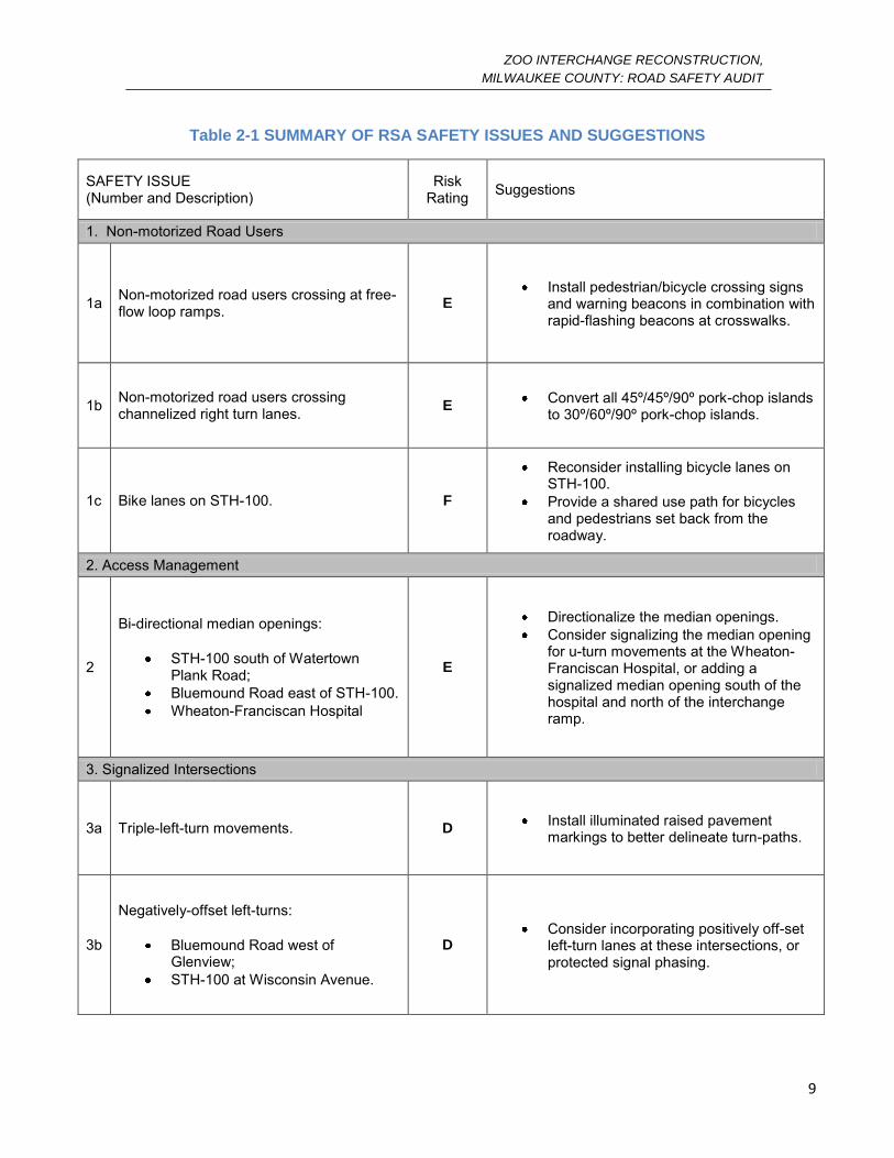
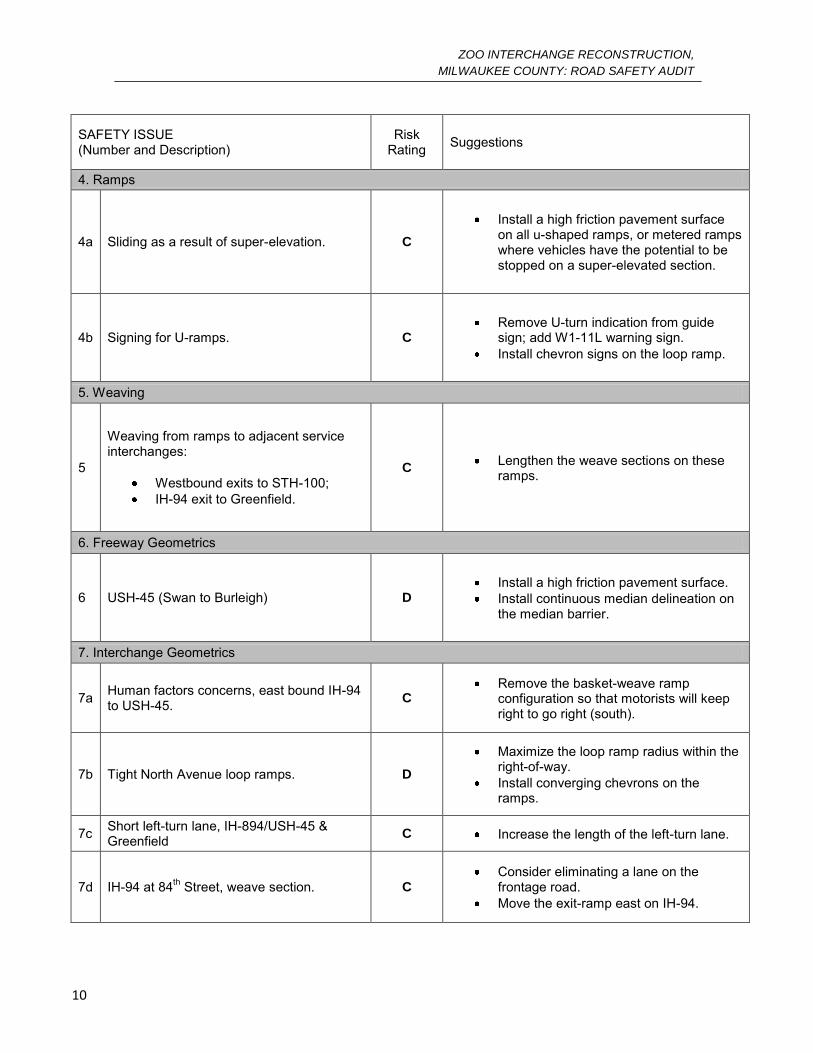
The seventeen main issues and their suggested alternatives are described in detail in Section 5 (Issues
and Suggestions) and are summarized in TABLE 2.1 below.
ZOO INTERCHANGE RECONSTRUCTION,
MILWAUKEE COUNTY: ROAD SAFETY AUDIT
9
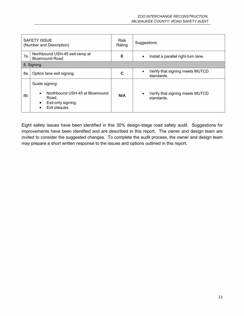
Table 2-1 SUMMARY OF RSA SAFETY ISSUES AND SUGGESTIONS
SAFETY ISSUE (Number and Description)
Risk Rating Suggestions
1. Non-motorized Road Users
1a Non-motorized road users crossing at free-flow loop ramps. E
Install pedestrian/bicycle crossing signs and warning beacons in combination with rapid-flashing beacons at crosswalks.
1b Non-motorized road users crossing channelized right turn lanes. E
Convert all 45º/45º/90º pork-chop islands to 30º/60º/90º pork-chop islands.
1c Bike lanes on STH-100. F
Reconsider installing bicycle lanes on STH-100.
Provide a shared use path for bicycles and pedestrians set back from the roadway.
2. Access Management
2
Bi-directional median openings:
STH-100 south of Watertown Plank Road;
Bluemound Road east of STH-100. Wheaton-Franciscan Hospital
E
Directionalize the median openings. Consider signalizing the median opening
for u-turn movements at the Wheaton-Franciscan Hospital, or adding a signalized median opening south of the hospital and north of the interchange ramp.
3. Signalized Intersections
3a Triple-left-turn movements. D Install illuminated raised pavement
markings to better delineate turn-paths.
3b
Negatively-offset left-turns:
Bluemound Road west of Glenview;
STH-100 at Wisconsin Avenue.
D Consider incorporating positively off-set
left-turn lanes at these intersections, or protected signal phasing.
ZOO INTERCHANGE RECONSTRUCTION,
MILWAUKEE COUNTY: ROAD SAFETY AUDIT
10
SAFETY ISSUE (Number and Description)
Risk Rating Suggestions
4. Ramps
4a Sliding as a result of super-elevation. C
Install a high friction pavement surface on all u-shaped ramps, or metered ramps where vehicles have the potential to be stopped on a super-elevated section.
4b Signing for U-ramps. C Remove U-turn indication from guide
sign; add W1-11L warning sign. Install chevron signs on the loop ramp.
5. Weaving
5
Weaving from ramps to adjacent service interchanges:
Westbound exits to STH-100; IH-94 exit to Greenfield.
C Lengthen the weave sections on these
ramps.
6. Freeway Geometrics
6 USH-45 (Swan to Burleigh) D Install a high friction pavement surface. Install continuous median delineation on
the median barrier.
7. Interchange Geometrics
7a Human factors concerns, east bound IH-94 to USH-45. C
Remove the basket-weave ramp configuration so that motorists will keep right to go right (south).
7b Tight North Avenue loop ramps. D
Maximize the loop ramp radius within the right-of-way.
Install converging chevrons on the ramps.
7c Short left-turn lane, IH-894/USH-45 & Greenfield C Increase the length of the left-turn lane.
7d IH-94 at 84th Street, weave section. C Consider eliminating a lane on the
frontage road. Move the exit-ramp east on IH-94.
ZOO INTERCHANGE RECONSTRUCTION,
MILWAUKEE COUNTY: ROAD SAFETY AUDIT
11
SAFETY ISSUE (Number and Description)
Risk Rating Suggestions
7e Northbound USH-45 exit-ramp at Bluemound Road. E Install a parallel right-turn lane.
8. Signing
8a Option lane exit signing. C Verify that signing meets MUTCD
standards.
8b
Guide signing:
Northbound USH-45 at Bluemound Road;
Exit-only signing; Exit plaques.
N/A Verify that signing meets MUTCD
standards.
Eight safety issues have been identified in this 30% design-stage road safety audit. Suggestions for improvements have been identified and are described in this report. The owner and design team are invited to consider the suggested changes. To complete the audit process, the owner and design team may prepare a short written response to the issues and options outlined in this report.
ZOO INTERCHANGE RECONSTRUCTION,
MILWAUKEE COUNTY: ROAD SAFETY AUDIT
12
3.0 ROAD SAFETY AUDIT TEAM AND MATERIALS
Project: Zoo Interchange Reconstruction, Milwaukee County, Wisconsin
RSA Team Members:
Jeffrey Bagdade, P.E.
Andrew Ceifetz, P.E.
Margaret Myers
Opus International Consultants
Opus International Consultants
Opus International Consultants
Project Owner: Wisconsin Department of Transportation
Design Team: Forward 45
Review Stage: Planning / Preliminary Design Stage (30%)
Start Up Meeting: October 10, 2011
Preliminary Findings
Meeting: October 13, 2011
Attended by:
Wisconsin Department of Transportation (Owner)
Opus International Consultants (RSA Team)
Forward 45 (Design Team)
Federal Highway Administration
Provided Input:
Stacey Pierce, P.E – Wisconsin Department of Transportation
Milwaukee County Sherriff
Wisconsin State Police
Project Documents Available for the Audit:
The RSA team primarily reviewed the updated “Reduced Impacts Alternative” plan drawings of the proposed design, showing proposed lane configurations and interchange configurations. Several planning-level alternatives for the Zoo Interchange Reconstruction Project were provided for review by the RSA team. Early preliminary design drawings at the 30% complete stage were also available. Background reports and documents available as of October 1, 2011 were also provided to the RSA Team. Upon arrival, a 3-D model of the study location was also provided by WisDOT.
ZOO INTERCHANGE RECONSTRUCTION,
MILWAUKEE COUNTY: ROAD SAFETY AUDIT
13
4.0 SITE VISIT NOTES
Project Name: Zoo Interchange Reconstruction: Milwaukee County
Site Visit Dates: October 10-12: The Road Safety Audit Team took a driving tour of the project area.
Land Uses
IH-94, IH-894, and USH-45 are located in the Milwaukee area. Adjacent land uses are residential, industrial, and commercial areas in the cities of Milwaukee, West Allis, Wauwatosa, Elm Grove and Brookfield. Included in the existing and future land uses are a large medical campus and popular retail shopping mall. The Milwaukee County Zoo and Wisconsin State Fair Grounds are located within the study area. Miller Park is located near the eastern limit of the project. Significant growth is expected in the northern section of the project area due to the expansion of the Milwaukee County Grounds and the University of Wisconsin-Milwaukee. The Milwaukee Regional Medical Center is located on Watertown Plank Road.
Road User Characteristics
Moderate traffic was observed at the time (mid morning) of the driving tour including a larger proportion of trucks due to the surrounding industrial areas. At the time of the tour, rush hour traffic had begun to decrease to non-peak levels, but in discussion with the design team, the project area sees substantial traffic during rush hours. Significant traffic congestion has been forecasted for the year 2035.
Road and Roadside Physical Characteristics
All of the freeways in the project area have six-lane divided cross sections. A short segment which consists of a four-lane divided cross section is proposed through the core of the Zoo Interchange on IH-94. The study sections of IH-94, IH-894, and USH-45 all accommodate entering and exiting traffic using various interchange designs consisting of diamond and partial cloverleaf interchanges. The on and off ramps consist of horizontal curves and loop ramps. The posted speed limit through the project limits is 55 mph on the freeway sections. The east and south leg of the interchange project area is relatively straight with gradual horizontal curves right before the project limits on each leg. The west legs consist of multiple gradual horizontal curves. The north leg, the longest leg, consists of multiple horizontal and vertical compound curves.
Adjacent Network and Connectivity:
IH-94 connects USH-45 and IH-894 with the City of Milwaukee and the Marquette Interchange (to the east); and Waukesha County and Madison (to the west). USH-45 and IH-894 connect IH-94 to the communities of suburban Washington County, the Fox Valley and Green Bay (to the north) and to Chicago and Beloit (to the south). The Zoo Interchange is used by local commuters as well as visitors to the Milwaukee Zoo and the Wisconsin State Fair Grounds.
ZOO INTERCHANGE RECONSTRUCTION,
MILWAUKEE COUNTY: ROAD SAFETY AUDIT
14
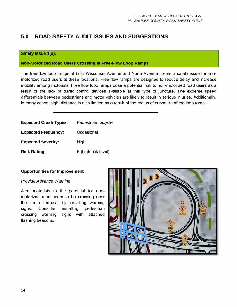
5.0 ROAD SAFETY AUDIT ISSUES AND SUGGESTIONS
Safety Issue 1(a):
Non-Motorized Road Users Crossing at Free-Flow Loop Ramps
The free-flow loop ramps at both Wisconsin Avenue and North Avenue create a safety issue for non-motorized road users at these locations. Free-flow ramps are designed to reduce delay and increase mobility among motorists. Free flow loop ramps pose a potential risk to non-motorized road users as a result of the lack of traffic control devices available at this type of juncture. The extreme speed differentials between pedestrians and motor vehicles are likely to result in serious injuries. Additionally, in many cases, sight distance is also limited as a result of the radius of curvature of the loop ramp.
Expected Crash Types: Pedestrian, bicycle
Expected Frequency: Occasional
Expected Severity: High
Risk Rating: E (high risk level)
Opportunities for Improvement
Provide Advance Warning
Alert motorists to the potential for non-motorized road users to be crossing near the ramp terminal by installing warning signs. Consider installing pedestrian crossing warning signs with attached flashing beacons.
ZOO INTERCHANGE RECONSTRUCTION,
MILWAUKEE COUNTY: ROAD SAFETY AUDIT
15
Safety Issue 1(b):
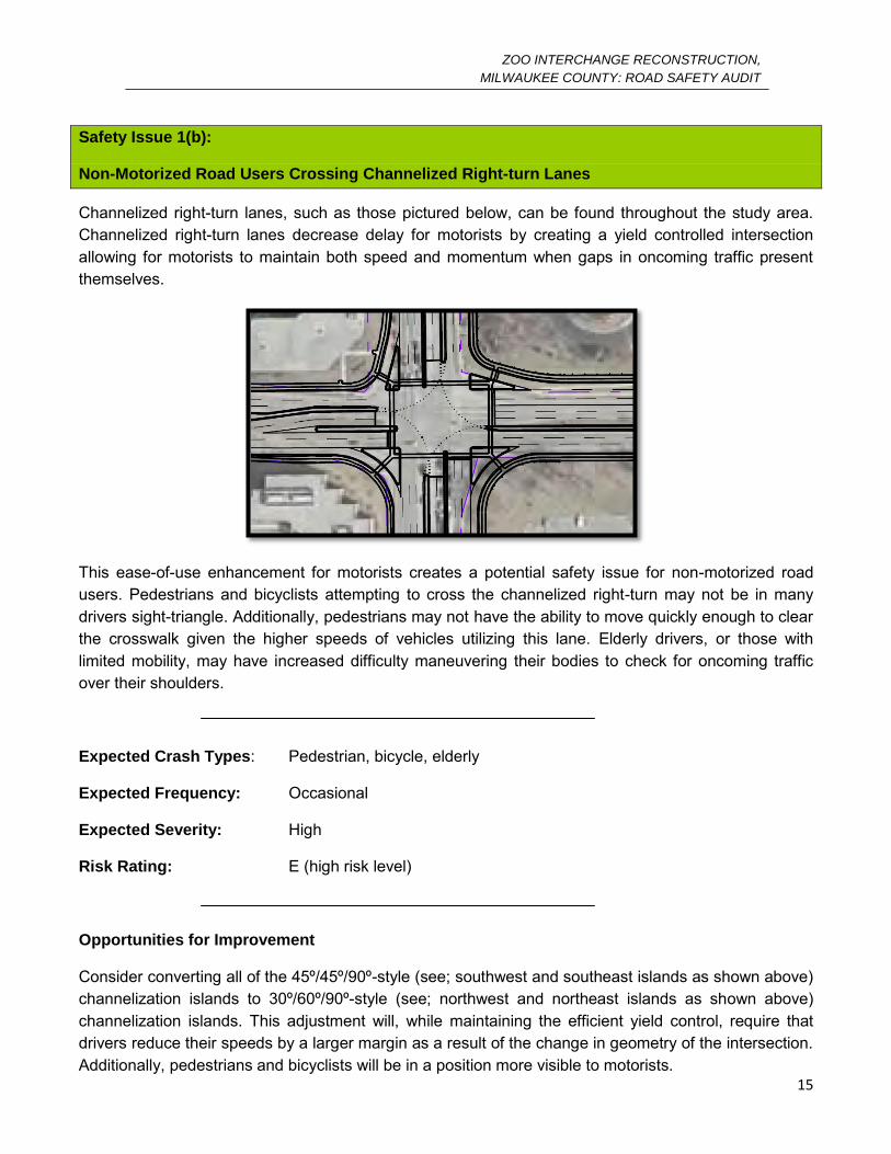
Non-Motorized Road Users Crossing Channelized Right-turn Lanes
Channelized right-turn lanes, such as those pictured below, can be found throughout the study area. Channelized right-turn lanes decrease delay for motorists by creating a yield controlled intersection allowing for motorists to maintain both speed and momentum when gaps in oncoming traffic present themselves.
This ease-of-use enhancement for motorists creates a potential safety issue for non-motorized road users. Pedestrians and bicyclists attempting to cross the channelized right-turn may not be in many drivers sight-triangle. Additionally, pedestrians may not have the ability to move quickly enough to clear the crosswalk given the higher speeds of vehicles utilizing this lane. Elderly drivers, or those with limited mobility, may have increased difficulty maneuvering their bodies to check for oncoming traffic over their shoulders.
Expected Crash Types: Pedestrian, bicycle, elderly
Expected Frequency: Occasional
Expected Severity: High
Risk Rating: E (high risk level)
Opportunities for Improvement
Consider converting all of the 45º/45º/90º-style (see; southwest and southeast islands as shown above) channelization islands to 30º/60º/90º-style (see; northwest and northeast islands as shown above) channelization islands. This adjustment will, while maintaining the efficient yield control, require that drivers reduce their speeds by a larger margin as a result of the change in geometry of the intersection. Additionally, pedestrians and bicyclists will be in a position more visible to motorists.

ZOO INTERCHANGE RECONSTRUCTION,
MILWAUKEE COUNTY: ROAD SAFETY AUDIT
16
Safety Issue 1(c):
Bike Lanes on STH-100
The Reduced Impacts Alternative design proposes a bicycle lane into the plan for STH-100 between IH-94 and Watertown Plank Road. Given the projected traffic volumes and the current 45 M.P.H. speed limit on this roadway, the potential for serious bicycle/motorized vehicle interaction to occur is high.
Expected Crash Types: Bicycle
Expected Frequency: Frequent
Expected Severity: High
Risk Rating: F (extreme risk level)
Opportunities for Improvement:
Relocate bicycles
Consider revising the Reduced Impacts Alternative design to remove the proposed bicycle lanes from STH-100. An alternative may be to create a shared-use path where-in both bicyclists and pedestrians can share a single space set back from the roadway. A shared use path is a safer alternative to and in-road lane as the potential speed differentials between a bicyclist and a pedestrian are likely to result in less-severe injuries. Removing bicyclists from the shoulder will significantly reduce the likelihood of serious bicycle/motor-vehicle interactions occurring.
ZOO INTERCHANGE RECONSTRUCTION,
MILWAUKEE COUNTY: ROAD SAFETY AUDIT
17
Safety Issue 2 Description:
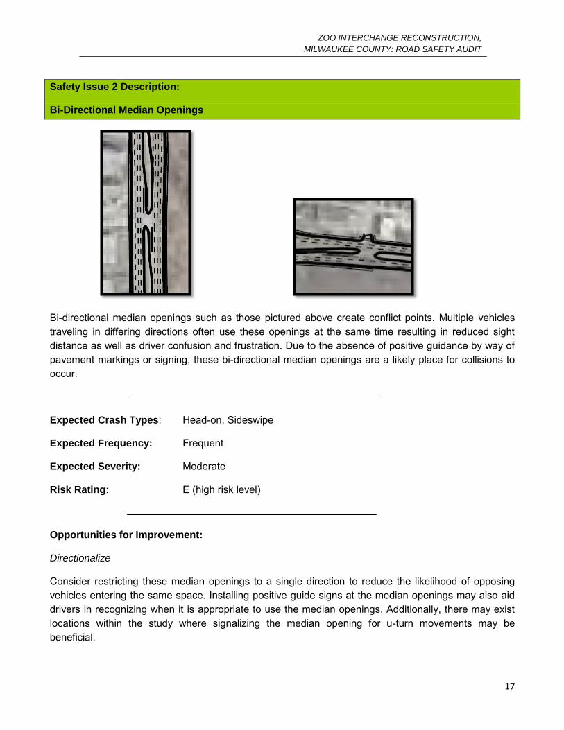
Bi-Directional Median Openings
Bi-directional median openings such as those pictured above create conflict points. Multiple vehicles traveling in differing directions often use these openings at the same time resulting in reduced sight distance as well as driver confusion and frustration. Due to the absence of positive guidance by way of pavement markings or signing, these bi-directional median openings are a likely place for collisions to occur.
Expected Crash Types: Head-on, Sideswipe
Expected Frequency: Frequent
Expected Severity: Moderate
Risk Rating: E (high risk level)
Opportunities for Improvement:
Directionalize
Consider restricting these median openings to a single direction to reduce the likelihood of opposing vehicles entering the same space. Installing positive guide signs at the median openings may also aid drivers in recognizing when it is appropriate to use the median openings. Additionally, there may exist locations within the study where signalizing the median opening for u-turn movements may be beneficial.

ZOO INTERCHANGE RECONSTRUCTION,
MILWAUKEE COUNTY: ROAD SAFETY AUDIT
18
Safety Issue 3(a) Description:
Triple-Left-Turn Movements
The Reduced Impacts Alternative Design incorporates triple-left turn lanes in order to accommodate the projected traffic volumes at the two intersections of STH-100 and Bluemound Road and Swan Boulevard and Watertown Plank Road. Triple-left turn movements may be difficult for many motorists to negotiate within their lane assignment leading to an increase in sideswipe crashes.
Expected Crash Types: Sideswipe
Expected Frequency: Frequent
Expected Severity: Low
Risk Rating: D (significant risk level)
Opportunities for Improvement
Delineate
Consider installing illuminated, raised, pavement markers to better delineate turn-paths. These illuminated pavement markers will be activated only during the left-turn phase associated with the pavement markings. It is important to note that the raised nature of the delineators may pose a problem for snow removal in the winter months. An example of these illuminated pavement markers can be seen below.
ZOO INTERCHANGE RECONSTRUCTION,
MILWAUKEE COUNTY: ROAD SAFETY AUDIT
19
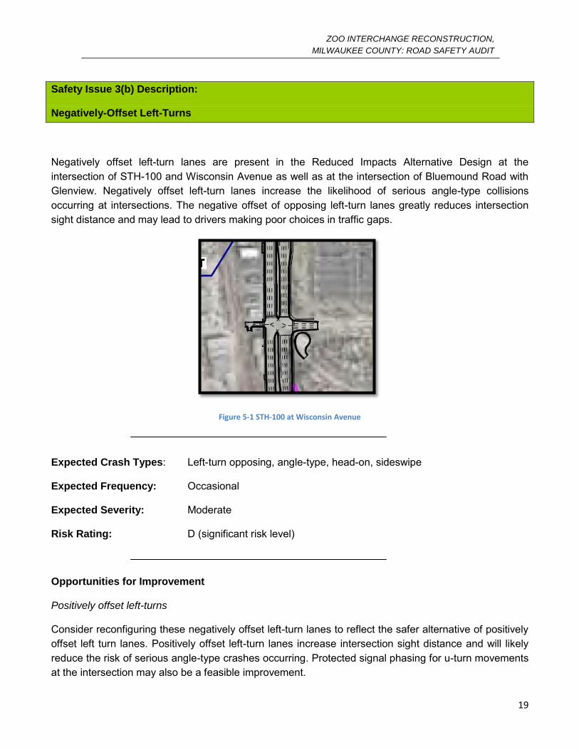
Safety Issue 3(b) Description:
Negatively-Offset Left-Turns
Negatively offset left-turn lanes are present in the Reduced Impacts Alternative Design at the intersection of STH-100 and Wisconsin Avenue as well as at the intersection of Bluemound Road with Glenview. Negatively offset left-turn lanes increase the likelihood of serious angle-type collisions occurring at intersections. The negative offset of opposing left-turn lanes greatly reduces intersection sight distance and may lead to drivers making poor choices in traffic gaps.
Figure 5-1 STH-100 at Wisconsin Avenue
Expected Crash Types: Left-turn opposing, angle-type, head-on, sideswipe
Expected Frequency: Occasional
Expected Severity: Moderate
Risk Rating: D (significant risk level)
Opportunities for Improvement
Positively offset left-turns
Consider reconfiguring these negatively offset left-turn lanes to reflect the safer alternative of positively offset left turn lanes. Positively offset left-turn lanes increase intersection sight distance and will likely reduce the risk of serious angle-type crashes occurring. Protected signal phasing for u-turn movements at the intersection may also be a feasible improvement.
ZOO INTERCHANGE RECONSTRUCTION,
MILWAUKEE COUNTY: ROAD SAFETY AUDIT
20
Safety Issue 4(a):
Sliding Due to Super-Elevation
Sliding as a result of the super-elevation of the U-shaped ramps at the intersection of USH-45 and Watertown Plank Road as well at the interchange of STH-100 and IH-94 is a concern during inclement wet or winter weather. Sliding on these ramps could result in loss of control, roll-over, and sideswipe collisions.
Expected Crash Types: Sideswipe, run-off-road, roll-over
Expected Frequency: Occasional
Expected Severity: Low
Risk Rating: C (moderate risk level)
Opportunities for Improvement
Friction Course
It is suggested that a high friction pavement surface be installed on ramps to reduce the risk of sliding under less-than-favorable conditions.
ZOO INTERCHANGE RECONSTRUCTION,
MILWAUKEE COUNTY: ROAD SAFETY AUDIT
21
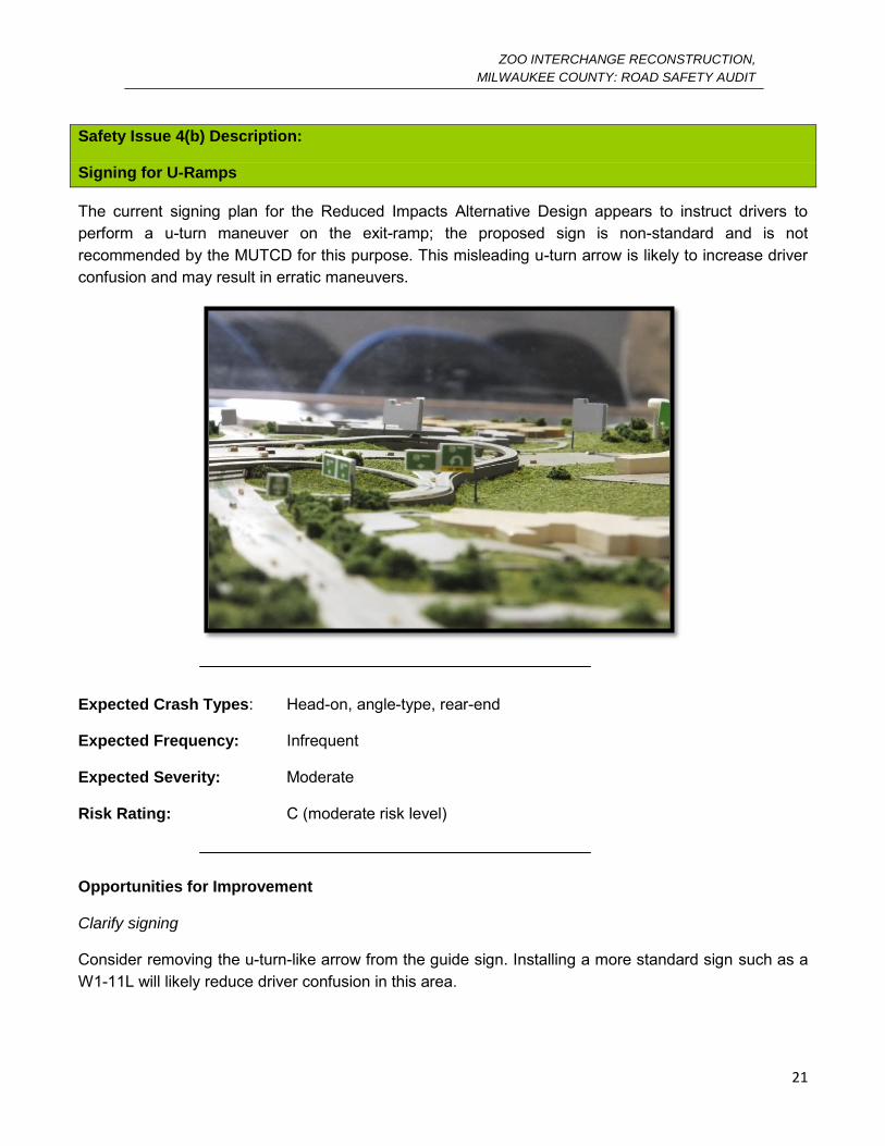
Safety Issue 4(b) Description:
Signing for U-Ramps
The current signing plan for the Reduced Impacts Alternative Design appears to instruct drivers to perform a u-turn maneuver on the exit-ramp; the proposed sign is non-standard and is not recommended by the MUTCD for this purpose. This misleading u-turn arrow is likely to increase driver confusion and may result in erratic maneuvers.
Expected Crash Types: Head-on, angle-type, rear-end
Expected Frequency: Infrequent
Expected Severity: Moderate
Risk Rating: C (moderate risk level)
Opportunities for Improvement
Clarify signing
Consider removing the u-turn-like arrow from the guide sign. Installing a more standard sign such as a W1-11L will likely reduce driver confusion in this area.
ZOO INTERCHANGE RECONSTRUCTION,
MILWAUKEE COUNTY: ROAD SAFETY AUDIT
22
Safety Issue 5:
Weaving
Traffic slowing to make the transition from the westbound IH-94 exit-ramps to STH-100 must merge with faster moving vehicles preparing to merge onto IH-94 from southbound USH-45 in a very short merge section. Additionally, IH-94 traffic exiting to Greenfield Road must merge with traffic from the frontage road in a short section of roadway.
These short merge sections in combination with speed differentials result in a reduced decision sight distance and increased weaving maneuvers.
Expected Crash Types: Weaving, rear-end collisions
Expected Frequency: Occasional
Expected Severity: Low
Risk Rating: C (moderate risk level)
Opportunities for Improvement
Consider lengthening these merge distances. Increasing the segment length will reduce the amount of weaving and high speed differentials which are expected to occur. Furthermore, this will likely reduce driver confusion and frustration and likely increase the decision sight distance through this segment.
ZOO INTERCHANGE RECONSTRUCTION,
MILWAUKEE COUNTY: ROAD SAFETY AUDIT
23
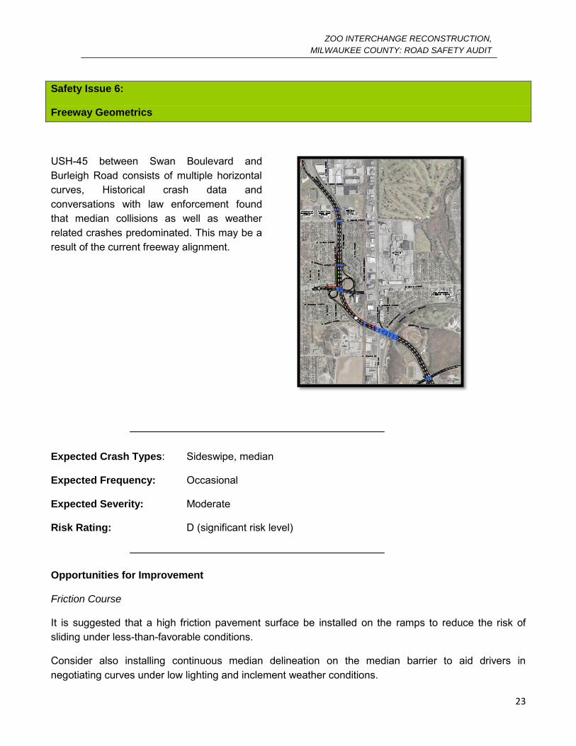
Safety Issue 6:
Freeway Geometrics
USH-45 between Swan Boulevard and Burleigh Road consists of multiple horizontal curves, Historical crash data and conversations with law enforcement found that median collisions as well as weather related crashes predominated. This may be a result of the current freeway alignment.
Expected Crash Types: Sideswipe, median
Expected Frequency: Occasional
Expected Severity: Moderate
Risk Rating: D (significant risk level)
Opportunities for Improvement
Friction Course
It is suggested that a high friction pavement surface be installed on the ramps to reduce the risk of sliding under less-than-favorable conditions.
Consider also installing continuous median delineation on the median barrier to aid drivers in negotiating curves under low lighting and inclement weather conditions.
ZOO INTERCHANGE RECONSTRUCTION,
MILWAUKEE COUNTY: ROAD SAFETY AUDIT
24
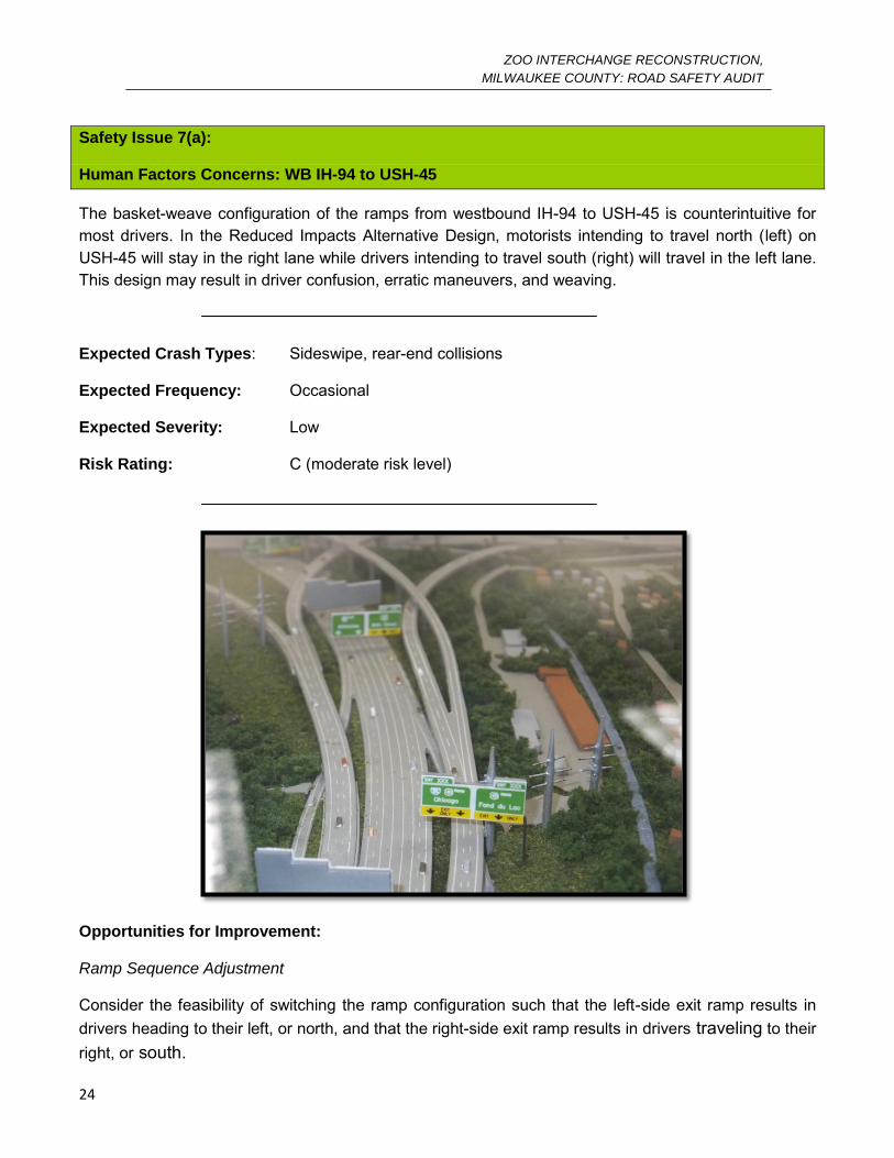
Safety Issue 7(a):
Human Factors Concerns: WB IH-94 to USH-45
The basket-weave configuration of the ramps from westbound IH-94 to USH-45 is counterintuitive for most drivers. In the Reduced Impacts Alternative Design, motorists intending to travel north (left) on USH-45 will stay in the right lane while drivers intending to travel south (right) will travel in the left lane. This design may result in driver confusion, erratic maneuvers, and weaving.
Expected Crash Types: Sideswipe, rear-end collisions
Expected Frequency: Occasional
Expected Severity: Low
Risk Rating: C (moderate risk level)
Opportunities for Improvement:
Ramp Sequence Adjustment
Consider the feasibility of switching the ramp configuration such that the left-side exit ramp results in drivers heading to their left, or north, and that the right-side exit ramp results in drivers traveling to their right, or south.
ZOO INTERCHANGE RECONSTRUCTION,
MILWAUKEE COUNTY: ROAD SAFETY AUDIT
25
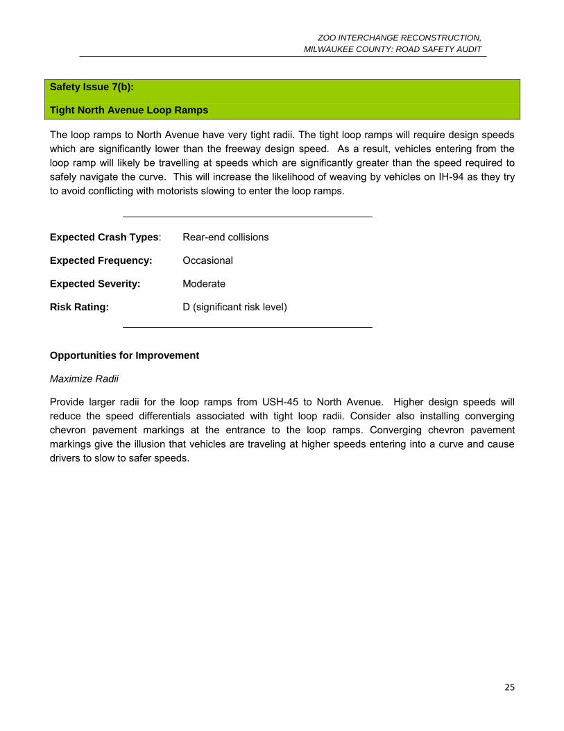
Safety Issue 7(b):
Tight North Avenue Loop Ramps
The loop ramps to North Avenue have very tight radii. The tight loop ramps will require design speeds which are significantly lower than the freeway design speed. As a result, vehicles entering from the loop ramp will likely be travelling at speeds which are significantly greater than the speed required to safely navigate the curve. This will increase the likelihood of weaving by vehicles on IH-94 as they try to avoid conflicting with motorists slowing to enter the loop ramps.
Expected Crash Types: Rear-end collisions
Expected Frequency: Occasional
Expected Severity: Moderate
Risk Rating: D (significant risk level)
Opportunities for Improvement
Maximize Radii
Provide larger radii for the loop ramps from USH-45 to North Avenue. Higher design speeds will reduce the speed differentials associated with tight loop radii. Consider also installing converging chevron pavement markings at the entrance to the loop ramps. Converging chevron pavement markings give the illusion that vehicles are traveling at higher speeds entering into a curve and cause drivers to slow to safer speeds.

ZOO INTERCHANGE RECONSTRUCTION,
MILWAUKEE COUNTY: ROAD SAFETY AUDIT
26
Safety Issue 7(c):
Short Left-Turn Lane, IH-894/USH-45 and Greenfield
The storage provided for left-turn movements from Greenfield Road to IH-894/USH-45 may be inconsistent with the projected demand volumes for the year 2035. The current design will likely lead to the presence of queues, weaving maneuvers, increased driver frustration and red-light running.
Expected Crash Types: Sideswipe, rear-end collisions
Expected Frequency: Occasional
Expected Severity: Low
Risk Rating: C (moderate risk level)
Opportunities for Improvement
Increase Storage
Lengthen the left turn lane to accommodate for more vehicles. This increased storage will reduce the potential for rear-end collisions, and sideswipe crashes by vehicles in neighboring lanes.
ZOO INTERCHANGE RECONSTRUCTION,
MILWAUKEE COUNTY: ROAD SAFETY AUDIT
27
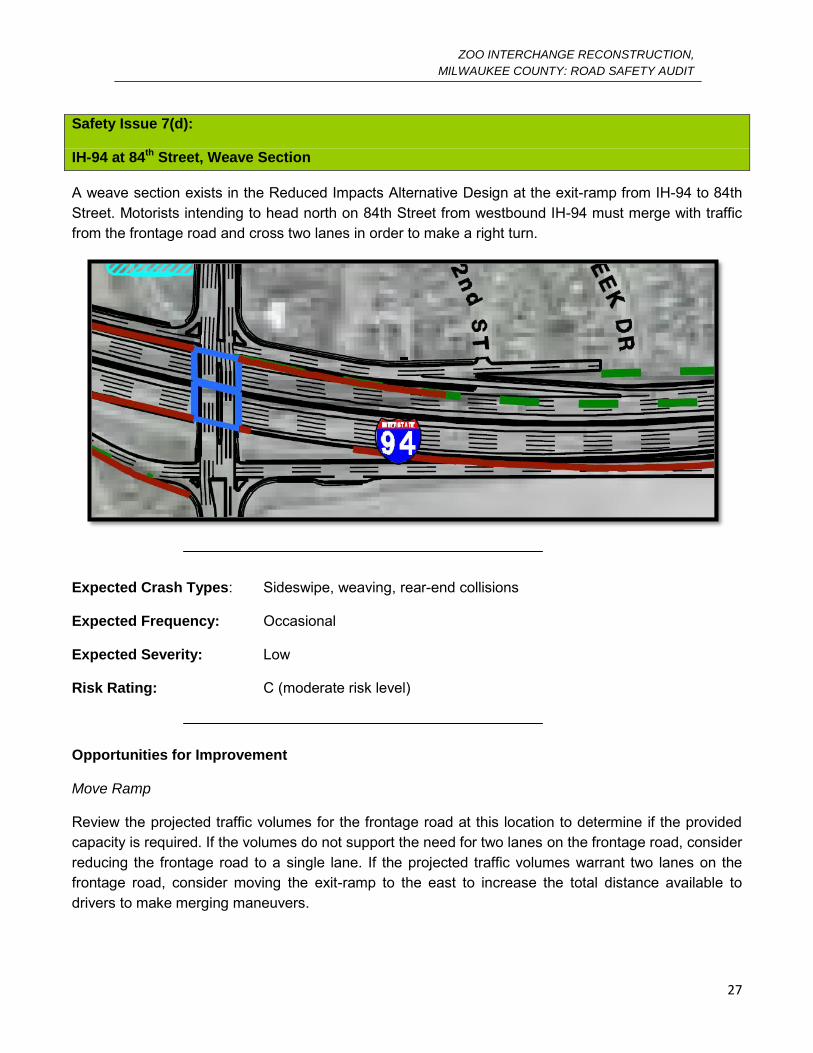
Safety Issue 7(d):
IH-94 at 84th Street, Weave Section
A weave section exists in the Reduced Impacts Alternative Design at the exit-ramp from IH-94 to 84th Street. Motorists intending to head north on 84th Street from westbound IH-94 must merge with traffic from the frontage road and cross two lanes in order to make a right turn.
Expected Crash Types: Sideswipe, weaving, rear-end collisions
Expected Frequency: Occasional
Expected Severity: Low
Risk Rating: C (moderate risk level)
Opportunities for Improvement
Move Ramp
Review the projected traffic volumes for the frontage road at this location to determine if the provided capacity is required. If the volumes do not support the need for two lanes on the frontage road, consider reducing the frontage road to a single lane. If the projected traffic volumes warrant two lanes on the frontage road, consider moving the exit-ramp to the east to increase the total distance available to drivers to make merging maneuvers.
ZOO INTERCHANGE RECONSTRUCTION,
MILWAUKEE COUNTY: ROAD SAFETY AUDIT
28
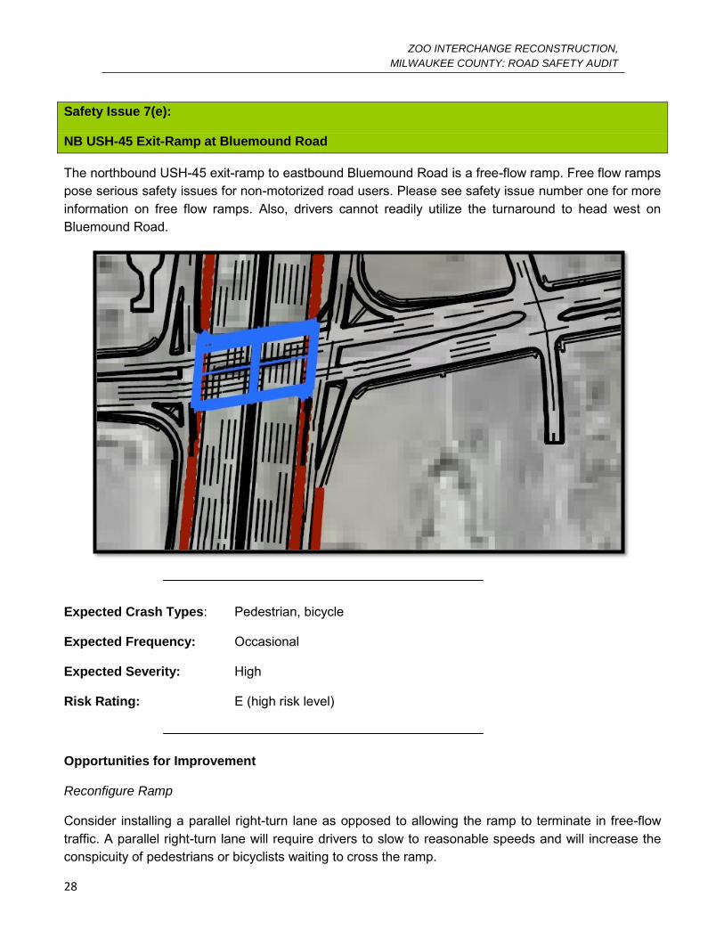
Safety Issue 7(e):
NB USH-45 Exit-Ramp at Bluemound Road
The northbound USH-45 exit-ramp to eastbound Bluemound Road is a free-flow ramp. Free flow ramps pose serious safety issues for non-motorized road users. Please see safety issue number one for more information on free flow ramps. Also, drivers cannot readily utilize the turnaround to head west on Bluemound Road.
Expected Crash Types: Pedestrian, bicycle
Expected Frequency: Occasional
Expected Severity: High
Risk Rating: E (high risk level)
Opportunities for Improvement
Reconfigure Ramp
Consider installing a parallel right-turn lane as opposed to allowing the ramp to terminate in free-flow traffic. A parallel right-turn lane will require drivers to slow to reasonable speeds and will increase the conspicuity of pedestrians or bicyclists waiting to cross the ramp.
ZOO INTERCHANGE RECONSTRUCTION,
MILWAUKEE COUNTY: ROAD SAFETY AUDIT
29
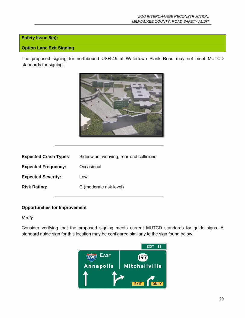
Safety Issue 8(a):
Option Lane Exit Signing
The proposed signing for northbound USH-45 at Watertown Plank Road may not meet MUTCD standards for signing.
Expected Crash Types: Sideswipe, weaving, rear-end collisions
Expected Frequency: Occasional
Expected Severity: Low
Risk Rating: C (moderate risk level)
Opportunities for Improvement
Verify
Consider verifying that the proposed signing meets current MUTCD standards for guide signs. A standard guide sign for this location may be configured similarly to the sign found below.
ZOO INTERCHANGE RECONSTRUCTION,
MILWAUKEE COUNTY: ROAD SAFETY AUDIT
30
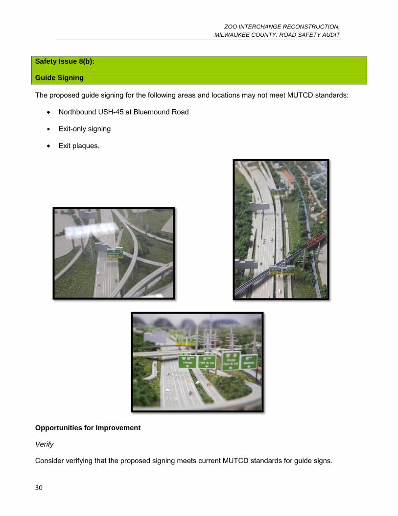
Safety Issue 8(b):
Guide Signing
The proposed guide signing for the following areas and locations may not meet MUTCD standards:
Northbound USH-45 at Bluemound Road
Exit-only signing
Exit plaques.
Opportunities for Improvement
Verify
Consider verifying that the proposed signing meets current MUTCD standards for guide signs.

APPENDIX A
WISDOT RESPONSES
A-1
The following are responses provided to Opus by Chris Hager via e-mail on the 18th of November, 2011.
1a Agree this has been incorporated into our design. It now includes a free flow right turn lane add and has 45
degree islands.
1b Agree this will be incorporated in preliminary design.
1c Trans 75 requires inclusion of ped/bike accommodations. The Zoo Interchange Project Team was required to
include bike lanes by the Statewide Bicycle & Pedestrian Coordinator.
The FDM states that WisDOT and federal policy, state statutes and administrative codes require include bicycle
accommodations on all new construction and reconstruction highway projects. The Wisconsin’s Bicycle Facility
Design Handbook states that the WisDOT recognizes the importance of the bicycle as a legitimate mode of
transportation and for some people the bicycle is their main or only mode to transportation ( page 1-1). State
statute considers bicycles as vehicles and are allowed and expected to be on STH 100.
In the 2011 traffic counts it showed that in a 13 hour period at Watertown Plank Rd. and STH 100, there were a
total of 77 bicyclists going through the intersection. STH 100 is an arterial street where major businesses and
institutions are often located and are destination points for people, including bicyclists. “Common
improvements recommended for arterial streets include: bicycle lanes, wide outside lanes, or shoulders (page 2-
5). The Handbook states that bicycle lanes are the preferred bicycle facility on higher volume urban and
suburban roadways ( i.e. Arterial streets), (page 3-1) Among the benefits of bicycle lanes are providing adequate
width for bicycles which is imperative so that the motorist may pass a bicyclist and stay in the travel lane.
Suggesting that bicyclist use a shared use path through this corridor does not follow design standards. The
Handbook points out that “these paths are a complementary system of off-road transportation routes for
bicycles and others. They should not substitute for on-road bicycle facilities, but rather supplement a system of
on-road bike lanes, wide outside lanes and paved shoulders” (page 4-1) A 2006 bicycle /motor vehicle crash
study showed that 29% of urban crashes reported were sidepath/sidewalk crashes.
2 The full median opening design is at the direction of the department and is in response to stakeholder
input. The department has indicated that this full opening would be closed in the event that safety problem
develops.
3a We will clearly identify channelizing but will also keep it from becoming a maintenance issue. We will include
dotted line tracking through the intersection.
3b These intersections will have protected left turn signal phasing.
4a Standard is 6% max super. We will consider the high friction pavement treatment in final design.
4b The U-ramp signing is not along the mainline of the freeway and does not imply a U-turn movement. The
sign is also located in a position where a U-turn is not possible. The sign provides the driver more information
by being displayed overhead on the guide sign than it would with a W1-11L. We plan to install the chevron signs
on the loop ramp.
5 The weave distances are restricted by right of way implications. Traffic modeling in Paramics and HCS has
demonstrated reasonable operations. Closing the movements would eliminate the weaves but is not an
A-2
acceptable alternative to stakeholders. The W-S ramp to Greenfield Ave. movement is very low volume (less
than 50 vph in the peak). We have studied taking WB movements to STH 100 around the loop and increasing
the number of phases at the intersection with HWY 100. The study concluded the current configuration is
preferred. We have designed the bridges over 94 to accommodate either configuration in the event the weave
becomes an issue.
6 ROW constraints have significant influence on the alignment. We will consider the high friction pavement
treatment in final design. Continuous median delineation will be considered in final design.
7a The configuration would require significant additional ROW in acquiring the zoo maintenance facility. Taking
the zoo maintenance facility is not an option. Signing will address this to the extent possible.
7b Ramp radiuses are maximized given additional residential ROW is not an option. Converging chevrons are
non-compliant with the MUTCD. Transverse markings are an option but have not been extremely effective.
7c They have been lengthened in preliminary design.
7d We can discuss with the City of Milwaukee but O’Conner is heavily used during state fair. We will investigate
further.
7e This is being addressed currently in design.
8a The guide sign plan has been updated and currently meets MUTCD standards.
8b The guide sign plan has been updated and currently meets MUTCD standards.


• Road Safety Engineering
• Transportation Planning
• Traffic Operations
• Transit and Sustainability
• Community and School Safety
• Asset Management