Road drainage and the water environment · drainage and the water environment with consideration...
91
A14 Cambridge to Huntingdon improvement scheme Environmental Statement 6.1 December 2014 17/1 17 Road drainage and the water environment Executive summary This chapter provides an assessment of the likely significant effects of the scheme on drainage and the water environment with consideration for the effects of the construction and operation of the scheme on flood risk, hydromorphology, surface water quality and groundwater. During construction, potential impacts on the water environment would be mitigated through a series of recognised best practice measures to be applied by the contractor, such as containment and de-silting of surface water runoff and implementation of pollution protection controls or timing of works to protect sensitive ecology. A Flood Risk Assessment has been undertaken with consideration for the existing flood risk in the study area and the potential impact of the scheme on that flood risk. Where a potential impact is likely, mitigation measures (including flood compensation areas) have been incorporated into the design of the scheme. With the identified mitigation measures in place, the scheme is likely to have a neutral effect on flood risk in 11 out of 14 watercourse catchments in the area of the scheme. Residual effects, taking account of the proposed mitigation measures, have been assessed to be slight adverse at Ellington Brook, Brampton Brook and the river Great Ouse. There is no significantly increased risk to property at these locations. Potential hydromorphological impacts on water bodies have been identified through a Water Framework Directive compliance assessment and a general assessment of other watercourses, and water features (e.g. lakes). It is anticipated that there would be no deterioration in the ecological status of any of the water bodies within the study area protected under the Water Framework Directive. The residual effects on all watercourses, water bodies and other water features are anticipated to be neutral during the operation of the scheme. Likely effects on surface water quality have been assessed using the Highways Agency water risk assessment tool (HAWRAT). Mitigation for the operational phase would be provided by Sustainable Drainage Systems (SuDS), designed to manage flood risk and improve water quality. With these measures in place effects during scheme operation would range from neutral to slight adverse for all individual watercourses. The scheme would be slightly beneficial to water quality in the river Great Ouse catchment as it would provide attenuation and treatment of road runoff for the existing road network where none currently exists.
-
Upload
nguyenngoc -
Category
Documents
-
view
235 -
download
0
Transcript of Road drainage and the water environment · drainage and the water environment with consideration...
A14 Cambridge to Huntingdon improvement scheme Environmental Statement
6.1 December 2014
17/1
17 Road drainage and the water environment
Executive summary
This chapter provides an assessment of the likely significant effects of the scheme on drainage and the water environment with consideration for the effects of the construction and operation of the scheme on flood risk, hydromorphology, surface water quality and groundwater.
During construction, potential impacts on the water environment would be mitigated through a series of recognised best practice measures to be applied by the contractor, such as containment and de-silting of surface water runoff and implementation of pollution protection controls or timing of works to protect sensitive ecology.
A Flood Risk Assessment has been undertaken with consideration for the existing flood risk in the study area and the potential impact of the scheme on that flood risk. Where a potential impact is likely, mitigation measures (including flood compensation areas) have been incorporated into the design of the scheme. With the identified mitigation measures in place, the scheme is likely to have a neutral effect on flood risk in 11 out of 14 watercourse catchments in the area of the scheme. Residual effects, taking account of the proposed mitigation measures, have been assessed to be slight adverse at Ellington Brook, Brampton Brook and the river Great Ouse. There is no significantly increased risk to property at these locations.
Potential hydromorphological impacts on water bodies have been identified through a Water Framework Directive compliance assessment and a general assessment of other watercourses, and water features (e.g. lakes). It is anticipated that there would be no deterioration in the ecological status of any of the water bodies within the study area protected under the Water Framework Directive. The residual effects on all watercourses, water bodies and other water features are anticipated to be neutral during the operation of the scheme.
Likely effects on surface water quality have been assessed using the Highways Agency water risk assessment tool (HAWRAT). Mitigation for the operational phase would be provided by Sustainable Drainage Systems (SuDS), designed to manage flood risk and improve water quality. With these measures in place effects during scheme operation would range from neutral to slight adverse for all individual watercourses. The scheme would be slightly beneficial to water quality in the river Great Ouse catchment as it would provide attenuation and treatment of road runoff for the existing road network where none currently exists.

A14 Cambridge to Huntingdon improvement scheme Environmental Statement
6.1 December 2014
17/2
Potential impacts on groundwater have also been assessed, including potential dewatering during construction of road cuttings and borrow pits. The residual effects on all groundwater bodies and associated receptors are anticipated to be neutral or slight adverse during construction of the scheme. All potential operational impacts are anticipated to have a neutral effect.
17.1 Introduction
17.1.1 The road drainage and the water environment topic covers potential effects of the construction and operation of the scheme on flood risk, hydromorphology surface water quality and groundwater.
17.1.2 This chapter should be read in conjunction with the following appendices:
Flood Risk Assessment (FRA) (Appendix 17.1);
Highways Agency Water Risk Assessment Tool (HAWRAT) (Appendix 17.2); and
Water Framework Directive (WFD) compliance assessment (Appendix 17.3).
17.1.3 Mitigation is provided by the design of the highway drainage for the A14 which follows the philosophy outlined in the Design Manual for Roads and Bridges Volume 4 (Section 2) Part 3 (HD33/06) (Highways Agency, 2006) and in accordance with government policy on the use of Sustainable Drainage Systems (SuDS).
17.1.4 The design is in accordance with guidance provided in HD45/09 Road Drainage and the Water Environment (DMRB 11) (Highways Agency, 2009), on the assessment and management of the impacts of road projects on flood risk and water quality. The design takes climate change into account.
17.1.5 There has been regular and ongoing dialogue with Environment Agency specialists in hydraulic modelling, Flood Risk Assessment (FRA), planning, water quality, dewatering, Water Framework Directive, geomorphology and groundwater.
17.1.6 Monitoring of the effectiveness of the mitigation strategy for the water environment would be undertaken. This would form part of the Highways Agency Post Opening Project Evaluation (POPE) management procedure at Year 1 and Year 5 following completion. A POPE is undertaken following the opening of a road scheme, to evaluate whether it has had the benefits and impact predicted.
Legislative and policy background
17.1.7 This section covers the key European and UK legislation, national policy drivers and local plan policies relevant to this topic.
European Union and UK legislation
17.1.8 Key pieces of legislation setting the context for this chapter are discussed in turn below.
A14 Cambridge to Huntingdon improvement scheme Environmental Statement
6.1 December 2014
17/3
17.1.9 The Water Framework Directive (WFD) was adopted in 2000 and established a framework for management of water resources throughout the European Union. It is a significant piece of legislation with the overarching objective of enabling all water bodies in Europe to attain ‘Good’ or ‘High’ Ecological Status by 2015. The WFD is implemented in England and Wales by The Water Environment (Water Framework Directive) (England and Wales) Regulations 2003” (SI 3242/2003). The Environment Agency is the competent authority in England responsible for delivering the objectives of the WFD. Any watercourses, groundwater or water features covered under the WFD are referred to as ‘WFD water bodies’. The WFD foresees in its Articles 16 and 17 the following two Daughter Directives:
The Groundwater Daughter Directive 2006/118/EC was adopted in 2006 and updated an existing Groundwater Directive (8068/EEC).
The Priority Substances Directive 2008/105/EC.
17.1.10 Other EU legislation is rationalised under the WFD by replacing other "first wave" Directives, including those concerned with freshwater fish and shellfish. The operative provisions of the Directives are taken over in the WFD, allowing them to be repealed (as from December 2013).
17.1.11 The Department of the Environment, Food and Rural Affairs (Defra) is responsible for all aspects of water policy in England. Management and enforcement of this water policy is the responsibility of the Environment Agency. Relevant UK legislation relating to the water environment is identified below:
The Flood Risk (England and Wales) Regulations 2009;
The Flood and Water Management Act 2010;
The Water Resources Act 1991;
The Environment Act 1995;
The Groundwater (England and Wales) Regulations 2009;
The Control of Pollution (Applications, Appeals and Registers) Regulations 1996 (SI1996/2971);
The Environmental Protection Act 1990;
The Land Drainage Act 1991 and 1994;
The Water Act 2003; and
The Control of Pollution (Consents for Discharge) (Secretary of State Functions) Regulations 1989.

A14 Cambridge to Huntingdon improvement scheme Environmental Statement
6.1 December 2014
17/4
National policy drivers
17.1.12 The National Planning Policy Framework (NPPF) (Department for Communities and Local Government, 2012) and accompanying National Planning Practice Guidance (NPPG) (Department for Communities and Local Government, 2014) came into existence in March 2012 and supersede the former topic based Planning Policy Guidance and Planning Policy Statements. The following NPPF paragraphs are relevant to this topic:
Chapter 10 Meeting the Challenge of Climate Change, Flooding and Coastal Change (Paragraphs 94 and 99 to 104); and
Chapter 11 Conserving and Enhancing the Natural Environment (Paragraph 109).
17.1.13 In England, the requirements of the NPPF are set out in the accompanying practice guidance which provides additional information on development in flood risk areas. The NPPF sets strict tests to protect people and property from flooding.
17.1.14 Under this strategy, areas of land throughout England are designated according to the potential flood risks from rivers or the sea. Definitions of these flood zones are contained within Appendix 17.1.
17.1.15 Any highways and transportation schemes within certain categories of flood zones deemed to be essential infrastructure should pass an ‘exception test’ requiring a development to:
provide wider sustainability benefits to the community that outweigh flood risk; and
be safe for its lifetime, taking into account the vulnerability of its users, without increasing flood risk elsewhere. Where possible, flood risk should be reduced elsewhere.
17.1.16 The Government launched a consultation in December 2013 on its Draft National Networks National Policy Statement. This provides a clear articulation of the overall policy against which the Secretary of State for Transport will make decisions on applications for nationally significant infrastructure projects. This project complies with the requirements set out in the draft policy statement.
Local planning policy
17.1.17 Local planning policies relevant to the water environment have been obtained by consulting with the following:
Cambridge Local Plan 2006 (Policy 3/9, 4/13 and 4/16);
North West Cambridge Action Area Plan (October 2009) (Policy NW2, N24 and NW25);
The Cambridge Local Plan 2014: Proposed Submission (Policy 27, 31 and 32);
South Cambridgeshire Development Control Policies (July 2007) (Policy NE/8 and NE/11);
The South Cambridgeshire Local Plan 2011-2031: Proposed Submission (Policy CC/7 and CC/9);

A14 Cambridge to Huntingdon improvement scheme Environmental Statement
6.1 December 2014
17/5
Huntingdonshire Core Strategy (September 2009) (Policy CS1);
Huntingdon West Area Action Plan (February 2011) (Policy HW9);
Saved policies from the Huntingdonshire Local Plan 1995 and the Local Plan Alteration 2002 (Policy CS8 and CS9); and
Huntingdonshire Draft Local Plan to 2036 (Policy LP1, LP6 and LP15).
Other guidance
17.1.18 Other relevant guidance includes the Environment Agency’s Pollution Prevention Guidelines (PPG) (Environment Agency, 2014a), the Memorandum of Understanding between the Environment Agency and the Highways Agency on Highways Issues (dated November, 2009) and the draft National Policy Statement for National Networks (NN NPS) (Department for Transport, 2013).
17.1.19 The Highways Agency will design its drainage in accordance with national best practice for SuDS as necessary.
17.2 Method of assessment
Study area
17.2.1 The study area for flood risk, hydromorphology and water quality is defined as within 1km of the land required for the scheme (the development consent order boundary), both upstream and downstream. However, the study area is expanded as necessary to gather all relevant information.
17.2.2 Within this overall study area, the hydrogeological study area is specifically defined as a 500m radius around the DCO boundary.
Approach to data collection
17.2.3 The following key sources of information have been used in the assessment:
General
previous assessments of the scheme including studies based on DMRB guidance for route options appraisal (Atkins, 2013); and
Environment Agency and Government websites including information on environmentally sensitive areas and historic data (Defra, 2014; Environment Agency 2014b).
Flooding risk
A full schedule of data pertaining specifically to flood risk utilised in the flood risk assessment is listed in Appendix 17.1;
Environment Agency flood maps (Environment Agency, 2014b);
Highways Agency Drainage Data Management System (HADDMS) for specific information on local flood issues; Ellington to Fen Ditton Phase 1a Flood Risk Assessment, (Atkins/Highways Agency, July 2009);
Ellington to Fen Ditton Phase 1a Hydraulic Modelling Report, (Atkins/Highways Agency, July 2009);
Award Drain information (Huntingdonshire District Council 2014; Bedford Group of Inland Drainage Boards, 2014; South Cambridgeshire District Council, 2014);
A14 Cambridge to Huntingdon improvement scheme Environmental Statement
6.1 December 2014
17/6
Flood Risk Assessments (Huntingdonshire District Council, 2010; South Cambridgeshire District Council & Cambridge City Council, 2010), Surface Water Management Plans (Cambridge County Council, 2011) and Catchment Flood Management Plans (Environment Agency, 2011); and
Hydraulic models provided by the Environment Agency in June 2014.
Surface water
Water quality data collected in 2007 as part of the previous scheme;
National River Flow Archive data on the website of the Centre for Ecology and Hydrology; and
Readily available information from the Environment Agency (Environment Agency, 2014b; Environment Agency, 2009).
Groundwater
Information on geology and contaminated land (reported in Chapter 12, BGS, 2014; Environment Agency 2013c; Environment Agency, 2014b);
Previous ground investigation and groundwater monitoring undertaken for this project (Costain, 2009a; Costain, 2009b); and
Landmark Envirocheck Report (2013).
Approach to assessment
17.2.4 This assessment has been carried out in accordance with the Design Manual for Roads and Bridges (DMRB) (2009), Volume 11: Environmental Assessment, Section 3: Environmental Assessment Techniques, HD45/09: Road Drainage and the Water Environment (Highways Agency, 2009). The specific methods used assess potential impacts on flows and flooding and water quality (both surface and groundwater).
17.2.5 Reference has also been made to the Design Manual for Roads and Bridges (DMRB) (2008), Volume 11: Environmental Assessment, Section 2: Environmental Impact Assessment, HD205/08 (Highways Agency, 2008): Assessment and Management of Environmental Effects for guidance on the assessment of impacts from the construction stage of the scheme.
17.2.6 Consultation with the Environment Agency has been undertaken over specific methods and approaches (in December 2013 and again in June, July and August 2014) to fully clarify and agree the scope of the assessment. A wide range of data and information has been gathered and modelling undertaken.
17.2.7 The assessment has also included investigations to make sure that local abstractions are not affected by the road discharges.

A14 Cambridge to Huntingdon improvement scheme Environmental Statement
6.1 December 2014
17/7
17.2.8 At this preliminary design stage of the scheme, the assessment of likely construction impacts has been based upon the information provided within Appendix 3.2. For the purposes of this assessment, a likely worst case scenario has been taken as assuming construction would be carried out concurrently across the scheme. This is a reasonable assumption for this assessment because it does not change the overall assessment of effects. The baseline year of 2016 remains relevant across the construction programme, including section 6 which would not commence until the new route was operational, because the assessed conditions are not expected to change over the duration of the programme as presented in Appendix 3.2.
Flood risk and drainage
17.2.9 Flood risk on watercourses is managed by a number of bodies. The Environment Agency has permissive powers, but no duty to carry out or regulate flood risk management works on main rivers. Local Authorities (Huntingdon District Council, South Cambridgeshire District Council and Cambridgeshire County Council) have the same permissive powers to undertake and regulate flood management on Award Drains awarded for their maintenance. Works on ordinary watercourses are consented by the lead local flood authority (LLFA): Cambridgeshire County Council.
17.2.10 An internal drainage board (IDB) is an authority established in England and Wales where there is a special drainage need. IDBs have permissive powers to undertake works to secure clean water drainage and water level management within the catchment area. The specific drains that form these catchments are known as IDB drains.
17.2.11 Due to the geographical extent of the scheme there are multiple drainage authorities concerned with regulation of the watercourses within the study area. These include:
The Environment Agency (also a navigation authority for the river Great Ouse);
Alconbury and Ellington Internal Drainage Board (part of the Bedford Group of Internal Drainage Boards);
Swavesey Internal Drainage Board;
Huntingdonshire District Council;
South Cambridgeshire District Council; and
Cambridgeshire County Council (who are the lead local flood authority).
17.2.12 The river Great Ouse is a navigable waterway. No canals would be affected by the scheme.
17.2.13 A FRA has been developed in line with the NPPF and is included as Appendix 17.1. The FRA covers:
a review of the existing flood risk;
an assessment of the ‘importance’, ‘magnitude’ and ‘attribute’ of flood risk (as defined in HD45/09 DMRB);
an assessment of the potential impact of the scheme;
details of proposed mitigation measures;

A14 Cambridge to Huntingdon improvement scheme Environmental Statement
6.1 December 2014
17/8
an assessment of the significance of effects of the scheme; and
an assessment of the ‘Sequential’ and ‘Exception Tests’ in accordance with the NPPF.
17.2.14 An allowance for the impact of climate change has been included in the preliminary design of the scheme in accordance with the Environment Agency document: Climate Change Allowance for Planners (Environment Agency, 2013a). This stipulates the adoption of an uplift factor of plus 20% for peak flows and rainfall intensity for the year 2080 and beyond, guided by the output of the UK Climate Projections 2009 (UKCP09).
17.2.15 In England and Wales, The Water Resources Act 1991 (as amended) and the Environment Act 1995 established the Environment Agency’s powers and duties for the protection of water resources, flood defence, fisheries, recreation, conservation and navigation. The Environment Agency is a key statutory consultee responsible for ensuring that a scheme does not adversely affect flood risk, water quality or the local water environment.
17.2.16 Liaison has been undertaken with the Environment Agency, Internal Drainage Boards, local authorities and the Lead Local Flood Authority to seek and discuss their requirements and their views on the design proposals. This information has been considered when developing the scheme design and has influenced the flood risk mitigation measures.
Surface water hydromorphology and Water Framework Directive
17.2.17 A hydromorphological screening assessment has been undertaken on the watercourses along the scheme footprint, primarily the WFD water bodies and their upstream watercourse inputs. This comprises:
a desk study providing information on the catchment area and surrounding land use including historical channel change; and
a geomorphological walkover assessment to investigate the hydrology, geomorphology (i.e. physical features in the channel), sediment inputs and any aspects likely to impact water quality.
17.2.18 A WFD Compliance Assessment has subsequently been completed to determine the potential effects of the scheme on the designated water bodies. This supports the impact assessment and mitigation requirements for the seven WFD water bodies (see Figure 17.1) that would potentially be directly affected by the scheme. The WFD Compliance Assessment (Appendix 17.3) assesses potential effects on biological, physico-chemical and hydromorphological quality elements.
17.2.19 The following activities have been completed to inform the WFD Compliance Assessment:
a walkover assessment to investigate the flow and morphology of the water bodies;
a field survey to collect biological quality data (such as data on fish and macroinvertebrates); and
compilation of water quality data (including HAWRAT outputs).

A14 Cambridge to Huntingdon improvement scheme Environmental Statement
6.1 December 2014
17/9
17.2.20 An assessment of likely effects on other water environment features including lakes, gravel pits and smaller watercourses, has been included within this chapter. This was primarily based on desk study information (detailed in Section 17.3), with receptors scoped out of the assessment where appropriate in the impact assessment (Section 17.4). It is important to understand how impacts on water features affect downstream receiving WFD water bodies.
Surface water quality
17.2.21 Surface water quality has been assessed using the HAWRAT tool in accordance with the DMRB HD45/09 (Highways Agency et al., 2009), specifically:
Method A - Effects of routine runoff on surface waters; and
Method D - Pollution impacts from accidental spillages.
Method A – effects of routine runoff on surface waters
Effects of routine runoff - HAWRAT assessment
17.2.22 The Method A assessment (assessing effects of routine runoff on surface waters) was undertaken using the HAWRAT tool (Appendix 17.2). Full details of the HAWRAT procedure can be found in Appendix 17.2. HAWRAT adopts a tiered approach as follows:
Step 1: Runoff quality – The tool predicts concentrations of pollutants in untreated and undiluted highway runoff prior to any treatment and dilution in a water body.
Step 2: In-river impacts – The tool predicts concentrations of pollutants after mixing within the receiving water body.
Step 3: In-river impacts with mitigation – In Step 3, the tool takes into account mitigation in the form of Sustainable Drainage Systems (e.g. attenuation ponds).
17.2.23 The study area for the HAWRAT assessment encompasses all the watercourses that would be likely to receive road runoff from the scheme. There are 78 proposed outfalls which would discharge into more than 20 watercourses. These are shown on Figure 17.4. All outfalls and receiving watercourses have been assessed individually using the HAWRAT tool.
Cumulative assessment within HAWRAT
17.2.24 In accordance with DMRB guidance, the impact on water quality of the discharges from all outfalls along a river stretch within 1km of the DCO boundary for the scheme have been assessed in combination for soluble pollutants, and within 100m of the DCO boundary for sediment-bound pollutants. Full details of the cumulative assessment methodology within HAWRAT can be found in Appendix 17.2.

A14 Cambridge to Huntingdon improvement scheme Environmental Statement
6.1 December 2014
17/10
Environmental quality standards within HAWRAT
17.2.25 To complete the water quality assessment process, the long-term risks to the ecology of the receiving watercourses have also been appraised. The HAWRAT method requires the estimation of in-river annual average concentrations for dissolved copper and dissolved zinc, including a contribution from road runoff. These concentrations are then compared with published environmental quality standards (EQS) values to assess whether there would be likely to be a long-term impact on ecology, as described in DMRB HD45/09 guidance (Highways Agency, 2009).
17.2.26 Individual assessment has been undertaken of the concentrations of total zinc, dissolved copper and sediment load that could be discharged in routine runoff from the outfalls on the scheme for the design year 2035.
Method D – Pollution impacts from accidental spillages
17.2.27 Assessment of accidental spillages of polluting substances from roads has also been undertaken using the methodology outlined in HD45/09 to ensure appropriate drainage design measures are provided for locations where the annual probability of the risk of a serious pollution incident would exceed 1%. A 0.5% threshold has been used for sites within or adjacent to (discharging into) designated sites (e.g. Sites of Special Scientific Interest, Special Protection Areas, etc.). The results of the assessment are reported as ‘acceptable’ or ‘unacceptable’ risk based on a series of defined parameter thresholds. The risk of an acute pollution incident due to accidental spillage or vehicle fire is considered to relate directly to the risk of a Heavy Good Vehicle (HGV) road traffic collision. Thus the percentage of HGVs on a given road is the main parameter used in assessment of the risk of serious pollution accidents. Other parameters considered include: type and road length, Annual Average Daily Traffic (2035 “do something” scenario) and emergency services response time. If the annual event probability of accidental spillage is less than or equal to 1% the risk is considered acceptable, refer to Appendix 17.2.
Groundwater
17.2.28 The hydrogeological study area is defined as a 500m radius around the DCO boundary.
17.2.29 Baseline conditions and the characteristics of the hydrogeological regime underlying the route have been assessed using information on the groundwater receptors (included in Paragraph 17.2.2).
17.2.30 Contamination and groundwater abstraction issues have been informed by the geology and soils chapter (Chapter 12).The assessment considers groundwater sensitivity in the context of hydrogeological conditions.
17.2.31 Criteria for the definition of groundwater sensitivity are reported in Table 17.1.
17.2.32 Information on receptors from both the geology and soils chapter (Chapter 12) and the ecology chapter (Chapter 11) has supported identification of potential groundwater quality issues.

A14 Cambridge to Huntingdon improvement scheme Environmental Statement
6.1 December 2014
17/11
17.2.33 Criteria for the definition of the magnitude of impact on groundwater resources are reported in Table 17.2. The definition of the magnitude of impact is based primarily on the following parameters: extent of varying vertical alignments (e.g. cutting, embankment or tunnel) and other ground disruptions (such as borrow pits or demolition activities), potentially endangering abstraction(s)/receptor(s) and their relative hydrogeological settings. In addition, where appropriate, the vulnerability of groundwater flow to sub-surface disruptions is also considered to refine the magnitude of impact.
Consultation
17.2.34 The consultation process is described in Chapter 5.
17.2.35 Consultation has been undertaken with a number of statutory and non-statutory bodies. These include the following:
Local Authorities, i.e. District and County Councils;
Environment Agency;
Internal Drainage Boards; and
individual landowners.
Assessment criteria
17.2.36 The assessment criteria have been primarily based on the Design Manual for Roads and Bridges (DMRB) (2009), Volume 11: Environmental Assessment, Section 3: Environmental Assessment Techniques, HD45/09: Road Drainage and the Water Environment (Highways Agency, 2009). Using this method, the significance of a potential impact is arrived at by combining the ‘importance’ of the attribute and the ‘magnitude’ of the particular impact. The assessment determines the significance of effects only for residual effects remaining after mitigation has been applied.
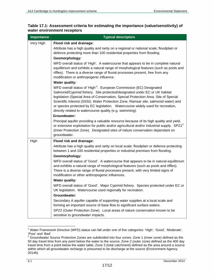
17.2.37 Table 17.1 shows the assessment criteria that have been applied in determining the sensitivity/importance of the receptor.
A14 Cambridge to Huntingdon improvement scheme Environmental Statement
6.1 December 2014
17/12
Table 17.1: Assessment criteria for estimating the importance (value/sensitivity) of water environment receptors
Importance Typical descriptors
Very High Flood risk and drainage:
Attribute has a high quality and rarity on a regional or national scale; floodplain or defence protecting more than 100 residential properties from flooding.
Geomorphology:
WFD overall status of ‘High’. A watercourse that appears to be in complete natural equilibrium and exhibits a natural range of morphological features (such as pools and riffles). There is a diverse range of fluvial processes present, free from any modification or anthropogenic influence.
Water quality:
WFD overall status of ‘High’1. European Commission (EC) Designated Salmonid/Cyprinid fishery. Site protected/designated under EC or UK habitat legislation (Special Area of Conservation, Special Protection Area, Site of Special Scientific Interest (SSSI), Water Protection Zone, Ramsar site, salmonid water) and or species protected by EC legislation. Watercourse widely used for recreation, directly related to watercourse quality (e.g. swimming).
Groundwater:
Principal aquifer providing a valuable resource because of its high quality and yield, or extensive exploitation for public and/or agricultural and/or industrial supply. SPZ12 (Inner Protection Zone). Designated sites of nature conservation dependant on groundwater.
High Flood risk and drainage:
Attribute has a high quality and rarity on local scale; floodplain or defence protecting between 1 and 100 residential properties or industrial premises from flooding.
Geomorphology:
WFD overall status of ‘Good’. A watercourse that appears to be in natural equilibrium and exhibits a natural range of morphological features (such as pools and riffles). There is a diverse range of fluvial processes present, with very limited signs of modification or other anthropogenic influences.
Water quality:
WFD overall status of ‘Good’. Major Cyprinid fishery. Species protected under EC or UK legislation. Watercourse used regionally for recreation.
Groundwater:
Secondary A aquifer capable of supporting water supplies at a local scale and forming an important source of base flow to significant surface waters.
SPZ2 (Outer Protection Zone). Local areas of nature conservation known to be sensitive to groundwater impacts.
1 Water Framework Directive (WFD) status can fall under one of five categories: ‘High’, ‘Good’, ‘Moderate’, ‘Poor’ and ‘Bad’ 2 Groundwater Source Protection Zones are subdivided into four zones: Zone 1 (inner zone) defined as the 50 day travel time from any point below the water to the source; Zone 2 (outer zone) defined as the 400 day travel time from a point below the water table; Zone 3 (total catchment) defined as the area around a source within which all groundwater recharge is presumed to be discharge at the source (Environment Agency 2014b).
A14 Cambridge to Huntingdon improvement scheme Environmental Statement
6.1 December 2014
17/13
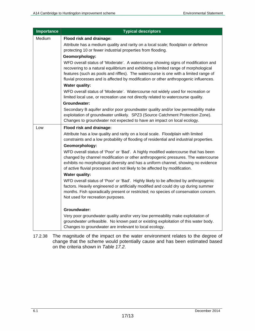
Importance Typical descriptors
Medium Flood risk and drainage:
Attribute has a medium quality and rarity on a local scale; floodplain or defence protecting 10 or fewer industrial properties from flooding.
Geomorphology:
WFD overall status of ‘Moderate’. A watercourse showing signs of modification and recovering to a natural equilibrium and exhibiting a limited range of morphological features (such as pools and riffles). The watercourse is one with a limited range of fluvial processes and is affected by modification or other anthropogenic influences.
Water quality:
WFD overall status of ‘Moderate’. Watercourse not widely used for recreation or limited local use, or recreation use not directly related to watercourse quality.
Groundwater:
Secondary B aquifer and/or poor groundwater quality and/or low permeability make exploitation of groundwater unlikely. SPZ3 (Source Catchment Protection Zone). Changes to groundwater not expected to have an impact on local ecology.
Low Flood risk and drainage:
Attribute has a low quality and rarity on a local scale. Floodplain with limited constraints and a low probability of flooding of residential and industrial properties.
Geomorphology:
WFD overall status of ‘Poor’ or ‘Bad’. A highly modified watercourse that has been changed by channel modification or other anthropogenic pressures. The watercourse exhibits no morphological diversity and has a uniform channel, showing no evidence of active fluvial processes and not likely to be affected by modification.
Water quality:
WFD overall status of ‘Poor’ or ‘Bad’. Highly likely to be affected by anthropogenic factors. Heavily engineered or artificially modified and could dry up during summer months. Fish sporadically present or restricted; no species of conservation concern. Not used for recreation purposes.
Groundwater:
Very poor groundwater quality and/or very low permeability make exploitation of groundwater unfeasible. No known past or existing exploitation of this water body. Changes to groundwater are irrelevant to local ecology.
17.2.38 The magnitude of the impact on the water environment relates to the degree of change that the scheme would potentially cause and has been estimated based on the criteria shown in Table 17.2.
A14 Cambridge to Huntingdon improvement scheme Environmental Statement
6.1 December 2014
17/14
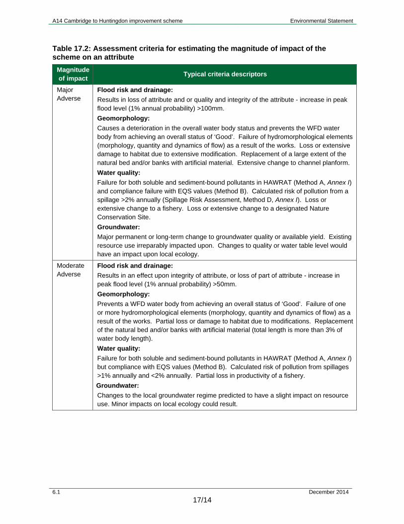
Table 17.2: Assessment criteria for estimating the magnitude of impact of the scheme on an attribute
Magnitude of impact
Typical criteria descriptors
Major Adverse
Flood risk and drainage:
Results in loss of attribute and or quality and integrity of the attribute - increase in peak flood level (1% annual probability) >100mm.
Geomorphology:
Causes a deterioration in the overall water body status and prevents the WFD water body from achieving an overall status of ‘Good’. Failure of hydromorphological elements (morphology, quantity and dynamics of flow) as a result of the works. Loss or extensive damage to habitat due to extensive modification. Replacement of a large extent of the natural bed and/or banks with artificial material. Extensive change to channel planform.
Water quality:
Failure for both soluble and sediment-bound pollutants in HAWRAT (Method A, Annex I) and compliance failure with EQS values (Method B). Calculated risk of pollution from a spillage >2% annually (Spillage Risk Assessment, Method D, Annex I). Loss or extensive change to a fishery. Loss or extensive change to a designated Nature Conservation Site.
Groundwater:
Major permanent or long-term change to groundwater quality or available yield. Existing resource use irreparably impacted upon. Changes to quality or water table level would have an impact upon local ecology.
Moderate Adverse
Flood risk and drainage:
Results in an effect upon integrity of attribute, or loss of part of attribute - increase in peak flood level (1% annual probability) >50mm.
Geomorphology:
Prevents a WFD water body from achieving an overall status of ‘Good’. Failure of one or more hydromorphological elements (morphology, quantity and dynamics of flow) as a result of the works. Partial loss or damage to habitat due to modifications. Replacement of the natural bed and/or banks with artificial material (total length is more than 3% of water body length).
Water quality:
Failure for both soluble and sediment-bound pollutants in HAWRAT (Method A, Annex I) but compliance with EQS values (Method B). Calculated risk of pollution from spillages >1% annually and <2% annually. Partial loss in productivity of a fishery.
Groundwater:
Changes to the local groundwater regime predicted to have a slight impact on resource use. Minor impacts on local ecology could result.

A14 Cambridge to Huntingdon improvement scheme Environmental Statement
6.1 December 2014
17/15
Magnitude of impact
Typical criteria descriptors
Minor Adverse
Flood risk and drainage:
Results in some measurable change in attributes quality or vulnerability - increase in peak flood level (1% annual probability) >10mm.
Geomorphology:
Potential for failure in one of the hydromorphological elements (morphology, quantity and dynamics of flow) as a result of the works. Slight change/deviation from baseline conditions or partial loss or damage to habitat due to modifications.
Water quality:
Failure for either soluble or sediment-bound pollutants in HAWRAT. Calculated risk of pollution from spillages >0.5% annually and <1% annually.
Groundwater:
Changes to groundwater quality, levels or yields not representing a risk to existing resource use or ecology.
Negligible Flood risk and drainage:
Results in an effect on attribute, but of insufficient magnitude to affect the use or integrity - Negligible change in peak flood level (1% annual probability) <+/- 10mm.
Geomorphology:
No alteration to hydromorphological elements. Very slight change from surface water baseline conditions, approximating to a ‘no change’ situation.
Water quality:
No risk identified by HAWRAT (Pass both soluble and sediment-bound pollutants). Risk of pollution from spillages <0.5%.
Groundwater:
Very slight change from groundwater baseline conditions approximating to a ‘no change’ situation.
Minor Beneficial
Flood risk and drainage:
Results in some beneficial effect on attribute or a reduced risk of negative effect occurring - reduction in peak flood level (1% annual probability) >10mm.
Geomorphology:
Potential for improvements in one of the hydromorphological elements (morphology, quantity and dynamics of flow) as a result of the works. Slight change/deviation from baseline conditions or partial improvement or gain in riparian or in-channel habitat.
Water quality:
HAWRAT assessment of either soluble or sediment-bound pollutants becomes ‘Pass’ from an existing site where the baseline was a ‘Fail’ condition. Calculated reduction in existing spillage risk by 50% or more (when existing spillage risk is <1% annually).
Groundwater:
Changes to groundwater quality, levels or yields representing a minor improvement to existing resource use or ecology.
A14 Cambridge to Huntingdon improvement scheme Environmental Statement
6.1 December 2014
17/16
Magnitude of impact
Typical criteria descriptors
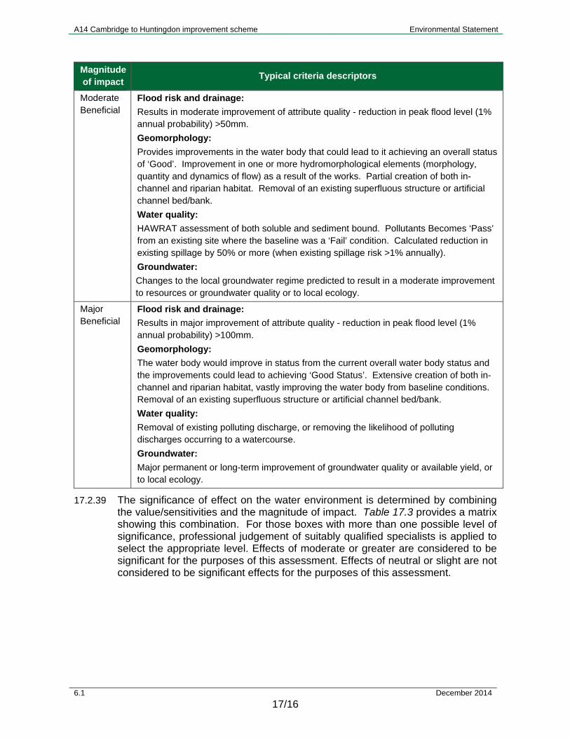
Moderate Beneficial
Flood risk and drainage:
Results in moderate improvement of attribute quality - reduction in peak flood level (1% annual probability) >50mm.
Geomorphology:
Provides improvements in the water body that could lead to it achieving an overall status of ‘Good’. Improvement in one or more hydromorphological elements (morphology, quantity and dynamics of flow) as a result of the works. Partial creation of both in-channel and riparian habitat. Removal of an existing superfluous structure or artificial channel bed/bank.
Water quality:
HAWRAT assessment of both soluble and sediment bound. Pollutants Becomes ‘Pass’ from an existing site where the baseline was a ‘Fail’ condition. Calculated reduction in existing spillage by 50% or more (when existing spillage risk >1% annually).
Groundwater:
Changes to the local groundwater regime predicted to result in a moderate improvement to resources or groundwater quality or to local ecology.
Major Beneficial
Flood risk and drainage:
Results in major improvement of attribute quality - reduction in peak flood level (1% annual probability) >100mm.
Geomorphology:
The water body would improve in status from the current overall water body status and the improvements could lead to achieving ‘Good Status’. Extensive creation of both in-channel and riparian habitat, vastly improving the water body from baseline conditions. Removal of an existing superfluous structure or artificial channel bed/bank.
Water quality:
Removal of existing polluting discharge, or removing the likelihood of polluting discharges occurring to a watercourse.
Groundwater:
Major permanent or long-term improvement of groundwater quality or available yield, or to local ecology.
17.2.39 The significance of effect on the water environment is determined by combining the value/sensitivities and the magnitude of impact. Table 17.3 provides a matrix showing this combination. For those boxes with more than one possible level of significance, professional judgement of suitably qualified specialists is applied to select the appropriate level. Effects of moderate or greater are considered to be significant for the purposes of this assessment. Effects of neutral or slight are not considered to be significant effects for the purposes of this assessment.

A14 Cambridge to Huntingdon improvement scheme Environmental Statement
6.1 December 2014
17/17
Table 17.3: Assessment criteria for determining significance of effect categories
Importance of attribute
Magnitude of impact
Negligible Minor Moderate Major
Very High Neutral Moderate or Large
Large or Very Large Very large
High Neutral Slight or Moderate
Moderate or Large Large or Very Large
Medium Neutral Slight Moderate Large
Low Neutral Neutral Slight Slight or Moderate
Limitations of the assessment
17.2.40 Hydraulic models are always an approximation of the natural processes in the watercourse that they simulate. Consequently, there are inherent uncertainties and assumptions. Despite this, they represent the most accurate practicable method of simulating the response of each watercourse to rainfall. The models used have been adopted by the Environment Agency for their development of flood zones.
17.2.41 Ground investigation data were obtained from previous studies in 2009 (Costain, 2009a and Costain 2009b) supported by additional groundwater monitoring data which only partially covers the study area.
17.2.42 Information on private water supplies has been based on records held by the Local Authorities. The potential for further, unrecorded, private abstractions cannot be ruled out.
17.2.43 Definition of the catchment areas for some of the water bodies has been difficult due to the low lying nature of the land and the historic human interventions in draining the Fens in the 17th century. This has produced a complex network of drains that do not necessarily tie in with the small variations in topography. As a result, standard approaches regularly used in road schemes do not provide topographical resolution at a fine enough resolution to delineate the catchments. To overcome this, light detection and ranging (LIDAR) data have been processed to produce a high resolution watershed map of the road corridor, with drainage paths inferred. These high resolution data still do not incorporate all the detail of the drainage network so final catchments have been derived by hand; this involve combining map, watershed analysis and site walkover information. The catchments have been used to define low flow estimates using areal scaling with Low Flows Enterprise software. Flow estimates have been achieved for a series of representative catchments, primarily assigned according to soils information.
17.2.44 Many of the watercourses identified as receptors are small, and consequently have very low Q95 (the flow which was equalled or exceeded for 95% of the flow record) estimates. In these instances the default value of 0.001m3/s as recommended by HD45/09 (Highways Agency, 2009) has been utilised.
A14 Cambridge to Huntingdon improvement scheme Environmental Statement
6.1 December 2014
17/18
17.3 Baseline conditions
Field surveys
17.3.1 Site visits were undertaken to gain an understanding of the hydrological environment in the vicinity of the scheme. Walkover assessments carried out in 2014 included:
a geomorphology walkover survey;
a survey to inform a WFD Compliance Assessment;
an aquatic ecology survey to inform a WFD Compliance Assessment (reported in Chapter 11);
a water quality walkover survey;
a groundwater walkover survey; and
a walkover survey to inform the hydraulic modelling and Flood Risk Assessment (FRA).
17.3.2 These surveys covered the entire study area. Visual inspections were made of the main watercourses, including the river Great Ouse, and some of the minor watercourses and drainage ditches in the study area. For water quality, groundwater and hydraulic modelling/FRA, it was necessary to visit the site to understand how the hydrological/hydraulic systems currently function on the ground.
Flood risk and drainage
17.3.3 The FRA (Appendix 17.1) provides a comprehensive summary of the existing flood risk along the full length of the scheme in accordance with the National Planning Policy Framework and accompanying National Planning Policy Guidance. The FRA covers the risk of flooding from all sources including:
main rivers;
ordinary watercourses (including award drains);
sewers;
surface water;
pluvial;
groundwater;
reservoirs;
canals; and
failure of flood defences.
17.3.4 Where available, hydraulic models provided by the Environment Agency have been used to estimate peak water levels for a range of return period events. These are detailed in the FRA (Appendix 17.1) together with the baseline conditions against which the potential impact of the scheme has been assessed. Where hydraulic models do not exist or do not provide adequate coverage, peak water levels have either been provided by the Environment Agency or an assessment has been made based on the extent of the published flood zone.
A14 Cambridge to Huntingdon improvement scheme Environmental Statement
6.1 December 2014
17/19
17.3.5 In accordance with current Defra guidance, and as agreed with the Environment Agency, the baseline flood event to assess the with-scheme flood risk against is the 1% (1 in 100 year) annual exceedance probability (AEP) event. Any mitigation measures have included an allowance for climate change of an additional 20% in rainfall intensity or peak river flow.
Description of surface and groundwater features
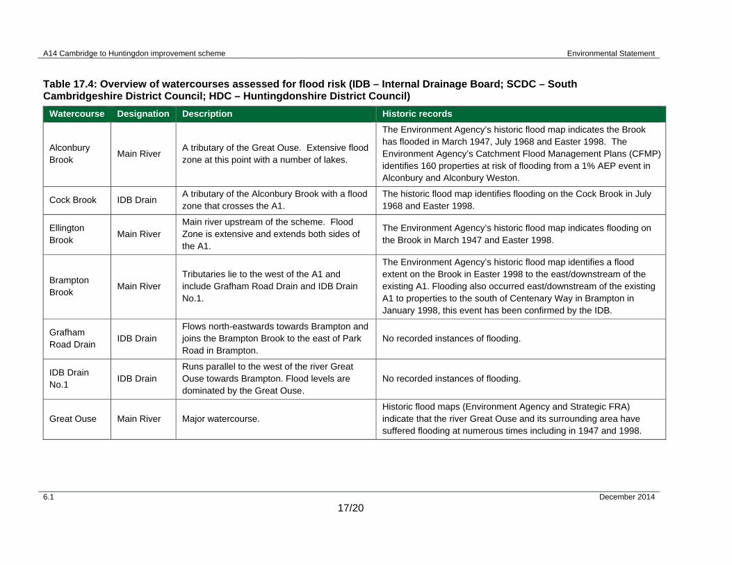
17.3.6 The scheme crosses a number of watercourses along its length. Table 17.4 provides an overview of each watercourse.
A14 Cambridge to Huntingdon improvement scheme Environmental Statement
6.1 December 2014
17/20
Table 17.4: Overview of watercourses assessed for flood risk (IDB – Internal Drainage Board; SCDC – South Cambridgeshire District Council; HDC – Huntingdonshire District Council)
Watercourse Designation Description Historic records
Alconbury Brook
Main River A tributary of the Great Ouse. Extensive flood zone at this point with a number of lakes.
The Environment Agency’s historic flood map indicates the Brook has flooded in March 1947, July 1968 and Easter 1998. The Environment Agency’s Catchment Flood Management Plans (CFMP) identifies 160 properties at risk of flooding from a 1% AEP event in Alconbury and Alconbury Weston.
Cock Brook IDB Drain A tributary of the Alconbury Brook with a flood zone that crosses the A1.
The historic flood map identifies flooding on the Cock Brook in July 1968 and Easter 1998.
Ellington Brook
Main River Main river upstream of the scheme. Flood Zone is extensive and extends both sides of the A1.
The Environment Agency’s historic flood map indicates flooding on the Brook in March 1947 and Easter 1998.
Brampton Brook
Main River Tributaries lie to the west of the A1 and include Grafham Road Drain and IDB Drain No.1.
The Environment Agency’s historic flood map identifies a flood extent on the Brook in Easter 1998 to the east/downstream of the existing A1. Flooding also occurred east/downstream of the existing A1 to properties to the south of Centenary Way in Brampton in January 1998, this event has been confirmed by the IDB.
Grafham Road Drain
IDB Drain Flows north-eastwards towards Brampton and joins the Brampton Brook to the east of Park Road in Brampton.
No recorded instances of flooding.
IDB Drain No.1
IDB Drain Runs parallel to the west of the river Great Ouse towards Brampton. Flood levels are dominated by the Great Ouse.
No recorded instances of flooding.
Great Ouse Main River Major watercourse. Historic flood maps (Environment Agency and Strategic FRA) indicate that the river Great Ouse and its surrounding area have suffered flooding at numerous times including in 1947 and 1998.

A14 Cambridge to Huntingdon improvement scheme Environmental Statement
6.1 December 2014
17/21
Watercourse Designation Description Historic records
West Brook
(Hall Green Brook)
Main River Majority of its tributaries are Award Drain, for which HDC have responsibility for maintenance.
Significant flooding problems within the village of Hilton, notably the October 2001 event which caused inundation of some properties. The 2009 scheme FRA stated that HDC do not currently undertake maintenance on the watercourse and anecdotal evidence suggests that flooding could occur through blockages of culverts. Additional discussions with the occupier of a property on Hilton Road, Fenstanton, suggests that there are flooding problems in the vicinity of ‘The Nursery’ (NGR: TL 3087 6760) resulting from the adjacent Award Drain being heavily silted and unable to discharge into the West Brook.
Oxholme Drain
Award Drain Tributary of the river Great Ouse. The drain is the responsibility of SCDC for maintenance.
No historic records of flooding within the scheme footprint. There have been reports (pers. comm. EA) of flooding further upstream within the village of Conington at the public house. This could be due to the array of different structures within the vicinity of the road junction, which in conjunction with poor maintenance, leads to blockages.
Covell’s Drain Award Drain
Rises as two branches. A tributary of the river Great Ouse. The drain is also the responsibility of SCDC. Flood zone merges with the flood zone for Oxholme Drain.
No historic records of flooding within the scheme vicinity; however, there are known flooding issues further downstream within the Parish of Fen Drayton.
Swavesey Drain
IDB Drain Tributary of the river Great Ouse. The responsibility of Swavesey IDB for maintenance and works consents.
There are no historic records of flooding on this watercourse.
Utton’s Drove Drain
Award Drain Tributary of the river Great Ouse. The responsibility of SCDC for maintenance and works consents.
There are no historic records of flooding on this watercourse.
Longstanton Brook
Award Drain Tributary of the Swavesey Drain. The responsibility of SCDC for maintenance and works consents.
No recorded instances of flooding.

A14 Cambridge to Huntingdon improvement scheme Environmental Statement
6.1 December 2014
17/22
Watercourse Designation Description Historic records
Oakington Brook
Award Drain Upstream of the A14. It is the responsibility of SCDC.
The Environment Agency’s historic flood map identifies flooding 1.8km north/downstream of the A14 in Oakington in May 1978 and October 2001. Main River Downstream of the A14 crossing.
Cottenham Lode/Beck Brook
Main River Downstream of the A14.
It is a tributary to the Oakington Brook. The Environment Agency’s historic flood map identifies flooding downstream of the A14 in Girton in May 1978 and October 2001. There has been flooding to property in the village of Girton downstream of the A14. Award Drain
Upstream of the A14 – the responsibility of SCDC.
Washpit Brook
Main River
Main River upstream of the A14. Downstream of the A14 is awarded to the SCDC and there is no area of Flood Zone 3.
Tributary of the Oakington Brook.
The Environment Agency’s historic flood map identifies flooding downstream of the A14 in Girton in May 1978 and October 2001.
Award Drains North of Cambridge
- Falls within the jurisdiction of both SCDC and Cambridge City Council for maintenance.
No recorded instances of flooding.
A14 Cambridge to Huntingdon improvement scheme Environmental Statement
6.1 December 2014
17/23
Surface water
WFD water bodies
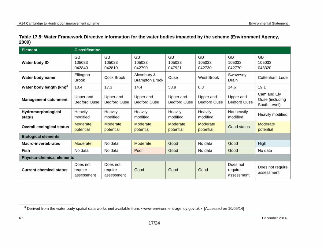
17.3.7 The proposed A14 Cambridge to Huntingdon improvement scheme is within the Anglian River Basin District as defined by the Environment Agency. The scheme lies within both the Upper Bedford Ouse catchment and the Cam and Ely Ouse catchment.
17.3.8 There are seven WFD water bodies potentially directly impacted by the scheme (Table 17.5, Environment Agency, 2009). The rivers lie within a predominately rural catchment, with some large urban areas located along the scheme footprint. Six of the water bodies are classified by the Environment Agency as Heavily Modified Water Bodies (HMWB) with only one water body not classified as a HMWB.
17.3.9 There is also one WFD groundwater body present within the scheme footprint near Bar Hill junction on the existing A14. The water body is the Cam and Ely Ouse Woburn Sands (GB40501G445700) and is classified as achieving Good Quantitative and Good Chemical Quality. Both nutrients and hazardous substances and other pollutants are detailed as pressures and risks to this groundwater body.
A14 Cambridge to Huntingdon improvement scheme Environmental Statement
6.1 December 2014
17/24
Table 17.5: Water Framework Directive information for the water bodies impacted by the scheme (Environment Agency, 2009)
Element Classification
Water body ID GB 105033 042840
GB 105033 042810
GB 105033 042790
GB 105033 047921
GB 105033 042730
GB 105033 042770
GB 105033 043320
Water body name Ellington Brook
Cock Brook Alconbury & Brampton Brook
Ouse West Brook Swavesey Drain
Cottenham Lode
Water body length (km)3 10.4 17.3 14.4 58.9 8.3 14.6 19.1
Management catchment Upper and Bedford Ouse
Upper and Bedford Ouse
Upper and Bedford Ouse
Upper and Bedford Ouse
Upper and Bedford Ouse
Upper and Bedford Ouse
Cam and Ely Ouse (including South Level)
Hydromorphological status
Heavily modified
Heavily modified
Heavily modified
Heavily modified
Heavily modified
Not heavily modified
Heavily modified
Overall ecological status Moderate potential
Moderate potential
Moderate potential
Moderate potential
Moderate potential
Good status Moderate potential
Biological elements
Macro-invertebrates Moderate No data Moderate Good No data Good High
Fish No data No data Poor Good No data Good No data
Physico-chemical elements
Current chemical status Does not require assessment
Does not require assessment
Good Good Good Does not require assessment
Does not require assessment
3 Derived from the water body spatial data worksheet available from: <www.environment-agency.gov.uk> [Accessed on 16/05/14]

A14 Cambridge to Huntingdon improvement scheme Environmental Statement
6.1 December 2014
17/25
Element Classification
Hydromorphological elements
Quantity and dynamics of flow
Supports good
Supports good
Supports good Supports good
Supports good
Supports good
Supports good
Morphology No data No data No data No data No data Supports good
No data
A14 Cambridge to Huntingdon improvement scheme Environmental Statement
6.1 December 2014
17/26
17.3.10 The baseline conditions of each of the WFD water bodies have been assessed against the three WFD quality elements: biological, physico-chemical and hydromorphological. The full baseline assessment can be found in Appendix 17.3.
Other watercourses
17.3.11 Much of the arable land within and adjacent to the study area is drained by a network of field drains, IDB drains, Award Drains and brooks. These are listed in Table 17.8.
Lakes and ponds
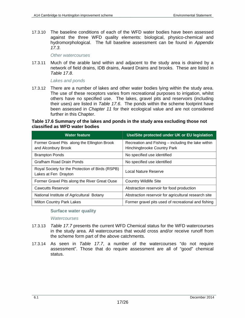
17.3.12 There are a number of lakes and other water bodies lying within the study area. The use of these receptors varies from recreational purposes to irrigation, whilst others have no specified use. The lakes, gravel pits and reservoirs (including their uses) are listed in Table 17.6. The ponds within the scheme footprint have been assessed in Chapter 11 for their ecological value and are not considered further in this Chapter.
Table 17.6 Summary of the lakes and ponds in the study area excluding those not classified as WFD water bodies
Water feature Use/Site protected under UK or EU legislation
Former Gravel Pits along the Ellington Brook and Alconbury Brook
Recreation and Fishing – including the lake within Hinchingbrooke Country Park
Brampton Ponds No specified use identified
Grafham Road Drain Ponds No specified use identified
Royal Society for the Protection of Birds (RSPB) Lakes at Fen Drayton
Local Nature Reserve
Former Gravel Pits along the River Great Ouse Country Wildlife Site
Cawcutts Reservoir Abstraction reservoir for food production
National Institute of Agricultural Botany Abstraction reservoir for agricultural research site
Milton Country Park Lakes Former gravel pits used of recreational and fishing
Surface water quality
Watercourses
17.3.13 Table 17.7 presents the current WFD Chemical status for the WFD watercourses in the study area. All watercourses that would cross and/or receive runoff from the scheme form part of the above catchments.
17.3.14 As seen in Table 17.7, a number of the watercourses “do not require assessment”. Those that do require assessment are all of “good” chemical status.

A14 Cambridge to Huntingdon improvement scheme Environmental Statement
6.1 December 2014
17/27
Table 17.7: Summary of the chemical status (water quality) for WFD watercourses in the proposed study area (Figure 17.4)
Water feature WFD ID GB1050330-
WFD chemical status
WFD chemical status objective by 2015
Receiving direct road runoff from current A14/A1 Y/N/P*
Alconbury Brook 42820 DNRA* N/A P via A1
Cock Brook 42810 DNRA* N/A P via A1
Ellington Brook 42840 DNRA* N/A P via A1 &/or A14
Alconbury & Brampton Brook 42790 Good N/A P via A1&/or A14
River Great Ouse 47921 Good High P via A14 within Huntington
West Brook 42730 Good High P via A14
Fen Drayton 42740 DNRA* N/A N
Swavesey Drain 1-3 (includes Uttons Drive)
42770 DNRA* N/A P via A14
Cottenham Lode (Beck Brook)
43320 DNRA* N/A P via A14
River Cam 42750 Good High P via A14
*DNRA – “Do not require assessment”; Y = Yes, N = No, P = Potentially
17.3.15 There are a number of other non-WFD watercourses in the study area; these are made up of IDB drains, Award Drains and other drains. Baseline water quality monitoring was previously carried out on a number of these watercourses in 2007 to determine the River Ecosystem (RE)4 classification rating and to provide values for levels of copper and zinc (Environment Agency, 2014b). The majority of the watercourses were found to be on average a RE3 (fairly good quality) or better. This information was also used to inform water hardness parameters used in the HD45/09 water quality assessment. Table 17.8 summarises the remaining watercourses in the study area and the WFD water body that these watercourses drain into.
4 River Ecosystem (RE) classification system consists of five classes (1-5) and is based on the same determinands used in chemistry assessments of BOD, ammonia and dissolved oxygen but also includes the additional determinands of (free (or un-ionised) ammonia, pH, hardness, dissolved copper and total zinc) that reflect the requirements of a river ecosystem.

A14 Cambridge to Huntingdon improvement scheme Environmental Statement
6.1 December 2014
17/28
Table 17.8 Summary of the watercourses in the proposed study area not including those classified as WFD water bodies
Water feature Receiving WFD
water body Receiving direct road runoff from
current A14/A1 (Y/N/P) *
Rectory Farm Drain Ellington Brook P via A1
Brampton Brook(outside WFD designation)
Ouse P via A1
Grafham Road Drain Ouse P via A1
Buckden Road Drain Ouse P via A1
IBD Drain Ouse N
Ouse East Drain (drain into the river Great Ouse)
Ouse N
Offord Road Drain Ouse N
Debden Drain Ouse N
Huntingdon DC Award Drain West Brook P via A14 where it crosses further north
Ellington Brook Drain Ellington Brook P via A1
Alconbury Brook Drain Alconbury Brook P via A1
Cock Brook Drain Cock Brook P via A1
Hinton Road Drain West Brook N
Conington Road Drain West Brook N
Oxholme Drain Ouse P via A14 where it crosses further north
Cowells Drain Fen Drayton P via A14 where it crosses further north
Drain to Fen Drayton Fen Drayton P via A14
Longstanton Brook & connecting drains Cottenham Lode P via A14
Oakington Brook & connecting drains Cottenham Lode P via A14
Dry Drayton Junction Drain Cottenham Lode P via A14
Washpit Brook & connecting drains Cottenham Lode P via A14
Public Drain Cottenham Lode P via A14
Thirteenth Public Drain River Cam P via A14
*Y = Yes, N = No, P = Potentially
Lakes and other waterbodies
17.3.16 Lakes and other water bodies in the study area are described in Table 17.6. It has been determined that the lakes would not receive any discharge from the scheme.
A14 Cambridge to Huntingdon improvement scheme Environmental Statement
6.1 December 2014
17/29
Surface water licensed abstractions and consented discharges
17.3.17 There are three surface water abstractions for agricultural and recreational use (but no known potable abstractions). There are also a number of consented discharges to surface waters, many of which are now revoked. There are ten known active discharge licences in the area.
Groundwater
17.3.18 The Environment Agency operates a classification system to categorise the importance of groundwater resources (aquifers) and their sensitivity to contamination. Aquifers are classified as Principal, Secondary A, Secondary B, Secondary (undifferentiated) and unproductive strata based on the amenity of the resource.
17.3.19 Based on the Environment Agency website, the aquifer classification for each of the underlying strata is shown in Table 17.9. The geographical distributions of the Secondary A and Principal aquifers are shown in Figure 17.3.
Table 17.9 Aquifer classifications
Stratum Aquifer classification
Alluvium Secondary A
River Terrace Deposits Secondary A
Glacial Head Deposits Secondary A
Glacial Till Non Productive
Gault Clay Non Productive
Woburn Sands Principal Aquifer
Kimmeridge Clay Non Productive
Ampthill Clay Non Productive
Oxford Clay Non Productive
Groundwater Levels and Flow Direction
17.3.20 Groundwater level information has been obtained from the 2009 and 2011 (Daykin, 2011) monitoring phases, comprising 116 observation boreholes across the project area. The data were limited to two rounds of readings. In addition, logging data was recorded at some selected locations; albeit some of the logged levels seem to have had calibration depth issues. A more extensive groundwater level monitoring dataset is available for locations in the vicinity of borrow pit 1 (comprising manual dip measurements at six boreholes at approximately monthly intervals between 2002 and 2014) and borrow pit 3 (monthly groundwater level dipping from October 2008 to May 2014).
17.3.21 Overall, the available dataset confirms the presence of shallow groundwater beneath the scheme within drift deposits. Groundwater levels have been found to range from 0.2m below ground level (mBGL) to 4.8mBGL, with the average level being 1.6m.
17.3.22 The long-term dataset from around the borrow pit 1 area showed an overall range of variation in groundwater levels of up to 2m, with short term, season-to-season variation of up to 1.8m at some boreholes.

A14 Cambridge to Huntingdon improvement scheme Environmental Statement
6.1 December 2014
17/30
17.3.23 The long-term dataset from around borrow pit 3 confirms shallow groundwater conditions of 2m deep on average, but also indicates variable seasonal fluctuations (0.6 to 3.4m) and variable minimum groundwater depths (0.2 to 2m) from location to location.
17.3.24 The general shallow groundwater flow direction is expected to be in line with the topography and therefore extends generally south to north, with local variation around areas of higher ground and the river Great Ouse.
17.3.25 There is only one groundwater level monitoring location for the Woburn Sands, and on that basis, groundwater flow direction cannot be determined.
Groundwater abstractions and resources
17.3.26 Based on the Environment Agency’s website, the route does not lie within any groundwater SPZ. The nearest SPZ is associated with an abstraction point at Hemingford Grey to the north of Godmanchester and east of Huntingdon. However, the route falls outside the total catchment area.
17.3.27 Based on the Catchment Abstraction Management Strategies reports5 (Environment Agency, 2013b; Environment Agency, 2013c), the Woburn Sands aquifer is heavily exploited within the Upper Ouse and Bedford Ouse catchment and is classified as a groundwater body not available for licensing. As part of the Cam and Ely Ouse catchment, no productive strata are identified, including sand and gravel aquifers.
17.3.28 Based on consultations with local authorities, the private water supplies recorded in Table 17.10 are expected to be located within the hydrogeological study area. The potential for further, unrecorded, private water supplies cannot be ruled out at this stage. The identified private water supplies are shown on Figure 17.5.
Table 17.10 Private water supplies within the hydrogeological study area
PWS ID Distance from scheme Direction from nearest feature
PWS-5 575m Northeast of borrow pit 3
PWS-6 375m East of borrow pit 3
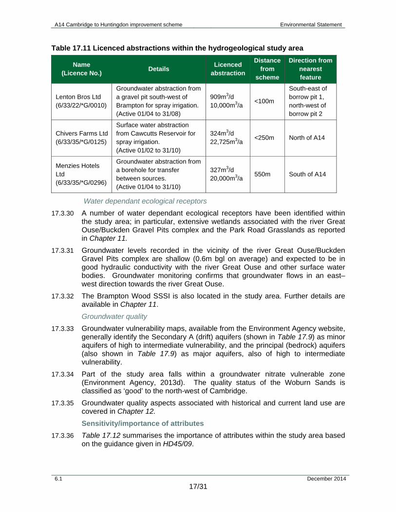
17.3.29 Based on consultation with the Environment Agency, the licenced abstractions listed in Table 17.11 are expected to be located within the zone of influence of the scheme. These are shown on Figure 17.5.
5 Relevant Catchment Abstraction Management Strategies (CAMS) areas include:
- Cam and Ely Ouse - Upper Ouse and Bedford Ouse
A14 Cambridge to Huntingdon improvement scheme Environmental Statement
6.1 December 2014
17/31
Table 17.11 Licenced abstractions within the hydrogeological study area
Name (Licence No.)
Details Licenced
abstraction
Distance from
scheme
Direction from nearest feature
Lenton Bros Ltd (6/33/22/*G/0010)
Groundwater abstraction from a gravel pit south-west of Brampton for spray irrigation. (Active 01/04 to 31/08)
909m3/d 10,000m3/a
<100m
South-east of borrow pit 1, north-west of borrow pit 2
Chivers Farms Ltd (6/33/35/*G/0125)
Surface water abstraction from Cawcutts Reservoir for spray irrigation. (Active 01/02 to 31/10)
324m3/d 22,725m3/a
<250m North of A14
Menzies Hotels Ltd (6/33/35/*G/0296)
Groundwater abstraction from a borehole for transfer between sources. (Active 01/04 to 31/10)
327m3/d 20,000m3/a
550m South of A14
Water dependant ecological receptors
17.3.30 A number of water dependant ecological receptors have been identified within the study area; in particular, extensive wetlands associated with the river Great Ouse/Buckden Gravel Pits complex and the Park Road Grasslands as reported in Chapter 11.
17.3.31 Groundwater levels recorded in the vicinity of the river Great Ouse/Buckden Gravel Pits complex are shallow (0.6m bgl on average) and expected to be in good hydraulic conductivity with the river Great Ouse and other surface water bodies. Groundwater monitoring confirms that groundwater flows in an east–west direction towards the river Great Ouse.
17.3.32 The Brampton Wood SSSI is also located in the study area. Further details are available in Chapter 11.
Groundwater quality
17.3.33 Groundwater vulnerability maps, available from the Environment Agency website, generally identify the Secondary A (drift) aquifers (shown in Table 17.9) as minor aquifers of high to intermediate vulnerability, and the principal (bedrock) aquifers (also shown in Table 17.9) as major aquifers, also of high to intermediate vulnerability.
17.3.34 Part of the study area falls within a groundwater nitrate vulnerable zone (Environment Agency, 2013d). The quality status of the Woburn Sands is classified as ‘good’ to the north-west of Cambridge.
17.3.35 Groundwater quality aspects associated with historical and current land use are covered in Chapter 12.
Sensitivity/importance of attributes
17.3.36 Table 17.12 summarises the importance of attributes within the study area based on the guidance given in HD45/09.

A14 Cambridge to Huntingdon improvement scheme Environmental Statement
6.1 December 2014
17/32
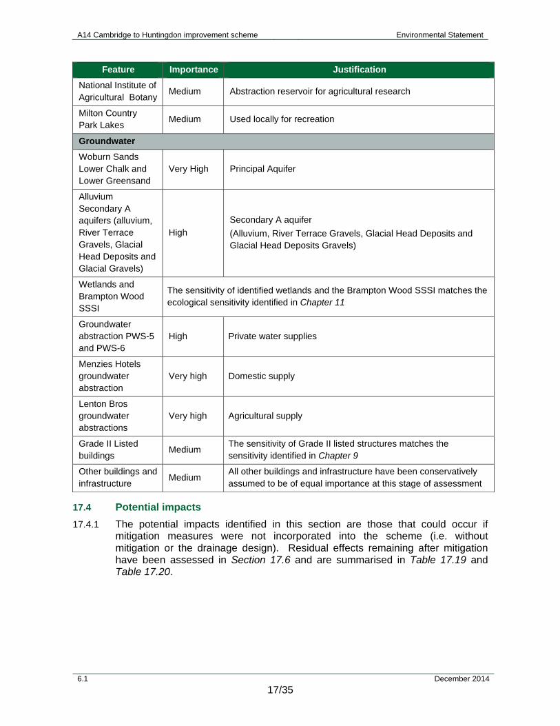
17.3.37 The value of the groundwater environment can be defined in terms of its usage and receptors. Based on definitions provided in Table 17.1, the Woburn Sands aquifer is considered to be of very high sensitivity, whilst the Secondary A aquifers (Alluvium, River Terrace Deposits, Glacial Head Deposits) are considered to be of high sensitivity.
17.3.38 The sensitivity of identified ecological sites is consistent with the sensitivities defined in Chapter 11
Table 17.12 Summary of the importance of attributes within the study area for flooding, surface waters and groundwater (Table 17.1 for sensitivity descriptions)
Feature Importance Justification
Flood risk
Alconbury Brook Low The scheme does not impact upon the watercourse in the vicinity of existing property
Cock Brook Low A number of properties are located upstream of the existing A1 watercourse crossing within Flood Zone 3, but would not be impacted by the scheme
Ellington Brook Low No properties upstream of the scheme
Brampton Brook (upstream A1)
Low There are very few properties upstream of the scheme on the Brampton Brook.
Brampton Brook (downstream A1)
Very High The town of Brampton is located downstream of the scheme with a large number of properties within Flood Zone 3
Grafham Road Drain
Low Few properties within the scheme’s zone of influence on the watercourse
IDB Drain No. 1 Low Few properties within the scheme’s zone of influence on the watercourse
River Great Ouse Very High There are properties upstream and downstream of the scheme within Flood Zone 3 at Offord Cluny and Godmanchester
West Brook (Hall Green Brook)
Medium Properties located within flood zone upstream at Conington and downstream at Fenstanton
Oxholme Drain Low The watercourse is in a rural area with few properties
Covell's Drain Medium Properties within Flood Zone 3 upstream of the scheme crossing
Utton's Drove Drain Low Water treatment works located close to the scheme crossing
Longstanton Brook High Properties located immediately upstream of the scheme
Oakington Brook Very High Numerous properties within Flood Zone 3 upstream of the scheme
Cottenham Lode (Beck Brook)
Low Few properties within the scheme’s zone of influence on the watercourse
Washpit Brook Low Few properties within the scheme’s zone of influence on the watercourse

A14 Cambridge to Huntingdon improvement scheme Environmental Statement
6.1 December 2014
17/33
Feature Importance Justification
Surface water
WFD water bodies
Alconbury Brook High
WFD water body – moderate potential
Expected to support minor coarse fish species and eel. Survey results have confirmed the presence of otter6 and water vole7 in the watercourse
Ellington Brook High
WFD water body – moderate potential
Expected to support minor coarse fish species and eel. Survey results have confirmed presence of otter in the watercourse
Swavesey Drain High WFD water body – good status
Expected to support minor coarse fish species and eel
Alconbury/ Brampton Brook
Medium WFD water body – moderate potential
Expected to support minor coarse fish species and eel
Cock Brook
Cottenham Lode (Beck Brook)
Fen Drayton
River Cam
River Ouse
West Brook
Other watercourses
Ellington Brook Drain
Medium Not a WFD water body but drains to a WFD watercourse of medium to high importance (Ellington Brook, Alconbury Brook and Cock Brook)
Alconbury Brook Drain
Cock Brook Drain
IBD Drain
Medium Not a WFD water body but drains to a WFD watercourse of medium importance (river Great Ouse)
Brampton Brook (outside WFD designation)
Grafham Road Drain
Buckden Road Drain
Ouse East Drain
Offord Road Drain
Debden Drain
6 Fully protected by International Directive and UK law: Conservation of Habitats and Species Regulations 2010 (as amended). 7 Protected by UK law: Wildlife and Countryside Act 1981 (as amended).

A14 Cambridge to Huntingdon improvement scheme Environmental Statement
6.1 December 2014
17/34
Feature Importance Justification
Huntingdon DC Award Drain
Medium Not WFD water bodies but they do drain to a WFD watercourse of medium importance (West Brook)
Hinton Road Drain
Connington Road Drain
Oxholme Drain Medium Not a WFD water body but drains to a WFD watercourse of medium importance (river Great Ouse)
Covells Drain Medium Not a WFD water body but drains to a WFD watercourse of medium importance (Fen Drayton)
Drain Fen Drayton Medium Not a WFD water body but drains to a WFD watercourse of medium importance (Fen Drayton)
Longstanton Brook & connecting drains
Medium Not WFD water bodies but they do drain to a WFD watercourse of medium importance (Cottenham Lode)
Oakington Brook and connecting drains
Dry Drayton Junction Drain
Public Drain
Washpit Brook & connecting drains
Public Drain Low - Medium
Not a WFD water body but drains to a WFD watercourse of medium importance (River Cam)
Drain with limited ecological value Thirteenth Public Drain
Lakes and other waterbodies
Former Gravel Pits along the Ellington Brook and Alconbury Brook
Medium Used locally for recreation
Brampton Ponds Low No specified use
Grafham Road Drain Ponds
Low No specified use
RSPB Lakes at Fen Drayton
Medium Local Nature Reserve
Buckden Gravel Pits along the river Great Ouse
Medium Local Nature Reserve
Cawcutts Reservoir Medium
Abstraction reservoir for food production
(Referred to by the Environment Agency as the Chivers Farm abstraction)
A14 Cambridge to Huntingdon improvement scheme Environmental Statement
6.1 December 2014
17/35
Feature Importance Justification
National Institute of Agricultural Botany
Medium Abstraction reservoir for agricultural research
Milton Country Park Lakes
Medium Used locally for recreation
Groundwater
Woburn Sands Lower Chalk and Lower Greensand
Very High Principal Aquifer
Alluvium Secondary A aquifers (alluvium, River Terrace Gravels, Glacial Head Deposits and Glacial Gravels)
High
Secondary A aquifer
(Alluvium, River Terrace Gravels, Glacial Head Deposits and Glacial Head Deposits Gravels)
Wetlands and Brampton Wood SSSI
The sensitivity of identified wetlands and the Brampton Wood SSSI matches the ecological sensitivity identified in Chapter 11
Groundwater abstraction PWS-5 and PWS-6
High Private water supplies
Menzies Hotels groundwater abstraction
Very high Domestic supply
Lenton Bros groundwater abstractions
Very high Agricultural supply
Grade II Listed buildings
Medium The sensitivity of Grade II listed structures matches the sensitivity identified in Chapter 9
Other buildings and infrastructure
Medium All other buildings and infrastructure have been conservatively assumed to be of equal importance at this stage of assessment
17.4 Potential impacts
17.4.1 The potential impacts identified in this section are those that could occur if mitigation measures were not incorporated into the scheme (i.e. without mitigation or the drainage design). Residual effects remaining after mitigation have been assessed in Section 17.6 and are summarised in Table 17.19 and Table 17.20.

A14 Cambridge to Huntingdon improvement scheme Environmental Statement
6.1 December 2014
17/36
Flood risk
Construction
17.4.2 During construction there would be a need to temporarily store soil and earthwork material within Flood Zone 3 (1% AEP on Ellington Brook, West Brook and Covell’s Drain). This would reduce floodplain storage should temporary storage coincide with a flood event.
17.4.3 Realignment of existing watercourses could also have a deleterious effect on flooding.
Operation
17.4.4 Impacts of the scheme on flood risk without mitigation are described in detail in the FRA (Appendix 17.1).
17.4.5 Without mitigation the scheme would create increased areas of impermeable surfaces, potentially leading to increased flooding along the receiving watercourses due to increased discharge volumes and rates.
17.4.6 Construction of new structures in floodplains would potentially reduce the capacity available for storage of floodwaters, thereby increasing the extent of flooding.
17.4.7 The FRA (Appendix 17.1) concludes that without mitigation the scheme would pose an unacceptable level of increase to existing levels of flood risk.
Other sources of flood risk
17.4.8 The FRA (Appendix 17.1) includes an assessment of other potential flood risks to and from the scheme including groundwater, surface water, sewer flooding and dam failure. The FRA concludes that none of these risks are significant to the scheme and that the scheme does not exacerbate them (and therefore mitigation would not be required).
Surface water - hydromorphology
Construction
17.4.9 In the absence of mitigation, effects of construction on the surface water environment could be complex and could include all WFD water bodies, watercourses and other water features within the construction footprint. These include:
Exposed bare earth surfaces, leading to higher silt loadings; and
Installation of culverts, outfalls, bridges (including piers) and any channel realignments would potentially require in-channel working. This could disturb existing channel bed forms (such as pools, riffles, depositional features).
Operation
17.4.10 As part of the scheme, a number of watercourses would be crossed either by new culverts, clear span bridges or by extending existing culverts. Outfall structures would also be required for a number of watercourses to enable drainage from the scheme to enter the drainage network. A number of watercourses would be permanently realigned (listed in Chapter 3) including two WFD water bodies.

A14 Cambridge to Huntingdon improvement scheme Environmental Statement
6.1 December 2014
17/37
17.4.11 As part of the scheme, one of the Buckden Gravel Pits would be in-filled due to an embankment supporting the river Great Ouse viaduct design. This is the furthest west gravel pit from the river Great Ouse and is unlikely to alter any existing lateral (river and its floodplain) connectivity with the river. The effect of the removal of the area of habitat within the lake (which is man-made) is detailed in Chapter 11.
Generic effects
Culverts
17.4.12 A permanent road crossing in the form of a culvert would be likely to remove the natural channel bed and banks and alter lateral connectivity of a channel with its floodplain. Culverts are also known to impact on flow dynamics and sediment transport processes.
Clear span bridges
17.4.13 Clear span bridges would not interfere with in-channel processes but could still have an effect on the riparian zone by inhibiting lateral connectivity.
Outfalls
17.4.14 The use of permanent outfall structures within a watercourse would have the potential to locally change the channel cross-section and alter flow dynamics and sediment processes. Each headwall would potentially replace a small section of natural channel bank and bed and encourage downstream erosion. However, the energies of the rivers in the study area are very low and it is not anticipated that they would cause notable erosion.
Channel realignment
17.4.15 Realignment of a watercourse would have potential to either reduce or increase the length of a channel, directly altering the gradient and changing flow dynamics and sediment processes. For example, if the length of a channel was to be increased then the gradient would correspondingly decrease, potentially leading to slower flows and localised deposition of fine sediment.
17.4.16 Channel realignment could also provide an opportunity for a historically modified channel to be re-naturalised.
Other effects
17.4.17 The scheme would also potentially increase the area of impervious surfaces, particularly along the new offline section of the scheme, leading to increased runoff with potential for downstream erosion. However, energies of the rivers in the study area are very low and would not be conducive to erosion.
Water Framework Directive water bodies
17.4.18 An assessment of WFD water bodies has been undertaken (Appendix 17.3). Table 17.13 provides details of the works potentially affecting the seven surface water bodies assessed as part of the WFD assessment (Appendix 17.3).

A14 Cambridge to Huntingdon improvement scheme Environmental Statement
6.1 December 2014
17/38
Table 17.13: Proposed works affecting the seven Water Framework Directive surface water bodies assessed as part of the scheme
Water body Water body ID Type of works Number of structures on
each water body
Alconbury and Brampton Brooks
GB105033042790 Culvert (extension) 1
Culvert (headwall) 1
Outfall 2
Clear span bridge 2
Realignment 1
Cock Brook GB105033042810 Outfall 1
Ellington Brook GB105033042840 Clear span bridge 1
Clear span footbridge 1
Great Ouse GB105033047921 Viaduct 1
West Brook GB105033042730 Realignment 1
Clear span bridge 1
Culvert headwall 2
Swavesey Drain GB105033042770 Culvert (extension) 3
Culvert (new) 1
Outfall 3
Cottenham Lode GB105033043320 Culvert (new) 2
Culvert (extension) 1
Culvert (headwall) 2
Outfall 4
17.4.19 There is also one WFD groundwater body present near Bar Hill junction on the existing A14. The groundwater body has been scoped out of the WFD compliance assessment since no impact would be likely to occur.
17.4.20 Appendix 17.3 provides the full WFD assessment and the following is a summary of key potential effects from the scheme on each of the WFD elements, based on a five stage assessment process.
Biological elements
Discussed in detail in Chapter 11.
Potential impacts on the biological elements could include habitat fragmentation, habitat loss and alterations to surface water discharge.
It is anticipated that any scheme impacts would be highly localised.
Physico-chemical elements
Discussed in detail in surface water quality below.

A14 Cambridge to Huntingdon improvement scheme Environmental Statement
6.1 December 2014
17/39
Hydromorphological elements
Discussed in detail in surface water – hydromorphology above.
Potential hydromorphological quality effects could arise from new in-channel structures including culverts and outfalls. These could include direct alterations to channel shape and form, changes to sediment and flow dynamics and disruption to lateral and longitudinal connectivity.
Clear span bridges and the river Great Ouse viaduct would be unlikely to have significant effects on the hydromorphological quality of water bodies. However, there could be very localised effects on floodplain connectivity due to bridge abutments.
Channel realignments at West Brook and Alconbury and Brampton Brook would have little impact on the hydromorphological quality of the water bodies.
Surface water quality
17.4.21 Surface water quality has been assessed using the HAWRAT tool and is summarised below with a full assessment provided in Appendix 17.2.
Construction
17.4.22 Without mitigation, potential impacts on surface water quality without mitigation could arise from the following activities:
general site clearance, stripping of vegetation and topsoil from the works area;
construction traffic movements including across temporary haul roads;
river engineering construction works including watercourse diversions, culverts, crossings and outfalls;
stockpiling of soil;
dewatering of borrow pits; and
sewage and surface water arising from site compounds.
17.4.23 In terms of the physico-chemical parameters relating to water quality, the primary contaminant likely to be present during the construction phase would be suspended solids. In the absence of mitigation, these could cause problems to flora and fauna, including clogging of fish gills, smothering spawning surfaces, reducing light penetration for vegetation growth and adding bacteria and algae to the water. Nutrients are often associated with solids, including inorganic nutrients (such as phosphorus) and organic nutrients (such as hydrocarbons or sewage if present). These could cause a deterioration of water quality and damage to aquatic life due to eutrophication.
A14 Cambridge to Huntingdon improvement scheme Environmental Statement
6.1 December 2014
17/40
Operation
17.4.24 During routine operation, pollutants such as oils and hydrocarbons from fuel combustion, salts or herbicides from road maintenance and metals such as copper and zinc from vehicles would be deposited on the road surfaces, resulting in the following primary pollutants:
suspended solids
de-icing materials (i.e. salts);
heavy metals; and
hydrocarbons.
17.4.25 The following potential effects could occur:
suspended solids could smother substrate and increase turbidity with a consequent reduction in light penetration and lowering of oxygenation;
de-icing agents could cause high levels of Biological Oxygen Demand (BOD);
heavy metals would be predominantly in soluble form and therefore more ‘bio-available’ and particularly toxic (Bruen et al., 2006);and
main types of hydrocarbons would be PAHs (polycyclic aromatic hydrocarbons). PAHs are of particular concern as they are toxic to fresh water organisms (Bruen et al., 2006).
17.4.26 The following pollutants have been incorporated within the assessment process (HAWRAT):
soluble pollutants associated with acute pollution impacts, for dissolved copper and zinc; and
sediment-bound pollutants associated with chronic pollution impacts, total copper, zinc, cadmium, pyrene, fluoranthene, anthracene, phenanthrene and total PAH.
17.4.27 Pollution from herbicides, de-icing, etc., is a result of responsive maintenance activities and is therefore is difficult to predict and design for. It can however be controlled through good operational management regimes by the road operator. The prevention of ice formation and the de-icing of highways within the UK is carried out almost exclusively using rock salt complying with complying with BS3247: Specification for salt for spreading on highways for winter maintenance (2011). Road salt is applied typically in the winter months and therefore only spread on the highway on a small number of days per year. In the Memorandum of Understating between the Highways Agency and the Environment Agency it is agreed that:
prior to the use of de-icing agents other than rock salt the Highways Agency should consult with the Environment Agency; and
A14 Cambridge to Huntingdon improvement scheme Environmental Statement
6.1 December 2014
17/41
the Environment Agency does not require the Highways Agency to apply for consent for normal routine maintenance operations, including the application of de-icing agents. However, the Parties are aware that the application of de-icing agents can have impacts on water quality in receiving watercourses, particularly high levels of Biological Oxygen Demand (BOD) and hence the Parties are committed to investigating alternatives to conventional products currently in use.
HAWRAT individual and in-combination outfall assessments
17.4.28 Without mitigation in place, the watercourses receiving discharges would be adversely affected by deterioration in water quality associated with routine road runoff. The measures that would be used to mitigate surface water quality impacts are provided in Section 17.5. Full details of the HAWRAT Assessment are provided in Appendix 17.2.
17.4.29 It has been noted that the flow in many of the receiving watercourses is currently low and therefore dilution would be low.
17.4.30 The results of the HD45/09 (Highways Agency, 2009) individual assessments indicate that without mitigation, 45 of the 78 outfalls could compromise water quality in a receiving watercourse, i.e. fail the HAWRAT assessments for either soluble metal or sediment or both.
17.4.31 A total of 24 in-combination assessments have been undertaken; 18 for sediment-bound and soluble pollutants and 6 for soluble pollutants only. Without the proposed drainage scheme in place, 22 in-combination assessments would fail the HAWRAT assessments. Full details of the HAWRAT Assessment are provided in Appendix 17.2.
17.4.32 It should be noted that the worst case traffic figures were used for the combined assessment and therefore the above presents the worst case combined assessment results. For example it has been assumed (in Combined Assessments No’s 9 and 10) that the new side and slip roads (counted as impermeable area) would be subject to the same traffic flows as the new mainline section of the A14 (i.e. over 100,000 AADT).
Accidental spillage
17.4.33 Tests have been undertaken for the risk of a serious spillage giving rise to a pollution incident due to the scheme for the design year 2035, Appendix 17.2.
17.4.34 The assessment shows that without mitigation, there would be no discharge with a serious spillage risk of more than the annual probability of the 1% or 0.5% significance threshold specified in the DMRB, Volume 11 (DD55), Section 3, Part 10, Paragraph 5.33, for all outfalls including those in Huntingdon.

A14 Cambridge to Huntingdon improvement scheme Environmental Statement
6.1 December 2014
17/42
Groundwater
Construction
17.4.35 Without the appropriate mitigation impacts would potentially be:
local groundwater flow direction and gradient could be affected in areas of excavation reaching to and extending below groundwater levels;
dewatering leading to reduction in groundwater levels and disturbance to groundwater flows in principal and secondary aquifers;
dewatering leading to interception of groundwater flows and potential drawdown effects on neighbouring receptors such as rivers, streams, ponds, wells and groundwater dependant ecological sites;
disturbance of potentially contaminated land if present, with potential release of contaminants to groundwater;
risk of settlement to surrounding infrastructure and buildings as a result of dewatering; and
accidental spillage leading to contamination of groundwater.
17.4.36 Information on proposed excavated areas and the associated hydrogeological settings is provided in Table 17.14.

A14 Cambridge to Huntingdon improvement scheme Environmental Statement
6.1 December 2014
17/43
Table 17.14: Excavation areas
Name Temporary/permanent
Chainage (m)
Maximum excavation depth (m)
Geological layer Aquifer classification
Monitored average groundwater levels (mBGL)
Cutting 1 P 1090 - 1150 0.7 River Terrace Deposits Secondary A 3.2
Cutting 2 P 7400-9400 8.8 Glacial Till, Oxford Clay
Non Productive n/a
Cutting 3 P 9940-11710 9.9 Glacial Till, Oxford Clay
Non Productive n/a
Cutting 4 P 17070-17380
1.9 Ampthill Clay Non Productive n/a
Cutting 5 P 22740-22760
5.2 Ampthill Clay Non Productive n/a
Cutting 6 P 1330-1450 0.6 Gault Clay Non Productive n/a
Cutting 7 P 0 - 75 0.5 Gault Clay Non Productive n/a
Cutting 8 P 0 - 175 0.9 Gault Clay Non Productive n/a
Cutting 9 P 1000 - 1040 5.1
Made Ground, River Terrace Deposits
Secondary A 3.12 – 4.55
Cutting 10 P 4395 - 4790 1.8 River Terrace Deposits Secondary A n/a
Cutting 11 P 5280 - 5420 0.8 River Terrace Deposits Secondary A n/a
Borrow pit 1 P 1490-3500 4 to 10 River Terrace Deposits Secondary A 1.8 (expected to be <1m in east side in wet periods)
Borrow pit 2 P 3600-4200 3 to 5 River Terrace Deposits Secondary A 2 (expected to <1m in south and east sides in wet periods)
Borrow pit 3 P 14480-15300
4 River Terrace Deposits Secondary A 2 (expected to be about 1m in wet periods)

A14 Cambridge to Huntingdon improvement scheme Environmental Statement
6.1 December 2014
17/44
Name Temporary/permanent
Chainage (m)
Maximum excavation depth (m)
Geological layer Aquifer classification
Monitored average groundwater levels (mBGL)
Borrow pit 5 T 19800-25550
1 to 6 Ampthill Clay Non Productive n/a
Borrow pit 6 P 25650-26900
7 Gault Clay, overlying Woburn Sands
Non Productive, Principal Aquifer
Groundwater level information in relation to Woburn Sands in vicinity of borrow pit 6 is limited, but data suggest piezometric level is expected to be close to the bottom of proposed excavation
Borrow pit 7 P 600-900 3 River Terrace Deposits Secondary A 1.8 (expected to be about 1.5 in wet periods)

A14 Cambridge to Huntingdon improvement scheme Environmental Statement
6.1 December 2014
17/45
Groundwater flows and associated receptors
17.4.37 Non-productive groundwater units are not considered to be hydrogeological receptors and therefore no impact has been assessed.
17.4.38 Shallow groundwater could be intercepted by borrow pits 1, 2, 3 and 7 within the River Terrace Deposits. This would require an active dewatering system to be put in place during the construction phase to control groundwater flows. At each of these borrow pit locations it is expected that there would be an approximate zone of dewatering influence of 300m to 450m, with the exception of borrow pit 7 where there would be an approximate zone of influence of 200m. In the absence of mitigation, the River Terrace Deposits aquifer could potentially be significantly affected by these excavation areas.
17.4.39 In the absence of mitigation, potential impacts on secondary receptors (including buildings and infrastructure, groundwater abstractions, surface water and ecology) could occur as a result of dewatering shallow groundwater at borrow pits 1, 2, 3 and 7:
there are existing buildings and infrastructure within the potential zone of influence of dewatering at borrow pits 1, 2 3, and 7;
there are surface water features (streams, drains and ponds) within the potential zone of influence of dewatering at borrow pits 1, 2 3, and 7;
Park Road Grasslands is within the potential zone of influence of dewatering at borrow pit 2;
there is a licenced abstraction (Lenton Bros Ltd) within the potential zone of influence of dewatering at borrow pits 1and 2; and private water supplies within the potential zone of influence of dewatering at borrow pit 3.
17.4.40 Borrow pit 6 would probably be located in low permeability Gault Clay deposits with variable glacial till cover, but could reach (or come close to the top of) the Woburn Sands formation (a principal aquifer). Based on the information available, potential flow and dewatering effects occur depending on the final depth profile of the excavation. It is anticipated that any resulting dewatering would have a relatively localised effect.
17.4.41 It is possible that there would be limited short-term dewatering at borrow pit 6 and it is anticipated that any potential subsidence impacts to surrounding buildings and infrastructure (including power lines passing to the south of borrow pit 6) would be insignificant.
Groundwater quality
17.4.42 In the event of accidental spillage during construction, potential contamination could migrate through the upper unsaturated zone. In the absence of mitigation, this could then reach the shallow aquifers, impairing groundwater quality. The impact could be significant for superficial and bedrock aquifers. In particular, there would be a risk during the construction period that the bored piles could act as a vertical pathway for any accidental spillages. Equally, without mitigation, the Lenton Bros Ltd groundwater abstraction would be at risk of impact from accidental spillages because of its close proximity to the scheme.
A14 Cambridge to Huntingdon improvement scheme Environmental Statement
6.1 December 2014
17/46
17.4.43 If during construction the Woburn Sands aquifer became exposed or its protective cover significantly reduced as a result of the excavation of borrow pit 6, it could create a direct pathway for potential contamination to enter this Principal Aquifer.
17.4.44 Potential impacts on groundwater quality in relation to historical and current land uses are assessed in Chapter 12. Contaminated sites located within the potential zone of dewatering influence (associated with excavations within Secondary A aquifers) are summarised in Table 17.15. It is anticipated that the degree of groundwater contamination locally present would be linked to historical and current uses (Table 17.9).
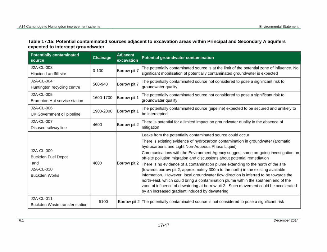
A14 Cambridge to Huntingdon improvement scheme Environmental Statement
6.1 December 2014
17/47
Table 17.15: Potential contaminated sources adjacent to excavation areas within Principal and Secondary A aquifers expected to intercept groundwater
Potentially contaminated source
Chainage Adjacent excavation
Potential groundwater contamination
J2A-CL-003
Hinxton Landfill site 0-100 Borrow pit 7
The potentially contaminated source is at the limit of the potential zone of influence. No significant mobilisation of potentially contaminated groundwater is expected
J2A-CL-004
Huntington recycling centre 500-940 Borrow pit 7
The potentially contaminated source not considered to pose a significant risk to groundwater quality
J2A-CL-005
Brampton Hut service station 1600-1700 Borrow pit 1
The potentially contaminated source not considered to pose a significant risk to groundwater quality
J2A-CL-006
UK Government oil pipeline 1900-2000 Borrow pit 1
The potentially contaminated source (pipeline) expected to be secured and unlikely to be intercepted
J2A-CL-007
Disused railway line 4600 Borrow pit 2
There is potential for a limited impact on groundwater quality in the absence of mitigation
J2A-CL-009
Buckden Fuel Depot
and
J2A-CL-010
Buckden Works
4600 Borrow pit 2
Leaks from the potentially contaminated source could occur.
There is existing evidence of hydrocarbon contamination in groundwater (aromatic hydrocarbons and Light Non-Aqueous Phase Liquid)
Communications with the Environment Agency suggest some on-going investigation on off-site pollution migration and discussions about potential remediation
There is no evidence of a contamination plume extending to the north of the site (towards borrow pit 2, approximately 300m to the north) in the existing available information. However, local groundwater flow direction is inferred to be towards the north-east, which could bring a contamination plume within the southern end of the zone of influence of dewatering at borrow pit 2. Such movement could be accelerated by an increased gradient induced by dewatering
J2A-CL-011
Buckden Waste transfer station 5100 Borrow pit 2 The potentially contaminated source is not considered to pose a significant risk

A14 Cambridge to Huntingdon improvement scheme Environmental Statement
6.1 December 2014
17/48
Potentially contaminated source
Chainage Adjacent excavation
Potential groundwater contamination
J2A-CL-012
Buckden South landfill 5000-5700 Borrow pit 2
This is believed to operate as a dilute and disperse landfill. This potentially contaminated source could have an impact on groundwater
The expected direction of groundwater movement would be towards the north or north-east, potentially bringing a contaminant plume within the southern end of the zone of influence of dewatering at borrow pit 2
J2A-CL-013
Buckden North landfill 4600-5700 Borrow pit 2
This is expected to be a fully designed and secured landfill. It is considered that the potentially contaminated source would not pose a significant risk to groundwater quality
J2A-CL-016
Woolpack Farm landfill
14200-14400
Borrow pit 3
This is not believed to currently be a secured landfill and is expected to operate as dilute and disperse. It has been licenced for inert wastes and information received from the Environment Agency indicates that it does not pose a significant risk to groundwater quality. In addition, the direction of groundwater flow, and thus any minor residual historic contamination plume, is towards the north-east and would be away from borrow pit 3
A14 Cambridge to Huntingdon improvement scheme Environmental Statement
6.1 December 2014
17/49
Ecological receptors
17.4.45 It is envisaged that the sand and gravel deposits do not extend to the Brampton Wood SSSI, with glacial till being the only superficial deposits. The entire area is underlain by Oxford Clay and the woodland located on higher ground some 500m away from borrow pit 1. On that basis, there would be no impact on the hydrogeological functioning of the Brampton Wood SSSI as a consequence of the scheme.
17.4.46 Potential impacts on the Park Road Grasslands are related to a reduction in groundwater levels due to dewatering at borrow pit 2.
Operation
Groundwater flows and associated receptors
17.4.47 During the operational phase, groundwater levels would be allowed to naturally rebound at borrow pit locations 1, 2, 3 and 7, forming new pond features. It is unlikely that there would be any significant long-term impact on groundwater levels in association with the restoration strategy. There would be no long-term impact on secondary receptors.
17.4.48 Groundwater levels would be allowed to naturally rebound at borrow pit 6. In the eventuality of borrow pit 6 reaching the top of the Woburn Sands aquifer, only minor groundwater confined pressures would be released, causing a localised impact of similar magnitude to that occurring during the construction phase.
17.4.49 The presence of embankments and pile foundations could lead to localised compaction of superficial deposits, resulting in localised neutral effects along the scheme, with the exception of the embankment crossing the river Great Ouse.
17.4.50 In the vicinity of the river Great Ouse, detailed design of embankments would probably require ground treatment, soil removal or raft foundations. There could be potential compaction of deposits associated with the river Great Ouse/Buckden Gravel Pits complex. This could result in local disturbances to groundwater flow patterns. However, the available monitoring data indicate that currently shallow groundwater flow direction is towards the river, parallel to the alignment of the planned embankment. This is in accord with what would be expected from the topography. Therefore, it is anticipated that there would be limited disturbance to shallow groundwater flows.
17.4.51 The viaduct pile foundations would be constructed as bored piles of 900mm to 1200mm diameter. The design has assumed a worst case scenario of water levels being at ground level. During the operational phase it is anticipated that groundwater flow disturbances around the viaduct pile foundations would be very localised and minimal.
Groundwater quality
17.4.52 Without mitigation, in the event of accidental spillage potential contamination could migrate through the upper unsaturated zone, reaching the shallow aquifers and impairing groundwater quality. The aquifers are highly vulnerable to surface pollution and there would be a particular risk to the Lenton Bros Ltd groundwater abstraction because of its close proximity to the scheme.
A14 Cambridge to Huntingdon improvement scheme Environmental Statement
6.1 December 2014
17/50
17.4.53 Should the Woburn Sands aquifer become exposed or its protective cover significantly reduced as a result of the excavation of borrow pit 6, in the absence of mitigation, it would remain a direct pathway for potential contamination that could lead to a significant impact on this Principal Aquifer.
17.4.54 Without prior treatment, there is a risk that any abstracted groundwater associated with the contaminated land sources listed in Table 17.15 would contaminate receiving watercourses. Dependant on the sensitivity of the surface water and the degree of groundwater pollution, the ultimate impact could potentially be significant.
Ecological receptors
17.4.55 The sand and gravel deposits do not extend to the Brampton Wood SSSI. Glacial till is the only superficial deposit expected to be present. The entire area is underlain by Oxford Clay and the woodland is located on higher ground some 500m away from borrow pit 1. On that basis, there would be no impact on the hydrogeological functioning of this ecological receptor.
17.5 Mitigation
17.5.1 Mitigation is inherent in the drainage scheme design and founded on the drainage philosophy (described below) incorporating standards and best practice for current highway design. However, there would also be a need for additional mitigation measures outside the highway design to reduce specific impacts. Both of these mitigation types are covered in the following section, respectively for flood risk, surface water and groundwater, leading to the description of residual effects expected following implementation of all mitigation.
Drainage design philosophy
17.5.2 The drainage design for the scheme is outlined in Chapter 3. The three major objectives that must be achieved for the successful drainage of trunk roads are:
the speedy removal of surface water from the carriageway to provide safety and minimum nuisance;
provision of effective sub-surface drainage to maximise longevity of the pavement and associated earthworks; and
minimisation of the impact of runoff on the receiving environment in terms of flood risk and water quality.
17.5.3 The design of the highway drainage for the A14 has achieved these objectives using Standards contained in the Design Manual for Roads and Bridges Volume 4 (Section 2) Part 3. These Standards include:
HD 33/06 – Surface and Sub-surface Drainage Systems for Highways (to be updated as HD33/12).
HD 45/09 - Road Drainage and the Water Environment (Highways Agency, 2009).

A14 Cambridge to Huntingdon improvement scheme Environmental Statement
6.1 December 2014
17/51
17.5.4 This document provides guidance on the selection of types of surface and sub-surface drainage for trunk roads and motorways including their potential for controlling flooding and pollution. The outline design of the scheme follows government guidance and where possible complies with the national best practice guidance on SuDS.
17.5.5 On the A14 the key objectives would be satisfied using the following measures:
Various surface water collection and conveyance systems, including: underground pipes, kerbs and gullies, concrete surface channels, ditches and grassed swales. Systems have been chosen at the outline design stage based on site specific constraints such as topography and available space.
Separate systems of fine or narrow filter drains would be used to collect sub-surface water.
Flood risk would be controlled and reduced using attenuation ponds and storage ditches designed to current standards agreed with the Environment Agency.
17.5.6 Pollution risk would be controlled and minimised using treatment systems that use one (or a combination) of the following processes to capture pollutants:
Sedimentation – the removal of suspended solids (including use of a settlement forebay).
Separation – the removal of solids and non-aqueous liquids (such as oil interceptors).
Vegetated treatment processes (e.g. lined swales and vegetated treatment systems) allowing for filtration, treatment, settlement, adsorption, biodegradation and plant uptake, depending upon the type and combination of systems used locally along the route of the scheme.
Emergency spillage containment.
17.5.7 Selection and outline design of systems has been informed by the calculation of pollution loading and the risk of spillage or flooding. Specific parameters used in the selection of treatment systems include catchment size, drained areas, availability of space, topography, presence of groundwater, soil permeability, existing drainage (along the existing A14) and the proximity of sensitive water and ecological receptors.
17.5.8 It is not feasible to discharge surface water runoff to the ground on this scheme due to the flat topography, high water table and soil impermeability. Consequently, the disposal of surface water runoff would be achieved by discharge to surface water bodies (watercourses and drainage ditches). No highway runoff would discharge directly into natural ponds, lakes or source protection zone (SPZ) 1 aquifers.
17.5.9 There would be no surface water runoff discharged directly to surface water sewers or local highway drains, except along the existing A14 route, realigned local access roads and side roads, and in Huntingdon town centre.
A14 Cambridge to Huntingdon improvement scheme Environmental Statement
6.1 December 2014
17/52
Flood risk and drainage
17.5.10 Floodplain compensation areas are proposed to mitigate for any non-negligible increase in water levels; these areas are indicated in Figure 17.2. Full details of the scheme mitigation are included in the FRA provided in Appendix 17.1.
Construction
17.5.11 Floodplain compensation areas would be constructed ahead of any construction within Flood Zone 3 to ensure no deleterious impact upon flood risk during that phase.
Operation
Fluvial flood risk mitigation
17.5.12 Where a non-negligible potential impact on flood risk has been identified, floodplain compensation would be implemented to reduce or eliminate such risks, including making the necessary allowance for climate change.
17.5.13 New culverts would be designed to convey the 1% AEP event peak flow. They would have depressed inverts to maintain a natural bed.
Highway runoff mitigation
17.5.14 To reduce deleterious impact on flood risk, runoff from the new impermeable carriageway areas would be conveyed to attenuation ponds as part of the drainage scheme. Runoff would be attenuated and discharged to receiving watercourses at greenfield rates to mimic the response of the natural catchment to rainfall. The ponds have been designed to retain the 1% AEP runoff volume plus an allowance for climate change.
17.5.15 The FRA has not identified any other sources of flood risk requiring mitigation.
Surface water – hydromorphology and water quality
Construction
17.5.16 Procedures and mitigation measures to be adopted during the construction phase are defined in the Code of Construction Practice (CoCP) and supplemented by more specific information in this chapter.
17.5.17 All necessary consents and licences would be in place prior to commencement of any works. The works would be carried out in accordance with any conditions imposed.
17.5.18 The risk of pollution during construction would be reduced by adoption of good working practices including strict adherence to the Environment Agency’s guidance on Pollution Prevention Guidelines (PPG) and CIRIA Reports (CIRIA, 2006; CIRIA, 2007; CIRIA, 2001).
17.5.19 Mitigation measures and best practices would be applied prior to and during construction, including:
provision of adequate temporary storage lagoons to contain surface runoff and silt during the construction period
on-site availability of oil spill clean-up equipment including absorbent material and inflatable booms for use in the event of an oil spill or leak;
use of drip trays under mobile plant;

A14 Cambridge to Huntingdon improvement scheme Environmental Statement
6.1 December 2014
17/53
sediment-trapping matting/bunds installed downstream of any construction activities adjacent to or over watercourses;
preparation of incident response plans prior to construction. These would be present on site throughout construction to inform sub-contractors of required actions in the event of a pollution incident;
timing of works close to watercourses, so as not to interfere with spawning fish;
use of site construction materials free from contamination, thereby avoiding any potential contamination of watercourses;
ensuring that wet cement never comes into contact with river or groundwater; and
testing of made and reworked soils to identify any contamination.
Operation
17.5.20 The proposed drainage design incorporates measures to attenuate and treat carriageway runoff (as detailed in Chapter 3). Specifically the following measures would be taken:
swales
balancing and treatment ponds
where required a shut off valve would be incorporated into the design of outfalls further reducing the risk of an impact from the accidental spillage;
operating and maintenance regimes in accordance with Highways Agency operating requirements; and
in the Memorandum of Understating between the Highways Agency and the Environment Agency it is agreed that prior to the use of de-icing agents other than rock salt the Highways Agency should consult with the Environment Agency.
Outfalls
17.5.21 The location of the outfalls along the watercourses would be refined as part of the detailed design. Outfalls have been recommended to be installed at locations that would not excessively alter channel flow and sedimentation patterns. Specific considerations include:
directing each outfall downstream to minimise impacts to flow patterns;
directing an outfall away from the banks of a river to minimise any potential risk of erosion (particularly on the opposite bank); and
minimising the size/extent of the outfall headwall where possible to reduce the potential impact on the banks.

A14 Cambridge to Huntingdon improvement scheme Environmental Statement
6.1 December 2014
17/54
Culverts
17.5.22 Culverts used for crossings over watercourses and water bodies would be designed in detail to include some of the following (Chapter 11 details specific ecological mitigation):
allowing for the passage of water and sediment for a range of flows (including at low flow conditions);
introducing a low flow slot to the bed of the culvert to retain sufficient depth of flow during low flow periods;
maintaining existing channel gradient to avoid erosion at the head or tail (downstream) end of a culvert;
avoiding reduction of river length through shortening of river planform;
keeping the length of a culvert to a minimum and aligning a culvert with the existing watercourse;
depressing the invert of culverts to allow for formation of a more natural bed;
using a culvert of a similar cross-section size to existing (where applicable);
increasing the roughness of culvert inverts to help reduce water velocities;
drowning the downstream end of a culvert to a depth of at least 0.15m to 0.30m;
providing a resting pool of sufficient size and depth immediately downstream of a culvert for fish;
for longer culverts, where depth or velocity is an issue, creating resting places (primarily for fish) using baffles; and
ensuring that culverts were wide enough to allow ledges for passage of animals such as otters where practicable.
Channel Realignments
17.5.23 Any channel realignments would be designed to account for the following:
reduction/increase in the channel length due to alteration of channel planform, potentially impacting channel gradient and consequentially flow and sediment dynamics; and
incorporation of geomorphological and ecological features.

A14 Cambridge to Huntingdon improvement scheme Environmental Statement
6.1 December 2014
17/55
Groundwater
Construction
17.5.24 Mitigation measures that would be required during construction include
re-routing of drains;
re-directing water to recharge a specific ecological site or surface water receptor;
monitoring of surface waters; and
monitoring groundwater abstractions and providing temporary supplies if required during dewatering.
17.5.25 Initial consultation with the Environment Agency indicates that dewatering activities from borrow pit locations do not currently require any consent. It is understood that such requirements could be introduced in the future, although there are no firm plans at present.
17.5.26 Consultation with landowners and abstraction licence holders would be undertaken at the detailed design phase to establish the details of known abstractions and identify any further unrecorded private water supplies in the vicinity of the scheme.
17.5.27 A phase of ground investigation to inform the detailed design (scheduled for late 2014) would also include additional soil and groundwater quality testing. Based on this, water quality monitoring and treatment would be designed as required to ensure no pollution at the discharge location.
17.5.28 A protective layer of Gault Clay would be left above the Woburn Sands Principal Aquifer at borrow pit 6. This would nominally be a minimum of 1m thick; however, the required thickness would be confirmed after completion of the refined assessment following further ground investigation.
17.5.29 Mitigation measures proposed for surface water protection during construction and operation would prevent or reduce potential for contamination of local superficial aquifers and the Woburn Sands aquifer and associated receptors. In addition, water quality from Lenton Bros Ltd abstraction would be monitored during the construction phase to ensure no impacts occurred.
17.5.30 Most of the borrow pit excavations are expected to intercept groundwater. Appropriate mitigation would be put in place to avoid significant adverse effects on the River Terrace Deposits aquifer. The detail of these would be developed during the detailed design stage, but could include limiting the depth of borrow pit working in certain locations, installation of barriers to groundwater movement or working without dewatering.
17.5.31 The appointed contractor would be required to implement the Code of Construction Practice (CoCP) presented in Appendix 20.2. Contractors would also be required to operate in accordance with the Environment Agency’s Pollution Prevention Guidelines.
17.5.32 All fuel, oil and chemicals would be stored in accordance with the requirements of the Control of Pollution (Oil Storage) Regulations 2001.
A14 Cambridge to Huntingdon improvement scheme Environmental Statement
6.1 December 2014
17/56
17.5.33 Site runoff would be captured in temporary drainage arrangements, allowing any silt mobilised during construction to be deposited.
17.5.34 Other possible mitigation measures would include treatment, if required, to ensure no pollution was caused at the point of discharge.
17.5.35 A foundation risk assessment would be required in advance of the river Great Ouse viaduct construction.
Operation
17.5.36 Surface water drainage systems, such as SuDS and swales, would be lined unless the Contractor confirmed an alternative agreement with the Environment Agency during the detailed design phase.
17.5.37 If necessary flood compensation areas would be lined to prevent or limit infiltration to groundwater.
17.5.38 The majority of road runoff would pass through attenuation ponds prior to discharge, trapping sediment. Where a risk is identified, the design also includes devices which would allow isolation of flows in the event of an accidental spillage.
17.5.39 Some of the mitigation measures adopted during the construction phase would also mitigate against potential impacts during the operational phase, such as a protective layer of Gault Clay to be left above the Woburn Sands Principal Aquifer at borrow pit 6.
17.5.40 Other mitigation measures include:
treatment put in place, if required, to ensure no pollution caused at the point of discharge;
mitigate against any impact of settlement; and
monitoring of groundwater abstractions and provision of alternative supplies.
17.6 Significance of effects
17.6.1 This section provides a summary of the significance of the residual effects that would arise after implementation of all of the proposed mitigation described in the previous section, including the drainage scheme design and (where applicable) further mitigation. Tables 17.19 and 17.20 provide a comprehensive summary of residual construction and operational effects (respectively) for all water-related aspects of the scheme.
Flood risk
17.6.2 In the construction phase construction impacts would be fully mitigated by the provision of floodplain compensation and there would not be any likely significant residual effects.
A14 Cambridge to Huntingdon improvement scheme Environmental Statement
6.1 December 2014
17/57
17.6.3 For the operational phase, the likely significant effect of the scheme on flood risk would be neutral for 11 of the 14 watercourses assessed within the FRA. An adverse effect is identified for the following three watercourses:
Ellington Brook;
Brampton Brook; and
River Great Ouse.
17.6.4 The importance of flood risk on the Ellington Brook is deemed to be low as there are no properties within Flood Zone 3 in the vicinity of the scheme. Hydraulic modelling of the impact of the scheme including floodplain compensation has identified that the local access road to the north of the A14 crosses the floodplain which would result in a localised peak rise in 1% (1 in 100) AEP water levels of 0.25 metres. Consequently the magnitude of the impact of the scheme on flood risk as major adverse. The significance of the potential effect has been classified as slight adverse because the water level rise does not affect property.
17.6.5 The importance of flood risk on the Brampton Brook has been classified as low upstream of the scheme due to the limited property in the vicinity and very high downstream due to the proximity of Brampton. Hydraulic modelling of the Brampton Brook assesses the magnitude of the impact of the scheme on flood risk as major adverse upstream and negligible downstream, including the effect floodplain compensation. The crossing of the floodplain by the new A14 results in a peak water level rise of 0.25 metres for the 1% (1 in 100) AEP event immediately upstream of the new road, there is a negligible change to peak water levels immediately downstream which is localised and no change at Brampton. The significance of the potential effect has therefore been classified as neutral downstream and slight adverse upstream because although the water level rise could be classified as ‘large’ it does not affect property. The hydraulic model and consequently the assessment of the scheme’s effect, is due to be refined in the next design phase.
17.6.6 Following DMRB guidance, as described in section 17.2.35, with consideration for the numbers of property within the floodplain upstream of the scheme crossing, the importance of flood risk on the river Great Ouse has been assessed as very high. Hydraulic modelling of the river Great Ouse has been used to assess the magnitude of the impact of the scheme on flood risk. The new crossing would result in a peak water level rise for the 1% (1 in 100) AEP event of 0.02 metres within the floodplain which would represent an impact of minor magnitude and effect of moderate significance. However, it should be noted that this peak rise in water level only affects undeveloped land and not property. The peak water level rise to property for the 1% (1 in 100) AEP event is 7mm, which would be classified as a negligible impact and result in the effect being deemed to be of neutral significance. Taking these points into consideration, the significance of the potential effect has therefore been classified slight adverse, based upon the professional judgement of suitably qualified and experienced specialists, listed in Appendix 6.1.
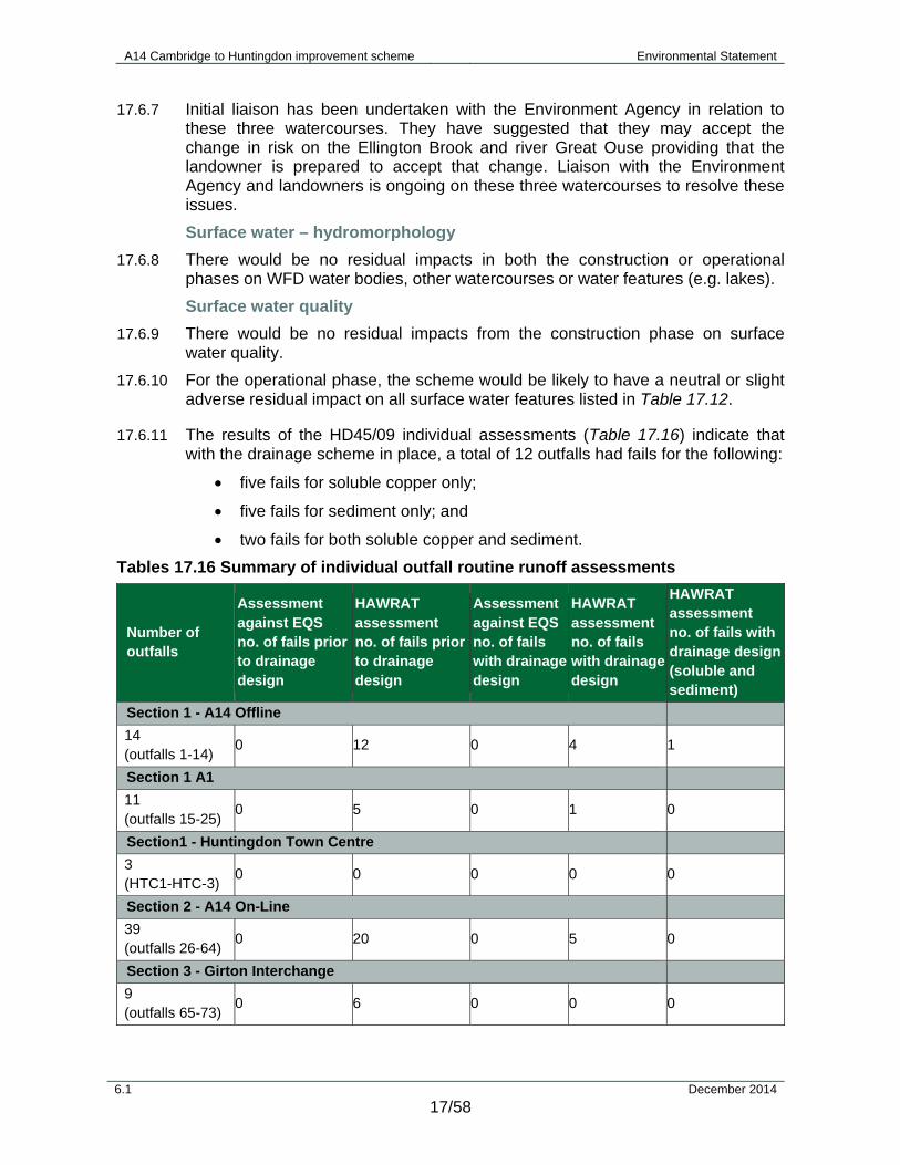
A14 Cambridge to Huntingdon improvement scheme Environmental Statement
6.1 December 2014
17/58
17.6.7 Initial liaison has been undertaken with the Environment Agency in relation to these three watercourses. They have suggested that they may accept the change in risk on the Ellington Brook and river Great Ouse providing that the landowner is prepared to accept that change. Liaison with the Environment Agency and landowners is ongoing on these three watercourses to resolve these issues.
Surface water – hydromorphology
17.6.8 There would be no residual impacts in both the construction or operational phases on WFD water bodies, other watercourses or water features (e.g. lakes).
Surface water quality
17.6.9 There would be no residual impacts from the construction phase on surface water quality.
17.6.10 For the operational phase, the scheme would be likely to have a neutral or slight adverse residual impact on all surface water features listed in Table 17.12.
17.6.11 The results of the HD45/09 individual assessments (Table 17.16) indicate that with the drainage scheme in place, a total of 12 outfalls had fails for the following:
five fails for soluble copper only;
five fails for sediment only; and
two fails for both soluble copper and sediment.
Tables 17.16 Summary of individual outfall routine runoff assessments
Number of outfalls
Assessment against EQS no. of fails prior to drainage design
HAWRAT assessment no. of fails prior to drainage design
Assessment against EQSno. of fails with drainage design
HAWRAT assessment no. of fails with drainage design
HAWRAT assessment no. of fails with drainage design(soluble and sediment)
Section 1 - A14 Offline
14 (outfalls 1-14)
0 12 0 4 1
Section 1 A1
11 (outfalls 15-25)
0 5 0 1 0
Section1 - Huntingdon Town Centre
3 (HTC1-HTC-3)
0 0 0 0 0
Section 2 - A14 On-Line
39 (outfalls 26-64)
0 20 0 5 0
Section 3 - Girton Interchange
9 (outfalls 65-73)
0 6 0 0 0
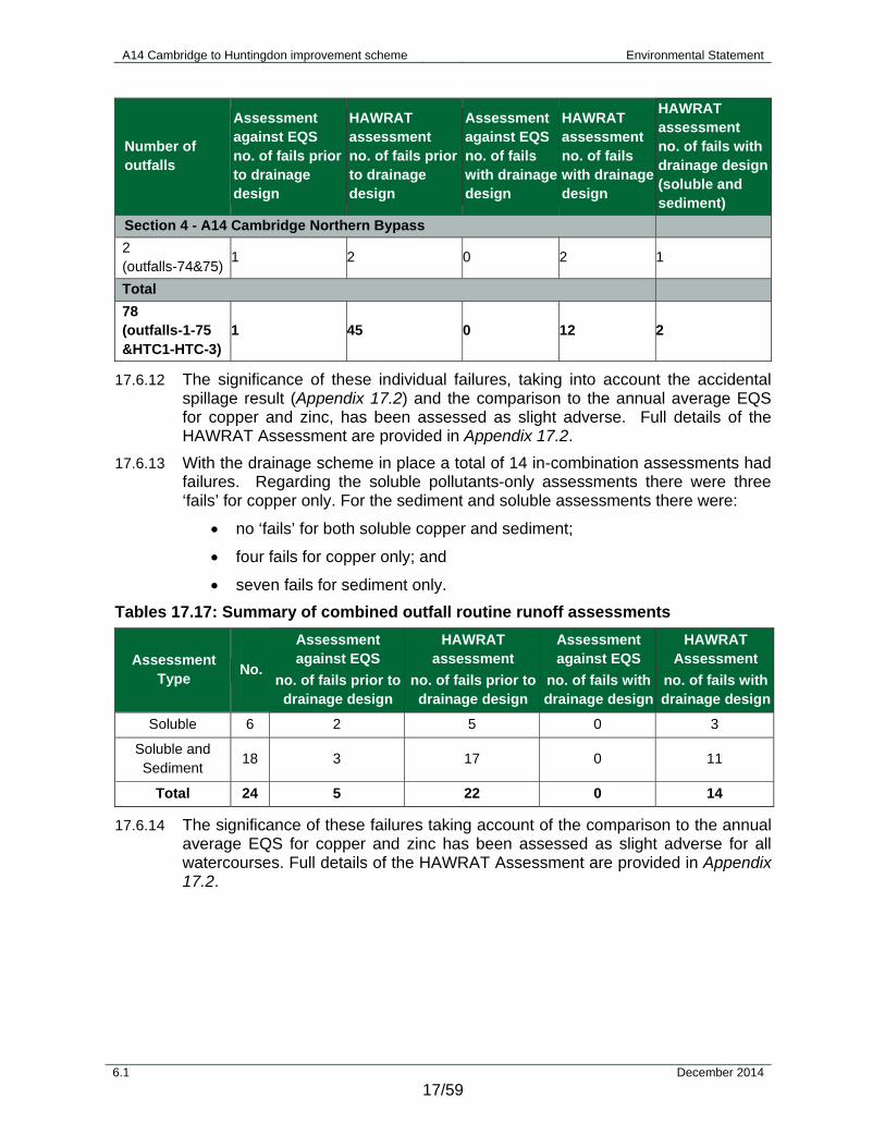
A14 Cambridge to Huntingdon improvement scheme Environmental Statement
6.1 December 2014
17/59
Number of outfalls
Assessment against EQS no. of fails prior to drainage design
HAWRAT assessment no. of fails prior to drainage design
Assessment against EQSno. of fails with drainage design
HAWRAT assessment no. of fails with drainage design
HAWRAT assessment no. of fails with drainage design(soluble and sediment)
Section 4 - A14 Cambridge Northern Bypass
2 (outfalls-74&75)
1 2 0 2 1
Total
78 (outfalls-1-75 &HTC1-HTC-3)
1 45 0 12 2
17.6.12 The significance of these individual failures, taking into account the accidental spillage result (Appendix 17.2) and the comparison to the annual average EQS for copper and zinc, has been assessed as slight adverse. Full details of the HAWRAT Assessment are provided in Appendix 17.2.
17.6.13 With the drainage scheme in place a total of 14 in-combination assessments had failures. Regarding the soluble pollutants-only assessments there were three ‘fails’ for copper only. For the sediment and soluble assessments there were:
no ‘fails’ for both soluble copper and sediment;
four fails for copper only; and
seven fails for sediment only.
Tables 17.17: Summary of combined outfall routine runoff assessments
Assessment Type
No.
Assessment against EQS
no. of fails prior to drainage design
HAWRAT assessment
no. of fails prior to drainage design
Assessment against EQS
no. of fails with drainage design
HAWRAT Assessment
no. of fails with drainage design
Soluble 6 2 5 0 3
Soluble and Sediment
18 3 17 0 11
Total 24 5 22 0 14
17.6.14 The significance of these failures taking account of the comparison to the annual average EQS for copper and zinc has been assessed as slight adverse for all watercourses. Full details of the HAWRAT Assessment are provided in Appendix 17.2.

A14 Cambridge to Huntingdon improvement scheme Environmental Statement
6.1 December 2014
17/60
17.6.15 In addition to the outputs of the HAWRAT assessment it is important to consider the water quality impacts within the context of the existing conditions within the study area. Surface water drainage from the existing A14 currently outfalls into a number of watercourses along the existing route via gullies and carrier pipes running alongside the road and then into cut-off ditches. The existing A1 generally has runoff flowing into filter drains alongside the road and draining into surface water ditches. Runoff is generally not currently attenuated or treated at these outfalls. Existing attenuation ponds are provided only at the junctions and do not serve any of the existing A14 or A1 outside of these junctions.
17.6.16 As part of the scheme, runoff from the A1 and the online section of the A14 would be attenuated and treated (by means of attenuation ponds and swales). It is likely that at these locations there would be an improvement in current baseline water quality conditions (with the proviso that details of the existing drainage schemes on the A1 and A14 are limited). Whilst details of the existing drainage schemes on the A1 and A14 are limited, it can be inferred from comparison of the HAWRAT result prior to mitigation (i.e. without the proposed drainage design) and that with the scheme in place with its associated drainage design, there will be an improvement on current baseline water quality conditions. Section 1 - A1 showed 5 fails and Section 2- 4 had 28 fails prior to mitigation. With the proposed drainage in place this would be reduced to 2 fails for Section 1 - A1 and 7 for Section 2- 4.
17.6.17 Furthermore with vehicles travelling along the new A14 offline section of the scheme (which will have associated attenuation and treatment measures for road run-off), traffic loading on the old de-trunked A14 between Brampton Interchange and the tie in to the existing A14 would be significantly reduced. This would directly reduce the pollutant loading for the following watercourses along the existing A14:
Alconbury and Brampton Brook;
River Great Ouse; and
West Brook.
17.6.18 The river Great Ouse is considered to be of medium importance with the majority of the WFD and non WFD watercourses in the vicinity of the scheme also of medium importance, see Table 17.12. Therefore, the Great Ouse catchment as a whole is considered to be of medium importance. As a result of the scheme, there would be an improvement on the current baseline conditions for water quality of the river Great Ouse catchment as a whole as outlined above. The magnitude of this impact is assessed as minor beneficial as it would reduce the current level of impact from minor adverse to negligible. Therefore the overall significance to the river Great Ouse catchment in terms of water quality as a result of the scheme is assessed as a minor beneficial effect.
Groundwater
17.6.19 The scheme would result in a neutral or slight adverse residual significance of effect for both the construction and operational phases as a result of implementing the identified mitigation measures.
A14 Cambridge to Huntingdon improvement scheme Environmental Statement
6.1 December 2014
17/61
17.6.20 The River Terrace Deposits and associated receptors may be impacted during the construction phase with the dewatering of the borrow pits. However, the significance of these impacts have been assessed as neutral to slight, with implementation of the identified mitigation measures.
17.6.21 Flood compensation areas in the western and central parts of the scheme would be located on areas of River Terrace Deposits. To the east, flood compensation areas would be above the Woburn Sands outcrop area. These features would be designed to reduce local flooding issues by intercepting and temporarily impounding surface water runoff; they would also allow it to infiltrate to groundwater. As a result, there would be a temporary increase in groundwater recharge and elevation of the groundwater surface local to the flood compensation areas.
17.6.22 Due to the disturbance to the shallow groundwater flow system that could be induced by recharge at flood compensation areas, there is a potential for existing in-ground contamination to become mobilised or displaced. However, this would be unlikely to cause any significant issue given the very localised groundwater flow disturbance pattern expected. The nearest potentially polluted groundwater area is localised and some distance away.

A14 Cambridge to Huntingdon improvement scheme Environmental Statement
6.1 December 2014
17/62
Table 17.18: Summary of significance of effects of construction
Water feature(s)
Name Importance Potential impact Mitigation Residual
magnitude of impact
Significanceof effect
Flood risk
Watercourses
Cock Brook Low
Loss of floodplain leading to increase in flood water levels
Provision of floodplain compensation
Negligible Neutral
Ellington Brook Low
Brampton Brook (upstream A1) Low
Brampton Brook (downstream A1) Very High
Grafham Road Drain Low
IDB Drain No. 1 Low
River Great Ouse Very High
West Brook / Hall Green Brook Medium
Oxholme Drain Low Negligible None
Covell's Drain Medium
Loss of floodplain leading to increase in flood water levels
Provision of floodplain compensation
Utton's Drove Drain Low
Longstanton Brook High
Oakington Brook Very High
Beck Brook/Cottenham Lode Low
Washpit Brook Low
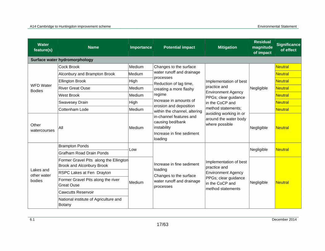
A14 Cambridge to Huntingdon improvement scheme Environmental Statement
6.1 December 2014
17/63
Water feature(s)
Name Importance Potential impact Mitigation Residual
magnitude of impact
Significanceof effect
Surface water hydromorphology
WFD Water Bodies
Cock Brook Medium Changes to the surface water runoff and drainage processes
Reduction of lag time, creating a more flashy regime
Increase in amounts of erosion and deposition within the channel, altering in-channel features and causing bed/bank instability
Increase in fine sediment loading
Implementation of best practice and Environment Agency PPGs; clear guidance in the CoCP and method statements; avoiding working in or around the water body where possible
Negligible
Neutral
Alconbury and Brampton Brook Medium Neutral
Ellington Brook High Neutral
River Great Ouse Medium Neutral
West Brook Medium Neutral
Swavesey Drain High Neutral
Cottenham Lode Medium Neutral
Other watercourses
All Medium Negligible Neutral
Lakes and other water bodies
Brampton Ponds Low
Increase in fine sediment loading
Changes to the surface water runoff and drainage processes
Implementation of best practice and Environment Agency PPGs; clear guidance in the CoCP and method statements
Negligible Neutral Grafham Road Drain Ponds
Former Gravel Pits along the Ellington Brook and Alconbury Brook
Medium Negligible Neutral
RSPC Lakes at Fen Drayton
Former Gravel Pits along the river Great Ouse
Cawcutts Reservoir
National institute of Agriculture and Botany

A14 Cambridge to Huntingdon improvement scheme Environmental Statement
6.1 December 2014
17/64
Water feature(s)
Name Importance Potential impact Mitigation Residual
magnitude of impact
Significanceof effect
Milton Country Park Lakes
Former gravel pits along the river Great Ouse
Surface water quality
All watercourses
WFD water bodies and other watercourses
High
Site clearance and mobilisation works
Earthworks
Accidental spillages of fuel and oil from site plant and use of construction materials
Surface water pollution caused by dewatering of excavations
Dust caused by construction works
Soil storage - these areas would be located at strategic locations along the proposed route (Figure 17.4)
See Section 17.5; includes implementation of best practice and Environment Agency PPGs; clear guidance in the CoCP and method statements; would involve avoiding working in or around the water body where possible
Negligible Neutral
Medium Negligible Neutral
Watercourses Appendix 3.1 High
Construction of culverts Negligible Neutral
Medium Negligible Neutral
Watercourses Appendix 3.1 Medium Watercourse realignments Negligible Neutral

A14 Cambridge to Huntingdon improvement scheme Environmental Statement
6.1 December 2014
17/65
Water feature(s)
Name Importance Potential impact Mitigation Residual
magnitude of impact
Significanceof effect
Watercourses Appendix 17.2 High Construction of
ponds/outfalls
Negligible Neutral
Medium Negligible Neutral
WFD water bodies and other watercourses
River Great Ouse Medium Construction of crossings over watercourses
Negligible Neutral
West Brook Medium Negligible Neutral
Ellington Brook (CS1) High
Disposal of foul water from main compound sites (CS)
Disposal of surface water runoff from CS
Negligible Neutral
Buckden Road Drain (CS2&CS3) Medium Negligible Neutral
HDC Award Drain (CS4) Medium Negligible Neutral
Swavesey Drain (CS5&CS6) High Negligible Neutral
Washpit Brook (CS7) Medium Negligible Neutral
Lake and other Water Bodies
Former Gravel Pits along the Ellington Brook and Alconbury Brook
Medium
Construction work near water bodies
See Section 17.5; includes implementation of best practice and Environment Agency PPGs; clear guidance in the CoCP and method statements; avoiding working in or around a water body where possible
Negligible
Neutral
Brampton Ponds Low Neutral
Grafham Road Drain Ponds Low Neutral
RSPC Lakes at Fen Drayton Medium Neutral
Former Gravel Pits along the river Great Ouse
Medium Neutral
Cawcutts Reservoir Medium Neutral
National institute of Agriculture and Botany
Medium Neutral
Milton Country Park Lakes Medium Neutral
Former gravel pits along the river Great Ouse
Medium Construction across water bodies
Negligible Neutral

A14 Cambridge to Huntingdon improvement scheme Environmental Statement
6.1 December 2014
17/66
Water feature(s)
Name Importance Potential impact Mitigation Residual
magnitude of impact
Significanceof effect
Groundwater
Existing infrastructure
Structures within the zone of influence of dewatering in River Terrace Deposits
Medium Settlement due to groundwater dewatering at borrow pits 1, 2, 3 and 7
Required mitigation measures would include structural reinforcements to mitigate against settlement
Mitigation requirements would be adjusted following receipt and interpretation of further ground investigation data
Negligible or minor adverse
Neutral or slight adverse
Existing infrastructure
Structures within the zone of influence of dewatering in Gault Clay
Medium Settlement due to groundwater dewatering at borrow pit 6.
Not expected to be required
Mitigation requirements would be adjusted following receipt and interpretation of further ground investigation data
Negligible or minor adverse
Neutral or slight adverse
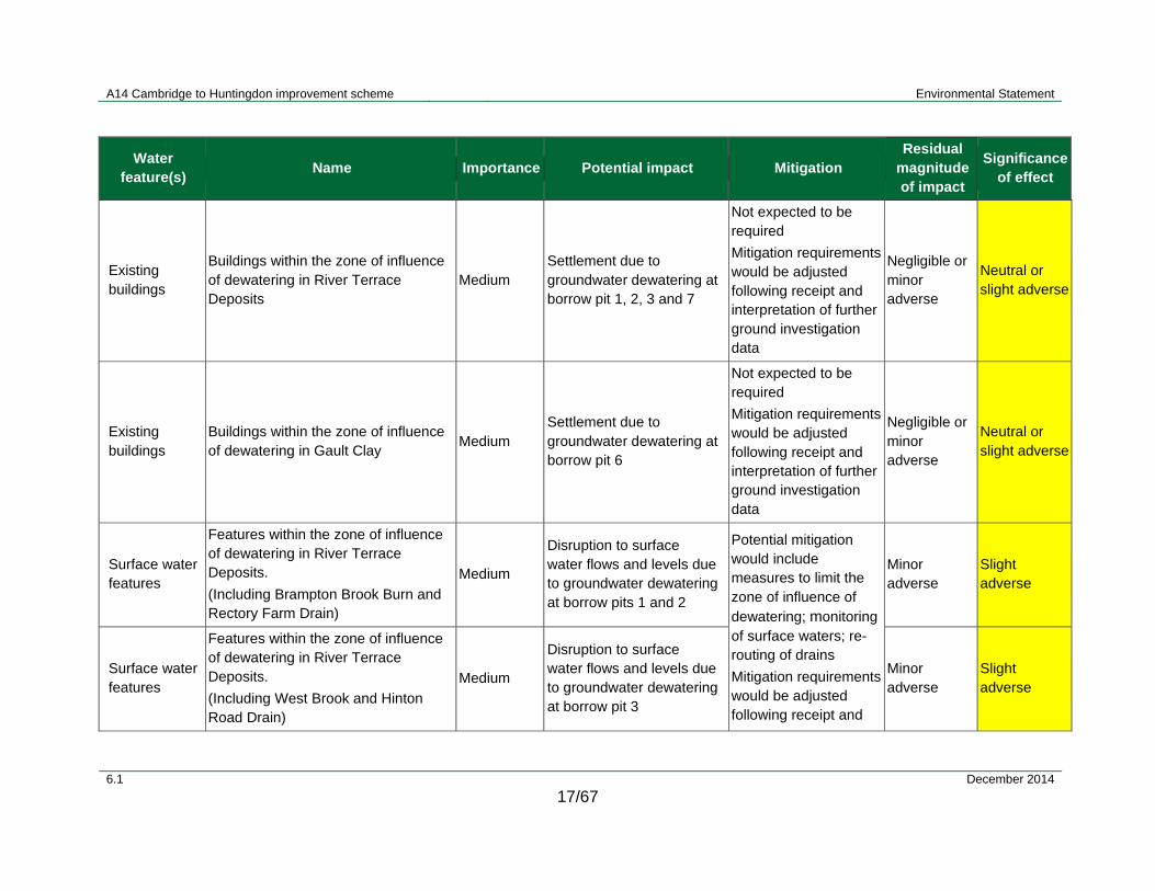
A14 Cambridge to Huntingdon improvement scheme Environmental Statement
6.1 December 2014
17/67
Water feature(s)
Name Importance Potential impact Mitigation Residual
magnitude of impact
Significanceof effect
Existing buildings
Buildings within the zone of influence of dewatering in River Terrace Deposits
Medium Settlement due to groundwater dewatering at borrow pit 1, 2, 3 and 7
Not expected to be required
Mitigation requirements would be adjusted following receipt and interpretation of further ground investigation data
Negligible or minor adverse
Neutral or slight adverse
Existing buildings
Buildings within the zone of influence of dewatering in Gault Clay
Medium Settlement due to groundwater dewatering at borrow pit 6
Not expected to be required
Mitigation requirements would be adjusted following receipt and interpretation of further ground investigation data
Negligible or minor adverse
Neutral or slight adverse
Surface water features
Features within the zone of influence of dewatering in River Terrace Deposits.
(Including Brampton Brook Burn and Rectory Farm Drain)
Medium
Disruption to surface water flows and levels due to groundwater dewatering at borrow pits 1 and 2
Potential mitigation would include measures to limit the zone of influence of dewatering; monitoring of surface waters; re-routing of drains
Mitigation requirements would be adjusted following receipt and
Minor adverse
Slight adverse
Surface water features
Features within the zone of influence of dewatering in River Terrace Deposits.
(Including West Brook and Hinton Road Drain)
Medium
Disruption to surface water flows and levels due to groundwater dewatering at borrow pit 3
Minor adverse
Slight adverse
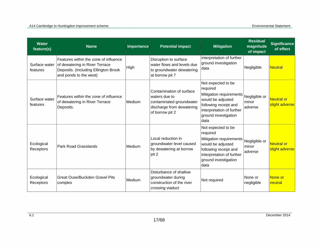
A14 Cambridge to Huntingdon improvement scheme Environmental Statement
6.1 December 2014
17/68
Water feature(s)
Name Importance Potential impact Mitigation Residual
magnitude of impact
Significanceof effect
Surface water features
Features within the zone of influence of dewatering in River Terrace Deposits. (Including Ellington Brook and ponds to the west)
High
Disruption to surface water flows and levels due to groundwater dewatering at borrow pit 7
interpretation of further ground investigation data Negligible Neutral
Surface water features
Features within the zone of influence of dewatering in River Terrace Deposits.
Medium
Contamination of surface waters due to contaminated groundwater discharge from dewatering of borrow pit 2
Not expected to be required
Mitigation requirements would be adjusted following receipt and interpretation of further ground investigation data
Negligible or minor adverse
Neutral or slight adverse
Ecological Receptors
Park Road Grasslands Medium
Local reduction in groundwater level caused by dewatering at borrow pit 2
Not expected to be required
Mitigation requirements would be adjusted following receipt and interpretation of further ground investigation data
Negligible or minor adverse
Neutral or slight adverse
Ecological Receptors
Great Ouse/Buckden Gravel Pits complex
Medium
Disturbance of shallow groundwater during construction of the river crossing viaduct
Not required None or negligible
None or neutral

A14 Cambridge to Huntingdon improvement scheme Environmental Statement
6.1 December 2014
17/69
Water feature(s)
Name Importance Potential impact Mitigation Residual
magnitude of impact
Significanceof effect
Ecological Receptors
Brampton Wood SSSI High
Local reduction in groundwater level caused by dewatering at borrow pit 1
Not required None None
Secondary A Aquifer
River Terrace Deposits High Dewatering of aquifer due to borrow pits 1, 2, 3 and 7
Mitigation measures to limit the zone of influence of dewatering would be implemented
Mitigation requirements would be adjusted following receipt and interpretation of further ground investigation data
Negligible Neutral
Principal Aquifer
Woburn Sands Very High Relatively localised dewatering effects at borrow pit 6
A protective layer of Gault Clay would be left in place above Woburn Sands (nominally 1m thick)
Mitigation requirements would be adjusted following receipt and interpretation of further ground investigation data
Negligible Neutral
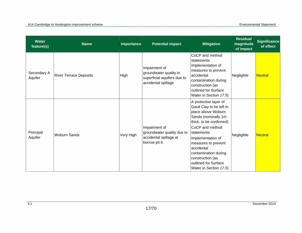
A14 Cambridge to Huntingdon improvement scheme Environmental Statement
6.1 December 2014
17/70
Water feature(s)
Name Importance Potential impact Mitigation Residual
magnitude of impact
Significanceof effect
Secondary A Aquifer
River Terrace Deposits High
Impairment of groundwater quality in superficial aquifers due to accidental spillage
CoCP and method statements Implementation of measures to prevent accidental contamination during construction (as outlined for Surface Water in Section 17.5)
Negligible Neutral
Principal Aquifer
Woburn Sands Very High
Impairment of groundwater quality due to accidental spillage at borrow pit 6
A protective layer of Gault Clay to be left in place above Woburn Sands (nominally 1m thick, to be confirmed)
CoCP and method statements
Implementation of measures to prevent accidental contamination during construction (as outlined for Surface Water in Section 17.5)
Negligible Neutral

A14 Cambridge to Huntingdon improvement scheme Environmental Statement
6.1 December 2014
17/71
Water feature(s)
Name Importance Potential impact Mitigation Residual
magnitude of impact
Significanceof effect
Licenced abstraction
Lenton Bros Ltd Very High
Disruption of licenced abstraction through dewatering effect at borrow pits 1 and 2
Not expected to be required
Mitigation requirements would be adjusted following receipt and interpretation of further ground investigation data
Negligible Neutral
Private water supply
PWS-5, PWS-6 High
Disruption of private water supplies through dewatering effects at borrow pit 3
Mitigation requirements would be adjusted following receipt and interpretation of further ground investigation data
Negligible Neutral
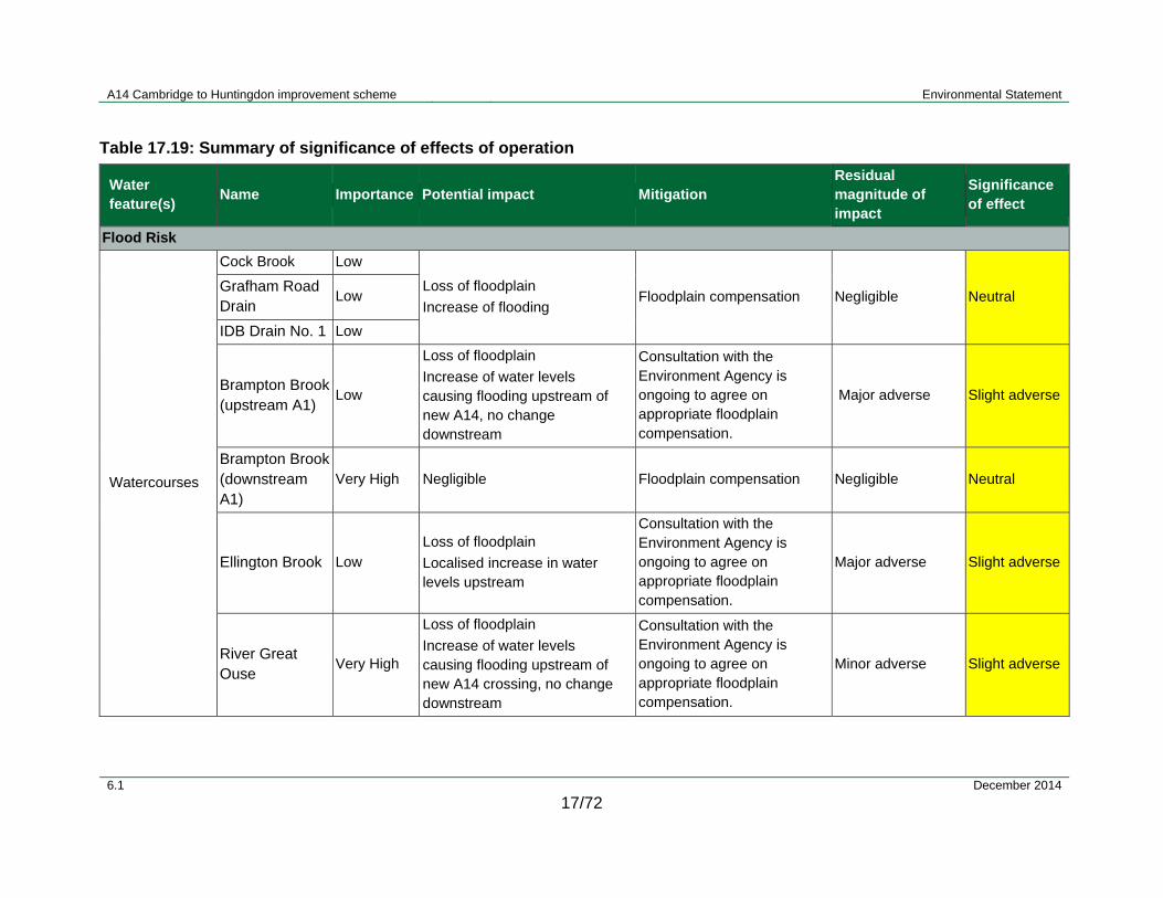
A14 Cambridge to Huntingdon improvement scheme Environmental Statement
6.1 December 2014
17/72
Table 17.19: Summary of significance of effects of operation
Water feature(s)
Name Importance Potential impact Mitigation Residual magnitude of impact
Significance of effect
Flood Risk
Watercourses
Cock Brook Low
Loss of floodplain
Increase of flooding Floodplain compensation Negligible Neutral
Grafham Road Drain
Low
IDB Drain No. 1 Low
Brampton Brook (upstream A1)
Low
Loss of floodplain
Increase of water levels causing flooding upstream of new A14, no change downstream
Consultation with the Environment Agency is ongoing to agree on appropriate floodplain compensation.
Major adverse Slight adverse
Brampton Brook (downstream A1)
Very High Negligible Floodplain compensation Negligible Neutral
Ellington Brook Low
Loss of floodplain
Localised increase in water levels upstream
Consultation with the Environment Agency is ongoing to agree on appropriate floodplain compensation.
Major adverse Slight adverse
River Great Ouse
Very High
Loss of floodplain
Increase of water levels causing flooding upstream of new A14 crossing, no change downstream
Consultation with the Environment Agency is ongoing to agree on appropriate floodplain compensation.
Minor adverse Slight adverse

A14 Cambridge to Huntingdon improvement scheme Environmental Statement
6.1 December 2014
17/73
Water feature(s)
Name Importance Potential impact Mitigation Residual magnitude of impact
Significance of effect
West Brook (Hall Green Brook)
Medium
Minor loss of floodplain
Increase of water levels causing flooding downstream, no change upstream
Floodplain compensation Negligible Neutral
Oxholme Drain Low Negligible None required Negligible Neutral
Covell's Drain Medium Loss of floodplain
Floodplain compensation Negligible Neutral
Utton's Drove Drain
Low
Loss of floodplain
Increase of water levels causing flooding downstream of new A14 crossing, no change upstream
Floodplain compensation Negligible Neutral
Longstanton Brook
High
Loss of floodplain
Increase of water levels causing flooding
Floodplain compensation Negligible Neutral
Oakington Brook
Very High
Cottenham Lode (Beck Brook)
Low
Washpit Brook Low
Surface water hydromorphology
WFD Water Bodies
Cock Brook Medium Outfalls:
Local alteration of channel cross-section and flow dynamics
Directing outfall downstream and away from opposite banks to minimise impacts; minimising size of outfall
Negligible Neutral
Alconbury and Brampton Brook
Medium Negligible Neutral

A14 Cambridge to Huntingdon improvement scheme Environmental Statement
6.1 December 2014
17/74
Water feature(s)
Name Importance Potential impact Mitigation Residual magnitude of impact
Significance of effect
Cottenham Lode Medium Local removal of natural banks and riparian vegetation
headwall Minor Slight adverse
West Brook Medium Negligible Neutral
Alconbury and Brampton Brook
Medium Culvert:
Removing natural channel bed and banks. Altering lateral connectivity with the floodplain. Altering flow processes and patterns of erosion and deposition. Changing natural channel cross-section and replacing with a uniform, artificial channel
Minimising length of culverts and maintaining existing channel gradients, not having a step down from each structure to the natural channel bed
Negligible Neutral
Swavesey Drain High Negligible Neutral
Cottenham Lode Medium Minor Slight adverse
Ellington Brook High Clear Span Bridges:
Localised removal of riparian zones
Inhibiting lateral connectivity with floodplain
Landscaping of surrounding area to minimise loss of riparian zone
Negligible Neutral
West Brook Medium Negligible Neutral
River Great Ouse
Medium Viaduct:
Bridge abutment in floodplain
Landscaping of surrounding area would minimise loss of any riparian zone
Negligible Neutral
Alconbury and Brampton Brook
Medium Channel Realignment:
Changed watercourse length, subsequently altering channel
Input to the design by geomorphologists and ecologists to ensure
Minor Slight adverse
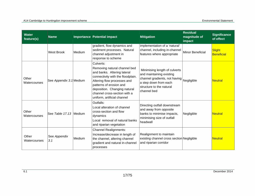
A14 Cambridge to Huntingdon improvement scheme Environmental Statement
6.1 December 2014
17/75
Water feature(s)
Name Importance Potential impact Mitigation Residual magnitude of impact
Significance of effect
West Brook Medium
gradient, flow dynamics and sediment processes. Natural channel adjustment in response to scheme
implementation of a ‘natural’ channel, including in-channel features where appropriate
Minor Beneficial Slight Beneficial
Other Watercourses
See Appendix 3.1 Medium
Culverts:
Removing natural channel bed and banks. Altering lateral connectivity with the floodplain. Altering flow processes and patterns of erosion and deposition. Changing natural channel cross-section with a uniform, artificial channel
Minimising length of culverts and maintaining existing channel gradients, not having a step down from each structure to the natural channel bed
Negligible Neutral
Other Watercourses
See Table 17.13 Medium
Outfalls:
Local alteration of channel cross-section and flow dynamics
Local removal of natural banks and riparian vegetation
Directing outfall downstream and away from opposite banks to minimise impacts, minimising size of outfall headwall
Negligible Neutral
Other Watercourses
See Appendix 3.1
Medium
Channel Realignments:
Increase/decrease in length of the channel, altering channel gradient and natural in-channel processes
Realignment to maintain existing channel cross section and riparian corridor
Negligible Neutral

A14 Cambridge to Huntingdon improvement scheme Environmental Statement
6.1 December 2014
17/76
Water feature(s)
Name Importance Potential impact Mitigation Residual magnitude of impact
Significance of effect
Lake Buckden Gravel Pits
Medium
Removal of an existing gravel pits due to the embankment construction for the river Great Ouse viaduct
Riparian planting where applicable to mitigate for any riparian area lost
Negligible Neutral
Surface water quality
Watercourses and WFD water bodies
See Table 17.13 Medium Routine Road Runoff
Runoff from drainage catchments would pass through drainage systems treating the runoff
Negligible Neutral
Minor Slight adverse
WFD water bodies
Swavesey Drain High Routine Road Runoff
Runoff from drainage catchments would pass through drainage systems treating runoff
Minor Slight adverse
Catchment River Great Ouse
Medium Routine road runoff from existing and new roadway
Runoff from drainage catchments would pass through drainage systems treating runoff
Minor Beneficial Slight beneficial
Groundwater
Secondary A Aquifer
River Terrace Deposits
High
Disturbance due to shallow groundwater flows from embankments (except at river Great Ouse crossing viaduct)
None required Negligible Neutral
Secondary A Aquifer
River Terrace Deposits
High
Disturbance to shallow groundwater flows from embankments at river Great Ouse crossing viaduct
Mitigation requirements would be adjusted following receipt and interpretation of further ground investigation data
Negligible Neutral

A14 Cambridge to Huntingdon improvement scheme Environmental Statement
6.1 December 2014
17/77
Water feature(s)
Name Importance Potential impact Mitigation Residual magnitude of impact
Significance of effect
Secondary A Aquifer
River Terrace Deposits
High
Disturbance to shallow groundwater flows due to river Great Ouse crossing using pile foundations
None required Negligible Neutral
17Secondary A Aquifer
River Terrance Deposits
High
Disturbance to shallow groundwater flows due to A1-A14 link embankments and pile foundations.
None required Negligible Neutral
Secondary A Aquifer
River Terrace Deposits
High Groundwater recharge at flood compensation areas
Lining to prevent/limit infiltration as required
Mitigation requirements wouldbe adjusted following receipt and interpretation of further ground investigation data
Negligible Neutral
Principal Aquifer
Woburn Sands Very High Groundwater recharge at flood compensation areas
Negligible Neutral
Secondary A Aquifer
River Terrace Deposits
High Impairment of groundwater quality in superficial aquifers due to accidental spillage
Implementation of measures to prevent accidental contamination during operation (as outlined for Surface Water in Section 17.5)
Negligible Neutral
Principal Aquifer
Woburn Sands Very High Impairment of groundwater quality due to accidental spillage at borrow pit 6
A protective layer of Gault Clay to be left in place above Woburn Sands (nominally 1m thick, to be confirmed)
Negligible Neutral
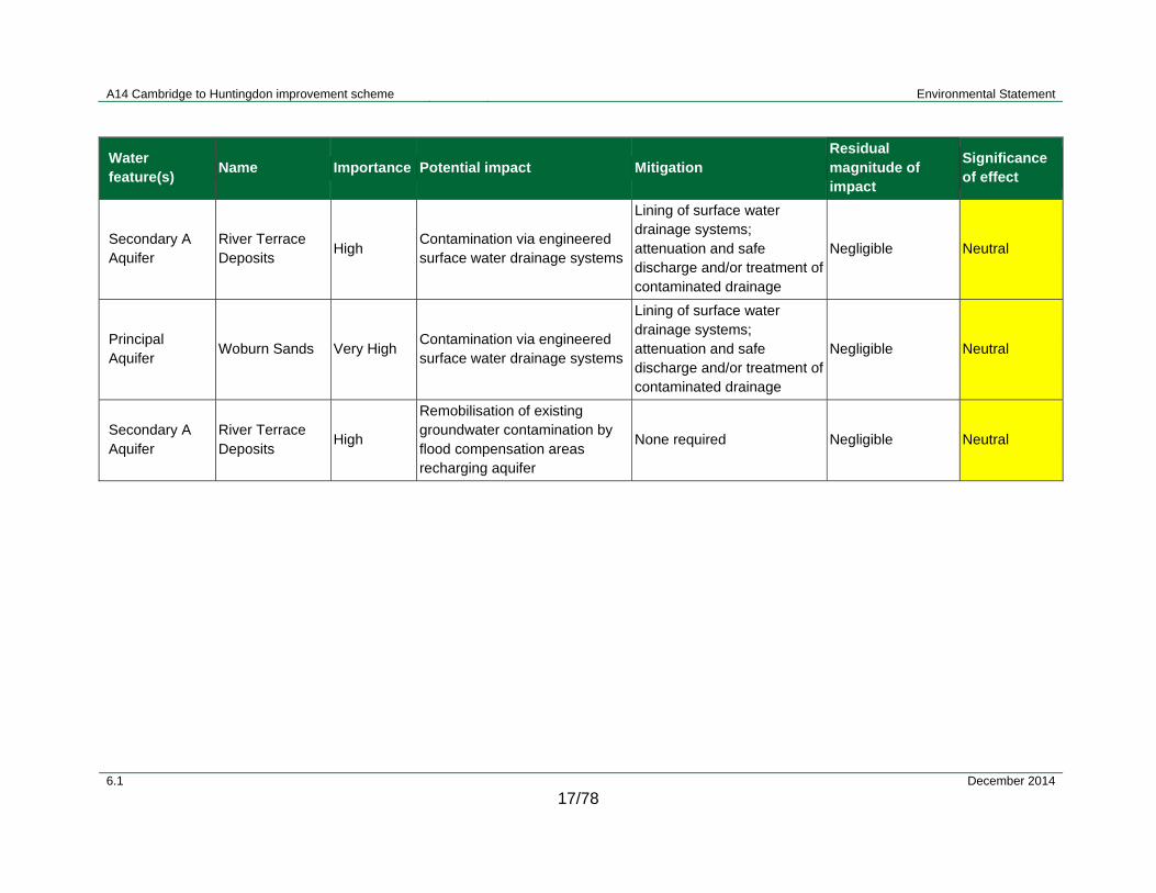
A14 Cambridge to Huntingdon improvement scheme Environmental Statement
6.1 December 2014
17/78
Water feature(s)
Name Importance Potential impact Mitigation Residual magnitude of impact
Significance of effect
Secondary A Aquifer
River Terrace Deposits
High Contamination via engineered surface water drainage systems
Lining of surface water drainage systems; attenuation and safe discharge and/or treatment of contaminated drainage
Negligible Neutral
Principal Aquifer
Woburn Sands Very High Contamination via engineered surface water drainage systems
Lining of surface water drainage systems; attenuation and safe discharge and/or treatment of contaminated drainage
Negligible Neutral
Secondary A Aquifer
River Terrace Deposits
High
Remobilisation of existing groundwater contamination by flood compensation areas recharging aquifer
None required Negligible Neutral

A14 Cambridge to Huntingdon improvement scheme Environmental Statement
6.1 December 2014
17/79
17.6.23 Table 17.20 summarises the overall impact significance for both the construction and operational phases for all the receptors assessed, taking into consideration recommended mitigation (including the scheme drainage design).

A14 Cambridge to Huntingdon improvement scheme Environmental Statement
6.1 December 2014
17/80
Table 17.20: Summary of significance of effects
Description of effect (i.e. how the scheme would change the environment)
Phase (construction or operation)
Mitigation Significance of effect
Flood risk and drainage
Loss of floodplain Operation Provision of floodplain compensation on each watercourse affected as close as possible to the location of loss
Neutral
Increase in flood water levels Operation Provision of floodplain compensation. Slight adverse
Changes to peak runoff rates from increased impermeable area
Operation Provision of attenuation ponds and restriction of peak runoff to Greenfield rates
Neutral
Surface water hydromorphology
Removal of natural bed, banks and in-channel features
Construction Good working practice requirements and standards specified in code of construction practice ; avoidance of working in or around a water body where possible
Neutral
Increase in rates of erosion and deposition, removing existing features and smothering gravels
Neutral
Removal of natural bank material and riparian vegetation
Neutral
Increase in fine sediment loading Neutral
Removal of natural channel cross-section due to implementation of a culvert
Operation Best practice mitigation measures would be incorporated into the design of structures
Neutral
Introduction of surplus flow and a headwall structure due to an outfall
Operation
Best practice mitigation measures would be incorporated into the design of structures
Directing outfall downstream and away from opposite bank to minimise impacts
Minimise size of outfall headwall where possible
Neutral

A14 Cambridge to Huntingdon improvement scheme Environmental Statement
6.1 December 2014
17/81
Description of effect (i.e. how the scheme would change the environment)
Phase (construction or operation)
Mitigation Significance of effect
River realignment Operation Input to the design by geomorphologists and ecologists to ensure implementation of a ‘natural’ channel
Neutral
Removal of riparian zone and lateral connectivity due to a bridges/viaduct structure
Operation
Best practice mitigation measures would be incorporated into the design of structures
Appropriate planting as part of the landscaping would be incorporated as mitigation
Neutral
Water quality
General site clearance, stripping of vegetation and topsoil from the works area
Construction
Implementation of Environment Agency PPG; good working practice requirements and standards specified in code of construction practice ; avoidance of work in or around a water body where possible
Neutral or slight adverse
Construction traffic movements including temporary haul roads
River engineering construction works including watercourse diversions, culverts, crossings and outfalls
Stockpiling of soil
Sewage and surface water generation from site compound facilities
Routine road runoff and accidental spillage within Great Ouse catchment
Operation Implementation of measures to attenuate and treat carriageway runoff
Slight beneficial
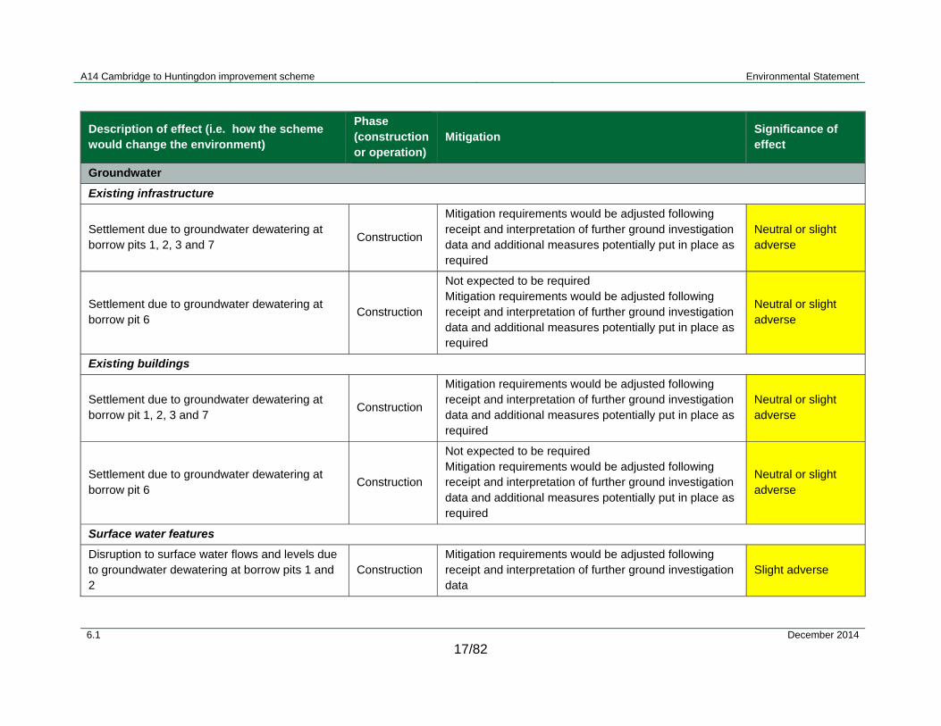
A14 Cambridge to Huntingdon improvement scheme Environmental Statement
6.1 December 2014
17/82
Description of effect (i.e. how the scheme would change the environment)
Phase (construction or operation)
Mitigation Significance of effect
Groundwater
Existing infrastructure
Settlement due to groundwater dewatering at borrow pits 1, 2, 3 and 7
Construction
Mitigation requirements would be adjusted following receipt and interpretation of further ground investigation data and additional measures potentially put in place as required
Neutral or slight adverse
Settlement due to groundwater dewatering at borrow pit 6
Construction
Not expected to be required Mitigation requirements would be adjusted following receipt and interpretation of further ground investigation data and additional measures potentially put in place as required
Neutral or slight adverse
Existing buildings
Settlement due to groundwater dewatering at borrow pit 1, 2, 3 and 7
Construction
Mitigation requirements would be adjusted following receipt and interpretation of further ground investigation data and additional measures potentially put in place as required
Neutral or slight adverse
Settlement due to groundwater dewatering at borrow pit 6
Construction
Not expected to be required Mitigation requirements would be adjusted following receipt and interpretation of further ground investigation data and additional measures potentially put in place as required
Neutral or slight adverse
Surface water features
Disruption to surface water flows and levels due to groundwater dewatering at borrow pits 1 and 2
Construction Mitigation requirements would be adjusted following receipt and interpretation of further ground investigation data
Slight adverse
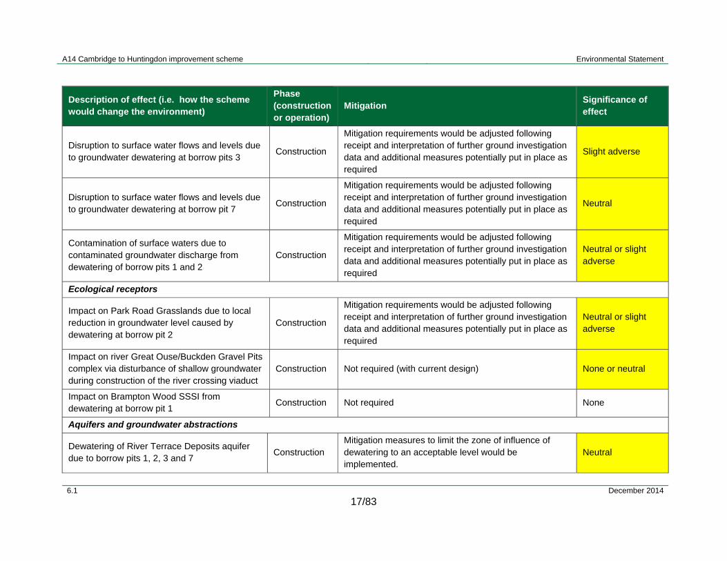
A14 Cambridge to Huntingdon improvement scheme Environmental Statement
6.1 December 2014
17/83
Description of effect (i.e. how the scheme would change the environment)
Phase (construction or operation)
Mitigation Significance of effect
Disruption to surface water flows and levels due to groundwater dewatering at borrow pits 3
Construction
Mitigation requirements would be adjusted following receipt and interpretation of further ground investigation data and additional measures potentially put in place as required
Slight adverse
Disruption to surface water flows and levels due to groundwater dewatering at borrow pit 7
Construction
Mitigation requirements would be adjusted following receipt and interpretation of further ground investigation data and additional measures potentially put in place as required
Neutral
Contamination of surface waters due to contaminated groundwater discharge from dewatering of borrow pits 1 and 2
Construction
Mitigation requirements would be adjusted following receipt and interpretation of further ground investigation data and additional measures potentially put in place as required
Neutral or slight adverse
Ecological receptors
Impact on Park Road Grasslands due to local reduction in groundwater level caused by dewatering at borrow pit 2
Construction
Mitigation requirements would be adjusted following receipt and interpretation of further ground investigation data and additional measures potentially put in place as required
Neutral or slight adverse
Impact on river Great Ouse/Buckden Gravel Pits complex via disturbance of shallow groundwater during construction of the river crossing viaduct
Construction Not required (with current design) None or neutral
Impact on Brampton Wood SSSI from dewatering at borrow pit 1
Construction Not required None
Aquifers and groundwater abstractions
Dewatering of River Terrace Deposits aquifer due to borrow pits 1, 2, 3 and 7
Construction Mitigation measures to limit the zone of influence of dewatering to an acceptable level would be implemented.
Neutral

A14 Cambridge to Huntingdon improvement scheme Environmental Statement
6.1 December 2014
17/84
Description of effect (i.e. how the scheme would change the environment)
Phase (construction or operation)
Mitigation Significance of effect
Dewatering of River Terrace Deposits aquifer due to borrow pits 1, 2, 3 and 7. Water resource availability
Operation Not required None
Dewatering of Woburn Sands aquifer due to borrow pit 6
Construction, Operation
A protective layer of Gault Clay would be left in place above Woburn Sands (nominally 1m thick) Mitigation requirements would be adjusted following receipt and interpretation of further ground investigation data
Neutral
Disturbance to shallow groundwater flows due to embankment except at river Great Ouse crossing viaduct
Operation None required Neutral
Disturbance to shallow groundwater flows due to embankment at river Great Ouse crossing viaduct
Operation Mitigation requirements would be adjusted following receipt and interpretation of further ground investigation data. Impact if confirmed would be difficult to mitigate
Neutral
Disturbance to shallow groundwater flows due to river Great Ouse crossing viaduct pile foundations
Operation None required Neutral
Disturbance to shallow groundwater flows due to A1-A14 link embankments and pile foundations
Operation None required Neutral
Flood compensation recharging shallow aquifer Operation
Lining would prevent/limit infiltration as required. Mitigation requirements would be adjusted following receipt and interpretation of further ground investigation data
Neutral
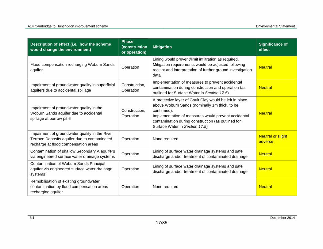
A14 Cambridge to Huntingdon improvement scheme Environmental Statement
6.1 December 2014
17/85
Description of effect (i.e. how the scheme would change the environment)
Phase (construction or operation)
Mitigation Significance of effect
Flood compensation recharging Woburn Sands aquifer
Operation
Lining would prevent/limit infiltration as required. Mitigation requirements would be adjusted following receipt and interpretation of further ground investigation data
Neutral
Impairment of groundwater quality in superficial aquifers due to accidental spillage
Construction, Operation
Implementation of measures to prevent accidental contamination during construction and operation (as outlined for Surface Water in Section 17.5)
Neutral
Impairment of groundwater quality in the Woburn Sands aquifer due to accidental spillage at borrow pit 6
Construction, Operation
A protective layer of Gault Clay would be left in place above Woburn Sands (nominally 1m thick, to be confirmed). Implementation of measures would prevent accidental contamination during construction (as outlined for Surface Water in Section 17.5)
Neutral
Impairment of groundwater quality in the River Terrace Deposits aquifer due to contaminated recharge at flood compensation areas
Operation None required Neutral or slight adverse
Contamination of shallow Secondary A aquifers via engineered surface water drainage systems
Operation Lining of surface water drainage systems and safe discharge and/or treatment of contaminated drainage
Neutral
Contamination of Woburn Sands Principal aquifer via engineered surface water drainage systems
Operation Lining of surface water drainage systems and safe discharge and/or treatment of contaminated drainage
Neutral
Remobilisation of existing groundwater contamination by flood compensation areas recharging aquifer
Operation None required Neutral
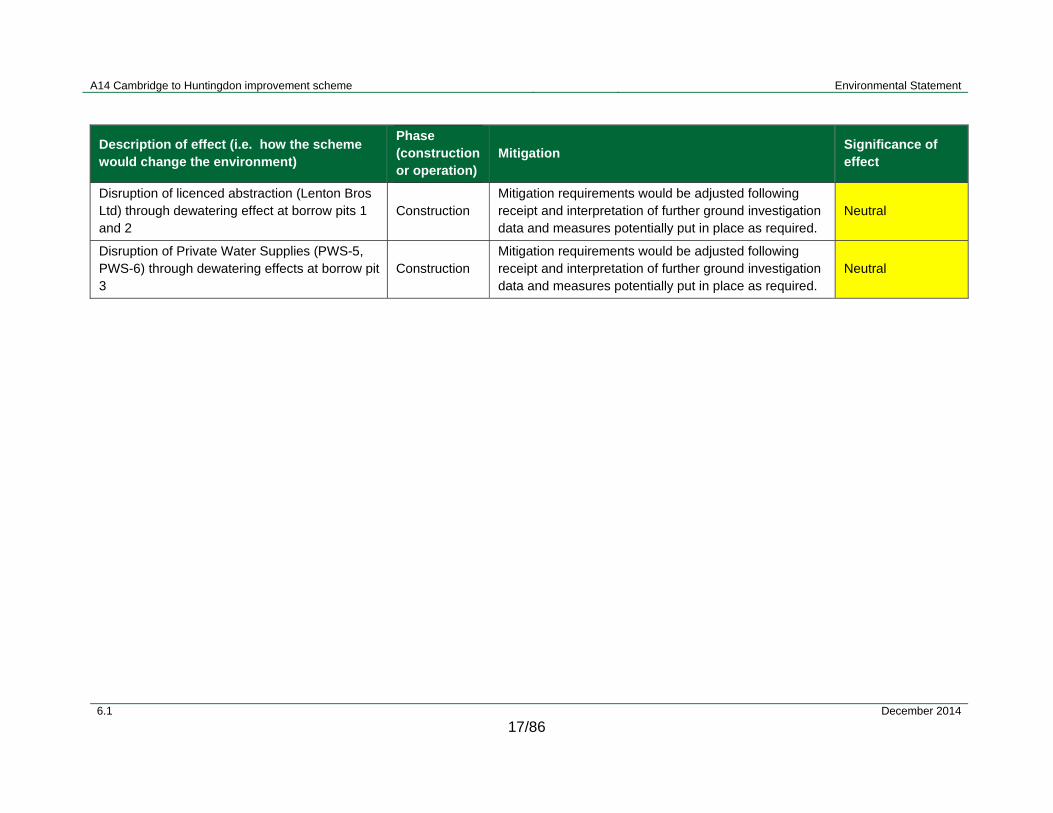
A14 Cambridge to Huntingdon improvement scheme Environmental Statement
6.1 December 2014
17/86
Description of effect (i.e. how the scheme would change the environment)
Phase (construction or operation)
Mitigation Significance of effect
Disruption of licenced abstraction (Lenton Bros Ltd) through dewatering effect at borrow pits 1 and 2
Construction Mitigation requirements would be adjusted following receipt and interpretation of further ground investigation data and measures potentially put in place as required.
Neutral
Disruption of Private Water Supplies (PWS-5, PWS-6) through dewatering effects at borrow pit 3
Construction Mitigation requirements would be adjusted following receipt and interpretation of further ground investigation data and measures potentially put in place as required.
Neutral
A14 Cambridge to Huntingdon improvement scheme Environmental Statement
6.1 December 2014
17/87
17.7 Summary and conclusion
Flood risk
17.7.1 An assessment has been made of existing flood risks to develop a baseline from which to assess potential impacts of the scheme. Hydraulic modelling has been undertaken on watercourses where models are available to determine existing peak flood water levels. Elsewhere flood levels have been obtained from the Environment Agency or estimated from predicted flood extents. The models have then been modified to include details of the scheme to assess likely impact. Where the potential impact has been assessed as adverse, mitigation measures have been incorporated to ensure no deleterious effect upon existing levels of flood risk. There are three watercourses where further investigations are scheduled for the detailed design phase to refine the mitigation measures and consequently the assessment of the scheme’s effect upon flood risk. The highway drainage has been designed to include for attenuation of the additional runoff that would result from the scheme. This would limit discharges to receiving watercourses to greenfield rates to mimic the natural (undeveloped) catchment’s response to rainfall.
Surface water - hydromorphology
17.7.2 Potential hydromorphological impacts have been identified through an assessment of all watercourses including WFD water bodies. This assessment has considered potential impacts in the study area from construction activities and the scheme operation. Potential construction impacts would be mitigated using measures such as the use of temporary silt lagoons and adoption of standard best practices for construction works. It is anticipated that there would therefore be a neutral significance of effect during the construction phase for all watercourses, WFD water bodies, lakes and reservoirs.
17.7.3 During the scheme operation, potential impacts could arise from a number of different structures built close to or within watercourses and water bodies. The structures include: culverts, outfalls, clear span bridges and viaducts. These could have a number of possible impacts, including disconnecting a watercourse from its floodplain, altering a natural channel cross-section and removing riparian vegetation. However, it is anticipated that through implementation of best practices in the detailed design phase and incorporation of mitigation measures (where appropriate) that the effects would have an overall neutral significance.
17.7.4 Channel realignments as part of the scheme could also potentially have an impact. Realignments would be designed to ensure that the channel capacity is not compromised. The potential effects of channel realignment would therefore be expected to have a neutral significance for non-WFD watercourses.
Water Framework Directive Water Bodies
17.7.5 The operational phase would require implementation of culverts, outfalls and clear span bridges and a viaduct, as well as two channel realignments. Potential effects identified as a consequence of these works could include disconnection of the water body from its floodplain due to the presence of new structures, reduction in longitudinal connectivity and removal of natural cross-sections and riparian corridors.

A14 Cambridge to Huntingdon improvement scheme Environmental Statement
6.1 December 2014
17/88
17.7.6 Key mitigation measures detailed for the WFD water bodies would include following best practice guidelines in the design of any structures, reducing the length/size of any culverts or headwalls where possible and ensuring that the lateral and longitudinal connectivity of the water bodies is maintained as far as practicable. Integration of planting as part of the landscaping of the scheme would also help enhance the surrounding riparian area.
17.7.7 As a result, it is anticipated that there would be no deterioration in the ecological status of any of the seven WFD water bodies within the study area. The impacts would be localised and not impact at the water body scale. The significance of effect has therefore been assessed to be neutral.
Surface water quality
17.7.8 Residual effects on water quality taking into consideration the drainage scheme have been assessed and are presented in Table 17.19 and Table 17.20, covering construction and operational phases respectively.
17.7.9 This assessment has found that with the proposed mitigation in place, construction phase effects would be neutral to slight adverse. Based on the outputs of the HAWRAT assessment during operation effects would range from neutral to slight adverse on individual watercourses.
17.7.10 In addition, it is important to consider water quality impacts within the context of the existing baseline of the river Great Ouse Catchment. Many of the watercourses along the existing A1 and A14 are likely to be receiving untreated and un-attenuated discharge at present. These watercourses would receive discharge that has been subject to attenuation and treatment by the scheme. In addition, there would be fewer vehicles travelling along the de-trunked A14 between Brampton interchange and the tie in to the existing A14; as a result, the pollutant loads entering a number of the watercourses along the proposed de-trunked A14 would be reduced. Therefore, as a result of the scheme, there would be an improvement on the current baseline conditions for water quality of the river Great Ouse catchment as a whole and on these individual watercourses. Overall the effect to the water quality of the river Great Ouse catchment as a result of the scheme is assessed as slight beneficial.
Groundwater
17.7.11 An assessment has been undertaken of potential impacts related to groundwater and associated receptors including groundwater abstractions, ecological receptors and surface waters. Key potential impacts would be associated with borrow pit areas where dewatering would be needed during the construction phase, in particular from the River Terrace Deposits aquifer. A number of mitigation measures have been identified. Further ground investigation has been scheduled to support the detailed design phase, during which the impact assessment and the specification of mitigation measures would be refined.

A14 Cambridge to Huntingdon improvement scheme Environmental Statement
6.1 December 2014
17/89
17.8 Bibliography
Atkins / Highways Agency (July 2009) Ellington to Fen Ditton Phase 1a Hydraulic Modelling Report.
Atkins / Highways Agency (2013) Cambridge to Huntingdon Improvement Scheme, Environmental Statement Scoping Report.
Bedford Group (BG) (2014) Plans of the Bedford Group of IDBs Award Drains (received April 2014).
British Geological Survey (2014) website: Available at: http://www.bgs.ac.uk/. Accessed 12 May 2014.
British Standards Institution (2011) Specification for salt spreading on highways for winter maintenance (incorporating corrigendum No.1), Available at: http://www.thenbs.com/PublicationIndex/DocumentSummary.aspx?DocID=304151. Accessed 12 May 2014.
Bruen, M.; Johnston, P.; Quinn, M.; Desta, M.; Higgins, N.; Bradley, C.; Burns, S. (2006). Impact assessment of highway drainage on surface water quality. Synthesis report. Available at: http://www.epa.ie/downloads/pubs/research/water/. Accessed 12 May 2014
Cambridge County Council (CCC, 2011) Cambridgeshire County Council Surface Water Management Plan for Girton (April 2012) and Cambridgeshire County Council Surface Water Management Plan for Cambridge and Milton (November 2011). Available at: http://www.cambridgeshire.gov.uk/info/20099/planning_and_development/49/water_minerals_and_waste/2. Accessed 12 May 2014.
CIRIA (2007). CIRIA Report 697:The SuDS Manual.
CIRIA (2006). CIRIA Report 648: Control of Water Pollution from Linear Construction Sites.
CIRIA (2001). CIRIA Report 532: Control of Water Pollution from Construction Sites.
Costain (2009a) A14 - Ellington to Fen Ditton Section 1 - Final Factual Report, Volume 1. Costain Geotechnical Services, 14th August 2009.
Costain (2009b) A14 - Ellington to Fen Ditton Section 2 - Final Factual Report. Costain Geotechnical Services, 14th August 2009.
Daykin, A. (2011) Email: A14 piezometer readings. Sent 11/03/2011, Adam Daykin, Senior Geotechnical Engineer, Geotechnics Water & Environment, ATKINS, Leeds. (A14 Dataloggers outputs Oct 2009-Feb_2011.xls, 15_A14 Final Piezo monitoring Feb 2011.xls)
Defra (Department for Environment Food and Rural Affairs) (2013) Guidance on complying with the rules for Nitrate Vulnerable Zones in England for 2013 to 2016’, Available at: https://www.gov.uk/government/publications/nitrate-vulnerable-zones-in-england-guidance-on-complying-with-the-rules-for-2013-to-2016. Accessed 15 July 2014.
Defra (2014) Multi Agency Geographical Information for the Countryside (MAGIC) interactive maps, Available at: http://www.magic.gov.uk/MagicMap.aspx. Accessed 10 June 2014.
A14 Cambridge to Huntingdon improvement scheme Environmental Statement
6.1 December 2014
17/90
Department for Transport (2013) Draft National Policy Statement for National Networks, London: The Stationery Office, Available at: https://www.gov.uk/government/uploads/system/uploads/attachment_data/file/263720/consultation-document-draft-national-policy-statement.pdf, accessed 10 June 2014.
Envirocheck Report (2013) A14 Ellington to Fen Ditton. Landmark Information Group report for Atkins, 14 June 2013.
Environment Agency (2009) River Basin Management Plan – Anglian River Basin District, Annex A: Current state of waters. Available at: https://www.gov.uk/government/uploads/system/uploads/attachment_data/file/309796/Annex_A_Current_state_of_waters.pdf. Accessed 10 June 2014.
Environment Agency (2011) Great Ouse Catchment Flood Management Plan, Available at: https://www.gov.uk/government/uploads/system/uploads/attachment_data/file/288877/Great_Ouse_Catchment_Flood_Management_Plan.pdf. Accessed 10 June 2014.
Environment Agency (2013a). Climate change allowances for planners. Available at: https://www.gov.uk/government/uploads/system/uploads/attachment_data/file/296964/LIT_8496_5306da.pdf. Accessed 10 June 2014.
Environment Agency (2013b) Cam and Ely Ouse Abstraction Licensing Strategy, Environment Agency, March 2013. Available at: https://www.gov.uk/government/publications/cams-the-cam-and-ely-ouse-abstraction-licencing-strategy. Accessed 10 June 2014.
Environment Agency (2013c) The Upper Ouse and Bedford Ouse Abstraction Licensing Strategy. Environment Agency, March 2013. Available at: https://www.gov.uk/government/publications/cams-upper-ouse-and-bedford-ouse-abstraction-licencing-strategy. Accessed 10 June 2014.
Environment Agency (2013d) Nitrate Vulnerable Zone data taken from What’s in your backyard - Nitrate Vulnerable Zones interactive map. Available at: http://maps.environment-agency.gov.uk/wiyby/wiybyController?ep=maptopics&lang=_e. .Accessed 12 May 2014.
Environment Agency (2014a) Pollution Prevention Guidelines, Available at https://www.gov.uk/government/collections/pollution-prevention-guidance-ppg. Accessed May-August 2014.
Environment Agency (2014b) ‘What’s in Your Backyard?’, Available at: http://maps.environment-agency.gov.uk/wiyby/wiybyController?ep=maptopics&lang=_e. Accessed 10 May 2014.
Environment Agency (2014c) Email to Ian Coleman, Andrew Brookes (Jacobs): Woolpack Farm Landfill Info. Sent 16/07/2014, Environment Agency.
Highways Agency (2006) Design Manual for Roads and Bridges Volume 4 (Section 2) Part 3 (HD33/06). Available at: http://www.dft.gov.uk/ha/standards/dmrb/vol4/section2/hd3306.pdf. Accessed 10 June 2014.

A14 Cambridge to Huntingdon improvement scheme Environmental Statement
6.1 December 2014
17/91
Highways Agency (2008) Design Manual for Roads and Bridges (DMRB) (2008), Volume 11: Environmental Assessment, Section 2: Environmental Impact Assessment, HD205/08. Available at: http://www.dft.gov.uk/ha/standards/dmrb/vol11/section2/ha20508.pdf. Accessed 10 June 2014.
Highways Agency (2009) Design Manual for Roads and Bridges HD45/09 Road Drainage and the Water Environment (DMRB 11). Available at: http://www.dft.gov.uk/ha/standards/dmrb/vol11/section3.htm. Accessed 10 June 2014.
Department for Communities and Local Government (2012) National Planning Policy Framework, ISBN 9781409834137, Available at: https://www.gov.uk/government/publications/national-planning-policy-framework--2, accessed June 2014.
Department for Communities and Local Government (2014) Planning practice guidance, Accessed at: http://planningguidance.planningportal.gov.uk/blog/guidance/, accessed June 2014.
Huntingdonshire District Council (HDC) (2010) Huntingdon District Council Strategic Flood Risk Assessment Update (April 2010). Available at: http://www.huntingdonshire.gov.uk/SiteCollectionDocuments/HDCCMS/Documents/Planning%20Documents/FRA%20Documents/2010%20report/Hunts%20SFRA%20Update.pdf. Accessed 10 June 2014.
Huntingdonshire District Council (HDC) (2014) Award drain information from Huntingdonshire District Council (received March 2014).
South Cambridgeshire District Council (SCDC) (2014) Plans of the South Cambridgeshire District Council Award Drains (received May 2014).
South Cambridgeshire and Cambridge City Council (SC&CCC, 2010) (2014) South Cambridgeshire and Cambridge City Council Strategic Flood Risk Assessment (September 2010). Available at: https://www.scambs.gov.uk/content/strategic-flood-risk-assessment-september-2010. Accessed 10 June 2014.