
ROAD CATEGORY AND HIERARCHY. ROAD CATEGORY EXPRESSWAY Bukit Kayu Hitam to Johor Bahru FEDERAL ROAD ...
45
ROAD CATEGORY AND HIERARCHY
-
date post
22-Dec-2015 -
Category
Documents
-
view
214 -
download
0
Transcript of ROAD CATEGORY AND HIERARCHY. ROAD CATEGORY EXPRESSWAY Bukit Kayu Hitam to Johor Bahru FEDERAL ROAD ...

ROAD CATEGORY AND HIERARCHY

ROAD CATEGORY
EXPRESSWAY Bukit Kayu Hitam to Johor Bahru
FEDERAL ROAD Interstate national network and complements the
expressway network Route 1 (Kangar to JB) Route II ( West Coast to East Coast) Route III (East Coast-state) Maintenance under the Federal Government and is
done through the State JKR with fund from Federal

ROAD CATEGORY STATE ROAD
Roads within the state Constructed with state funds Maintenance under state government
URBAN AREA ROAD
Local Authority
RURAL AREA ROAD Under the jurisdiction of the District Office


Factors governing alignment
Obligatory points The location should avoid obstructions such as places of
cemeteries, archeological, historical monument, public facilities like schools and hospitals, utility services
Geometric design features Facilitate easy grade and curvature Enable ruling gradient in most sections Void sudden changes in sight distance, especially near
crossings Avoid sharp horizontal curves Avoid road intersections near bend or at the top or bottom of a
hill

Factors governing alignment
Precautions at river and railway crossingsBridges should be preferably be located at
right angles to the river flow, not located on a horizontal curve
Crossing railway lines should avoid intersections at gradient, frequent crossing and recrossing

Factors governing alignment
Topographical control points The alignment, where possible should avoid passing through
Marshy and low lying land with poor drainage Flood prone areas Unstable hilly features Avalanche prone areas
Flat terrain-below 3% Rolling terrain -3 to 25% Mountainous terrain – above 25% A location on high ground should be preferred rather than valley
to avoid cross drainage works

Factors governing alignment
Materials and constructional featuresDeep cutting should be avoidedEarth work is to be balanced; quantities for
filling and excavationAlignment should preferably be through better
soil area to minimize pavement thicknessLocation may be near sources of
embankment and pavement materials

GEOMETRIC DESIGN
Elements of design: Sight distance
The length of road ahead visible to drivers Stopping sight distance Passing sight distance
Horizontal alignment Superelevation rates (0.1 for rural areas, 0.06 for urban) Minimum radius
Vertical alignment Pavement design Intersection and crossing design
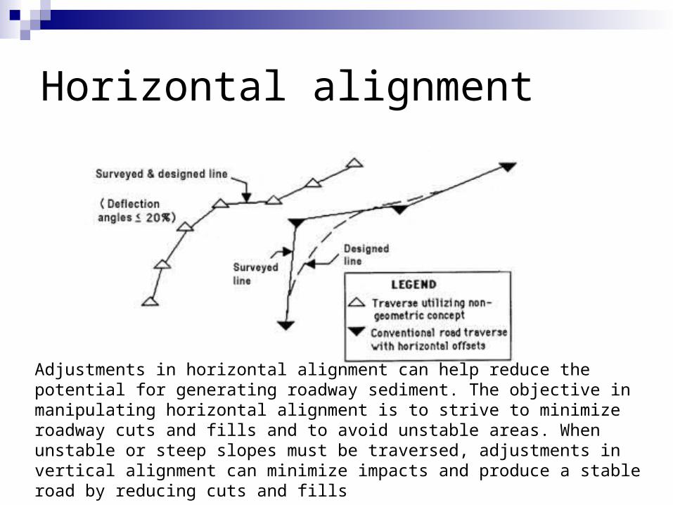
Horizontal alignment
Adjustments in horizontal alignment can help reduce the potential for generating roadway sediment. The objective in manipulating horizontal alignment is to strive to minimize roadway cuts and fills and to avoid unstable areas. When unstable or steep slopes must be traversed, adjustments in vertical alignment can minimize impacts and produce a stable road by reducing cuts and fills

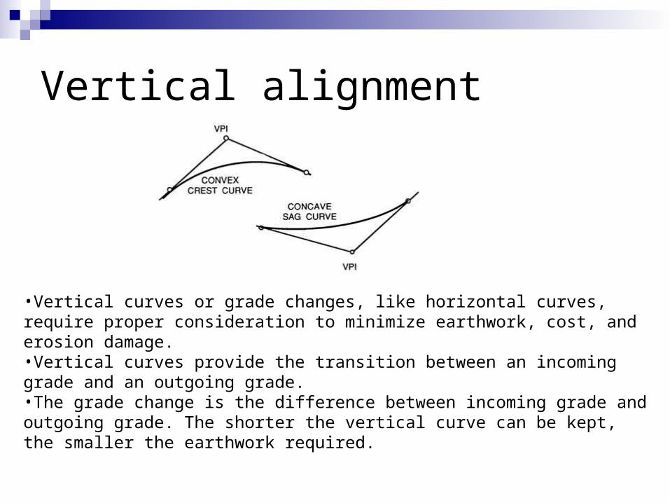
Vertical alignment
•Vertical curves or grade changes, like horizontal curves, require proper consideration to minimize earthwork, cost, and erosion damage. •Vertical curves provide the transition between an incoming grade and an outgoing grade. •The grade change is the difference between incoming grade and outgoing grade. The shorter the vertical curve can be kept, the smaller the earthwork required.

Cross section elements

1. Pavement
Determined by The volume and composition of traffic Soil characteristics
Three general types High
High volume traffic, smooth riding qualities and good nonskid properties in all weathers
Intermediate Slightly less costly and less strength than high type pavement
Low Range from surface treated earth roads and stabilized materials to
loose surface such as earth and gravel
2. Normal cross slope
Cross slope to minimise water ponding on flat sections of uncurbed pavements due to pavement imperfections or unequal settlement
To control the flow of water adjacent to the curb on curbed pavements
2.5% for high surface type 2.5 %- 3.5% for intermediate surface 2.5 % - 6% for low surface

3. Lane widths
3.5 m – normal road width 2.75 m – minor roads and local street 3.5 m – 3.75 m width - Divided highways
4. Shoulder
Emergency stopping free of the traffic lane The sense of openness contributes to driving ease and comfort Sight distances is improved in in cut sections, thereby improving
safety Highway capacity is improved and uniform speed is encouraged Structural support is given to the pavement Minimum 0.6 m should be considered Maximum 3 m for high type facilities Should be sloped sufficiently 2 to 6 % - Bituminous and concrete surfaced shoulders 4 to 6% - gravel or crushed rock shoulders 6 % - turf shoulders

5. Kerbs
Urban areas Drainage control Delineation of pedestrian walkways Aesthetics Two general classes of kerbs;
Barrier kerbs High and steep faced Designed to discourage vehicles from leaving the roadway Should not be used on expressways Should not be used where the design speed exceed 70 km/hr
Mountable kerbs To define pavement edges of through carriageways

6. Medians
Road carrying four or more lanes To provide the desired freedom from the
interface of opposing traffic To provide for speed changes and storage
of right-turning and U-turning vehicles To provide for future lanes

Cross-section of a flexible pavement Wearing course Binder course Road base/ base course Sub base Sub grade

Subgrade
Uppermost part of the soil Natural or imported Supporting the load transmitted from the
overlying layers

Sub base :- Consists of granular materials, either naturally or compacted
or ocassionally stabilized with cement or lime. To disperse the load from the base course before
transmitting it to the subgrade. Help as a drainage layer Prevent moisture migration from subgrade Menahan tanah subgrade dari bercampur dengan road base Sand and aggregate Standard CBR % : Crushed aggregate 30 Sand, Laterite, etc 20

Base course / Road base (1”)
Plays a prominent role in the support and dispersion of the traffic
The thickest layer 3 types :
Crushed aggregatesCement stabilisedBitumen stabilised base courses

Surface course
All the bound layer(s) within the pavement i.e wearing course, intermediate course and binder course
An impermeable and flexible lining of high elastic modulus Hot-mixed bituminous mixtures-consist of well graded mixture of
coarse aggregates, fine aggregates and filler, bound together with bitumen
Binder course Overlying the base course Supporting and dispersing the traffic load Resists shear
Wearing course Topmost layer Resist abrasion and prevent skidding

Drainage system
DRAINAGE is VERY! VERY! VERY! IMPORTANT, both in relation to road pavement construction and maintenance.
Good drainage will help to keep the water table (and strength) of the road pavement in equilibrium.
Water below the road pavement must be kept low and not be allowed to rise up into the construction layers
The road pavement must be constructed so that it will drain in the event of a failure of the integrity of the surfacing layers, i.e. if water is able to enter the road pavement there must be a path for it to exit.

Important of surface drainage
Softening the road surface when it is constructed of soil or sand-clay or gravel or water bound macadam
Washing out unprotected areas of the top surface, erosion of side slopes forming gullies, erosion of side drain
Generally softening of the ground giving rise to land slides or slips
Softening the subgrade soil and decreasing its bearing power

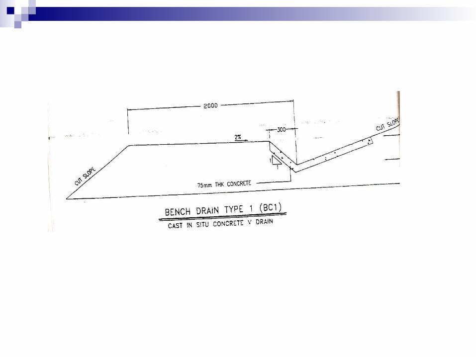
Drainage systems

Components of surface drainage
Shoulder slope Roadside drain/ shoulder drain Toe drain Bench and Berm drain Interceptor drain Out fall drain Median Drain Kerb drain


Road construction
Three stagesStage I – Construction of road formation, i.e
earthworkStage II – Construction of the pavement
structure and drainageStage III – Provision of traffic engineering
facilities

Road construction
Typical road construction equipment Plant for clearing- bull dozers, tractors Plant for drilling/ripping Plant for each mining and moving process-
mechanical showels bulldozers, scrapers, trucks Plant for formation construction-graders, scrapers,
bulldozers Compaction plant-rollers of various types tracked,
smooth, or rubber tyred Bituminous mixing plant

Site Preparation Services
Land clearing including demolition and environmentally advanced recycling and disposal.
Grading and earth work. Storm water drainage, retention ponds, and erosion
control. Road curbing and gutters. Road construction including asphalt, paving,
resurfacing, seal coating and striping. Site utility work including water and sewer lines. Trucking services, heavy and specialized hauling, dump
truck services for dirt and stone.

Earth work
Cut/fill Cut and fill – involve the cutting or excavation of earth materials
and the compaction as fill in conformance. Fill is placed in horizontal lifts and then each lift of fill is
compacted to setup a uniformly compacted material. Fill materials - Only suitable materials such as medium stiff
clays, clayey sand or other approved soils shall be used for filling
Materials from swamps, top soils and other highly organic clay or silts, materials containing boulders materials, materials with chemical composition or at their moisture content will not compact properly shall not be used for filling

Soil compaction Process by which a mass of soil
consisting of solid soil particles, air and water is reduced in volume by momentary application of loads, such as rolling, tamping or vibration
Compaction of the soil generally increases its shear strength, decreases its compressibility and decreases its permeability

Max.drydensity
Drydensity
Zero-air-voidsline (100%saturation)
Optimum m/cOptimum m/cOptimum m/c
Moisture ContentMoisture ContentMoisture ContentMoisture Content
Fig.1

Fill widening Fill widening of 0.30 m are recommended where fill slope height is less than
2.00 m. Fill slope height in excess of 2.00 m should have 0,60 m of fill widening. Fill slope height in excess of 6.00 m should be avoided altogether because
of potential stability problems.
Road construction
Compacting subgrade Rolling using 8-10 t smooth wheeled roller Rolling continued till 100% maximum dry density is achieved and
the surface appears to be well closed Spreading coarse aggregates
The required amount of course aggregates is spread uniformly on the prepared foundation
Using a 6-10 t smooth wheel roller / equivalent capacity vibratory roller.
Bituminous road construction Binder coarse Wearing coarse
Discussion topics
1. What are the factors controlling alignment of roads2. What are the important engineering characteristics of
soils that are likely to influence the performance of a road?
3. Discuss the basic principles of field compaction. Can climatic conditions influence compaction in road construction?
4. Pavement deterioration; causes and rehabilitation5. A properly designed highway requires a well-designed
drainage system