River Restoration and Geomorphology Training workshop · Nevertheless, research in fluvial...
36
River Restoration and Geomorphology Training workshop Wednesdy 25 th April 2001 Britannia Hotel, Coventry City Centre Organised by the River Restoration Centre The River Restoration Centre Silsoe Campus Silsoe Beds MK45 4DT Tel/fax: 01525863341 Email: [email protected] www.theRRC.co.uk
Transcript of River Restoration and Geomorphology Training workshop · Nevertheless, research in fluvial...

River Restoration and GeomorphologyTraining workshop
Wednesdy 25th April 2001Britannia Hotel, Coventry City Centre
Organised by the River Restoration Centre
The River Restoration CentreSilsoe Campus
SilsoeBeds
MK45 4DTTel/fax: 01525863341
Email: [email protected]

2
Introduction:
Programme of Events
Tuition Session 1: The Basics of Geomorphology
Geomorphology in a Catchment ContextProfessor Malcolm Newson
The Basics of River Channel Morpho logy and BehaviourProfessor Chris Soulsby
Tuition Session 2: Linking Geomorphology to Nature Conservation andEngineering
Geomorphology and EcologyDr David Gilvear
Geomorphology and EngineeringProfessor Colin Thorne
Tuition Session 3.: Geomorphology and Data Collection
The Need for and Ways of Obtaining Relevant Geomorphic DataDr David Sear
Afternoon workshop sessions
Workshop Groups 1and 2: Lowland Rural Watercourse – Restoring meanders andpools and rifflesThe ChallengeWhat actually happened
Workshop Group 3: Lowland Urban Watercourse – Enhancing an urbanwatercourseThe ChallengeWhat actually happened
Workshop Group 4: Upland Rural Watercourse – Creation of an environmentallyacceptable channelThe ChallengeWhat actually happened
Page
3
4
6
8
10
12
15
1923
2629
3134
CONTENTS

3
Aim of the workshop
The focus of the day was to emphasise the need for sound geomorphological assessment in riverrestoration. It is hoped that participants have gained an understanding of the complexity of the fluvialsystem and are now in a better position to recognise situations where there is the need to call uponexpert geomorphological assistance.
Overview
Participants were introduced to Fluvial Geomorphology through 5 expert led tuition sessions. Theseincluded sediment transfer, river stability and change, impacts on ecology and engineering, and datacollection.
Short presentations were invited to either illustrate various examples of geomorphology in practice, ordiscuss current projects in need of geomorphological input.
Through group work participants addressed a specific restoration/enhancement opportunity (lowlandrural, lowland urban, upland rural). The aim of the group work was to develop proposals for thesubject reach and discuss decisions and rationale.
To provide an overview of the needs of different river types, group scenarios were summarised,followed by the presentation of all three ‘actual’ case studies to ALL participants, outlining thegeomorphological approach to the design.
The following document provides summaries of the presentations given in the morning session and ofthe case study workshop sessions in the afternoon.
RIVER RESTORATION ANDGEOMORPHOLOGY TRAINING WORKSHOP
The River Nith Workshop Group led by Dr David Gilvear

4
PROGRAMME
Wednesday 25th April 2001 (Connaught Suite)
9:30 Coffee and registration for workshop sessions(Three Spires Suite)
10.00 Introduction Dr David Sear
10:15 Tuition Sessions
The basics of geomorphology
Geomorphology in a catchment context• The fluvial system• Sediment transfer through catchments
Prof. Malcolm Newson
The basics of river channel morphology and behaviour• Stability of different rivers in different environmental settings• Channel widening and braiding
Prof. Chris Soulsby
Linking geomorphology to nature conservation and engineering
Geomorphology and ecology• Geomorphic processes that control in-stream biota and riparian
vegetation
Dr. David Gilvear
Geomorphology and engineering• Sediment transport and engineering structures
Prof. Colin Thorne
Geomorphology and data collection
The need for and ways of obtaining relevant geomorphic data• Existing geomorphic data held within organisations• Methods of stream reconnaissance• Specific information for channel design• Sediment traps
Dr. David Sear
11:30 Short presentations
An opportunity for delegates to raise specific examples with thegeomorphologists present. Discussing either current work in need ofgeomorphogical input/assessing or presenting work wheregeomorphology has played an important role.
Open
PROGRAMME OF EVENTS

5
12.10 General Discussion Prof. Chris Soulsby
12.30 Lunch
Delegates split into workshops
1.30 Workshops (Syndicate Rooms)
These will centre on 3 case studies.
Workshop Group 1 - Lowland rural watercourse - restoring meandersand pools and riffles (Courtyard Suite)Workshop Group 2 - Lowland rural watercourse - restoring meandersand pools and riffles (Pine Suite)
Dr David Sear
Prof. Malcolm Newson
Workshop Group 3 - Lowland urban watercourse - enhancing an urbanwatercourse (Connaught Suite)
Dr Helen DangerfieldDr Kevin Skinner
Workshop Group 4 - Upland rural watercourse - creation of anenvironmentally acceptable channel (Cavendish Suite)
Dr. David GilvearDr. Katherine Leys
Details will be circulated and a presentation of the problem will begiven by the facilitator. Small workgroups will be charged withassessing and designing the project.
2:30 Group presentations over Coffee
Each workgroup will present their proposals and the rationale behindtheir decisions.
Delegates reconvene
3:15 Project reporting and reality (Connaught Suite)The workshop leaders will summarise the groups proposals.The workshop leaders will present a brief report of what actuallyhappened, successes and failures.
Lowland Rural Dr. David SearLowland Urban Dr Helen DangerfieldUpland Rural Dr. David Gilvear
4.30 Summary
The need for sound geomorphological assessments in river restoration. Prof. Malcolm Newson
4:45 Close Martin Janes
Speakers/facilitators
Dr David Sear (University of Southampton)Prof. Malcolm Newson (University of Newcastle)Prof. Chris Soulsby (University of Aberdeen)Dr David Gilvear (University of Stirling)Prof. Colin Thorne (University of Nottingham)Dr Helen Dangerfield (Babtie Group Ltd)Dr Kevin Skinner (University of Nottingham)Dr Katherine Leys (Scottish Natural Heritage)

6
Malcolm Newson, Department of Geograhy, University of Newcastle-upon-Tyne, Daysh Building,Claremont Road, Tyneside, NE41 7RU,Tel:0191-222-6425, Email [email protected]
The Fluvial System - its processing of sediments to make channel formThe context for all sustainable river rehabilitation and restoration
The catchment is the basic unit for sediment supply and the flows to transport it (98% of both); we understandthe key system variables and know the ‘usual outcomes’ but the full picture of sediment storage, supply andtransport is only decipherable in big floods or during decades of observation or measurement.
It therefore becomes necessary to• make the best possible effort to gain a catchment-wide picture;• locate, map and attempt to quantify the main active sediment ‘packages’;• apply the best predictive techniques to processes operating in a given reach.THESE CORRESPONDED WITH RECOMMENDED GEOMORPHOLOGICAL PROCEDURES IN USE BYENVIRONMENT AGENCY
Sediment supply is of vital concern in the UK environment - transport in the channel network is seldomlimiting to sediment throughput, even if it is ‘jerky’ in time. Optimum flows for sediment transport and theformation of channel dimensions tend to be floods which fill the channel but the full flow range impacts onforms via longer-term processes, like deposition. River channels have memory (forms endure changes) - thedegree to which memory dominates response is vital.• Sediments are released for transport by digging them up (i.e. human development activities)!• Sediments are bound by moist, cohesive soils and a natural vegetation cover;• From river banks, sediments are released by many more processes than just river scour e.g. slip,
freeze/thaw;• From river beds, sediments may be hard to transport because of armour/structure
Sediment transport is far from exact science!Given AVAILABILITY, stream-power provides some good clues as to ‘stability’ and sediment loads but saysnothing about channel forms and for scientific rehabilitation we really need to know more than ‘will the restoredchannel be stable?’ - we really need to get a handle on sediment transport at the biotope scale to describe howinstream physical habitat performs in a dynamic way.
Observations and data in fluvial geomorphology - some of this is ‘bird-spotting’ but much is not! - bewarethat simple observations may come easy but linkages need experience. Observations within the same system arelikely to be most value in guiding the restoration contexts at a site (unless you use an undamaged neighbour);We can group the necessary techniques via the geomorphological procedures:
a. Catchment Baseline SurveyList all likely documentary sources of e.g.• geology/soils;• land-use (now and past);• published geomorphological papers;Plus obvious (e.g. EA) national archives• River Corridor Surveys - (under-utilised given channel dimensions and erosion sites listed);• River Habitat Surveys
Tuition session 1: The Basics of GeomorphologyGeomorphology in a Catchment context

7
b. Fluvial AuditGotta get out there!• 50%+ must be walked - use every opportunity to get all poss. Info - heavy backpack or good camera!• Produce 1:10,000 map of all relevant features - including catchment sourcesBut also plenty of background work to do indoors:• Records of floods, maintenance etc : diary!
c. Dynamics AssessmentReserve for the selected reaches, but extend upstream and downstream of project reaches.• Professional field survey (EDM, GPS) of the channel dimensions (width, depth, slope) according to how
they vary - plan it first!• Sediment size data in detail;• ‘Energy data’ - flood marks, backwater etc.• Bank erosion using EA 1999 guidance
ConclusionsExcellent schemes of channel restoration or rehabilitation are possible without a formal geomorphological input(but most of them are in fact informed by excellent local knowledge which includes informal elements of whatis described here!). However, we live in a responsible science-guided society which attempts to set standardsand to explain failures; of the scientific contexts available for river restoration planning and actions, fluvialgeomorphology provides a robust, empirical, understandable body of information.EA and SNH have provided a lead in employing academic geomorphologists to provide R&D, simple guidesand training courses; in future a web-based training system is likely to be available and meanwhile sitesproduced in the USA and in Australia can be found using simple search procedures.

8
Professor Chris Soulsby, Department of Geography and Environment, University of Aberdeen. AB243FXEmail: [email protected]
River channel morphology and behaviour: a brief introduction
1. Introduction
River channels display widely varying characteristics in both space and time. Partly this reflects theirgeographical location within a particular catchment and fluvial system. However, it also reflects the interactionof a range of controlling factors, some of which may operate at the catchment scale, some of which may bemore localized. This brief presentation aims to:
• outline the main physical processes and characteristics which influence channel morphology.
• examine how river channels behave in response to changes in these controlling factors.
• demonstrate how some channels may be relatively stable and insensitive to change, whilst others may behighly dynamic and responsive.
The overall objective is to provide delegates with some background context to help in assessing case workwhere there may be particular problems (eg unstable channels) or management proposals which raise concernsover environmental impacts.
2. Controls on channel morphology
Catchment contextRiver channels are intimately linked to their catchments. Thus at the macroscale, the geographical location of aparticular catchment determines its climate, geology, topography, soil cover and land use. In turn, thesecharacteristics determine the delivery of water and sediment to the river channel.
Driving variablesThe volume and timing of water fluxes to the channel network determines a catchments hydrological regime andis usually closely linked to the volume, timing and nature of sediment fluxes.
Boundary conditionsAs water and sediment is transferred through a channel network, often in an irregular and unsteady mannerduring high flow events, physical forces act upon the material comprising the channel bed and banks (includingvegetation) to sculpt the channel morphology.
CHANNEL CHARACTERISTICSThe morphological characteristics of river channels include; (i) the plan form, (ii) cross-sectional characteristicsand (iii) channel gradient or long-profile.
3. River channel types
The interaction of catchment geography, driving variables and particular boundary conditions create an almostbewildering array of river channel morphologies. However, there are a range of typologies or classificationschemes which seek to group particular channel types and establish functional relationships with theircontrolling factors. Unfortunately, deterministic and quantitative predictions of stream behavior are usually only
Tuition session 1: The Basics of GeomorphologyThe Basics of River Channel Morphology and Behaviour

9
available at intensively studied research sites. Nevertheless, research in fluvial geomorphology means that someof the functional relationships between channel morphology and controlling variables are sufficiently wellunderstood to allow qualitative predictions of the likely impacts of changing the main driving variables andboundary conditions on channel characteristics.
4. River channel change
EQUILIBRIUM IN RIVER CHANNELSEven in undisturbed catchments, river channel morphology changes through time. In most cases, however, thetimescales over which major changes become evident are relatively long (i.e. centuries, millennia etc.), thus onthe timescale of human experience river channels appear to be stable or in equilibrium (or more properlymetaequilbrium). This does not mean that a river doesn’t erode its bed or banks, but that this erosion is usually arelatively slow process, with the channel morphology only changing gradually as the river adjusts to transferwater and sediments.
GEOMORPHOLOGICAL SENSITIVITYWith increasing human activity affecting virtually all river basins, however, all the main influences on channelmorphology are potentially susceptible to change. In some cases channels may be relatively insensitive to suchchanges (eg. bedrock-lined channels or armoured cobble-bed rivers with well vegetated cohesive banks. In othercases, channels may be highly susceptible to change , should some threshold in the state of a controllingvariable be exceeded. For example, in the uplands, many channel networks have become increasingly unstableover the last few hundred years as high grazing densities have changed catchment vegetation, increased runoffrates and increased sediment inputs into river channels. Channel changes may be manifest in a number of waysas the rivers adjust to changes in driving variables or boundary conditions , for example, upland channels maychange their width, depth and paln form in response to increased erosion and runoff.
5. Implications for channel management
Even at this very simple level it is clear that the influences on channel morphology and behaviour are relativelycomplex, but can be sensitive to anthropogenic influences. In many instances, various kinds of activities impacton river channels directly or directly through influence on controlling variables. Examples of the former areflood defence schemes, fishing habitat modification, riparian management and bank protection works. Examplesof the latter include land use change, stocking densities and agricultural drainage schemes. Whether suchactivities cause major channel instability or habitat degradation depends upon the specific geographical settingand the contemporary interaction of controlling factors.
Historically these have been rarely considered by river managers, fortunately this situation is changing, butoften changes are slow, and many schemes still pay scant regard to the geomorphological context within whicha scheme is being implemented. Not surprisingly, many such schemes prove to be unsuccessful, unsustainableor in some cases exteremely damaging. Unfortunately there is no substitute for site-specific geomorphologicalassessment as part of river management schemes. The assessment should involve an experiencedgeomorphologist who can work as an integral part of the design team. Part of the problem with in terms ofadequately incorporating geomorphological factors into particular schemes is a failure to recognise how aparticular reach of river (i.e. the scale of management) is contextualized in terms of the spatial and temporalscales over which geomorphological processes operate.
6. Further reading
Brookes, A. and Sheilds, F.D. (1996) River channel restoration, Wiley, Chichester.
Rosgen, D. (1996) Applied River Morphology. Wildland Hydrology, Colorado.
Thorne, C. (1998) Stream reconnaissance handbook. Wiley, Chichester.
Thorne, C., Hey, R.D. and Newson, M.D. (1997) Applied fluvial geomorphology for river engineering andmanagement, Wiley, Chichester.

10
Dr David Gilvear, Department of Environmental Science, University of Stirling, FK9 4LA,Tel: 01786 467845, Email: [email protected]
Outline
This tuition session will focus on the linkage between geomorphic attributes of stream systems and instreamand riparian biota. It will stress that the morphology of a river channel, bed material type and hydrologicalregime together form a habitat template for biota. The size of channel, particularly when coupled with thevolume of flow maintained is also important in terms of the overall carrying capacity, in the absence ofbottlenecks, for some populations. At the macro-scale, this fact manifest itself in the form of downstreamchanges in the biota of a river in response to the physical changes that occur. This is centrally important to theriver continuum concept. At the meso-scale most of us will be familiar with the role of pools and riffles in thelife cycle of salmonids.At themicro-scale channel roughness,substrate sedimentology, andundercut river banks all haveimportant ecologicalimplications. At all scalesbiodiversity is likely to beincreased in areas of highmorphological diversity bothwithin instream environmentsand riparian areas.
The session will also focus onthe role of disturbance. Fluvialdisturbance occurs in a numberof ways. Floods can wash outbiota, allowing pioneer speciesto colonise disturbed areas.Channel bed instability andsediment transport can disruptbenthic communities whilebank erosion with concomitantdeposition of sands and gravelscan restart vegetationsuccession in riparian areas andrenew links with thefloodplain.Thus somedisturbance and channel in-stability is a beneficialcomponent of river ecosystemsparticularly wheremorphological diversity canbuffer its affects.
Morphological diversity can create areas of slowflow and stable substrate even in times of spate
Figure 1 Riparian habitats surviving on the floodplain ofthe River Tay in relation to channel changes during the19th century.
Tuition session 2: Linking Geomorphology to NatureConservation and EngineeringGeomorphology and Ecology

11
These provides shelter and thus refugia for plants andanimals. The channel substrate and linkages betweenthe channel and its floodplain are vitally important inthis context. These issues will be explored in thecontext of river restoration and in relation totheoretical principles and case studies. It will illustrateprecisely why straightened rivers, rivers straight-jacketed by embankments and rivers with artificial bedand banks need to be restored to recover a semblanceof their former biodiversity and the central importanceof fluvial geomorphology, via its study of landformsand sediment transport, to this process.
Plants colonising coarse gravels that havebeen remained stable over a number ofyears

12
Professor Colin Thorne, School of Geography, University of Nottingham, Nottingham NG7 2RD, Email:[email protected]
Restoration design for meandering streams: river engineering and structures
IntroductionSuccessful river restoration requires that a project achieves its goals in a sustainable and cost-effective manner.In most, perhaps practically all, cases the goals of river restoration are multi-functional. Consequently,engineering functions such as flood defence and channel stabilisation may sit alongside wildlife conservation,increased biodiversity and aesthetic enhancement as legitimate intended outcomes of a restoration scheme. Insuch cases there is clearly a case for employing engineering design approaches to ensure stability in the restoredchannel and for applying engineering analyses to the selection of appropriate techniques for bank protection.Even if there is no engineering dimension to the project, a geomorphic-engineering design may still be anappropriate way to approach the problem of ensuring that the restored channel is capable of transporting thesediment load supplied from upstream - so satisfying continuity in the sediment transfer system.This short review uses a geomorphic-engineering approach recently developed at the University of Nottinghamunder a research project sponsored by the US Army Corps of Engineers, Engineering Research Design Center,Vicksburg to illustrate how principles developed for the design of stable flood control channels may be modifiedfor restoration design. It goes on to use a case studies from the Bluff-line streams of North Mississippi and theRiver Medway in Kent to demonstrate how bio-engineered structures may be used to provide essential gradecontrol and bank stabilization that is effective, economical and even perhaps not out of place in a restoredchannel.
Geomorphic-Engineering Design ApproachThe geomorphic-engineering approach uses 4 phases to design a stable configuration for restorationpurposes:Phase 1 – establishes the design discharge and sediment load for the restoration reach, based on conditions inthe approach reach upstream that supplies water and sediment to the project reach. Selection of the designdischarge depends on the degree to which the supply reach is natural and stable. If it is both natural and stablethen it may be used as a ‘reference reach’ and the design discharge may be represented by its bankfull flow. If itis either unstable or modified then its effective discharge (that flow responsible for the most sediment transportover the long-term), determined from a magnitude-frequency analysis, may used as the design flow (Soar 2000).The sediment transport rate used in the initial design is that associated with the design discharge.Phase 2 – involves careful investigation of the restoration reach using detailed stream reconnaissance, fieldsurvey and a geomorphic dynamics assessment (Thorne 1998). This will yield the data and parameters necessaryto characterize the present channel geometry, its stability status, its bed and bank materials, and theconfiguration of the floodplain (including identification of site constraints and available land-take forrestoration.Phase 3 – uses a rational method to produce the initial design for the reach-averaged geometry of the restoredchannel. First the target ‘type’ for restored channel is selected, based on present conditions (identified in Phase2) and the agreed goals of the project. In this context different ‘types’ are defined by their bed material (sand orgravel), meander planform (equi-width, wider at bends with point bars, or wider at bends with point bars andchute channels) and bank characteristics (bare and erodible, or vegetated and erosion resistant). The stable,regime width for the restored channel is determined from the design discharge and a hydraulic geometryequation appropriate to the target channel type. While the user may select an equation of their choice, Soar(2000) has produced a series of width equations optimized for restoration design purposes. The stable depth andslope are then found using the Copeland Method through simultaneous solution of equations for continuity, flow
Tuition session 2: Linking Geomorphology to NatureConservation and EngineeringGeomorphology and Engineering

13
resistance, and sediment transport. Finally, the sinuosity is determined from the ratio of the stable channel slopeto the valley slope and the meanders are laid out using morphological scaling relations such as those developedby Soar (2000). Local variability is added to the initial, reach-averaged design using empirical equations relatingcross-sectional geometry to position in the meandering planform (Soar 2000). Finally, a sediment capacity-supply ratio is used to check that the long-term sediment transport capacity of the restored channel is matched tothe sediment load supplied from upstream. Any imbalance between supply and transport capacity will lead tochannel instability either through scour (input < capacity) or siltation (input > capacity) that will requireengineering or maintenance to preserve channel (and therefore habitat) stability. The initial design is modifiedthrough incremental adjustments to the slope and sinuosity until a capacity-supply ratio close to unity isachieved.Phase 4 – consists of detailed design specification through production of engineering drawings andaccompanying notes using a suitable CAD package. Experience shows that this step is vital to ensuring that themorphological design is translated into a form that can be accurately followed by site engineers and machineoperators actually responsible for implementation.The geomorphic-engineering approach is far from a ‘cook book’ for restoration design and both geomorphicunderstanding and sound engineering judgment on the part of the designer are essential at all stages. Theapproach requires beta testing before it can be made operational, but it holds the promise of combining thenatural insight provided by geomorphology with the design rigor provided by engineering.
Structures in Restored ChannelsGrade Control – may be required in restored meandering channels where limitations to the available ‘land take’or right-of-way mean that the maximum sinuosity that it is feasible to introduce is too low to match the channelslope to the stable design slope. This was the case during rehabilitation of incised bluff-line streams in northMississippi under the Demonstration Erosion Control project. It was not feasible to raise bed levels severalmetres and re-connect channels to their floodplains (now terraces) and although overly wide compared to aregime condition, the incised channels did not provide sufficient room for meanders. To achieve a reduced andstable slope, low-head grade control structures were installed at intervals along the channel. Each structureconsisted of a sheet-pile weir surrounded by riprap and with a deep stilling basin downstream to dissipate flowenergy. Not only have the grade control structures stabilized bed elevations and slopes, but they also providevaluable habitats missing from the incised channels such as deep pools, shallow fast flowing flows, re-circulating zones, depositional bars and coarse substrates. The structures have quickly become colonized byfish, turtles, snakes and invasive vegetation has softened and masked the hard structural elements. The severityof instability and the high degree of incision dictated that structural grade control was an essential element in therehabilitation of the DEC streams. In the event, the low drop structures represent some of the most valuablehabitat in the restored systems while fulfilling their engineering function.
Bank Stabilization – is necessary to prevent retreat of the banklines in restoration schemes where, for whateverreason, the channel cannot be allowed to shift laterally. This was the case on the River Medway in Kent wherea section of unstable bankline at the outside of a meander threatened the tow path – a public right-of-way. Itwas essential to stabilise the bank, but in a way that was consistent with the tenets of the ‘Medway Plan’ – ablueprint for long-term, sustainable enhancement and management of the river.The selected solution employed a combination of structural and bio-engineered materials that simultaneouslymet the requirements for navigation, channel stabilization and environmental enhancement. A ‘Reno’ mattressof gabions was laid on the lower bank, extending out across the bank toe and providing heavy protection of thatvulnerable area. This effective, but unsightly structure was well below the minimum water level in thisregulated river and so has no aesthetic impact. A wall of chesnut faggots, backed by planting of an assemblageof riparian species including willows, was used to protect the upper bank. The composite structure so producedhas been 100% effective in halting erosion and provides excellent sub-aqueous and riparian habitats. It has alsoachieved both engineering and restoration goals at a cost that is a fraction of that of conventional sheet piling.
ConclusionsThis brief review attempts to demonstrate that restoration design can benefit from an engineering approach,provided that guiding principles of geomorphic-engineering are adopted and implemented. While in an idealworld restored channels would have no need of structures to provide grade or bank stability, in practice somecontrols may be essential. However, so long as materials and construction methods are carefully selected,inclusion of a structural element in the restored channel will still be consistent with multi-functional andachievable project goals.

14
ReferencesDowns, P.W. and Thorne, C.R. 1998. ‘Design principles and suitability testing for rehabilitation in a flooddefence channel: the River Idle, Nottinghamshire, U.K.’, Aquatic Conservation marine and freshwaterecosystems, 8, 17-38.
Hey, R D & Thorne, C R (1986) "Stable Channels with Mobile Gravel Beds" Journal of HydraulicEngineering, American Society of Civil Engineers, 112, No 8, pp 671-689Soar, P. J. 2000.
Thorne, C. R. 1998. Stream Reconnaissance Guidebook: Geomorphological Investigation and Analysis of RiverChannels, J Wiley and Sons, Chichester, UK, ISBN 0-471-968560, 127p.

15
Dr D.A.Sear, Department of Geography, University of Southampton, Highfield, SO17 1BJ,Tel: 02380 592215, Email [email protected]
What type of data do Geomorphologist’s require
By the time that you have reached this session you will have been made aware of a range of different types ofinformation and data that geomorphology routinely uses for investigating river processes. Principle amongthese are:
• Measures of river channel morphology• Measures of bed and bank materials• Measures of water and sediment discharge• Measures of the adjustment or change in channel morphology
Whilst measurement and monitoring are important, they are nothing without interpretation. Carefully designedmonitoring programmes that use standard, appropriate measurement techniques and methodologies yield highquality data, but it is the analysis of this data and the information it provides that is most useful as input torestoration project development and post-project appraisal. The scale of geomorphological input is againdependent on the nature of the project and the reason for monitoring. Some information can be attained andinterpreted by relative novices (e.g. lists of features and changes in these), but it is the interpretation of whychange is occurring that demands a specialist input. Remember information is power! But poor information isdangerous!
What sources exist for this data?
It is a National disgrace that so much information is collected and then disposed of, and at a time when longterm data is becoming increasingly important for assessing the change in the state of our environment. Manywho have worked in the water and environment sector have come across the frustrations of “mythical data” thatused to exist before the recent “re-structuring” in the company/agency. The types of data that exist in theAgency and similar institutions include:
• Air photographs, LIDAR and CASI imagery• Maps, plans, long profiles, cross-sections and photographic records dating back to the first half of the 20th
Century (information on channel scale and form and how these have changed).• Records of the type, extent and location of river maintenance and modification dating back to the 1930’s• River Corridor Surveys (Records features (Quantitative) and locations (Qualitative) in River Network,
identification of suitable “analogue” reaches)• River Habitat Surveys (Standardised methodology, permits comparison against “benchmarks”, information
on appropriate habitat elements)• Water quality data including suspended sediment loads (often not sampled at sufficient frequency).• Stream flow data (peaks, duration, long-term trends)• Sediment transport surrogate data (e.g. gravel trap maintenance etc.).
Preservation and collation of this data is now possible using scanning and CD storage of files. The question ishow to use it. Often the most valuable data is the historical information that can assist in the interpretation ofchannel form and adjustment. Similarly, at a project scale, information is available to permit calculation of some
Tuition session 3: Geomorphology and Data CollectionGeomorphology and EngineeringThe Need for and Ways of Obtaining Relevant Geomorphic Data

16
of the basic geomorphological indicators of channel adjustment (e.g. Stream Power, Shear stress etc.).However, the geomorphological input most often required is interpretation of the information and identificationof “missing” data. To assist in this, the EA has developed under contract, a suite of methodologies for thecollection of geomorphological information. These are reviewed in the Table 1 below and further details areavailable through Geomorphology: A Practical Guide for River Management, published by the EA. The broadguidance is that the further across the Table one moves, the more intensive and specialised the data required.However, the scales of geomorphological input map onto different components of a project so that few willrequire all levels of input at once. Indeed, it is possible in almost 40 catchments across the EA, to accessDetailed Catchment Baseline surveys or Fluvial Audits in support of river restoration.
Post –Project Appraisal: Monitoring important geomorphological variables
River Restoration has geomorphological impacts on the local river system. Adjustments in restored rivers needto be monitored as input to adaptive management of the site. To date, relatively little attention has been given tothe Post-Project assessment of river restoration projects. The types of information that could usefully bemonitored include:
• Repeat survey of channel form (Physical habitat diversity and adjustment)• Repeat measurement of sediment characteristics of rehabilitated features (Quality and change in sediments)• Water levels at fixed locations (monitor hydraulic performance)• Photographic records from fixed locations (Vegetation colonisation, habitat change)
The density of these measurements and the frequency with which they are taken are important considerationsand again geomorphological input is probably necessary to devise strategies that are appropriate to the projectunder consideration.
MEASURING AND MONITORING SEDIMENTS AND SEDIMENT TRANSPORT
An important component of the UK river environment that is not routinely monitored is the sediment load. Inpart this is because it is deemed to be small and insignificant, compared to other attributes (e.g. Water Quantityand Chemistry, River Ecology). It is also relatively difficult to measure, particularly when it comes to bedload.However, being able to assess changes in sediment load particularly over time would be extremely useful.Knowing the sediment load in a channel is in fact part of the needs for effective channel design. Currentsediment transport models tend to over-predict sediment loads and this can lead to over-design (where anyconsideration is given at all!). Contrast this with North America where suspended and bedload transport ratesare routinely monitored at a wide range of gauging stations. A range of continuous recording probes exist thatare relatively inexpensive and can be deployed (provided they are routinely calibrated) to measure suspendedsolids levels and even bedload. For specific projects, sediment transport modelling can be undertaken, againprovided that the boundary conditions are carefully matched against the conditions under which the modelswere developed, and tracer and trapping now enables reliable estimation of bedload transport that can be used tovalidate model outputs.

17
Table 1 Geomorphological procedures recommended by Environment Agency, 1998 (Source M.D.Newson)
STAGE PLANNING PROJECTProcedure Catchment Baseline Study Fluvial Audit Geomorphological Dynamic
AssessmentGeomorphological channeldesign
Aims Overview of the basinsediment system andmorphology
To suggest sustainable,geomorphologically-basedoptions for problem sites
To relate reach processes andrates to morphology, allowingmanagement of either.
To design channels within thecontext of the basin systemand local processes
Scale Often a gauged catchment(modal size 100-300km2)
Those reaches identified inCBS or by managers
Problem or project reach Project length
Methods Data collation, inc. RHS;consultation; reconnaissancefieldwork at key pointsthroughout catchment.
Detailed field studies ofsediment sources, sinks,transport processes, floodsand land use impacts
Field survey of channel formand flows; hydrological andhydraulic data
Quantitative description ofdimensions and location offeatures, substrates,revetments
Core information Characterisation of riverlengths and sedimentmanagement problems.
Identifies range of optionsand ‘potentially destabilisingphenomena’
Sediment transport rates andmorphologicalstability/trends.‘Regime’ approach whereappropriate
The ‘appropriate’ featuresand their dimensions within afunctionally-designed channel
Outputs 5-10 page report; maps orGIS; field forms and photos
Maps at 1:10,000; time chart;report; recommendations
Quantitative guidance tointervention (or not) andpredicted impacts on reachand beyond
Plans, drawings, tables andreport suitable as input to QSand engineering costings
Destination LEAPs; Feasibility studies forrehab/restoration
Investment/management staffor policy forums
Engineering managers andproject steering groups
Funded projects of flooddefence, erosion protection,rehabilitation or restoration
Follow-up GEOMORPHOLOGICAL POST-PROJECT APPRAISAL
18
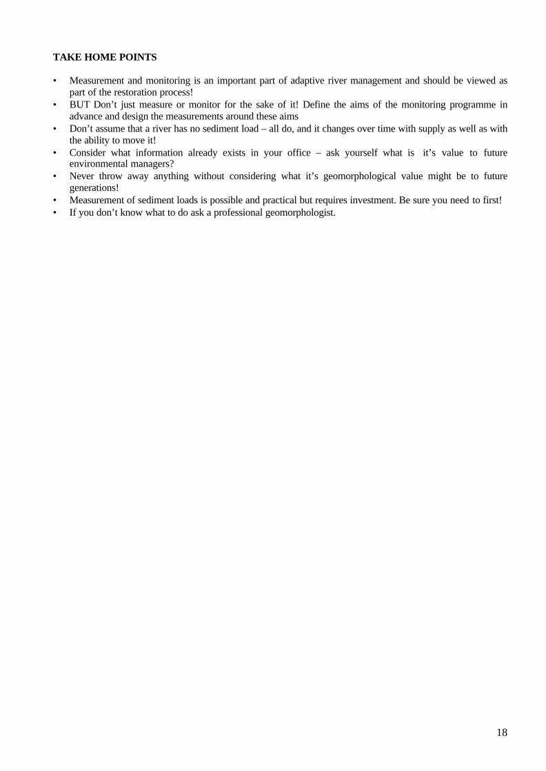
TAKE HOME POINTS
• Measurement and monitoring is an important part of adaptive river management and should be viewed aspart of the restoration process!
• BUT Don’t just measure or monitor for the sake of it! Define the aims of the monitoring programme inadvance and design the measurements around these aims
• Don’t assume that a river has no sediment load – all do, and it changes over time with supply as well as withthe ability to move it!
• Consider what information already exists in your office – ask yourself what is it’s value to futureenvironmental managers?
• Never throw away anything without considering what it’s geomorphological value might be to futuregenerations!
• Measurement of sediment loads is possible and practical but requires investment. Be sure you need to first!• If you don’t know what to do ask a professional geomorphologist.

19
Rehabilitation of riffles in rural watercourses
The ChallengeThe River Waveney has been identified as a candidate watercourse for coarse fish habitat rehabilitation usingriffles. The challenge lies in applying geomorphology to1) identify where in the main trunk stream, riffle rehabilitation can be sensibly undertaken2) how one might undertake the design and3) what form of post-project appraisal is necessary to produce the most effective and sustainable solution.
BackgroundThe River Waveney drains a catchment of 660km2, with an average slope of 1:2250, falling to 1:5500downstream of Billingham. Floodplain slopes are of the order of 1:2200. In contrast, tributary slopes are of theorder of 1:450 – 1:1100. Catchment geology is characterised by chalk overlain with boulder clay. Notableoutcrops of glacial sands and gravel’s occur in the upper catchment upstream of Bungay. Many of the uppertributaries cut through this fluvio-glacial material. Land use is principally arable with some mixed dairy andpiggery units. Free-range piggeries occupy the upper tributaries. The floodplains are grazing pasture, with SSSIstatus in 15 sites upstream of Bungay. The headwaters rise in Lopham and Redgrave Fen, SSSI. Channelmaintenance is undertaken on a 5 year rolling programme of de-silting, with an annual weed cut inAugust/September. The channel is heavily modified, being over-wide and over-deep, providing a 1:5 year floodprotection along the agricultural areas, rising to 1:75 year at Diss. Gravel riffles occur at or downstream ofbridges, and on tributary streams, where maintenance has not been undertaken. Throughout the river, mill weirsand sluices exist to support elevated water levels in summer and flood control in winter.
Constraints• A modified watercourse with few natural analogues in the catchment.• Low gradients along most of the river network heavily influenced by mill weirs.• Multiple land ownership.• Requirement from flood defence that rehabilitation does not compromise current levels of flood protection.• A catchment that is exporting significant quantities of fine sediment.• A finite and small budget (£40,000 including installation).
The Task is to specify the geomorphic principles you would follow to:
1. Identify the most appropriate sites for riffle rehabilitation2. Develop an appropriate design methodology for riffle rehabilitation.3. Develop a suitable post project appraisal system for the rehabilitated reaches
As One GroupTo help you achieve this, make a list of the key geomorphic variables that you might consider as necessary toacquire, and suggest possible sources for that information. What cost would you allocate from your budget?.
Workshop Group 1 and 2: Lowland Rural Watercourse –Restoring meanders and pools and rifflesCase Study: The River Waveney (Norfolk)
The Challenge

20
As Sub-groupsYou will be organised in to small groups to discuss one of the following aspects of the design although you shouldbe aware that they are not independent components!
• Catchment issues of significance for riffle rehabilitation (what’s important to know before we start? And howmight we acquire this information?)
• Riffle location – (where is suitable? How to define/identify suitable sites?)• Riffle morphology (How many? How far apart? how long?, how high? how steep? What substrate and from
where?)• Riffle hydraulics? (what impacts might they have on flood levels?)• Monitoring for project appraisal (What’s relevant? how often? how long for?)
Plenary session as One Group
Feedback from sub-groups to develop the whole project.Develop presentation for the workshop.
D.A.Sear/M.D.Newson 2001
Both Workshop leaders have considerable experience of applied geomorphology and river restoration. They run 1or 2-day training courses in geomorphology for river management and are available for consultancy. Contactinformation.
Dr David Sear
Dept. of Geography, University of Southampton, Highfield, SO17 1BJ, tel:02380592215, email [email protected]
Prof. Malcolm Newson
Dept. of Geograhy, University of Newcastle-upon-Tyne, Daysh Building, Claremont Road, Tyneside, NE41 7RU,tel:0191-222-6425, email [email protected]
River Waveney catchment and tributaries

21
Riffle Rehabilitation site: Planform
Long Profile of River Waveney

22
Riffle Rehabilitation site: Typical Cross-section
Riffle Rehabilitation site: Long Profile, bank and water surface elevations
0 200 400 600 800-2.5
-2.0
-1.5
-1.0
-0.5
0.0
0.5
1.0
1.5
Waveney Rehabilitation at Scole Pre-riffle installation: Q range 0.14 - 2.5 cumecs
Main Channel Distance (m)
Ele
vatio
n (m
)
Legend
WS Q=2.5 - Q=2.5
WS Q=1.104 - Q=1.104
WS Q=0.736 - Q=0.736
WS Q=0.266 - Q=0.266
WS Q=0.14 - Q=0.14
Ground
LOB
ROB
Scole
Pre-Rehabilitation
-2.5
-2
-1.5
-1
-0.5
0
0.5
0 5 10 15 20
Width (m)
Ele
vatio
n m
AD

23
The Waveney restoration scheme - what actually happened at Scole? To fulfil current performance criteria of sustainable design and a positive benefit-cost ratio, it is essential tohave a geomorphological assessment of rehabilitation proposals to define the following: • the features considered as typical of this type of river in this part of Britain;• the location of the segments/reaches suitable for works;• the potential threats posed by current sediment dynamics and channel/catchment management;• the design specification of the features selected;• the stability of the features once emplaced;• the influence of the features on physical habitat (flow types/biotopes). The non-tidal Waveney was given a Catchment Baseline Study, Fluvial Audit and Dynamics Assessment (seeprocedures used by EA derived from geomorphological R&D). The Catchment Baseline Study (CBS, Table 1)identifies more than 20 ‘lengths’ based on channel character in the field and heavily influenced by thebackwater conditions created by the many mill structures in the channel. The basic channel character of theWaveney is the result of the amount of available gradient (and therefore flow types/ morphological features),local sediment sources and riparian tree cover (which in turn controls instream macrophyte growth). The moreactive tributaries were, however, divided into reaches (in the more conventional geomorphological sense, basedon sediment sources and sinks).
As a result of the Waveney Catchment Baseline and Fluvial Audit the Anglian Region of the EnvironmentAgency decided to proceed with a Dynamic Assessment of four reaches deemed suitable for the rehabilitation of‘riffle’ features to improve a declining coarse fishery. These were at Diss, Scole, Shotford Bridge (Harleston)and Homersfield. The Dynamic Assessment was unusual in not addressing a problem of erosion or deposition,as such, but in establishing the appropriate dimensions, sedimentology and likely stability of artificially created‘riffles’ as habitat features for a coarse fishery (Table 2). The rehabilitation of pool-riffle sequences must start on the basis of an understanding of the ‘natural’ functions(hydraulic, sedimentological and ecological) of these features within the channel, followed by a decision onwhat functional service is to be the focus of their reinstatement. Specific geomorphological guidance onrehabilitating riffles can be gained from the research literature (Table 3) but most of the published studies ofpool-riffle sequences are derived from streams with gradients, stream power and sediments much larger thanthose experienced in East Anglian streams. This makes monitoring and post-project appraisal essential to bothmanagement and research in lowland rehabilitation.
Fortunately, riparian owners cooperated with the Environment Agency in selecting the reach immediatelydownstream of Scole for the installation of six rehabilitated gravel ‘riffles’ (Table 4), permitting an innovativeapproach to post-project appraisal in the hydraulic and geomorphological senses. Monitoring included surveysof benthic invertebrates and fish as well as morphology, sediments, water levels and flows.The chosen dimensions for the ‘riffles’ are given in Table 5 above. The gravel selected for the works was firstpiled on the river banks; size analysis shows the overwhelmingly unimodal distribution around 16mm (mainlyangular flint particles), compared with the 10mm calculated as the minimum stable sediment size fromstreampower (18.4W.m2 at bankfull) and shear stress calculations (9.8N.m2).
Rehabilitation work was carried out on the reach during a spell of dry anticyclonic weather in late April andearly May 1999; the total duration of work (including gravel carting from a roadside delivery point) was x days;a geomorphologist was on site during only three of these days in order to offer advice and carry out surveywork.
The impact of the ‘riffles’ (both singly and jointly) on upstream water levels was of prime interest to this studyand installation of twelve gauge boards two months in advance of the scheme allowed pre-’riffle’ water levels to
What actually happened

24
be recorded on seven separate occasions; surveys of both the gauge-board datums and adjacent cross sectionswere also made and tied into two stable temporary benchmarks.
The Waveney project has, in many ways, been a model of how to proceed. Geomorphological inputs have aidedin the selection of rehabilitation sites and in the design of the features. However, in such circumstances anyrelevant science is essentially 'learning' from participation and the monitoring scheme at Scole has provedinvaluable in refining our criteria for rehabilitation. Calibration of the 'HECRAS' hydraulic model using the datafrom the Scole gauge boards has indicated that, whilst the impact of the 'riffles' is negligible upon upstreamflood levels it is also relatively restricted on the distribution of physical biotopes in the river except at lowwinter flows (in summer the luxuriant growth of macrophytes tends to dominate the reach hydraulics).Nevertheless, the use of gravel 'riffle' mimics on the Waveney was principally to improve the spawningopportunity for Chubb and Dace, not to increase aeration or to promote particular patterns of erosion anddeposition around the new features. In this sense the Scole scheme is a successful compromise and in a sitewith slightly more flow energy the same restoration principles would have achieved even greater success. Table 1 Summary and conclusions of Waveney Catchment Baseline study GEOMORPHOLOGICAL CONSIDERATIONS• Sedimentation Low slope and structures produce ponded flow allowing siltation Increasing stream power to ‘self-cleansing’ levels impracticable Coordinated sluice operation and bed disruption might aid desilting Steeper tributaries generate and transport fines to main channel in high flows• Flow regime Recent low flows, abstraction and lack of effective floods a problem Flow augmentation is geomorphologically irrelevant in volume and timing Hard to predict effect of each control structure at all flows without a model• Channel maintenance Dredging in the past has removed much of the morphological diversity Current maintenance levels low, except in some tributaries Weed growth is part of the siltation problem; may be options for control REHABILITATION CONSIDERATIONS• Siltation Siltation might be ameliorated locally by ‘harder’ maintenance Alternatively, in certain sections, reduced weed removal may speed flow Siltation is a threat to rehabilitation features, especially in gravels, but proper design can aid self-cleansing• Flow regime Sediment transport rates will never be high in main channel - active forms such as natural barsand riffles may not be an option Flood frequency may be increased immediately upstream• Habitat change Full restoration would require a habitat model of pre-control or analogues All schemes must be matched with changing climate and land use

25
Table 2: Riffles and ‘riffle’ mimics, some distinctions Riffle (in active sediment system) Mimic for rehabilitation Sediment ‘queueing’ in active transport system(location normally stable)
Stable by design; coarser material and lowamplitude part of the stability
Induces unbroken standing waves at low tomoderate flows
May induce broken standing waves at lowflows - as part of an aeration function
Amplitude, spacing and mobility of sedimentsreduces impacts on flood flows
May have a calculable impact on upstreamflood levels as a result of effect on channelcapacity and roughness
Regular spacing 5-7 channel widths Channel wider at riffle - accommodates floods
Location often depends on access, riparian landmanagement and fisheries interests Width may not be enhanced
Table 3 Riffle morphology derived from the scientific literature. Variable Mean Range Slope 0.00541 m/m 0.00093 - 0.016 m/m Riffle spacing 172 m 17 - 1200 m Riffle length (L) 72 m 9 - 400 m Riffle length as % spacing 45% 17 - 76% Riffle amplitude (H) 0.6 m 0.24 - 2.00 m Riffle slope u/s of crest* 0.038 m/m 0.004 - 0.141 m/m Riffle slope d/s of crest 0.022 m/m 0.003 - 0.057 m/m Aspect ratio (L/H) 222 47 - 600 * crest is at 35% of riffle’s length
Table 4. ‘riffle’ designs for the River Waveney. All values are in meters unless specified. Site Reach
Length
‘riffle’Spacing
‘riffle’Length
No.‘riffles’ / reach
‘riffle’amplitude at crest
u/s lengthto crest
d/slengthfromcrest
Bed widthmax atcrest
Diss 275 65 29 7* 0.3 10 19 15%sectionaverage
Scole 475 45 20 6$ 0.3 7 13 15%sectionaverage
ShotfordBridge
257 122 55 3 0.25 - 0.4 20 35 15%sectionaverage
Homersfield
235 100 45 3 0.25 -0.4 16 29 15%sectionaverage
*for Diss this includes a number of point bars if further work is carried out in design $ actually 7, but one has been emplaced already (April, 1998)

26
Dr Helen Dangerfield, Babtie Group Ltd, Simpson House, 6 Cherry Orchard Road, Croydon, Surrey,CR9 6BE, Email: [email protected]
Part A The challengeThe project involves the restoration of a watercourse which runs through a historic urban park approximately 11acres in extent. The park lies alongside and to the east of the River Wandle in Colliers Wood, South London.The local Borough Council and the National Trust have joined to support works to improve the watercoursewhich is polluted, has a low flow problem and is geomorphologically, ecologically and aesthetically poor.
The Wandle Park river is currently a concrete lined channel fed from storm water which arrives via a pipedsewer outlet. The sewer runs along the left hand bank of the River Wandle and then underneath the bed of theRiver Wandle before it enters the park. The water from this outlet contains a high level of heavy metals andhydro-carbons and more importantly large quantities of silt (particularly in storm-water conditions). It is this siltin particular which prevents the existing channel from supporting vegetation or wildlife. During dry conditionsthe low gradient of the channel (0.00075) and low flows result in stagnant standing water.
The challenge is to identify the key geomorphological concepts which underpin this project. This should beaccompanied by a list of possible investigations and techniques which may be used. Following issues need to beaddressed (in small groups):
• Reducing channel siltation• Planform of the restored river• Channel morphology• Substrate and bed topography
This will enable the whole group to make a summary of the key criteria necessary to ensure successfulapplication of geomorphological principals at the design stage.
ConstraintsFlood standard must not be compromised – Wandle Park is an important element of the EA’s flooddefence strategy as it lies in the floodplain and can be expected to flood on a regular basis. Flooding occurs frombacking up of water at the downstream confluence of the Wandle Park Channel with the River Wandle.
Archaeology. The whole of the park lies within a designated ‘conservation area’ and English Heritage haveadvised that this park is of high archaeological value.
Ecology. Many of the trees within the park have an important landscape value and should not be disturbed.Trees follow the current planform of the channel in places.
Services. A high pressure gas main crosses from west to east under the park and a high voltage cable runsfrom north to south over the park with an associated underground cable. There are also a number of trunksewers which run under the park. Remains of an old swimming pool and air raid shelters are further constraintson construction.
Contaminated land. Preliminary feasibility studies have shown that there are pockets of contaminatedland within the park.
Workshop Group 3: Lowland Urban Watercourse – Enhancingan Urban WatercourseCase Study: The River Wandle (South London)
The Challenge

27
Plate 1 A view of the existing Wandle Park Channel illustrating the extensive siltation.

28
Figure 1 Map of the Wandle Park and Channel in 1894
Helen Dangerfield, Babtie Group (with permission from EA Thames Region)
29
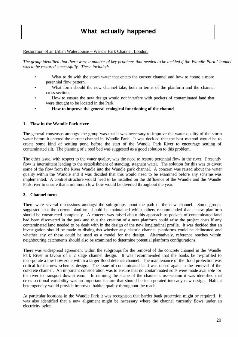
Restoration of an Urban Watercourse – Wandle Park Channel, London.
The group identified that there were a number of key problems that needed to be tackled if the Wandle Park Channelwas to be restored successfully. These included:
• What to do with the storm water that enters the current channel and how to create a moreperennial flow pattern.
• What form should the new channel take, both in terms of the planform and the channelcross-sections.
• How to ensure the new design would not interfere with pockets of contaminated land thatwere thought to be located in the Park
• How to improve the general ecological functioning of the channel
1. Flow in the Wandle Park river
The general consensus amongst the group was that it was necessary to improve the water quality of the stormwater before it entered the current channel in Wandle Park. It was decided that the best method would be tocreate some kind of settling pond before the start of the Wandle Park River to encourage settling ofcontaminated silt. The planting of a reed bed was suggested as a good solution to this problem.
The other issue, with respect to the water quality, was the need to restore perennial flow in the river. Presentlyflow is intermittent leading to the establishment of standing, stagnant water. The solution for this was to divertsome of the flow from the River Wandle into the Wandle park channel. A concern was raised about the waterquality within the Wandle and it was decided that this would need to be examined before any scheme wasimplemented. A control structure would need to be installed on the diffluence of the Wandle and the WandlePark river to ensure that a minimum low flow would be diverted throughout the year.
2. Channel form
There were several discussions amongst the sub-groups about the path of the new channel. Some groupssuggested that the current planform should be maintained whilst others recommended that a new planformshould be constructed completely. A concern was raised about this approach as pockets of contaminated landhad been discovered in the park and thus the creation of a new planform could raise the project costs if anycontaminated land needed to be dealt with in the design of the new longitudinal profile. It was decided that aninvestigation should be made to distinguish whether any historic channel planforms could be delineated andwhether any of these could be used as a model for the design. Alternatively, reference reaches withinneighbouring catchments should also be examined to determine potential planform configurations.
There was widespread agreement within the subgroups for the removal of the concrete channel in the WandlePark River in favour of a 2 stage channel design. It was recommended that the banks be re-profiled toincorporate a low flow zone within a larger flood defence channel. The maintenance of the flood protection wascritical for the new schemes design. The issue of contaminated land was raised again in the removal of theconcrete channel. An important consideration was to ensure that no contaminated soils were made available forthe river to transport downstream. In defining the shape of the channel cross-section it was identified thatcross-sectional variability was an important feature that should be incorporated into any new design. Habitatheterogeneity would provide improved habitat quality throughout the reach.
At particular locations in the Wandle Park it was recognised that harder bank protection might be required. Itwas also identified that a new alignment might be necessary where the channel currently flows under anelectricity pylon.
What actually happened

30
3. Contaminated land
The issue of contaminated land arose throughout the discussion on the new channel design. It wasrecommended that a full soil survey should be performed to determine the location of the pockets ofcontaminated land as a part of a preliminary baseline survey. This should be used to guide the designs anddetermine which of the options would be most suitable.
4. Ecological functioning of the river
It was identified that a key benefit in keeping the current channel planform configuration was the maturevegetation that existed in the riparian corridor. Riparian cover should be maintained in the design of the newchannel. It was also suggested that valuable habitat could be created by importing gravels into new riffle zones.This could provide new spawning habitat.
The restoration design, completed 1999.
The rectangular concrete channel was removed and replaced with a variable width, two-stage channel. Thebankfull channel capacity was designed to the same flood protection, with the meandering low flow channel freeto adjust its planform within the bankfull channel. Low flows were maintained through the channel byabstracting 0.15 cumecs from the main River Wandle. This discharge was designed to increase to a maximumvalue of 0.5 cumecs when the flows in the main Wandle reach a maximum of 11.72 cumecs (Tr = 2 years).Flows are controlled by an offtake structure at the upstream end of the park which then enters into a newlyconstructed two-stage channel which links up with the existing channel. The original planform of the channelwas maintained, largely because there was no significant alteration from the 1847 watercourse when the riverwas first concreted. In addition, it was important to preserve as many of mature trees which line the channel aspossible throughout the park. However, the channel was diverted away from the pylon at the downstream end ofthe park.
The scope for the natural development of pool-riffle sequences was limited by low channel gradient and lowaverage velocities. Local diversity of the bed configuration was therefore introduced during construction, whichhas resulted in some adjustment during higher flow events. The capacity of the channel to convey suspendedsediment was also limited resulting in a siltation problem. Sampling of the sediment indicated that it containselevated levels of PAH’s and heavy metals. The storm water outflow was therefore removed from the mainchannel and diverted into a settling pond and reed bed before flowing back into the Wandle Park Channeldownstream. The reed bed was sized and configured to achieve a compromise between water qualityimprovement, landtake, preservation of trees and cost constraints.
Mixed gravels obtained were reinstated to the new channel downstream of the offtake structure. Gravels arisingfrom excavation from remnant fluvial deposits were used after they were verified as river deposits supplementedby gravels of a similar grade, based on remnant deposits and the sediment survey of rivers in Thames Region.
Dr. Kevin Skinner, University of NottinghamDr. Helen Dangerfield, 1b

31
Dr David Gilvear, Department of Environmental Science, University of Stirling, FK9 4LA,Tel: 01786 467845, Email: [email protected]
PART A The challenge
Assume you have been asked to design an ecologically sound river diversion on the River Nith because theexisting natural river lies in an area of valley floor that is to be mined. The river has a flashy river regime andhas a coarse gravel bed. The length of river to be diverted is approximately 3 kilometres, channel width 8-10metres (See Figure 1;Plate 1).and here the Nith cross a large expanse of relatively low gradient (slope 0.006)valley floor.
Figure 1 – The proposed alignment of the river diversion, together with the location of the existing reach of theRiver Nith and its tributaries
The major constraint is that you are restricted to a narrow river corridor running along the northern edge of thefloodplain and that floods have to be contained within the corridor by flood embankments at the edge of thecorridor. The task is to specify the geomorphic principles you would follow to produce an appropriate design,make a list of the key geomorphic criteria that would result in a river channel morphology based on soundgeomorphic criteria and investigations you might undertake to provide the information required.
Workshop Group 4: Upland Rural Watercourse – Creation ofan Environmentally Acceptable ChannelCase Study: The River Nith (Dumfries and Galloway)
The Challenge

32
You will be organised in to groups to discuss one of the following aspects of the design although you should beaware that they are not independent variables
Channel slopeChannel planform and sinuosityChannel morphologyChannel substrate
Plate 1 A typical view of the existing river Nith

33
Figure 2 A detailed view of the River corridor within which you can build your river diversion. The mineworking area will create an excavation of 40 metres plus depth
02/04/01DJ Gilvear (with permission of Halcrow Crouch)

34
Building a river diversion – The River Nith, House of water
Outcomes of the delegated discussions with regard to the task of building a river diversion on an uplandriver system
The challenge was for workshop participants to providing some geomorphologically sound guiding principlesfor the design an ecologically sound river diversion on the River Nith in South West Scotland. The requirementfor the diversion was due to the need to move the natural channel to make way for coal mining operations(Figure 1). The participants worked in sub groups on the following aspects of channel design: Channel slope,Channel planform and sinuosity, channel cross-sectional morphology and channel substrate. It was realised thatthese morphological aspects of channel design were interrelated.
Figure 1 - The site layout with the planform of the diversion corridor indicated.
5. Channel slope
The general consensus amongst the group was that it was necessary to try and maintain the channel slope similarto that of the existing channel. This was because otherwise stream power would be altered and aggradation anddegradation problems could arise due to an altered sediment transport capacity. It was realised that there weretwo difficulties with fulfilling this wish. Firstly within the constraints of the river corridor available for routingthe channel, the length of diversion would have to be a little shorter than the existing channel. The secondproblem that was identified by one of the group members was that incoming tributaries would meet have theirconfluence with the new channel at a different elevation than that of their previous confluence. It was suggestedthat steps might need to be taken to prevent morphological change at these confluence areas.6. Channel planform and sinuosity
There were several discussions amongst the sub-groups about the path of the new channel. Some groupssuggested that the basic planform of the existing channel should be used as a template and that even a “mirror-
What actually happened

35
image” could be used. Scrutiny of problem showed that such an appealing approach would not be feasible giventhe river corridor width available. It was decided that the course should approximate the existing channel bymaintaining similar meander forms and sinuosity. At particular locations it was recognised that harder bankprotection might be required to safeguard the embankment preventing floodwaters entering the mine site.Backfilling trenches away from the river channel to act as “backstops” was suggested.
7. Channel morphology
The consensus was simple that the diversion should be built with a channel cross-section that had the samewidth and depth dimensions as the existing channel. Some mention was made as to whether there was need toconstruct in-channel features but their was little consensus on the matter. The linkage between channelplanform and cross-sectional morphology was highlighted but the effect of slope variability along the channelon morphology was noy discussed.
8. Channel substrate
It was identified that dewatering of the channel was a potential problem due to the adjacent mine and that a linerof some description would be required. The need to create a channel substarte with the same particle sizecharacteristics was also appreciated. Their was some discussion of whether there was the need for pool and rifflecreation given the high stream powers and potential for widespread sediment movement. The problem of pool-riffle spacing and dovetailing this with the channel planform was also raised.
The diversion design (September 2000) and geomorphological performance,
The workshop participants were informed that a 2.7km river diversion was built with a channel morphology thatmaintained the main planform and substrate features of the existing channel but was not a mirror image. Thechannel incorporated pools and riffles and a natural bed with a substrate particle size range similar to that of theexisting channel. Outer riverbanks in critical locations were rip-rapped with “degradable” sandstone. Thediversion design was primarily the work of Halcrow Crouch with the construction being undertaken by BachySoletanche.
It was indicated to the delegates that subsequent scutiny of the long profile showed that there were two adjacentreaches that maintained a slope which were respectively of higher and lower gradient than the previouslyexisting natural channel gradient. This in part was due to the terrain over which the new course had to be built.Another feature pointed out was the fact that the tributaries had by necessity their lower courses truncated andtheir stream bed elevation did not necessarily match that of the diversion bed level.
The robustness of the river diversion was tested fully in the autumn of 2000 as a result of the occurrence of twolarge flood events (estimated return periods exceeding 1 in 10 years) in close succession. The river diversionsurvived the floods pretty much intact with bank erosion being localised. The area of greatest geomorphologicalchange occurred in the area where there was localised deviation of the channel slope away from that of thenatural river that once existed. Bedload movement occurred in the steeper upstream section and this materialwas deposited in the low gradient reach downstream in effect infilling the channel and creating a new bed levelclose to the general valley floor elevation (Figure 2a). It demonstrates the sensitivity of upland stream system toriver diversion and restoration design and the need to maintain the sediment transport capacity of engineeredreaches at a level that will convey the natural sediment load. The same flood also created a variety of point barand mid-channel bar features and sorted the river bed sediments enhancing the morphological diversity of thechannel (Figure 2b). Tributary junctions were also an area of morphological change with a ‘knick point’ andupstream bed degradation (now halted by rock placements) occurring on one of the tributaries. Overall thesuccess of the diversion was illustrated but the occurrence of the large floods demonstrated that if there isinadequate attention given with regard to geomorphological processes and design criteria, problems can rapidlyoccur in high energy upland channel. It also demonstrates that river restoration on upland channel need notworry unduly about meso-scale geomorphological features because the first major flood will “construct” suchfeatures as point and mid-channel bars.

36
A)
B)
Figure 2 (A) A depositional reach on the new diversion showing the bed level approximating that of the valleyfloor (B) Creation of point and lateral gravel bars on the river diversion following the autumn floods