River Basin Management Planning in Indonesia: Policy and Practice
287
RIVER BASIN MANAGEMENT PLANNING IN INDONESIA POLICY AND PRACTICE ASIAN DEVELOPMENT BANK
Transcript of River Basin Management Planning in Indonesia: Policy and Practice
RIVER BASIN MANAGEMENTPLANNING IN INDONESIAPOLICY AND PRACTICE
RIVER BASIN
MA
NAG
EMEN
T PLAN
NIN
G IN
IND
ON
ESIA: PO
LICY AN
D PRACTICE
River Basin Management Planning in IndonesiaPolicy and Practice
This report summarizes the strengths, challenges, opportunities, and risks characterizing the prospects for integrated water resources management in Indonesia. Integrated water resources management planning is essential for sustainable growth. Indonesia’s rapid economic growth, increas ing populations, and trends in developing and urbanizing environments are leading to potential confl icts as more users claim the same water resources. Understanding these conditions may provide decision makers with more insight to optimize the country’s water resources potential using available and state-of-the-art methodologies and tools for river basin planning. The report discusses all aspects of basin planning based on experiences from one of Indonesia’s most complex and strategic river basins.
About the Asian Development Bank
ADB’s vision is an Asia and Pacifi c region free of poverty. Its mission is to help its developing member countries reduce poverty and improve the quality of life of their people. Despite the region’s many successes, it remains home to the majority of the world’s poor. ADB is committed to reducing poverty through inclusive economic growth, environmentally sustainable growth, and regional integration.
Based in Manila, ADB is owned by 67 members, including 48 from the region. Its main instruments for helping its developing member countries are policy dialogue, loans, equity investments, guarantees, grants, and technical assistance.
ISBN 978-92-9257-387-4
ASIAN DEVELOPMENT BANK
ASIAN DEVELOPMENT BANK6 ADB Avenue, Mandaluyong City1550 Metro Manila, Philippineswww.adb.org
BKK157181 SERD River Basin Management Planning-COVER_31May2016.indd 1 6/9/2016 6:17:45 PM
ASIAN DEVELOPMENT BANK
Creative Commons Attribution 3.0 IGO license (CC BY 3.0 IGO)
© 2016 Asian Development Bank6 ADB Avenue, Mandaluyong City, 1550 Metro Manila, PhilippinesTel +63 2 632 4444; Fax +63 2 636 2444www.adb.org
Some rights reserved. Published in 2016. Printed in the Philippines.
ISBN 978-92-9257-387-4 (Print), 978-92-9257-388-1 (e-ISBN)Publication Stock No. BKK157181
Cataloging-In-Publication Data
Asian Development Bank. River basin management planning in Indonesia: Policy and practice.Mandaluyong City, Philippines: Asian Development Bank, 2016.
1. River basin management planning. 2. Indonesian policy and practice. I. Asian Development Bank.
The views expressed in this publication are those of the authors and do not necessarily reflect the views and policies of the Asian Development Bank (ADB) or its Board of Governors or the governments they represent.
ADB does not guarantee the accuracy of the data included in this publication and accepts no responsibility for any consequence of their use. The mention of specific companies or products of manufacturers does not imply that they are endorsed or recommended by ADB in preference to others of a similar nature that are not mentioned.
By making any designation of or reference to a particular territory or geographic area, or by using the term “country” in this document, ADB does not intend to make any judgments as to the legal or other status of any territory or area.
This work is available under the Creative Commons Attribution 3.0 IGO license (CC BY 3.0 IGO) https://creativecommons.org/licenses/by/3.0/igo/. By using the content of this publication, you agree to be bound by the terms of this license.
This CC license does not apply to non-ADB copyright materials in this publication. If the material is attributed to another source, please contact the copyright owner or publisher of that source for permission to reproduce it. ADB cannot be held liable for any claims that arise as a result of your use of the material.
Attribution—In acknowledging ADB as the source, please be sure to include all of the following information: Author. Year of publication. Title of the material. © Asian Development Bank [and/or Publisher].
URL. Available under a CC BY 3.0 IGO license.
Translations—Any translations you create should carry the following disclaimer:Originally published by the Asian Development Bank in English under the title [title] © [Year of publication]
Asian Development Bank. All rights reserved. The quality of this translation and its coherence with the original text is the sole responsibility of the [translator]. The English original of this work is the only official version.
Adaptations—Any adaptations you create should carry the following disclaimer:This is an adaptation of an original Work © Asian Development Bank [Year]. The views expressed here are
those of the authors and do not necessarily reflect the views and policies of ADB or its Board of Governors or the governments they represent. ADB does not endorse this work or guarantee the accuracy of the data included in this publication and accepts no responsibility for any consequence of their use.
Please contact [email protected] if you have questions or comments with respect to content, or if you wish to obtain copyright permission for your intended use that does not fall within these terms, or for permission to use the ADB logo.
Notes: In this publication, “$” refers to US dollars. Corrigenda to ADB publications may be found at: http://www.adb.org/publications/corrigenda Cover photo was provided by Deni Sambas (www.citarum.org).
Contents
Tables, Figures, Boxes, and Maps viiiAcknowledgments xiiiAbbreviations xivExecutive Summary xviii
Strengths xixChallenges xxOpportunities xxiiRisks xxvRecommendations xxv
1 Introduction 12 Global and Indonesian Principles of Integrated Water Resources
Management and Basin Water Resources Management Planning 72.1. Global Objectives 72.2. Global Key Principles and Concepts of Integrated Water
Resources Management 82.3. Global Experience with Integrated Water Resources
Management and Future Developments 122.4. Integrated Water Resources Management Application
and Basin Planning in Indonesia 152.4.1. Integrated Water Resources Management
Application in Indonesia 152.4.2. Basin Water Resources Management Planning
in Indonesia 182.4.3. Principles for Integration of Basin and Spatial Planning 222.4.4. Progress in Basin Planning in Indonesia 262.4.5. Progress in Formation of Water Resources Councils 27
3 Legal and Institutional Framework in Indonesia 293.1. Introduction 293.2. Legal Framework 30
3.2.1. Introduction 303.2.2. Main Characteristics of the Law on Water Resources 32

3.2.3. Authority and Responsibility 353.2.4. Legal Instruments 37
3.3. Institutional Framework 433.3.1. Designated River Basin Management Organizations 433.3.2. Performance of River Basin Organizations 453.3.3. Organization of Stakeholder Involvement 463.3.4. Coordination through Plan Formulation 48
3.4. Assessment of Existing Capacity 533.4.1. Capacity for Water Resources Management 533.4.2. Capacity for Basin Water Resources
Management Planning 543.5. Financial Arrangements 54
3.5.1. Financing Water Resources Management 543.5.2. Water Resources Management Budget Allocation 57
4 Basin Planning Required in Indonesia 614.1. Introduction 614.2. Pola 64
4.2.1. Introduction 644.2.2. Phase 1: Preparation 674.2.3. Phase 2: Formulation 724.2.4. Phase 3: Finalization and Legalization 93
4.3. Rencana 934.3.1. Overview 934.3.2. Phase 1: Inventory 964.3.3. Phase 2: Formulation of the Rencana 1004.3.4. Phase 3: Finalization and Legalization 101
4.4. Experience with Basin Planning in Indonesia 1014.4.1. Position of the Pola and Rencana in Relation
to Other Governmental Activities 1024.4.2. The Pola as a Strategic Document 1024.4.3. Guidelines for Plan Preparation (Analysis Process) 1034.4.4. Planning Methods, Models, and Data 1034.4.5. Planning Capacity 104
iv Contents
4.5. Citarum River Basin Road Map 1044.5.1. Legal Basis 1044.5.2. Methodology 1054.5.3. Comparison of the Pola and Rencana
with Road Map Approach 106
5 Methodology of Basin Planning in Indonesia 1095.1. Introduction 1095.2. Methodology 109
5.2.1. Conservation 1095.2.2. Water Utilization 1155.2.3. Disaster Management 1175.2.4. Data and Information 1185.2.5. Community Participation and Institutional Aspects 118
5.3. Integration 1205.3.1. Island-Wide Approach 1205.3.2. Water Resources Management
and Spatial Planning for Food Security 1255.3.3. Water Resources Management and Spatial Planning for
Conservation, Water Utilization, and Flood Management 1275.3.4. Integrated Flood Management and Spatial Planning 1335.3.5. Utilization and Damage Control from Land Subsidence 135
5.4. Tools 1365.4.1. Importance of Tools 1365.4.2. Hydrological Databases 1375.4.3. River Basin Planning Decision Support System 1385.4.4. Flood Management Analysis Tools 1395.4.5. Simulation of Spatial Development 1425.4.6. Elaboration of Zoning 1465.4.7. Spatial Management for Control of Internal Drainage 1495.4.8. Spatial Management for Control of External Drainage 1505.4.9. Spatial Management for Catchment Conservation 1535.4.10. Evaluation of Priorities (Pola) and
Cost and Benefits (Rencana) 1575.4.11. State of the Basin Reporting 165
5.5. Water Quality: Management, Cost, and Benefits 169
Contents v
5.5.1. Overall Approach 1695.5.2. Determination of Water Quality in Upper Citarum River 1695.5.3. Determination of Discharge of Pollution
(Loads and Flows) 1695.5.4. Determination of Intervention to Reduce Pollution 1715.5.5. Water Quality Modeling and Scenarios 1745.5.6. Benefit Estimation 1765.5.7. Conclusion 178
5.6. Forecasting 1795.6.1. Scenarios (Including Climate Change Scenarios) 1795.6.2. Strategies 1845.6.3. Consistencies (Java Spatial Model) 185
6 Experience in River Basin Planning in Indonesia 1866.1. Introduction 1866.2. Achievements in Various Basins 187
6.2.1. Brantas Basin 1876.2.2. Bengawan Solo Basin 1886.2.3. West Java and Citarum Basin 1886.2.4. Central Java and Jratunseluna Basin 1906.2.5. Progo Opak Serang Basin 1916.2.6. Pemali Comal 192
6.3. Experience in Coordination with the Tim Koordinasi Pengelolaan Sumber Daya Air 193
6.3.1. Establishing Water Councils 1936.3.2. Experience with the Tim Koordinasi Pengelolaan
Sumber Daya Air in 6 Cis 1946.4. Perceptions of Ongoing Basin Planning in Indonesia 198
6.4.1. Introduction 1986.4.2. Aim of Basin Planning 1996.4.3. Results of Basin Planning So Far 1996.4.4. Could the Result Have Been Better? 2036.4.5. How to Improve Basin Planning 205
6.5. Capacity Development 207
vi Contents
7. Suggestions for the Way Forward 2107.1. Introduction 2107.2. Legal Framework 210
7.2.1. Challenges in Legal Framework 2107.2.2. Recommendations for Legal Framework 212
7.3. Institutional Framework and Capacity Building 2137.3.1. Challenges in Institutional Framework 2137.3.2. Challenges in Capacity 2187.3.3. Recommendations on Institutional
Aspects and Capacity Building 2187.4. Planning Process 220
7.4.1. Challenges in the Planning Process 2207.4.2. Recommendations Concerning the Planning Process 223
7.5. Enhancing Implementation of the Pola and Rencana 2277.5.1. Challenges in Intersector Approach 2277.5.2. Position of the Pola and Rencana in Relation
to Other Governmental Activities 2287.5.3. Recommendations Concerning Enhanced Adherence
and Application of the Pola and Rencana 229
Index 230
Contents vii

Tables, Figures, Boxes, and Maps
Tables
2.1: National Priorities 2010–2014 (PerPres No. 5/2010) 16
2.2: Overview of Progress in Formulation of Pola and Rencana (Status May 2014) 26
2.3: Overview of Progress in Establishment of Water Councils 28
3.1: The Indonesian Legal System 30
3.2: Government Regulations Related to Law 7/2004 34
3.3: Similarities between Planning for Water Resources and Spatial Management 39
3.4: Overview of River Basin Organizations in Indonesia 44
3.5: Overview of River Basin Organizations in Java (situation November 2012) 44
4.1: Suggested Participants for Public Consultation Meeting (from PerMen PU 22/2009) 71
4.2: Overview of Aspects to Be Analyzed 73
4.3: Matrix of Operational Policies 81
4.4: Concept Matrix for Proposed Measures 98
4.5: Overview of Measures and Impact on Various Aspects 107
5.1: Overview of Estimates for Domestic Water Demand (PU 1999) 116
5.2: Themes and Indicators 120
5.3: Overview of the Indicator Values and Scores for “Too Much Water” (2010) 122
5.4: Potential Retention Capacity in Jakarta 150
5.5: Estimated Impact of Saguling Losing All of Its Storage 155
5.6: Overview of Measures and Cost for Watershed Conservation Measures 156
5.7: Summary Overview of Java Water Resources Strategic Study Cost-Estimating Relationships (1991 Price Level) 160

5.8: Operational Costs for Drinking Water Treatment Plants in the 6 Cis Project (2010 Price Level) 162
5.9: Agroeconomic Analysis 164
5.10: Economic Benefits for Various Types of Measures 166
5.11: Key Performance Areas, Indices, and Subindicators of Basin Status Benchmarking 167
5.12: Proposed Framework for Physical River Basin Performance Benchmarking 168
5.13: Overview and Features of Applicable Sanitation Options in the Indonesian Context 171
5.14: Assumed Removal Efficiencies in Water Treatment Systems 172
5.15: Effluent Requirement and (Current) Applicable Water Quality Standards for Biological Oxygen Demand and Chemical Oxygen Demand 175
5.16: Benefits of Improved Sanitation and Wastewater Management 176
5.17: Parameters of Data Sources to Estimate Reuse Values in Scenario 6 177
5.18: Overview of Benefits/Cost for Waste Water Treatment in Upper Citarum Basin 178
6.1: Overview of Establishment of Dewan Sumber Daya Air 195
6.2: Overview of Progress in Establishment of Water Councils 196
6.3: Available Basin Water Resources Planning Modules/Pedoman 209
Figures
1.1: Evolution in Techniques: From Development of Infrastructure to Demand Management 3
2.1: General Framework of Integrated Water Resources Management 10
2.2: Integrated Water Resources Management—Involving All Stakeholders 11
2.3: Integrated Water Resources Management as a Process of Adaptive Management, with a Spiral of Progress (left), Illustrated by the Development in Planning of the Brantas River in Indonesia (right) 13
2.4: Policy Analysis Approach to Basin Planning in 6 Cis River Basin Territory 19
2.5: Position of Basin Plan Related to Other Strategic Plans 21
Tables, Figures, Boxes, and Maps ix
2.6: Integrated Spatial Planning and Water Resources Planning 23
2.7: Water Zoning in Spatial Planning 24
3.1: Water Resources Management Policy and Plan Formulation in Indonesia 37
3.2: Provincial Basin: Policy Formulation and Planning 49
3.3: Interprovincial Basin: Policy Formulation and Planning 51
3.4: National Strategic Basin: Policy Formulation and Planning 52
3.1: Flow Diagram on Musrenbang Process 58
4.1: Topics to Address in Planning 63
4.2: Process for Pola Formulation 66
4.3: Approval Process for Pola for Five Different Situations 94
4.4: Process for Rencana Formulation 95
5.1: Rencana PSDA WS Citarum Showing Critical Watershed Addressed in Three Stages 111
5.2: Upper WS Citarum Kawasan Lindung and Less Forest 112
5.3: Water Quality in Citarum River 114
5.4: Water Balance in the Citarum Basin 117
5.5: Analytical Units Showing Hotspots “Too Much” (Units Most Affected by Floods) 121
5.6: Overview of Hotspots for Water Utilization and Potential Inter-WS Transfers 125
5.7: Rice Production and Consumption Trend in Java 127
5.8: Relations between Water Resources Planning and Spatial Planning 128
5.9: Planned Land-Use Map: Green Is Protected, the Rest May or Will Be Converted to Urban Area 129
5.10: Structuring and Quantifying Space–Water Relationships 131
5.11: Water Zoning in Spatial Planning 132
5.12: Implementation of Spatial Management through the Spatial Plan 133
5.13: Overview of Zoning for Flood Management 134
x Tables, Figures, Boxes, and Maps
5.14: Sketch of Land Subsidence in Jakarta (1989, 2007, and 2025) 136
5.14a: River Network Applied in the Hydrodynamic Model for the Greater Jakarta Area 141
5.14b: Hydrodynamic Model for Jakarta Area 142
5.15: Overview of the Java Spatial Model 143
5.16: Growth of Urban Area 145
5.17: Assessment of Water Management Problem—Example Upper Citarum Structuring 147
5.18: Flooding Due to Urbanization 151
5.19: Assessment of Sensitivity for Contribution to Floods and Impact on Zoning 151
5.20: Translating Located Vulnerable Zone to Indication of Specific Zone in Spatial Plan 152
5.21: Comparison of Hydrographs for Upper Ciliwung Catchment (Katulampa) for Different Land Uses 152
5.22: Schematic Outline of the Erosion Model 154
5.23: Estimated Sedimentation Rate for Saguling Reservoir 155
5.24: Zoning for Agricultural Protection (light green) and Expanded Conservation Zone (dark green) 157
5.25: Pollutant Discharge per Water District for Domestic, Municipal, Industrial, and Agricultural Activities 170
5.26: Decision Model on Feasibility of Type of Wastewater Treatment System 172
5.27: Typical Price of Wastewater Treatment System per Person Served per Urban and Rural Condition and Density 173
5.28: Developed River Basin Simulation Model and Locations Simulated 175
5.29: Projected and Actual Census Population Numbers, 2000–2025 181
5.30: Projected Population Growth Rates 182
5.31: Historic and Projected Economic Growth Rates 183
7.1: Criteria for Screening Process 225
Tables, Figures, Boxes, and Maps xi

xii Tables, Figures, Boxes, and Maps
Boxes
2.1: Dublin Principles on Integrated Water Resources Management 8
2.2: Integration of Spatial Planning and Water Resources Planning 23
3.1: Effective Water Resources Management in Indonesia 46
4.1: Data Collection 68
4.2: Topics to Be Addressed in Draft Pola 70
4.3: Scenarios 77
4.4: Main Strategies and Specific Strategies 77
4.5: Topics for Discussion in Step 2.5 79
4.6: Road Map Approach 108
6.1: Factors Concerning Water Resources Management Cooperation between Sectors in Indonesia 201
Maps
5.1: Rencana PSDA WS Citarum Showing Critical Watershed Addressed in Three Stages 111
5.2: Upper WS Citarum Kawasan Lindung and Less Forest 112
5.5: Analytical Units Showing Hot Spots “Too Much” (Units Most Affected by Floods) 121
5.6: Overview of Hot Spots for Water Utilization and Potential Inter-WS Transfers 125
5.9: Planned Land-Use Map: Green Is Protected, the Rest May or Will Be Converted to Urban Area 129
5.14a: River Network Applied in the Hydrodynamic Model for the Greater Jakarta Area 141
5.14b: Hydrodynamic Model for Jakarta Area 142
5.16: Growth of Urban Area 145
5.24: Zoning for Agricultural Protection (light green) and Expanded Conservation Zone (dark green) 157

Acknowledgments
This publication is based on the technical assistance (TA) project of the Asian Development Bank (ADB) that was implemented by the Ministry of Public Works, Directorate General of Water Resources in Indonesia.
The TA project was financed by the Government of the Netherlands, the Multi-Donor Trust Fund under the Water Financing Partnership Facility, and ADB’s Technical Assistance Special Fund under the project TA 7189-INO: Institutional Strengthening for Integrated Water Resources Management in the 6 Cis River Basin Territory (Package B). The publication describes the experience of the river basin planning process in Indonesia, including the formulation of the basin plans (Pola and Rencana). It comprises both the ideal conditions of a river basin plan and the actual steps and processes needed for analysis, formulation, and implementation of the plans. The publication is intended to disseminate the TA output and lessons learned for water resources practitioners in Indonesia and in the region. We thank the people mentioned below for their contributions to this publication.
The main contributor and editor is Aart van Nes.
Contributors for the various chapters in the publication are Eelco van Beek, Jos Dijkman, Hendarti, Bart Teeuwen (legal aspects), Rudolf van Ommen (institutional aspects), Poul Grashoff and Robert Verhaeghe (methodologies and tools), Sjoerd Kerstens (water quality), and Jan Jaap Brinkman (flood management).
Peer reviewers are Roestam Sjarief and Mochammad Amron (Former Director General of Water Resources, Ministry of Public Works), Tadasinghe Kawasaki (Network of Asian River Basin Organizations), Wouter Lincklaen Arriens (Water Resources Expert and Former Lead Water Resources Specialist, ADB), Eric Quincieu, and Helena Lawira (ADB). James Hutchins provided editing services.
Other contributors are M. Donny Azdan (Director of Water and Irrigation, National Planning Development Agency [BAPPENAS]); Arie Setiadi Moerwanto (Director of Water Resources Management, Ministry of Public Works); Imam Anshori, Budhi Santoso, and Ni Made Sumiarsih (Directorate of Water Resources Management, Ministry of Public Works); Yunita Chandra (Ministry of Public Works); Iwan Kurniawan (Ministry of Home Affairs); and Nidhom Ashari, Nico Darismanto, and Willem van Diest (independent consultants).
Photo Credits: Diella Dachlan, Deden Iman, Deni Sambas, and Ng Swan Ti.
6 Cis – The six rivers project (TA 7189) (2009–2013)ADB – Asian Development BankAWP – annual work planBalai PSDA – Balai Pengelolaan Sumber Daya Air (water resources
management center at the provincial level)BAPPEDA – Badan Perencanaan Pembangunan Daerah
(Regional Development Planning Agency)BAPPENAS – Badan Perencanaan dan Pembangunan Nasional
(National Development Planning Agency)B(B)WS – Balai (Besar) Wilayah Sungai (Greater Basin Territory
Center, Ministry of Public Works level)BLU – Badan Layanan Umum (Public service organization
that can collect charges)BMKG – Badan Meteorologi, Klimatologi dan Geofisika (Indonesian
Institute for Meteorology, Climatology, and Geophysics)BOD – biological oxygen demandBPS – Badan Pusat Statistik (Central Statistics Agency of
Indonesia)BTA 155 – Cisadane-Cimanuk Integrated WRD project, first Pola and
Rencana (1985–1991)BWRMP – Basin Water Resources Management Planning; Revised
project component for formulation of River Basin Water Management Master Plans in Indonesia (2001–2004)
BWRP – Basin Water Resources Planning (1996–2001, later changed to BWRMP)
CDAP – capacity development action planCER – cost estimating relationshipCOD – chemical oxygen demandDAS – Daerah Aliran Sungai or river basin/watershedDEM – Digital Elevation ModeDGWR – Directorate General for Water Resources at Ministry
of Public Works Dinas SDA – Provincial or District Water Resources Service
(PU Pengairan)DIPA – Daftar Isian Pelaksanaan Anggaran (budget
implementation guidance) (annual budget allocation)
Abbreviations
Abbreviations xv
DMI – domestic, municipal, and industrial (water demand)DSS – Decision Support System, such as River Basin SimulationFGD – focus group discussionGIS – geographic information systemICWRMIP – Integrated Citarum Water Resources Management
Investment ProgramIWRM – Integrated Water Resources ManagementJABO(DE)TABEK
– Area comprising Jakarta, Bogor, (Depok), Tangerang, and Bekasi
JIWMP – Java Irrigation and Water Management ProjectJSM – Java Spatial ModelJWRMS – Jabotabek Water Resources Management Study
(1991–1995)JWRSS – Java Water Resources Strategic Study (2010–2012)Kabupaten/Kota
– District/City, autonomous administrative level within the province
KepMen – Ministerial DecreeKepPres – Presidential DecreeM&E – monitoring and evaluationMDG – Millennium Development GoalMFF – multitranche financing facility (for ADB loans)MPW – Ministry of Public WorksNARBO – Network of Asian River Basin OrganizationsNGO – nongovernment organizationO&M – operation and maintenancePCM (PKM) – public consultation meetingPerda – Regulation approved by the regional council at the
provincial, district, or city levelPerMen – Regulation issued by the ministerPerPres – Regulation issued by the PresidentPJT – Perum Jasa Tirta (National Corporation for Basin
Management, PJT 1 for Brantas and other basins, PJT 2 for Citarum basin)
Pola – Framework for strategic management plans (will be followed by Rencana)
PP – Peraturan Pemerintah (Government Regulation)
xvi Abbreviations
PusAir – Agency for Research and Development in Water Resources, under MPW
PSDA – Pengelolaan Sumber Daya AirPWRS – Provincial Water Resources ServicesRBO – river basin organizationRBMO – river basin management organizationRBT – river basin territory (Wilayah Sungai, WS)RCMU – Road Map Coordination Management UnitRencana – Master plan for river basin management
(follow-up of Pola)RIBASIM – River Basin Simulation Model, decision support system
for water resources planning/managementRPJMN or RPJMD
– Rencana Pembangunan Jangka Menengah Nasional (National Medium-Term Development Plan), development plans for national (N) or regional (D) governments (5 years)
RPJPN or RPJPD
– Rencana Pembangunan Jangka Panjang Nasional (National Long-Term Development Plan), long-term development plans (20 years)
RTRW – Rencana Tata Ruang Wilayah (spatial plan)Sawah – rice fieldSDA – Sumber Daya Air (water resources)SIH3 – Sistem Informasi Hidrologi, Hidrometeorologi dan
Hidrogeologi pada tingkat Nasional (National information system for hydrology, hydrometeorology and hydrogeology)
SRES – Special Report on Emission ScenariosSWS – Satuan Wilayah Sungai (river basin unit)TA – technical assistanceTKPSDA – Tim Koordinasi Pengelolaan Sumber Daya Air
(Basin Water Resources Management Council) UNESCO – United Nations Educational, Scientific and Cultural
OrganizationUSLE – universal soil loss equationWISMP – Water Resources and Irrigation Sector Management ProgramWRM – water resources managementWS – Wilayah Sungai (river basin territory)

Weights and Measurescm centimeterha hectarekm kilometerl literm meterm3 cubic metermg milligrammm millimeterMton megatonMW megawattMWh megawatt-hoursec secondRp rupiaht ton
In this report, “$” refers to US dollars.
Abbreviations xvii
Executive Summary
Basin Water Resources Management Planning (BWRMP) is essential for sustainable growth. Rapidly increasing populations and related trends in developing and urbanizing environments, particularly in Indonesia,
are leading to potential conflicts as more users are claiming the same water resources. A framework for basin management planning already exists in Indonesia, which aims to
(i) enable implementation of Integrated Water Resources Management (IWRM)—a process to promote the coordinated development and management of water, land and related resources to maximize resultant economic and social welfare in an equitable manner without compromising the sustainability of vital ecosystems;*1 IWRM is the process that leads to enhanced water security;
(ii) prevent, as much as possible, deficiencies and conflicts in IWRM implementation through proper technical and socioeconomic preparation, comprising identification of present and potential issues, indication of possible solutions for those issues, facilitation of the selection of optimal solutions, and subsequent implementation of selected optimal solutions; and
(iii) facilitate coordination with all relevant stakeholders in IWRM implementation through enhancing their active involvement in (a) discussion of the identified issues and possible solutions, (b) selection of optimal solutions, and (c) (potential) conflict resolution.
The success of the IWRM plan is characterized by three indicators:
(i) specific measures described that address all issues identified, taking into account both their impact on water resources management (WRM) and social, economic, and environmental cost;
(ii) general agreement on issues and measures among all stakeholders to allow implementation of the plan; and
(iii) adequate incentives to implement the plan.
The actual condition of these indicators in Indonesia is that most Pola and Rencana provide good information on indicator 1 (proposed measures), but that the institutional follow up concerning (2) agreement between all stakeholders and (3) adequate incentives is weak. This is further elaborated in this section. Taken as a whole, the following strengths, challenges, opportunities, and risks characterize the prospects for IWRM in Indonesia. As such, they can serve
* Global Water Partnership. 2000. Integrated Water Resources Management. Stockholm.

Executive Summary xix
as examples for IWRM planning in other countries. Understanding these conditions provides decision makers with more insight into what is possible with the present methodologies and tools for IWRM planning.
Strengths
The legal and institutional framework for IWRM in Indonesia is already advanced. Modern legislation is provided by Law 7/2004 on water resources and related government regulations (PP). Based on the principle: “one basin, one plan, and one management,” Indonesia has been subdivided into 131 River Basin Territories or Wilayah Sungai (WS) for comprehensive WRM. A river basin organization (RBO) has been established, or appointed, in each of these WS with overall responsibility for basin management, and for most WS, a WRM plan (Pola and Rencana) has been prepared, or is in advanced stages of development. Most of these WS have a stakeholder platform, which regularly convenes and deals with WRM conflicts and is involved in the formulation of the basin plan and its regular reviews. Another strength of the current governance framework for BWRMP in Indonesia is that the linkage between spatial planning and water resources planning is recognized along with the need for improved coordination. The next step will be to elaborate this linkage in government regulations and manuals, and see it emphasized in the implementation of basin management plans.
The Government of Indonesia has developed innovative methodologies and tools such as the following:
(i) Methodologies for the formulation of basin plans, indicating information needed, stakeholder consultation required, and output desired.
(ii) River basin management decision support simulation, such as River Basin Simulation (RIBASIM), which gives decision makers, planners, and all other stakeholders more insight on what the issues are regarding IWRM in specific basins, and what can be done about these issues.
(iii) Integrating spatial planning attributes with IWRM attributes in specific models, such as the Java Spatial Model (JSM), which leads to more robust forecasts of future developments concerning water demand and flood protection as input for IWRM plans, as well as space required for infrastructure and protection of vulnerable areas in spatial plans.
(iv) Flood management models, such as the one prepared for Jakarta and its surrounding environment-based on SOBEK (a modeling software suite), provide more accurate and earlier forecasts for the risks of flooding. They also give an assessment of possible impact of physical and nonphysical
xx Executive Summary
measures considered to reduce flooding risk on the short- (operation of gates and pumps, awareness of potential affected persons) or longer-term (construction of new infrastructure). Additional tools developed are early warning systems related to weather forecasts to cover a longer time span, as well as a methodology to assess which part of the catchment contributes most to a flood peak in the downstream area.
(v) Water quality management decision support simulation using an enhanced type of RIBASIM, for better insight on the pollution sources and what can be done about them, both in physical terms and with cost and benefits to assess feasibility.
(vi) Measurement tools for utilizing satellite images (such as radar-based measurements), for more accurate assessment of rice field sizes without the hindrance of clouds, as well as estimations of cloud moisture for more standardized measurement of rainfall (thus overcoming the limitations of ground-based monitoring networks).
(vii) Rough cost-estimating relationships for rapid cost assessment of potential measures during screening of promising solutions in the early stages of planning.
Challenges
The government faces challenges with effective promotion of BWRMP. Fortunately, sufficient political will and strategic action can overcome these challenges. Some of them can be found in the regulatory and institutional framework related to water resources governance. For instance, the regulatory framework is based on different sectors (i.e., water, agriculture, forest, energy, etc.) and aspects of WRM (i.e., irrigation, rivers, swamps, etc.). The result is a regulatory framework that is fragmented and has gaps, leaving it in need of review and harmonization.
Also, responsibility and financing for development and management of natural resources are distributed over multiple sectors, ministries, and levels of government. More incentives could be built into the regulations and RBO operations to encourage cooperation between the different sectors, stimulate comprehensive implementation of the formulated plans, and synchronize activities. Examples of effective basin management can be seen where leaders who are willing to take risks go beyond their strictly defined authority to involve all IWRM stakeholders. This leadership style should be encouraged. Progress can also be made in the identification of common goals and priorities in
Executive Summary xxi
national and regional strategic development plans, and the inclusion of “water security” in these plans for the next 5 years enhances intersector coordination and cooperation.
Additionally, RBOs need dedicated efforts to promote capacity development. RBOs need to enhance their capacity to provide the technical analysis necessary for sound decision making and planning. As a big country with gaps of technical capacity inside and outside of Java, Indonesia needs to create a large pool of specialists with knowledge and skills to formulate plans, as well as apply the innovative tools and methodologies discussed. This will enable higher levels of RBO performance and can be combined with more accountability for, and communication of, that improved performance in terms of the quantity and quality of the basin planning. Better communication with water users and stakeholders can, in turn, promote their active participation in the governance of water resources.
Finally, budgeting is often highly fluctuating, which implies that availability of funding for normal operation and maintenance (O&M) is inconsistent. This is driven, in part, by a preference for highly visible projects over less visible routine O&M. The result is that most regular budgets are unable to cover all identified basic needs for WRM. Investments and regular O&M are usually separated and provided from different funding sources, which is not conducive to more sustainable lifetime-oriented asset management (higher investment for robust solutions to reduce O&M later). A possible way forward could be the establishment of cost recovery mechanisms for the provision of water. This provides an incentive for beneficiaries and water users to utilize water more efficiently and/or contribute in kind or in cash to the delivery of an adequate quantity and quality of water. Providers pay more attention to adequate service delivery to ensure the continued contributions of water users. Most water-related services are subsidized completely (conservation, irrigation, and flood management), or partially (piped water supply and hydropower). This is partly a consequence of the formal rights of the people in Indonesia concerning daily needs for water (i.e., drinking, bathing, and laundry), and traditional irrigation. Instituting user fees for those who can afford to pay for water-related services will enable greater cost recovery for RBOs, while targeted cross-subsidies can ensure the provision of services for poorer users who would otherwise be unable to afford them. This represents a substantial change in how water-related services are provided and requires adequate communication with all users to ensure its successful implementation.
xxii Executive Summary
Opportunities
Improved Plan FormulationThe present initiative of SIH3 (Sistem Informasi Hidrologi, Hidrometri, Hidrogeologi dan Hidro-meteorology) aims to improve data access to the data banks of multiple relevant ministries, including the Ministry of Public Works and its water resources institute (PusAir, especially for surface water), Ministry of Energy and Mineral Resources (groundwater data), and the Indonesian Institute for Meteorology, Climatology, and Geophysics (BMKG, especially for rainfall and weather forecast). Also, the Agency for Geographic Information (BIG, earlier BAKOSURTANAL, especially for geographic information system [GIS] and maps) participates through its “one map” program which aims to integrate all GIS of Indonesia’s various institutions into one. The SIH3 and “one map” programs offer an excellent opportunity to make use of higher quality and quantities of data for improved data analysis. Furthermore, the local government planning agencies (BAPPEDAs) have more leverage over the different sectors and could enhance more integration between them, therefore their involvement is essential.
More Implementation According to Integrated Water Resources Management Plans by Government AgenciesOne transformative change for BWRMP in Indonesia would be for “water security” to be classified as a national priority in its new midterm development plan. This would make integration between the various sectors possible through the National, Provincial, District, and City Planning Boards (BAPPEDAs), which regularly prepare midterm development plans (RPJM, 5-year horizon) and long-term development plans (RPJP, 20-year horizon). Since sector agencies must follow the RPJP and RPJM in their strategic development plans (RENSTRA), water security would be incorporated into all their activities related to the governance of water resources and the provision of water-related services.
Spatial planning has advanced tools for integration, both vertically (i.e., between different government levels through formulation of spatial plans at national, provincial or district and city level), as well as horizontally (such as in island-wide plans or special areas and between sectors through the Board for Spatial Planning). These spatial planning tools could be used for IWRM planning. The plans prepared for IWRM should be incorporated in the review of the spatial plans, which is intended to happen within the next 5 years. This will require substantive capacity building as indicated above, not only covering technical training but also enhancing communication and leadership.
Executive Summary xxiii
To improve the implementation of the plans, it has been arranged that projects proposed for funding can only be approved if they are mentioned in the Pola or Rencana. This would ensure that all planned activities have dedicated funding for implementation. The Ministry of Public Works has already begun planning this way.
More Partnerships with Civil Society or Business OrganizationsSupply of water for essential daily needs and for traditional irrigation is a basic right for all citizens in Indonesia, according to the recently adopted Government Regulation on Water Rights. However, many water users who have a clear economic benefit from sustainable water supply could contribute more to ensure the reliability of that supply. More partnerships between water operators and water users (government agencies, as well as civil society and/or business organizations) could focus on cost recovery mechanisms for water users with economic benefits and cross-subsidies for users with only social needs, leading to increased and consistent funding streams as discussed earlier.
Through the stakeholder platforms, the RBOs can share more information about performance benchmarking and follow up with formulation and implementation of related plans. This will eventually result in better organizational performance. These platforms will also serve to facilitate negotiations between the RBO and users about linking service levels to contributions. RBO staff need to be made more aware of these possibilities and see this more as an opportunity than as a threat, but this requires substantive capacity building.
Better Support of Implementation According to Integrated Water Resources ManagementMonitoring and evaluation (M&E) of IWRM plan implementation could become standard practice. M&E could become part of annual budget preparation, where there is evaluation of what has already been achieved and target setting for the upcoming year based on indicated priorities. The Coordination Platform (Dewan SDA or Tim Koordinasi Pengelolaan Sumber Daya Air [TKPSDA]) can be given more voice and representation to ensure equitable service provision to specific stakeholders.
Assessments for “state of the basin” and RBO performance are either available, or in advanced stages of development. These standard assessments provide objective data based on a comparison between similar areas, with opportunities to identify weak areas where action is needed. They also offer opportunities to learn from excellent examples in other WS or RBOs. They require clearly identified follow-up actions with targets to be indicated in the assessment, and this follow-up should also be part of the M&E.

xxiv Executive Summary
Enabling coordination platforms is possible through
(i) Strong support for the secretariat (in RBO for TKPSDA in national WS, in provincial WRM Agency for provincial Dewan and Basin Council in provincial WS). The secretariat should assist in preparation of material for council meetings, facilitate and support follow-up on decisions, and provide adequate information about the condition in the WS.
(ii) Capacity development through training of members and/or adequate resource persons to understand the information, as provided in the draft IWRM plans and M&E frameworks.
(iii) More authority could be given to the Council (e.g., to review M&E), which will have an impact on the annual budget of the RBO.
Several essential requirements need to be met before Indonesia’s opportunities in the area of basin management planning can materialize. These include
(i) The basin plan is a means to an end (i.e., achieving water security), and its formulation should be treated as a process that includes attention to sound data analysis and generating contributions from, and acceptance of, relevant stakeholders. Adequate budgets are needed to make this happen.
(ii) Human resources management in the water sector should be geared toward creating leaders with strengths in service-oriented performance. Such leaders are needed to enhance integrated, coordinated, and synchronized WRM. This is exacerbated by the project orientation of most RBOs and the lack of performance benchmarking (with consistent identification and follow-up of required actions). Capacity development and sustained career planning over several years within the RBO is required. The Perum Jasa Tirta (PJT, or National Corporation for Basin Management) may offer an example to emulate. They have demonstrated the capacity to conduct purpose-oriented career development that answers to the needs of both the organization and its staff.
(iii) Capacity development through the creation of a large pool of specialists with the knowledge to formulate Polas and Rencanas, as well as the skills to apply the innovative methodologies and tools, is needed urgently. This could be a pool of specialists within the RBOs, but preferably it would also comprise consultants and university staff to handle peak requirements.
(iv) RBOs need to be strengthened in the areas of cooperation between the sectors, communication with all stakeholders, and accountability toward the users.
(v) Incentives are needed in regulations and national or regional strategic plans for intersectoral cooperation, including integrated budgeting and M&E of activities.
Executive Summary xxv
Enabling stakeholder engagement (in terms of capacity and power to perform their tasks better) should also be supported. One way to promote stakeholder engagement is through rigorous, objective M&E of basin management plan implementation. M&E is essential for effective management by the RBOs and other agencies and entities related to WRM. The results of M&E serve to build the trust of stakeholders (and their active engagement) in effective IWRM implementation.
Risks
The government faces three key risks to successful planning and implementation of basin management. First is the lack of attention given to recruiting, training, effective management, and retention of qualified staff. Overall, conditions will become worse if young Indonesian professionals do not perceive the WRM sector as an environment where they can achieve and advance. Second, RBOs should have the authority and financial resources to access the pool of specialists that could provide technical assistance in analyzing current WRM and formulating basin management plans. Without the potential for procuring the necessary technical advisory services, the government will not always have the expert knowledge they need for formulating Pola and Rencana. Finally, the continuation of the bias toward project implementation without sufficient planning in RBOs undermines the ownership of the basin plan by the responsible government agency. Strengthening the capacity and efforts for basin management planning would address this threat and strengthen the context for both plan and project implementation.
Recommendations
Efforts to improve BWRMP formulation and implementation should focus on several objectives. The first objective is to improve plan formulation, which can be achieved by supporting the present SIH3 initiative for improved data collection, analysis, and access. More focus on building capacity for technical and socioeconomic analysis and plan formulation in the RBO will improve their ability to identify issues and potential solutions and to better interact with stakeholders to facilitate the selection of optimal solutions.
xxvi Executive Summary
An interesting idea is to shift the lead in the Pola preparation process to regional planning boards or the BAPPEDAs, which have more leverage over all agencies participating in its formulation and eventual implementation. The RBO should still provide the professional assistance and technical directions. Formulation of the Rencana should stay with the RBO, but with active involvement of the stakeholder platform.
The second objective is to enhance more planning and implementation of plans according to the already approved Polas and Rencanas through synchronization of various sectors. This may come within reach if “water security” becomes a priority in the next midterm development plans (RPJM 2015–2019), may stimulate better coordination between the various government sectors, and stimulate overall cooperation and synchronization in BWRMP.
The third objective is to stimulate more partnership with civil society and the private sector. This will also be realized by putting water security in the RPJM. Presently, relatively high economic growth and a demonstrated willingness of users to pay for improved services provide opportunities to make this happen. This also offers the opportunity to generate more financial resources by using the potential cost recovery mechanisms that already exist in prevailing legislation. However, this will require more transparency from the RBOs toward other organizations and the stakeholders, as well as a pronounced shift toward a real service orientation supported by capacity building and career development.
IWRM is a process by which to conduct basin management planning and achieve water security in Indonesia. The process proceeds gradually, with continuous improvement based on interaction and learning by all stakeholders. Basin planning management initially takes time, but over the intermediate and long term it offers the potential for more efficient decision making and implementation for more effective land and water resources management. It will maximize economic and social welfare in an equitable manner, without compromising the sustainability of vital ecosystems. The potential for improved river basin management planning in Indonesia is substantial, but achieving that potential requires national-level prioritization of water security and strategic efforts at all levels of government.
In February 2015, the Indonesian Constitutional Court decided that Law 7/2004 was not in line with the Constitution, based on the provision that water is a basic need that cannot be privatized, while Law 7/2004 allowed privatization under certain conditions. Consequently, the former Law 11/1974 was reinstated. All basin plan developments described in this publication are based on Law 7/2004.

Executive Summary xxvii
As of March 2015, the Minister of Public Works and Housing was preparing Ministerial Regulations to ensure that essential developments not related to the issue of privatization will have a legal framework prior to implementation. Revision of the law will take longer, but in the meantime, the new Ministerial Regulations will ensure that important steps to sustain IWRM in Indonesia can proceed.


1 Introduction
Basin Water Resources Management Planning (BWRMP) is essential for sustainable growth, and experiences indicate that countries that cannot harness their water resources remain poor.1 A rapid increase in population
and fast-paced urbanization lead to potential conflicts, as more users stake claim to the same limited resources. For water as a resource, the following are the implications:
(i) increasing demand for water from existing and new users necessitates additional supply of water,
(ii) rising need for conservation of present resources or rehabilitation of deteriorated conditions supporting regeneration of water resources, which means more active guidance toward sustainable land use and mitigation of pollution,
(iii) expanding claims for protection of valuable land and properties against damage, and
(iv) rising aspirations for better-quality living environment.
Historically, basin planning has had an engineering-based focus on the development of water infrastructure and systems. However, the ability of the engineers to significantly modify the natural environment has had profound negative consequences on ecosystems and communities living downstream. Moreover, the intensive use of water resources has highlighted the limits of sustainable use and possibilities for further infrastructure development (i.e., the best places have already been used).
Basin planning therefore should not only focus on how to use more water but also on how to use water better, that is, prioritizing the water needs. A comprehensive plan is necessary to guide proper use of water resources (including development where still possible) on the one hand and to guide present utilization on the other hand, both aiming at sustainable use. Effective and efficient management of scarce water resources for different uses has become increasingly important to ensure optimal use and mitigate conflicts before escalation. This led to the launch of Integrated Water Resources Management (IWRM).2
1 D. Grey and C.W. Sadoff. 2007. Sink or Swim? Water Security for Growth and Development. Water Policy. 9. pp. 545–571.
2 International Conference on Water and Environment. 1992. Dublin.
2 River Basin Management Planning in Indonesia: Policy and Practice
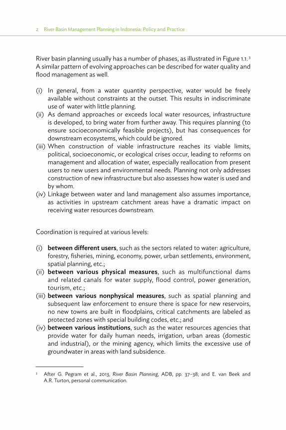
River basin planning usually has a number of phases, as illustrated in Figure 1.1. 3 A similar pattern of evolving approaches can be described for water quality and flood management as well.
(i) In general, from a water quantity perspective, water would be freely available without constraints at the outset. This results in indiscriminate use of water with little planning.
(ii) As demand approaches or exceeds local water resources, infrastructure is developed, to bring water from further away. This requires planning (to ensure socioeconomically feasible projects), but has consequences for downstream ecosystems, which could be ignored.
(iii) When construction of viable infrastructure reaches its viable limits, political, socioeconomic, or ecological crises occur, leading to reforms on management and allocation of water, especially reallocation from present users to new users and environmental needs. Planning not only addresses construction of new infrastructure but also assesses how water is used and by whom.
(iv) Linkage between water and land management also assumes importance, as activities in upstream catchment areas have a dramatic impact on receiving water resources downstream.
Coordination is required at various levels:
(i) between different users, such as the sectors related to water: agriculture, forestry, fisheries, mining, economy, power, urban settlements, environment, spatial planning, etc.;
(ii) between various physical measures, such as multifunctional dams and related canals for water supply, flood control, power generation, tourism, etc.;
(iii) between various nonphysical measures, such as spatial planning and subsequent law enforcement to ensure there is space for new reservoirs, no new towns are built in floodplains, critical catchments are labeled as protected zones with special building codes, etc.; and
(iv) between various institutions, such as the water resources agencies that provide water for daily human needs, irrigation, urban areas (domestic and industrial), or the mining agency, which limits the excessive use of groundwater in areas with land subsidence.
3 After G. Pegram et al., 2013, River Basin Planning, ADB, pp. 37–38; and E. van Beek and A.R. Turton, personal communication.
Introduction 3
Figure 1.1: Evolution in Techniques: From Development of Infrastructure to Demand Management
Water use
Sustainablewater availability
Demandmanagement
Water
Waterresources
infrastructure
Waterquantity
Time
Getting more
Phases: Supply driven Demand oriented Adaptive
End-usee�ciency
Allocativee�ciency
Adaptive to absolute scarcity
Perceptions:
Food policy:
Resource base:
Discursive elites
Water as free good
National self-su�ciency
Depleting/deteriorating
Water as a scarce goodWater as economic good
National resource reconstruction
Engineersand hydrologists Ecologists
Politicians
Economics and social scientists
Food security with virtual water as a coping strategy
Source: G. Pegram, E. van Beek, A.R. Turton, et al.

4 River Basin Management Planning in Indonesia: Policy and Practice
Alongside the major governance reforms in response to the monetary crisis of 1998, Indonesia had also developed promising policies for the application of IWRM, and partly making use of these developments. The Water Resources Adjustment Program (WATSAP) merits a special mention, as it provided a platform, work program, and funding for major changes. This resulted in a legislative framework, based on Water Law 7/2004 and subsequent regulations, and the establishment of new institutions for IWRM. Indonesia has been divided into 131 river basin territories (RBTs [Wilayah Sungai]) based on hydrological boundaries, bringing together all stakeholders with a common interest in sustainable use of water resources in that area. This has been enhanced by support through new river basin organizations dedicated to that area and a platform where all the stakeholders can meet the Basin Council (TKPSDA) to settle disputes or seek win–win solutions.
BWRMP, which aims for IWRM, is based on Law 7/2004 and related regulation as explained in this report. Its guidelines specify that all aspects of IWRM (conservation, water utilization, and damage control) as well as all interests of stakeholders (information management and participation) should be addressed. The procedures involved provide opportunities for all stakeholders to influence the process of formulation or the final result through public consultation meetings, public announcement, and objection procedures; endorsement by the Basin Council; and finally by the highest authority in the area (head of district, head of province, or minister of public works), depending on the status of the RBT.
However, it should be mentioned that Law 7/2004 and many other laws in Indonesia are prepared to be focused on a specific sector, with the main sponsor from a certain ministry or even one director general from that ministry, which is not always conducive for integrated management. For instance, Law 7/2004 focuses on surface water, addressing conservation as part of its interest area, but conservation of critical watersheds, pollution control, groundwater management, and spatial planning are dealt with in separate laws and regulations. In an ideal situation, during preparation of the law, all major institutions and stakeholders are consulted for their inputs, which are supposedly incorporated into the integrated approach. But during implementation of the laws and regulations, often some rules are conflicting, serving various vested interests. It is left to the personal efforts of the local leaders to settle the differences and ensure that integrated development and IWRM takes place.

Introduction 5
Basin Water Resources Management Planning is based on Law 7/2004 and related regulation as explained in this publication. It aims for Integrated Water Resources Management, and the guidelines specify that all aspects of Integrated Water Resources Management (conservation, water utilization, and damage control) as well as interests of all stakeholders (information management and participation) should be addressed.
This publication is mainly based on the experience gained in basin water resources management planning during Technical Assistance TA 7189-INO: Institutional Strengthening for Integrated Water Resources Management in the 6 Cis River Basin Territory (Package B) Project of the Asian Development Bank (ADB). This study was financed by ADB and the Netherlands, and implemented under the executing agency of the Directorate General for Water Resources (DGWR) in the Ministry of Public Works (MPW) from September 2009 to February 2013 by a consortium led by DHV Consultants with, among others, Deltares and DEMIS from the Netherlands and many Indonesian consultancy firms. The aim of this project was to set a good example of formulation of Pola and Rencana in Indonesia, using the example of the most complex RBT/WS of Cidanau–Ciujung–Cidurian–Cisadane–Ciliwung–Citarum or 6 Cis (six rivers). The area, located on the northwest part of Java, is politically and economically very important, covering the national capital of Jakarta and the provincial capitals of Bandung and Serang, an area of 25,000 square kilometers with 45 million inhabitants and generating 30% of national gross domestic product (GDP).
This report aims to share the wealth of information concerning policies and practices in BWRMP, developed under the 6 Cis project as well as under other projects in other parts of Indonesia, with a wide audience of planners, not only in the water sector but also in other sectors, as well as other interested persons, both in Indonesia and other Asian countries (where rapid economic growth is stretching the limits of potential water resources development), and also the rest of the world. Much of the experience gained during the early implementation of IWRM in Indonesia and the implementation of the 6 Cis4 program has been used, augmented with experiences from other basins, as well as interviews with key persons and relevant reports as specified in Chapter 6.
4 TA 7189: Institutional Strengthening for Integrated Water Resources Management in the 6 Cis River Basin Territory, DGWR, and ADB.

6 River Basin Management Planning in Indonesia: Policy and Practice
The outcome of this publication is expected to be a contribution to
(i) inspiring other basin planners and other agents for development in Indonesia and abroad, to make optimal use of the experiences gained in Indonesia; and
(ii) making decision makers better informed and aware of the strengths and weaknesses of basin planning. It is assumed that this publication will enhance their decisions concerning IWRM, reflected in better Terms of References, budgets, and creating a conducive environment for adequate integration of basin planning, development, and implementation of IWRM.

2 Global and Indonesian Principles of Integrated Water Resources Management and Basin Water Resources Management Planning
2.1. Global Objectives
After the Dublin Statement 1992, Integrated Water Resources Management (IWRM) emerged as the driving concept behind the management of water resources. Now, 20 years later, the concept of IWRM has been accepted
worldwide as the best way to improve water management. An inventory by the United Nations Environment Programme (UNEP)5 shows that, by 2012, 80% of the countries in the world had embarked on reforms to improve the enabling environment for water resources management (WRM) based on the application of IWRM.
The Global Water Partnership (2000) has defined IWRM as
a process, which promotes the coordinated development and management of water, land and related resources, in order to maximize resultant economic and social welfare in an equitable manner without compromising the sustainability of vital ecosystems.
The prime objective of IWRM, as its definition suggests, is to support economic development and social well-being. Water is a critical—but sometimes overlooked—condition for sustainable development. Reliable and readily accessible supplies of unpolluted water improve living conditions and reduce child mortality. Water is a key ingredient in generating rural livelihoods, growing food, producing energy that encourages industrial and service sector growth, and ensuring the integrity of ecosystems and the produce they provide. But water
5 UNEP. 2012. UN Water Status Report: Application of Integrated Approaches to Water Resources Management.

8 River Basin Management Planning in Indonesia: Policy and Practice
also poses its own challenges in development in the form of floods, droughts, and water-related diseases, which can have huge impacts on communities and national economies.
The importance of good water management for socioeconomic development is clearly demonstrated by Grey and Sadoff (footnote 1) by linking the extent to which countries harness their water resources to improve their economic performance. Countries that are hostage to inadequate supply of water or poor water management are typically among the world’s poorest. Interventions in the water system, especially infrastructure investments, as suggested by Grey and Sadoff, would help mitigate the situation to a great extent.
2.2. Global Key Principles and Concepts of Integrated Water Resources Management
Population growth and economic development have placed an enormous pressure on the water resource systems in many parts of the world. The resultant state of the water systems (too little, too much, too dirty) have major impacts on people, economy, and ecology. Solving these issues requires an integrated approach to WRM in which the actual use of water for livelihood is balanced against maintaining the water systems as a resource base. We need to integrate the various elements of the natural system (surface water and groundwater, quantity and quality, upstream and downstream, etc.) with the use of water by people (the various sectors, governance, relation with economic development and spatial planning, etc.). IWRM is based on the four Dublin principles, as given in Box 2.1.
Box 2.1: Dublin Principles on Integrated Water Resources Management
(i) Fresh water is a finite and vulnerable resource, essential to sustain life, development, and the environment. Since water sustains life, effective management of water resources demands a holistic approach, linking social and economic development with protection of natural ecosystems. Effective management links land and water uses across the whole of a catchment area or groundwater aquifer.
(ii) Water development and management should be based on a participatory approach, involving users, planners, and policy makers at all levels. The participatory approach involves raising awareness of the importance of water among policy makers and the general public. It means that decisions are taken at the lowest appropriate level, with full public consultation and involvement of users in the planning and implementation of water projects.
continued on next page
Global and Indonesian Principles 9
IWRM has moved us from a subsectoral approach to a cross-sectoral approach (water for people, food, ecosystems, and industry), preferably to be applied at a basin scale to include the upstream–downstream aspects. The ultimate goal is to achieve a water system which is economically efficient, socially equitable, and environmentally sustainable. This requires the three “pillars of IWRM” consisting of an enabling environment, a good institutional framework, and the availability of management instruments. Together, they enable us to make a good balance between “water for livelihood” and “water as a resource.” This is illustrated in Figure 2.1.
How best IWRM can be applied depends on the specific situation. IWRM is applied at different scales: national, river basin, and local, preferably in a hierarchical order. A national IWRM plan determines the overall objectives and the main strategic directions of the development and management of water resources in the country. Such a national plan constitutes the boundary condition for the development of IWRM plans at a basin level, which, in turn, determines the boundary conditions for local IWRM plans, for example, for a city.
It is important to note that IWRM invented in 1992 is not a totally new concept. Long before the formal conceptualization of IWRM in Dublin, integrated water
(iii) Women play a central part in the provision, management, and safeguarding of water. This pivotal role of women as providers and users of water and guardians of the living environment has seldom been reflected in institutional arrangements for the development and management of water resources. Acceptance and implementation of this principle requires positive policies to address the specific needs of women and to equip and empower women to participate at all levels in water resources programs, including decision making and implementation, in ways defined by these women themselves.
(iv) Water has an economic value in all its competing uses and should be recognized as an economic good. Within this principle, it is vital to recognize first the basic right of all human beings to have access to clean water and sanitation at an affordable price. Past failures to recognize the economic value of water has led to wasteful and environmentally damaging uses of the resource. Managing water as an economic good is an important way of achieving efficient and equitable use, and of encouraging conservation and protection of water resources.
Source: Global Water Partnership conference in Dublin, procedures (1992).
Box 2.1 continued

10 River Basin Management Planning in Indonesia: Policy and Practice
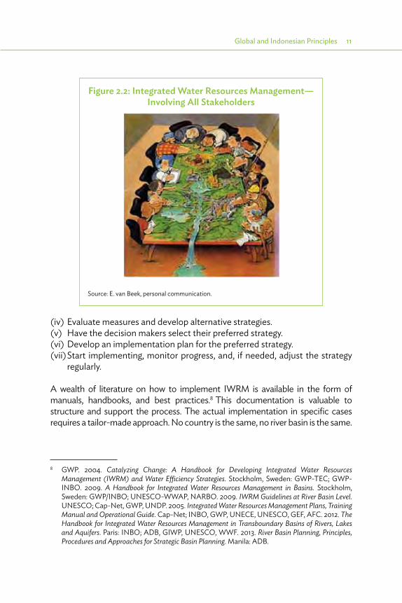
management was practiced to a certain degree in many countries. Subsequent Basin Water Resources Master Plans for Brantas Basin6 carried out between 1961 and 1985 in Eastern Java and the so-called BTA-155 project7 carried out between 1986 and 1990 in Western Java, Indonesia, are good examples of integrated water resources studies carried out before “Dublin.” But, it was “Dublin” that formalized the concept and approach of IWRM and gave directions on how to apply it, in particular in planning. This is illustrated in Figure 2.2, and further elaborated on below.
The process leading to IWRM comprises the following steps:
(i) Bring the stakeholders together around the table.(ii) Discuss with the stakeholders the water resources issues and (present and
future) problems.(iii) Jointly determine what is to be achieved (the objective) and how it is to be
measured (the criteria or indicators).
6 Directorate General of Water Resources Development, Brantas Authority, 1961, 1973, 1985, and 1998, WR Master Plan for Brantas Basin, PJT I, Malang, Indonesia.
7 Directorate General of Water Resources Development, Delft Hydraulics, 1989, Cisadane-Cimanuk Integrated Water Resources Development (BTA-155), DGWRD/Deltares.
Figure 2.1: General Framework of Integrated Water Resources Management
Economic e�ciency Equity Environmentalsustainability
Management instruments� Assessment� Information� Allocation of
instruments
Enabling environment� Policies� Legislation
Institutional framework� Central–local� River basin� Public–private
Balance “water for livelihood” and “water as a resource”
Source: Global Water Partnership. 2000. Integrated Water Resources Management. Technical Advisory Committee (TAC) Background Papers. No. 4. Stockholm, Sweden.
Global and Indonesian Principles 11
(iv) Evaluate measures and develop alternative strategies.(v) Have the decision makers select their preferred strategy.(vi) Develop an implementation plan for the preferred strategy.(vii) Start implementing, monitor progress, and, if needed, adjust the strategy
regularly.
A wealth of literature on how to implement IWRM is available in the form of manuals, handbooks, and best practices.8 This documentation is valuable to structure and support the process. The actual implementation in specific cases requires a tailor-made approach. No country is the same, no river basin is the same.
8 GWP. 2004. Catalyzing Change: A Handbook for Developing Integrated Water Resources Management (IWRM) and Water Efficiency Strategies. Stockholm, Sweden: GWP-TEC; GWP-INBO. 2009. A Handbook for Integrated Water Resources Management in Basins. Stockholm, Sweden: GWP/INBO; UNESCO-WWAP, NARBO. 2009. IWRM Guidelines at River Basin Level. UNESCO; Cap-Net, GWP, UNDP. 2005. Integrated Water Resources Management Plans, Training Manual and Operational Guide. Cap-Net; INBO, GWP, UNECE, UNESCO, GEF, AFC. 2012. The Handbook for Integrated Water Resources Management in Transboundary Basins of Rivers, Lakes and Aquifers. Paris: INBO; ADB, GIWP, UNESCO, WWF. 2013. River Basin Planning, Principles, Procedures and Approaches for Strategic Basin Planning. Manila: ADB.
Figure 2.2: Integrated Water Resources Management— Involving All Stakeholders
Source: E. van Beek, personal communication.

12 River Basin Management Planning in Indonesia: Policy and Practice
2.3. Global Experience with Integrated Water Resources Management and Future Developments
After being in vogue for 20 years, one can conclude that IWRM is well-established worldwide. But how effective is it? Does it reach its goal of socioeconomic development and sustainability? It is difficult to draw general conclusions: each application is different due to varying physical, economic, social, and institutional conditions. Moreover, IWRM is evolving as we are learning from our mistakes and improvements are being made to concepts and approaches. Some lessons can be listed and most of these lessons result from overly high expectations and misinterpretations of the concept. IWRM is not a magic pill that cures all ailments.
The first lesson is that IWRM should not be seen as a prescription, but rather as an approach offering a framework within which water-related problems and issues can be addressed. The basic steps, problems–objectives–alternatives–decisions in participatory setting, are always the same but how they are addressed depend on specific conditions.
The second lesson is that working on a multisectoral scale requires a willingness to compromise. In many cases, IWRM may help to find win–win situations. But in some cases, trade-offs need to be made to optimize economic growth, social equity, and environmental sustainability, especially where resources (as water and funds) are scarce. IWRM by itself does not make those trade-offs. A strong involvement of the stakeholders and decision makers in the process is needed to find the required compromises.
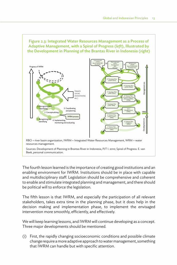
The third lesson is to realize that IWRM is a process and not a goal by itself. The process of IWRM will step by step improve water management in a country or river basin. To illustrate this, UNESCO/NARBO (Network of Asian River Basin Organizations) introduced the spiral of IWRM, as presented in Figure 2.3, based on the experiences in Brantas (1961–1998) as indicated above.
Conditions may require that management at times has to pay more attention to certain aspects of the full IWRM system, for example, after a serious flooding has taken place. This can be accommodated in IWRM as long as these more focused or sectoral developments take into account the full picture and a balancing of interests takes place. A spiral approach to IWRM is also needed to adapt the system to changing conditions, for example, with respect to socioeconomic developments and climate change.
Global and Indonesian Principles 13
The fourth lesson learned is the importance of creating good institutions and an enabling environment for IWRM. Institutions should be in place with capable and multidisciplinary staff. Legislation should be comprehensive and coherent to enable and stimulate integrated planning and management, and there should be political will to enforce the legislation.
The fifth lesson is that IWRM, and especially the participation of all relevant stakeholders, takes extra time in the planning phase, but it does help in the decision making and implementation phase, to implement the envisaged intervention more smoothly, efficiently, and effectively.
We will keep learning lessons, and IWRM will continue developing as a concept. Three major developments should be mentioned.
(i) First, the rapidly changing socioeconomic conditions and possible climate change require a more adaptive approach to water management, something that IWRM can handle but with specific attention.
Figure 2.3: Integrated Water Resources Management as a Process of Adaptive Management, with a Spiral of Progress (left), Illustrated by
the Development in Planning of the Brantas River in Indonesia (right)
1st Master Plan(Flood prevention)
(1961)
3rd Master Plan(Urban water)
(1985)
1st Strategic Plan(1994-1998)
2nd Strategic Plan(1999-2003)
2nd Master Plan(Irrigation)
(1973)
4th Master Plan(Conservation and
eective WRM)(1998)
PJT IEstablishment
(1990)
3rd Strategic Plan(2004-2008)
Long-term goal(2025)
Benchmarked RBOAsia Pacific
Midterm goal(2020)
Benchmarked RBOSoutheast Asia
Short-term goal(2015)
BenchmarkedRBO
Indonesia
4th Strategic Plan(2009-2013)
Impacts(social,environmental,etc.)
Progress of IWRM
3. Coordinating and planning
4. Implementing, monitoring and evaluating
2. Conceptualizing 1990
1
2
3
4
5
6
7
8
9
1110
Deve
lopm
ent e
raM
anag
emen
t era
IWRM process1. Recognizing and identifying
5. Recognizing and identifying
RBO = river basin organization, IWRM = Integrated Water Resources Management, WRM = water resources management.
Sources: Development of Planning in Brantas River in Indonesia, PJT I. 2010; Spiral of Progress. E. van Beek, personal communication.

14 River Basin Management Planning in Indonesia: Policy and Practice
(ii) The second is the so-called water–food–energy nexus, which requires IWRM to prioritize the objectives of food security and energy security ahead of WRM.
(iii) The last major development to be mentioned is the use of the concept of water security to express the end goal of IWRM: realizing a water-secure world. The concept identifies various dimensions of water security and enables quantification of how good our water management is or how much better it could be. The Asian Water Development Outlook 20139 described water security in Asia and the Pacific using five key dimensions: household water security, economic water security, urban water security, environmental water security, and resilience to water-related disasters. The National Water Council in Indonesia describes water security as
sustainable fulfillment of water needs in adequate quantity and quality for a healthy, clean and productive living of the community and capability to contain the risk for damage related to water below a clear level.10
9 ADB. 2013. Asian Water Development Outlook 2013. Measuring Water Security in Asia and the Pacific. Manila.
10 Dewan Sumber Daya Air Nasional (March 2013), own translation.
Project start Decision making
Project start ImplementationDecision making
It takes time, but it does help.
Noparticipation
Participation
Implementation
Source: E. van Beek, personal communication.

Global and Indonesian Principles 15
2.4. Integrated Water Resources Management Application and Basin Planning in Indonesia
2.4.1. Integrated Water Resources Management Application in Indonesia
Indonesia has implemented bold reforms since 1998, leading to new laws and regulations and an enabling environment for IWRM. However, application of IWRM in Indonesia is still difficult, because WRM is neither a national priority nor a leading sector for national and regional development. Therefore, the many efforts to formulate integrated WRM plans have only been effective for parts of the water sector, but have failed to achieve synchronized broad application in all sectors involved, not only in the water sector but also in other sectors from a cross-sectoral perspective. Since application by various institutions is one of the main aspects of IWRM, in general, application of IWRM has not been effective. The present review of the 5-year development plan (RPJM) offers an opportunity for the new president to advocate WRM as a priority to achieve IWRM.
To realize an effective IWRM approach, planning activities of one sector should be embedded in the national and regional development planning framework, to obtain adequate institutional and financial support. This comprises long-term plans (RPJP), usually with a time horizon of 25 years, short-term development plans (RPJM), and specific plans for specific purposes, both at the national and the regional levels (RPJPD and RPJMD). The RPJP and RPJM at the national level do not recognize WRM as a focus point, and therefore focus on WRM is missing even at the regional level. Most of the already completed and endorsed WRM plans have not been sufficiently embedded in the regional RPJM, and therefore lacks adequate support from the other sectors and also in the allocation of budget.
From 2004 to 2014, President Susilo Bambang Yudhoyono presided over Indonesia during two 5-year terms in office. During his first term, the 25-year-plan (RPJP)was issued in 2007 by UU 17/2007. For both terms, an RPJM was formulated, the last in PerPres No. 5/2010. None of these recognize WRM as a national priority, although some water aspects are included in part of the priorities as specified in Table 2.1. During his second term, a special development plan was formulated in PerPres No. 32/2011 (titled the Masterplan for the Acceleration and Expansion of Indonesia’s Economic Development, 2011–2025 [MP3EI]). In the MP3EI, development is based on three pillars: (i) developing
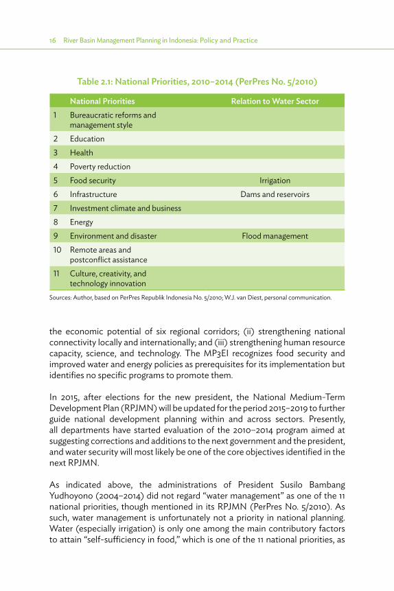
16 River Basin Management Planning in Indonesia: Policy and Practice
the economic potential of six regional corridors; (ii) strengthening national connectivity locally and internationally; and (iii) strengthening human resource capacity, science, and technology. The MP3EI recognizes food security and improved water and energy policies as prerequisites for its implementation but identifies no specific programs to promote them.
In 2015, after elections for the new president, the National Medium-Term Development Plan (RPJMN) will be updated for the period 2015–2019 to further guide national development planning within and across sectors. Presently, all departments have started evaluation of the 2010–2014 program aimed at suggesting corrections and additions to the next government and the president, and water security will most likely be one of the core objectives identified in the next RPJMN.
As indicated above, the administrations of President Susilo Bambang Yudhoyono (2004–2014) did not regard “water management” as one of the 11 national priorities, though mentioned in its RPJMN (PerPres No. 5/2010). As such, water management is unfortunately not a priority in national planning. Water (especially irrigation) is only one among the main contributory factors to attain “self-sufficiency in food,” which is one of the 11 national priorities, as
Table 2.1: National Priorities, 2010–2014 (PerPres No. 5/2010)
National Priorities Relation to Water Sector1 Bureaucratic reforms and
management style2 Education3 Health4 Poverty reduction5 Food security Irrigation6 Infrastructure Dams and reservoirs7 Investment climate and business 8 Energy9 Environment and disaster Flood management10 Remote areas and
postconflict assistance11 Culture, creativity, and
technology innovationSources: Author, based on PerPres Republik Indonesia No. 5/2010; W.J. van Diest, personal communication.

Global and Indonesian Principles 17
shown in Table 2.1. Water is also part of the infrastructure priority program, and flood management is part of the environment and disaster priority program. These three areas are covered in the strategic plan of the Ministry of Public Works (MPW) (RENSTRA 2010–2014).
However, the water sector in Indonesia undertook bold reforms in 1998–2005, leading to new laws and regulations as well as an enabling environment for IWRM. This started in 1990 with the establishment of river basin management units with hydrologically defined boundaries (river basin units or Satuan Wilayah Sungai [SWS]). Early master plans for these SWS indicated a shift from the then current development approach toward a more comprehensive and sustainable management approach.
This further culminated in the new Water Resources Law (7/2004), using the momentum of the reforms and adopting the principles of IWRM. Features of the IWRM principles in this law are as follows. First, three substantive components [(i) conservation, (ii) utilization, and (iii) water safety], and two supportive components, [(iv) data management and (v) public participation], are identified. Second, coordination to safeguard the interests of the different sectors and stakeholders is introduced through the required establishment of coordinating platforms in the National Water Council (Dewan SDA Nasional), Provincial Water Council (Dewan SDA Propinsi), and Basin Council (not mandatory, but which resulted in the Basin Water Resources Management Council [TKPSDA]).
Third, the whole Indonesia has been divided based on RBTs. RBTs or Wilayah Sungai (WS) are areas with hydrological boundaries, comprising one or more river basins. Recently,11 131 WS have been defined in Indonesia as further specified in Section 3.3.
Fourth, basin planning with public participation was made a legal requirement at the level of the RBTs (WS), which already resulted in many strategic framework plans (Pola) and several more detailed master plans (Rencana), as reported in Section 2.6.
However, these achievements have not yet been properly embedded and mainstreamed in national policies. As such, the huge efforts for IWRM implementation based on new laws and regulations are mainly supported by agencies related to the water sector, especially the MPW. Mainstreaming should be through incorporation in national policies such as the long-term and
11 Presidential Decree No.12/2012 concerning river basin territory.

18 River Basin Management Planning in Indonesia: Policy and Practice
midterm national development plans (RPJP and RPJM), which will be followed up by regional development plans (RPJPD and RPJMD) and spatial planning, requiring the other sectors (food, energy, health, environment, forestry, etc.) to formulate strategic plans (RENSTRA) and allocate budgets for activities supporting IWRM. Only if this is achieved (during current formulation of RPJM for the new president), would the current BWRM Plans be used as guidelines for agencies in the other sectors, including them in their RENSTRA and annual work plans (AWPs) and budget allocations.
In issuing PerPres No. 33/2011 on national policy for water management, a first step toward mainstreaming IWRM in the other sectors was made. This PerPres was prepared after extensive discussions in the National Water Council to promote “water management” as national policy. Six national policy requirements are identified, in line with the main components of Law 7/2004: (i) general policy, (ii) policy on sustained conservation of water resources, (iii) policy on fair and equal application of water resources, (iv) policy on water damage control and impact, (v) policy on enhanced involvement of the general public and the private sector in WRM, and (vi) policy on development of water resource data management system. The PerPres was followed up by the Coordinating Minister of Economic Development (Menko Ekuin) on 8 May 2012 with the issuance of a 155-page action plan (Matrix Tinak Lanjut Pelaksanaan Kebijakana Nasional Sumber Daya Air).
The National Water Council is currently pursuing a program, “water management” (referred to as “Water Security” or Ketahanan Air), which during the tenure of the next government (2015–2020) will become a national development policy to allow for sustained attention by all sectors for all matters related to IWRM. This should be followed up with incorporation of the already formulated water management plans (Pola and Rencana) in the provincial development plans (RPJPD and RPJMD). Only after this condition is met, can the implementation of these water management plans be realized.
2.4.2. Basin Water Resources Management Planning in Indonesia
Basin planning is a useful method to identify constraints and find promising solutions to develop and manage water resources in a basin. A rational system analysis approach (a straightforward process aiming at progress, preferred by engineers) is illustrated in Figure 2.4 under “Contents.” However, based on Dublin IWRM principle 2 (participatory approach), this planning should involve all relevant stakeholder interests for optimal and sustainable solutions.

Global and Indonesian Principles 19
Therefore, the rational approach should be combined with a more interactive process, not focused on products, but more on consensus. This “Process” approach is illustrated in the left part of Figure 2.4.12
The Water Resources Law (7/2004) requires the preparation of “Pola” (Framework or Strategic Plan) and “Rencana” (Master Plan) for each of the 131 RBTs (WS). This will be addressed in detail in Chapter 4. In the Citarum basin, Pola and Rencana were preceded by the development of a Road Map, which is the vision of the government and relevant stakeholders on how to incrementally develop the basin, and this approach can be used in addition to the legal framework as addressed in Chapter 4, but this is not required by law or later regulations. Finally, routine reporting of the state of the basin is proposed, as addressed in Chapter 5. The sequence of these documents (road map, Pola,
12 The Java Irrigation and Water Resources Management Project (JIWMP, World Bank, and DGWR 1994–2000) comprised three core components: (1a) Basin Water Resources Planning (BWRP) addressing the planning aspects and (1b) Basin Water Resources Management (BWRM) addressing the institutional and management aspects, besides (2) Irrigation. To identify the change from a technical approach to basin planning (resulting mainly in wish lists for new developments) to a more integrated approach, the name of the BWRP component was changed, in 2000, to Basin Water Resources Management Planning (BWRMP).
Figure 2.4: Policy Analysis Approach to Basin Planning in 6 Cis River Basin Territory
Awareness raising
Mobilizing actors
Dialogue
Link problems to solutions
Negotiate contributions
Fix commitment
Monitoring and complaint
Identify issues
Analyze problems
Design and assess alternative
Select alternative
Action planning
Implementation
Evaluation
System analysis approach
Pola
Rencana
State of basinreporting
Process ContentRoad map
6 Cis = Cidanau–Ciujung–Cidurian–Cisadane–Ciliwung–Citarum or 6 Cis (six rivers).
Source: 6 Cis inception report.

20 River Basin Management Planning in Indonesia: Policy and Practice
Rencana, and State of Basin Report) in relation to the process steps of the policy analysis approach as applied in the 6 Cis project is illustrated at the far right side of Figure 2.4.
Developing and implementing these plans, and integrating them in the other plans of the region, require a strong institutional setting. River basin organizations (RBOs) have been set up with clearly described institutional status and with mandates for WRM in the RBTs (WS). They are called Basin WRM Centers or Balai (Besar) Wilayah Sungai [B(B)WS] if they are under the central government, or Balai Pengelolaan Sumber Daya Air (Balai PSDA) if they are under the province.
Also, coordinating platforms have been established: national and provincial water councils (Dewan SDA) and Basin WRM Councils (TKPSDA) for coordination within the water sector, but also for coordination with other sectors, such as the coordinating platform for spatial planning, platforms for coordination of catchment management (Forum DAS), etc., as described in Section 2.4.5 and in more detail in Section 6.5.
As described in the previous section, application of IWRM is a learning process. The Pola and Rencana planning approach in Indonesia was initiated in 2004 based on Water Resources Law (7/2004). Since then, Framework or Strategic Plans (Pola) have been prepared for most of the 131 RBTs in Indonesia (see Section 2.6). Not all plans lived up to the expectations of the supervising organization at the Ministry of Public Works and Housing, and actually many early versions of plans have been rejected by supervising organizations as they did not comply with the legal conditions for these plans.
IWRM is not a goal by itself. IWRM aims to support economic and social welfare. As such, it should be seen as a service, which water agencies at the national, provincial, and district levels provide to the public and the economic sector, and for all other relevant sectors. For that reason, the Pola and Rencana should take the objectives and programs of other sectors (Millennium Development Goals, agriculture, energy, public health, environment, spatial planning, etc.) as starting conditions, and develop initiatives to support these objectives and programs. After formulation of the plan, these sectors should see Pola and Rencana as instruments they can use to realize their objectives. They should “own” the plans. A problem in this respect is that the translation of national objectives (e.g., on food and energy, infrastructure, and disaster) in Indonesia, or on local objectives (such as flood protection for various types of land use), is usually insufficiently specified as boundary conditions for management of RBTs.

Global and Indonesian Principles 21
As such, basin plans are supposed to be based on existing regional strategic plans such as provincial and district development plans (RPJM/RPJP), spatial plans (RTRW), catchment conservation plans (Rencana BPDAS), and many sectoral plans. As mentioned in Section 2.4.1, it is essential for implementation of these plans that they are incorporated in the updated RPJM/RPJP through close contact with the Regional Development Planning Agency (BAPPEDA) and subsequently in spatial plans and other sectoral plans. The basin plans should also be integrated with basin plans of neighboring basins for priority setting and assessment of potential mutual assistance as done for the island-based Java Water Resources Strategic Study (JWRSS).13 This process is illustrated in Figure 2.5.
Spatial plans are cross-sectoral instruments, and therefore, are highly relevant for IWRM as explained in Section 2.4.3. Both Water Resources Law 7/2004 and Spatial Planning Law 26/2007 mention that both plans should be integrated, but in practice this is followed only occasionally.
13 DHV, Wiratman and MLD consulting firms. 2012. Java Water Resources Strategic Study (JWRSS). DGWR and World Bank.
Figure 2.5: Position of Basin Plan Related to Other Strategic Plans
Pola WS2008
RTRW2010
KebijakanSDA
Nasional
Review Pola
RencanaWS
RTRW 2015RPJM/RPJP
Dewan SDAProp
ReviewRencanaP-DAS
ReviewRencana
Pertanian
ReviewLingkungan
RencanaP-DAS
RencanaLingkungan
RencanaPertanian
Pola/Rencana
PSDA WS2014
P-DAS= Rencana Pengelolaan Daerah Aliran Sungai = Watershed Management (i.e., by Ministry of Forestry), PSDA = Pengelolaan Sumber Daya Air, = Water Resources Management, RPJM = Rencana Pembangunan Jangkwa Menengah = Mid Term Development Plan, RPJP = Rencana Pembangunan Jangka Panjang = Long Term Development Plan, RTR W = Rencana Tata Ruang Wilayah = Regional Spatial Plan (Province or District / City), SDA = Sumber Daya Air= Water Resources, WS = Wilaya Sungai = RBT = river basin territory.Source: Author, revised from Java Water Resources Strategic Study, Deltares et al. for DGWR and World Bank. 2012.

22 River Basin Management Planning in Indonesia: Policy and Practice
2.4.3. Principles for Integration of Basin and Spatial PlanningIn continuation of the definition of IWRM, the coordination of basin planning and spatial planning requires intensive coordination to develop and manage water, land, and related resources. This is now receiving attention in many countries. For example, the European Union (EU) Water Framework Directive, seen by many as “Sustainability Directive,” strongly emphasizes the need for closer ties between river basin management and land use planning. At the same time, European guidance on spatial planning promotes the idea of incorporating wider social and environmental objectives within planning decisions. Therefore, these two drivers should promote greater integration between spatial planning systems and the river basin planning system associated with the EU Water Framework Directive.
However, in most countries, building linkages between these two systems requires strong efforts in bridging separate policies and institutions. There is limited understanding of how this integration might be accomplished, or what it means in practical terms for key stakeholders (particularly planners). This section deals with a possible approach for the integration of basin planning and spatial planning in the Indonesian setting.
Land use and water management have strong interrelationships. This is illustrated by the fact that more urban area leads to larger hard surfaces, reduced infiltration, increased and faster runoff from rainfall, and possibly reduced base flow in dry season. Also, certain land uses enhance erosion, increasing sedimentation in the riverbeds (higher chance of flooding) or in reservoirs (reducing storage capacity). There is also a clear need for regulation on settlement in flood-prone areas to limit flood risks.
Establishing sustainable water resources requires interventions/regulations which can only be established through spatial management. For example, conservation planning and implementation will be necessary to restore/upgrade/maintain water-related functions to establish sustainable water systems. These measures are under increasing pressure from increasing settlements, and such conservation can only be realized by specifying protective water zoning, incorporated in the overall spatial plan. At the same time, spatial development needs to be supported (made possible) by sufficient water resources development; therefore, projections of (alternative) spatial activity patterns form inputs to water resources development.

Global and Indonesian Principles 23
Figure 2.6: Integrated Spatial Planning and Water Resources Planning
Water resourcesplanning
(river basin scope)
Water zoningrequirements
Spatial planning(national,
island scope)
Projections forland use
Input from spatialplanning to water resources
management plan
Input from water
zoning tospatial planning
Conflict resolution; valuationof alternative land use
Source: 6 Cis Inception Report. 2010.
Box 2.2: Integration of Spatial Planning and Water Resources Planning
• �Spatial�planning�inputs�to�the�basin�plan�in�terms�of�consistent�projections�for�land use, population, and other socioeconomic factors, as well as the spatial plans with (future) land allocations
• �Water�zoning�requirements�from�basin�planning�as�input�to�spatial�plans
Source: Author, based on Figure 2.6 and the 6 Cis Inception Report. 2010.
Therefore, integration of spatial planning and water resources planning comprises two main inputs (as illustrated in Box 2.2 and Figure 2.6, as derived from the 6 Cis project):

24 River Basin Management Planning in Indonesia: Policy and Practice
The existing laws recognize this interrelationship: Water Resources Law 7/2004 recognizes the need for integration of the spatial plan(s) (RTRW) with the river basin plans (Pola and Rencana), while Spatial Planning Law 26/2007, requires regulations and guidelines to explain how spatial planning can support the water sector. The 6 Cis study identified the spatial planning and water resources planning processes, and their interactions as sketched in Figure 2.7.
Both laws have clear regulations for vertical relationships. National and provincial plans provide directions for the planning at the district level (vertical coordination), such as the 30% space requirement for forest in districts and 30% open space requirement in cities (Jakarta only had 9% open space in 2009). Moreover, the plan has to be approved by the Minister of Public Works for technical matters and the Minister of Home Affairs for legal and institutional matters. This is a very powerful instrument for the central government to guide formulation of spatial plans at the district level.
Horizontal coordination between the districts is clearly regulated in the spatial planning law through the requirement of spatial plans at the national and provincial levels, as well as island-wide plans and plans for certain specific regions comprising several districts. In the water law, this is not yet clearly regulated. The JWRSS, as mentioned in Section 2.4.2, is an example of an island-wide WRM planning exercise, but this has not yet been replicated in other islands or incorporated in regulation.
Figure 2.7: Water Zoning in Spatial Planning
Pola
Rencana
River basin planningwater systems
Water resources planning
1:25,000
Direction for zoning1:125,000
Criteria for zoning1:50,000
Detailed Kabupatenplan 1:5,000
Regulations, permits1:1,000
Provincial
Kabupaten
Kabupaten
Kabupaten
Planning andImplementation
Zoning spatial planning
Policy/strategy
Pola = Strategic WRM Framework Plan, Rencana = WRM Master Plan, Kabupaten = District: administra-tive level within the province.
Source: 6 Cis Final Report, Package B.2 (Spatial Planning). 2012.

Global and Indonesian Principles 25
Another type of horizontal coordination is required between the various institutions at the government level, serving the various sectors. This is provided by Regulation 50/2009 of the Minister of Home Affairs on coordination in spatial planning, which instructs the governor and bupati or walikota to establish regional spatial management coordination boards (BKPRD) at their respective levels. This is further discussed in Section 3.3.4.
Regulation of interaction between spatial planning and water resources planning is not yet available. The 6 Cis study identified some essential points for interaction and provided the requisite tools (as shown in Figure 2.7 and more in detail in Section 5.3). Both processes go through several phases of policy/strategy formulation, planning, and implementation. Interaction between the two requires adequate information to enable adequate communication in all phases of the process. Adequate information is especially needed on the interactions and, in particular, quantification of the interrelationships and comparison of information from different sources. This is needed to quantify requirements and impacts, and to direct adjustments and adaptations to proposed developments in water resources planning and spatial planning to optimize an overall development.
The 6 Cis study considered the following parts:
(i) Inputs from spatial planning to basin WRM planning:(a) interpretation of existing spatial plans for projection of a comprehensive
pattern of settlement and economic activity in a well-defined and established area (such as Java) over a specific planning horizon as input to proactive planning of development;
(b) impact indicators for consistent projection of population and land use associated with the above projections; and
(c) water demands: water supply for irrigation, domestic and industrial use, or required flood protection resulting from above projections for land use and population as input to WRM planning.
(ii) Inputs from basin WRM planning to spatial planning: a set of water zoning requirements addressing the different aspects of water resources (urban runoff, runoff from upstream catchment, erosion, etc.) which can be influenced by spatial management, as an input to future updates of spatial planning.

26 River Basin Management Planning in Indonesia: Policy and Practice
2.4.4. Progress in Basin Planning in IndonesiaProgress in preparation of Pola and Rencana in Indonesia is indicated on the Ministry of Public Works website: sda.pu.go.id/bpsda/pws (Table 2.2). From Table 2.2, it can be concluded that preparation of Pola is already quite advanced, but that preparation of Rencana still has a long way to go. For a total of 131 WS the number of officially completed Pola is 43 (of which six require official signature from the minister) and 46 are ready for discussion in TKPSDA. In many WS, the exercise to formulate Pola has started, but the draft (Polas) have been rejected by Directorate General for Water Resources at Ministry of Public Works (DGWR) because they were not in accordance with the regulations (formulated before Keputusan Menteri, KepMen 22/2009 was issued, and no public consultation meetings included) or did not comply with the established standards for applied analysis, public consultation, or deliverables. Most progress is seen in the WS under central government responsibility, because of more expertise and financial resources at its disposal. Most provinces are also able to mobilize sufficient expertise and resources, but the districts have serious problems in this regard.
Only one Rencana has been endorsed by the governor (Bodri-Kudus), while two Rencanas (Cimanuk-Cisanggarung and Bengawan Solo) are awaiting official signature from the minister. Seventeen Rencanas have already been
Table 2.2: Overview of Progress in Formulation of Pola and Rencana (Status May 2014)
Finalized DraftIn
ProcessNot
Specified Responsibility TotalPola 35a 19 8 1 Central government 63
8 27 6 12 Province 5315 District 15
43 46 14 28 Total 131Rencana 2a 17 24 20 Central government 63
1 2 50 Province 5315 District 15
3 19 24 85 Total 16a Of the 35 finalized Polas in Wilayah Sungai river basin technology under the auspices of the central
government, six are still awaiting signature from the minister; the two finalized Rencanas are also still awaiting signature from the minister.
Source: Indonesia Ministry of Public Works.

Global and Indonesian Principles 27
endorsed byTKPSDA (such as the one for Progo Opak Serayu) and another 24 are in process for discussion there. Formulation of Rencana was continued in 2014, while legalization process is pending for the new Ministerial Regulation as the Law no. 2/ 2014 was canceled in 2014.
The Water Resources Research and Development Agency (PusAir) has given essential input, especially concerning provision of hydrological data and application of analyzing tools. Consultants assist in the formulation of most Polas and Rencanas, either through firms or individual consultants. B(B)WS or Balai PSDA usually supervises the formulation.
2.4.5. Progress in Formation of Water Resources CouncilsIn line with Law 7/2004, coordinating platforms at the national and provincial levels are mandatory, while coordinating platforms at the basin level (with hydrological boundaries) is allowed. In principle, all councils have 50% of their members from government agencies and 50% from nongovernment entities. Progress in establishing these platforms is as indicated in Table 2.3.
The National Water Council was established in 2009 with 44 members, with the Coordinating Minister for Economy as chair. For daily tasks of the chair, the Minister for Public Works is responsible. There are 22 members from the government—14 ministers, representatives from two government agencies, the Indonesian Institute for Meteorology, Climatology, and Geophysics (BMKG) and the Scientific Institute (LIPI), and six representatives from local governments (three governors and three district heads, each from the East, Central, and the West region)—and 22 nongovernment members.
A total of 28 Provincial Water Councils (Dewan SDA) have been established since 2009, most with equal participation from government and nongovernment members, but some with one extra member from the government. There is no Dewan SDA yet in five provinces, notably Bali.
Currently, there are 35 Basin WRM Councils (TKPSDA). The 14 Basin WRM Councils that were established earlier had to be disbanded because of changes in boundaries of the basins or responsibilities of the Basin WRM Councils, or because of the formation of new districts. The central government is responsible for most of these basins. Details are in Table 2.3.

28 River Basin Management Planning in Indonesia: Policy and Practice
Table 2.3: Overview of Progress in Establishment of Water Councils
FinalizedUnder
AdjustmentIn
ProcessNot
Specified Responsibility TotalDewan SDA(province)
28 5 Province 3328 5 33
TKPSDA(basin)
27 14 9 13 Central government
63
8 45 Province 5315 District 15
35 14 9 73 Total 131SDA = Sumber Daya Air (Water Resources), TKPSDA = Tim Koordinasi Pengelolaan Sumber Daya Air (Basin Water Resources Management Council).
Source: Subdirectorate for institutional guidance in the Directorate General for Water Resources (status May 2014).
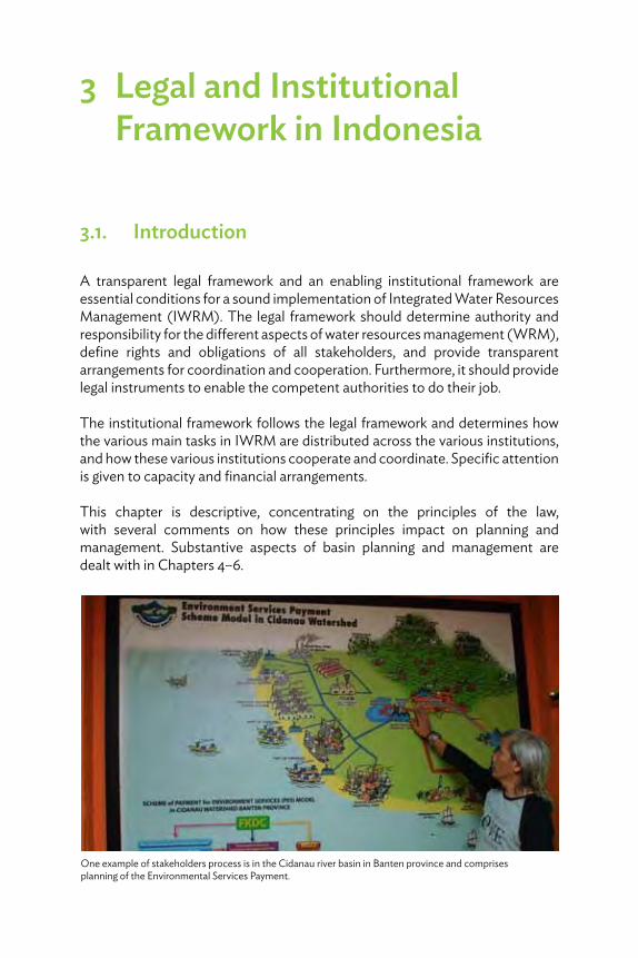
3 Legal and Institutional Framework in Indonesia
3.1. Introduction
A transparent legal framework and an enabling institutional framework are essential conditions for a sound implementation of Integrated Water Resources Management (IWRM). The legal framework should determine authority and responsibility for the different aspects of water resources management (WRM), define rights and obligations of all stakeholders, and provide transparent arrangements for coordination and cooperation. Furthermore, it should provide legal instruments to enable the competent authorities to do their job.
The institutional framework follows the legal framework and determines how the various main tasks in IWRM are distributed across the various institutions, and how these various institutions cooperate and coordinate. Specific attention is given to capacity and financial arrangements.
This chapter is descriptive, concentrating on the principles of the law, with several comments on how these principles impact on planning and management. Substantive aspects of basin planning and management are dealt with in Chapters 4–6.
One example of stakeholders process is in the Cidanau river basin in Banten province and comprises planning of the Environmental Services Payment.

30 River Basin Management Planning in Indonesia: Policy and Practice
3.2. Legal Framework
3.2.1. IntroductionThe legal framework for WRM in Indonesia conforms to modern legislative principles in that the Water Resources Law provides broad outlines of the different aspects, leaving further elaboration and more technical instructions to the lower-level government regulations, ministerial decrees, etc. The material provisions for IWRM have been under development since the 1990s. Table 3.1 describes the Indonesian legal system.
Table 3.1: The Indonesian Legal System
The official hierarchy of Indonesian legislation is enumerated under Law No. 12/2011 on the formulation of laws and regulations:
(i) 1945 Constitution (Undang-Undang Dasar 1945 or UUD’45)
(ii) Decrees of People’s Consultative Assembly (Majelis Permusyawaratan Rakyat or MPR)
(iii) Laws (UU) passed by Parliament (Undang-Undang or UU) and government regulations in lieu of law (Perpu)
(iv) Government regulations (Peraturan Pemerintah or PP) issued by the President, which provide further delineation of the more general provisions in the laws
(v) Presidential regulation (Peraturan President or PerPres) issued by the President, which provide further delineation of provisions in laws or PP
(vi) Provincial regulation (Peraturan Daerah or Perda) issued by the provincial legislative assembly
(vii) District/city regulation (Peraturan Daerah or Perda) issued by the district/city legislative assembly
In addition, there are executive orders:(i) Presidential Decree (Keputusan Presiden or KepPres)(ii) Ministerial Decree (Keputusan Menteri or KepMen) and circulation letters (Surat
Edaran or SE), which are only binding on the relevant ministry (joint KepMens are possible)
Source: Author, personal communication with Bart Teeuwen and Rudolf van Ommen.

Legal and Institutional Framework in Indonesia 31
However, the governance structure introduced by the new legislation was significantly influenced by the drive toward decentralization in the so-called “reformation period” following the demise of the “new order” regime of former President Suharto. The strong, top-down command and control structure of the “new order” regime was replaced by a more democratic system in which most government authorities and responsibilities became enshrined at much lower levels.
Following the initial legislation in 1999, establishing far-reaching administrative and financial autonomy of the districts,14 the process culminated in Law 32 of 2004 on regional government (and the related Law 33 of 2004 on financial relations). These laws create a decentralized government structure in which there is no hierarchical relationship between the different levels of government,
14 Refers to Regional Autonomy Act (Act 22/1999) and Act 25/1999 on financial relations between the central and regional governments. In practice, Act 22/1999 gave rise to numerous questions about the objectives and the consequences of decentralization. In response, the government promulgated new legislation on this subject in 2004: Act 32/2004 (and Act 33/2004 about the fiscal aspects) replacing the previous acts. This Act reestablished some control over regional governments, improved the coordination role of the governor, and also emphasized the tasks of the governor as a central government representative.
Basin planning requires involvement of local government in the district or city administration.
32 River Basin Management Planning in Indonesia: Policy and Practice
all of which are governed by an elected council of representatives and headed by an elected official (national level, president; provincial level, governor; and local level, district head). Perhaps, somewhat contrary to the nonhierarchy principle, the governor acts as ex officio representative of the central government. However, the authority of the governor in this capacity is limited to coordinating between levels and departments of the government—the governor has no immediate material authority over central government assets and/or activities.
Indonesia began moving toward IWRM during the 1990s with the establishment of river basin management units based on hydrologically defined areas (RBTs or Wilayah Sungai) and the formulation of river basin plans for development and management of these territories in Java and some other islands. This represented a significant departure from the former Water Law (Law 11/1974), which mainly focused on project development for irrigation systems. The driving force for modernization of water legislation in Indonesia was the realization that not development but utilization of water resources should be the leading factor, and development of water resources infrastructure should be recognized as a function of utilization of the water resources system. The old Law 11/1974 could not accommodate this, as it did not provide for a structural, integrated approach for the long term.
The new Water Resources Law (referred to as Law 7/2004) formalized the shift in approach from project-oriented development to integrated river basin management. This represents an important milestone in the implementation of IWRM principles in Indonesia.
3.2.2. Main Characteristics of the Law on Water ResourcesLaw 7/2004 on water resources comprises 18 chapters including the ones on definitions, transitional provisions, and date of effectiveness. Three individual chapters deal with the substantive components of IWRM: conservation, utilization, and water safety. Other chapters contain provisions that create and empower the institutional framework:
(i) Attribution of authorities and responsibilities to different levels of government
(ii) Coordination to safeguard the interests of different sectors, levels of administration, and stakeholders
(iii) Main instruments for implementation: planning, financing, and enforcement(iv) Supporting arrangements:
(a) Construction, operation, and maintenance(b) Water resources information system
Legal and Institutional Framework in Indonesia 33
(c) Empowerment of stakeholders and supervision of the WRM process(d) Rights, obligations, and the role of the community(e) Dispute resolution(f) Legal remedies for stakeholders and WRM institutions(g) Investigation
The most important characteristics of Law 7/2004 are the following:
(i) The law is a true management law. It is not primarily about developing water infrastructure and irrigation networks but about creating conditions for responsible and sustainable management of water resources, including but not limited to facilities such as irrigation networks.
(ii) The scope of the law covers the full extent of water management: surface water and groundwater, both in quantitative and in qualitative terms. Thus, it offers a coherent and integrated approach. The guiding principle of the law is the basin approach: water systems (river basins and groundwater basins) with their functional relevant environment are the frame of reference.
(iii) The law approaches WRM from a structural, long-term perspective. It provides for a strategic plan (Pola) for every river basin in which all relevant aspects must be considered and weighed in relation to one another. Furthermore, it provides for a river basin management plan (Rencana) to serve as reference for all types of operational activities. Both should reflect the five “pillars” of IWRM:(a) conservation (quantitative and qualitative),(b) utilization,(c) water safety,(d) information systems, and(e) public participation.
(iv) The law gives local communities and other stakeholders involved in water management the opportunity to participate in all stages of decision making.
(v) The law expresses the social function of water by making water use for basic daily needs and for small-scale farming in existing irrigation systems free of license and free of charge.
The law bases water management on economic principles to reflect that water is a scarce commodity, the utilization of which should in principle be paid for (through the “user pays” principle and “polluter pays” principle). Although the government remains responsible for equitable allocation of water for social purposes, the law also allows involvement of the market sector.
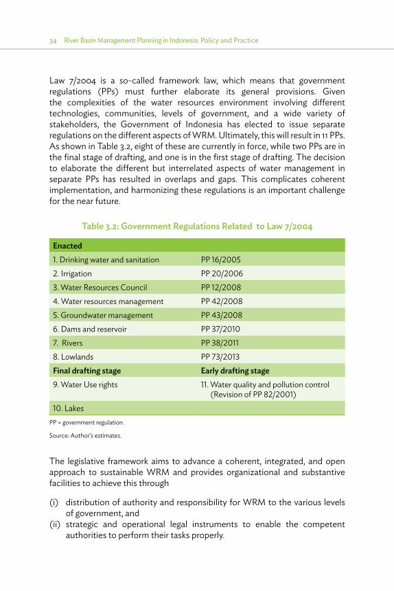
34 River Basin Management Planning in Indonesia: Policy and Practice
Law 7/2004 is a so-called framework law, which means that government regulations (PPs) must further elaborate its general provisions. Given the complexities of the water resources environment involving different technologies, communities, levels of government, and a wide variety of stakeholders, the Government of Indonesia has elected to issue separate regulations on the different aspects of WRM. Ultimately, this will result in 11 PPs. As shown in Table 3.2, eight of these are currently in force, while two PPs are in the final stage of drafting, and one is in the first stage of drafting. The decision to elaborate the different but interrelated aspects of water management in separate PPs has resulted in overlaps and gaps. This complicates coherent implementation, and harmonizing these regulations is an important challenge for the near future.
The legislative framework aims to advance a coherent, integrated, and open approach to sustainable WRM and provides organizational and substantive facilities to achieve this through
(i) distribution of authority and responsibility for WRM to the various levels of government, and
(ii) strategic and operational legal instruments to enable the competent authorities to perform their tasks properly.
Table 3.2: Government Regulations Related to Law 7/2004
Enacted 1. Drinking water and sanitation PP 16/20052. Irrigation PP 20/20063. Water Resources Council PP 12/20084. Water resources management PP 42/20085. Groundwater management PP 43/20086. Dams and reservoir PP 37/20107. Rivers PP 38/20118. Lowlands PP 73/2013Final drafting stage Early drafting stage9. Water Use rights 11. Water quality and pollution control
(Revision of PP 82/2001)10. Lakes
PP = government regulation.
Source: Author’s estimates.
Legal and Institutional Framework in Indonesia 35
3.2.3. Authority and ResponsibilityThe guiding principle of the law is the river basin approach, which is also applied to groundwater basins. Within the basins, a major activity is the development and operation of irrigation systems. Because administrative boundaries are seldom congruent with hydrological dimensions of river basins, and often also differ from the irrigation system boundaries, it is necessary to attribute responsibility for strategic and operational water management among the different governments involved.
3.2.3.1. River Basins
The law introduces RBTs for surface water (Wilayah Sungai or WS) and contains a chapter entitled “Authorities and Responsibilities” that addresses in general terms which government is responsible for which WS. The law distinguishes district, cross-district, cross-provincial, international, and national strategic WS.15 Based on these characteristics (criteria which are elaborated in more detail in PP 42/2008), the authorities and responsibilities are distributed as follows:
(i) Central government is responsible for international and national strategic WS, and for WS stretching into more than one province (cross-provincial basins).
(ii) Provinces are responsible for WS covering more than one district in their jurisdiction (cross-district basins).
(iii) Districts are responsible for WS entirely contained within their own jurisdiction.
According to the law, the instrument for determining WS16 is the Presidential Decree. An initial determination of WS was given in PerMen PU 11A/2006. Subsequently, Presidential Decree 12/2012 defined 131 WS, with the central government responsible for 63 WS, provinces for 53 WS, and districts for 15 WS. This is further elaborated on in Section 3.3.1.
15 Article 13 introduces the same system for groundwater basins, except the category “national-strategic interest.”
16 It is important to recognize the difference between a river basin territory (WS) and a river basin (Daerah Aliran Sungai or DAS). A DAS comprises the catchment of only one river and is defined based on natural hydrological boundaries. A WS is defined to address water resource management aspects and comprises one or more DAS.
36 River Basin Management Planning in Indonesia: Policy and Practice
3.2.3.2. Irrigation Systems
The law generally attributes authority and responsibility to irrigation systems on criteria similar to those for WS but also takes a functional aspect into consideration: Article 16 distinguishes between development and operation and maintenance (O&M), making development the responsibility of central government in primary and secondary international, national strategic, and cross-provincial irrigation systems. With regard to the so-called “national strategic irrigation systems,” the elucidation (but not the text) of Article 16 states that this term applies to systems larger than 10,000 hectares (ha).
More detailed provisions are contained in Articles 41, 64, and 78:
(i) Article 41 states that the central government is responsible for development of primary and secondary cross-provincial irrigation systems, provinces are responsible for cross-district irrigation systems, and districts are responsible for irrigation systems in a certain district.
(ii) Article 64 applies the same principles for the distribution of the responsibility for O&M.
(iii) Article 78 makes the same split for financing the irrigation systems.
During the parliamentary debate, attribution of responsibility for O&M was also made dependent on the size of the scheme. This is further elaborated on in PP 20/2006 on Irrigation:
(i) Central government is responsible for O&M of primary and secondary irrigation systems larger than 3,000 ha.
(ii) Provinces are responsible for systems between 1,000 ha and 3,000 ha.(iii) Districts are responsible for systems of up to 1,000 ha.
3.2.3.3. Groundwater Basins
The task distribution for groundwater basins is based on the same criteria as for WS, except that there are no national strategic groundwater basins.
From a practical perspective, groundwater basins cannot be managed physically in the same way as river basins: the focus of groundwater management is on regulating groundwater abstractions through licensing.
Other than in the case of surface water, the competence for groundwater licensing is fully decentralized: in all situations, the district head is the competent authority. However, the license should be based on the overall WRM plan. Furthermore, the district head must follow the technical recommendations of the province and/or the Ministry of Energy and Mineral Resources.
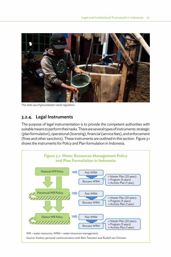
Legal and Institutional Framework in Indonesia 37
3.2.4. Legal InstrumentsThe purpose of legal instrumentation is to provide the competent authorities with suitable means to perform their tasks. There are several types of instruments: strategic (plan formulation), operational (licensing), financial (service fees), and enforcement (fines and other sanctions). These instruments are outlined in this section. Figure 3.1 shows the instruments for Policy and Plan formulation in Indonesia.
Figure 3.1: Water Resources Management Policy and Plan Formulation in Indonesia
° Master Plan (20 years)° Program (5 years)° Activity Plan (1 year)
° Master Plan (20 years)° Program (5 years)° Activity Plan (1 year)
National WR Policy
Provincial WR Policy
District WR Policy
Pola WRM
Pola WRM
Pola WRM
° Master Plan (20 years)° Program (5 years)° Activity Plan (1 year)Rencana WRM
Rencana WRM
Rencana WRM
WR = water resources, WRM = water resources management.Source: Author, personal communication with Bart Teeuwen and Rudolf van Ommen.
The wide use of groundwater needs regulation.
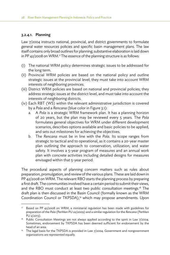
38 River Basin Management Planning in Indonesia: Policy and Practice
3.2.4.1. Planning
Law 7/2004 instructs national, provincial, and district governments to formulate general water resources policies and specific basin management plans. The law itself contains only broad outlines for planning; substantive elaboration is laid down in PP 42/2008 on WRM.17 The essence of the planning structure is as follows:
(i) The national WRM policy determines strategic issues to be addressed for the long term.
(ii) Provincial WRM policies are based on the national policy and outline strategic issues at the provincial level; they must take into account WRM interests of neighboring provinces.
(iii) District WRM policies are based on national and provincial policies; they address strategic issues at the district level, and must take into account the interests of neighboring districts.
(iv) Each RBT (WS) within the relevant administrative jurisdiction is covered by a Pola and a Rencana (blue color in Figure 3.1):a. A Pola is a strategic WRM framework plan. It has a planning horizon
of 20 years, but the plan may be reviewed every 5 years. The Pola formulates general objectives for WRM under different development scenarios, describes options available and basic policies to be applied, and sets out milestones for achieving the objectives.
b. The Rencana must be in line with the Pola. Its scope ranges from strategic to tactical and to operational, as it contains a 20-year master plan outlining the approach to conservation, utilization, and water safety. It involves a 5-year program of measures and an annual work plan with concrete activities including detailed designs for measures envisaged within that 5-year period.
The procedural aspects of planning concern matters such as rules about preparation, promulgation, and review of the various plans. These are laid down in PP 42/2008 on WRM. The relevant RBO starts the planning process by preparing a first draft. The communities involved have a certain period to submit their views, and the RBO must conduct at least two public consultation meetings.18 The draft plan is then discussed in the Basin Council (formally known as the WRM Coordination Council or TKPSDA),19 which may propose amendments. Upon
17 Based on PP 42/2008 on WRM, a ministerial regulation has been made with guidelines for preparation of the Pola (PerMen PU 22/2009) and a similar regulation for the Rencana (PerMen PU 2/2013).
18 Public Consultation Meetings are not always applied according to the spirit in Law 7/2004. Sometimes, endorsement by TKPSDA has been deemed sufficient for endorsement by the head of an area.
19 The legal basis for the TKPSDA is provided in Law 7/2004. Government and nongovernment organizations are represented equally.
Legal and Institutional Framework in Indonesia 39
completion of the planning process at the basin level, the TKPSDA Chair (usually the head of the regional planning board, BAPPEDA) submits the final draft for approval to the competent authority (i.e., the minister for national basins, the governor for provincial basins, and the district head for district basins).
3.2.4.2. Link with Spatial Management
Both Pola and Rencana have a strong relation with spatial plans, as stated already in Section 2.4.3. Both Water Resources Law 7/2004 and Spatial Planning Law 26/2007 prescribe a structured planning process at all levels of government, and each law contains specific references to the topics covered by the other. Table 3.3 indicates the similarities between the planning processes for both laws. Spatial plans indicate where urbanization takes place, and where demand will develop, which should be addressed through measures to be identified in the WRM plan. WRM plans indicate where facilities exist, or where they will be developed, and where space for this infrastructure should be reserved in the spatial plans. The WRM plans will also indicate where floods will occur, and the spatial plans should avoid new cities being planned at these locations without special precautions. The challenge now is to make this concept operational in the current Indonesian setting, looking for a balance between all the different interests in the present decentralized system of governance.
Table 3.3: Similarities between Planning for Water Resources and Spatial Management
Spatial management WR managementResponsibility/authority•�Central government •�Province•�Districts (cities/regencies)
Responsibility/authorityCentral government ProvinceDistricts (cities/regencies)
Coordination•� Provincial spatial management
coordination council•� District spatial management
coordination council
Coordination•�Provincial WR council•�District WR council•�Basin-level WRM coordination team
Substance•�Area structure plan•�Area spatial pattern plan•�Determination of strategic areas•�Reference for social utilization•�Reference for controlling utilization
Substance•�WRM Pola•�WRM Rencana
WR = water resources, WRM = water resources management.
Source: Author, personal communication with Bart Teeuwen and Rudolf van Ommen.

40 River Basin Management Planning in Indonesia: Policy and Practice
Law 26/2007 defines space as land, ocean, or air. Land-based water bodies are implicitly defined as part of land. Specifically, the law stipulates that 30% of RBTs should be covered by forest to preserve the environment (including land and water resources). Furthermore, the law stipulates that spatial utilization is to be carried out through developing the use of land, water, and airspace, together with the use of other natural resources. Accordingly, the Spatial Planning Law makes the WRM plan one of the inputs for preparation, review, and/or improvement of the regional spatial plan. Both the laws on water resources and spatial planning prescribe a structured planning process at all levels of the government, and each contains specific references to the topics covered by the other. This provides a ready framework for coordination.
There are obvious similarities between the frameworks for water resources and spatial planning. This spatial planning includes a national spatial plan, which informs the provincial spatial plan, which in turn informs the local government spatial plan. Lower-level plans must follow guidance of higher-level plans, and this is an opportunity for effective vertical coordination. At each level, the spatial plan comprises an outline of the spatial structure (residential centers and infrastructure network systems) and pattern (spatial allocation for conservation and development). These outlines are specified at the relevant scale and become more detailed as the plan level becomes lower. Finally, each level of government may designate “strategic areas” for which it can then assume total control of spatial management.
All levels of government share responsibility for managing spatial development based on criteria for externality, accountability, and efficiency.20 To achieve sustainable results, the externality perspective argues for strong guidance from higher-level government, for example, by setting boundaries for spatial utilization, while the efficiency perspective would place formulation and implementation of specific zoning regulations at the local level. By effectively coordinating these responsibilities, national and provincial governments can determine the relevance of natural river systems and water infrastructure for spatial management at the local level. For example, limitations could be proposed at the provincial level to development on riverbanks in flood-prone areas. Similarly, the coordination during spatial planning should identify vulnerable upper catchment conservation areas in the spatial pattern and thus create a legally enforceable limitation on development in such areas.
20 In accordance with PP 38/2007 on the distribution of tasks between the levels of government.

Legal and Institutional Framework in Indonesia 41
3.2.4.3. Licensing
Licensing as discussed here refers to activities within the scope of the Water Resources Law and as such involves activities in the water system. However, many development activities can have an impact on water resources even if they are not directly related to the water system. Such activities can be regulated by spatial planning, based on which (local) government issues, for example, location permits and other legal instruments such as building permits, land-use permits, etc.
Within WRM, licensing is used to regulate various types of water resources-related activities of individuals, groups, companies, such as water use (abstraction, disposal, power generation) and physical activities (construction activities, sand mining, etc.). The main principle of the Water Resources Law is that every activity needs a permit, except those related to social needs: water use for basic daily needs and for small-scale farmers in the existing irrigation systems. Furthermore, a permit should be based on the Pola or Rencana. The law addresses these principles only in general terms; specific government regulations further elaborate the different types of activities.
PP 42/2008 on WRM rather comprehensively regulates the licensing system. The arrangement pertains to construction activities, surface water use activities,21 and weather modification.22 Licensing of groundwater activities is regulated separately in PP 43/2008 on Groundwater Management. The licensing arrangement in PP 43/2008 pertains to commercial groundwater abstractions. It is a comprehensive arrangement that is separated from the WRM arrangement for surface water.
Apart from these basic provisions for licensing surface water and groundwater activities, more specific arrangements are provided in the different PPs governing the different subsectors of water management (PP 20/2006 on irrigation, PP 42/2008 on WRM, and PP 43/2008 on groundwater, etc.). The arrangements in the various regulations are not always consistent and show a degree of overlap, which is to be addressed by the anticipated harmonization of the PPs.
The vast majority of water use (surface water and groundwater) in Indonesia is for basic daily needs and small-scale irrigation in existing irrigation systems,
21 The license for groundwater use is not part of the license arrangement for surface water use. This is done in the PP on Groundwater Management (PP 43/2008).
22 The article stipulates that weather modification shall be regulated in a separate government regulation. For instance, it is applied in the generation of artificial rain.

42 River Basin Management Planning in Indonesia: Policy and Practice
and no license is required for this type of water use. All other types of water use (consumptive and commercial) need a license. However, Law 7/2004 provides only a single, undifferentiated approach for both simple and complex situations. With only limited capacity for processing all the licenses, this permit system proves difficult to implement in practice.
An alternative being contemplated at policy levels in the Government of Indonesia is to offer a differentiated licensing system, in which a simple, standard license with no special requirements would apply to small users, while large users must comply with stricter procedural requirements. Essential elements of a licensing system for large water users would involve public consultation and technical recommendations from relevant technical agencies.
3.2.4.4. Financing
Law 7/2004 contains a separate chapter that provides the main elements for financing WRM. An important part of this arrangement concerns payment for the use of water. The essence of the arrangement is that water as a commodity is free of charge, but that a “WRM fee” may be charged for services to bring the water from the source to the user. This fee is to be calculated so as to achieve cost recovery, and, in principle, applies for water for both basic daily needs and irrigation supply.23 Financing is further elaborated on in PP 42/2008 on WRM.
In practice, service fees for water services are applied only to bulk water supply and for drinking water. To date, there is no charge to cover the cost of providing water for irrigation and other types of water use, including flood management. Consequently, there is no independent source of funding for expansion or for building and sustaining reliable capacities and capabilities for WRM. In the absence of other ways to control the use of water as a scarce commodity, water pricing is required to check the inefficient use of water and spillage. Broadening the scope of the service fee is a sensitive political issue, but it is essential for adequate WRM as water utilization approaches the limits of available water resources.
3.2.4.5. Enforcement
A final category of legal instruments concerns enforcement. The competent authorities need suitable sanctions to deal with illegal activities in the water system (without license) or legal activities not implemented in accordance with the license conditions. The Water Law provides only criminal sanctions
23 However, the draft PP on water use rights states that this should be free of charge.

Legal and Institutional Framework in Indonesia 43
(penalties and fines) but does not mention administrative sanctions (such as written warnings, cease and desist orders, freezing the license, revocation of the license, and administrative fines). This omission has been mitigated in the various government regulations.
The advantage of administrative sanctions over criminal sanctions is that enforcement can take place more efficiently and effectively, because there is no need to involve the police and the public prosecutor. Moreover, criminal sanctions should be reserved for truly criminal activities. For most situations, administrative sanctions are more suitable.
3.3. Institutional Framework
3.3.1. Designated River Basin Management OrganizationsThe management setup of provincial WS is relatively straightforward. However, in interprovincial and national strategic WS, the situation is more complicated because there are both central and provincial RBOs operating in these WS.
The provincial organizations are the Balai PSDA (water resources management center at the provincial level), which have been established throughout Indonesia between 1995 and 2005. Besides creating a specific funding mechanism for O&M, Balai PSDA represents a significant improvement in basin management compared to the often dismal situation that was prevailing until then. However, the Balai PSDA were considered to lack sufficient capacity for fully integrated river basin management. In 2006, therefore, PU established RBOs under the Director General Water Resources [B(B)WS] for basins under central government, as indicated in Tables 3.4 and 3.5 (Java). Besides these two types of RBOs, there are also two national WRM corporations (PJT) and district agencies.
The B(B)WS was established based on PerMen PU 12/2006 and PerMen PU 23/2006. They are responsible for the main basin management functions: planning, WRM, and technical recommendations for licensing, O&M of water infrastructure, management of hydrological systems and water resources information system, and facilitating the activities of the TKPSDA.
Not all these tasks are being performed satisfactorily, as the organizations tend to focus on major projects and technical O&M. More strategic aspects of

44 River Basin Management Planning in Indonesia: Policy and Practice
Table 3.4: Overview of River Basin Organizations in Indonesia
CodeNumber
of WS B(B)WS BWS PJT
Provincial Balai PSDA Others
A1 (international)
5 a
A2 (interprovincial)
29 8 22a 1b 9
A3 (national strategic)
29 6 a 2 13
B (interdistrict) 53 36C (within one district)
15 15
Total 131 14 22 3 58 15Of which in Java 24 9 0 2 25
B(B)WS = Balai (Besar) Wilayah Sungai, PJT = Perum Jasa Tirta, PSDA = Pengelolaan Sumber Daya Air, WS = Wilayah Sungai.a One BWS manages several WS, mostly in one province. There are 22 BWS, and one BWS is present in each of the 33 provinces, except the six provinces of Java, Lampung, South Sumatra, South Sulawesi and West Sulawesi, where larger B(B)WS exist, and in Gorontalo.b WS Bengawan Solo is operated by PJT 1, originally established for Brantas. See also superscript b, Table 3.5.Source: Consultant estimate based on PerMen 12/2006, PerMen 23/2006 and WISMP-BWRM, and Inception Report TA 7799, confirmed by the Directorate General for Water Resources.
Table 3.5: Overview of River Basin Organizations in Java (situation November 2012)
CodeNumber
of WS B(B)WS BWS PJT
Provincial Balai PSDA Others
A1 (international)
0
A2 (interprovincial)
7 9a 0 1 12
A3 (national strategic)
4 b 0 2 3
B (interdistrict) 11 10C (within one district)
2 2
Total 24 9 0 3 25 2B(B)WS = Balai (Besar) Wilayah Sungai, PJT = Perum Jasa Tirta, PSDA = Pengelolaan Sumber Daya Air, WS = Wilaya Sungai.Notes:a One B(B)WS is working in two WS (B[B]WS Serayu–Opak).b Two WRM corporations: PJT 1 in WS Brantas and Bengawan Solo and PJT 2 in WS Citarum.Source: Java Water Resources Strategic Study (2011), updated after KepPres 12/2012.

Legal and Institutional Framework in Indonesia 45
IWRM, such as conservation and preservation, integrated planning, monitoring and evaluating of activities of all agencies in implementing WRM, liaising with agencies in other sectors that impact and depend on good-quality water resources, etc., remain underdeveloped. However, since 2012, much more attention has been given to these aspects.
O&M, even for national strategic basins, is mostly entrusted to provincial and local government WR agencies, but funded by PU through coadministration funds (TP-OP). In three basins, independent national WRM corporations (PJT 1 in WS Brantas and Bengawan Solo and PJT 2 in WS Citarum) operate the water resources infrastructure to provide bulk water supply. The PJTs levy a service fee and are allowed to use the revenue to fund their operational budgets directly. Thus, they do not depend on annual government budgeting.
All other aspects of water security are delegated to different agencies. Conservation of catchments is the responsibility of the district departments of Forestry and Agriculture, water quality is the responsibility of provincial and district agencies for Environment and Human Settlements, water distribution is the domain of public water supply companies at the district level, and mitigating the potential damage resulting from floods and drought as well as landslides is the responsibility of the provincial and district governments. A major regulatory instrument for implementation of water security objectives is spatial planning. This is the responsibility of the provincial and district planning boards (BAPPEDA).
3.3.2. Performance of River Basin OrganizationsA recent benchmark study24 of RBOs, comprising PJT, B(B)WS, and Balai PSDA, identified several key shortcomings of “regular” RBOs: lack of independent and direct funding for basin operation, lack of stakeholder involvement in basin operation, and lack of human resources management systems aimed at improving professional performance of WRM personnel. Conversely, the study showed that the PJTs stand out in terms of “river basin organization performance” and put more effort in involving stakeholders in operational WRM (this is especially true for PJT 1).
24 DHV & Associates. 2008. ADB TA No. 6351-REG Process Development for Preparing and Implementing IWRM Plans.

46 River Basin Management Planning in Indonesia: Policy and Practice
Box 3.1: Effective Water Resources Management in Indonesia
A good example of an effective water resources management organization in Indonesia is PJT 1, the public enterprise that is responsible for bulk water supply in the Brantas basin. PJT 1 receives income for its services and has been able to collect increasingly adequate revenues through effective communication with the stakeholders, by clearly linking fee increases to service improvements. Key aspects facilitating the superior performance of PJT 1 are(i) adequate budget based on cost recovery and revenues from users, independent
of fluctuating Government of Indonesia budgets and political favorites scenario;(ii) accountability to the users on how the funds are spent;(iii) good business management comprising adequate human resources management
with dependable and loyal staff groomed through independent career development and asset management focused on a life cycle approach with integrated planning for both investments and operation and maintenance; and
(iv) proactive role initiating overall basin plans, and coordination with other institutions to enhance performance in provision of water security.
Source: Author’s assessment based on RBO Benchmarking under ADB TA 6351 - REG. 2008.
But the superior performance of the PJTs is relative:
(i) They do not cover all aspects of basin management; they only have a limited brief to exploit water resources for a profit.
(ii) For PJT 2, the positive overall financial performance conceals a significant backlog in infrastructure maintenance. PJT 2 also is responsible for primary irrigation services that it must provide free of charge because the Government of Indonesia has designated irrigation a government responsibility. Full maintenance would impact negatively on its financial operating result.
(iii) Most of the other basins lack sufficient potential for revenue generation. While the PJTs derive most of their revenue from hydropower, and increasingly (see PJT 1) also from bulk water supply, the RBOs in the other basins deal mostly with irrigation. The fact that they cannot charge service fees for this severely limits their potential to be made into PJTs.
3.3.3. Organization of Stakeholder InvolvementIWRM is by nature a multisectoral activity involving many different interests. Law 7/2004 provides for a coordinating platform in the province (Dewan SDA, compulsory) and the RBTs (Basin Council or TKPSDA, optional). The Dewan is headed by the governor, and the TKPSDA by the head of the planning board (BAPPEDA). It is here that the involvement of stakeholders is organized,

Legal and Institutional Framework in Indonesia 47
both from the public and the private sector. These coordinating platforms are supposed to formulate policy and strategy, and it is in this role that they increasingly push for better service, aided by the fact that several government regulations now compel the competent authorities to provide a minimum service level. Moreover, stakeholders participating in the platforms are increasingly able and willing to pay for the services, as new investments require higher volumes and more reliable water supply and/or potential financial impacts of system failures for individuals as well as community are rising.
However, the Dewan and TKPSDA have no mandate to ensure that the result of their coordination is implemented. This is the responsibility of the regular government organizations, but there is no single organization with sufficient mandate and funds to provide overall coordination. Only the governor, in the dual role of head of province and representative of central government, can enforce coordination between provincial agencies and central government entities, such as B(B)WS, the BPDAS (under the Ministry of Forestry), and state enterprises such as the PJTs where they exist. While this provides an excellent opportunity for reference to the policy and strategies coordinated by the Dewan and TKPSDA, in many cases this is limited to operational concerns of the agencies involved.
Some experiences in setting up the TKPSDA for the WS around Jakarta (6 Cis area) have been presented in Section 6.3.2.
Engaging stakeholders in the river basin planning from the start.
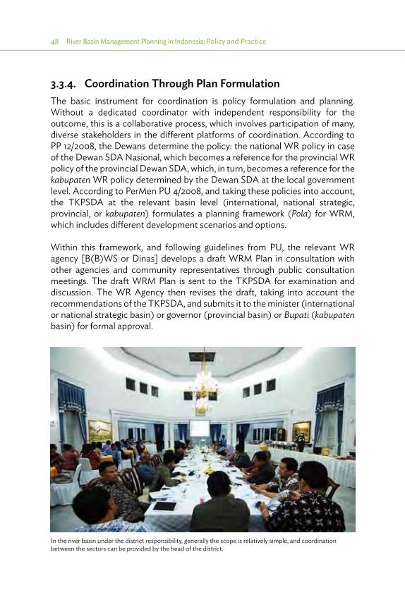
48 River Basin Management Planning in Indonesia: Policy and Practice
3.3.4. Coordination Through Plan FormulationThe basic instrument for coordination is policy formulation and planning. Without a dedicated coordinator with independent responsibility for the outcome, this is a collaborative process, which involves participation of many, diverse stakeholders in the different platforms of coordination. According to PP 12/2008, the Dewans determine the policy: the national WR policy in case of the Dewan SDA Nasional, which becomes a reference for the provincial WR policy of the provincial Dewan SDA, which, in turn, becomes a reference for the kabupaten WR policy determined by the Dewan SDA at the local government level. According to PerMen PU 4/2008, and taking these policies into account, the TKPSDA at the relevant basin level (international, national strategic, provincial, or kabupaten) formulates a planning framework (Pola) for WRM, which includes different development scenarios and options.
Within this framework, and following guidelines from PU, the relevant WR agency [B(B)WS or Dinas] develops a draft WRM Plan in consultation with other agencies and community representatives through public consultation meetings. The draft WRM Plan is sent to the TKPSDA for examination and discussion. The WR Agency then revises the draft, taking into account the recommendations of the TKPSDA, and submits it to the minister (international or national strategic basin) or governor (provincial basin) or Bupati (kabupaten basin) for formal approval.
In the river basin under the district responsibility, generally the scope is relatively simple, and coordination between the sectors can be provided by the head of the district.

Legal and Institutional Framework in Indonesia 49
The following sections describe the institutional setup for policy formulation and planning in the different types of basins.
3.3.4.1. Provincial Basins
In a provincial basin, the TKPSDA at the basin level (if established, not compulsory in Law 7/2004) formulates a water allocation plan and an operational management plan. Approval of these plans rests with the head of the provincial Water Resources Service (Dinas SDA). Basin plans must follow the outline provided in the provincial water resources policy formulated by the provincial Dewan SDA. This policy applies for the entire province, that is, for activities in all basins within the province.
The TKPSDA has a permanent secretariat provided by and part of the Balai PSDA, which in turn is part of the provincial Dinas SDA. The Dewan SDA also has a permanent secretariat provided by the provincial Dinas SDA (i.e., not from a Balai PSDA in one particular basin) (see Figure 3.2).
NGO = nongovernment organization, PSDA = Pengelolaan Sumber Daya Air - Water Resources Manage-ment, SDA = Water Resources, SKPD= Satuan Kerja Perangkat Daerah - Working Group in the district or province, TKPSDA = Tim Koordinasi Pengelolaan Sumber Daya Air, WRM = water resources management.
Source: 6 Cis Final Report.
Dinas SDAprovince
OtherSKPD NGOs
SecretariatDewan SDA
Dewan SDAprovince
Balai PSDAbasin
SecretariatTKPSDA
TKPSDAbasin
WRM Policyprovince
Water allocation plan basin
Other plansbasin
Governor
Operationalmgmt. planbasin
CommandParticipation
AuthorshipApproval
Policy guideline
Provincial Basin: Policy Formulation and Planning
Other SKPD NGOs
Prov
inci
al le
vel
Basin
leve
l
Figure 3.2: Provincial Basin: Policy Formulation and Planning

50 River Basin Management Planning in Indonesia: Policy and Practice
3.3.4.2. Interprovincial Basin
WRM is a central government responsibility toward basins that involves more than one province. To handle this, PU has set up B(B)WS in such basins since 2006. The head of B(B)WS reports to the Director General (DG) of water resources in the Ministry of Public Works (MPW).
Because its focus is the hydrological unit, that is, the basin, even in an interprovincial basin there is only one TKPSDA. However, since the basin comprises territories of more than one province, the plans that the TKPSDA formulates must not only provide plan inputs for the B(B)WS but also for the Balai PSDA in each province. Approval of the “partial” plans rests with Directorate General for Water Resources at MPW (DGWR) [for B(B)WS] and the Head Dinas SDA in each of the provinces (for Balai PSDA).
The “partial” basin plans must, of course, be in line with the water resources policy of the respective province. The provincial WR policy (Pola) is formulated by provincial Dewan SDA. It applies for activities in all basins within the respective province and is coordinated with the policy(ies) of the other province(s) involved in the basin. To ensure that a single operational plan for the basin does not have to deal with conflicting policies, the national Dewan SDA pays special attention to harmonization of the provincial policies, to the extent that they pertain to the interprovincial basin (please refer to Figure 3.3).
3.3.4.3. National Strategic Basin
Because it is by origin a provincial basin, the TKPSDA in the province formulates a water allocation plan and operational management plan. However, because the basin is of national strategic importance, approval of the plan does not rest with the head of the provincial Dinas SDA and in the end with the governor of that province, but with the head of the B(B)WS, the DG of Water Resources and eventually with the minister for public works (as the minister responsible for national water resources). Presumably, because the provincial Balai PSDA is responsible for many operational tasks, this approval will involve coordination with the head of the provincial Dinas SDA.
Basin plans must follow the outline provided in the water resources policy. Since it is a national strategic basin, the relevant policy is the national water resources policy, formulated by the national Dewan SDA as presented in KepPres 33/2011. Because local situations and conditions vary considerably, a single national policy cannot be sufficiently specific to provide guidance to all basin-level operation plans. Hence, representatives from provinces are invited
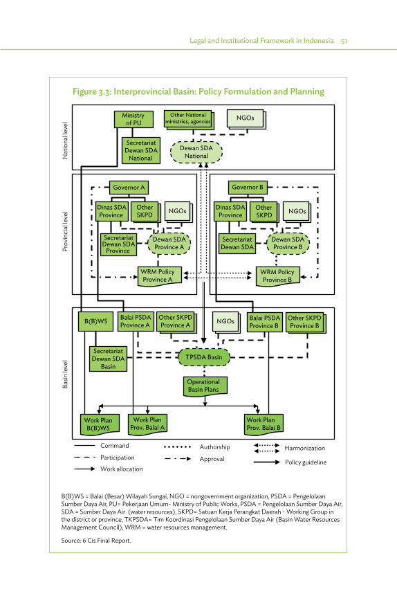
Legal and Institutional Framework in Indonesia 51
Ministry of PU
Interprovincial Basin: Policy Formulation and Planning
Other Nationalministries, agencies NGOs
SecretariatDewan SDA
National Dewan SDA
National
Governor A
Dinas SDAProvince
OtherSKPD
SecretariatDewan SDA
Province
WRM PolicyProvince A
Dewan SDAProvince A
B(B)WS Balai PSDAProvince A
Other SKPDProvince A
SecretariatDewan SDA
Basin
OperationalBasin Plans
Work PlanB(B)WS
Work PlanProv. Balai A
Work PlanProv. Balai B
Nat
iona
l leve
l
Governor B
Dinas SDAProvince
Other SKPD
SecretariatDewan SDA
WRM PolicyProvince B
Dewan SDAProvince B
NGOsNGOs
NGOs Balai PSDAProvince B
Other SKPDProvince B
TPSDA Basin
Prov
inci
al le
vel
Basin
leve
l
Command
Participation
Work allocation
Authorship
ApprovalHarmonization
Policy guideline
B(B)WS = Balai (Besar) Wilayah Sungai, NGO = nongovernment organization, PSDA = Pengelolaan Sumber Daya Air, PU= Pekerjaan Umum- Ministry of Public Works, PSDA = Pengelolaan Sumber Daya Air, SDA = Sumber Daya Air (water resources), SKPD= Satuan Kerja Perangkat Daerah - Working Group in the district or province, TKPSDA= Tim Koordinasi Pengelolaan Sumber Daya Air (Basin Water Resources Management Council), WRM = water resources management.
Source: 6 Cis Final Report.
Figure 3.3: Interprovincial Basin: Policy Formulation and Planning

52 River Basin Management Planning in Indonesia: Policy and Practice
to participate in deliberations when the national Dewan SDA has discussions on their basins. However, they do not become full-fledged members of the national Dewan SDA (See Figure 3.4).
Ministry of PU Other Nationalministries, agencies
Dewan SDANational
WRM PolicyNational
Dinas SDA Other SKPD NGOs
OperationalBasin Plans
Work PlanB(B)WS
CommandParticipationWork allocation
AuthorshipApproval Participation as observer
Policy guideline
SecretariatTPSDA
B(B)WS
Work PlanProv. Balai
Balai PSDAProvince
NGOs
SecretariatDewan SDA
TKPSDA Basin
Nat
iona
l leve
lBa
sin le
vel
National Strategic Basin: Policy Formulation and Planning
B(B)WS = Balai (Besar) Wilayah Sungai, NGO = nongovernment organization, PSDA = Pengelolaan Sumber Daya Air, PU= Pekerjaan Umum- Ministry of Public Works, SDA = Sumber Daya Air (water resources), SKPD= Satuan Kerja Perangkat Daerah - Working Group in the district or province, TKPSDA= Tim Koordinasi Pengelolaan Sumber Daya Air (Basin Water Resources Management Council), WRM = Water Resources Management.
Source: 6 Cis Final Report.
3.3.4.4. Link with Spatial Management
As is the case of Law 7/2004 on water resources, Law 26/2007 on spatial planning emphasizes the need for horizontal coordination between different sectors (internal coordination) and different jurisdictions (external coordination) at a given level of government. However, the laws do not describe how or by whom this coordination is to be achieved. This gap is filled by Regulation 50/2009 of the Minister of Home Affairs on coordination in spatial management, which instructs the governor and bupati/walikota to establish Regional Spatial Management Coordination Boards (BKPRD) at their respective levels.
Figure 3.4: National Strategic Basin: Policy Formulation and Planning

Legal and Institutional Framework in Indonesia 53
Coordination as intended to be implemented through the BKPRD in Ministry of Home Affairs (MOHA) Regulation 50/2009 is potentially very strong, as it becomes the direct responsibility of the governor, bupati or walikota and gives day-to-day responsibility to the provincial, regional, and municipal secretary (chair) and the head of BAPPEDA (secretary of the board). The regulation furthermore instructs the governor and bupati or walikota to instruct the directors of the relevant sectoral agencies to follow up on the recommendations of the BKPRD. The tasks of the BKPRD at the provincial and the local levels are similar, with specific attention on coordination between the two levels toward synergizing their respective spatial management plans. Furthermore, the provincial BKPRD is tasked with recommending solutions for spatial utilization issues that could not be resolved at the local level, and evaluating the performance of local-level spatial management plans.
Despite the focus on resolving issues between the provincial- and the local-level spatial plans, the terminology used to describe the task of the Regional Spatial Management Coordination Board (BKPRD) infers, perhaps unintentionally, a focus on horizontal coordination between development sectors and between neighboring districts (kabupatens). Vertical coordination between RBT-level water interests and spatial plans at district level is indirect at best, apparently flowing through alignment of the basin WRM Plan and the provincial Spatial Plan (at a relatively high level of abstraction) to guide local-level spatial management planning. The effectiveness of this approach would depend on the commitment of the provincial Dinas SDA (as member of the BKPRD) to safeguard the proper translation of the provincial-level conditions into the local-level zoning regulation. However, given the very limited role of Dinas SDA in basin management [executing O&M at the behest of the B(B)WS], it is not certain that this commitment will automatically arise or that the capacity for asserting it will even be available. In this setting, much, if not all, will depend on the personal understanding and commitment of the head of the provincial Dinas SDA.
3.4. Assessment of Existing Capacity
3.4.1. Capacity for Water Resources ManagementAccording to Law 7/2004, the central government should provide services for all aspects of WRM in the RBTs (WS) under its responsibility. This comprises the natural systems of rivers and lakes, as well as initial development of facilities and subsequent sustainable management of these facilities. With this in mind, the MPW established the B(B)WS.

54 River Basin Management Planning in Indonesia: Policy and Practice
Provinces and districts should provide these services in the WS under their responsibility. However, the central government is still responsible for maintaining an overall minimum standard of WRM services. These minimum standards are not (yet) clearly described.
In practice, the responsibilities for WRM are more diverse. Because of limitations in its personnel, the day-to-day management of most facilities in all WS is delegated to provincial and district personnel, as far as available at that level. The central government only considers overall basin management and development (or rehabilitation) of major facilities in its “own” basins through B(B)WS, and in other basins directly from the MPW if requested by provinces or districts, based on their overall responsibility for minimum standards. In general, this “fuzzy” division of responsibilities works reasonably well, although in case of emergencies sometimes there is ambiguity as to who is responsible for mitigation.
3.4.2. Capacity for Basin Water Resources Management Planning
Law 7/2004 specifies that basin WRM planning in each WS should be provided by the government responsible in that WS. As indicated in Section 2.6, progress in formulation of Pola for central government WS is more advanced than for those under provincial responsibility, and progress is not clear for all district WS. This is mainly related to available expertise and financial resources. The central government has both, and most provinces are also capable of mobilizing sufficient expertise and resources. But the districts are found wanting in this regard.
Expertise is mostly provided from outside the responsible RBO. An essential input is given by the Water Resources Research and Development Agency (PusAir), especially concerning provision of hydrological data and application of analyzing tools. Most Pola and Rencana are formulated with assistance from consultants, either through firms or individual consultants. B(B)WS/BWS or Dinas/Balai PSDA usually only supervise the formulation. In this way, the financial arrangements have significant influence.
3.5. Financial Arrangements
3.5.1. Financing Water Resources ManagementAccording to Law 7/2004, WRM financing is to cover all real needs of managing water resources, covering both development (preliminary investigations,
Legal and Institutional Framework in Indonesia 55
planning, design, and construction) and sustainable O&M of infrastructure, including all costs associated with general management as well as regular rehabilitation. The different activities may be funded by government or private sector sources and by WRM service fee. The government would fund public water infrastructure, including most parts of the irrigation systems, while private funding would come into play for utilization of water resources by private parties. An in-between category may be funding from corporate social responsibility budgets, but this is not really significant in general terms.
The law creates the possibility to institute a WRM service fee, and this is further regulated in PP 42/2008 on WRM. This PP stipulates that the service fee should cover costs including those for depreciation, amortization and interest, O&M, and water resources development, thus clearly indicating an intention to achieve full cost recovery. However, the only location where such fees are applied for a limited amount of users (power generation, public water supply companies, and some other bulk users) is in the WS with water management authorities (PJT 1 in Brantas and Bengawan Solo, and PJT 2 in WS Citarum). To date, there have been no serious attempts to introduce the fee effectively in other areas. Where such fees are collected, the law provides that the basin management organization may directly use the income derived from this for execution of its WRM tasks. This makes the WRM service fee potentially very effective for further development of WRM in Indonesia.
In WS that are the responsibility of the central government, administrated by the MPW through the B(B)WS, funding WRM is relatively straightforward: the central government pays for all public infrastructure specified in Law 7/2004 and its related O&M. This is decided at the central level in accordance with national priorities and is based on the needs communicated by the B(B)WS in the basins. However, as mentioned in Section 3.4, the B(B)WS has very limited operational field-level capacity for O&M. Therefore, it delegates O&M to provincial and district water resources agencies, which receive the associated budget in the form of coadministration funds. As a result, the B(B)WS is mainly involved in development activities, and hardly in day-to-day management. Moreover, this also results in less attention to identification of minor shortcomings, which need immediate repair to avoid escalation into major failures. Another impact is that most attention is given to development activities, where large budgets are available, and less to planning and monitoring with limited budgets.
In provincial- and district-level WS, the responsibilities for funding are no different, but the implementation is. In these basins, the central government is not responsible for day-to-day management and thus does not avail of all the necessary information to feed into its planning and budgeting process. The
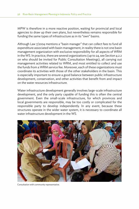
56 River Basin Management Planning in Indonesia: Policy and Practice
MPW is therefore in a more reactive position, waiting for provincial and local agencies to draw up their own plans, but nevertheless remains responsible for funding the same types of infrastructure as in its “own” basins.
Although Law 7/2004 mentions a “basin manager” that can collect fees to fund all expenditure associated with basin management, in reality there is not one basin management organization with exclusive responsibility for all aspects of WRM in the WS. In practice, there are several organizations (up to 24, see Section 4.2.2 on who should be invited for Public Consultation Meetings), all carrying out management activities related to WRM, and most entitled to collect and use the funds from a WRM service fee. Moreover, each of these organizations must coordinate its activities with those of the other stakeholders in the basin. This is especially important to ensure a good balance between public infrastructure development, conservation, and other activities that benefit from and impact on the water resources infrastructure.
Water infrastructure development generally involves large-scale infrastructure development, and the only party capable of funding this is often the central government. Even the small-scale infrastructure, for which provinces and local governments are responsible, may be too costly or complicated for the responsible party to develop independently. In any event, because these structures operate in the wider water system, it is necessary to coordinate all water infrastructure development in the WS.
Consultation with community representative.
Legal and Institutional Framework in Indonesia 57
In WS under district responsibility, the scope of operations is relatively simple, and coordination between the sectors can be provided by the head of the district. Also, this is the case in most provincial WS, since the governor is usually in close contact with the district heads in the province. But coordination gets complicated in the WS with central government responsibility, because the governors and district heads with coordinating power are not automatically involved. For the provincial- and district-level WS, the nonavailability of financial resources is usually the limiting factor.
3.5.2. Water Resources Management Budget Allocation3.5.2.1. Principles
Achieving the objectives of the basin plans requires a series of annual work plans (AWPs) over many years. This makes it important that the successive annual budgets are based on the basin plan and take into account progress already achieved. The annual budget preparation process is regulated in PP 8/2008 on budget preparation and Permendagri 59/2007 (MOHA).
3.5.2.2. Musrenbang Methodology
Budget preparation in the district- and provincial-level agencies takes place through the Musrenbang (Musyawarah perencanaan pengembangan or “consensus in development planning”) process, in which the aspirations, preferences, and priorities of the communities are recorded. The process starts at the desa (village) level, continues through kecamatan (subdistrict), district, and provincial levels, and culminates in the national Musrenbang. The agencies participating in the process present their draft AWPs as inputs for the process, and in the end adjust these AWPs after receiving the budget ceilings resulting from the national Musrenbang (Figure 3.5).
The Musrenbang process originates from the desire to achieve local priorities with local capacities. Hence, it starts with generating community-supported activities. These usually involve a combination of time and land provided by the community, and some external resources (cement, steel, heavy equipment, etc.) provided by government agencies. As proposals are collected, adjustments take place to select only the highest priorities and arrive at a realistic budget. The local government indicates how much it can contribute. The Musrenbang process thus creates a commitment between the community and the local government.
However, when the investments are larger or serving a wider goal, such as investments in conservation with benefits in terms of fewer floods, higher dry season flows, less maintenance for silt removal, etc., it may not be possible for the
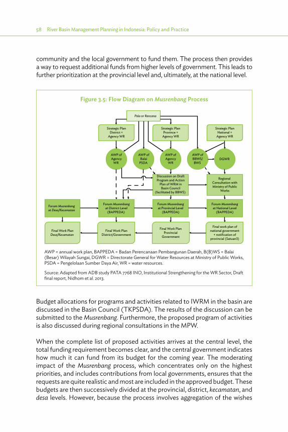
58 River Basin Management Planning in Indonesia: Policy and Practice
community and the local government to fund them. The process then provides a way to request additional funds from higher levels of government. This leads to further prioritization at the provincial level and, ultimately, at the national level.
Figure 3.5: Flow Diagram on Musrenbang Process
Strategic PlanDistrict +
Agency WR
Strategic PlanProvince +
Agency WR
Strategic PlanNational +
Agency WR
AWP ofAgency
WR
AWP ofBalai
PSDA
AWP ofAgency
WR
AWP ofBBWS/BWS
DGWR
Pola or Rencana
Discussion on DraftProgram and Action
Plan of WRM inBasin Council
(facilitated by BBWS)
Regional Consultation withMinistry of Public
Works
Forum Musrenbangat Desa/Kecamatan
Forum Musrenbangat District Level
(BAPPEDA)
Forum Musrenbangat Provincial Level
(BAPPEDA)
Forum Musrenbangat National Level
(BAPPEDA)
Final Work PlanDesa/Kecamatan
Final Work PlanDistrict/Government
Final Work PlanProvincial
Government
Final work plan ofnational government
+ notification ofprovincial (Satuan3)
AWP = annual work plan, BAPPEDA = Badan Perencanaan Pembangunan Daerah, B(B)WS = Balai (Besar) Wilayah Sungai, DGWR = Directorate General for Water Resources at Ministry of Public Works, PSDA = Pengelolaan Sumber Daya Air, WR = water resources.
Source: Adapted from ADB study PATA 7768 INO, Institutional Strengthening for the WR Sector, Draft final report, Nidhom et al. 2013.
Budget allocations for programs and activities related to IWRM in the basin are discussed in the Basin Council (TKPSDA). The results of the discussion can be submitted to the Musrenbang. Furthermore, the proposed program of activities is also discussed during regional consultations in the MPW.
When the complete list of proposed activities arrives at the central level, the total funding requirement becomes clear, and the central government indicates how much it can fund from its budget for the coming year. The moderating impact of the Musrenbang process, which concentrates only on the highest priorities, and includes contributions from local governments, ensures that the requests are quite realistic and most are included in the approved budget. These budgets are then successively divided at the provincial, district, kecamatan, and desa levels. However, because the process involves aggregation of the wishes
Legal and Institutional Framework in Indonesia 59
and aspirations from the lower levels influenced by preferences and priorities of institutions at these higher levels, and because the same occurs when the planned budget is divided on the way down the chain, there is no guarantee that the originally stated wishes would be included in the budget that finally becomes available at the local level.
3.5.2.3. Budgets for Basin Development
Ideally, the proposed AWPs are based on the strategic plans formulated for the basin, that is, the Rencana. Each district and province has a strategic medium-term plan (RPJM), and each agency has a strategic plan (RENSTRA). It is assumed that the RPJM and RENSTRA include the objectives of the Rencana, or, if the Rencana is of a later date, the Rencana includes the RPJM and RENSTRAs.
However, numerous observations suggest that, in most cases, the Rencana is not yet used as a guidance for annual work planning and annual budget allocation (DIPA). Possible reasons for this are as follows:
(i) The Rencana is not yet official.(ii) The DIPAs of institutions other than B(B)WS are not shown.(iii) There is no mechanism to enhance the use of the Rencana as guidance for
DIPA formulation in the B(B)WS and other institutions.(iv) Other institutions, most notably in the districts, do not know how to access
additional funding for implementation of Rencana activities.
Rencana not yet official: If the Rencana is not yet endorsed by the TKPSDA and the Minister of Public Works, the B(B)WS cannot use it as a reference to support related budget requests in DGWR. It is assumed that this issue will be addressed after all basins have an official Rencana in 2015.
More than one institution involved: There may be some extra Rencana activities included in the DIPA of other institutions. For example, the districts may have activities concerning conservation such as reforestation, but the scale of the activities is much below the scale proposed in the Rencana (based on the analysis of the Balai PDAS by the Ministry of Forestry). Reasons could be that the Rencana is not official yet, the district agency is not aware of the agreed Rencana activities, socialization is insufficient, or the district agency is not using the Rencana as guidance for DIPA allocations.
The B(B)WS, as initiator and the main institution responsible for IWRM, should be the main custodian of the Basin Plans, and should proactively stimulate and support the relevant institutions to take up their role in implementing the activities agreed in the Rencana. Also, the TKPSDA has an important role in this. There is an urgent need to monitor and evaluate the DIPA of B(B)WS and other institutions involved in the proposed Rencana activities.

60 River Basin Management Planning in Indonesia: Policy and Practice
No mechanism to enhance use of Rencana for DIPA allocation: Budget allocation is supposed to start with the Musrenbang process and the proposed Rencana activities are supposed to be in accordance with the preferences and priorities of the institutions involved. However, budgets are limited and each year priorities shift, and therefore there is no guarantee that the institutions will include the required budgets for implementation of the Rencana. A dedicated unit for monitoring and evaluation (M&E) of the proposals and possible budgets in the Musrenbang process could help resolve this issue. This is further elaborated on below.
Many institutions do not know how to obtain more budget: There are generic funds available at the central level for assistance in specific programs. One of these subjects is conservation, in connection with which the Gerakan Nasional Konservasi dan Pengelolaan Air is provided with huge budgets for reforestation, gully plugs, terracing, etc. Additional funding may also be available from other government organizations (such as PJT 2), and private corporations have budgets for conservation as part of their corporate social responsibility programs. However, many of the districts, which are responsible for implementation of most conservation programs, do not know how they could access these budgets, or coordinate their activities and funding with the institutions supervising conservation in their jurisdiction (such as BPDAS). A dedicated unit for M&E could have a contributing role in this as well.
3.5.2.4. Monitoring and Evaluation of All Budgets of All IWRM Institutions
A dedicated unit for M&E of the proposals and related budgets for activities in the Rencana would considerably strengthen the effectiveness of the Musrenbang process for WRM. This unit could also assist the districts in obtaining access to funding from the central level or in proposing activities that are complementary to those typically funded from these central-level budgets in the relevant districts. The TKPSDA has an interest in these budgets being spent effectively in the basin and could have a role in assisting, endorsing, and supervising the activities of the units.
The M&E unit could be placed in the B(B)WS, possibly in the secretariat of the TKPSDA, which would also enhance the involvement of the TKPSDA. This would create a dualism that facilitates transparent and easier monitoring by the TKPSDA and other interested parties. A major factor for success is strong support from the head of B(B)WS, both in providing adequate personnel and budget for the unit. Without this support, the unit will find it difficult to establish its significance. In addition, there has to be close cooperation with the relevant BAPPEDAs and the activities should be under supervision of the TKPSDA.
4 Basin Planning Required in Indonesia
4.1. Introduction
As indicated in Chapter 3, Law 7/2004 defines basin planning as formulating the outline to realize long-term objectives for Integrated Water Resources Management (IWRM) in specific basins, with a time frame of 20 years, to be reviewed every 5 years. The law differentiates between a strategic management plan (Pola) and a Basin Water Resources Management Planning (BWRMP) (or Rencana):
(i) A Pola is a strategic framework plan for the outline to realize long-term objectives (20-year time horizon) for IWRM in the specific basin territory (Wilayah Sungai or WS). The Pola contains policy statements regarding general objectives and the direction of water resources management (WRM) in the WS, main principles to be used, priorities and milestones for achieving the general objectives, and basic policies to be applied.
(ii) The Rencana for the WS must be in accordance with the Pola and has a strategic, tactical, and operational character. It contains a long-term dimension (Master Plan for 20 years) and a medium-term dimension (Program for 5 years), including basic designs and prefeasibility assessments. This will be followed by feasibility studies, detailed designs, and implementation plans. The short-term dimension (1 year) is covered in the annual work plans (AWPs).
In principle, the Pola formulates the principles for the strategic plan, with several strategic options (main strategies, each listed in a matrix for different scenarios), and the Rencana completes the strategic plan (selecting a main strategy for a specific scenario) and continues with the tactical and operational aspects of the Basin Water Resources Management Master Plan. The main result of the Pola is the matrix for operational policies, which comprises 3–5 matrices (one for each main strategy), each with a detailed overview of the various aspects of WRM (such as conservation, utilization, disaster etc., each with various subaspects such as erosion, water retention, water quality etc., for the aspect of conservation) identified, and for each aspect:

62 River Basin Management Planning in Indonesia: Policy and Practice
(i) targets to improve the situation;(ii) a list of measures (such as regulation, reforestation, dams, canals, etc.), to
achieve these targets in the short (<5 years), medium (<10 years), and long term (<20 years); and
(iii) specific steps to be taken (called operational policies) and identifying which institution is responsible and which other institutions are involved.
The Rencana process takes this further. It starts with selecting a main strategy (which is basically selecting the scenario with the related targets, leaving out the other main strategies of the Pola with too high or too low targets). It continues with providing a basic design and feasibility assessment for selected measures (which allows selection of different options to achieve the targets), and formulating the matrix for programs and activities. The matrix in the Rencana builds further on the matrix for operational policies of the Pola, continuing only with the measures identified in the Pola for the selected main strategy for each aspect, and further reviewed and developed during the Rencana process. The matrix in the Rencana specifies for each aspect and subaspect:
(i) the proposed measures (nonphysical and physical);(ii) location (district or city);(iii) type of work (regulation, policy, study, construction, etc.);(iv) volume;(v) outcome;(vi) cost;(vii) the criteria for meeting economic, environmental, and social feasibility;(viii) timing; and(ix) which institution is responsible and which other institutions are involved.
Both the Pola and Rencana should address the main topics for IWRM as indicated in Law 7/2004, as follows:
(i) conservation (upper catchments, water quality—Konservasi SDA);(ii) utilization of water resources (Pendayagunaan SDA);(iii) mitigation of floods and droughts (Daya Rusak Air);(iv) data and information systems; and(v) community participation (Partisipasi Masyarakat), including institutional
strengthening.
To these five aspects, we have added a sixth, current spatial planning.
The relationship between the main topics is shown in Figure 4.1.
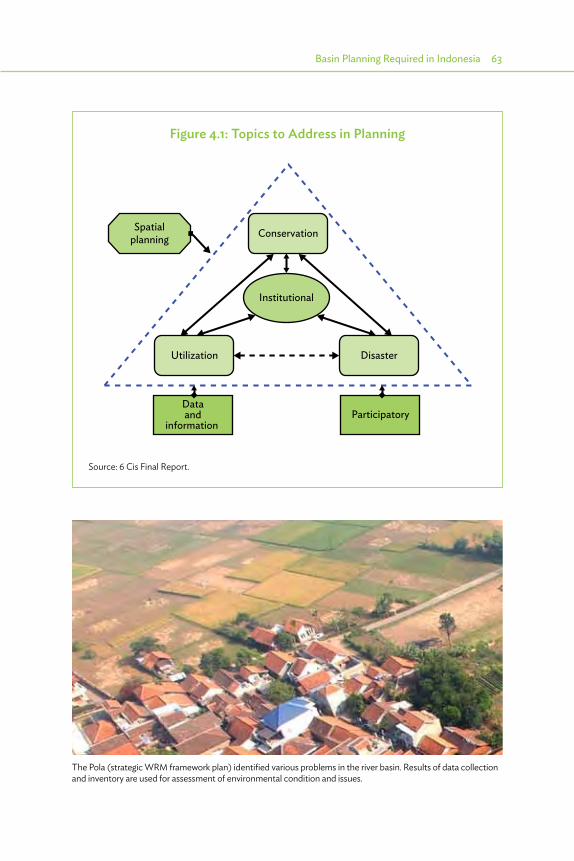
Basin Planning Required in Indonesia 63
Figure 4.1: Topics to Address in Planning
Conservation
Utilization Disaster
Spatialplanning
Institutional
Dataand
information Participatory
Source: 6 Cis Final Report.
The Pola (strategic WRM framework plan) identified various problems in the river basin. Results of data collection and inventory are used for assessment of environmental condition and issues.
64 River Basin Management Planning in Indonesia: Policy and Practice
Guidelines for the Pola and Rencana have been provided in PP 42/2008 and further detailed in the ministerial regulation from the Minister of Public Works: PerMen PU 22/2009 for the Pola and PerMen PU 2/103 for the Rencana. In principle, strategic planning is a process to develop a set of measures (strategies) to meet one or more specific, measurable goals over a long time frame. The Rencana is further working out the Pola in more detailed plans and further selection of measures, based on basic designs and preliminary feasibility assessments. This is worked out in detail in Sections 4.2 and 4.3.
The Ministry of Public Works (MPW), which is responsible for WRM, is assigned the task of preparing these plans. Triggered by Law 7/2004, the MPW established in 2006 the B(B)WS under the responsibility of the Directorate General for Water Resources at Ministry of Public Works (DGWR) and entrusted it with WRM, including preparation of Pola and Rencana, in river basin territories under the responsibility of the Government of Indonesia. For basins under provincial authority, the Provincial Water Resources Services (PWRS) is responsible for formulating the Basin Plans, and for those under district authority, the District Water Resources Services is responsible.
The technical team and the Basin Council (or the coordination team for water resources management—TKPSDA) play an important role during the plan formulation process. The technical team comprises senior water resources specialists from among present or former DGWR staff and is called for meetings to review the proposed Pola and Rencana. The Basin Council has already been described in Section 2.8.
4.2. Pola
4.2.1. IntroductionThe guidelines for strategic planning for IWRM, the Pola, are provided in the ministerial regulation PerMen PU 22/2009. The Pola should provide (Article 3) the following official objects.
(i) Objective and basic considerations concerning WRM in the basin, which comprises long-term objectives and an assessment of present conditions and issues.
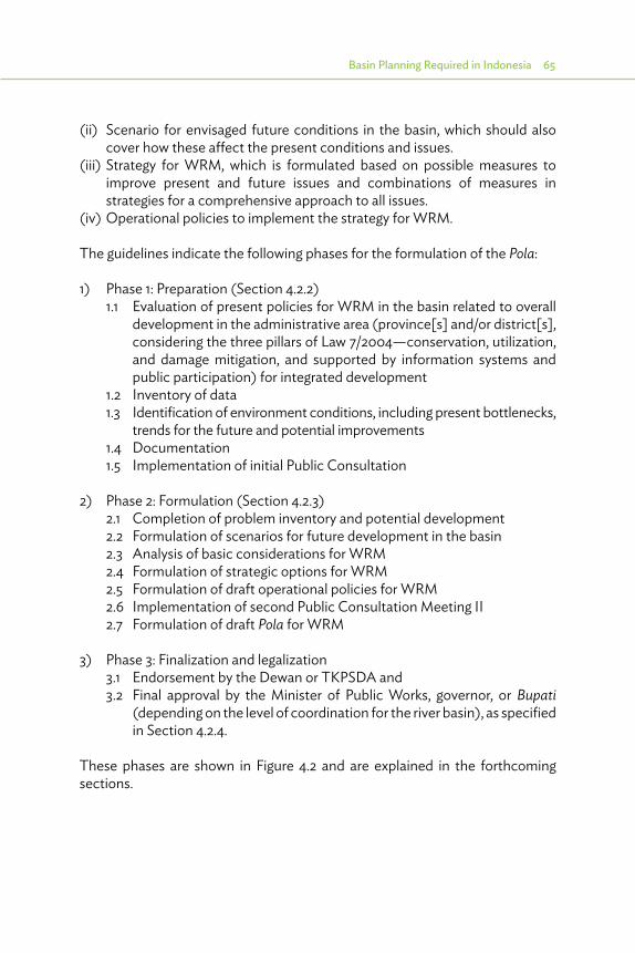
Basin Planning Required in Indonesia 65
(ii) Scenario for envisaged future conditions in the basin, which should also cover how these affect the present conditions and issues.
(iii) Strategy for WRM, which is formulated based on possible measures to improve present and future issues and combinations of measures in strategies for a comprehensive approach to all issues.
(iv) Operational policies to implement the strategy for WRM.
The guidelines indicate the following phases for the formulation of the Pola:
1) Phase 1: Preparation (Section 4.2.2)1.1 Evaluation of present policies for WRM in the basin related to overall
development in the administrative area (province[s] and/or district[s], considering the three pillars of Law 7/2004—conservation, utilization, and damage mitigation, and supported by information systems and public participation) for integrated development
1.2 Inventory of data1.3 Identification of environment conditions, including present bottlenecks,
trends for the future and potential improvements1.4 Documentation 1.5 Implementation of initial Public Consultation
2) Phase 2: Formulation (Section 4.2.3)2.1 Completion of problem inventory and potential development2.2 Formulation of scenarios for future development in the basin2.3 Analysis of basic considerations for WRM2.4 Formulation of strategic options for WRM2.5 Formulation of draft operational policies for WRM2.6 Implementation of second Public Consultation Meeting II2.7 Formulation of draft Pola for WRM
3) Phase 3: Finalization and legalization3.1 Endorsement by the Dewan or TKPSDA and 3.2 Final approval by the Minister of Public Works, governor, or Bupati
(depending on the level of coordination for the river basin), as specified in Section 4.2.4.
These phases are shown in Figure 4.2 and are explained in the forthcoming sections.

66 River Basin Management Planning in Indonesia: Policy and Practice
Figure 4.2: Process for Pola Formulation
Study current policies forWRM in WS
Data inventarization Identification of environmentalcondition and policies
Documentation of general condition
PHASE 1Preparation
PKM I
Completion of problemdefinition and possible
WR development
Analysis Scenario
Completion of problemdefinition and possible
WR development
PKM I
Completion of draft Pola
PHASE 2Formulation
Finalization in Basin Council
Legalization by ministry,governor, or Regent
Pola forWRM
PHASE 3Finalization
PKM = public consultation meeting, WR = water resources, WRM = water resources management, WS = Wilayah Sungai.
Source: PerMen (Ministerial Regulation). 2009.

Basin Planning Required in Indonesia 67
4.2.2. Phase 1: PreparationThe process starts with inventory and evaluation of Step 1.1 Present policies concerning WRM at the national and provincial levels, and possibly the district level. Aspects to be considered are environment, forest, local government, disasters, spatial planning, coastal development, surface water, and groundwater. Strategic aspects are also the Millennium Development Goals (MDGs), food security, global change, and availability of energy. The aim is to assess the various targets set, the proposed direction and concrete steps for development, and the possible bottlenecks for integrated WRM development. The results of this activity are:
(i) identifying a list of problems, and(ii) formulating possible strategies to address these problems (solving,
mitigation, or any other type of strategy).
The process continues with Step 1.2 Data collection and inventory. Data to be collected should usually cover data describing present conditions, frequently based on historic data, but also identified trends or assumed development of these data in the future are required. These data need to be quantitative as far as possible, but can be qualitative, indicating the strengths and weaknesses of the current situation. Types of data are given in Box 4.1. Direction should be provided by the list of problems and strategies identified in Step 1.1.
Public consultation meeting 1 (PKM 1) aims to assess the aspirations of the stakeholders.
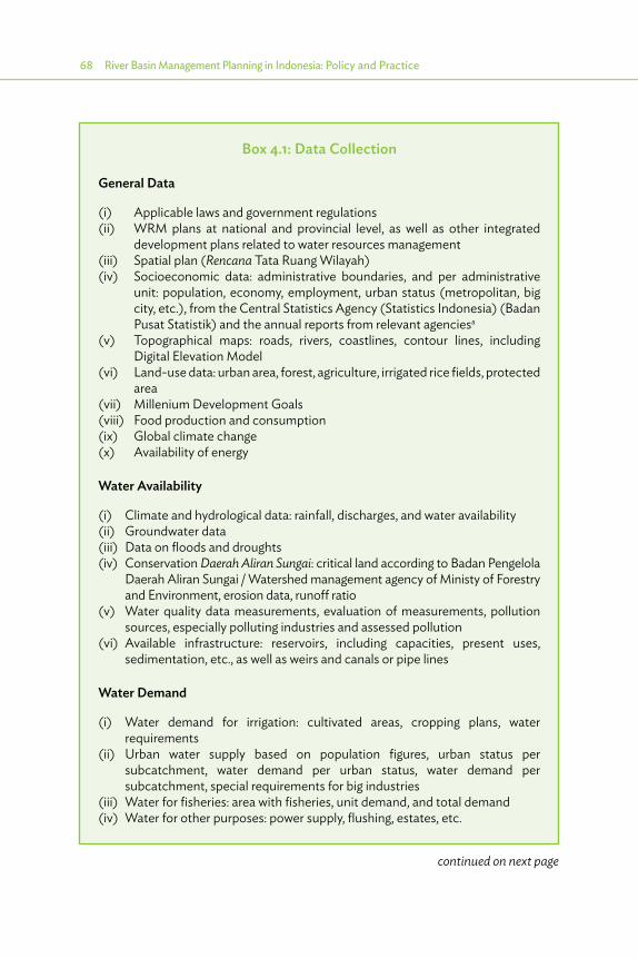
68 River Basin Management Planning in Indonesia: Policy and Practice
Box 4.1: Data Collection
General Data
(i) Applicable laws and government regulations(ii) WRM plans at national and provincial level, as well as other integrated
development plans related to water resources management(iii) Spatial plan (Rencana Tata Ruang Wilayah)(iv) Socioeconomic data: administrative boundaries, and per administrative
unit: population, economy, employment, urban status (metropolitan, big city, etc.), from the Central Statistics Agency (Statistics Indonesia) (Badan Pusat Statistik) and the annual reports from relevant agenciesa
(v) Topographical maps: roads, rivers, coastlines, contour lines, including Digital Elevation Model
(vi) Land-use data: urban area, forest, agriculture, irrigated rice fields, protected area
(vii) Millenium Development Goals(viii) Food production and consumption(ix) Global climate change(x) Availability of energy
Water Availability
(i) Climate and hydrological data: rainfall, discharges, and water availability(ii) Groundwater data(iii) Data on floods and droughts(iv) Conservation Daerah Aliran Sungai: critical land according to Badan Pengelola
Daerah Aliran Sungai / Watershed management agency of Ministy of Forestry and Environment, erosion data, runoff ratio
(v) Water quality data measurements, evaluation of measurements, pollution sources, especially polluting industries and assessed pollution
(vi) Available infrastructure: reservoirs, including capacities, present uses, sedimentation, etc., as well as weirs and canals or pipe lines
Water Demand
(i) Water demand for irrigation: cultivated areas, cropping plans, water requirements
(ii) Urban water supply based on population figures, urban status per subcatchment, water demand per urban status, water demand per subcatchment, special requirements for big industries
(iii) Water for fisheries: area with fisheries, unit demand, and total demand(iv) Water for other purposes: power supply, flushing, estates, etc.
continued on next page

Basin Planning Required in Indonesia 69
Disasters Related to Water
(i) Floods(ii) Droughts(iii) Landslides(iv) Tsunami(v) Tidal data, waves(vi) Coastal hazards
Other Aspects
(i) Condition and trends in the environment(ii) Condition and trends in sociocultural and socioeconomic aspects(iii) Condition and trends in institutional arrangements: Which are the
institutions involved?; What are their status (especially Water Council)?; What are their activities (Tugas Pokok dan Fungsi/ the main task and function of a government institution), available budgets, available nongovernment budgets, and recent developments?
a Water Resources, Agriculture, Horticulture, Fisheries, Forestry, Planning, and Environmental Boards
Source: Author’s assessment based on PerMen (Ministerial Regulation) PU. 2009.
Box 4.1 continued
Result of data collection and inventory is used for assessment of Step 1.3 Environmental condition and issues. This comprises present and potential future water availability, water demand, and identification of present and future shortages, as well as threats and hazards related to conservation of land and water and damage through water. Besides quantitative aspects, qualitative aspects (such as strengths and weaknesses of the current water supply system, bottlenecks in water supply and remedial measures, the issues concerning the current institutions, available budgets, cooperation between the institutions, etc.) are also dealt with.
Steps 1.1–1.3 are usually not sequential but are part of an iterative process. Gradually, the list of problems will become complete and clearly categorized, with possible solutions or mitigation methods for each problem, eventually developing into a strategy to address each problem. The results from this process will form a document to guide the discussion with stakeholders during the first public consultation. This Step 1.4 Documentation for public consultation I will present an overview of identified problems, each with potential solutions or strategies. PerMen PU 22/2009 lists the topics to be addressed (Box 4.2).
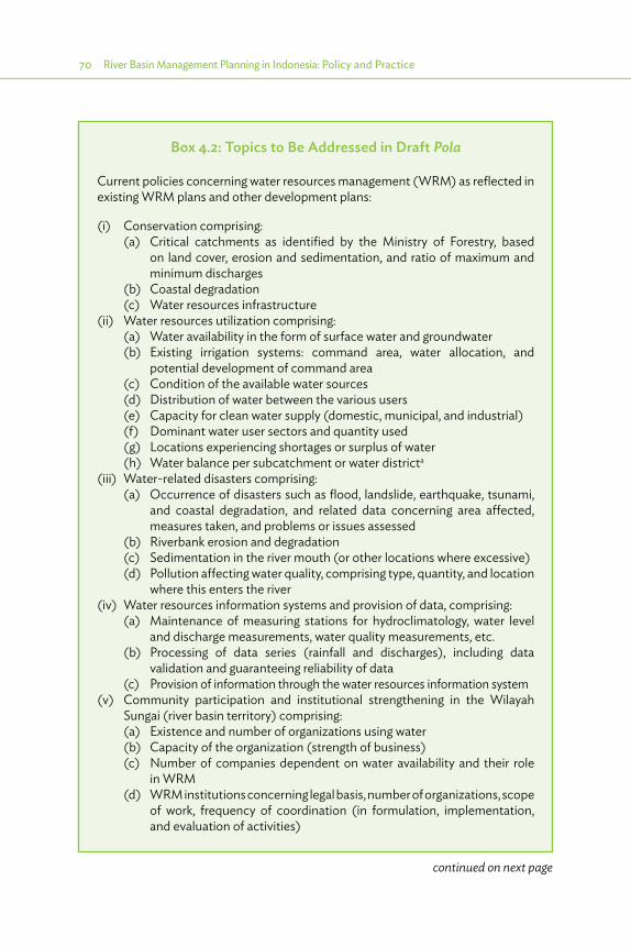
70 River Basin Management Planning in Indonesia: Policy and Practice
Box 4.2: Topics to Be Addressed in Draft Pola
Current policies concerning water resources management (WRM) as reflected in existing WRM plans and other development plans:
(i) Conservation comprising:(a) Critical catchments as identified by the Ministry of Forestry, based
on land cover, erosion and sedimentation, and ratio of maximum and minimum discharges
(b) Coastal degradation(c) Water resources infrastructure
(ii) Water resources utilization comprising:(a) Water availability in the form of surface water and groundwater(b) Existing irrigation systems: command area, water allocation, and
potential development of command area(c) Condition of the available water sources(d) Distribution of water between the various users(e) Capacity for clean water supply (domestic, municipal, and industrial)(f) Dominant water user sectors and quantity used(g) Locations experiencing shortages or surplus of water(h) Water balance per subcatchment or water districta
(iii) Water-related disasters comprising:(a) Occurrence of disasters such as flood, landslide, earthquake, tsunami,
and coastal degradation, and related data concerning area affected, measures taken, and problems or issues assessed
(b) Riverbank erosion and degradation(c) Sedimentation in the river mouth (or other locations where excessive)(d) Pollution affecting water quality, comprising type, quantity, and location
where this enters the river(iv) Water resources information systems and provision of data, comprising:
(a) Maintenance of measuring stations for hydroclimatology, water level and discharge measurements, water quality measurements, etc.
(b) Processing of data series (rainfall and discharges), including data validation and guaranteeing reliability of data
(c) Provision of information through the water resources information system(v) Community participation and institutional strengthening in the Wilayah
Sungai (river basin territory) comprising:(a) Existence and number of organizations using water(b) Capacity of the organization (strength of business)(c) Number of companies dependent on water availability and their role
in WRM(d) WRM institutions concerning legal basis, number of organizations, scope
of work, frequency of coordination (in formulation, implementation, and evaluation of activities)
continued on next page

Basin Planning Required in Indonesia 71
(vi) Potential developments related to WRM comprising:(a) Transport over water(b) Developments in the agriculture, industry, tourism, estate and fisheries
sectors, including business development(vii) Aspirations of the stakeholders related to WRM
a “Water district” is a term used in the simulation models based on River Basin Simulation and concerns an area defined by nodes in the water resources model (such as confluence of river, reservoir, or the main offtake).
Source: Author’s assessment based on PerMen (Ministerial Regulation) PU 22/2009.
Box 4.2 continued
The aim of Step 1.5 Public consultation meeting I (PKM 1) is to assess the aspirations of the stakeholders. During PKM 1, the document prepared under Step 1.4 is presented to all interested stakeholders, both government and nongovernment. To achieve a consensus on the information, the participants are invited to give their inputs as comments, corrections, or additions. KepMen PU 22/2009 suggests participants in the PKM as indicated in Table 4.1.
Table 4.1: Suggested Participants for Public Consultation Meeting (from PerMen PU 22/2009)
No. Institutions
12345–14
15–24
25–31
Directorate General for Water Resources at Ministry of Public WorksWater CouncilB(B)WS or BWS (if existing in this Wilayah Sungai [river basin territory])BPDAS (Center for Catchment Conservation of Ministry of Forestry)Provincial organizations concerning planning (BAPPEDA), environment (BPLHD), public works, water resources (and Balai PSDA), forestry (BPDAS), agriculture, horticulture, communication and traffic, and mining (groundwater)District organizations concerning the same subjectsOther WRM organizations (if existing)UniversitiesOrganization of water using communitiesOrganization of water using businessesNongovernment organizationsTraditional community organizationsOther organizations related to WRM at the provincial or district level
WRM = water resources management.
Source: PerMen (Ministerial Regulation) PU. 2009.
72 River Basin Management Planning in Indonesia: Policy and Practice
The implementation of PKM is usually as follows. Participants are invited through advertisements in the local papers and/or invited based on their known interests. B(B)WS (if WS is under national management), water resources management center at the provincial level (if existing and WS is under provincial management), or service for water resources (at the provincial or district level) organizes the Public Consultation Meeting. Government institutions invited are usually the local planning boards (BAPPEDA), water resources agencies (PU/SDA), agriculture agencies, district- and provincial-level environmental management boards, as well as the relevant Balai Pengelolaan DAS from the Ministry of Forestry. Participants from outside government are usually from nongovernment organizations active in the area, and most are also members of the water councils. But, anyone who is interested can attend.
During PKM 1, the aspects reported in the document pertaining to the problems and potential solutions, strategic issues, and concept agreement on aspirations and objectives for WRM are discussed. The envisaged result of the PKM 1 is an agreed overview of problems and potential solutions, as well as aspirations and objectives for WRM.
4.2.3. Phase 2: FormulationThe formulation stage starts with Step 2.1 Completion of problem inventory and potential development. This will be based on the results of the preparation, especially the document prepared under Step 1.4, and will include a compilation of the aspirations of the various stakeholders and all the objectives for WRM. This step aims to provide a complete overview of WRM aspects in the WS, and to enable formulation of scenarios and strategies for WRM in the following steps.
The next step considers the future development through Step 2.2 Formulation of scenarios for future development in the basin. PerMen 22/2009 indicates that the scenarios should comprise formulation of assumptions for envisaged development of the economy,25 climate change, or political change.26 Usually there are 3–5 scenarios combining the assumptions for the different aspects. The activity also includes assessment of the impacts of these assumptions on conservation, utilization, disasters, information systems, and community participation, as well as current policies. In Section 5.6, the methodology for the development of scenarios and assessment of impacts is discussed further.
25 Which is usually closely related to population growth.26 Interpreted as governance with business as usual, or more proactive governance, with significant
impact on law enforcement concerning spatial planning and conservation of catchments or water quality.

Basin Planning Required in Indonesia 73
A major step comprises Step 2.3 Analysis of basic considerations for WRM. The analysis should comprehensively deal with all the aspects mentioned as pillars of Water Law 7/2004, including the current policies concerning WRM and spatial planning. The guidelines highlight the following aspects as shown in Table 4.2. In Sections 5.2 and 5.4, available methodologies and tools are presented for a rational application in this step.
Table 4.2: Overview of Aspects to Be Analyzed
Data Analysis Result1 Conservation1.1 Spatial plan and land-
use dataTopographical data andDigital Elevation Model (DEM)Maps of catchment and WSMaps of administrative areas
Thematic maps analysis of catchments and WS through geographic information system (GIS)
Maps with boundaries of catchments in relation to boundaries of Wilayah Sungai (WS) and administrative areas (province and district)
1.2 Reports and maps Badan Pengelolaan Daerah Aliran SungaiRainfallSpatial plan and land-use dataTopographical data and DEMMaps (Step 1.1)
Analysis of land cover per catchment through GIS
Land cover, in terms of percentage of area covered, at present and in the next 5, 10, and 20 years
1.3 Rainfall, erosion, and sedimentLand-use mapSoil map, DEM
Analysis of potential erosion using universal soil loss equation
Estimated erosion and sedimentation, at present and in the next 5, 10, and 20 years
1.4 RainfallDischarges (average, max./min.)Soil samples and maps (Step 1.2)
Analysis of sediment (method Imhoff) and Qmax./min.
Estimated sedimentation and Qmax./min. at present and in the next 5, 10, and 20 years
1.5 Current water resources management (WRM) infrastructure
Analysis of current WRM conservation
Estimated performance of conservation assets at present and in the next 5, 10, and 20 years
continued on next page
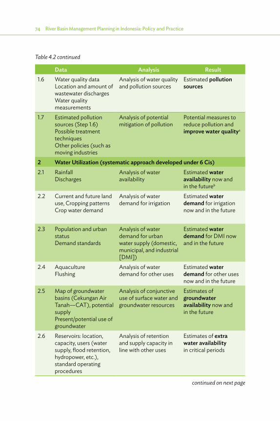
74 River Basin Management Planning in Indonesia: Policy and Practice
Data Analysis Result1.6 Water quality data
Location and amount of wastewater dischargesWater quality measurements
Analysis of water quality and pollution sources
Estimated pollution sources
1.7 Estimated pollution sources (Step 1.6)Possible treatment techniquesOther policies (such as moving industries
Analysis of potential mitigation of pollution
Potential measures to reduce pollution and improve water qualitya
2 Water Utilization (systematic approach developed under 6 Cis)2.1 Rainfall
DischargesAnalysis of water availability
Estimated water availability now and in the futureb
2.2 Current and future land use, Cropping patternsCrop water demand
Analysis of water demand for irrigation
Estimated water demand for irrigation now and in the future
2.3 Population and urban statusDemand standards
Analysis of water demand for urban water supply (domestic, municipal, and industrial [DMI])
Estimated water demand for DMI now and in the future
2.4 AquacultureFlushing
Analysis of water demand for other uses
Estimated water demand for other uses now and in the future
2.5 Map of groundwater basins (Cekungan Air Tanah—CAT), potential supplyPresent/potential use of groundwater
Analysis of conjunctive use of surface water and groundwater resources
Estimates of groundwater availability now and in the future
2.6 Reservoirs: location, capacity, users (water supply, flood retention, hydropower, etc.), standard operating procedures
Analysis of retention and supply capacity in line with other uses
Estimates of extra water availability in critical periods
Table 4.2 continued
continued on next page

Basin Planning Required in Indonesia 75
Data Analysis Result2.7 Water availability
(result Step 2.1)Present and future water demand (Steps 2.2–2.4)Groundwater availability (Step 2.5)Reservoir capacity (result Step 2.6)
Analysis of water balance per water district
Estimated chance of failure in meeting required water demand, Identification of shortages and surplus
2.8 Current infrastructure and WRM assets
Analysis of current water supply
Estimated performance of WRM assets now and in the future
2.9 Shortages and surpluses (result Step 2.7)WRM asset performance (result Step 2.8)DEM
Assessment of potential development of additional WRM assets
Indication of required and potential additional WRM assets
2.10 Land-use data + DEMTidal information, salinity in riverIrrigation assets, present and potential
Assessment of potential tidal irrigation and water supply
Estimated potential for tidal irrigation/water supply
3 Disasters3.1 Flood zones +
frequency of floodsOther disaster areas + frequencyLand-use map + DEMDamage from disastersMeasures to mitigate disaster
Analysis of various types of disasters (location, frequency, damage) and possible mitigation
Overview of disasters, in terms of location, frequencies, and damage (and possible mitigation added under 6 Cis)
3.2 Current infrastructure and WRM assets
Analysis of protection or disaster mitigation
Estimated performance of WRM assets now and in the future
4 Water Resources Information System4.1 Location and condition
of measuring stations (rainfall, water level/discharge, weather, water quality)
Assessment of adequate functioning (reliability and completeness of data) and coverage
Recommendations for improvements in functioning and coverage of measuring stations
continued on next page
Table 4.2 continued
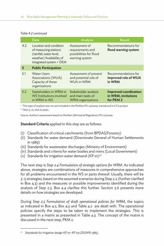
76 River Basin Management Planning in Indonesia: Policy and Practice
Data Analysis Result4.2 Location and condition
of measuring stations (rainfall, water level, weather) Availability of integrated system + DEM
Assessment of requirements and possibilities for flood warning system
Recommendations for flood warning system
5 Public Participation5.1 Water Users
Associations (WUA)Capacity of these organizations
Assessment of present and potential role of WUA in WRM
Recommendations for improved role of WUA in WRM
5.2 Stakeholders in WRM in WS Institutions involved in WRM in WS
Stakeholder analysis and main tasks of WRM organizations
Improved coordination in WRM, invitations for PKM 2
a This type of analysis was not yet included in the PerMen PU 22/2009, introduced in 6 Cis project b Next 5, 10, and 20 years.
Source: Author’s assessment based on PerMen (Ministerial Regulation) PU 22/2009.
Standard Criteria applied in this step are as follows:
(i) Classification of critical catchments (from BPDAS/Forestry)(ii) Standards for water demand (Directorate General of Human Settlements
in 1989)(iii) Standards for wastewater discharges (Ministry of Environment)(iv) Standards and criteria for water bodies and rivers (Local Government)(v) Standards for irrigation water demand (KP 01)27
The next step is Step 2.4 Formulation of strategic options for WRM. As indicated above, strategies are combinations of measures in comprehensive approaches for all problems encountered in the WS or parts thereof. Usually, there will be 3–5 strategies, based on the assumed scenarios during Step 2.2 (further clarified in Box 4.3) and the measures or possible improvements identified during the analysis of Step 2.3. Box 4.4 clarifies this further. Section 5.6 presents more details on how strategies are developed.
During Step 2.5 Formulation of draft operational policies for WRM, the topics as indicated in Box 4.2, Box 4.5 and Table 4.2 are dealt with. The operational policies specify the steps to be taken to implement the strategies. This is presented in a matrix as presented in Table 4.3. The concept of the matrix is discussed in the next step, PKM 2.
27 Standards for irrigation design KP 01–KP 09 (DGWR 1985).
Table 4.2 continued
Basin Planning Required in Indonesia 77
Box 4.4: Main Strategies and Specific Strategies
The Pola (strategic framework plan) formulates two types of strategies:
(i) Specific strategies related to specific problems. These specific strategies mostly comprise a list of specific measures to solve the specified problems.
(ii) Overall main strategies comprising a combination of specific strategies for specific problems and related to assumed scenarios for future development.
Box 4.3: Scenarios
Scenarios are projections for various alternative future developments. PerMen 22/2009 requires scenarios for
(i) political development, (ii) economic development, and (iii) climate change.
Political development can be stable or unstable; a stable government can ensure high economic growth, which may not be the case otherwise. In 6 Cis, the alternative political developments were “following the current trend” or alternatively were “proactive”; in the first case, awareness and law enforcement will be present, while a proactive government will be more active in raising awareness and law enforcement.
Economic development usually has two optional scenarios: high or low.
In 6 Cis, there are three options: low (to be prepared for the worst), most likely (current trend), and high (beyond current trend, to be prepared for high requirements, but also offering higher budgets). It is assumed that the government cannot afford to be not proactive in the case of high economic growth.
Climate change is normally taken as a given fact, and does not lead to different scenarios.
More about strategies and scenarios is indicated in Section 5.4. Tools.
Note: 6 Cis refers to the six rivers project (TA 7189) (2009-2013).
Source: Author.
continued on next page

78 River Basin Management Planning in Indonesia: Policy and Practice
Step 2.6 Implementation of Public Consultation Meeting II (PKM 2) is implemented with the same persons and institutions as mentioned in Step 1.5. During this step, the concept matrix for operational policies (as shown for the Citarum WS as an example in Table 4.3) is presented to the stakeholders for their comments, adjustments, additions, and corrections. The product of PKM 2 is agreement on the final matrix for operational policies, and therefore an agreement on the steps to be taken to implement the strategies. Final selection of the preferred strategy is done in the early stages of the Rencana process.
In the matrix for operational policies (kebijakaan operasional, see next Step 2.5), there is for each identified problem at least one specific strategy to achieve the target in the short, medium, and long term. As such, there can be a large number of specific strategies, each related to one identified problem, up to 100 or more. However, there are only a limited number of overall main strategies with a combination of specific strategies for specific problems and related to assumed scenarios. Usually, there are 3–5 main strategies related at least to low, medium, and high economic growth scenarios, and some specific other scenarios for that Wilayah Sungai (river basin territory). The Pola for 6 Cis identifies four scenarios and four main strategies for low, medium and high economic growth, each with a proactive government, and one more strategy for low economic growth, one with a current trend following government.
Selection of strategies, as mentioned in PerMen 22/2009, relates to the overall main strategies. The PerMen states that the scenarios should be related to political development, economic development, and climate change. Most overall main strategies are based on the assumed economic development, with a high, medium, or low economic scenario, and possibly on some other assumptions as well (such as current trend following or proactive governance), but climate change is normally taken as a given fact and does not lead to different scenarios and main strategies. More about strategies and scenarios is described in Section 5.4. Tools.
Each specific strategy related to a certain problem is related to one of the overall main strategies. Hence, the selection of overall main strategies also determines the problem-related strategies. In the formulation of Rencana (master plan), the strategies (type 1, related to problems) become the first identifier, but the problems are not mentioned anymore in the matrix of the program and activities prepared in the next steps.
Note: 6 Cis refers to the six rivers project (TA 7189) (2009–2013).
Source: Author’s assessment based on many Polas and Rencanas as prepared for the Directorate General for Water Resources at Ministry of Public Works, and international experience.
Box 4.4 continued

Basin Planning Required in Indonesia 79
Box 4.5: Topics for Discussion in Step 2.5
This will address the five pillars of Law 7/2004 as indicated in Section 4.1 as well as address ongoing policies on water resources and spatial planning, as follows:
(i) Conservation(ii) Utilization(iii) Damage control(iv) Information system(v) Public participation(vi) Current water resources and spatial
planning
The various main topics are subdivided into subtopics, as follows:
(i) Conservationa. Erosionb. Watershed degradationc. Protected areasd. Water quality managemente. Land use in watersheds (effects on flood flows and dry season flows)f. Land subsidenceg. Climate change effects on water resources management
(ii) Utilizationa. Water allocation
1. Water availability and water use for various functions: shortages and surpluses
2. Priorities in water allocationb. Water resources development
1. Need for interbasin surface water transfer (such as to guarantee water supply to Jakarta)
2. Need for upgrading irrigation system to increase efficiency and reduce demands
3. Need for water quality management, especially to meet demand for domestic, municipal, and industrial water supply
c. Social and ecological function of water
Conservation
Utilization Disaster
Spatialplanning
Institutional
Dataand
information Participatory
continued on next page
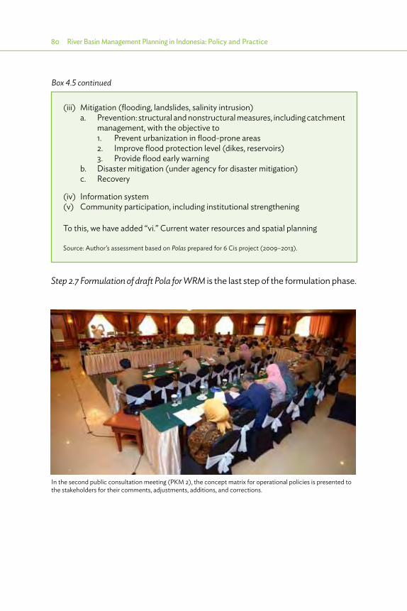
80 River Basin Management Planning in Indonesia: Policy and Practice
Step 2.7 Formulation of draft Pola for WRM is the last step of the formulation phase.
(iii) Mitigation (flooding, landslides, salinity intrusion)a. Prevention: structural and nonstructural measures, including catchment
management, with the objective to1. Prevent urbanization in flood-prone areas2. Improve flood protection level (dikes, reservoirs)3. Provide flood early warning
b. Disaster mitigation (under agency for disaster mitigation)c. Recovery
(iv) Information system(v) Community participation, including institutional strengthening
To this, we have added “vi.” Current water resources and spatial planning
Source: Author’s assessment based on Polas prepared for 6 Cis project (2009–2013).
Box 4.5 continued
In the second public consultation meeting (PKM 2), the concept matrix for operational policies is presented to the stakeholders for their comments, adjustments, additions, and corrections.

Basin Planning Required in Indonesia 81
Tabl
e 4.
3 : M
atrix
of O
pera
tiona
l Pol
icie
s
No.
Asp
ect/
Suba
spec
t1 A
2 B3 C
4 DPr
oble
ms B
ased
on
Ana
lysis
Des
ired
Targ
et/
Obj
ectiv
e
STRA
TEG
Y
Ope
ratio
nal
Polic
ies
Inst
itutio
n/A
genc
y Re
late
d
iSh
ort T
erm
(2
011-
2015
)
ii +
iM
ediu
m T
erm
(2
011-
2020
)
iii +
ii +
iLo
ng T
erm
(2
011-
2030
)
1CO
NSE
RVAT
ION
1.1W
ATER
RE
SOU
RCES
PR
OTE
CTIO
N A
ND
SU
STA
ININ
G
1) T
abel
4.3
. Ke
bija
kan
Ope
rasio
nal
Peng
elol
aan
Peng
elol
aan
Sum
ber D
aya
Air
di W
S 6
Ci (B
BWS
1 Ci)
pada
Ske
nario
1,
2, 3
dan
4
• �Im
plem
entatio
n �of
land
co
nser
vatio
n is
very
crit
ical
and
cr
itica
l wat
ersh
ed
area
s in
the
Cita
rum
• �Dissem
inate �to�
the
publ
ic o
n Te
chni
cal P
lan
for
Fore
st a
nd L
and
Reha
bilit
atio
n (R
TkRH
L) =
20
11 to
201
3,
carry
ing o
ut
activ
ities
on
very
cr
itica
l RTk
RHL
40%
and
15%
of
criti
cal la
nd a
rea
(201
4-20
15)
• �Perfo
rm�activities�
on la
nd ve
ry
criti
cal R
TkRH
L 60
% a
rea,
cu
mul
ativ
e to
10
0%, a
nd 3
5%
of c
ritic
al la
nd
area
, cum
ulat
ive
to 5
0%.
• �Co
nductin
g �RT
kRH
L on
de
grad
ed la
nd
area
of 5
0%,
cum
ulat
ive
to
100%
, as w
ell
as m
onito
r and
m
aint
ain
the
reha
bilit
ated
fo
rest
con
ditio
ns.
• �Im
plem
ent �
RTkR
HL
in
prio
rity a
reas
in
the
upst
r eam
w
ater
shed
an
d up
stre
am
rese
rvoi
rs/d
ams
plan
.
Dep
artm
ent
of A
gric
ultu
re
Fore
stry
and
Pl
anta
tion
outs
ide
the
Fore
st, M
PU,
rela
ted
Rege
nt,
BPD
AS,
BBW
S,
Com
mun
ity
grou
ps, t
he
Prov
inci
al F
ores
try
Age
ncy,
Nat
ural
Re
sour
ces
Cons
erva
tion
Coun
cil, P
erum
Pe
rhut
ani, P
T.
Bakt
i Usa
ha
Men
anam
N
usan
tara
Hija
u Le
st
2)
and
so fo
rth….
1.2W
ATER
RE
SOU
RCES
PR
ESER
VED
1) N
ot o
ptim
al
cons
truct
ion
of
wat
er re
serv
oir
(stil
l a lo
t of w
ater
is
was
ted
durin
g th
e ra
iny s
easo
n)
• �Increased�
rese
rvoi
r, Si
tu a
nd
rete
ntio
n po
nds
• �Bu
ild�a�dam
,�lake�
and
rete
ntio
n po
nds a
s nee
ded
• �Bu
ild�a�dam
,�lake�
and
rete
ntio
n po
nds a
s nee
ded
• �Bu
ild�a�dam
,�lake�
and
rete
ntio
n po
nds a
s nee
ded
• �Bu
ild�a�dam
,�lake�
and
rete
ntio
n po
nds a
s lon
g-te
rm n
eede
d
BBW
S, M
PU
Age
ncy/
Prov
inci
al
WRM
Age
ncy,
WRM
Cou
ncil
2)
and
so fo
rth….
cont
inue
d on
nex
t pag
e
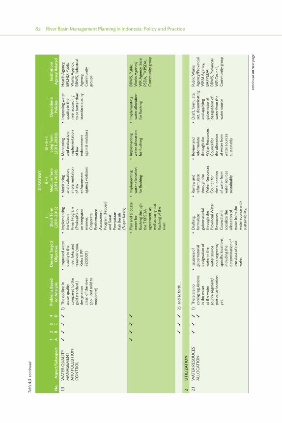
82 River Basin Management Planning in Indonesia: Policy and Practice
No.
Asp
ect/
Suba
spec
t1 A
2 B3 C
4 DPr
oble
ms B
ased
on
Ana
lysis
Des
ired
Targ
et/
Obj
ectiv
e
STRA
TEG
Y
Ope
ratio
nal
Polic
ies
Inst
itutio
n/A
genc
y Re
late
d
iSh
ort T
erm
(2
011-
2015
)
ii +
iM
ediu
m T
erm
(2
011-
2020
)
iii +
ii +
iLo
ng T
erm
(2
011-
2030
)
1.3W
ATER
QU
ALI
TY
MA
NAG
EMEN
T A
ND
PO
LLU
TIO
N
CON
TRO
L
1) T
he d
eclin
e in
w
ater
qua
lity
com
pare
d to
the
gold
stan
dard
/
desig
natio
n cl
ass
of th
e riv
er
(pol
lute
d m
ild to
m
oder
ate)
• �Im
proved�water�
qual
ity in
the
river
, lake
, and
re
serv
oir (
min
. Ke
las I
I PP
82/2
001)
• �Im
plem
entin
g�th
e Cl
ean
Rive
r Pro
gram
(P
roka
sih) i
n an
inte
grat
ed
man
ner,
Corp
orat
e Pe
rform
ance
A
sses
smen
t Pr
ogra
m (P
rope
r)
and
Sura
t Pe
rnya
taan
Ka
li Ber
sih
(Sup
er K
asih
)
• �Monito
ring �
and
eval
uatio
n,
impl
emen
tatio
n of
law
en
forc
emen
t ag
ains
t vio
lato
rs
• �Monito
ring�
and
eval
uatio
n,
impl
emen
tatio
n of
law
en
forc
emen
t ag
ains
t vio
lato
rs
• �Im
proving�w
ater�
qual
ity in
the
river
acc
ordi
ng
to o
r bet
ter t
han
stan
dard
qua
lity
Hea
tlh A
genc
y, BP
LHD
, Pub
lic
Wor
ks A
genc
y, BB
WS,
Indu
stria
l A
genc
y, Co
mm
unity
gr
oups
• �Plan�and�allocate�
wat
er fo
r flu
shin
g thr
ough
th
e TK
PSD
A
agre
emen
t, as
w
ell a
s car
ry o
ut
flush
ing o
f the
riv
er.
• �Im
plem
entin
g�w
ater
allo
catio
n fo
r flus
hing
• �Im
plem
entin
g�w
ater
allo
catio
n fo
r flus
hing
• �Im
plem
entin
g�w
ater
allo
catio
n fo
r flus
hing
BBW
S, P
ublic
W
orks
Age
ncy/
WR
Age
ncy,
Bala
i PS
DA
, TKP
SDA
, Co
mm
unity
grou
p
2)
and
so fo
rth….
2U
TILI
ZATI
ON
2.1
WAT
ER R
ESO
UCE
S A
LLO
CATI
ON
1)
The
re a
re n
o zo
ning
regu
latio
ns
in th
e w
ater
at
the
wat
er
sour
ce se
gmen
t/ pa
rticu
lar l
ocat
ion
yet.
• �Issuance�of�
gube
rnat
oria
l de
signa
tion
of
wat
er in
the
wat
er so
urce
on
a se
gmen
t/sp
ecifi
c lo
catio
ns,
incl
udin
g the
de
term
inat
ion
of
the
clas
s of r
iver
w
ater
.
• �Drafting,�
form
ulat
e gu
bern
ator
ial
thro
ugh
the
Prov
inci
al W
ater
Re
sour
ces
Coun
cil a
nd
soci
alize
the
allo
catio
n of
w
ater
from
the
wat
er so
urce
with
su
stai
nabi
lity.
• �Re
view
�and�
refo
rmul
ate
thro
ugh
the
Wat
er R
esou
rces
Co
unci
l for
th
e al
loca
tion
of w
ater
from
w
ater
sour
ces
sust
aina
bly
• �Re
view
�and�
refo
rmul
ate
thro
ugh
the
Wat
er R
esou
rces
Co
unci
l for
th
e al
loca
tion
of w
ater
from
w
ater
sour
ces
sust
aina
bly
• �Draft,�form
ulate,�
set,
diss
emin
atin
g an
d ap
plyi
ng
gube
rnat
oria
l de
signa
tion
of
wat
er fr
om th
e w
ater
sour
ce
Publ
ic W
orks
A
genc
y/Pr
ovin
cial
W
RM A
genc
y, BA
PPED
A,
BBW
S, P
rovi
ncia
l W
R Co
unci
l, Co
mm
unity
grou
p
cont
inue
d on
nex
t pag
e
Tabl
e 4.3
con
tinue
d

Basin Planning Required in Indonesia 83
No.
Asp
ect/
Suba
spec
t1 A
2 B3 C
4 DPr
oble
ms B
ased
on
Ana
lysis
Des
ired
Targ
et/
Obj
ectiv
e
STRA
TEG
Y
Ope
ratio
nal
Polic
ies
Inst
itutio
n/A
genc
y Re
late
d
iSh
ort T
erm
(2
011-
2015
)
ii +
iM
ediu
m T
erm
(2
011-
2020
)
iii +
ii +
iLo
ng T
erm
(2
011-
2030
)
2) T
here
is n
o zo
ning
us
e of
wat
er re
sour
ce
that
take
s int
o ac
coun
t a w
ide
rang
e of
util
izatio
n ye
t.
• �Issuance �of�
zoni
ng a
nd
harm
onize
the
utiliz
a tio
n of
w
ater
reso
urce
s in
Spa
tial m
aps
of W
est J
ava
Prov
ince
• �Zo
ning�
utiliz
atio
n of
w
ater
reso
urce
s an
d ha
rmon
ize
the
spat
ial
plan
ning
map
s of
pro
vinc
ial a
nd
dist
rict/c
ity.
• �Re
view
ing�a
nd�
rees
tabl
ishm
ent
of th
e w
ater
zo
ning
util
izatio
n an
d ha
rmon
ize
the
Spat
ial m
aps
of p
rovi
ncia
l, di
stric
t/city
.
• �Monito
r�the�
impl
emen
tatio
n of
wat
er zo
ning
ut
ilizat
ion
and
mak
e ne
cess
ary
revi
sions
.
• �Re
view
ing�a
nd�
rees
tabl
ishm
ent
of w
ater
zoni
ng
utiliz
atio
n an
d ha
rmon
ize in
to
the
spat
ial m
aps
of p
rovi
ncia
l, di
stric
t/city
.
BAPP
EDA
, H
ousin
g &
Settl
emen
t A
genc
y, Pu
blic
W
orks
Age
ncy/
Prov
inci
al W
RM
Age
ncy,
BBW
S,
Com
mun
ity gr
oup
3)
and
so fo
rth….
2.2
WAT
ER
RESO
URC
ES
PRO
VISI
ON
1) W
ater
shor
tage
su
pply
for i
rriga
tion
and
DM
I.
* In
crea
sed
wat
er
use
effici
ency
• �Practice�
cam
paig
n an
d ed
ucat
ion
of D
MI
wat
er-s
avin
g and
irr
igat
ion
wat
er
effici
ency
(3R)
• �Practice �c
ampaign�
and
educ
atio
n of
D
MI w
ater
-sav
ing
and
irrig
atio
n w
ater
effi
cien
cy
(3R)
• �Practice �
cam
paig
n an
d ed
ucat
ion
of D
MI
wat
er-s
avin
g and
irr
igat
ion
wat
er
effici
ency
(3R)
• �Re
duce�wa ter�
dem
and
thro
ugh
DM
I w
a ter
-sav
ing a
nd
irrig
atio
n w
ater
effi
cien
cy
Publ
ic W
orks
A
genc
y/Pr
ovin
cial
W
RM A
genc
y, H
ousin
g &
Settl
emen
t A
genc
y, W
ater
U
ser i
n W
est
Java
and
Ja
karta
, BBW
S,
Com
mun
ity gr
oup
* Re
duce
the
pilfe
rage
and
w
asta
ge o
f wat
er
in D
MI a
nd
irrig
atio
n
• �Practice�
cam
paig
n an
d W
ater
Usa
ge
Righ
t edu
catio
n.
Mon
itorin
g th
e bu
lk w
ater
al
loca
tion
for D
MI a
nd
irrig
atio
n
• �Practice�c
ampaign�
and
Wat
er U
sage
Ri
ght e
duca
tion.
M
onito
ring a
nd
impl
emen
ting l
aw
enfo
rcem
ent o
n th
e bu
lk w
ater
al
loca
tion
for D
MI
and
irrig
atio
n
• �Practice�
cam
paig
n an
d W
ater
Usa
ge
Righ
t edu
catio
n.
Mon
itorin
g and
im
plem
entin
g la
w e
nfor
cem
ent
on th
e bu
lk
wat
er a
lloca
tion
for D
MI a
nd
irrig
atio
n
• �Govern�the�
surfa
ce w
ater
al
loca
tion
for
DM
I acc
ordi
ng
to S
IPA
, and
fo
r irri
gatio
n as
ne
eded
, with
law
en
forc
emen
t for
vi
olat
ors.
BBW
S, In
dust
rial
Age
ncy,
Publ
ic
Wor
ks A
genc
y/Pr
ovin
cial
W
RM A
genc
y, Po
lice,
WU
A,
Com
mun
ity gr
oup
2)
and
so fo
rth….
2.3
WAT
ER
RESO
URC
ES
UTI
LIZA
TIO
N
1) W
ater
use
r co
nflic
ts o
n irr
igat
ion
and
raw
wat
er
utiliz
atio
n in
the
Cita
rum
are
a
* H
arm
oniza
tion
of
the
wat
er u
ser o
n irr
igat
ion
and
raw
w
ater
util
izatio
n in
the
Cita
rum
ar
ea
• �Re
view
ing�a
nd�
impl
emen
ting
appr
opria
te
wat
er a
lloca
tion
agre
emen
t
• �Im
plem
entin
g�ap
prop
riat e
wat
er
allo
catio
n on
an
ongo
ing b
asis
• �Im
plem
entin
g�ap
prop
riat e
wat
er
allo
catio
n on
an
ongo
ing b
asis
• �Im
plem
entin
g�w
ater
allo
catio
n as
app
ropr
iate
ac
cord
ing t
o w
ater
reso
urce
ut
ilizat
ion
prin
cipl
es.
TKPS
DA
, BBW
S,
Prov
inci
al/R
egen
t W
RM A
genc
y, BP
SDA
, PJT
-II,
Com
mun
ity gr
oup
Tabl
e 4.3
con
tinue
d
cont
inue
d on
nex
t pag
e
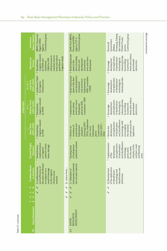
84 River Basin Management Planning in Indonesia: Policy and Practice
No.
Asp
ect/
Suba
spec
t1 A
2 B3 C
4 DPr
oble
ms B
ased
on
Ana
lysis
Des
ired
Targ
et/
Obj
ectiv
e
STRA
TEG
Y
Ope
ratio
nal
Polic
ies
Inst
itutio
n/A
genc
y Re
late
d
iSh
ort T
erm
(2
011-
2015
)
ii +
iM
ediu
m T
erm
(2
011-
2020
)
iii +
ii +
iLo
ng T
erm
(2
011-
2030
)
2)
Ineff
ectiv
enes
s an
d in
effici
ency
of
the
wat
er d
istrib
utio
n on
irrig
atio
n as
a
resu
lt of
dam
age
to th
e irr
igat
ion
infra
stru
ctur
e ne
twor
k
* Re
habi
litat
ion
impl
emen
tatio
n on
irrig
atio
n ne
twor
k mai
nly
heav
y dam
age
• �Re
habilitate �
irrig
atio
n ne
twor
k by
50%
* Re
habi
litat
e irr
igat
ion
netw
ork
by 10
0%
• �Im
plem
ent �O
&M�
for i
rriga
tion
infra
stru
ctur
e
• �Re
habilitate�
irrig
atio
n ne
twor
k by
100%
and
im
plem
ent
O&
M fo
r WR
infra
stru
ctur
e to
m
aint
ain
serv
ice
leve
l and
redu
ce
peak
flow
of
irrig
atio
n ne
eds
BBW
S, P
rovi
ncia
l/Re
gent
WRM
A
genc
y, Co
mm
unity
grou
p
3)
and
so fo
rth….
2.4
WAT
ER
RESO
URC
ES
DEV
ELO
PMEN
T
1)
Util
izatio
n of
hy
drop
ower
pot
entia
l ha
s not
bee
n op
timal
.
* D
evel
opm
ent
of h
ydro
pow
er
pote
ntia
l rea
lized
.
• �Perfo
rm�an�
inve
ntor
y of
pote
ntia
l and
hy
drop
ower
ut
ilizat
ion
plan
ning
(201
1–20
13),
impl
emen
t m
ini-m
icro
hy
drop
ower
pl
ants
co
nstru
ctio
n (2
014–
2015
=
20%
)
• �Im
plem
ent�the�
pow
er p
lant
s an
d m
ini-m
icro
hy
drop
ower
pl
ants
by 3
0%,
cum
ulat
ive
= 60
%
• �Bu
ild�hydropower�
plan
t in
the
dam
an
d de
velo
pmen
t of
pot
entia
l m
ini a
nd m
icro
hy
drop
ower
by
40%
, cum
ulat
ive
= 10
0%
• �Bu
ild�hydropower�
plan
t in
the
dam
(inc
ludi
ng
Karia
n) a
nd
deve
lopm
ent
of p
oten
tial
min
i and
mic
ro
hydr
opow
er
EMR,
PLN
, BBW
S,
Prov
inci
al W
RM
Age
ncy,
PJT-
II,
Com
mun
ity gr
oup
2) D
evel
opm
ent
of th
e ap
plic
atio
n of
des
alin
atio
n te
chno
logy
and
ul
trafil
tratio
n ar
e
still
limite
d.
* Im
plem
enta
tion
of th
e de
velo
pmen
t an
d ap
plic
atio
n of
des
alin
atio
n an
d ul
trafil
tratio
n te
chno
logy
, pa
rticu
larly
fo
r the
wat
er
indu
stry
in th
e no
rther
n co
ast
and
Band
ung
area
s.
• �Re
view
�the�
deve
lopm
ent
and
appl
icat
ion
of d
esal
inat
ion
and
ultra
filtra
tion
tech
nolo
gy, w
ith
enco
urag
ing
the
indu
stry
/pr
ivat
e se
ctor
for
appl
icat
ion.
• �Encourage�
deve
lopm
ent
and
appl
icat
ion
of d
esal
inat
ion
tech
nolo
gy b
y in
dust
ry/p
rivat
e by
pro
vidi
ng
ince
ntiv
e fo
r th
ose
who
redu
ce
grou
ndw
ater
ab
stra
ctio
n.
• �Encourage�
deve
lopm
ent
and
appl
icat
ion
of d
esal
inat
ion
tech
nolo
gy b
y in
dust
ry/p
rivat
e.
• �Encourage�
deve
lopm
ent
and
appl
icat
ion
of d
esal
inat
ion
tech
nolo
gy b
y in
dust
ry/p
rivat
e by
pro
vidi
ng
ince
ntiv
e fo
r th
ose
who
redu
ce
grou
ndw
ater
ab
stra
ctio
n.
Prov
inci
al
Gov
ernm
ent
(Bek
asi,
Kara
wan
g, Su
bang
da
n In
dram
ayu)
, PD
AM
, Priv
ate
sect
ors,
Com
mun
ity gr
oup
cont
inue
d on
nex
t pag
e
Tabl
e 4.3
con
tinue
d

Basin Planning Required in Indonesia 85
No.
Asp
ect/
Suba
spec
t1 A
2 B3 C
4 DPr
oble
ms B
ased
on
Ana
lysis
Des
ired
Targ
et/
Obj
ectiv
e
STRA
TEG
Y
Ope
ratio
nal
Polic
ies
Inst
itutio
n/A
genc
y Re
late
d
iSh
ort T
erm
(2
011-
2015
)
ii +
iM
ediu
m T
erm
(2
011-
2020
)
iii +
ii +
iLo
ng T
erm
(2
011-
2030
)
3M
ITIG
ATIO
N (F
lood
ing,
Lan
dslid
es, S
alin
ity In
trus
ion)
3.1
PREV
ENTI
ON
1) N
o av
aila
ible
M
aste
r Pla
n fo
r Fl
ood
Cont
rol
Syst
em a
s a w
hole
in
the
Cita
rum
riv
er.
• �Th
e �completion�
of M
aste
r Pl
an fo
r floo
d m
anag
emen
t sy
stem
as a
who
le
in th
e Ci
taru
m
river
• �Set �u
p�the�Master�
Plan
for fl
ood
man
agem
ent
s yst
em a
s a w
hole
in
the
Cita
rum
riv
er.
• �Programs�
impl
emen
tatio
n on
the
mas
ter
plan
as a
who
le in
th
e Ci
taru
m ri
ver.
• �Program�
impl
emen
tatio
n an
d O
&M
on
the
flood
m
anag
emen
t sy
stem
in th
e Ci
taru
m ri
ver
• �Reduce�victims/
lost
due
to fl
ood
and
redu
ce
frequ
ency
of fl
ood
even
t with
plan
for
agric
ultu
ral a
rea
Q5,
and
urba
n ar
ea Q
25
BBW
S, P
ublic
W
orks
Age
ncy/
Prov
inci
al W
RM
Age
ncy,
BPSD
A,
Com
mun
ity gr
oup
2) D
ecre
asin
g of
flood
con
trol
infra
stru
ctur
e in
th
e Ci
taru
m ri
ver.
• �Achieving�the�
impr
ovem
ent,
reha
bilit
atio
n an
d m
aint
enan
ce
of fl
ood
cont
rol
infra
stru
ctur
e in
th
e Ci
taru
m ri
ver.
• �Plan�and�
impl
emen
t em
erge
ncy
r esp
onse
the
colla
pse
dike
s al
ong 9
65 m
an
d 16
.600
m
criti
cal d
ikes
alon
g Cita
rum
do
wns
tream
, an
d re
habi
litat
e 15
4 km
dike
s al
ong K
ampu
ng
Bojo
ng to
Mua
ra
Gem
bong
, bu
ildin
g new
dike
an
d flo
od c
ontro
l st
ruct
ure
at
Cibe
et ri
ver (
pe
• �Sustainable�
impl
emen
tatio
n an
d m
aint
enan
ce
of fl
ood
cont
rol
infra
stru
ctur
es
• �Sustainable �
impr
ovem
ent
and
reha
bilit
atio
n an
d m
aint
enan
ce
of fl
ood
cont
rol
infra
stru
ctur
es
• �Maintain �
func
tion
of fl
ood
cont
rol s
truct
ure
in su
stai
nabl
e w
ays
BBW
S, P
ublic
W
orks
Age
ncy/
Prov
inci
al W
RM
Age
ncy,
BPSD
A,
Com
mun
ity gr
oup
3) a
nd so
forth
….
3.2
MIT
IGAT
ION
1) E
mer
genc
y re
spon
se d
ue
to fl
oods
• �Minimize
�the�
lo
ss re
sulti
ng
from
floo
d
• �Menyediakan�
baha
n ba
njira
n se
tiap
tahu
n da
n da
na o
pera
siona
l se
cara
be
rkel
anju
tan
• �Menyediakan�
baha
n ba
njira
n se
tiap
tahu
n da
n da
na o
pera
siona
l se
cara
be
rkel
anju
tan
• �Menyediakan�
baha
n ba
njira
n se
tiap
tahu
n da
n da
na o
pera
siona
l se
cara
be
rkel
anju
tan
• �Minimize
�the�loss�
resu
lting
from
flo
od
BPBD
(Reg
iona
l D
isast
er
Miti
gatio
n Bo
ard)
, BN
PB
(Nat
iona
l Disa
ster
M
itiga
tion
Boar
d),
Prov
inci
al W
RM
Age
ncy,
BBW
S,
Indo
nesia
n Re
dCro
ss,
Com
mun
ity gr
oup
cont
inue
d on
nex
t pag
e
Tabl
e 4.3
con
tinue
d
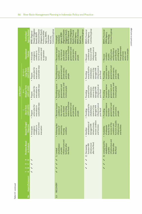
86 River Basin Management Planning in Indonesia: Policy and Practice
No.
Asp
ect/
Suba
spec
t1 A
2 B3 C
4 DPr
oble
ms B
ased
on
Ana
lysis
Des
ired
Targ
et/
Obj
ectiv
e
STRA
TEG
Y
Ope
ratio
nal
Polic
ies
Inst
itutio
n/A
genc
y Re
late
d
iSh
ort T
erm
(2
011-
2015
)
ii +
iM
ediu
m T
erm
(2
011-
2020
)
iii +
ii +
iLo
ng T
erm
(2
011-
2030
)
• �Anticipate �
emer
genc
y co
nditi
on in
t e
rm o
f vic
tims’
evac
uatio
n
• �Prepare�
actio
n pl
an fo
r ev
acua
tion
in
sust
aina
ble
way
s
• �Prepare�
actio
n pl
an fo
r ev
acua
tion
in
sust
aina
ble
way
s
• �Prepare�
actio
n pl
an fo
r ev
acua
tion
in
sust
aina
ble
way
s
• �Anticipate�
emer
genc
y co
nditi
on in
t e
rms o
f vic
tims’
evac
uatio
n an
d its
ope
ratio
n fu
nd
BPBD
(Reg
iona
l D
isast
er M
itiga
tion
Boar
d), B
NPB
(N
atio
nal D
isast
er
Miti
gatio
n Bo
ard)
, Pr
ovin
cial
WRM
A
genc
y, BB
WS,
In
done
sian
RedC
ross
, Co
mm
unity
grou
p
3.3
RECO
VERY
1) L
imite
d re
habi
litat
ion
of p
ublic
in
frast
ruct
ure
and
faci
litie
s afte
r th
e flo
od.
• �Achieving�the�
reco
very
of
com
mun
ity
hous
ing
cond
ition
• �Re
cover �house’s�
cond
ition
of
the
vict
ims a
t po
st d
isast
er
by p
rovi
ding
re
serv
e fu
nd fr
om
gove
rnm
ent a
nd
priv
ate
sect
or,
and
invo
lve
peop
le
• ��Providing �reserve�
fund
from
go
vern
men
t and
pr
ivat
e se
ctor
, and
in
volv
e pe
ople
• �Providing �reserve�
fund
from
go
vern
men
t and
pr
ivat
e se
ctor
, an
d in
volv
e pe
ople
• �Re
cover �house’s�
cond
ition
of
the
vict
ims a
t po
st d
isast
er
by p
rovi
ding
re
serv
e fu
nd fr
om
gove
rnm
ent a
nd
priv
ate
sect
or,
and
invo
lve
peop
le
Hou
sing &
Se
ttlem
ent
Agen
cy, B
PBD
(R
egio
nal D
isast
er
Miti
gatio
n Bo
ard)
, BN
PB (N
atio
nal
Disa
ster
Miti
gatio
n Bo
ard)
, Pro
vincia
l W
RM A
genc
y, BB
WS,
Indo
nesia
n Re
dCro
ss,
Com
mun
ity gr
oup
2)
Dec
reas
ing
func
tion
WR
infra
stru
ctur
e af
ter t
he fl
ood
• �Manifest�
reha
bilit
atio
n of
da
mag
ed W
R in
frast
ruct
ures
, re
cove
r con
ditio
n an
d fu
nctio
n.
• �Providing�
annu
al fu
nd fo
r re
habi
litat
ion
rese
rve
of th
e da
mag
ed W
R in
frast
ruct
ure
at
post
floo
d
• �Providing�
annu
al fu
nd fo
r re
habi
litat
ion
rese
rve
of th
e da
mag
ed W
R in
frast
ruct
ure
at
post
floo
d
• �Providing�
annu
al fu
nd fo
r re
habi
litat
ion
rese
rve
of th
e da
mag
ed W
R in
frast
ruct
ure
at
post
floo
d
• �Re
cover�
cond
ition
and
fu
nctio
n of
WR
infra
stru
ctur
e at
po
st fl
ood
BBW
S, P
rovi
ncia
l W
RM A
genc
y, Co
mm
unity
grou
p
3)
Lim
ited
fund
for
reha
bilit
atio
n of
pub
lic
infra
stru
ctur
e an
d fa
cilit
ies a
fter
the
flood
• �Av
ailability�
of a
dequ
ate
fund
s for
the
reco
very
of t
he
cond
ition
and
fu
nctio
n of
pub
lic
infra
stru
ctur
e an
d fa
cilit
ies
• �Providing�
reco
very
rese
rve
fund
from
go
vern
men
t and
pr
ivat
e se
ctor
, an
d in
volv
e pe
ople
• �Providing�
reco
very
rese
rve
fund
from
go
vern
men
t and
pr
ivat
e se
ctor
, and
in
volv
e pe
ople
• �Providing�
reco
very
rese
rve
fund
from
go
vern
men
t and
pr
ivat
e se
ctor
, an
d in
volv
e pe
ople
• �Re
cover�
cond
ition
of
pub
lic
infra
stru
ctur
e an
d fa
cilit
ies a
t po
st fl
ood
by
prov
idin
g fun
d fro
m go
vern
men
t an
d pr
ivat
e se
ctor
, and
in
volv
e pe
ople
.
BBW
S, P
rovi
ncia
l W
RM A
genc
y, Bi
na M
arga
, Co
mm
unity
grou
p
cont
inue
d on
nex
t pag
e
Tabl
e 4.3
con
tinue
d

Basin Planning Required in Indonesia 87
No.
Asp
ect/
Suba
spec
t1 A
2 B3 C
4 DPr
oble
ms B
ased
on
Ana
lysis
Des
ired
Targ
et/
Obj
ectiv
e
STRA
TEG
Y
Ope
ratio
nal
Polic
ies
Inst
itutio
n/A
genc
y Re
late
d
iSh
ort T
erm
(2
011-
2015
)
ii +
iM
ediu
m T
erm
(2
011-
2020
)
iii +
ii +
iLo
ng T
erm
(2
011-
2030
)
4W
ATER
RES
OU
RCES
INFO
RMAT
ION
SYS
TEM
1) L
ess r
elia
ble
WR
data
base
(H
ydro
logy
, H
ydro
geol
ogy a
nd
Hyd
rom
eteo
rolo
gy;
WR
polic
ies;
WR
infra
stru
ctur
e;
WR
tech
nolo
gy;
WR
envir
onm
ent;
soci
al, e
cono
mic
al,
and
cultu
ral
activ
ities
) due
to
inco
mpl
ete
data
base
, in
adeq
uate
HR
and
tool
s, no
clea
r co
ordi
natio
n/
• �Re
aliza
tion �of�
relia
ble
WR
data
base
• �Evaluate�present�
data
relia
bilit
y le
vel. I
mpl
emen
t co
rrect
ive
mea
sure
s with
in
the
fram
ewor
k of
col
lect
ion,
pr
oces
sing a
nd
pres
enta
tion
of
data
in re
liabl
e,
inte
grat
ed a
nd
sust
aina
ble.
• �Co
llect, �process�
and
pres
ent o
f W
R da
taba
se
with
relia
ble,
in
tegr
ated
and
su
stai
nabl
e.
• ��Co
llect, �process�
and
pres
ent
WR
data
base
w
ith re
liabl
e,
inte
grat
ed a
nd
sust
aina
ble.
• �Im
proving �the�
qual
ity o
f dat
a an
d W
R da
taba
se
relia
bilit
y lev
el a
s in
tegr
ated
and
su
stai
nabl
e.
BBW
S, P
ublic
W
orks
Age
ncy,
BPSD
A, P
rovi
ncia
l BA
PPED
A,
EMR
Age
ncy,
Prov
inci
al A
genc
y fo
r Met
eoro
logy
, Cl
imat
olog
y and
G
eoph
ysic
s, D
iper
tan
Prov
., D
inas
Tan
Hut
Bun
kab/
kota
, Ditj
en
SDA
, Com
mun
ity
grou
p
• �Av
ailability �o
f�ad
equa
te h
uman
r e
sour
ces t
hat
hand
le W
RMIS
• �Im
plem
ent�staff�
proc
urem
ent
and
capa
city
st
reng
then
ing
as n
eede
d
• �Hum
an�resources�
deve
lopm
ent w
ith
sust
aina
ble
way
s
• ���Hum
an�resources�
deve
lopm
ent
with
sust
aina
ble
way
s
• �Provide�
prof
essio
nal
hum
an re
sour
ces
to h
andl
e W
RMIS
Ditj
en S
DA
, Biro
Ke
peg d
an O
rtala
, BB
WS,
Din
as P
U/
SDA
pro
v., ka
b/ko
ta, B
PSD
A,
BAPP
EDA
pro
v.,
Din
as E
SDM
pr
ov., B
MKG
pr
ov., D
iper
tan
prov
., Din
as
TanH
utBu
n ka
b/ko
ta, c
omm
unity
gr
oup
• and�so�forth
….
Tabl
e 4.3
con
tinue
d
cont
inue
d on
nex
t pag
e
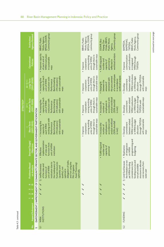
88 River Basin Management Planning in Indonesia: Policy and Practice
No.
Asp
ect/
Suba
spec
t1 A
2 B3 C
4 DPr
oble
ms B
ased
on
Ana
lysis
Des
ired
Targ
et/
Obj
ectiv
e
STRA
TEG
Y
Ope
ratio
nal
Polic
ies
Inst
itutio
n/A
genc
y Re
late
d
iSh
ort T
erm
(2
011-
2015
)
ii +
iM
ediu
m T
erm
(2
011-
2020
)
iii +
ii +
iLo
ng T
erm
(2
011-
2030
)
5EM
POW
ERM
ENT
/ IM
PRO
VEM
ENT
OF
COM
MU
NIT
Y, P
RIVA
TE S
ECTO
R, A
ND
GO
VERN
MEN
T PA
RTIC
IPAT
ION
5.1
WRM
IN
STIT
UTI
ON
S
1) I
neffe
ctiv
enes
s of
the
role
s and
fu
nctio
ns o
f un
it of
WRM
in
stitu
tion
due
to
the
inad
equa
cy o
f hu
man
reso
urce
s (q
uant
ity a
nd
qual
ity),
not
optim
al in
de
lega
tion
of ta
sks,
and
not u
sing t
he
PAI (
Irrig
atio
n A
sset
Fin
anci
ng)
optim
ally.
• �Eff
ective �
impl
emen
tatio
n of
role
s and
fu
nctio
n fro
m
unit
of W
RM
inst
itutio
n
• �Increasin
g �the�
capa
city
of
each
WRM
w
orki
ng u
nit w
ith
Perfo
rman
ce
Benc
hmar
king
(1
4 in
dica
tors
) w
ith su
stai
nabl
e w
ays
• �Increasin
g �the�
capa
city
of e
ach
unit
of W
RM
inst
itutio
n w
ith
Perfo
rman
ce
Benc
hmar
king
(1
4 in
dica
tors
) w
ith su
stai
nabl
e w
ays
• �Increasin
g �the�
capa
city
of e
ach
unit
of W
RM
inst
itutio
n w
ith
Perfo
rman
ce
Benc
hmar
king
(1
4 in
dica
tors
) w
ith su
stai
nabl
e w
ays
• �Im
prove �capacity�
of e
ach
unit
of
WRM
inst
itutio
n in
sust
aina
ble
way
s
BBW
S, P
ublic
W
orks
Age
ncy,
BPSD
A, D
GW
R,
Com
mun
ity gr
oup
• �Im
prove �
coop
erat
ion
amon
g wor
king
un
its o
f WRM
th
roug
h M
oU in
su
stai
nabl
e w
ays
• �Im
prove �
coop
erat
ion
amon
g wor
king
un
its o
f WRM
th
roug
h M
oU in
su
stai
nabl
e w
ays
• �Im
prove �
coop
erat
ion
amon
g wor
king
un
its o
f WRM
th
roug
h M
oU in
su
stai
nabl
e w
ays
• �Im
prove �
coop
erat
ion
amon
g wor
king
un
its o
f WRM
th
roug
h M
oU in
su
stai
nabl
e w
ays
BBW
S, P
ublic
W
orks
Age
ncy,
BPSD
A, D
GW
R,
com
mun
ity gr
oup
• �Fulfill �required�
num
ber a
nd
capa
city
of
pers
onne
l
• �Increase�the�
num
ber o
f em
ploy
ees i
n ac
cord
ance
with
an
alys
t wor
kloa
d (5
0% sh
ortfa
ll is
met
)
• �Increase�the�
num
ber o
f em
ploy
ees i
n ac
cord
ance
with
an
alys
t wor
kloa
d (5
0% sh
ortfa
ll is
met
)
• �Keeping�fi
t�be
twee
n th
e am
ount
of
retir
emen
t with
th
e pro
cure
men
t of
a ne
w em
ploy
ee
in ac
cord
ance
wo
rklo
ad an
alysis
• �Fulfill�required�
num
ber a
nd
capa
city
of
pers
onne
l as
refle
cted
in
wor
kloa
d an
alys
is
DG
WR,
Biro
Ke
peg.
Dan
O
rtala
, BBW
S,
Publ
ic W
orks
A
genc
y, Co
mm
unity
grou
p
5.2
FUN
DIN
G
1)
Lim
it fu
nd b
ecau
se
the l
imita
tion
or n
ot
yet W
RM fu
ndin
g co
mm
itmen
t, lim
it fu
ndin
g sou
rces
and
not y
et av
ailab
le
stru
ctur
e to
alloc
ate
cost
reco
very
from
wa
ter u
ser
• �Re
aliza
tion�
of in
t egr
atio
n on
WRM
pr
ogra
mm
ing a
nd
budg
etin
g
• �Develop�
com
mitm
ent
betw
een
rela
ted
W
RM in
stitu
tions
in
WRM
bud
get
allo
catio
n th
roug
h TK
PSD
A
with
sust
aina
ble
way
s
• �Develop�
com
mitm
ent
betw
een
rela
ted
WRM
inst
itutio
ns
in W
RM b
udge
t al
loca
tion
thro
ugh
TKPS
DA
with
su
stai
nabl
e w
ays
• �Develop�
com
mitm
ent
betw
een
rela
ted
W
RM in
stitu
tions
in
WRM
bud
get
allo
catio
n th
roug
h TK
PSD
A
with
sust
aina
ble
way
s
• �Im
prove�
com
mun
ica t
ion
and
coor
dina
tion
in in
tegr
ated
W
RM th
roug
h TK
PSD
A
BAPP
EDA
, BA
PPEN
AS,
TK
PSD
A,
BBW
S, P
ublic
W
orks
Age
ncy,
Com
mun
ity gr
oup
cont
inue
d on
nex
t pag
e
Tabl
e 4.3
con
tinue
d

Basin Planning Required in Indonesia 89
No.
Asp
ect/
Suba
spec
t1 A
2 B3 C
4 DPr
oble
ms B
ased
on
Ana
lysis
Des
ired
Targ
et/
Obj
ectiv
e
STRA
TEG
Y
Ope
ratio
nal
Polic
ies
Inst
itutio
n/A
genc
y Re
late
d
iSh
ort T
erm
(2
011-
2015
)
ii +
iM
ediu
m T
erm
(2
011-
2020
)
iii +
ii +
iLo
ng T
erm
(2
011-
2030
)
• �Re
aliza
tion �of�
serv
ice
fee
of
WRM
• �Re
view
�and�se
t�up
serv
ice
fee
colle
ctio
n
of W
RM
• �Set�u
p�service�
fe
e c o
llect
ion
of
WRM
• �App
lying�service�
fee
colle
ctio
n
of W
RM
• �Re
view
,�set�up,�
and
appl
y ser
vice
fe
e co
llect
ion
of
WRM
BLU
, DG
WR,
BB
WS,
Pub
lic
Wor
ks A
genc
y, D
G-B
LU,
MoF
, Men
PU
, Co
mm
unity
grou
p
• �BL
U�form
ation�
of
WRM
• �Re
view
,�di
scus
sion
and
set u
p BL
U o
f W
RM
• �Operatio
n�and�
mon
itorin
g BLU
of
WRM
with
su
stai
nabl
e w
ays
• �Operatio
n�and�
mon
itorin
g BLU
of
WRM
with
su
stai
nabl
e w
ays
• �Re
view
,�set�up,�
and
O&
M B
LU o
f W
RM
DG
WR,
BBW
S,
Publ
ic W
ork
Age
ncy,
DG
-BLU
, M
oF, M
PU,
Com
mun
ity gr
oup
5.3
GO
VERN
AN
CE
1)
Not
max
imal
eff
orts
from
go
vern
men
t to
con
trol t
he
grou
ndw
ater
ab
stra
ctio
n do
ne
by a
priv
ate/
com
pany
/indu
stry
• �Co
ntrol �on�
grou
ndw
ater
ab
stra
ctio
n
• �Im
plem
ent�
inve
ntor
y all
grou
ndw
ater
w
ells
and
deve
lop
mon
itorin
g wel
ls on
pro
ne lo
catio
n
• �Monito
r, �observe,�
and
cond
uct l
aw
enfo
rcem
ent w
ith
sust
aina
ble
way
s (n
o-pe
rmitt
ed
abst
ract
ion,
or
exce
eds v
olum
e lic
ense
)
• �Monito
r, �observe,�
and
cond
uct l
aw
enfo
rcem
ent w
ith
sust
aina
ble
way
s (n
o-pe
rmitt
ed
abst
ract
ion,
or
exce
eds v
olum
e lic
ense
)
• �Inventory �
and
mon
itor
grou
ndw
ater
ab
stra
ctio
n as
pe
rmit
issue
d
Prov
inci
al B
PLH
D,
Prov
inci
al E
MR
agen
cy, R
egen
t M
inin
g & W
RM
Age
ncy,
BBW
S,
Satp
ol P
P, P
olic
e,
Com
mun
ity gr
oup
• �Increased �
awar
enes
s fro
m
priv
ate/
com
pany
/in
dust
ry o
n gr
ound
wat
er
abst
ract
ion
• �Im
plem
ent�
soci
aliza
tion
and
publ
ic
awar
enes
s abo
ut
the
grou
ndw
ater
ab
stra
ctio
n w
ith
sust
aina
ble
way
s
• �Im
plem
ent�
soci
aliza
tion
and
publ
ic
awar
enes
s abo
ut
the
grou
ndw
ater
ab
stra
ctio
n w
ith
sust
aina
ble
way
s
• �Im
plem
ent�
soci
aliza
tion
and
publ
ic
awar
enes
s abo
ut
the
grou
ndw
ater
ab
stra
ctio
n w
ith
sust
aina
ble
way
s
• �Im
plem
ent�
soci
aliza
tion
and
publ
ic aw
aren
ess
on d
eep
grou
ndw
ater
ab
stra
ctio
n
BPLH
D p
rov.,
ka
b/ko
ta, D
inas
ES
DM
Pro
v.,
Din
as S
DA
dan
Pe
rtam
bang
an
Kab/
Kota
, BBW
S,
Kelo
mpo
k M
asya
raka
t
2)
No
dele
gatio
n of
per
mitt
ing o
n su
rface
wat
er
utiliz
atio
n an
d co
mm
erci
aliza
tion
from
Min
ister
of
PU to
Gov
erno
r
• �Issuance�the�
dele
gatio
n of
pe
rmitt
ing o
n su
rface
wat
er
utiliz
atio
n an
d co
mm
ercia
lizat
ion
• �Draft�and�issued�
the d
eleg
atio
n of
per
mitt
ing o
n su
rface
wat
er
utiliz
atio
n an
d co
mm
ercia
lizat
ion
• �Implem
ent�the�
rule
s of p
erm
ittin
g on
surfa
ce w
ater
ut
ilizat
ion
and
com
mer
cializ
atio
n
• �Implem
ent�the�
rule
s of p
erm
ittin
g on
surfa
ce w
ater
ut
ilizat
ion
and
com
mer
cializ
atio
n
• �Implem
ent�
dele
gatio
n of
pe
rmitt
ing o
n su
rface
wat
er
utiliz
atio
n an
d co
mm
ercia
lizat
ion
from
Min
ister
of
PU to
Gov
erno
r
MPU
, Gov
erno
r, Pr
ovin
cial
W
RM a
genc
y, BB
WS,
BPS
DA
, Co
mm
unity
grou
p
3) a
nd so
forth
….
Tabl
e 4.3
con
tinue
d
cont
inue
d on
nex
t pag
e

90 River Basin Management Planning in Indonesia: Policy and Practice
No.
Asp
ect/
Suba
spec
t1 A
2 B3 C
4 DPr
oble
ms B
ased
on
Ana
lysis
Des
ired
Targ
et/
Obj
ectiv
e
STRA
TEG
Y
Ope
ratio
nal
Polic
ies
Inst
itutio
n/A
genc
y Re
late
d
iSh
ort T
erm
(2
011-
2015
)
ii +
iM
ediu
m T
erm
(2
011-
2020
)
iii +
ii +
iLo
ng T
erm
(2
011-
2030
)
5.4
COO
RDIN
ATIO
N
FORU
M F
OR
WRM
1) N
ot o
ptim
al
perfo
rman
ce
of P
rovi
ncia
l an
d D
istric
t (K
abup
aten
/Ko
ta) I
rriga
tion
Com
miss
ion
• �Optimize
�pe
rform
ance
fro
m th
e ac
tive
Prov
inci
al
and
Dist
rict
(Kab
upat
en/
Kota
) Irri
gatio
n Co
mm
issio
n
• �Establish
�an
d ac
tivat
e Pr
ovin
cial
an
d D
istric
t (K
abup
aten
/Ko
ta) I
rriga
tion
Com
miss
ion
• �Activate�and�
faci
litat
e Pr
ovin
cial
an
d D
istric
t (K
abup
aten
/Ko
ta) I
rriga
tion
Com
miss
ion
• �Activate�and�
faci
litat
e Pr
ovin
cial
an
d D
istric
t (K
abup
aten
/Ko
ta) I
rriga
tion
Com
miss
ion
• �Establish
,�ac
tivat
e, a
nd
faci
litat
e Pr
ovin
cial
an
d D
istric
t (K
abup
aten
/Ko
ta) I
rriga
tion
Com
miss
ion
Prov
inci
al
WRM
Age
ncy,
BAPP
EDA
, Pr
ovin
cial
A
gric
ultu
re
agen
cy, B
BWS,
BP
SDA
, Co
mm
unity
grou
p
2) N
ot o
ptim
al
perfo
rman
ce o
f Pr
ovin
cial
Wat
er
Reso
urce
Cou
ncil
• �Optimize
�pe
rform
ance
fro
m a
ctiv
e Pr
ovin
cial
Wat
er
Reso
urce
Cou
ncil
• �Optimize
�pe
rform
ance
of
Prov
inci
al W
ater
Re
sour
ce C
ounc
il in
sust
aina
ble
way
s
• �Optimize
�pe
rform
ance
of
Prov
inci
al W
ater
Re
sour
ce C
ounc
il in
sust
aina
ble
way
s
• �Optimize
�pe
rform
ance
of
Prov
inci
al W
ater
Re
sour
ce C
ounc
il in
sust
aina
ble
way
s
• �Optimize
�pe
rform
ance
of
Prov
inci
al W
ater
Re
sour
ce C
ounc
il in
sust
aina
ble
way
s
Prov
inci
al W
RM
agen
cy, P
rovi
ncia
l BA
PPED
A,
Secr
etar
iat
of P
rovi
ncia
l W
R Co
unci
l, Co
mm
unity
grou
p
3)
and
so fo
rth….
5.5
EMPO
WER
MEN
T AN
D IM
PRO
VEM
ENT
OF C
OM
MUN
ITY
AND
PRIV
ATE
SECT
OR
PART
ICIP
ATIO
N
1) W
eakn
ess o
n em
pow
erm
ent
and
impr
ovem
ent
of c
omm
unity
in
WRM
• �Increased�
awar
enes
s and
ca
paci
ty o
f co
mm
unity
in
WRM
• �Im
plem
ent�
soci
aliza
tion,
pu
blic
awar
enes
s ca
mpa
ign
on
WRM
• �Im
plem
ent�
soci
aliza
tion,
pu
blic
awar
enes
s ca
mpa
ign
on
WRM
• �Im
plem
ent�
soci
aliza
tion,
pu
blic
awar
enes
s ca
mpa
ign
on
WRM
• �Im
plem
ent�
soci
aliza
tion,
pu
blic
awar
enes
s ca
mpa
ign
on
WRM
TKPS
DA
, For
um
DAS
, BP
DAS
, BB
WS,
Din
as
PU/S
DA
dan
Pem
uka a
gam
a/to
koh
mas
yara
kat,
Kelo
mpo
k M
asya
raka
t,Dikn
as
• �Im
plem
ent�
capa
city
bui
ldin
g of
farm
ers/
WU
As
in m
anag
ing
terti
ary i
rriga
tion
netw
ork (
30%
ar
ea)
• �Im
plem
ent�
capa
city
bui
ldin
g of
farm
ers/
WU
As
in m
anag
ing
terti
ary i
rriga
tion
netw
ork (
20%
ar
ea, c
umul
ativ
e 50
% a
rea)
• �Im
plem
ent�
capa
city
bui
ldin
g of
farm
ers/
WU
As
in m
anag
ing
terti
ary i
rriga
tion
netw
ork (
50%
ar
ea, c
umul
ativ
e 10
0% a
rea)
• �Im
prove�
awar
enes
s and
ca
paci
ty o
f fa
rmer
s/W
UA
s in
man
agin
g te
rtiar
y irri
gatio
n ne
twor
k
Agr
icul
ture
ag
ency
, BBW
S,
WRM
Age
ncy,
WU
As,
Com
mun
ity gr
oup
cont
inue
d on
nex
t pag
e
Tabl
e 4.3
con
tinue
d
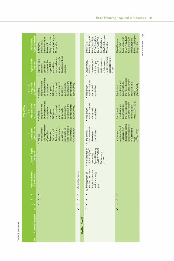
Basin Planning Required in Indonesia 91
No.
Asp
ect/
Suba
spec
t1 A
2 B3 C
4 DPr
oble
ms B
ased
on
Ana
lysis
Des
ired
Targ
et/
Obj
ectiv
e
STRA
TEG
Y
Ope
ratio
nal
Polic
ies
Inst
itutio
n/A
genc
y Re
late
d
iSh
ort T
erm
(2
011-
2015
)
ii +
iM
ediu
m T
erm
(2
011-
2020
)
iii +
ii +
iLo
ng T
erm
(2
011-
2030
)
• �Welfare�
empo
wer
men
t an
d im
prov
emen
t of
peo
ple
in
the
uppe
r D
AS
arou
nd
the
fore
st a
nd
wat
er so
urce
s, to
act
ivel
y pa
rtici
pate
to
keep
fore
st a
nd
envi
ronm
enta
l su
stai
nabi
lity.
• �Welfare�
empo
wer
men
t an
d im
prov
emen
t of
peo
ple
in
the
uppe
r D
AS
arou
nd
the
fore
st a
nd
wat
er so
urce
s, to
act
ivel
y pa
rtici
pate
to
keep
fore
st a
nd
envi
ronm
enta
l su
stai
nabi
lity.
• �Welfare�
empo
wer
men
t an
d im
prov
emen
t of
peo
ple
in
the
uppe
r D
AS
arou
nd
the
fore
st a
nd
wat
er so
urce
s, to
act
ivel
y pa
rtici
pate
to
keep
fore
st a
nd
envi
ronm
enta
l su
stai
nabi
lity.
• �Im
prove �social�
econ
omic
co
nditi
on o
f pe
ople
in th
e up
per D
AS
arou
nd th
e fo
rest
and
wat
er
sour
ces t
hrou
gh
deve
lopm
ent a
nd
advi
sory
BAPP
EDA
, D
inas
Sos
ial,
Din
as P
erta
nian
, Ke
lom
pok
Mas
yara
kat d
an
swas
ta, K
elom
pok
Mas
yara
kat
2) a
nd so
forth
….
SPAT
IAL
PLA
NS
1) I
nfrin
gem
ent o
f th
e la
nd u
se th
at is
no
t in
acco
rdan
ce
with
the
zoni
ng
plan
• �Im
plem
entatio
n �of
Law
26/
2007
co
ncer
ning
Sp
atia
l Pla
nnin
g an
d PP
26/
2008
Co
ncer
ning
RT
RW
• �Im
plem
ent �
soci
aliza
tion
on
the
rela
ted
sp
atia
l law
s
• �Im
plem
ent�
soci
aliza
tion
on
the
rela
ted
sp
atia
l law
s
• �Im
plem
ent�
soci
aliza
tion
on
the
rela
ted
sp
atia
l law
s
• �Dissem
inate,�
mon
itor,
supe
rvise
, and
en
forc
e up
on
viol
atio
ns o
f sp
atia
l law
s and
re
gula
tions
as
wel
l as p
rovi
ncia
l/ka
bupa
ten/
kota
RT
RW
Din
as T
ata
Ruan
g Pro
v/ K
ab/
Kota
, Din
as P
U/
PSD
A P
rov./
Kab/
Kota
, BA
PPED
A
Prov
/Kab
/Kot
a,
BBW
S, K
elom
pok
Mas
yara
kat
• �Im
plem
ent�
mon
itorin
g and
su
perv
ision
on
the
rela
ted
spat
ial
law
s enf
ocem
ent
in su
stai
nabl
e w
ays
(201
4-20
15)
• �Im
plem
ent�
mon
itorin
g and
su
perv
ision
on
the
rela
ted
spat
ial
law
s enf
ocem
ent
in su
stai
nabl
e w
ays (
2014
-201
5)
• �Im
plem
ent�
mon
itorin
g and
su
perv
ision
on
the
rela
ted
spat
ial
law
s enf
ocem
ent
in su
stai
nabl
e w
ays
(201
4-20
15)
Din
as K
imru
m
Prov
/ Kab
/Ko
ta, D
inas
PU
/PS
DA
Pro
v./Ka
b/Ko
ta, B
APP
EDA
Pr
ov/K
ab/K
ota,
BB
WS,
Kel
ompo
k M
asya
raka
t
Tabl
e 4.3
con
tinue
d
cont
inue
d on
nex
t pag
e

92 River Basin Management Planning in Indonesia: Policy and Practice
No.
Asp
ect/
Suba
spec
t1 A
2 B3 C
4 DPr
oble
ms B
ased
on
Ana
lysis
Des
ired
Targ
et/
Obj
ectiv
e
STRA
TEG
Y
Ope
ratio
nal
Polic
ies
Inst
itutio
n/A
genc
y Re
late
d
iSh
ort T
erm
(2
011-
2015
)
ii +
iM
ediu
m T
erm
(2
011-
2020
)
iii +
ii +
iLo
ng T
erm
(2
011-
2030
)
• �Im
plem
entatio
n �of
Law
32/
2009
co
ncer
ning
En
viro
nmen
tal
Prot
ectio
n an
d M
anag
emen
t
• �Set�u
p�water�
zoni
ng u
tiliza
tion
incl
udin
g c a
tchm
ent a
reas
, w
ater
cat
chm
ent,
wat
er so
urce
s in
to p
rovi
ncia
l/di
stric
t/city
sp
atia
l pla
n
• �Im
plem
ent �
mon
itorin
g and
su
perv
ise th
e im
plem
ent a
tion
of th
e sp
atia
l pl
an, li
miti
ng th
e de
signa
tion
of th
e ar
ea b
y lim
iting
th
e lo
catio
n pe
rmit,
bui
ldin
g pe
rmit,
bui
ldin
g co
de, a
s wel
l as
the
cons
olid
atio
n of
land
hold
ings
flo
od re
tent
ion
• �Im
plem
ent �
mon
itorin
g and
su
perv
ise th
e im
plem
ent a
tion
of th
e sp
atia
l pl
an, li
miti
ng
the
desig
natio
n of
the
area
by
limiti
ng th
e lo
catio
n pe
rmit,
bu
ildin
g per
mit,
bu
ildin
g cod
e,
as w
ell a
s the
co
nsol
idat
ion
of la
ndho
ldin
gs
flood
rete
ntio
n
Din
as K
imru
m
Prov
/ Kab
/Kot
a,
Din
as P
U/P
SDA
Pr
ov./K
ab/K
ota,
BA
PPED
A P
rov/
Kab/
Kota
, BPN
, BB
WS,
Kel
ompo
k M
asya
raka
t
• �Establish
�zones�
tsun
ami-p
rone
ar
eas ,
flood
-pr
one,
land
slide
pr
one,
in th
e pr
ovin
cial
/ di
stric
ty/ c
ity
spat
ial p
lan.
Bala
i PSD
A =
BPS
DA
= P
rovi
ncia
l WRM
Cen
ter f
or C
itaru
m, B
APP
EDA
= P
rovi
ncia
l and
Dist
rict/C
ity P
lann
ing B
urea
u, B
APP
ENA
S =
Nat
iona
l Pla
nnin
g Bur
eau,
BBW
S =
Nat
iona
l Ba
sin W
RM C
ente
r for
Cita
rum
, Biro
Kep
eg d
an O
rtala
= B
urea
u of
Hum
an R
esou
rces
and
Gen
eral
Affa
irs, B
LU =
Pub
lic S
ervic
es B
oard
, BM
KG =
Indo
nesia
n In
stitu
te fo
r Met
eoro
logy
, Cl
imat
olog
y, an
d G
eoph
ysic
s, BN
PB /
BPBD
= N
atio
nal /
Reg
iona
l Disa
ster
Miti
gatio
n Bo
ard,
BPL
HD
= E
MR
= En
viro
nmen
tal M
anag
emen
t Boa
rd, B
PN =
Nat
iona
l Lan
d Re
gist
ratio
n Bo
ard,
BPD
AS
= W
ater
shed
man
agem
ent c
ente
r (M
in o
f For
estry
and
Env
ironm
ent)
, CAT
– gr
ound
wat
er b
asin
, DEM
= D
igita
l Ele
vatio
n M
odel
, DM
I = D
omes
tic,
Mun
icip
al a
nd In
dust
rial (
wat
er u
se),
Din
as K
imru
m =
Age
ncy f
or H
uman
Set
tlem
ents
and
Hou
sing,
Din
as T
ata
Ruan
g = A
genc
y for
Spa
tial P
lann
ing,
DM
I = D
omes
tic, M
unic
ipal
an
d In
dust
rial W
ater
Use
, EM
R =
Envi
ronm
enta
l Man
agem
ent B
oard
, ESD
M =
Age
ncy f
or E
nerg
y and
Min
eral
Res
ourc
es (i
ncl. G
roun
d W
ater
), Ke
lom
pok M
asya
raka
t = c
omm
unity
or
gani
zatio
n, G
IS =
Geo
grap
hica
l Inf
orm
atio
n Sy
stem
, MO
U =
Mem
oran
dum
of U
nder
stan
ding
, MPU
= M
inist
ry o
f Pub
lic W
orks
, O&
M =
ope
ratio
n an
d m
aint
enan
ce,
PAI =
Irrig
atio
n A
sset
Man
agem
ent s
yste
m, P
erta
nian
= A
gric
ultu
re, P
JT II
= W
RM B
oard
for C
itaru
m B
asin
, fun
ctio
ns b
esid
es B
BWS
and
Bala
i PSD
A, P
LN =
Ele
ctric
ity B
oard
, RT
kRH
L =
Tech
nica
l Pla
n fo
r Reh
abilit
atio
n of
For
est a
nd L
and,
Sw
asta
= p
rivat
e se
ctor
, TKP
SDA
= B
asin
WRM
Cou
ncil,
WRM
= W
ater
Res
ourc
es M
anag
emen
t, W
RMIS
= W
RM
Info
rmat
ion
Syst
em, W
S =
Rive
r Bas
in T
errit
ory,
WU
A =
Wat
er U
sers
Ass
ocia
tion.
Sour
ce: D
raft
Pola
for W
S Ci
taru
m (2
013)
.
Tabl
e 4.3
con
tinue
d
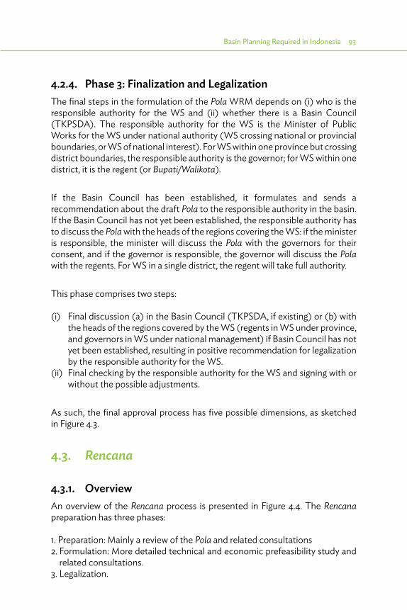
Basin Planning Required in Indonesia 93
4.2.4. Phase 3: Finalization and LegalizationThe final steps in the formulation of the Pola WRM depends on (i) who is the responsible authority for the WS and (ii) whether there is a Basin Council (TKPSDA). The responsible authority for the WS is the Minister of Public Works for the WS under national authority (WS crossing national or provincial boundaries, or WS of national interest). For WS within one province but crossing district boundaries, the responsible authority is the governor; for WS within one district, it is the regent (or Bupati/Walikota).
If the Basin Council has been established, it formulates and sends a recommendation about the draft Pola to the responsible authority in the basin. If the Basin Council has not yet been established, the responsible authority has to discuss the Pola with the heads of the regions covering the WS: if the minister is responsible, the minister will discuss the Pola with the governors for their consent, and if the governor is responsible, the governor will discuss the Pola with the regents. For WS in a single district, the regent will take full authority.
This phase comprises two steps:
(i) Final discussion (a) in the Basin Council (TKPSDA, if existing) or (b) with the heads of the regions covered by the WS (regents in WS under province, and governors in WS under national management) if Basin Council has not yet been established, resulting in positive recommendation for legalization by the responsible authority for the WS.
(ii) Final checking by the responsible authority for the WS and signing with or without the possible adjustments.
As such, the final approval process has five possible dimensions, as sketched in Figure 4.3.
4.3. Rencana
4.3.1. OverviewAn overview of the Rencana process is presented in Figure 4.4. The Rencana preparation has three phases:
1. Preparation: Mainly a review of the Pola and related consultations2. Formulation: More detailed technical and economic prefeasibility study and
related consultations.3. Legalization.
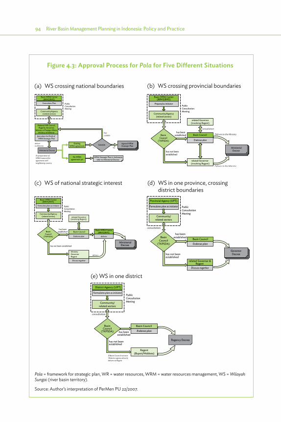
94 River Basin Management Planning in Indonesia: Policy and Practice
PublicConsultationMeeting
Basin WRM Center(BBWS/BWS)
Formulates Plan
Community/Agency(related sectors)
deliverto Ministry
Agreed WRMStrategic Plan
National WR Council,Regents, Governor,
Ministry of Foreign A�airs,Ministry of Defense
No WRMagreement yet
formulate the Draft of WRM Strategic Plan
Ministerial Decree
As preparation ofWRM material foragreement withneighboring country
ExistingWRM agreement Suitable
WRM Strategic Plan in Indonesiarefer to Ministerial Decree
Notsuitable
Yes
has beenestablished
has not beenestablished
PublicConsultationMeeting
Basin WRM Center(BBWS/BWS)
Prepare/as initiator
Community/Agency(related sectors)
Basin Council
MinisterialDecree
Delivers to the Ministry
related Governor (involving Regent)
related Governor(involving Regent)
Endorses plan
consultation
Delivers to the Ministry
BasinCouncil
(TKPSDA)
has beenestablished
has not been established
PublicConsultationMeeting
MinisterialDecree
BasinCouncil
(TKPSDA)
Basin WRM Center(BBWS/BWS)
related Governor(involving Regent)
Formulate plan as initiator
Community/Agency(related sectors)
Basin Council
- Ministry- Governor- Regent
Endorses plan
delivers
Basin WRM Center(BBWS/BWS)
delivers
Discuss together
Provincial Agency (UPT)
Formulates plan as initiator
Community/related sectors
consultation
related Governor &Regent
Discuss together
Basin Council
Endorses plan
has beenestablished
has not been established
BasinCouncil
(TKPSDA)
PublicConsultationMeeting
GovernorDecree
(a) WS crossing national boundaries (b) WS crossing provincial boundaries
(c) WS of national strategic interest (d) WS in one province, crossing district boundaries
District Agency (UPT)
Formulates plan as initiator
Community/related sectors
consultation
Regent(Bupati/Walikota)
Regency Decree
If Basin Council not exist�district agency directlydelivers to Regent
PublicConsultationMeeting
has beenestablished
has not beenestablished
Basin Council
Endorses plan
BasinCouncil
(TKPSDA)
(e) WS in one district
Figure 4.3: Approval Process for Pola for Five Different Situations
Pola = framework for strategic plan, WR = water resources, WRM = water resources management, WS = Wilayah Sungai (river basin territory).
Source: Author’s interpretation of PerMen PU 22/2007.
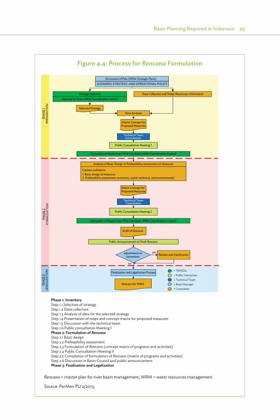
Basin Planning Required in Indonesia 95
Figure 4.4: Process for Rencana Formulation
PHA
SE 2
FORM
ULA
TIO
NPH
ASE
3LE
GA
LIZA
TIO
NPH
ASE
1PR
EPA
RATI
ON
Document of Pola (WRM Strategic Plans)
SCENARIO, STRATEGY, AND OPERATIONAL POLICY
Strategy Selection
Selected by Basin WRM Coordination Council
Data Collection and Water Resources Information
Selected StrategyData Analysis
Matrix Concept forProposed Measures
Technical TeamConsultation
Public Consultation Meeting 1
Public Consultation Meeting 2
Discussion of Result from PKM 1 by Basin WRM Coordination Council
Analysis of Basic Design of Prefeasibility Assessment of Measures
Content substance1. Basic design of measures2. Prefeasibility assessment: economic, social, technical, and environmental
Matrix Concept forProposed Measures
Technical TeamConsultation
Discussion of Result from PKM 2 by Basin WRM Coordination Council
Draft of Rencana
Review and Clarification
Public Announcement of Draft Rencana
adjustments orcorrections
Finalization and Legalization Process
Rencana for WRM
yes
no
= TKPSDA= Public Interaction= Technical Team= Basin Manager= Consultant
Phase 1: InventoryStep 1.1 Selection of strategyStep 1.2 Data collectionStep 1.3 Analysis of data for the selected strategyStep 1.4 Presentation of maps and concept matrix for proposed measuresStep 1.5 Discussion with the technical teamStep 1.6 Public consultation Meeting IPhase 2: Formulation of RencanaStep 2.1 Basic designStep 2.2 Prefeasibility assessmentStep 2.3 Formulation of Rencana (concept matrix of programs and activities)Step 2.4 Public Consultation Meeting IIStep 2.5 Completion of formulation of Rencana (matrix of programs and activities)Step 2.6 Discussion in Basin Council and public announcementPhase 3: Finalization and Legalization
Rencana = master plan for river basin management, WRM = water resources management.
Source: PerMen PU 2/2013.

96 River Basin Management Planning in Indonesia: Policy and Practice
A more elaborate description of the activities done for each step is given in the next sections.
4.3.2. Phase 1: InventoryStep 1.1 Selection of strategy is done by the Basin Council. If the Basin Council is not formed yet, it will be done by the responsible authority for the basin as discussed above. In principle, the Pola has proposed 3–5 main strategies for the basin, as explained in Box 4.4, based on different scenarios, as explained in Box 4.3. The selected strategy is usually one of these proposed main strategies, or a slightly adapted one if the competent authority wishes so.
The selection of the main strategy is basically the completion of the Pola. The Pola defines in the operational policies (kebijakan operational) specific strategies for each problem identified, with a target to improve the WRM conditions. These strategies are all linked to the 3-5 main strategies. In selecting the main strategy, the specific strategies to address each problem are also selected, leaving out the ones not included in the selected main strategy. With this activity of “selection of the strategy,” the Pola matrix of operational policies is developed into a list of strategies, for which specific measures are identified and further analyzed in the subsequent steps of Rencana formulation.
Step 1.2 Data collection focuses on the following subjects, according to PerMen 2/2013:
(i) Quantity and quality of water resources(ii) Present natural conditions and potential development(iii) Location and capacity of sources and infrastructure(iv) Institutions relevant for the WS(v) Socioeconomic conditions
An important component of this step is the identification of measures to support each specific strategy selected from the Pola matrix of operational policies as indicated above. For each strategy, there should be at least one measure, but there can also be more.
Most activities in this step comprise a review and update of the data collected under the Pola (Section 4.2.2 and Box 4.1), because normally there is only a gap of 1 or 2 years between finalization of the Pola and start of the Rencana.
Step 1.3 Analysis of data for the selected strategy is mostly a review and update of the data analyzed for the Pola, with focus on the subjects related to the five pillars of Law 7/2004 (Section 4.2.3 and Table 4.2).

Basin Planning Required in Indonesia 97
Step 1.4 Presentation of maps and concept matrix for proposed measures comprises preparation of a presentation for Public Consultation Meeting I based on the data analyzed under Step 1.3. Focus is on maps illustrating the issues concerning conservation, utilization, and disaster management, and an overview of proposed measures in a matrix according to the five pillars of Law 7/2004. An example of such a matrix is given in Table 4.4. The matrix should show for each strategy and subaspect the following data at least:
(i) Target(ii) One or more specific measures(iii) Location (in catchment and in administrative areas) for each measure
Step 1.5 Discussion with the technical team, comprising senior water resources specialists from among present or former DGWR staff, which is called for meetings to review the proposed Pola and Rencana.
Step 1.6 Public Consultation Meeting I is implemented as Step 1.5 for the Pola (Section 4.2.2 and Table 4.1). Here the following items are discussed:
(i) Strategy selected by Basin Council(ii) Proposed WRM in the basin(iii) Results of data collection and data analysis(iv) Maps concerning zones for infiltration, water retention, and water utilization(v) Material prepared under Step 1.4 for the Rencana
PerMen 2/2013 indicates the same participants as already mentioned in Table 4.1, but adds agencies on Industry (for licensing groundwater and surface water use) and the Disaster Management Board.
Participatory inventory of data and mapping.

98 River Basin Management Planning in Indonesia: Policy and Practice
Tabl
e 4.
4: C
once
pt M
atrix
for P
ropo
sed
Mea
sure
s
No.
Aspe
ct/
SubA
spec
tSe
lect
ed
Stra
tegy
Mea
sure
sLo
catio
nTy
peD
imen
sions
Out
com
eEs
timat
ed C
ost
(Rp
mill
ion)
Estim
ated
Elig
ibili
ty
Tim
e Fr
ame
Exec
utin
g A
genc
y1
23
45
5-10
year
s10
-20
year
s
Non
phys
ical
Phys
ical
Dist
rict/
City
Wat
ersh
eds
Non
phys
ical
Phys
ical
Econ
omic
Envir
onm
enta
lSo
cial
2011
2012
2013
2014
2015
1CO
NSE
RVAT
ION
1-1
WAT
ER R
ESO
URC
ES
PRO
TECT
ION
AN
D
SUST
AIN
ING
1-1-
1Pr
otec
ting
and
incr
easin
g ca
tchm
ent
area
s in
the
uppe
r and
m
iddl
e of
w
ater
shed
1. A
rrang
e an
d se
t up
the
Perd
a of
Re
gent
/City
co
ncer
ning
zo
ning
ca
tchm
ent
area
, as w
ell
as b
uild
ing
code
s and
Ko
efisia
n D
asar
Ba
ngun
an
(KD
B) in
ca
tchm
ent
area
Kab.
: Ba
ndun
g, Ba
ndun
g Ba
rat,
Beka
si,
Cian
jur,
Indr
amay
u,
Kara
wan
g, Pu
rwak
arta
, Su
bang
, Su
med
ang.
Kota
: Ba
ndun
g, Ci
mah
i, Be
kasi
Cita
rum
, Se
dari,
Ci
saga
, Ci
bada
r dua
, Ci
bada
k, Ci
karo
krok
, Ci
bant
eng,
Cim
alay
a,
Cige
mar
i, Ci
asem
, Ba
tang
leut
ik,
Cire
ungi
t, Ci
rand
u,
Cipu
nega
ra,
Sew
o,
Suka
maj
u,
Buge
l, Ci
boda
s, Ci
dong
kol
Perd
a Ka
b/Ko
ta1 P
erda
6,10
0 in
tang
ible
be
nefit
com
ply
supp
orte
d by
soci
ety
Spat
ial P
lan
Age
ncy,
Perm
it A
genc
y, PU
/SD
A/
Perm
ukim
an,
BLH
D,
Kehu
tana
n,
Kom
info
Pr
ov/K
ab/
Kota
, BBW
S,
BPD
AS,
Civ
il Se
rvic
e U
nit
(sat
pol P
P),
Com
mun
ity
grou
p
2. P
ublic
aw
aren
ess
cam
paig
n an
d so
cial
izatio
n of
Per
da
conc
erni
ng
catc
hmen
t ar
ea a
nd
build
ing
code
s and
KD
B
Coun
selin
g17
year
s
3. C
ontro
l bu
ildin
g pe
rmits
(I
MB)
4. P
rote
ct
the
uppe
r an
d m
iddl
e ca
tchm
ent
area
s at
who
le
wat
ersh
ed
cont
inue
d on
nex
t pag
e
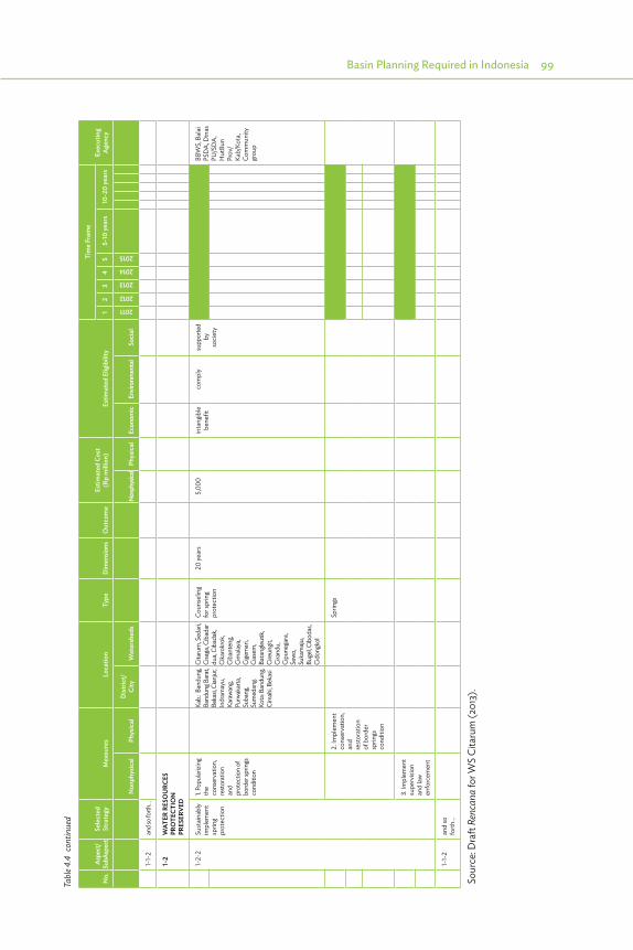
Basin Planning Required in Indonesia 99
No.
Aspe
ct/
SubA
spec
tSe
lect
ed
Stra
tegy
Mea
sure
sLo
catio
nTy
peD
imen
sions
Out
com
eEs
timat
ed C
ost
(Rp
mill
ion)
Estim
ated
Elig
ibili
ty
Tim
e Fr
ame
Exec
utin
g A
genc
y1
23
45
5-10
year
s10
-20
year
s
Non
phys
ical
Phys
ical
Dist
rict/
City
Wat
ersh
eds
Non
phys
ical
Phys
ical
Econ
omic
Envir
onm
enta
lSo
cial
2011
2012
2013
2014
2015
1-1-
2an
d so f
orth
…
1-2
WAT
ER R
ESO
URC
ES
PRO
TECT
ION
PR
ESER
VED
1-2-
2Su
stai
nabl
y im
plem
ent
sprin
g pr
otec
tion
1. Po
pular
izing
th
e co
nser
vatio
n,
rest
orat
ion
and
prot
ectio
n of
bo
rder
sprin
gs
cond
ition
Kab.:
Ban
dung
, Ba
ndun
g Bar
at,
Beka
si, C
ianju
r, In
dram
ayu,
Ka
rawa
ng,
Purw
akar
ta,
Suba
ng,
Sum
edan
g. Ko
ta: B
andu
ng,
Cim
ahi, B
ekas
i
Cita
rum
, Sed
ari,
Cisa
ga, C
ibad
ar
dua,
Ciba
dak,
Cika
rokr
ok,
Ciba
nten
g, Ci
mala
ya,
Cige
mar
i, Ci
asem
, Ba
tang
leut
ik,
Cire
ungit
, Ci
rand
u,
Cipu
nega
ra,
Sewo
, Su
kam
aju,
Buge
l, Cib
odas
, Ci
dong
kol
Coun
selin
g fo
r spr
ing
prot
ectio
n
20 ye
ars
5,00
0 in
tang
ible
be
nefit
com
ply
supp
orte
d b
y so
ciet
y
BBW
S, B
alai
PS
DA
, Din
as
PU/S
DA
, H
utBu
n Pr
ov/
Kab/
Kota
, Co
mm
unity
gr
oup
2. Im
plem
ent
cons
erva
tion,
an
d re
stor
atio
n of
bor
der
sprin
gs
cond
ition
Sprin
gs
3. Im
plem
ent
supe
rvisi
on
and
law
en
forc
emen
t
1-1-
2an
d so
fo
rth…
Sou
rce:
Dra
ft Re
ncan
a fo
r WS
Cita
rum
(201
3).
Tabl
e 4.4
con
tinue
d

100 River Basin Management Planning in Indonesia: Policy and Practice
4.3.3. Phase 2: Formulation of the RencanaThe formulation of the Rencana addresses the strategies proposed and for each strategy one or more measures are proposed.
Step 2.1 Basic design covers the dimensions of location, layout, and the principle involved for each measure, such as length of canals and dams; height of dams; and capacity of canals, pumping stations, or water treatment plans. Details on the availability of building materials in the neighborhood, location of disposal site for dumping excavated soil or borrow pit for fill material, and possible issues concerning resettlement should also be mentioned. For nonphysical measures, data on the following aspects should be specified: type of activity, location, frequency or time of implementation.
During Step 2.2 Prefeasibility assessment, the activities concentrate on the cost of the measures and, where possible, an assessment of the benefits. For this activity, the cost estimating relationships (CERs) can be used, as used for various projects, with assistance from the Dutch. The benefits are usually more difficult to assess, and in some cases where it cannot be assessed, we can compare different solutions only based on least cost. This is further discussed in Section 5.4.
An important part of this Step 2.2 is Comparison of alternative solutions. However, this is not mentioned explicitly in the PerMen. Usually, there are several options to realize proposed measures to achieve a strategy. For each option, the Rencana should indicate basic design and feasibility. Based on this analysis, the various options can be compared and a selection can be made between the different options. This specifically applies to the selection of dams: for each dam, a certain price for supply of materials per cubic meter can be calculated, and the selection will be based on least cost if no other special conditions apply (such as political sensitivity of land acquisition and resettlement). For conservation (soil conservation, water retention, water quality improvement) and flood management, cost and benefits can be specified, allowing for a more sophisticated selection.
Step 2.3 Formulation of the Rencana (concept matrix of programs and activities) will be based on the matrix for proposed measures as developed under Step 1.4 and indicated in Table 4.4. Step 2.3 will now list for each measure the following items:
(i) type of work (regulation, policy, study, construction, etc.);(ii) volume, cost;

Basin Planning Required in Indonesia 101
(iii) outcome;(iv) meeting the criteria for economic, environmental, and social feasibility;(v) timing; and(vi) institution that is responsible and other institutions that are involved.
An example page for this concept matrix is presented in Table 4.5.
Step 2.4 Discussion with the technical team, similar to Step 1.5.
Step 2.5 Public Consultation Meeting II (PKM 2) is implemented as Step 1.5 of the Rencana. During this step, the concept matrix of programs and activities is presented to the stakeholders for their comments, adjustments, and/or corrections. The product of PKM 2 is agreement on the final matrix for programs and activities, and therefore on the steps to be taken to implement the proposed measures.
Step 2.6 Completion of formulation of draft Rencana (draft matrix of programs and activities) involves adjusting the results of Step 2.3 based on PKM 2 inputs, after which Step 2.7 Discussion in Basin Council and public announcement, requiring adjustments and corrections, will take place.
4.3.4. Phase 3: Finalization and LegalizationIn principle, finalization and legalization is the same as in Section 4.2.4 for the Pola, depending on who is responsible for the basin: the Minister of Public Works, governor, or regent. PerMen 2/2013 includes Rencana-specific rules for public notification and provides a period of 1 month in which objections can be issued. After that period, in principle, no more objections will be accepted until the next review after 5 years.
4.4. Experience with Basin Planning in Indonesia
To assess the experience gained so far with IWRM planning in Indonesia, a workshop was organized in November 2012 in Bandung. The invited participants all had been involved in developing the present Polas and Rencanas. The participants came from DGWR, various BWS/B(B)WS, provinces (including BAPPEDAs), and also included academics and consultants. In addition, resource persons were invited with more general experience in IWRM planning in Indonesia. The workshop resulted in an inventory of the issues among the

102 River Basin Management Planning in Indonesia: Policy and Practice
Pola and Rencana and a number of recommendations on how to improve the planning process. The main issues and recommendations will be described below. Some of them will be discussed in more detail in Chapter 6.
4.4.1. Position of the Pola and Rencana in Relation to Other Governmental Activities
As stated in Section 2.4.2, IWRM is not a goal by itself, but aims to support economic and social welfare. For that reason, the Pola and Rencana should be based on the sector objectives and programs (Millenium Development Goals [MDGs], agriculture, energy, public health, environment, spatial planning, etc.) as starting conditions. On the contrary, as mentioned in Section 2.4.3, these sectors should see the Pola and Rencana as instruments to realize their objectives. They should “own” the plans. A problem in this respect is that the translation of national objectives (e.g., on food and energy) in Indonesia is insufficiently transformed into boundary conditions for river basins. This might require a three-step approach: from (1) national objectives to (2) objectives by island (group) to (3) objectives by river basin.
The present reality is that the link between water and sector objectives is often rather weak. Many stakeholders consider the Pola and Rencana as a document that has to be drafted for the MPW (PU) in Jakarta. It is difficult to get all the stakeholders involved. In particular, the private sector and nongovernment organizations could be more active in the IWRM process. At the same time, quite a lot of Polas and Rencanas developed so far are too restricted, focusing on typical PU tasks such as irrigation and flooding, and hardly pay any attention to higher-level goals such as MDGs and food and energy security, and only limited attention to conservation of land and water quality, which is the responsibility of institutions other than PU. The basic notion that water resource institutions are supposed to provide services to enable other institutions to reach those goals is still rather weak in Indonesia. There is a clear need for showing all stakeholders the added value of having a good Pola and Rencana process.
4.4.2. The Pola as a Strategic DocumentThe Pola is supposed to be a strategic plan that outlines the long-term objectives (20 years), the principles to be used in developing and managing the water resources, and the main issues, priorities, and milestones to achieve the required socioeconomic development in the basin. The Rencana is supposed to translate the Pola into a more operational plan on what to do in the coming period (5 years). The description of the measures should be at prefeasibility

Basin Planning Required in Indonesia 103
level. One might expect that the focus on the strategic level will require a Pola document of about 25 to a maximum of 40 pages, while a Rencana will most probably be much more extensive and have many supporting documents.
The Ministry of PU has provided guidelines for the preparation of Polas and Rencanas. The guideline for a Pola requires detailed information to be included in the plan. As a result, Polas have become extensive documents, which makes it sometimes difficult to find the main issues that need to be addressed and the strategic decisions and guidelines that should be followed. Moreover, the guidelines specify that economic and financial analysis will only be addressed in the Rencana and not in the Pola. Lack of information on benefits and costs makes it difficult to make strategic decisions in a Pola.
4.4.3. Guidelines for Plan Preparation (Analysis Process)Until recently, there was not much experience in Indonesia with developing these kinds of integrated plans. Organizations that are responsible for plan formulation have expressed a strong need to get clear guidelines on how to carry out this planning: which steps of analysis to take, what the depth of analysis should be, how to link their plan with other sector plans and national objectives, how to deal with future uncertainties (scenarios), how to present the results not only at the level of the WS but also at the provincial and kabupaten levels, etc. The present guidelines are considered insufficient. The first round of planning has resulted in a wide variety of plans of different depth and quality. Some plans were prepared based on much input of consultants and government staff. Other plans were simple consultant reports prepared in a short period of only a few months with a high cut-and-paste content.
Having better guided plans is important not only for the quality of the plans (and the chance that they will be accepted and implemented) but also to enable other government institutions (horizontal and vertical) to create links between the plans (e.g., for interbasin transfer) or to compile the outcome to a higher level (province or national).
4.4.4. Planning Methods, Models, and DataAt a more practical level, there appeared to be a great need for guidance on how to carry out an analysis. This includes basic information such as how to determine the demand for and ensure the supply of water and also how to deal with more complex issues such as climate change. Although the need for guidelines was expressed clearly, it appeared that available guidelines (Pedoman Teknis) were not intensively used, the reason being that the staff
104 River Basin Management Planning in Indonesia: Policy and Practice
involved (government, consultants) were not aware of the existence of these documents and/or that these guidelines were insufficient and needed to be updated and extended.
In addition to clear guidelines, a uniform set of methods and models should be made available. This will help in the preparation of the plans and also make the plans more consistent. However, the water resources conditions in a large country such as Indonesia vary widely, which calls for flexibility in applying different methods and models, if required by the conditions or the availability of data.
A general constraint for good planning in Indonesia is the lack of good-quality data. There are multiple data sources, but these data are often not easily available and sometimes not consistent (e.g., rainfall data from the Indonesian Institute for Meteorology, Climatology, and Geophysics [BMKG], PU, Pertanian, Kehutanan, etc.). Recent nationwide governmental initiatives such as OneMap and SIH3 (Sistem Informasi Hidrologi, Hidrometeorologi dan Hidrogeologi pada tingkat Nasional) are supposed to improve this situation.
4.4.5. Planning CapacityA last point mentioned frequently is the lack of planning capacity to carry out the kind of integrated analysis as needed for IWRM. This is the case for all levels of government (national, provincial, kabupaten) and also for the consultants being hired to carry out the supporting studies and even the academics that are sometimes involved in guiding the process. Specific training will be required for the different target groups, for example, the decision makers and stakeholders need to undergo training and workshops on the role of the plans, while consultants and others actively involved in analysis of the plans should get trained on the analysis process, methods, models, and data.
4.5. Citarum River Basin Road Map
4.5.1. Legal BasisThe Road Map approach has no legal basis because only the Pola and Rencana processes have been included in the law and regulations. However, this method was applied in the Citarum basin and has shown significant merits. Therefore, it is also mentioned here.
Basin Planning Required in Indonesia 105
4.5.2. MethodologyIn 2007, the Government of Indonesia developed the Integrated Citarum Water Resources Management Investment Program (ICWRMIP), a vision-oriented Road Map approach for an incremental development program in the Citarum River Basin, comprising 80 interventions with a base cost of $3.5 billion proposed for a 15-year time frame. The Asian Development Bank (ADB) assisted the formulation of the development program through TA 4381-INO (2007–2008), and this resulted in the Multitranche Financing Facility (MFF–ADB Loan 37049-INO, Dec 2008) for ICWRMIP to support framework and part of the proposed Road Map interventions.
The ICWRMIP is a mix of investments in both structural and nonstructural measures. Capacity-building elements, particularly in improving stakeholder involvement and management aspects in combination with development of a coordinated planning framework, will guide or be complementary to other investment initiatives under the Road Map program, and help to realize the full benefit of these investments and ensure sustainability. This approach is really innovative, because existing Master Plans are mainly an overview of potential constraints and required investments for mitigation, and do not clearly specify how these investments can be supported (which budgets, who is responsible), and hardly any attention is given to sustainable use (responsibility for maintenance, cost recovery, etc.).
The Road Map approach addresses these aspects through seven key areas:
(i) Institutions and planning for IWRM(ii) Water resources development and management(iii) Water sharing(iv) Environmental protection and enhancement(v) Disaster management(vi) Community empowerment(vii) Data, information, and decision support
Preparation and implementation of the Road Map have led to the following results:
(i) Participatory formulation of the Road Map enhances support by all stakeholders.
(ii) Establishment of Road Map Coordination Management Unit (RCMU).(iii) Agreement that a combined approach for the six river basins (Cidanau –
Ciujung-Cidurian-Cisadane-Ciliwung-Citarum) is necessary, and designation by the Government of Indonesia of these basins as a natural
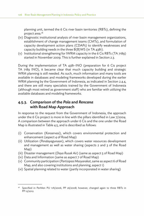
106 River Basin Management Planning in Indonesia: Policy and Practice
planning unit, termed the 6 Cis river basin territories (RBTs), defining the project area.28
(iv) Diagnostic institutional analysis of river basin management organizations, establishment of change management teams (CMTs), and formulation of capacity development action plans (CDAPs) to identify weaknesses and capacity building needs in the three B(B)WS (in TA 4381).
(v) Institutional strengthening for IWRM capacity in the 6 Cis RBTs (TA 7189) started in November 2009. This is further explained in Section 2.3.
During the implementation of TA 4381-INO (preparation for 6 Cis project TA 7189 INO), it became clear that much capacity building and strategic WRM planning is still needed. As such, much information and many tools are available in databases and modeling frameworks developed during the earlier WRM planning by the Government of Indonesia, as indicated in Section 2.4.4, and there are still many specialists trained by the Government of Indonesia (although most retired as government staff) who are familiar with utilizing the available databases and modeling frameworks.
4.5.3. Comparison of the Pola and Rencana with Road Map Approach
In response to the request from the Government of Indonesia, the approach under the 6 Cis project is more in line with the pillars identified in Law 7/2004. A comparison between the approach under 6 Cis and the one under the Road Map is illustrated in Table 4.5, and is described as follows:
(i) Conservation (Konservasi), which covers environmental protection and enhancement (aspect 4 of Road Map)
(ii) Utilization (Pendayagunaan), which covers water resources development and management as well as water sharing (aspects 2 and 3 of the Road Map)
(iii) Disaster management (Daya Rusak Air) (same as aspect 5 of Road Map)(iv) Data and Information (same as aspect 7 of Road Map)(v) Community participation (Partisipasi Masyarakat, same as aspect 6 of Road
Map, and also covering institutions and planning, aspect 1)(vi) Spatial planning related to water (partly incorporated in water sharing)
28 Specified in PerMen PU 11A/2006, PP 26/2008; however, changed again to three RBTs in PP 12/2012.

Basin Planning Required in Indonesia 107Ta
ble
4.5:
Ove
rvie
w o
f Mea
sure
s and
Impa
ct o
n Va
rious
Asp
ects
Mea
sure
Inst
itutio
nsan
d Pl
anni
ngU
tiliz
atio
nW
ater
Shar
ing
Cons
erva
tion
Dam
age
Redu
ctio
nPu
blic
Pa
rtic
ipat
ion
Dat
a an
d In
form
atio
ni.
Cons
erva
tion
a. E
rosio
n Co
ntro
lb.
Run
off
redu
ctio
nc.
Wat
er Q
ualit
y Co
ntro
l
+ + +
+ +
+ + +
+ ++ + +
+ + +
ii. U
tiliza
tion
a. D
eman
d M
anag
emen
tb.
Mor
e st
orag
ec.
Gro
undw
ater
M
anag
emen
td.
In t
erba
sin
trans
fer/c
onto
ur
cana
ls
+ + + +
+ + + +
+ + +
++
+ + + +
+ + + +
iii. W
ater
Saf
ety
a. Z
onin
g Re
gula
tions
and
bu
ildin
g cod
esb.
Ups
tream
/ D
owns
tream
rela
tions
hips
c. R
iver
M
aint
enan
ced.
Con
trolle
d Fl
oodi
nge.
Enh
ance
d Re
tent
ion
f. Fl
ood
Prot
ectio
n
+ + + + + +
+ + + +
+ + +
+ + +
+ + + + + +
+ + + + + +
+ + + + + +So
urce
: Aut
hor.

108 River Basin Management Planning in Indonesia: Policy and Practice
Although the Road Map approach is not officially endorsed in the legislation, it has clear links with the official regulation and has the potential to complement the official regulation to fill some essential gaps. Table 4.5 indicates how the measures under the main components in Law 7/2004 link with the main components of the Road Map approach. Box 4.6 provides an overview of how the Road Map approach can fill some essential gaps in the present regulation.
Box 4.6: Road Map Approach
(i) Participation is better arranged in the Road Map approach, enhancing support by all stakeholders.
(ii) Under the Road Map approach, a Road Map Coordination Management Unit has been established to monitor the progress in planning and follow up in the annual budgets.
(iii) The Road Map approach comprises capacity development through diagnostic institutional analysis of river basin management organizations, establishment of change management team, and capacity development action plans to identify and mitigate weaknesses and capacity-building needs in the Wilayah Sungai (river basin territory).
Source: Author’s assessment.

5 Methodology of Basin Planning in Indonesia
5.1. Introduction
Several methodologies and tools have been developed to support the analyses for the Pola and Rencana. This chapter deals with these methodologies and tools. The presentation follows the different aspects of
water resources as specified in the pillars of Law 7/2004: conservation, utilization, and damage control, supported by data and information management and public participation. Also, adequate attention is given to support integration of the various aspects. An overview is as follows:
5.2. Methodology
5.2.1. Conservation5.2.1.1. Conservation of Land and Soil
The measures concerning conservation of critical catchments can usually be based on the surveys and analyses made by the Center for Catchment Management (BPDAS) under the Ministry of Forestry. They have prepared a technical plan for rehabilitation of forest and land (RTkRHL), which is an inventory of critical areas based on the universal soil loss equation (USLE) criteria (rainfall, slope, type of soil, and land management), and the ratio of minimum and maximum discharges. BPDAS classified the land into:
(i) Very critical • addressed with first priority (stage 1, see below)(ii) Critical • partly stage 1 and partly stage 2(iii) Moderately critical • partly stage 2 and partly stage 3(iv) Potentially critical • stage 3(v) Not critical • no need to be addressed
For each type of area, the BPDAS identifies the area, the measures to be taken to protect the land, and the cost of these measures. The action plan for the Rencana will divide all these measures for more equal distribution of efforts over time in three stages: stage 1 will address the entire “very critical land” and part of “critical land,” stage 2 will address the remainder of the “critical land” and
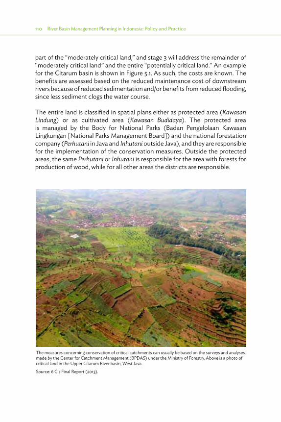
110 River Basin Management Planning in Indonesia: Policy and Practice
part of the “moderately critical land,” and stage 3 will address the remainder of “moderately critical land” and the entire “potentially critical land.” An example for the Citarum basin is shown in Figure 5.1. As such, the costs are known. The benefits are assessed based on the reduced maintenance cost of downstream rivers because of reduced sedimentation and/or benefits from reduced flooding, since less sediment clogs the water course.
The entire land is classified in spatial plans either as protected area (Kawasan Lindung) or as cultivated area (Kawasan Budidaya). The protected area is managed by the Body for National Parks (Badan Pengelolaan Kawasan Lingkungan [National Parks Management Board]) and the national forestation company (Perhutani in Java and Inhutani outside Java), and they are responsible for the implementation of the conservation measures. Outside the protected areas, the same Perhutani or Inhutani is responsible for the area with forests for production of wood, while for all other areas the districts are responsible.
The measures concerning conservation of critical catchments can usually be based on the surveys and analyses made by the Center for Catchment Management (BPDAS) under the Ministry of Forestry. Above is a photo of critical land in the Upper Citarum River basin, West Java.
Source: 6 Cis Final Report (2013).
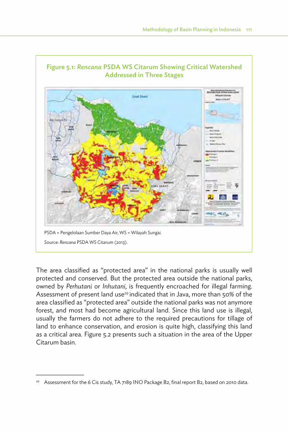
Methodology of Basin Planning in Indonesia 111
The area classified as “protected area” in the national parks is usually well protected and conserved. But the protected area outside the national parks, owned by Perhutani or Inhutani, is frequently encroached for illegal farming. Assessment of present land use29 indicated that in Java, more than 50% of the area classified as “protected area” outside the national parks was not anymore forest, and most had become agricultural land. Since this land use is illegal, usually the farmers do not adhere to the required precautions for tillage of land to enhance conservation, and erosion is quite high, classifying this land as a critical area. Figure 5.2 presents such a situation in the area of the Upper Citarum basin.
29 Assessment for the 6 Cis study, TA 7189 INO Package B2, final report B2, based on 2010 data.
Figure 5.1: Rencana PSDA WS Citarum Showing Critical Watershed Addressed in Three Stages
PSDA = Pengelolaan Sumber Daya Air, WS = Wilayah Sungai.
Source: Rencana PSDA WS Citarum (2013).

112 River Basin Management Planning in Indonesia: Policy and Practice
Most of the area outside the protected area is the responsibility of the districts. Therefore, close cooperation is required between the Ministry of Forestry, the BPDAS, and the districts to assess the best way to implement the proposed measures. Usually, programs for replanting of forests are selected, because budgets and facilities are available (nurseries for plants). But this is not sustainable, since most of the trees will be withering or cut before they are 3 years old, because the community has no interest to take good care of the forests.
A more sustainable way to ensure conservation is to allow farmers to grow trees that are beneficial to them, such as coffee or fruit trees (especially durian). In this scenario, they will protect the plant or tree. There are several good examples of this in the 6 Cis area.
In the area around Cidanau, near Cilegon in Banten province, the local industrial water supply company (PT Krakatau Tirta) has made a contract with farmers to
Figure 5.2: Upper WS Citarum Kawasan Lindung and Less Forest
WS = Wilayah Sungai.
Source: Rencana Pengelolaan Sumber Daya Air WS Citarum (2013).

Methodology of Basin Planning in Indonesia 113
grow and maintain these trees, and is paying them an annual sum for each tree that is still standing. More upstream–downstream relationships are promoted.
Another laudable initiative is made by PT Hijau Lestari, a joint venture of several government agencies (PJT 2, Perhutani) and one private firm, which in 2009 started to assist a group of farmers to plant and cultivate coffee plants and grow trees for fruits and wood for 3 years, until the first coffee plants became productive. In return, PT Hijau Lestari received a share of the profits after these 3 years, and uses it as a revolving fund to assist more farmer groups.
5.2.1.2. Conservation of Water Quantities
Enhancing water retention is another aim of conservation in critical catchments. This is mostly realized through optimal use of depressions and small dams (Embung or similar). Planting of trees controls soil erosion and facilitates retention of rainwater. This, however, also increases consumption of water and evaporation. Therefore, it is unclear to what extent trees contribute to higher dry season water flows.30 Larger interventions for water retention are discussed in Section 5.2.2.
5.2.1.3. Conservation of Water Quality
Water quality in rivers, reservoirs, and canals is regularly monitored. But nothing is done with the data, and even if water quality is seriously deteriorating, no follow-up action is taken. Figure 5.3 presents an example of water quality at various points in the Citarum River (expressed as chemical oxygen demand [COD], maximum value of which, according to World Health Organization standards, is 20 milligrams per liter [mg/l] [red line in Figure 5.3]). It shows the beneficial effect of the reservoirs (acting as giant septic tanks). But otherwise the water quality is deteriorating from upstream to downstream, first when it passes Bandung, and later after the last reservoir. It also shows the deterioration over time.
Assessment of sources of pollution contributing to COD and other water quality indicators such as biological oxygen demand (BOD) in Citarum was done by DHV under the 6 Cis project.31 Pollution due to three sources was identified: domestic and municipal, industry, and agriculture. This was done by estimating (i) the water used by each category of consumer, (ii) the pollution
30 DHV – PusAir 2012: Assessment of impact of changing land use on water availability—PU DGWR.
31 DHV 2012: Water quality assessment in Upper Citarum—PU DGWR.
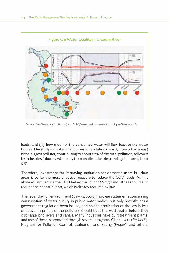
114 River Basin Management Planning in Indonesia: Policy and Practice
loads, and (iii) how much of the consumed water will flow back to the water bodies. The study indicated that domestic sanitation (mostly from urban areas) is the biggest polluter, contributing to about 62% of the total pollution, followed by industries (about 32%, mostly from textile industries) and agriculture (about 6%).
Therefore, investment for improving sanitation for domestic users in urban areas is by far the most effective measure to reduce the COD levels. As this alone will not reduce the COD below the limit of 20 mg/l, industries should also reduce their contribution, which is already required by law.
The recent law on environment (Law 32/2009) has clear statements concerning conservation of water quality in public water bodies, but only recently has a government regulation been issued, and so the application of the law is less effective. In principle, the polluters should treat the wastewater before they discharge it to rivers and canals. Many industries have built treatment plants, and use of these is promoted through several programs: Clean rivers (Prokasih), Program for Pollution Control, Evaluation and Rating (Proper), and others.
Figure 5.3: Water Quality in Citarum River
Source: Yusuf Iskandar (PusAir 2011) and DHV (Water quality assessment in Upper Citarum 2012).

Methodology of Basin Planning in Indonesia 115
However, the Provincial Bureau of Environment - Badan Pengelola Lingkungan Hidup Daerah (BPLHD) has no mandate to sanction industries when they do not abide by the rules. Therefore, they have equipped the communities along the river with mobile phones, inviting them to report clear discharges of waste, so that the BPLHD can assist them with measuring the pollution, which will become evidence in a civil case at court, started by the community against the polluting industry. This measure has already met with considerable success.
The investments in sanitation and pollution control are highly feasible, as shown in the same study. A cost–benefit ratio of 2 applies, and this could be even more if the waste is reused. However, only 50% of these benefits have a bearing on direct financial cost (less chemicals for treatment, increasing land value, etc.), whereas the other 50% manifests as indirect economic benefits, such as improved health. More information on this can be found in Section 5.5 on water quality management.
5.2.2. Water UtilizationAnalysis for water utilization requires (i) an assessment of bottlenecks and (ii) an assessment of possible measures to tackle the existing bottlenecks and prevent creation of new ones. The first assessment is based on a detailed inventory of water balances between water availability and water demand for particular areas (in current practice in Indonesia, while using River Basin Simulation (RIBASIM), these areas are called water districts), usually taken as an area draining toward a certain section of the river, selected between two clear nodes of the river, such as confluence, reservoir outlet, major intake, etc.
Water availability is based on records from stations with sufficiently long and reliable time series. Sometimes, such records on discharges are available, but usually only rainfall data are available, and an educated guess has to be made about the rainfall-runoff relationship. For most areas in the world, sufficiently reliable rainfall–runoff relationships have already been established.
Water demand is estimated based on land use and population. Irrigation demand is related to the irrigated area served from a certain intake, and the cropping pattern in that scheme (or part of scheme). Domestic water demand depends on the urban status of the area and population, as shown in Table 5.1.
Municipal and industrial demand are usually expressed as a percentage of domestic demand, but for specific big industries wherein the water requirements are known, they are taken into consideration.
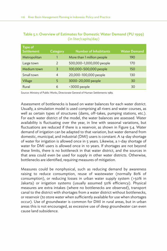
116 River Basin Management Planning in Indonesia: Policy and Practice
Assessment of bottlenecks is based on water balances for each water district. Usually, a simulation model is used comprising all rivers and water courses, as well as certain types of structures (dams, off-takes, pumping stations, etc.). For each water district of the model, the water balances are assessed. Water availability is fluctuating over the year, in line with seasonal variations, but fluctuations are reduced if there is a reservoir, as shown in Figure 5.4. Water demand of irrigation can be adapted to that variation, but water demand from domestic, municipal, and industrial (DMI) users is constant. A 14-day shortage of water for irrigation is allowed once in 5 years. Likewise, a 1-day shortage of water for DMI users is allowed once in 10 years. If shortages are not beyond these limits, there is no bottleneck in that water district, and the sources in that area could even be used for supply in other water districts. Otherwise, bottlenecks are identified, requiring measures of mitigation.
Measures could be nonphysical, such as reducing demand by awareness raising to reduce consumption, reuse of wastewater (normally 80% of consumption), or reducing losses in urban water supply system (>50% in Jakarta) or irrigation systems (usually assumed 50% efficiency). Physical measures are extra intakes (where no bottlenecks are observed), transport canal to the district with shortages from a water district without bottlenecks, or reservoir (to store water when sufficiently available for use when shortages occur). Use of groundwater is common for DMI in rural areas, but in urban areas this is not encouraged, as excessive use of deep groundwater can even cause land subsidence.
Table 5.1: Overview of Estimates for Domestic Water Demand (PU 1999) (in liter/capita/day)
Type of Settlement Category Number of Inhabitants Water DemandMetropolitan 1 More than 1 million people 190Large town 2 500,000–1,000,000 people 170Medium town 3 100,000–500,000 people 150Small town 4 20,000–100,000 people 130Village 5 3000–20,000 people 30Rural 6 <3000 people 30
Source: Ministry of Public Works, Directorate General of Human Settlements 1989.

Methodology of Basin Planning in Indonesia 117
5.2.3. Disaster Management The analyses for this aspect will first focus on inventory of events and damage. After that, focus will be on areas with the most serious damage, comprising assessment of causes of the events causing these most serious damage, and possibilities to reduce the damage or frequency of occurrence. As such, the important initial factors are as follows:
(i) Occurrence of floods, droughts, and landslides (ii) Related damage
Then, for areas with most serious damage, the important factors are as follows:
(i) Causes of the events(ii) Nonphysical measures
a. Raising awareness to prevent development in these areas (licenses for new development) or taking adequate measures to tackle disasters and reduce damage such as1. Flood and drought warning and adjusted cropping plan2. Controlled flooding and water sharing
Figure 5.4: Water Balance in the Citarum Basin
0
100
200
300
400
500
600
700
800
JAN
-1
FEB-
1
MA
R-1
APR
-1
MA
Y-1
JUN
-1
JUL-
1
AU
G-1
SEP-
1
OCT
-1
NO
V-1
DEC
-1
(m3 /d
t)
Water Balance (Demand vs. Supply) in Citarum (2010)
Total natural water availability Irrigation, 2010
DMI, 2010 Total water availibility (reservoir)
Fisheries, 2010 Total water demand 2010
DMI = domestic, municipal, and industrial; PSDA = Pengelolaan Sumber Daya Air; WS = Wilayah Sungai.
Source: Rencana PSDA WS Citarum (2013).
118 River Basin Management Planning in Indonesia: Policy and Practice
(iii) Physical measures (a) Adequate maintenance of existing infrastructures (b) New infrastructure, if feasible
The hydrologists will assess current practices at the hydrological databases and provide recommendations. This will not only concern hydrological data but also hydrometry as practiced by Balai Wilayah Sungai (Greater Basin Territory Center, Ministry of Public Works level) (BWS) or Provincial or District Water Resources Service (PU Pengairan) (Dinas PSDA), as well as hydrometeorology and hydroclimatology as addressed in cooperation with the Indonesian Institute for Meteorology, Climatology, and Geophysics (BMKG).
5.2.4. Data and Information The Directorate General for Water Resources at Ministry of Public Works (DGWR) has established a strategy to improve data and information management concerning hydrology and hydrometrics, hydrogeology, and hydroclimatology (SIH3). For planning, the hydrologists will assess current practices at the hydrological databases and provide recommendations.
This will not only concern hydrological data but also hydrometrics as practiced by Balai (Besar) Wilayah Sungai (Greater Basin Territory Center, Ministry of Public Works level) [B(B)WS] or Dinas PSDA, as well as hydrogeology (groundwater) as addressed in cooperation with the Ministry and Dinases for Energy and Natural Resources (ESDM), hydrometeorology and hydroclimatology as addressed in cooperation with BMKG (Badan Meteorologi, Klimatologi dan Geofisika [Indonesian Institute for Meteorology, Climatology, and Geophysics]).
(i) Check availability (ii) Check data collection (iii) Check data processing (validation/rainfall data consistency/river flow, etc.)(iv) Check data management (sustainability)(v) Check reporting (access to data)(vi) Advise for improvement
5.2.5. Community Participation and Institutional AspectsTwo main aims of the activities addressing this aspect are as follows:
1) Make effective use of the in-depth knowledge of the stakeholders to present a more complete picture of the present situation, the prevailing issues, and aspired priorities for development.
2) Develop an effective platform for cooperation between the various stakeholders based on mutual trust and a shared vision of the present

Methodology of Basin Planning in Indonesia 119
situation, considering the causes of the different bottlenecks and the preferred solutions for improvement.
This can be achieved when the institutional specialist assesses the institutional situation, especially the organizations involved in WRM, and the stakeholder platforms, such as the TKPSDA, including an assessment of issues perceived and development aspired. Based on this, the institutional specialists will assist in establishing transparent information sharing through an intensive approach of the stakeholders in focus group discussions (FGDs), workshops, and public consultation meetings (PCMs).
(i) Inventory of related sector: irrigation, drinking water supply companies (PAM), industry, forestry, etc., in FGD per kabupaten.a. What institutions exist?b. What do they see as prevailing issues?c. What proposals do they have to solve these issues?d. Use first workshop for transparent information sharing and raising
commitment: assignment of permanent representative by all involved institutions.
(ii) Support the TKPSDA in this process.(iii) Make sure all topics have been discussed in FGD with specific groups
of stakeholders, before organizing the general PCM, to increase its effectiveness, to address the point that the Pola and Rencana are of common interest, and not “too much owned by PU,” and to stimulate more ownership with other sectors.
(iv) Assess potential for cost recovery.
The knowledge and experience of the stakeholders can assist in presenting a more complete picture of the present situation, the prevailing issues, and aspired priorities in development.

120 River Basin Management Planning in Indonesia: Policy and Practice
5.3. Integration
5.3.1. Island-Wide Approach The basin plans offer a comprehensive view on what is needed within one basin and what can be done. However, a comparison between the various basins is necessary to assess the urgency of the problems, priorities for intervention, and possibilities of one basin helping the neighboring basins. An island approach to planning offers the possibility for such comparisons. For Java, the Java Water Resources Strategic Study (JWRSS), which was prepared in 2010–2012, is a useful example for such island-wide approach. For instance, water shortages and flood problems are identified in all basins. But in which basin are the problems more serious or more easily solved? Comparison based on unified criteria is one possibility. Table 5.2 shows the indicators used in JWRSS for different themes. Figure 5.5 and Table 5.3 show how this worked out for “too much water.” The most seriously affected analytical units are colored in red, the medium ones in yellow, and the minor ones in green.
Table 5.2: Themes and Indicators
Theme Indicators (per Analytical Unit for 2010 and 2030)
Floods/too much water
Number of people in flood-prone areasPercentage of people in flood-prone areasLand subsidence
Drought/utilization/too little water
Water balance assessment (surplus and shortages)Rice intensification potential
Water quality/too dirty water
Environmental pressure, biological oxygen demand loads Upstream/downstream issues
Erosion and sedimentation/too much sediment
Percentage of highly erodible areas in JAU—good managementPercentage of highly erodible areas in JAU—bad managementRelation to reservoirsRelation to floods
Socioeconomic value
Welfare perspective Number of people in JAUShare of GRP in Java produced in JAU
Equity perspectiveGRP per capita in JAUpercentage of people employed in the agriculture sector by JAUpercentage of population with an income under the poverty line
GRP = gross regional product, JAU = Java Water Resources Strategic Study Analytical Unit.
Source: Deltares et al., JWRSS – BAPPENAS – PU (2012).

Methodology of Basin Planning in Indonesia 121
Figure 5.5: Analytical Units Showing Hot Spots “Too Much” (Units Most Affected by Floods)
Source: Deltares et al., JWRSS – BAPPENAS – PU (2012).
Another benefit is that it allows for identification and assessment of possibilities for mutual assistance between the various WS. Figure 5.6 shows the results for water shortages and utilization in Java from JWRSS, and, where possible, interbasin transfers have been identified and assessed.
The island-wide approach exemplified by the JWRSS project could potentially be used to provide boundary conditions for subsequent Polas and Rencanas for the various basins in Java, in particular related to objectives for irrigated agriculture and options for interbasin transfers, but also related to flooding and water quality issues. Another way is to assess the different feasibility studies and compare the internal rate of return. This, however, leads to a series of problems. Different studies will have different base years, different time frames, different assumptions regarding investment costs and benefits, different discounting rates, etc. Compiling conclusions for the various regions in Indonesia on the basis of feasibility studies for individual basins will be very difficult, if not impossible. An island-wide analysis such as JWRSS ensures a uniform approach, and useful conclusions regarding where to focus with various types of measures.
In case an island-wide approach would be realized for all islands and regions in Indonesia, the outcome could be very useful not only in helping to set national priorities related to questions where to invest in what types of measures but also in determining whether the future national rice production can be expected to be more or less in line with aspirations of the nation for self-sufficiency.
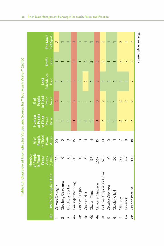
122 River Basin Management Planning in Indonesia: Policy and Practice
Tabl
e 5.
3: O
verv
iew
of t
he In
dica
tor V
alue
s and
Sco
res f
or “
Too
Muc
h W
ater
” (20
10)
IDJW
RMS
Ana
lytic
al U
nit
Num
ber
of P
eopl
e in
Flo
od-
Pron
e A
reas
(*
1,000
)
% o
f Pe
ople
in
Flo
od-
Pron
e A
reas
Num
ber
of P
eopl
e in
Flo
od-
Pron
e A
reas
% o
f Pe
ople
in
Flo
od-
Pron
e A
reas
Land
Su
bsid
ence
Iss
ueTr
affic
Issu
eTo
o M
uch
Hot
Spo
ts1
Cilim
an C
ibun
gur
188
201
31
12
2Ci
baliu
ng C
isaw
arna
00
11
11
13
Kepu
laua
n Se
ribu
00
11
11
14a
Ceku
ngan
Ban
dung
931
153
33
33
4bCi
taru
m T
enga
h0
01
11
11
4cCi
taru
m H
ilir21
11
12
21
4dCi
taru
m T
imur
137
41
11
21
4eCi
liwun
g-Ci
sada
ne3,
567
163
33
33
4fCi
dana
u-Ci
ujun
g-Ci
duria
n57
510
22
12
25
Cisa
dea
Ciba
reno
00
11
11
16
Ciw
ulan
Cila
ki20
11
11
11
7Ci
tand
uy29
37
22
12
28a
Cim
anuk
327
82
21
22
8bCi
rebo
n Pa
ntur
a50
014
22
22
2
cont
inue
d on
nex
t pag
e

Methodology of Basin Planning in Indonesia 123
IDJW
RMS
Ana
lytic
al U
nit
Num
ber
of P
eopl
e in
Flo
od-
Pron
e A
reas
(*
1,000
)
% o
f Pe
ople
in
Flo
od-
Pron
e A
reas
Num
ber
of P
eopl
e in
Flo
od-
Pron
e A
reas
% o
f Pe
ople
in
Flo
od-
Pron
e A
reas
Land
Su
bsid
ence
Iss
ueTr
affic
Issu
eTo
o M
uch
Hot
Spo
ts8c
Cisa
ngga
rung
785
12
12
19
Pem
ali C
omal
126
21
11
21
10a
Jrag
ung T
unta
ng76
523
33
33
310
bSe
rang
Lus
i Juw
ana
583
122
21
22
11Bo
dri K
uto
232
11
12
112
Wiso
Gel
is0
01
11
11
13Ke
pula
uan
Karim
unja
wa
00
11
11
114
aSe
rayu
291
11
12
114
bLu
k Ulo
Bog
owon
to47
217
23
12
215
aPr
ogo
Sera
ng10
64
11
12
115
bO
pak O
yo15
48
12
11
115
cG
unun
g Sew
u18
51
21
11
16a
Grin
dulu
Lor
og49
91
21
11
16b
Mad
iun
433
152
31
22
16c
Beng
awan
Sol
o H
ulu
157
31
11
11
Tabl
e 5.3
con
tinue
d
cont
inue
d on
nex
t pag
e
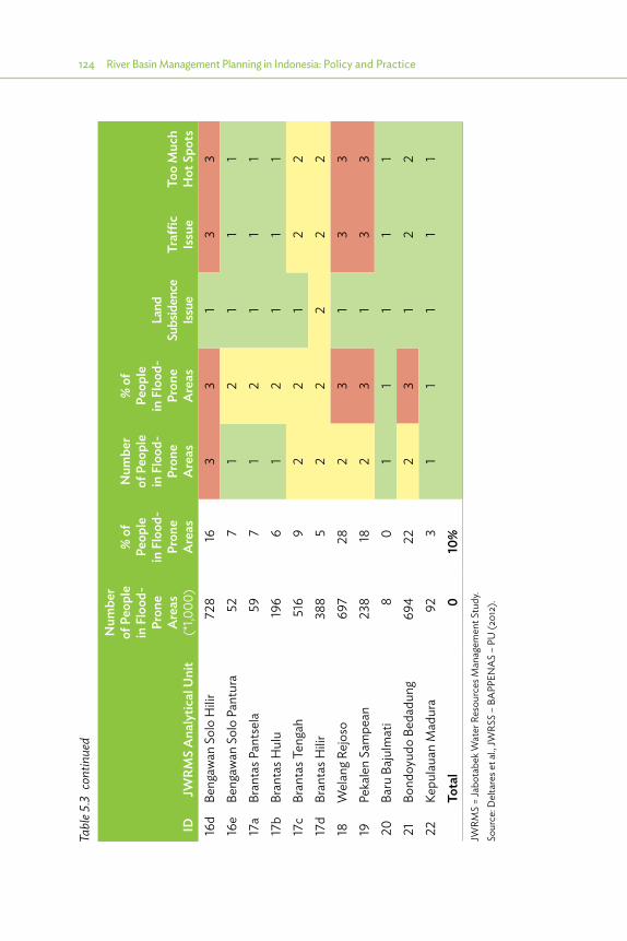
124 River Basin Management Planning in Indonesia: Policy and Practice
IDJW
RMS
Ana
lytic
al U
nit
Num
ber
of P
eopl
e in
Flo
od-
Pron
e A
reas
(*
1,000
)
% o
f Pe
ople
in
Flo
od-
Pron
e A
reas
Num
ber
of P
eopl
e in
Flo
od-
Pron
e A
reas
% o
f Pe
ople
in
Flo
od-
Pron
e A
reas
Land
Su
bsid
ence
Iss
ueTr
affic
Issu
eTo
o M
uch
Hot
Spo
ts16
dBe
ngaw
an S
olo
Hilir
728
163
31
33
16e
Beng
awan
Sol
o Pa
ntur
a52
71
21
11
17a
Bran
tas P
ants
ela
597
12
11
117
bBr
anta
s Hul
u19
66
12
11
117
cBr
anta
s Ten
gah
516
92
21
22
17d
Bran
tas H
ilir38
85
22
22
218
Wel
ang R
ejos
o69
728
23
13
319
Peka
len
Sam
pean
238
182
31
33
20Ba
ru B
ajul
mat
i8
01
11
11
21Bo
ndoy
udo
Beda
dung
694
222
31
22
22Ke
pula
uan
Mad
ura
923
11
11
1
Tota
l0
10%
JWRM
S =
Jabo
tabe
k Wat
er R
esou
rces
Man
agem
ent S
tudy
.So
urce
: Del
tare
s et a
l., JW
RSS
– BA
PPEN
AS
– PU
(201
2).
Tabl
e 5.3
con
tinue
d

Methodology of Basin Planning in Indonesia 125
IDJW
RMS
Ana
lytic
al U
nit
Num
ber
of P
eopl
e in
Flo
od-
Pron
e A
reas
(*
1,000
)
% o
f Pe
ople
in
Flo
od-
Pron
e A
reas
Num
ber
of P
eopl
e in
Flo
od-
Pron
e A
reas
% o
f Pe
ople
in
Flo
od-
Pron
e A
reas
Land
Su
bsid
ence
Iss
ueTr
affic
Issu
eTo
o M
uch
Hot
Spo
ts16
dBe
ngaw
an S
olo
Hilir
728
163
31
33
16e
Beng
awan
Sol
o Pa
ntur
a52
71
21
11
17a
Bran
tas P
ants
ela
597
12
11
117
bBr
anta
s Hul
u19
66
12
11
117
cBr
anta
s Ten
gah
516
92
21
22
17d
Bran
tas H
ilir38
85
22
22
218
Wel
ang R
ejos
o69
728
23
13
319
Peka
len
Sam
pean
238
182
31
33
20Ba
ru B
ajul
mat
i8
01
11
11
21Bo
ndoy
udo
Beda
dung
694
222
31
22
22Ke
pula
uan
Mad
ura
923
11
11
1
Tota
l0
10%
JWRM
S =
Jabo
tabe
k Wat
er R
esou
rces
Man
agem
ent S
tudy
.So
urce
: Del
tare
s et a
l., JW
RSS
– BA
PPEN
AS
– PU
(201
2).
Figure 5.6: Overview of Hot Spots for Water Utilization and Potential Inter-WS Transfers
WS = Wilayah Sungai.
Source: Deltares et al., JWRSS – BAPPENAS – PU (2012).
5.3.2. Water Resources Management and Spatial Planning for Food Security32
Indonesia formulated Law 41/2009 and Government Regulation PP 1/2011 to provide a legal framework to limit land conversion for present and potential highly productive land through adequate spatial planning. The district spatial plans (RTRW) have been formulated from 2008 to 2012. In the final stages of that process, sustainable food production areas were identified to provide protection for highly productive agricultural land according to Law 41/2009 and PP 1/2011. However, only about 50% of the existing agricultural land is currently protected in the district spatial plans.
Further protection of farmland in spatial plans is therefore urgently needed. Based on an inventory of all legalized district spatial plans, agricultural statistics from the Central Statistics Agency (BPS), the recently released map of rice fields
32 Based on DHV et al. Water for Food Security in Indonesia 2013, for Ministry of Public Works (MPW) and the Kingdom of the Netherlands.
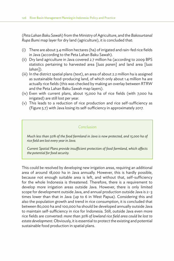
126 River Basin Management Planning in Indonesia: Policy and Practice
(Peta Lahan Baku Sawah) from the Ministry of Agriculture, and the Bakosurtanal Rupa Bumi map layer for dry land (agriculture), it is concluded that:
(i) There are about 3.4 million hectares (ha) of irrigated and rain-fed rice fields in Java (according to the Peta Lahan Baku Sawah).
(ii) Dry land agriculture in Java covered 2.7 million ha (according to 2009 BPS statistics pertaining to harvested area [luas panen] and land area [luas lahan]).
(iii) In the district spatial plans (text), an area of about 2.2 million ha is assigned as sustainable food-producing land, of which only about 1.4 million ha are actually rice fields (this was checked by making an overlay between RTRW and the Peta Lahan Baku Sawah map layers).
(iv) Even with current plans, about 15,000 ha of rice fields (with 7,000 ha irrigated) are still lost per year.
(v) This leads to a reduction of rice production and rice self-sufficiency as (Figure 5.7) with Java losing its self-sufficiency in approximately 2017.
Conclusion
Much less than 50% of the food farmland in Java is now protected, and 15,000 ha of rice field are lost every year in Java.
Current Spatial Plans provide insufficient protection of food farmland, which affects the potential for food security.
This could be resolved by developing new irrigation areas, requiring an additional area of around 18,000 ha in Java annually. However, this is hardly possible, because not enough suitable area is left, and without that, self-sufficiency for the whole Indonesia is threatened. Therefore, there is a requirement to develop more irrigation areas outside Java. However, there is only limited scope for development outside Java, and annual production outside Java is 2–3 times lower than that in Java (up to 6 in West Papua). Considering this and also the population growth and trend in rice consumption, it is concluded that between 80,000 ha and 100,000 ha should be developed annually outside Java to maintain self-sufficiency in rice for Indonesia. Still, outside Java even more rice fields are converted: more than 30% of lowland rice field area could be lost to estate development. Obviously, it is essential to protect the existing and potential sustainable food production in spatial plans.

Methodology of Basin Planning in Indonesia 127
Figure 5.7: Rice Production and Consumption Trend in Java
120
100
80
60
40
20
02010
40
35
30
25
20
15
10
5
02020
Rice production (million ton/year) Rice production (million ton/year)
Rice self-su�ciency
Prod
uctio
n co
nsum
ptio
n (t
on/y
ear)
Perc
ent
20402030 2050
From 2017 not self-su�cient
Source: DHV et al. 2014. Water for Food Security in Indonesia, for Ministry of Public Works (MPW) and the Kingdom of the Netherlands.
The main role of water resources planning in supporting food security is to provide adequate water for irrigation. Irrigation poses the largest water demand, and the water resources sector should maintain current water infrastructure and safeguard the water availability as well as develop new renewable water resources (such as reservoirs) to support food production. The nonavailability of water is limiting food production especially in East Java.
5.3.3. Water Resources Management and Spatial Planning for Conservation, Water Utilization, and Flood Management33*
5.3.3.1. Important Link between Water Resources and Spatial Planning
The link between water resources (B.1) and spatial planning (B.2) has already been described in Section 2.4.3 and Figure 5.8.
33 6 Cis study, TA 7189 INO Package B2, final report B2.

128 River Basin Management Planning in Indonesia: Policy and Practice
•� The water resources plans (B1: Pola or Rencana) will indicate spatial consequences such as land for reservoirs and canals or land affected by floods (flood zones). The Pola and Rencana will also have spatial impacts on the required infiltration zones or on protection against erosion or pollution, and these zones should be identified in the spatial plan for special consideration when issuing building permits.
•� The spatial plan (B2) identifies land use and related water demand for irrigation; domestic, municipal, and industrial needs, etc. Spatial changes, with higher populations in more urban areas, will trigger higher demands and (with harder surface) more rapid runoff, and this will be input into water resources planning (B1).
•� In principle, the spatial plans already exist and are used for estimating demand in formulation of the Pola and Rencana. After completion of the Pola or Rencana, there will be reviews of the spatial plans, and then the requirements and impacts from the water resources should be checked (water audit), and conflicts, if any, should be mitigated through zoning: identifying the land that requires special considerations when issuing permits.
The 6 Cis study identified some essential points for interaction and provided tools for quantification of the interrelationships, as described below.
Figure 5.8: Relations between Water Resources Planning and Spatial Planning
B1
B2
Water resourcesplanning (riverbasin scope)
Quantificationof Strategic
Water Zoning
Spatial planning(national,
island scope)
Projections forpopulation
and land use
Input from spatialplanning to WRM plan
urban leads to Q!
Delineation andimpacts are input tothe spatial planning
process!
Conflict resolution; valuationof alternative land use
WRM = water resources management.
Source: 6 Cis Inception Report (2010).
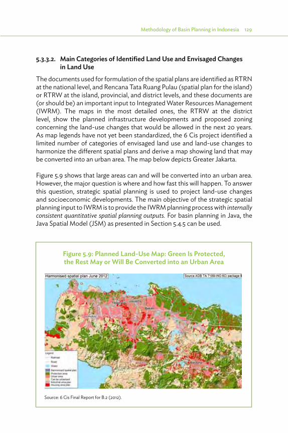
Methodology of Basin Planning in Indonesia 129
5.3.3.2. Main Categories of Identified Land Use and Envisaged Changes in Land Use
The documents used for formulation of the spatial plans are identified as RTRN at the national level, and Rencana Tata Ruang Pulau (spatial plan for the island) or RTRW at the island, provincial, and district levels, and these documents are (or should be) an important input to Integrated Water Resources Management (IWRM). The maps in the most detailed ones, the RTRW at the district level, show the planned infrastructure developments and proposed zoning concerning the land-use changes that would be allowed in the next 20 years. As map legends have not yet been standardized, the 6 Cis project identified a limited number of categories of envisaged land use and land-use changes to harmonize the different spatial plans and derive a map showing land that may be converted into an urban area. The map below depicts Greater Jakarta.
Figure 5.9 shows that large areas can and will be converted into an urban area. However, the major question is where and how fast this will happen. To answer this question, strategic spatial planning is used to project land-use changes and socioeconomic developments. The main objective of the strategic spatial planning input to IWRM is to provide the IWRM planning process with internally consistent quantitative spatial planning outputs. For basin planning in Java, the Java Spatial Model (JSM) as presented in Section 5.4.5 can be used.
Figure 5.9: Planned Land-Use Map: Green Is Protected, the Rest May or Will Be Converted into an Urban Area
Source: 6 Cis Final Report for B.2 (2012).
130 River Basin Management Planning in Indonesia: Policy and Practice
5.3.3.3. Identification and Quantification of the Interrelationships
As such, land use and water management have strong interrelationships, which implies that the documents used for the formulation of long-term management plans, such as spatial plans (RTRN and RTRW) and WRM plans (Pola and Rencana), have to be integrated. However, considerable effort is required to implement these objectives. Especially, information is needed on the interactions, in particular a quantification of the interrelationships, to quantify requirements and impacts and to direct adjustments and adaptations to proposed developments in both water resources and spatial planning to optimize overall development.
In the B2 component of 6 Cis, this quantification considers the following parts (see Figure 5.10):
(i) projection of the pattern of settlement and economic activity to establish demands (present and future) as input to a proactive planning of development (triggered by items 1a, 1b, and 1c);
(ii) indication of impacts associated with those spatial projections (items 2a and 2b), based on modeling and postprocessing of impacts by JSM as explained in Section 5.4.5;
(iii) water resources planning itself (item 3); and(iv) assessment of a set of water zoning requirements addressing the different
aspects of water resources (urban runoff, runoff from upstream catchment, erosion, etc.), which can be influenced by spatial management (item 4).
As such, a set of water sector issues, which require spatial management, have been identified; this takes the form of a water sector zoning which provides the following:
Analysis from item 3 to item 4: constraints on spatial settlement, comprising (a) prohibited development in certain areas (such as space requirements for infrastructure, areas vulnerable for erosion, etc.) or (b) special care for development (such as ΔQ=0 policy in catchments contributing to floods or provision of flood proofing in flood-prone areas); these are usually referred to as “water zoning” requirements.
Analysis from item 4 to item 1: remedial measures in the form of regulations that aim to avoid or compensate adverse effects of settlement (remedial actions or conditional development).
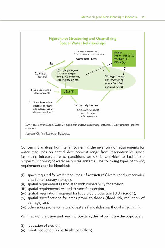
Methodology of Basin Planning in Indonesia 131
Concerning analysis from item 3 to item 4: the inventory of requirements for water resources on spatial development range from reservation of space for future infrastructure to conditions on spatial activities to facilitate a proper functioning of water resources systems. The following types of zoning requirements can be identified:
(i) space required for water resources infrastructure (rivers, canals, reservoirs, area for temporary storage),
(ii) spatial requirements associated with vulnerability for erosion,(iii) spatial requirements related to runoff protection,(iv) spatial reservations required for food crop production (UU 41/2009),(v) spatial specifications for areas prone to floods (flood risk, reduction of
damage), and(vi) other areas prone to natural disasters (landslides, earthquake, tsunami).
With regard to erosion and runoff protection, the following are the objectives:
(i) reduction of erosion, (ii) runoff reduction (in particular peak flow),
Figure 5.10: Structuring and Quantifying Space–Water Relationships
Resource assessment, coordination,
conflict resolution
Water resources
Spatial planningPlans from othersectors: forestry, agriculture, urbandevelopment, etc.
JSM (1)Socioeconomicdevelopments
Resource assessment,interventions and measures
E�ects/impacts fromland-use changes:runo�, Q, emissions,erosion, flooding, etc.
Strategic zoning: conservation ofwater functions(various types)
Water demands
2a
2b
1c
1a1b
3
4
Models:Erosion (USLE) (2)Peak flow (3)SOBEK (4)
JSM = Java Spatial Model, SOBEK = hydrologic and hydraulic model software, USLE = universal soil loss equation.
Source: 6 Cis Final Report for B.2 (2012).
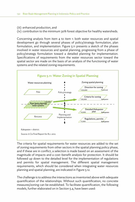
132 River Basin Management Planning in Indonesia: Policy and Practice
(iii) enhanced production, and(iv) contribution to the minimum 30% forest objective for healthy watersheds.
Concerning analysis from item 4 to item 1: both water resources and spatial development go through several phases of policy/strategy formulation, plan formulation, and implementation. Figure 5.11 presents a sketch of the phases involved in water resources and spatial planning, progressing from a phase of policy/strategy formulation toward a detailed planning for implementation. Specifications of requirements from the water resources sector toward the spatial sector are made on the basis of an analysis of the functioning of water systems and the related zoning requirements.
The criteria for spatial requirements for water resources are added to the set of zoning requirements from other sectors in the spatial planning policy phase, and if these are in conflict, a selection is made based on an assessment of the magnitude of impacts and a cost–benefit analysis for protection. It should be followed up down to the detailed level for the implementation of regulations and permits for spatial management. The different spatial management requirements, which should be considered when integrating water resources planning and spatial planning, are indicated in Figure 5.12.
The challenge is to address the interactions as inventoried above with adequate quantification of the relationships. Without such quantification, no concrete measures/zoning can be established. To facilitate quantification, the following models, further elaborated on in Section 5.4, have been used:
Figure 5.11: Water Zoning in Spatial Planning
Pola
Rencana
River basin planningwater systems
Water resources planning
1:25,000
Direction for zoning1:125,000
Criteria for zoning1:50,000
Detailed Kabupatenplan 1:5,000
Regulations, permits1:1,000
Provincial
Kabupaten
Kabupaten
Kabupaten
Planning andImplementation
Zoning spatial planning
Policy/strategy
Kabupaten = district.
Source: 6 Cis Final Report for B.2. 2012.

Methodology of Basin Planning in Indonesia 133
(i) Java Spatial Model. Projection of settlement and employment as a basis for proactive planning (e.g., 2010–2030).
(ii) Soil conservation (erosion) model. Identify sensitive areas and identify measures to deal with sensitive areas; sensitivity of the soil is the key parameter for taking catchment protection measures (zoning).
(iii) Peak flow model. Identify the areas in the catchment which contribute most to the flood peak; zoning to protect from flash floods is most effective in those areas.
(iv) Hydrologic and hydraulic model (SOBEK). Determine the reaction of the urban area (extent of flooding, flow velocities, etc.) to design a rainfall event; used to determine the combination of retention and discharge capacity to reduce flooding to the desirable level.
5.3.4. Integrated Flood Management and Spatial Planning There are special requirements of integration for flood management as it requires a balanced combination of controls on spatial development and structural interventions, and also requires a geographical differentiation of processes and impacts (internal and external drainage). Such an integrated composition is elaborated on in the following section.
Figure 5.12: Implementation of Spatial Management through the Spatial Plan
Specification of protection and rehab zones in national and provincial spatial plans
(Assessment)
Kabupaten spatial plan
Check consistency and potential conflicts with other sectors
First step in legalization of desired spatial management for water management aspect
Second step in legalization, followed by execution of policy
Translation of directives in provincial plan into local plan, taking into account local objectives
Formulation of policy to implement protection
Permits and regulationCooperation agreements (Memorandums of Understanding); for example: agriculture + forestry + private partner+ monitoring B(B)WS, etc.)
B(B)WS = Balai (Besar) Wilayah Sungai (Greater Basin Territory Center, Ministry of Public Works level), Kabupaten = district.
Source: 6 Cis Final Report for B.2 (2012).

134 River Basin Management Planning in Indonesia: Policy and Practice
Optimal flood management requires a comprehensive approach in which structural and nonstructural measures are combined and balanced to provide a maximum protection against minimal costs. Flood defenses cannot provide absolute protection against all possible flooding, but they can reduce the risk of flooding. Building defenses of very high standards may be very expensive, may be highly intrusive in the human and natural environment, and may actually increase risks elsewhere or have disastrous results if any part of the system fails.
Control of land use through zoning plays an important role both to prevent or control excess rainfall and to reduce impact from flooding. Such control can be considered part of the measures to control floods in addition to the classical infrastructural works to improve drainage capacity of channels and the defenses put up to protect surrounding areas.
Figure 5.13 summarizes the different controls on flooding for a typical river basin, differentiating the upstream and downstream parts of the basin; the upstream part has relatively high slopes and the downstream part features extensive urban development with problems of drainage.
Figure 5.13: Overview of Zoning for Flood Management
Meteorologicalcondition
Upper catchment(infiltration,
retention, erosion)
Zoning upstream catchment:− Reforestation, bare soil protection− Special zone for control of peak runo�
Floods fromupstream
Infrastructure:drainage capacity,
defenses
Urban drainage
- Urban retention
Emergency services,awareness
Macro urban development(e.g., network city with
green zones)
∆Q=0 policy Floodplain(s)
- Discharge capacity
Floodplainzoning
Meteorologicalcondition
(Remaining)Damage
Source: P. Grashoff and R. Verhaeghe, personal communication.

Methodology of Basin Planning in Indonesia 135
A differentiation is then made between external and internal flood management. External flood management concerns the safe transfer of floodwater (flood wave) from upstream through a downstream area. Management comprises creation of sufficient flow capacity and measures to minimize damage (floodplain zoning, flood warning systems). Internal drainage concerns the control of excess rainfall in a particular area to minimize damage with a combination of retention and drainage capacity.
In summary, zoning plays an important role in the prevention of flooding and/or reduction of damage. The following types of zoning are identified (as already sketched in Figure 5.11):
(i) Control of land use in the upstream catchment to maximize retention and prevent fast runoff. Reforestation and bare soil protection, considered for erosion, make significant contributions to the control of runoff. Of particular interest is to further the control of land use in that part of the catchment which contributes most to the flood peak.
(ii) Control of land use in urban areas and catchment is directly linked to the urban area and/or potential future urban area (urban building codes, measures to improve retention and infiltration).
(iii) Floodplain zoning: based on flood risk mapping (combinations of flooding depth and duration and return period) and impact assessment, regulations are formulated to minimize impact of flooding, appropriate for different zones of risk on the floodplain.
(iv) Macro urban development: the composition of the urban area, for example, considering a more decentralized (network) concept for the city, spreading the excess rainfall load and allowing for more opportunities for retention, may have a strong effect on the performance of the urban drainage system.
5.3.5. Utilization and Damage Control from Land Subsidence A specific aspect of damage control is the control of land subsidence. Locations in North Jakarta (sinking more than 10 centimeters per year) and North Semarang are seriously affected by land subsidence, with part of the land already regularly flooded by the sea. Also, Bandung is affected by land subsidence reaching 7 centimeters per year at certain points (Dayeuhkolot), and flooding in the depression areas was thus experienced.
The major cause of this land subsidence is almost surely excessive abstraction of groundwater. Therefore, this excessive use of groundwater has to be limited, which is possible only by providing water from alternative sources, in this case
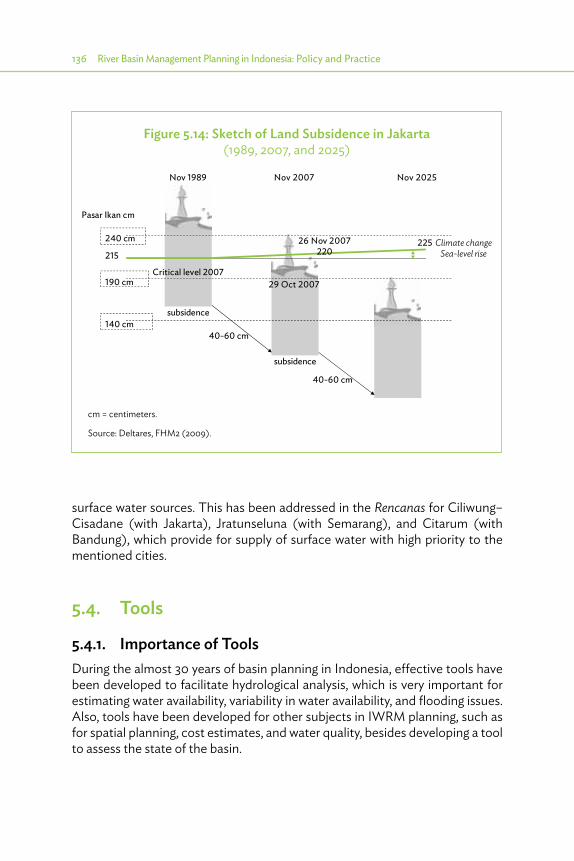
136 River Basin Management Planning in Indonesia: Policy and Practice
surface water sources. This has been addressed in the Rencanas for Ciliwung–Cisadane (with Jakarta), Jratunseluna (with Semarang), and Citarum (with Bandung), which provide for supply of surface water with high priority to the mentioned cities.
5.4. Tools
5.4.1. Importance of Tools During the almost 30 years of basin planning in Indonesia, effective tools have been developed to facilitate hydrological analysis, which is very important for estimating water availability, variability in water availability, and flooding issues. Also, tools have been developed for other subjects in IWRM planning, such as for spatial planning, cost estimates, and water quality, besides developing a tool to assess the state of the basin.
Figure 5.14: Sketch of Land Subsidence in Jakarta (1989, 2007, and 2025)
Climate changeSea-level rise
240 cm
Pasar Ikan cm
Nov 1989 Nov 2007 Nov 2025
190 cm 29 Oct 2007
140 cm
215225
subsidence
40-60 cm
40-60 cm
subsidence
Critical level 2007
26 Nov 2007220
cm = centimeters.
Source: Deltares, FHM2 (2009).

Methodology of Basin Planning in Indonesia 137
However, effective hydrological tools are limited by the existing poor state of the collection of climatological data, and this threatens adequate water resources planning. An example to illustrate this is taken from the 6 Cis project. In that project, an extensive data collection and analysis was carried out for Western Java. This analysis led to the quite unfortunate conclusion that for the period 1980–2009 no reliable database could be established and that only the data for the period 1951–1979 could be used.
Tools have also been developed to facilitate an in-depth analysis of flooding. This relates to hydrodynamic models that are used to route a flood wave through a river (and reservoir) system and also to determine which areas are inundated, to what depth, and for how long. These results can be used to detail potential measures such as the height of dikes, the capacity of pumping stations, etc.
For water allocation analysis, river basin simulation models have been developed and applied for many basins in Indonesia. These models simulate, for ideally many years, the performance of the water resources system, taking into account water demands by various sectors (DMI supply, irrigated agriculture, hydropower generation, fishponds, flushing, etc.) and the availability of water, expressed in time series of river flow and rainfall. These models also take into account the capacity of infrastructure (canals, pipelines, pumping stations) and operation rules for infrastructure (reservoir operation rules). These models are typically used to analyze a situation with and without possible measures (such as weirs, reservoirs, canals, change in cropping pattern, etc.), leading to conclusions on how well a potential measure would perform.
5.4.2. Hydrological Databases The hydrological databases suitable for use in basin management should be comprehensive and be able to handle hydrometeorological data. As such, it should have a comprehensive set of data, and processing tools as follows:
(i) Types of data:(a) space-oriented data: catchment characteristics, station particulars
(including history), geohydrological profiles;(b) time-oriented data: series with regular time intervals such as rainfall,
climatological data, water levels, discharges, water quality, etc., and series with irregular time intervals such as floods and pollution spills; and
(c) relation-oriented data: stage discharge data, relation or rating curve parameters.

138 River Basin Management Planning in Indonesia: Policy and Practice
(ii) Processing tools for processing: (a) data entry of bulk or individual data; (b) validation through regression, graphical interpretation (such as double
mass curves), near neighbor check, and tests on data homogeneity and randomness;
(c) calibration of water level discharge of rainfall–runoff relationships; and (d) completion for missing data through interpolation, regression, rainfall–
runoff models.(iii) Processing tools for analysis: interpretation of average, maximum, and
minimum values, for(a) catchment rainfall and isohyets,(b) rainfall–runoff relationships, and(c) evapotranspiration.
(iv) Processing tools for further application in (a) computation of basin statistics;(b) fitting of distribution functions (normal, lognormal, various Pearson, etc.);(c) data generation, correlogram, and spectral analysis;(d) interpretation for frequency (once in 5, 10, or more years) and duration;(e) intensity–duration frequency curves; and(f) early warning systems.
(v) Processing tools for database management: (a) retrieval (also in ASCII files), and (b) reporting in tables and graphs.
In all basins in Indonesia, hydrological databases use the Hymos software, originally developed by Deltares, and now further developed together with the Agency for Research and Development in Water Resources (PusAir) into the Flood and Drought Early Warning System (FEWS/DEWS). The software is freely available for government agencies.
5.4.3. River Basin Planning Decision Support SystemA River Basin Planning Decision Support System (DSS) is required to support the decisions to be made in the water utilization and flood and drought management aspects as mentioned in Sections 5.2.2 and 5.2.3. The DSS should be able to describe the behavior of a complex river basin comprising its performance over time, response to natural events, and impacts of measures to mitigate undesired responses to enable selection of optimal measures in terms of performance. It should link the hydrological database as described above (supply) to the various interests (water demand for irrigation, DMI, fisheries, tourism, and minimum low flow [for environmental reasons], etc.), required flood mitigation and other interests (tourism, transport, etc.) for various locations.
Methodology of Basin Planning in Indonesia 139
The water utilization aspects require a different system from the one required for flood management aspects. For water utilization, the system should be able to perform the following:
(i) Handle different types of input data for present conditions and the future: (a) physical data, such as origin, confluence, outflow, or manufactured
facilities such as weirs and diversions, reservoirs, etc.;(b) hydrological data: stream flow and well yields; (c) water demand: irrigation, DMI, etc.; and(d) environmental (erosion and sediment) and water quality data.
(ii) Describe the system in sufficient detail to link the different functions of the basin (irrigation, DMI, etc., as well as water quality and environmental protection through minimum low flows) to the various sources (springs, groundwater wells, reuse entries, confluences) and facilities (diversions, such as irrigation intakes and weirs, intakes for DMI water supply and pumping stations, and reservoirs), and ascertain the way these facilities are operated (reservoir operation rules).
(iii) Describe the performance of available resources inputs into the system. This is usually in terms of frequency of failure to meet each required function (actual runoff per time step over a long-term interval or other suitable ways to describe the input of water into the system).
(iv) Describe the performance of the system for changing conditions, divided into(a) External trends, such as increasing or decreasing demand because
of economic development and rising population, or increasing or decreasing water availability because of changing land use or climate change; and
(b) Interventions through extra facilities such as weirs, off-takes, reservoirs, diversion or interbasin canals, etc.
(v) Describe the impact of the change in water quantities as a result of ongoing trends and interventions on the environment, especially in terms of erosion and sedimentation, minimum flows, and water quality.
For many basins in Indonesia, DSSs have been developed using the River Basin Simulation (RIBASIM) software, originally developed by Deltares and currently further developed together with PusAir.
5.4.4. Flood Management Analysis Tools For many decades, simulation models have been available to analyze flood situations and to help decide on how to improve flood management. These tools allow for an in-depth analysis of what happens in a river (and reservoir) system in case the area is hit by intensive rainfall, leading to flood waves in the

140 River Basin Management Planning in Indonesia: Policy and Practice
river system, and allow for evaluation of possible measures. These models are called “hydrodynamic models.” An overview of such a model is as follows:
(i) Preparation of the model:(a) The first step is to establish a model that describes the physical system
(rivers, reservoirs, pumping stations, as well as flood-prone areas). If required, and if possible (based on sufficient data), this can be done in great detail.
(b) The second step is to assess the hydrological system by carrying out a hydrological analysis that leads to the size and shape of river flood waves that occur with a certain frequency (return period).
(c) These flood waves of the hydrological system are fed in the model of the physical system, with the results providing information on river and reservoir water levels, as well as flooding extent, depth, and duration for that return period.
(ii) Application of the model:(a) Next, this model can be used to simulate the effect of potential
measures, such as building dikes, reservoirs, pumping stations, etc. Comparing the results for the scenarios with and without the possible measure leads to conclusion about the effectiveness of the proposed measure.
(iii) Further upgrading of the model:(a) The hydrodynamic model can be upgraded with facilities to assess
flood damage, and this upgraded model can be used to estimate the economic benefit of flood management measures.
It is noted that the successful application of hydrodynamic models not only requires detailed information on the physical system (river cross sections, elevation of the floodplain, etc.) but also reliable hydrological information. Data on the physical system can generally be made available without major complications, but, in Indonesia, the hydrological information may be the weak link in this analysis. Only for certain regions in Indonesia (e.g., the greater Jakarta and Bandung areas) can sufficiently detailed hydrological data be found, while for other regions data collection is so limited that a hydrodynamic analysis will not lead to reliable results.
For the greater Jakarta area, detailed hydrodynamic models have been developed in recent years. See Figures 5.14a and 5.14b for an impression of the network that this model covers.
The model describes the upstream river system in one dimension, while the flood-prone area is modeled as two-dimensional. This model, besides being

Methodology of Basin Planning in Indonesia 141
Figure 5.14a: River Network Applied in the Hydrodynamic Model for the Greater Jakarta Area
Source: Indonesia – Dutch cooperation for Jakarta Flood Management Project - Flood Hazard Mapping (2008).
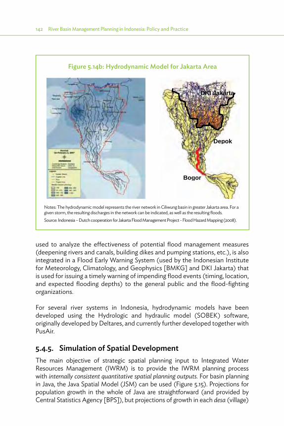
142 River Basin Management Planning in Indonesia: Policy and Practice
used to analyze the effectiveness of potential flood management measures (deepening rivers and canals, building dikes and pumping stations, etc.), is also integrated in a Flood Early Warning System (used by the Indonesian Institute for Meteorology, Climatology, and Geophysics [BMKG] and DKI Jakarta) that is used for issuing a timely warning of impending flood events (timing, location, and expected flooding depths) to the general public and the flood-fighting organizations.
For several river systems in Indonesia, hydrodynamic models have been developed using the Hydrologic and hydraulic model (SOBEK) software, originally developed by Deltares, and currently further developed together with PusAir.
5.4.5. Simulation of Spatial Development The main objective of strategic spatial planning input to Integrated Water Resources Management (IWRM) is to provide the IWRM planning process with internally consistent quantitative spatial planning outputs. For basin planning in Java, the Java Spatial Model (JSM) can be used (Figure 5.15). Projections for population growth in the whole of Java are straightforward (and provided by Central Statistics Agency [BPS]), but projections of growth in each desa (village)
Figure 5.14b: Hydrodynamic Model for Jakarta Area
DKI Jakarta
Depok
Bogor
Notes: The hydrodynamic model represents the river network in Ciliwung basin in greater Jakarta area. For a given storm, the resulting discharges in the network can be indicated, as well as the resulting floods. Source: Indonesia – Dutch cooperation for Jakarta Flood Management Project - Flood Hazard Mapping (2008).

Methodology of Basin Planning in Indonesia 143
and related land-use changes are more complicated. The JSM is used to provide spatial projections of population and associated land-use changes for each desa in Java, based on population (for Java) and economic growth projection (for province).
JSM 1 was first developed under the Basin Water Resources Management Planning (BWRMP) project in 2001–2002 and further developed in the “Space and Water” project (2006–2008). The latter is a spatial planning initiative covering all of Java, to support integration of spatial planning with water resources planning, and JSM 1 proved its usefulness there. Coverage of the whole of Java is necessary to reflect the migration flows in Java. In recent studies for the Asian Development Bank (ADB) (6 Cis) and World Bank (JWRSS), the JSM was updated to version JSM 2.2 (including data from 2010 population census). The model is used to provide internally consistent future projections of
(i) the spatial distribution of population and employment at the village level, (ii) the urban area growth needed to accommodate human activities, and (iii) the land-use changes caused by the urban area growth.
Figure 5.15: Overview of the Java Spatial Model
Input parameters Output variables2000–2050
Population projection Javahousehold and plot
Size projection by kabupaten Projections by kabupaten;Population, employment GDP
Housing area neededIndustrial area needed2. Spatial allocation submodel
(by desa)Multicriteria ranking of totalattractiveness for settlement:Accessibility, proximity (gravity),planning zones, land suitability,employment
Allocation of landLand use changes to allocate areaneeded, based on land availability andoverall attractiveness
All land allocated?
No Yes
Year
= Y
ear +
1
3. Postprocessor for indicatorsspace, water, agriculture
for desa, kecamatan, kabupaten,provinces, watersheds and water districts
Indicators for space, water, ecology, and agriculture
Input parametersFor water demands,
emissions, biodiversity, and foodproduction and consumption
1. Socioeconomic submodel(by kabupaten)
- population and employment growth (t)- GDP growth (t)- Total housing area needed (t)- Total industrial needed (t)
Initial situation (t=0)- Land use- Socioeconomic
Other parameters- Spatial plans and zones- Accessibility- Land price- Distances- Weight factors
Output variables by desa:- Land use (area and %)- attractiveness variables- Population and density
desa = village, GDP = gross domestic product, kabupaten = district, kecamatan = subdistrict.
Source: 6 Cis Final Report for B.2 (2012).

144 River Basin Management Planning in Indonesia: Policy and Practice
JSM provides in particular a consistent projection of urban/rural land use with important consequences for total water demand, water quality, and ecology, based on:
(i) socioeconomic projection of population and employment at the district (kabupaten) level based on economic growth scenarios,
(ii) spatial allocation of population and land use for Java at the village (desa) level, and(iii) calculation of impacts, based on a postprocessing on the population and
spatial allocation projection, resulting in impacts such as water demands, and pollutant emissions at different geographic levels (such as the 6Ci River Basin Simulation [RIBASIM] districts, desa, kecamatan, kabupaten, province, and island). The calculation of impact is based on the guidelines for river basin studies from the Ministry of Public Works (MPW).
With the high population growth in Java, land-use change is inevitable to accommodate human settlements and activities.
The driving factors for JSM projections are population growth for Java, expected household size reduction, increase in average area per household, economic growth by province and sector, and employment growth and change in economic structure. The background of the population and economic growth scenarios used are described in Section 5.6 (Forecasting). Base data were provided by the 2010 population census, with recent population data specified as detailed as for the subdistrict level. Innovative remote sensing techniques were used to prepare a 2010 land-use map as the starting point for the future trend projections with the latest version of JSM (JSM 2.2).

Methodology of Basin Planning in Indonesia 145
Figure 5.16: Growth of Urban Area
Note: Dark green shows rice fields and yellow shows the other agricultural areas.
Source: 6 Cis Final Report for B2 (2012).

146 River Basin Management Planning in Indonesia: Policy and Practice
The JSM can be used to derive the impacts of different scenarios for future development, specifying the impacts of assumed population and economic growth, government efficiency scenarios (relevant for protected areas in the spatial plan, and zoning policies). Impacts can be studied by comparing results with the base case. Figure 5.16 shows the impact on development of urban area in the Jakarta and Bandung area. Population, employment, land-use change, water demands, and so forth, are used directly in the IWRM analysis. The resulting impacts concern several aspects, and the following zoning policies were identified and analyzed:
(i) Food security zoning. Provide full protection (albeit limited by the governance efficiency) for irrigated paddy fields to preserve food production (in the June 2012 harmonized spatial plan, only about 70% is protected); this is addressed in Section 5.3.2.
(ii) Erosion protection zoning. This is done mainly in the upper catchment area to reduce erosion and related sedimentation, with an impact on sustainability of reservoir capacities and discharge capacities of rivers. This mainly focuses on identifying sensitive areas for erosion, based on slope, soil type, rainfall, land use, and land management, and subsequently stopping urban development in areas with slopes (>18%) and applying improved agricultural methods to protect the soil in other sensitive areas. This is addressed in Section 5.3.3.
(iii) Flood management zoning. This is the same as erosion protection zoning, but also includes specific policies to reduce peak flows. This involves specific building codes to be applied for the development of existing and/or new urban areas. This is specifically addressed in Section 5.3.4.
(iv) Protection of drinking water intakes and major structures. This focuses on the upstream watershed of the intakes so that the pollutant load can be controlled by prohibiting further urbanization. Without such zoning, the biological oxygen demand (BOD) pollutant load is projected to grow to 26% by 2030 and to 36% by 2050; this will lead to severe deterioration of water quality at the drinking water intakes.
5.4.6. Elaboration of Zoning5.4.6.1. Land-Use Management
With respect to water, the focus is on managing the erosion, infiltration, and retention characteristics of the catchment based, in particular, on the physical characteristics (slope, soil, rainfall intensity, and land use) of different areas in the catchment. For these physical processes, land use is important in terms of its cover of the soil and obstruction to runoff. Good management of the different land uses can substantially improve retention and infiltration and prevent erosion.
Depending on the characteristics of the location in relation to the water system, conditions may be imposed (management) on land use to create favorable

Methodology of Basin Planning in Indonesia 147
conditions for the water system. For very sensitive areas, certain land uses (or expansion of those) may be even prohibited (e.g., further settlement in areas which strongly contribute to rapid runoff and flood waves).
To derive zoning based on choices for protection and regulation, the following steps need to be incorporated into the analysis:
(i) identification of the problem area;(ii) establishment of the sensitivity of the phenomenon (e.g., flooding, erosion,
environmental degradation) for land-use changes: zoning should be able to differentiate and address the most sensitive areas;
(iii) identification and estimation of impacts (e.g., the impact of erosion in upper watershed is sedimentation in rivers and reservoirs, reducing their performance) in the present situation;
(iv) identification of potential measures such as rehabilitation or zoning; and(v) assessment of costs and benefits of the measures such as rehabilitation or
zoning to society, to decide on the type of measures or the level of control (criteria) in the zoning.
An example is presented in Figure 5.17.
Figure 5.17: Assessment of Water Management Problem— Example Upper Citarum Structuring
Strong catchment erosion; sedimentation (Saguling)
Identify most sensitive zones, and controls with
highest e�ectiveness
Formulation of adequate intervention; impact analysis
Estimate level of protection
Derive erosion sensitivityfor di�erent subareas and
land-use combinations;which will profit most from
rehabilitation
Example Upper Citarum
Di�erent levels of intervention and their impact
Upper Citarum: strong intervention(result: from 12.1 m3/year to 1.7 m3/year)
because of very high impact
Source: 6 Cis Final Report on B.2 (2012).
148 River Basin Management Planning in Indonesia: Policy and Practice
5.4.6.2. Modeling to Be Used in the Analyses
Quantification of sensitivity and impacts is essential to prepare a justifiable zoning. In the 6 Cis water zoning analysis, three models have been used to trace sensitivities and impacts:
(i) An estimation based on geographic information system (GIS) of erosion sensitivity using a special version of universal soil loss equation (USLE) soil loss prediction, including the effect of management interventions (database prepared for the whole of Java);
(ii) The hydraulic model SOBEK (1D-2D) to simulate the internal drainage behavior for the Jakarta region for different scenarios of land use and infiltration measures; and
(iii) A GIS-based storm water runoff model, indicating the areas of the catchment that contribute most to the peak flow, and delineating the area where extra attention should be paid to reduce or prevent land use with a large excess of rainfall, and where increasing retention will be most effective.
5.4.6.3. Proposed Water Zoning Related to Erosion and Runoff Protection
Based on (i) the objectives for zoning, (ii) the analysis of sensitivities for erosion and runoff and relationships with land use, and (iii) the relevant (major) land categories in the Bakosurtanal reference map, the following zoning is proposed to protect water-related interests:
1) An expanded conservation area (Kawasan Lindung) comprising:a. the current conservation area, b. reforestation in areas with slopes (>30%) (covers also areas with very
high erosion potential), andc. protection of bush/scrub areas.
2) Protection of dryland agriculture and improvement of infiltration and retention for sensitive zones for dryland agriculture (major contributor to erosion) defined by high erosion sensitivity of the bare soil.
3) Zone for protection of internal drainage (ΔQ=0 policy).4) Special protection zone for flood peak runoff.
Item 1): The measures to be taken for this expanded conservation zone include
(i) Where possible (in particular on state-owned lands) initiate reforestation; this includes reforestation of the recently deforested areas in the current conservation areas.
(ii) Protection of current bush and scrub areas (usually state owned) against possible further degrading; upgrading of those areas to (production) forest in the future.
(iii) Further settlement should be prevented.
Methodology of Basin Planning in Indonesia 149
Item 2): Measures to be taken for this zone:
(i) Improved management for agricultural areas, including permanent ground cover, mixed cropping, terracing, protection of slopes.
(ii) Measures to increase infiltration and reduce surface runoff in buildup areas (infiltration pits, retention ponds).
Item 3): Urban buildup creates excess rainfall and fast runoff, if left unchecked, requiring:
(i) ΔQ=0 policy implemented for new urban areas and upgrading of existing urban areas.
(ii) Building codes specifying sufficient compensating measures (retention, infiltration).
Item 4): Special protection of particular parts of catchment based on the hydrologic and hydraulic behavior:
(i) Reforestation, where possible. (ii) Improved management for agricultural activities.(iii) Natural depression and retention areas need to preserved; creation of extra
retention (this is the zone where retention has a maximum effect).(iv) Further settlement should be prevented unless in areas with slopes (<15%)
and with strict implementation of the ΔQ=0 policy.
5.4.7. Spatial Management for Control of Internal Drainage Figure 5.13 illustrated the different components of an integrated spatial and flood management, indicating the different spatial controls. A major distinction was made between internal and external drainage. Models have been set up to help outline zoning areas for flood management; application of modeling to derive zoning for internal drainage is illustrated below, while external drainage is discussed in Section 5.4.8.
The zoning concept for internal drainage is based on the ΔQ=0 concept—the increase in peak runoff due to increasing urbanization should be compensated by an increase in retention capacity and/or drainage discharge capacity. To determine such capacities, simulations were carried out with a hydrodynamic model. The hydrodynamic model allows for the testing of various scenarios and options. The hydrologic description of the subcatchments allows changing land use through an adaptation of the curve number, affecting the volume of excess rainfall and the runoff hydrograph (Soil Conservation Service).
Several simulations were carried out for the Jakarta region to analyze the effect of providing retention as well as to separate the contribution from the difficult
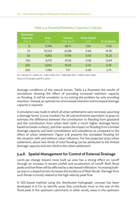
150 River Basin Management Planning in Indonesia: Policy and Practice
drainage conditions of the natural terrain. Table 5.4 illustrates the results of simulations showing the effect of providing increased retention capacity on flooding. It will be unrealistic to try solving the problem by only providing retention. Instead, an optimal mix of increased retention and increased drainage capacity is required.
A simulation was made in which all urban settlements were removed, assuming a drainage factor (curve number) for all subcatchments equivalent to grass to estimate the difference between the contribution to flooding from grassland and the contribution from urban land (with a much higher drainage factor based on harder surface), and then assess the impact on flooding from a limited drainage capacity and land consolidation and subsidence as compared to the effect of urban settlement. Figure 5.18 presents the simulated flooding for the situation with and without urban influence. For the projected 2030 urban settlement, about two-thirds of total flooding can be attributed to the limited drainage capacity and one-third to the urban settlement.
5.4.8. Spatial Management for Control of External Drainage Land-use change toward more built-up area has a strong effect on runoff through an increase in excess rainfall and acceleration of runoff. Both flood peaks and low flows will be affected by a decreased infiltration. Increasing built-up area in a sloped terrain increases the incidence of flash floods. Damage from such floods is mostly related to the high velocity peak flow.
A GIS-based method using the distributed hydrograph concept has been developed in 6 Cis to identify areas that contribute most to the size of the flood peak in the upstream catchment; in other words, areas in the upstream
Table 5.4: Potential Retention Capacity in Jakarta
Retention Capacity
(mm)Area (ha)
Volume (106 Mm3)
Mean Depth (m) % of Jakarta
0 11,194 68.71 0.61 17.3225 10,533 62.88 0.60 16.3050 9,853 57.94 0.59 15.25
100 8,170 47.65 0.58 12.64200 4,052 19.04 0.47 6.29300 1,780 7.17 0.40 2.75
ha = hectare, m = meter, m3 = cubic meter, mm = millimeter, Mm3 = million cubic meter.Source: 6 Cis project, part B-2 (2011).
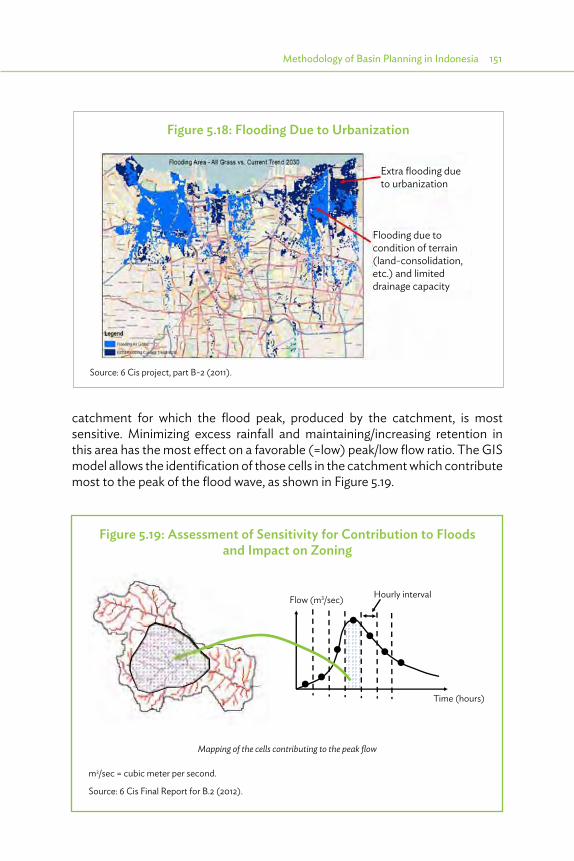
Methodology of Basin Planning in Indonesia 151
catchment for which the flood peak, produced by the catchment, is most sensitive. Minimizing excess rainfall and maintaining/increasing retention in this area has the most effect on a favorable (=low) peak/low flow ratio. The GIS model allows the identification of those cells in the catchment which contribute most to the peak of the flood wave, as shown in Figure 5.19.
Figure 5.18: Flooding Due to Urbanization
Source: 6 Cis project, part B-2 (2011).
Extra flooding due to urbanization
Flooding due to condition of terrain (land-consolidation, etc.) and limited drainage capacity
Figure 5.19: Assessment of Sensitivity for Contribution to Floods and Impact on Zoning
Time (hours)
Flow (m3/sec) Hourly interval
Mapping of the cells contributing to the peak flow
m3/sec = cubic meter per second.
Source: 6 Cis Final Report for B.2 (2012).

152 River Basin Management Planning in Indonesia: Policy and Practice
Figure 5.20: Translating Located Vulnerable Zone to Indication of Specific Zone in Spatial Plan
Source: 6 Cis Final Report for B.2 (2012).
Figure 5.21: Comparison of Hydrographs for Upper Ciliwung Catchment (Katulampa) for Different Land Uses
0
10
20
30
40
50
60
70
80
1 2 3 4 5 6 7 8 9 10 11 12
Time (hours)
m3 /s
ec
Current land-use Urbanized (current spatial plan)
Conservation zones (reforestation, agriculture)
Source: 6 Cis Final Report Component B.2 (2012).

Methodology of Basin Planning in Indonesia 153
Superimposition of this most sensitive area on the spatial planning map indicates the zoning (illustration to the upstream Ciliwung catchment, Figure 5.20). Figure 5.21 illustrates the response of the catchment to the application of this type of zoning.
5.4.9. Spatial Management for Catchment Conservation For the 6 Cis river basin territory, a primary concern in water management with increasing land-use intensity is to reduce peak flows and increase low flows and minimize erosion. Increasing settlements and encroachment for agricultural activities in high-sloped, erosion-sensitive areas have a particularly negative effect on the peak flows, low flows, and minimizing erosion: the changing catchment characteristics create a larger and faster runoff and larger erodibility. This has negative consequences for the area being eroded and for the downstream areas.
A particular urgent problem with erosion occurs in the Upper Citarum catchment and has been studied in the 6 Cis project. Serious erosion is threatening the productivity of the agricultural lands of the catchment. Also, the functioning of the Saguling reservoir is threatened by sedimentation of the eroded material, which has an even bigger impact because it is of high economic importance.
The conservation of catchment areas is required as land use often changes from dense forest to agriculture and settlements.
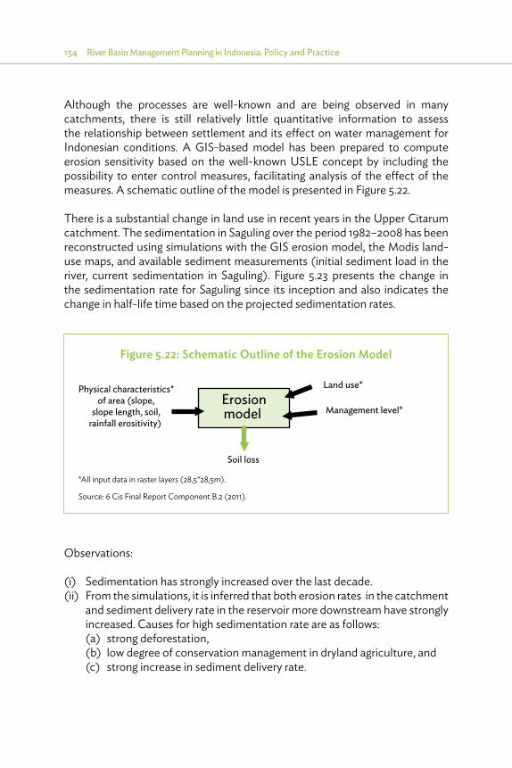
154 River Basin Management Planning in Indonesia: Policy and Practice
Although the processes are well-known and are being observed in many catchments, there is still relatively little quantitative information to assess the relationship between settlement and its effect on water management for Indonesian conditions. A GIS-based model has been prepared to compute erosion sensitivity based on the well-known USLE concept by including the possibility to enter control measures, facilitating analysis of the effect of the measures. A schematic outline of the model is presented in Figure 5.22.
There is a substantial change in land use in recent years in the Upper Citarum catchment. The sedimentation in Saguling over the period 1982–2008 has been reconstructed using simulations with the GIS erosion model, the Modis land-use maps, and available sediment measurements (initial sediment load in the river, current sedimentation in Saguling). Figure 5.23 presents the change in the sedimentation rate for Saguling since its inception and also indicates the change in half-life time based on the projected sedimentation rates.
Figure 5.22: Schematic Outline of the Erosion Model
Erosionmodel
Land use*
Management level*
Physical characteristics*of area (slope,
slope length, soil,rainfall erositivity)
Soil loss
*All input data in raster layers (28,5*28,5m).
Source: 6 Cis Final Report Component B.2 (2011).
Observations:
(i) Sedimentation has strongly increased over the last decade.(ii) From the simulations, it is inferred that both erosion rates in the catchment
and sediment delivery rate in the reservoir more downstream have strongly increased. Causes for high sedimentation rate are as follows:(a) strong deforestation,(b) low degree of conservation management in dryland agriculture, and(c) strong increase in sediment delivery rate.

Methodology of Basin Planning in Indonesia 155
(iii) Poor management of dryland agriculture, especially in the areas encroached in previous forests, which usually have high contributions to erosion.
(iv) At the current sedimentation rate, it is estimated that the remaining half-life time of the reservoir is 20 years (initial estimate was 189 years).
Figure 5.23: Estimated Sedimentation Rate for Saguling Reservoir
1982 20002.3
8.6
12.1
Sedimentation rate(mm3/year)
Time150 mm3
2004
Original half-lifetime: 189 years(2171)
Current remainhalf-life time: 20 years (2030)
mm3 = cubic millimeter.
Source: 6 Cis Final Report Component B.2 (2011).
Table 5.5: Estimated Impact of Saguling Losing All of Its Storage
Reduction of energy $84 million/year
Loss of firm peak power $105 million/year
Loss of firm water supply downstream $2 million/year
Total damage $191 million/year
Source: 6 Cis Final Report Component B.2 (2011).
The impact of Saguling losing its storage capacity is very high; Table 5.5 gives an overview of the impact on the generation of hydropower and downstream firm water supply.
In view of this huge impact, strong intervention is justified, which should substantially prolong the lifetime of Saguling and prevent damage as much as possible. The intervention consists of two components:
(i) rehabilitation of a considerable part of the catchment, to bring it to a desired state of low erosion (high management), and
(ii) zoning of the catchment to conserve the upgraded status of the catchment for a long time.

156 River Basin Management Planning in Indonesia: Policy and Practice
5.4.9.1. Rehabilitation Program to Reduce Erosion
A rehabilitation program was identified, which will reduce the sedimentation rate by 12.2 megatons/year. This will increase the remaining half-life time to 110 years. Based on several simulations with the erosion model, the erosion sensitivity for different land uses in different subbasins was determined. Subsequently, the effect of improving the areas was determined, and a ranking was made of the areas which could best contribute to the target sediment reduction. Table 5.6 presents the most effective measures (land use, subbasin location) to be included in the catchment rehabilitation program. The measures comprise two components: a proposed reforestation component and a component for improved management of dryland agriculture.
Table 5.6: Overview of Measures and Cost for Watershed Conservation Measures
Rehabilitation Measures
Area (ha)
Efficiency (ton/ha/
year)
Reduction (Mton/
year) Land Use SubbasinReforestation > 30 25,032 234 5.20 Plantation All subbasinsImproved management 1
1,291 246 0.31 Plantation Citarik
2 4,731 207 0.98 Dryland Cikapundung3 6,744 207 1.40 Dryland Citarum hulu4 4,803 177 0.85 Dryland Citarik5 7,433 152 1.14 Dryland Cikapundung6 3,603 139 0.50 Plantation Citarum hulu
7 1,253 136 0.17 Plantation Cihaur8 3,728 127 0.47 Dryland Cihaur9 8,322 116 0.96 Plantation Cimunyak
10 2,370 94 0.22 Plantation CisangkuyTotal 69,310 12.20
ha = hectare, Mton = megaton.
Source: 6 Cis Final Report Component B.2 (2011).
5.4.9.2. Protection Zoning for Long-Term Conservation
The rehabilitated catchment should be conserved to maintain low erosion over the long term. The proposed zoning consists of two zones as illustrated in Figure 5.24.

Methodology of Basin Planning in Indonesia 157
•� reforestation zone in areas with slopes (>30%): in this very sensitive zone, existing forests should be maintained and reforestation should take place as much as possible; and
•� a sensitive zone for dryland agriculture (a major contributor to erosion) defined by high erosion sensitivity of the bare soil (erosion potential >500 ton/ha/year), where more proactive conservation management should take place.
5.4.10. Evaluation of Priorities (Pola) and Cost and Benefits (Rencana)
5.4.10.1. Importance of Setting Priorities
The effectiveness of the Pola and Rencana is enhanced by prioritizing certain measures, which ensures mobilizing of limited resources for the most promising measures. The problem is how to select these priorities in a rational
Figure 5.24: Zoning for Agricultural Protection (light green) and Expanded Conservation Zone (dark green)
Source: 6 Cis Final Report Component B.2 (2011).

158 River Basin Management Planning in Indonesia: Policy and Practice
and transparent way so that all parties can understand and contribute to a comprehensive but convergent process.
For the Pola, the priority ranking is more or less based on insight knowledge and expert judgments. This is sufficient for strategic decisions based on aggregate information. For the Rencana, the cost and benefits of measures and strategies will play a role, allowing a more detailed assessment.
5.4.10.2. Cost-Benefit Comparison
The costs can generally be estimated. Not all benefits, however, can be estimated easily. In the Rencana, either the optimal cost-benefit ratio (where benefits are clear) or the least cost (in case benefits are less clear) is sought. A least cost approach, however, should also include any changes in benefits in various sectors. The following example will make this clear: consider the bulk water supply to an urban area in a basin where available water resources are already intensively used (which is true for virtually any city in Java). For obvious reasons, DMI supply is of very high priority. This implies that a cost-benefit analysis is not really required, irrespective of the possibility to accurately estimate the benefits of drinking water supply. Hence, a least cost approach is sufficient. However, such a least cost approach should include any change in the economic benefits of irrigated agriculture, as well as any change in the economic benefits of hydropower generation. Furthermore, such a least cost approach should also include pumping costs and the operational costs for drinking water treatment plants, in particular if the quality of the raw water in various alternatives differs significantly (treatment of water from more polluted sources is, of course, more expensive when compared with unpolluted sources). To summarize, a least cost approach for DMI supply should not just focus on investment costs but also include operational costs and water treatment costs.
This subsection discusses approaches to estimating costs and benefits of various types of water resources measures.
5.4.10.3. Definition and Objective of Cost Estimating Relationships
A cost estimating relationship (CER) links the investment costs for a certain type of infrastructure development project to one or more relevant characteristics of that project. If sufficiently accurate, such a relationship allows for a quick and easy comparison between several alternative measures. They can also be used to estimate the total costs for an alternative strategy (a group of measures).
Unified cost estimation is very important to compare the various measures consistently. Often, cost estimates from individual (pre-)feasibility studies remain unclear as to the exact basis for cost estimates. It is not always clear
Methodology of Basin Planning in Indonesia 159
whether the cost estimate from individual (pre-)feasibility study includes cost for engineering, administration, and physical (EAP) contingencies, land acquisition, operation and maintenance (O&M), energy costs for pumping station, hydropower generation benefits, etc. The use of CER offers a unified knowledge base.
CERs can be derived from earlier design studies for comparable projects. By means of statistical analysis, a relation is found between project characteristics and costs. One has to make sure that the price level of cost figures from various studies is brought to one and the same price level, such as the price level of the same reference year, financial prices or economic prices, taxes included or not, etc. Also, for all projects and CERs considered, a similar approach should be followed regarding taxes, EAP contingencies. For the 6 Cis project, the following approach was chosen:
(i) All CERs are for the price level of 2010.(ii) Value-added tax (VAT) is not included in the CERs.(iii) EAP contingencies are included in the CERs.
There are two important sources for CERs of particular relevance for estimating project costs in the 6 Cis project area:
(i) The study, Cisadane-Cimanuk Integrated Water Resources Development (BTA155), was carried out in the mid-1980s for Western Java. This project is generally known as the BTA155 project (Integrated Water Resources Study for Cimanuk - Cidurian [BTA155] [Delft Hydraulics, 1989]).
(ii) Jabotabek Water Resources Management Study (JWRMS) was carried out in the early 1990s for roughly the same area as the 6 Cis study (JWRMS [1994]).
In these projects, extensive data collection and statistical analysis resulted in sets of CERs for various structural measures.
In the framework of the 6 Cis project, the CERs from BTA155 and JWRMS were enriched with cost information on projects carried out since the 1990s. Furthermore, foreign and local price escalations were taken into account, and adjustments were made to reach the 2010 price level. This resulted in CERs for the 6 Cis project, as shown in Table 5.7.
It should be well understood that CERs have to be used with care. First of all, it should be noted that CERs result from statistical analysis in which only a limited number of parameters are included. Hence, CERs should not be used when reliable and detailed cost estimates are available from a feasibility study for a project under consideration. Second, CERs developed for a particular area
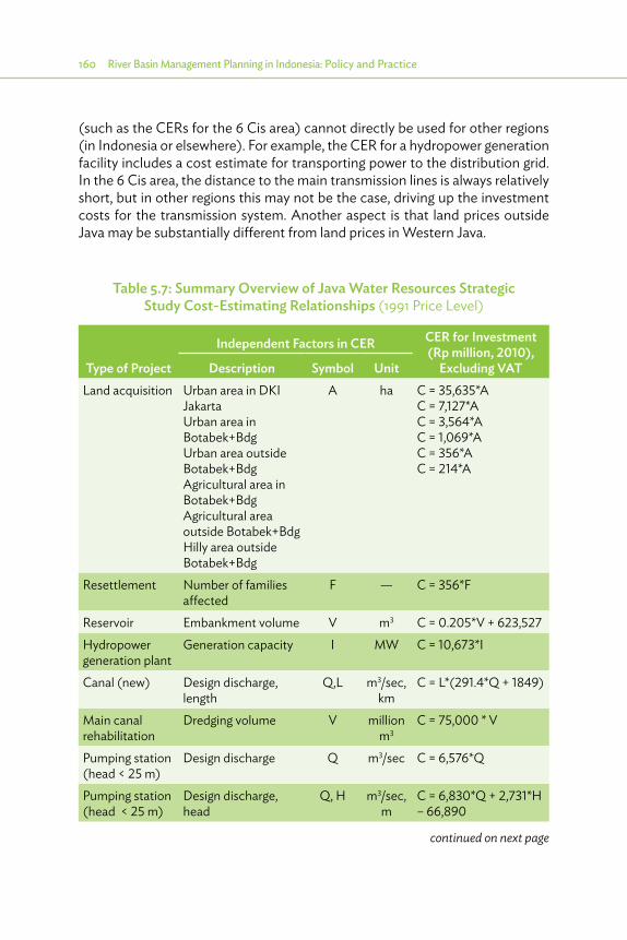
160 River Basin Management Planning in Indonesia: Policy and Practice
(such as the CERs for the 6 Cis area) cannot directly be used for other regions (in Indonesia or elsewhere). For example, the CER for a hydropower generation facility includes a cost estimate for transporting power to the distribution grid. In the 6 Cis area, the distance to the main transmission lines is always relatively short, but in other regions this may not be the case, driving up the investment costs for the transmission system. Another aspect is that land prices outside Java may be substantially different from land prices in Western Java.
continued on next page
Table 5.7: Summary Overview of Java Water Resources Strategic Study Cost-Estimating Relationships (1991 Price Level)
Type of Project
Independent Factors in CER CER for Investment (Rp million, 2010),
Excluding VATDescription Symbol UnitLand acquisition Urban area in DKI
JakartaUrban area in Botabek+BdgUrban area outside Botabek+BdgAgricultural area in Botabek+BdgAgricultural area outside Botabek+BdgHilly area outside Botabek+Bdg
A ha C = 35,635*AC = 7,127*AC = 3,564*AC = 1,069*AC = 356*AC = 214*A
Resettlement Number of families affected
F — C = 356*F
Reservoir Embankment volume V m3 C = 0.205*V + 623,527Hydropower generation plant
Generation capacity I MW C = 10,673*I
Canal (new) Design discharge, length
Q,L m3/sec, km
C = L*(291.4*Q + 1849)
Main canal rehabilitation
Dredging volume V million m3
C = 75,000 * V
Pumping station(head < 25 m)
Design discharge Q m3/sec C = 6,576*Q
Pumping station(head < 25 m)
Design discharge, head
Q, H m3/sec, m
C = 6,830*Q + 2,731*H – 66,890
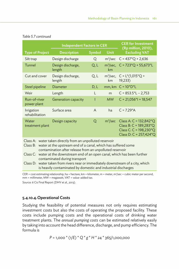
Methodology of Basin Planning in Indonesia 161
Table 5.7 continued
Type of Project
Independent Factors in CER CER for Investment (Rp million, 2010),
Excluding VATDescription Symbol UnitSilt trap Design discharge Q m3/sec C = 437*Q + 2,636Tunnel Design discharge,
lengthQ, L m3/sec,
kmC = 723*Q + 55,673*L
Cut and cover Design discharge, length
Q, L m3/sec, km
C = L*(1,015*Q + 19,233)
Steel pipeline Diameter D, L mm, km C = 10*D*LWeir Length L m C = 853.5*L – 2,753Run-of-river power plant
Generation capacity I MW C = 21,056*I + 18,547
Irrigation rehabilitation
Surface area A ha C = 7.29*A
Water treatment plant
Design capacity Q m3/sec Class A: C = 132,842*QClass B: C = 189,283*QClass C: C = 198,230*QClass D: C = 257,424*Q
Class A: water taken directly from an unpolluted reservoirClass B: water at the upstream end of a canal, which has suffered some
contamination after release from an unpolluted reservoirClass C: water at the downstream end of an open canal, which has been further
contaminated during transportClass D: water taken from rivers near or immediately downstream of a city, which
is heavily contaminated by domestic and industrial dischargesCER = cost estimating relationship, ha = hectare, km = kilometer, m = meter, m3/sec = cubic meter per second, mm = millimeter, MW = megawatt, VAT = value-added tax.Source: 6 Cis Final Report (DHV et al., 2013).
5.4.10.4. Operational Costs
Studying the feasibility of potential measures not only requires estimating investment costs but also the costs of operating the proposed facility. These costs include pumping costs and the operational costs of drinking water treatment plants. The annual pumping costs can be estimated relatively easily by taking into account the head difference, discharge, and pump efficiency. The formula is
P = 1,000 * (1/E) * Q * g * H * 24 * 365/1,000,000
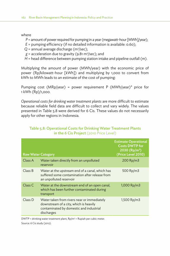
162 River Basin Management Planning in Indonesia: Policy and Practice
where P = amount of power required for pumping in a year (megawatt-hour [MWh]/year); E = pumping efficiency (if no detailed information is available: 0.60); Q = annual average discharge (m3/sec); g = acceleration due to gravity (9.81 m3/sec); and H = head difference between pumping station intake and pipeline outfall (m).
Multiplying the amount of power (MWh/year) with the economic price of power (Rp/kilowatt-hour [kWh]) and multiplying by 1,000 to convert from kWh to MWh leads to an estimate of the cost of pumping:
Pumping cost (MRp/year) = power requirement P (MWh/year)* price for 1 kWh (Rp)/1,000.
Operational costs for drinking water treatment plants are more difficult to estimate because reliable field data are difficult to collect and vary widely. The values presented in Table 5.8 were derived for 6 Cis. These values do not necessarily apply for other regions in Indonesia.
Table 5.8: Operational Costs for Drinking Water Treatment Plants in the 6 Cis Project (2010 Price Level)
Raw Water Category
Estimate Operational Costs DWTP for
2030 (Rp/m3)(Price Level 2010)
Class A Water taken directly from an unpolluted reservoir
200 Rp/m3
Class B Water at the upstream end of a canal, which has suffered some contamination after release from an unpolluted reservoir
500 Rp/m3
Class C Water at the downstream end of an open canal, which has been further contaminated during transport
1,000 Rp/m3
Class D Water taken from rivers near or immediately downstream of a city, which is heavily contaminated by domestic and industrial discharges
1,500 Rp/m3
DWTP = drinking water treatment plant, Rp/m3 = Rupiah per cubic meter.Source: 6 Cis study (2012).
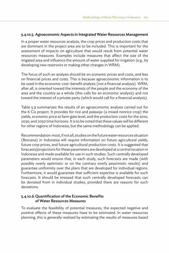
Methodology of Basin Planning in Indonesia 163
5.4.10.5. Agroeconomic Aspects in Integrated Water Resources Management
In a proper water resources analysis, the crop prices and production costs that are dominant in the project area are to be included. This is important for the assessment of impacts on agriculture that would result from potential water resources measures. Examples include measures that affect the size of the irrigated area and influence the amount of water supplied for irrigation (e.g., by developing new reservoirs or making other changes in WRM).
The focus of such an analysis should be on economic prices and costs, and less on financial prices and costs. This is because agroeconomic information is to be used in the economic cost–benefit analysis (not a financial analysis). WRM, after all, is oriented toward the interests of the people and the economy of the area and the country as a whole (this calls for an economic analysis) and not toward the interest of a private party (which would call for a financial analysis).
Table 5.9 summarizes the results of an agroeconomic analysis carried out for the 6 Cis project. It provides for rice and palawija (a mixed nonrice crop) the yields, economic price at farm gate level, and the production costs for the 2010, 2030, and 2050 time horizons. It is to be noted that these values will be different for other regions of Indonesia, but the same methodology can be applied.
Recommendation: most, if not all, studies on the future water resources situation (Rencana) in Indonesia will require information on future agricultural yields, future crop prices, and future agricultural production costs. It is suggested that forecasts/projections for these parameters are developed at a central location in Indonesia and made available for use in such studies. Such centrally developed parameters would ensure that, in each study, such forecasts are made (with possibly overly optimistic or on the contrary overly pessimistic results) and guarantee uniformity over the plans that are developed for individual regions. Furthermore, it would guarantee that sufficient expertise is available for such forecasts. It should be stressed that such centrally developed forecasts can be deviated from in individual studies, provided there are reasons for such deviations.
5.4.10.6. Quantification of the Economic Benefits of Water Resources Measures
To evaluate the feasibility of potential measures, the expected negative and positive effects of these measures have to be estimated. In water resources planning, this is generally realized by estimating the results of measures based
164 River Basin Management Planning in Indonesia: Policy and Practice
Table 5.9: Agroeconomic Analysis
Irrigation Rehabilitation
Base Case 2010
Base Case 2030
Base Case 2050 Unit
Sawah paddy potential yield
No 5.62 6.47 7.42 t/ha
Yes 7.47 8.42 t/haAverage palawija potential yield
No 2.55 2.94 3.37 t/ha
Yes 4.19 4.62 t/haEconomic price sawah paddy (farm gate)
2,627 2,126 2,126 Rp/kg
Economic price palawija (farm gate)
2,955 2,975 2,975 Rp/kg
Economic production costs sawah paddy
No 4.98 5.51 6.19 Rp million /ha
Yes 6.23 7.02 Rp million /ha
Economic production costs palawija
No 2.55 2.82 3.07 Rp million /ha
Yes 3.83 4.09 Rp million /ha
ha = hectare, kg = kilogram, palawija = non-rice crops, Rp = rupiah, t = ton, sawah = rice field. Source: 6 Cis study (2012).
on a variety of decision criteria such as financial and economic costs, economic benefits, environmental consequences, effects on employment, poverty alleviation, gender issues, etc.
As part of the evaluation of proposed measures, the cost-benefit ratio is generally used as an indicator for how well a measure performs on economic aspects. For the costs of measures, available feasibility or design studies can be used or, alternatively, a set of CERs, outlined earlier in this chapter, can be used. For the quantification of the economic benefits of water resources measures and strategies, it proves useful to make a distinction between the various types of measures, since for some types of measure it is not easy to assess the benefits,

Methodology of Basin Planning in Indonesia 165
and to discuss for each type of measure whether or not it is feasible to estimate the economic benefits of measures. In case such quantification is feasible, the next step is to reach an agreement on how to quantify these benefits.
The 6 Cis project made a distinction between the following types of measures:
(i) benefits of projects that supply water to Perusahaan Daerah Air Minum - local water utilities company,
(ii) benefits of watershed restoration projects,(iii) benefits of irrigation rehabilitation projects,(iv) benefits of (changes in) hydropower generation,(v) benefits of institutional measures,(vi) benefits of flood damage mitigation measures, and (vii) benefits of coastal erosion abatement measures.
Table 5.10 summarizes the outcome of estimating economic benefits of these types of measures in the 6 Cis project. For some measures, it is concluded that the topic is too complicated or uncertain for a quantification of economic benefits. For other sectors, quantification proves possible. Reference is made to the 6 Cis reports for more information.
5.4.11. State of the Basin Reporting Regular reporting on the state of the basins aims to compare the condition of the basins, based on a number of selected indicators, and also aims to identify basins that could be cited as examples for other basins for some selected aspects, if not all. The state of the basin report could also be used for the 5-year review of the Pola and Rencana.
River basin status reporting, which concentrates on the physical conditions of the basin, builds further on the performance benchmarking started for river basin organizations (RBOs), which concentrates on the institutions involved. The Network of Asian River Basin Organizations (NARBO), in close cooperation with International Water Management Institute (IWMI) and ADB, introduced performance benchmarking of RBOs as a tool to enhance effective implementation of Integrated Water Resources Management (IWRM), comprising a limited number of indicators for performance assessment of RBOs. One cannot attribute the whole IWRM performance to the functioning of RBOs, as the physical status of a basin should also be paid much attention to. Therefore, NARBO, with ADB and University of Tokyo, initiated a pilot for physical basin performance benchmarking (PBPB) in the Citarum basin, referred to as “the Saikei approach.” The consultants for the 6 Cis project (TA 7189 - Package B) further assessed the possibilities for PBPB, starting with the indicators identified
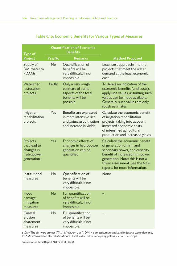
166 River Basin Management Planning in Indonesia: Policy and Practice
Table 5.10: Economic Benefits for Various Types of Measures
Type of Project
Quantification of Economic Benefits
Method ProposedYes/No RemarksSupply of DMI water to PDAMs
No Quantification of benefits will be very difficult, if not impossible.
Least cost approach: find the projects that meet the water demand at the least economic cost.
Watershed restoration projects
Partly Only a very rough estimate of some aspects of the total benefits will be possible.
To derive an indication of the economic benefits (and costs), apply unit values, assuming such values can be made available. Generally, such values are only rough estimates.
Irrigation rehabilitation projects
Yes Benefits are expressed in more intensive rice and palawija cultivation and increase in yields.
Calculate the economic benefit of irrigation rehabilitation projects, taking into account increased economic costs of intensified agricultural production and increased yields.
Projects that lead to changes in hydropower generation
Yes Economic effects of changes in hydropower generation can be quantified.
Calculate the economic benefit of generation of firm and secondary power, and capacity benefit of increased firm power generation. Note: this is not a trivial assessment. See the 6 Cis reports for more information.
Institutional measures
No Quantification of benefits will be very difficult, if not impossible.
None
Flood damage mitigation measures
No Full quantification of benefits will be very difficult, if not impossible.
–
Coastal erosion abatement measures
No Full quantification of benefits will be very difficult, if not impossible.
–
6 Cis = The six rivers project (TA 7189) (2009–2013), DMI = domestic, municipal, and industrial water demand, PDAMs =Perusahaan Daerah Air Minum - local water utilities company, palawija = non-rice crops.
Source: 6 Cis Final Report (DHV et al., 2013).

Methodology of Basin Planning in Indonesia 167
in that pilot. These indicators were divided in key performance areas, indicators (index) and subindicators as shown in Table 5.11. It should be noted that the Saikei approach concentrates on environmental aspects and requires many ecosystem data, which are not yet routinely collected. Therefore, it was assumed that this approach was not suitable.
Instead, the 6 Cis Package B consultants focused on the development of a performance benchmarking tool covering all physical aspects mentioned in Law 7/2004 (conservation, utilization, and disaster management) and an appropriate process and guidelines to produce and disseminate a “state of the basin” report to identify problem areas, cause/sources, and needed remedies. The tool was developed in October 2011 and was discussed during a workshop in May 2012 with B(B)WS Citarum. All these activities should contribute to more information for the planning process and annual updating of BWRMP. Cooperation with NARBO and ICWRMO and other networks will be instrumental for the assessment of best practices, exchange with other organizations involved in IWRM, and dissemination of the results.
Table 5.11: Key Performance Areas, Indices, and Subindicators of Basin Status Benchmarking
Key Performance Area
Index Subindicators
Water utilization Recreational water quality Fecal coliformRaw water supply Annual water supply planning ratio
Water supply planning ratio in extreme conditions
Disaster vulnerability
Flood preparedness Average number of people killed in flood events
Chemical spills Cadmium and zincEnvironmental management
Environmental water quality
Total phosphorousAmmonia nitrogenDissolved oxygen
Biodiversity Observed and expected number of species of fishObserved and expected number of species of macroinvertebrateObserved and expected number of species of aquatic plants
Source: Saikei. 2004. University of Tokyo.

168 River Basin Management Planning in Indonesia: Policy and Practice
Table 5.12 comprises the results of the May 2012 workshop, which give an overview of the critical performance areas (CPAs), the objectives for the different CPAs, and the indicators selected to measure the performance. Although more detailed assessment sheets have been prepared, a final tool has not yet been developed, because it proved difficult to organize a tryout.
Table 5.12: Proposed Framework for Physical River Basin Performance Benchmarking
Critical Performance Areas Objectives Indicators and MeasuresI. Conservationa. Catchment area Protection of catchment area 1. Erosion of topsoil
2. Condition of riverbanks3. Water retention capacity
b. Water quality Improved water quality or water quality up to standard
Chemical pollution
c. Biodiversity Monitoring adequate biodiversity
1. Mean Species Abundance
II. Water Utilizationa. Water balance Sufficient water resources
available to meet demand1. Water available
for water supply2. Water available
for irrigation b. Conveyance
systemSufficient water at the right time, right place, in right quantity
1. Efficiency
c. Groundwater Sustainable use of groundwater
1. Groundwater level2. Zoning of groundwater3. Composition
III. Water-Related Damagea. Floods Improved protection levels
and/or reduced damage1. Inundation areas2. Embankment
b. Landslides Prevent landslides from forestation and vegetation removal
1. Transverse, tension cracks, or unusual bulges
2. Tilted or bent trees3. Springs, seeps, or saturated
groundSource: DHV et al. for the 6 Cis project, (TA 7189 INO, Package B).

Methodology of Basin Planning in Indonesia 169
5.5. Water Quality: Management, Cost, and Benefits
5.5.1. Overall Approach Usually, water quality management only comprises monitoring of data, while hardly any follow-up action is taken to improve the situation if the records show degradation. The 6 Cis project (TA 7189 INO, Package B) provided a model for water quality management, comprising an example for analysis of the data, and possible interventions where problems were detected. This section shows the results: determination of the level of pollution, origin of pollution, possible interventions, and cost and benefits of these interventions. Related costs for implementation and envisaged benefits have been assessed and they indicate a favorable cost–benefit ratio of more than 2.
More specifically, the following steps were undertaken:
(i) determine the water quality at different locations over time in the Upper Citarum River;
(ii) determine the source of pollution, differentiating domestic–municipal sources, industrial sources, and agricultural sources;
(iii) determine the types of interventions (wastewater treatment and solid waste) as well as related costs;
(iv) determine the expected water quality and the result of certain interventions focusing on the reduction of domestic–municipal and/or industrial wastewater treatment using River Basin Simulation (RIBASIM);
(v) determine the benefits in terms of improved water quality and also in economic terms; and
(vi) present a road map on how to improve the water quality in the Citarum River.
5.5.2. Determination of Water Quality in Upper Citarum RiverWater quality in the Citarum River is determined through measurements of the Provincial Bureau of Environment (BPLHD). For this case study, only the biological oxygen demand (BOD), chemical oxygen demand (COD), nitrogen, and phosphorus values were applied.
5.5.3. Determination of Discharge of Pollution (Loads and Flows)
Contributions from several sources are as indicated in Figure 5.25. It shows that the major part of pollution is produced by domestic–municipal activities (65% for COD), followed by industrial (30% for COD) and finally, agricultural–irrigation (6%) activities.

170 River Basin Management Planning in Indonesia: Policy and Practice
Figure 5.25: Pollutant Discharge per Water District for Domestic, Municipal, Industrial, and Agricultural Activities
COD (ton/day)
BOD(ton/day)
N(ton/day)
P(ton/day)
Domestic- municipal 343 128 84 19
Industry 159 55 9 3
Agriculture 34 17 16 5
COD(ton/day)
BOD(ton/day)
N(ton/day)
P(ton/day)
Domestic- municipal 64% 64% 77% 71%
Industry 30% 27% 8% 11%
Agriculture 6% 8% 15% 18%
Total Pollutant discharge in upper WS Citarum
COD discharge per water district
0
100
200
300
400
500
600
COD BOD N P
Ton/
d CO
D, B
OD
, N, a
nd P
DM Industry Agriculture
0%
20%
40%
60%
80%
100%
COD BOD N P
Rela
tive
cont
ribut
ion
DM
, Ind
and
Ag
ri.
DM Industry Agriculture
0
50,000
100,000
150,000
200,000
250,000
D.301D.302
D.32 1D.32 2
D.323D.324
D.325D.330
D.328
kg C
OD
/day
DM Industry Agriculture
010,00020,00030,00040,00050,00060,00070,00080,00090,000
D.301D.302
D.321D.322
D.323D.324
D.32 5D.330
D.328
kg C
OD
/day
DM Industry Agriculture
Relative contribution of each activity
BOD discharge per water district
BOD = biological oxygen demand, COD = chemical oxygen demand, N = nitrogen, P = phosphorus, WS = Wilayah Sungai.
Source: 6 Cis Final Report (2013).
Three sources of pollution were identified: domestic, industry, and agriculture. Law enforcement and action need to be taken when the water quality is deteriorating.

Methodology of Basin Planning in Indonesia 171
This large contribution of domestic–municipal activities is related to the huge number of people lacking access to improved sanitation. In rural areas, coverage is about 40%, whereas in the urban areas this increases only to 65%, dependent mainly on septic tanks, with only some 5% of the population being connected to a centralized wastewater treatment plant (WWTP). Most of the larger industries have some form of WWTP, but performance standards are disappointingly low, while the situation is even worse in the case of smaller WWTPs.
5.5.4. Determination of Intervention to Reduce Pollution 5.5.4.1. Domestic–Municipal Interventions
Three types of main systems are distinguished: on-site systems, community-based systems, and off-site systems. The features of each of these systems are presented in Table 5.13 (Urban Sanitation Development Project [DHV et al. 2012]).
Following the approach developed under the Urban Sanitation Development Project (USDP), the feasibility for application depends on the combination of population density, urban functions, as well as groundwater problems. In the current project, the last criterion is assumed to be of less importance. Selection of each technology is done based on Figure 5.26 (USDP 2012).
Table 5.13: Overview and Features of Applicable Sanitation Options in the Indonesian Context
Main Category
On-Site Systems
Hybrid: Community- Based systems Off-Site
Subdivision: •�Shared•� Individual (Ind.)
•� Sanimas: Settler+ ABR+ An.filter•� MCK++-with connections
•� Medium: de-central•�Centralized
User interface
No running water required
Running water/ poor flush toilets preferred
Running (tap) water required
Transport system
No sewer system Small-scale sewer system Simplified/ conventional sewer system
Treatment system
Containment/septic tank
Sanimas: Septic tank/ABR + Filter MCK+: digester + ABR+ Filter
Anaerobic, aerobic or pond systems
Final disposal
Centralized sludge treatment system (IPLT) Sludge treatment on site of WWTP
Example picture
ABR = anaerobic baffled reactor, IPLT= Instalasi Pengolahan Air Limbah Terpadu- centralized sludge treatment system, MCK= Mandi Cuci Kakus- basic communal sanitation facilities, WWTP = Wastewater Treatment PlanSource: Urban Sanitation Development Project (2012).

172 River Basin Management Planning in Indonesia: Policy and Practice
Figure 5.26: Decision Model on Feasibility of Type of Wastewater Treatment System
Population density (ppha) <25 25–100 100–175 175–250 >250
Urban Function (e.g., CBD) no* no yes no yes no yes
yes*Good physical conditions(gwl >= 0.30 m below GL, no major flooding)
yes no yes no yes no yes no yes no yes*
1.0 On site
1.1 Individual1.2 Shared (MCK+ 0R ++)2.0 Community/hybrid2.1 Communal septic tank
2.2 Small de-central (sanimas)
2.3 MCK++ incl. small de-central3.0 O�-site
3.1 Medium de-central
3.2 Central
Preferred Optional* It is yes or no but there are alternative measures with special consideration.
CBD = Central Business District, GL= Ground Level, gwl = Ground Water Level, MCK = Mandi Cuci Kakus- basic communal sanitation facilities, ppha= people per hectare.
Source: Urban Sanitation Development Project (DHV 2012).
Table 5.14: Assumed Removal Efficiencies in Water Treatment Systems
System
Removal (%) On-Sitea (%) Community Basedb (%)
Off-Site 2010c (%)
Off-Site 2030d (%)
COD 30 60 65 85BOD 40 70 65 90TN 5 5 80 80TP 5 5 55 70Fecal coliforms 75 95 99.99 99.999
BOD = biological oxygen demand, COD = chemical oxygen demand, TN = Total Nitrogen, TP = Total Phosphorus.Sources:a Mgana, S.M. (2003) Phd Thesis: Towards Sustainable and Robust Community on-Site Domestic Wastewater
Treatment. Wageningen University, Tchobanoglous et al. (2004).b Ulrich, A., Reuter, S., Gutterer, B., Sasse, L., Panzerbieter, T. and Reckerzuegel, T. (2009) Decentralised
Wastewater Treatment Systems ( DEWATS ) and Sanitation in Developing Countries. A Practical Guide. Loughborough, UK: WEDC in association with BORDA
b Kerstens, S.M., Legowo, H.B. & Hendra Gupta, I.B. (2012) Evaluation of DEWATS in Java, Indonesia. Journal of Water, Sanitation and Hygiene for Development 2 (4). 254
b Tchobanoglous, G., Burton, F.L. and Stensel, H.D. (2003) Wastewater Engineering: Treatment and Reuse. New York: McGraw-Hill, Inc.
c Bojong Soang (2012) Bojong Soang WWTP Access Data Obtained from a Visit to the Plant.d Author’s estimate.
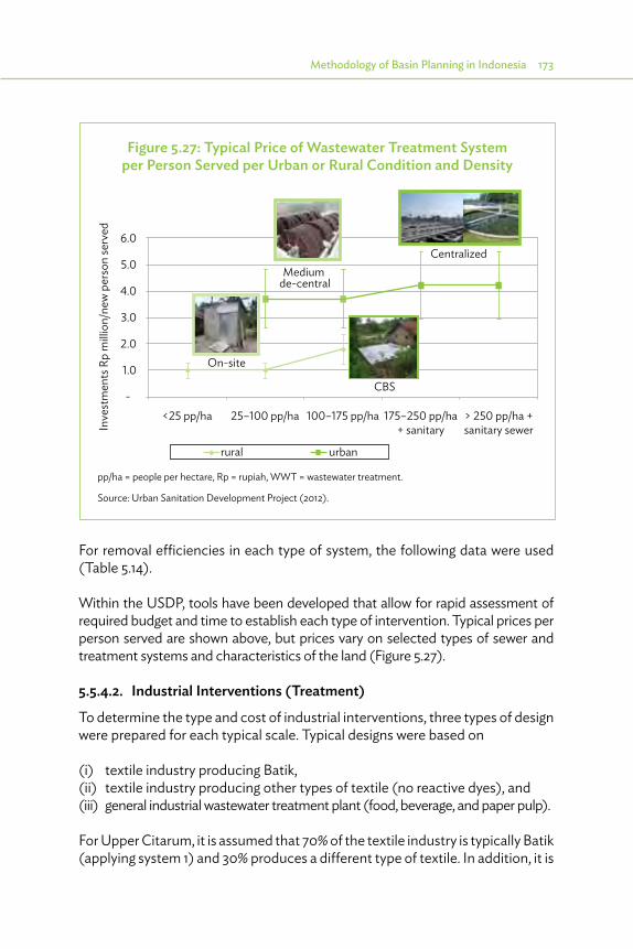
Methodology of Basin Planning in Indonesia 173
Figure 5.27: Typical Price of Wastewater Treatment System per Person Served per Urban or Rural Condition and Density
CBS
urbanrural
6.0
Inve
stm
ents
Rp
mill
ion/
new
per
son
serv
ed
5.0
4.0
3.0
2.0
1.0
<25 pp/ha 25–100 pp/ha 100–175 pp/ha 175–250 pp/ha+ sanitary
> 250 pp/ha +sanitary sewer
-
Medium de-central
Centralized
On-site
pp/ha = people per hectare, Rp = rupiah, WWT = wastewater treatment.
Source: Urban Sanitation Development Project (2012).
For removal efficiencies in each type of system, the following data were used (Table 5.14).
Within the USDP, tools have been developed that allow for rapid assessment of required budget and time to establish each type of intervention. Typical prices per person served are shown above, but prices vary on selected types of sewer and treatment systems and characteristics of the land (Figure 5.27).
5.5.4.2. Industrial Interventions (Treatment)
To determine the type and cost of industrial interventions, three types of design were prepared for each typical scale. Typical designs were based on
(i) textile industry producing Batik,(ii) textile industry producing other types of textile (no reactive dyes), and(iii) general industrial wastewater treatment plant (food, beverage, and paper pulp).
For Upper Citarum, it is assumed that 70% of the textile industry is typically Batik (applying system 1) and 30% produces a different type of textile. In addition, it is
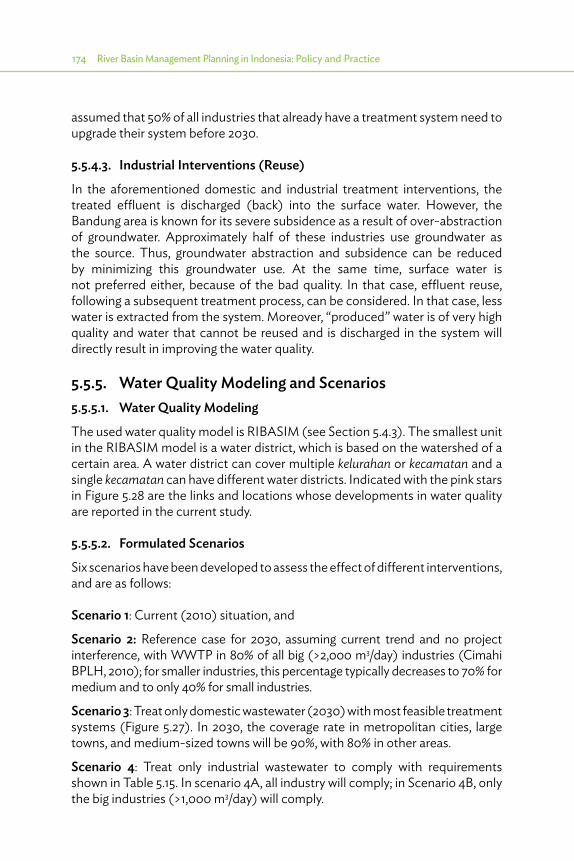
174 River Basin Management Planning in Indonesia: Policy and Practice
assumed that 50% of all industries that already have a treatment system need to upgrade their system before 2030.
5.5.4.3. Industrial Interventions (Reuse)
In the aforementioned domestic and industrial treatment interventions, the treated effluent is discharged (back) into the surface water. However, the Bandung area is known for its severe subsidence as a result of over-abstraction of groundwater. Approximately half of these industries use groundwater as the source. Thus, groundwater abstraction and subsidence can be reduced by minimizing this groundwater use. At the same time, surface water is not preferred either, because of the bad quality. In that case, effluent reuse, following a subsequent treatment process, can be considered. In that case, less water is extracted from the system. Moreover, “produced” water is of very high quality and water that cannot be reused and is discharged in the system will directly result in improving the water quality.
5.5.5. Water Quality Modeling and Scenarios 5.5.5.1. Water Quality Modeling
The used water quality model is RIBASIM (see Section 5.4.3). The smallest unit in the RIBASIM model is a water district, which is based on the watershed of a certain area. A water district can cover multiple kelurahan or kecamatan and a single kecamatan can have different water districts. Indicated with the pink stars in Figure 5.28 are the links and locations whose developments in water quality are reported in the current study.
5.5.5.2. Formulated Scenarios
Six scenarios have been developed to assess the effect of different interventions, and are as follows:
Scenario 1: Current (2010) situation, and
Scenario 2: Reference case for 2030, assuming current trend and no project interference, with WWTP in 80% of all big (>2,000 m3/day) industries (Cimahi BPLH, 2010); for smaller industries, this percentage typically decreases to 70% for medium and to only 40% for small industries.
Scenario 3: Treat only domestic wastewater (2030) with most feasible treatment systems (Figure 5.27). In 2030, the coverage rate in metropolitan cities, large towns, and medium-sized towns will be 90%, with 80% in other areas.
Scenario 4: Treat only industrial wastewater to comply with requirements shown in Table 5.15. In scenario 4A, all industry will comply; in Scenario 4B, only the big industries (>1,000 m3/day) will comply.
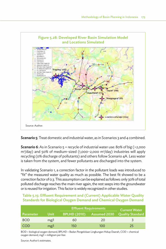
Methodology of Basin Planning in Indonesia 175
Figure 5.28: Developed River Basin Simulation Model and Locations Simulated
Source: Author.
Scenario 5: Treat domestic and industrial water, as in Scenarios 3 and 4 combined.
Scenario 6: As in Scenario 5 + recycle of industrial water use: 80% of big (>2,000 m3/day) and 50% of medium-sized (1,000–2,000 m3/day) industries will apply recycling (0% discharge of pollutants) and others follow Scenario 4A. Less water is taken from the system, and fewer pollutants are discharged into the system.
In validating Scenario 1, a correction factor in the pollutant loads was introduced to “fit” the measured water quality as much as possible. The best fit showed to be a correction factor of 0.3. This assumption can be explained as follows: only 30% of total polluted discharge reaches the main river again, the rest seeps into the groundwater or is reused for irrigation. This factor is widely recognized in other studies.
Table 5.15: Effluent Requirement and (Current) Applicable Water Quality Standards for Biological Oxygen Demand and Chemical Oxygen Demand
Parameter UnitEffluent Requirements Current Water
Quality StandardBPLHD (2010) Assumed 2030BOD mg/l 60 20 3COD mg/l 150 100 25
BOD = biological oxygen demand, BPLHD = Badan Pengelolaan Lingkungan Hidup Daerah, COD = chemical oxygen demand, mg/l = milligram per liter.
Source: Author’s estimates.

176 River Basin Management Planning in Indonesia: Policy and Practice
5.5.6. Benefit Estimation 5.5.6.1. Benefits Included
Table 5.16 shows which benefits were monetized, and which were described or quantified.
Table 5.16: Benefits of Improved Sanitation and Wastewater Management
Benefit Monetized Described or QuantifiedScenario 5Health Averted fecal–oral disease from
improved on-site sanitation and wastewater management
Reduced cases of food poisoning from consumption of fish infected by algal blooms or heavy metal
Averted health impacts due to less exposure during flooding events
Water Reduced water treatment costs to households and industries
Increased business investment due to availability of cheap, clean water
Improved fish yields from farming in downstream lakes
Reduced frequency and costs of floods after preventing further subsidence from excess groundwater extractiona
Environment Reduced frequency of river and reservoir dredging due to sludge extraction before wastewater release
Improved quality of life for riverside communitiesConservation: preserved biodiversity
Rise in land prices due to improved aesthetics of riverside and lakeside real estate
Tourism opportunities due to improved aesthetics of riverside and lakeside locations
Scenario 6Reuse Compost reuse from sludge and
organic municipal solid wasteBiogas generation from wastewater and organic municipal solid wasteRecycling of municipal solid waste (plastics, papers)Effluent reuse for industriesAverted maintenance costs of hydroelectric facilities becoming clogged with solid waste
a The assumption is that surface water can be sourced more easily and cheaply for municipal and industrial uses, thereby reducing the reliance on groundwater.
Source: Author’s estimates.

Methodology of Basin Planning in Indonesia 177
5.5.6.2. Resource Reuse Estimation Methodology
The costs of wastewater reuse are estimated in Scenario 6, and hence this section describes how the benefits were estimated. There are various potential markets in products of sanitation and wastewater. These include sludge for fertilizer, biogas for energy, and recovered water for productive uses. In addition, by recovering these resources, the costs of safe disposal of the original waste products are averted. Table 5.17 shows the parameters used.
Table 5.17: Parameters of Data Sources to Estimate Reuse Values in Scenario 6a
Resource Source Amount Produced Source of ValueCompost (from sludge) and organic solid waste
On-site and community-based wastewater options, centralized wastewater options, and organic solid waste management
•� Compost production from sludge from on-site and community-based sludge management systems (IPLT)
•� Wastewater volume × sludge per cubic meter of wastewater based on yield for anaerobic centralized options
•� Compost production from organic solid waste, assuming 60% as organic waste present (Meeting Indonesia’s Solid Waste Challenge, Jeroen Kool et al. in Prakarasa [2011])
Compost value based on nutrient content (Rp400 per kg)
Biogas Centralized sewerage plus organic solid waste
Wastewater volume × energy per cubic meter of wastewater; organic solid waste digestion
Energy value (Rp975 per kWh)
Recoverable solid waste products
Increased recycling rate of plastic and paper
Amount produced per household per year × number of households × % of waste recycled
Current market price for recycled plastic and paper (Rp2,000/kg)a
Recovered water
Industrial wastewater treated
Water recovery per cubic meter of wastewater × total wastewater produced × percentage of industries practicing wastewater recovery
Cost of groundwater extraction (Rp600/m3)
IPLT= Instalasi Pengolahan Air Limbah Terpadu.
Note: “×” indicates “multiplication.”a In September 2012, a mission to Banjarmasin was conducted, which showed the following prices for recovered
waste products: plastic bottle = Rp2,400/kg; white plastic bottle = Rp3,400/kg; other plastics = Rp1,800/kg; aqua bottles = Rp4,000/kg; cardboard = Rp1,100/kg; thick paper = Rp500/kg; glass bottles = Rp400/kg.
Source: 6 Cis Final Report (2013).

178 River Basin Management Planning in Indonesia: Policy and Practice
In addition, by reducing the solid waste disposal in water resources, the expensive damage and management of solid waste in hydropower installations are reduced. In addition, application of 3R (reduce, reuse, recycle) prevents waste from being landfilled, which results in averted landfill costs.
5.5.7. Conclusion Improvement of water quality to mandatory standards is feasible. This requires interventions on both domestic and municipal levels (by increasing access to improved basic sanitation and sewerage or wastewater management) as well as addressing industrial pollution. Implementation requires systematic planning, with long-term actions on multiple fronts comprising establishment and improvement of institutions; allocation of adequate funds; and the construction, operation, and maintenance of sanitation facilities to isolate and/or treat the wastewater. The estimated costs and benefits for treating both domestic and industrial wastewater, including resource recycling and reuse, are presented in a tabular form.
These values pertain to 2030 after the required interventions have been scaled up, presented in the 2010 prices. The annualized benefits outweigh the annualized costs by a factor of 2.3. The major share of costs is for improving access to domestic sanitation and wastewater treatment (Rp13.7 trillion, or $1.5 billion) compared with industrial interventions (Rp1.6 trillion, or $172 million) over a 20-year period. Hence, the sanitation interventions not only improve the water quality but are also economically attractive. Moreover, some benefits have been excluded so that the ratio of benefits to costs could be significantly greater.
Table 5.18: Overview of Benefits/Cost for Waste Water Treatment in Upper Citarum Basin
Variable
Domestic Wastewater Treatment and Industrial Wastewater
Treatment and ReuseRupiah billion $ million
Investment cost (over 20 years) 15,794 1,670Annualized costs, including recurrent costs 1,164 129Annual benefits 2,631 280Cost-benefit ratio 2.3 2.3
Source: 6 Cis Final Report (2013).
Values refer to when interventions are scaled up in the year 2030, presented in 2010 prices.
Methodology of Basin Planning in Indonesia 179
The road map required to bring about improved water quality in the Upper Citarum River comprises several steps, starting with the simple ones, and leaving the more complicated ones for the future. The recommended approach starts with setting up of local organizations to manage sanitation development, including implementation of relatively simple interventions such as promotion of and incentives for effective septic tanks, community-based wastewater treatment systems, improved solid waste collection, transport, and disposal. It is also recommended to address pollution caused by larger industries at an early stage.
However, reducing industrial pollution requires both more effective enforcement of present regulations and improvements to the legal framework. More complicated and larger infrastructure, such as off-site wastewater treatment systems, solid waste infrastructure (sanitary landfills), and resource recovery facilities, require more time to be successfully implemented, and are recommended for the medium to the long term. The introduction and support of resource recovery through government and private sector actions is highly recommended because of its economic attractiveness and the preservation of scarce resources. It is therefore recommended to start planning for resource recovery infrastructure at an early stage.
5.6. Forecasting
5.6.1. Scenarios (Including Climate Change Scenarios) Scenarios are alternative metaphors of how the future might unfold and are nowadays widely used in assessing the medium- and long-term consequences of ongoing change. They are not predictions to which likelihood can be attached. Rather, they describe plausible future as a function of changes in major (external) driving forces (i.e., the main determinants of change in a scenario), such as population growth, economic development, or technological change.
In water resources management (WRM), scenarios are typically related to developments outside the direct influence of water managers. Yet scenarios generally have an important influence on the future requirements to water management. An example is population growth. The expected increase in the population will lead to higher water and food requirements, which in turn will present higher irrigation water requirements. Also, population growth could lead to increased urbanization, which in turn may reduce land availability for agriculture.
It is noted that in fields other than WRM, the term scenario is sometimes used to describe how the future might unfold, including the actions by water managers such as, for example, the implementation of water supply projects.

180 River Basin Management Planning in Indonesia: Policy and Practice
This difference in definition might easily lead to confusion, and it is advisable to avoid that by clearly explaining the term scenario at the outset of any project.
In an integrated approach to Integrated Water Resources Management (IWRM) and spatial planning, scenarios need to be considered for the following external factors:
•� population growth,•� economic growth,•� climate change, and•� governance.
The time horizon considered is primarily between 2010 and 2030, with an additional period for more long-term assessment of some aspects for 2050.
We linked our scenarios to the comprehensive global narratives or storylines presented in the Special Report on Emission Scenarios (SRES) of the Intergovernmental Panel on Climate Change.34 The SRES storylines are a comprehensive set of narratives that define the local, regional, and global socioeconomic driving forces of environmental change (e.g., demography, economy, technology, energy, and agriculture).
5.6.1.1. Population Scenarios
We need a growth scenario of the total population of Java as input for the Java Spatial Model (JSM), as explained in Section 5.4.5. This growth is distributed each year among the kabupaten and desas in the JSM. For specific aspects, further linked scenario development is needed, such as, for example, the household size (number of people per household) and the household urban area developments.
According to the 2000 population census, the population of Java was 121.3 million, whereas it was 136.6 million according to the 2010 population census. For population projections, there are two sources: (i) the National Development Planning Agency (BAPPENAS; 2004) projection from 2000–2025 and (ii) the more recent Central Statistics Agency (BPS) projection for 2005–2015. The total population according to both projections and the census is shown in Figure 5.29. As can be seen in that figure, both projections underestimate the actual 2010 numbers from the census.
Obviously, the actual growth rate has been higher than was foreseen in the two projections. For IWRM and spatial planning purposes, we need long-term growth rates up to 2050. Therefore, we based the growth rate for Java as input to the
34 Nakićenović, N. and R. Swart (eds.), 2000: Emissions Scenarios. Special Report of Working Group III of the Intergovernmental Panel on Climate Change. Cambridge, UK: Cambridge University Press x+599 pp.
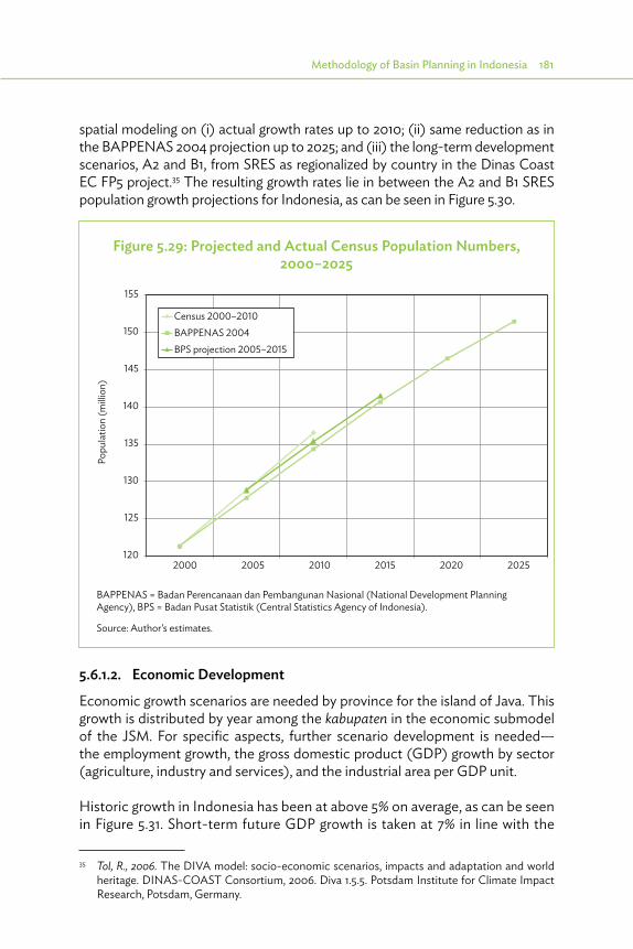
Methodology of Basin Planning in Indonesia 181
spatial modeling on (i) actual growth rates up to 2010; (ii) same reduction as in the BAPPENAS 2004 projection up to 2025; and (iii) the long-term development scenarios, A2 and B1, from SRES as regionalized by country in the Dinas Coast EC FP5 project.35 The resulting growth rates lie in between the A2 and B1 SRES population growth projections for Indonesia, as can be seen in Figure 5.30.
5.6.1.2. Economic Development
Economic growth scenarios are needed by province for the island of Java. This growth is distributed by year among the kabupaten in the economic submodel of the JSM. For specific aspects, further scenario development is needed—the employment growth, the gross domestic product (GDP) growth by sector (agriculture, industry and services), and the industrial area per GDP unit.
Historic growth in Indonesia has been at above 5% on average, as can be seen in Figure 5.31. Short-term future GDP growth is taken at 7% in line with the
35 Tol, R., 2006. The DIVA model: socio-economic scenarios, impacts and adaptation and world heritage. DINAS-COAST Consortium, 2006. Diva 1.5.5. Potsdam Institute for Climate Impact Research, Potsdam, Germany.
Figure 5.29: Projected and Actual Census Population Numbers, 2000–2025
120
125
130
135
140
145
150
155
2000 2005 2010 2015 2020 2025
Census 2000–2010BAPPENAS 2004BPS projection 2005–2015
Popu
latio
n (m
illio
n)
BAPPENAS = Badan Perencanaan dan Pembangunan Nasional (National Development Planning Agency), BPS = Badan Pusat Statistik (Central Statistics Agency of Indonesia).
Source: Author’s estimates.
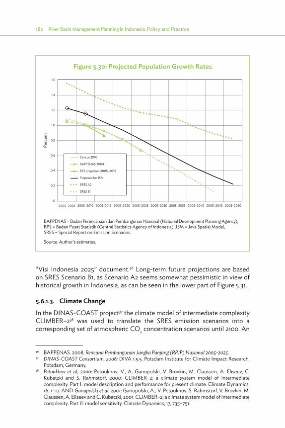
182 River Basin Management Planning in Indonesia: Policy and Practice
“Visi Indonesia 2025” document.36 Long-term future projections are based on SRES Scenario B1, as Scenario A2 seems somewhat pessimistic in view of historical growth in Indonesia, as can be seen in the lower part of Figure 5.31.
5.6.1.3. Climate Change
In the DINAS-COAST project37 the climate model of intermediate complexity CLIMBER–238 was used to translate the SRES emission scenarios into a corresponding set of atmospheric CO2 concentration scenarios until 2100. An
36 BAPPENAS. 2008. Rencana Pembangunan Jangka Panjang (RPJP) Nasional 2005-2025.37 DINAS-COAST Consortium, 2006: DIVA 1.5.5. Potsdam Institute for Climate Impact Research,
Potsdam, Germany.38 Petoukhov et al, 2000: Petoukhov, V., A. Ganopolski, V. Brovkin, M. Claussen, A. Eliseev, C.
Kubatzki and S. Rahmstorf, 2000: CLIMBER–2: a climate system model of intermediate complexity. Part I: model description and performance for present climate. Climate Dynamics, 16, 1–17. AND Ganopolski et al, 2001: Ganopolski, A., V. Petoukhov, S. Rahmstorf, V. Brovkin, M. Claussen, A. Eliseev and C. Kubatzki, 2001: CLIMBER–2: a climate system model of intermediate complexity. Part II: model sensitivity. Climate Dynamics, 17, 735–751.
Figure 5.30: Projected Population Growth Rates
0
0.2
0.4
0.6
0.8
1.0
1.2
1.4
1.6
2000–2005 2005–2010 2005–2015 2005–2020 2005–2025 2005–2030 2005–2035 2005–2040 2005–2045 2005–2050
Census 2010
Perc
ent
BAPPENAS 2004
BPS projection 2005–2015
Proposed for JSM
SRES A2
SRES B1
BAPPENAS = Badan Perencanaan dan Pembangunan Nasional (National Development Planning Agency), BPS = Badan Pusat Statistik (Central Statistics Agency of Indonesia), JSM = Java Spatial Model, SRES = Special Report on Emission Scenarios.
Source: Author’s estimates.

Methodology of Basin Planning in Indonesia 183
Figure 5.31: Historic and Projected Economic Growth Rates
2010–2005 2015–2020 2020–2025 2025–2030 2030–2035 2035–2040 2040–2045 2045–2050
8
7
6
5
4
3
2
1
0
GD
P gr
owth
(%)
GDP growth % A2 GDP growth % JSM 2.1 GDP growth % B1
–15
–10
–5
0
5
10
15
1960 1965 1970 1975 1980 1985 1990 1995 2000 2005 2010
GDP growth % Indonesia
World Bank
50 years Merdeka, BPS
BPS = Badan Pusat Statistik (Central Statistics Agency of Indonesia), GDP= Gross Domestic Product, JSM = Java Spatial model.
Sources: http://data.worldbank.org/indicator/NY.GDP.MKTP.KD.ZG/countries/latest?display=default;1960 –1994 data processed from BPS. 1995, Statistik Dalam 50 Tahun Indonesia Merdeka [Statistics in 50 Years Independent Indonesia]. Jakarta; 1995–2010 data from Statistics Indonesia BPS. 2010, National Income of Indonesia.

184 River Basin Management Planning in Indonesia: Policy and Practice
updated version of CLIMBER–2 was then used to produce a set of internally consistent scenarios of sea level rise and temperature changes with respect to 1990. The aforementioned global results were also regionalized in five by five degrees grid cells using the CLIMBER-2 model. The regionalized results for the range of expected changes (since 1990) in Indonesia are:
Average temperature change 2030: 0.336–1.032 (°C)Average temperature change 2050: 0.520–1.848 (°C)Average precipitation change 2030: 0.117–0.394 (mm/day)Average precipitation change 2050: 0.181–0.726 (mm/day)Sea-level rise 2030: 0.052–0.203 (m)Sea-level rise 2050: 0.092–0.367 (m)
For precipitation change, it is noted that different climate models have different signs for their results in Indonesia. Note that actual sea-level rise must be calculated by adding subsidence to the sea-level rise due to climate change; for the Jakarta metropolitan region, this leads to a much higher figure.
5.6.1.4. Governance
Governance is added to the parameters that define scenarios particularly for the governance aspects that WRM depends upon. Of course, the water managers themselves contribute to governance, but, to a large extent, they depend on governance aspects at the higher levels in government and in society as a whole. An example will clarify this. If, for example, the central government succeeds in efforts to considerably strengthen the enforcement of existing laws and regulations, the reduction of irrigated agricultural land due to urbanization in Java could be minimized.
If, on the contrary, the central government continues the current situation of relatively weak law enforcement, the loss of irrigated land due to urbanization could be considerable. It is obvious that the scenario of weak law enforcement will lead to a very different future situation for water managers when compared with the scenario of strong enforcement. This example illustrates why scenario assumptions regarding governance are of importance to water management planning. In the 6 Cis project, two scenarios were maintained regarding governance: a scenario with “business as usual,” and an alternative scenario that assumes a maximum governance effort.
5.6.2. StrategiesStrategies are not forecasts but envisaged developments based on comprehensive combinations of measures, which together lead to reaching
Methodology of Basin Planning in Indonesia 185
the objective of WRM that is agreed upon earlier in the planning process. Usually, different pathways are defined, based on specific directions, to reach the common objective. As such, the Jabotabek Water Resources Management Study (JWRMS) defined five strategies to reach the common objective of water supply to Jakarta:
(i) minimum investment strategy,(ii) balanced supply strategy (supply from east and west side),(iii) Karian only for Banten area strategy,(iv) safe drinking water strategy, and(v) multiobjective strategy.
5.6.3. Consistencies (Java Spatial Model)The main objective of the strategic spatial planning input to Integrated Water Resources Management (IWRM) is to provide the IWRM planning process with internally consistent quantitative spatial planning outputs. For basin planning in Java, the JSM (described in Section 5.4.5) can be used. Projections for population growth in the whole of Java are straightforward (and provided by BPS), but projections of growth in each desa and the related land-use changes are more complicated. The JSM is used to provide spatial projections of population and associated land-use changes for all desa in Java, based on population projection for Java and economic growth projection by province.
The growth of Java as a whole is more or less constant, mostly related to population growth and limited migration. But the growth in the various regions of Java shows much wider variations, because this has a much greater proportion of migration. The JSM can give more consistent forecasts of this growth, as it analyzes the various attributes related to attractiveness of the regions, triggering the migration, and relates the emigration from one district to the immigration into another district where the balance should be within the limits of the aggregated growth over the whole island of Java. The regions frequently set nonrealistic scenarios for population growth (or outflows), and more consistency is possible when addressed by using the JSM analysis.

6 Experience in River Basin Planning in Indonesia
6.1. Introduction
The common critique mentioned in comments on Basin Water Resources Management Planning (BWRMP) in Indonesia is that it has not delivered much in terms of realized facilities. Many
plans have been prepared, but beyond delivering the report, they have not been implemented. This is partly true, and inherent in the ambitious targets. However, plans were prepared for envisaged developments with 20-year time horizons, with many uncertainties, especially the full commitment of all stakeholders involved. More importantly, nothing has changed in terms of general policy setting (water security is not yet one of the prominent national goals); even now, national budgets are prepared and financial incentives are set based on a more or less equal distribution over the sector, without considering rationally selected priorities, or even sometimes short-term politically biased priorities. Implementation does not depend only on the quality of the plans, but it depends even more on the framework within which the plan has to be implemented. Changing national or provincial government every 5 years already has a significant impact.
The challenges of Integrated Water Resources Management (IWRM) (conservation, utilization, and water-related disasters) are closely interlinked, and policies or other solutions must take this into account. But it is almost impossible for most institutions to take an integrated view of such issues, given the complexity of the matter and the conflicting interests of a cross-sectoral approach. It takes brave political will to take bold action.
Meanwhile, a number of successful Master Plans have shown the merits of an integrated approach. They resulted in shared views on the present situation, the preferred future situation, and the steps to be taken to realize that future situation. With proper focus on common interests and clear direction regarding implementation, the steps can deliver clear results.
Moreover, they contributed to an improved environment for IWRM planning. The legal framework (Forestry Law 41/1999, Water Law 7/2004, Spatial Planning Law 26/2006, Agricultural Law 41/2009, and Environmental Law 32/2009, and related government regulations and guidelines) has been adapted, and although planning and implementation of the different aspects

Experience in River Basin Planning in Indonesia 187
of IWRM are still sector regulated, it shows where integration with other sectors is needed. Institutionally, the establishment of coordination platforms at the national, provincial, and basin levels contributed to a more integrated and service-oriented approach, although overlaps with other platforms, such as the Forestry Forum, have to be addressed. Section 6.2 describes some of these successful Master Plans.
Presently, basin planning is accorded lower priority than the implementation of projects. This is understandable given the much higher budgets involved in the implementation of projects. However, it does not acknowledge that present developments should fit in a larger framework, stimulating developments contributing to the larger framework and avoiding developments that later have to be retracted because they are not in line with that framework. Therefore, the overall organizational system should give higher incentives for the institution preparing an adequate plan for a larger framework, in close consultation with all other relevant sectors and for implementing that plan in cooperation with those other sectors.
6.2. Achievements in Various Basins
6.2.1. Brantas BasinThe Brantas basin is a national strategic basin in East Java, comprising two major cities, Malang and Surabaya. Three consecutive plans that have been prepared for the Brantas basin focused on irrigation development (1975), on flood management (1985), and on environmental aspects and conservation (1995). These plans assisted in developing a clear direction for the investments and in achieving a significant part of the goals (construction of dams and reservoirs as well as flood-mitigating facilities).
Implementation clearly benefited from the fact that the plan was prepared by the USER to be implemented by a separate PROVIDER. The USER was the entity operating the major facilities in the river, which is now PJT 1 (Water Management Company I). They formulated the framework of activities (as a Terms of Reference) to be implemented and financed through the PROVIDER, the national Brantas Project Organization, whose role has now been taken over by Basin Water Resources Management Centers [B(B)WS] Brantas. These separate responsibilities highly contributed to a clear role distribution, avoiding overlapping interests and ensuring a transparent process regarding quality assurance, with PJT 1 acting as user/client and Brantas Project as provider.

188 River Basin Management Planning in Indonesia: Policy and Practice
The Pola for Brantas was prepared in 2006 by B(B)WS and endorsed by the Minister of Public Works in 2010. Presently, B(B)WS is finalizing the procedures for endorsing the Rencana, as formulated in 2011/2012. The task of allocating roles to the user and the provider is now taken over by the Basin Council (TKPSDA) as the user, with PJT 1 as one of the most active members, and the B(B)WS Brantas as the provider.
6.2.2. Bengawan Solo BasinThe Bengawan Solo Basin is located in Central and East Java and comprises Surakarta as the major city, with many smaller cities in its course. The basin has also been the focus of various Master Plans, which finally led to the construction of the Wonogiri Dam, completed in 1990. Because it is spread across two provinces, planning and stakeholder participation is somewhat more complicated than elsewhere.
However, it has a very active TKPSDA, chaired alternatively every year, either by the head of Regional Development Planning Agency (BAPPEDA, East Java) or the head of BAPPEDA (Central Java). During the initial formulation of the Pola and the Rencana, the TKPSDA is adequately supported by the secretariat of the TKPSDA (headed by staff from B(B)WS Bengawan Solo), which was mainly due to active support by the head of the B(B)WS and the first two chairmen of the TKPSDA. This TKPSDA is still a shining example for many other TKPSDAs, and as mentioned in Section 6.3, it was also used as an inspiration and example for TKPSDA 6 Cis.
The Pola was formulated in 2007 by the B(B)WS Bengawan Solo and endorsed by the Minister of Public Works in 2010. The Rencana was formulated in 2011 and 2012, and is scheduled for endorsement in 2014. During formulation, the TKPSDA played an active role as user, which contributed to the transparent process of quality assurance. Four reservoirs are under construction in this river basin territory or Wilayah Sungai (WS), and this may have relations with the timely processing of the Pola and Rencana.
6.2.3. West Java and Citarum BasinThe area comprises three provinces: Jakarta, West Java, and Banten, and many WS. WS Citarum is the largest WS, with Bandung located in its upper watershed. WS Citarum has three major dams and reservoirs: Juanda (Jatiluhur) (1968); and a multipurpose project Saguling (1978) and Cirata (1984), which are mainly for hydropower generation. Juanda is the most important source of surface water supply to Jakarta, bringing 16 m3/sec to Jakarta through the West Tarum Canal, which was originally an irrigation canal.

Experience in River Basin Planning in Indonesia 189
For Western Java, several comprehensive water resources management (WRM) plans have been prepared. The early ones mainly focused on water utilization, with some attention to conservation. Flood management has been addressed in separate studies by the Japan International Cooperation Agency (JICA; 1991–1995) for Bandung and JICA (1996), Netherlands Engineering Consultants (1996 and 2002), and several Dutch companies (Jakarta Flood Management Project 2007–2009) for Jakarta.
A first attempt for an integrated water resources plan was made under project Cisadane-Cimanuk Integrated Water Resources Development (BTA155) (1985–1991). The plan provided a comprehensive overview of the available and required water resources, identified bottlenecks (shortages, threats of erosion, sedimentation, and inferior water quality (present and future), and possibilities of preventing these bottlenecks from growing worse or mitigating them. The plan identified building of the Jatigede Dam and the Karian Dam as the two outstanding projects for achieving sufficient water resources, and indeed now, 25 years later, Jatigede is almost completed and construction of Karian dam was started in 2015.
Two similar studies, that of the Cibeet River (1980–1985) and the Jabotabek Water Resources Management Study (JWRMS) (1991–1995), concentrated on water supply to Jakarta. The first study addressed the quantitative and qualitative aspects of water supply to Jakarta. The quality problems could be quickly improved by locating the intakes farther outside the city. The quantity problems necessitated construction of extra canals from the Juanda (Jatiluhur) reservoir to Jakarta (Tarum Jaya parallel to the Kali Malang canal or Canal 2 higher in the mountains). The second study confirmed the conclusions of BTA155 and CIBEET, but also stressed the importance of limiting overexploitation of groundwater in the north of Jakarta, leading to local land subsidence of 10 cm/year.
In 1996, the first Basin Water Resources Plan (BWRP) was prepared under the Java Irrigation and Water Management Project (JIWMP) by Basin Water Resources Plan for Citarum.39 This plan concentrated mainly on water utilization, with only a mention of the flood problems, referring to earlier studies. Shortly after that, the Government of West Java, assisted by the Government of South Australia (Adelaide), prepared the Pola Induk, a more IWRM plan, which was mainly based on the results of BTA155 and BWRP, but added institutional aspects of implementing the plan and operating the facilities.
In 1998–2000, the end of the New Order government, and reform and decentralization changed the situation to a great extent. As a result, Banten
39 Java Irrigation and Water Management Project (JIWMP), Rijkswaterstaat, et al. 1996.
190 River Basin Management Planning in Indonesia: Policy and Practice
province was separated from West Java province, and much more emphasis was given to public consultation and participation.
From 2005 to 2009, the Asian Development Bank (ADB) implemented the Road Map for Citarum study, in preparation for a new loan. This was mainly done through B(B)WS Citarum. The activities built further on the results of the earlier studies but included a big effort to include all stakeholders. As mentioned in Section 4.5, this resulted in a common view of the present situation in the Citarum basin, the preferred future situation, steps to be taken to realize that future situation, and a multitranche financing facility for the Integrated Citarum WRM Investment Program. Initially, this framework program was supported by the new loan from ADB, but the intention was to gradually involve other donors in funding specific parts of this framework project. For example, the Government of the Netherlands assisted in the “Institutional strengthening of IWRM in the 6 Cis WS.”
Under this 6 Cis component, the Pola and Rencana for Citarum have been prepared from 2009 to 2012, and it also included the establishment of TKPSDA, as discussed in Section 6.3. The formulation was done by B(B)WS assisted by consultants, with four public consultation meetings (PCMs) (two for Pola and two for Rencana) in Bandung, and several discussions with the TKPSDA. These plans were based on Water Law 7/2004 and Government Regulation (PP) 42/2008 on WRM, as well as the PerMen 22/2009 for the formulation of Pola. It built further on the results of the Road Map for Citarum and all earlier studies concerning conservation, utilization, and flood management, as well as data and information and public participation. It also covered spatial planning and institutional aspects. Legalization of this Pola and Rencana takes a long time, because the WS 6 Cis was split into three WS (one of them being WS Citarum). The Pola was approved by TKPSDA in 2013 and endorsed by the Minister of PU in April 2014. The Rencana will be discussed with the TKPSDA in 2014.
6.2.4. Central Java and Jratunseluna BasinCentral Java has taken up an active role in formulating BWRPs. In 1998, the Dinas PSDA was assisted by Rijkswaterstaat in formulating basin plans under the JIWMP, assisted by a loan from the World Bank. Also, for the formulation of basin plans, Central Java set up a permanent planning unit formed by their own staff, comprising a team leader, a hydrologist, a water resources planner, and an economist, who were trained by consultants from Rijkswaterstaat in the specific tasks of this planning. Care was taken to ensure that vacancies in the planning unit were filled in time with adequate knowledge transfer from the outgoing

Experience in River Basin Planning in Indonesia 191
official to the successor. As such, plans were prepared for Jratunseluna, Progo-Bogowonto (covering interprovincial Progo River), and Pemali Comal for 1998–2004.
WS Jratunseluna is a national strategic basin, located in Central Java, comprising the Jragung, Tuntang, Serang, Lusi, and Juana river basins. Semarang is located in the Western Jragung basin. The Tuntang River has a natural lake, Rawa Pening. The lower part of the WS is mainly used for agricultural purposes, with some major cities such as Kudus and Demak in its course. Floods are a regular phenomenon in this area.
Several Master Plans have been formulated for the Jratunseluna Basin, which led to the construction of the Kedung Ombo reservoir (completed in 1987) and several flood management facilities. In 1999–2000, Rijkswaterstaat assisted in the formulation of the Jratunseluna Basin Water Resources Plan, mainly incorporating a comprehensive view on water utilization and conservation, but not on flood management. Rijkswaterstaat also organized two PCMs for the formulation of BWRPs with the assistance of the Canadian International Development Agency in North Sulawesi.
In 2002–2004, the plan was updated by Rijkswaterstaat under the Indonesia Water Resources and Irrigation Reform Implementation Project. The aim was to include a strategic management plan (something such as the Pola), addressing conservation and utilization, as well as the institutional framework to realize the plan. As such, this was referred to as Basin Water Resources Management Plan.
The Pola for Jratunseluna was formulated in 2006 with Indonesian funds and endorsed by the Minister of PU in 2010. The Rencana was formulated in 2010 by B(B)WS Pemali Juana, with assistance from DHV under the Water Resources and Irrigation Sector Management Program (WISMP) I loan from the World Bank, and included two PCMs. However, TKPSDA had not yet been active by that time. Therefore, the process was continued in 2011 for completion and discussion with TKPSDA, but it has not yet been proposed for endorsement by the Minister of PU.
6.2.5. Progo Opak Serang BasinWS Progo Opak Serang (POS) is located in two provinces, Central Java and Yogyakarta, and comprises the major cities of Magelang and Yogyakarta. The Progo River flows from Central Java to Yogyakarta, and is the main water source for both Magelang and Yogyakarta, as well as for large irrigation schemes. East

192 River Basin Management Planning in Indonesia: Policy and Practice
of Yogyakarta is a karstic limestone area, where water from the subterranean rivers is the major source. The WS has one small reservoir, Waduk Sermo, in the Serang basin.
The Pola for POS was formulated in 2005 with Indonesian funds and was endorsed by the Minister of PU in 2010. The Rencana was formulated in 2010, by B(B)WS Serayu–Serang, with assistance from DHV under the WISMP I loan from the World Bank, and included two PCMs. However, TKPSDA had not yet been active by that time. Therefore, the process was continued in 2011 for completion and discussion with TKPSDA, but it has not yet been proposed for endorsement by the Minister of PU.
6.2.6. Pemali ComalWS Pemali Comal is located in Central Java and has a long history of WRM development. It was started in the colonial period with improved development methods for irrigation design and operation for the Pemali and Comal irrigation schemes and construction of the Cacaban reservoir in the Cacaban river located between the Pemali and Comal rivers. Early basin plans were prepared by the planning unit, as mentioned in Section 6.2.3. A WRM center at the provincial level, Pemali Comal was established by the Dinas PSDA of Central Java for WRM and operation of the facilities in 2000.
According to PerMen 11A/2006, Pemali Comal was a national strategic basin and according to PerMen 26/2006, it was operated by B(B)WS Pemali Juana. This B(B)WS immediately started formulation of the Pola in 2006, but this had to be adjusted according to the PerMen 22/2009 (guideline for preparation of the Pola). The Balai PSDA Pemali Comal under the Dinas SDA continued the operation of the facilities, according to the memorandum of understanding agreed with B(B)WS Pemali Juana.
In 2012, the status of Pemali Comal changed according to KepPres 12/2012, and it again became a WS under the responsibility of the province. Also, the TKPSDA (established based on a letter from the Minister of PU) had to be changed and reestablished based on a letter from the governor, which was arranged in 2013. In December 2013, the Pola for Pemali Comal was agreed with the new TKPSDA and was recently endorsed by the governor in 2014.
B(B)WS Pemali Juana is still involved in WS Pemali Comal. Officially, this only considers operation and maintenance (O&M) of the irrigation schemes larger than 3,000 hectares in the WS. But some additional assistance is also given for other facilities, since the budget of the B(B)WS is significantly higher than

Experience in River Basin Planning in Indonesia 193
the funds available from the province for WS Pemali Comal. It is unclear how sustainable this involvement is.
6.3. Experience in Coordination with Tim Koordinasi Pengelolaan Sumber Daya Air
6.3.1. Establishing Water CouncilsCoordination in WRM is mandated by Water Law No. 7/2004. Article 85 specifies that WRM should be carried out through coordination by integrating the interests of various sectors, regions, and stakeholders to maintain sustainable water resources functions and benefits. This should be done through establishment of national and provincial councils (Dewan SDA) and, possibly, even at the basin level (now known as TKPSDA).
Presidential Decree KePres 12/2008 arranges for establishment of national and provincial councils. Ministerial regulations provide further guidance on organization (KepMen PU 4/2008) and support (the secretariat, KepMen 11/2008). The national water council was established in 2009 and started functioning in 2010. A provincial water council has been established in 28 of the 33 provinces, as shown in Table 6.1. Five provinces had no provincial water
Public consultation for Pola in Citarum river basin, 1 November 2012. Following the Presidential Decree No. 12/2012 concerning the determination of river basin territories (RBTs), the 6 Cis RBT has been divided into three new RBTs.
Source: 6 Cis Consultants’ Team.
194 River Basin Management Planning in Indonesia: Policy and Practice
council yet in May 2014: Bali, West Kalimantan, Maluku Utara, Papua and West Papua. Basin Councils (TKPSDA) have been established in 35 of the 131 basins, as shown in Table 6.2, while another 14 have been established but had to be altered because of changes in the administration (KepPres 12/2012 changed responsibility, or formation of new provinces). Most of the basins where basin councils have been formed are under central government control; in 73 basins, no progress has been reported about the formation of a basin council.
The remainder of this section illustrates the process of establishing and empowering the TKPSDA in the 6 Cis area. In this process, the experiences with the TKPSDA in Bengawan Solo were a good example.
Progress in establishment of provincial water councils and basin councils is presented in Tables 6.1 and 6.2.
6.3.2. Experience with the Tim Koordinasi Pengelolaan Sumber Daya Air in 6 Cis
The TKPSDA in 6 Cis river basin territory (RBT) was established in December 2010 and was legalized by Public Works’ Ministerial Decree No. 594/2010. According to Public Works Ministerial Regulation No. 11/2006, Cidanau-Ciujung-Cidurian-Ciliwung-Cisadane-Citarum (6 Cis) RBT was categorized as transprovincial boundary river territory, covering the provinces of Banten, DKI Jakarta, and West Java. However, unlike other rivers within this category, 6 Cis was very specific because it was operated by three B(B)WS: B(B)WS Cidanau-Ciujung-Cidurian, B(B)WS Ciliwung-Cisadane, and B(B)WS Citarum; and one state-owned enterprise, PJT 2.
The selection process of TKPSDA members was conducted by the selection team, composed of representatives from four government agencies at the provincial level and one from B(B)WS. A total of 96 TKPSDA members representing government and nongovernment organizations (NGOs) in equal numbers were then selected from central government, 3 provinces, and 28 districts and cities; the central government was represented by three B(B)WS, one Balai Pengelolaan Daerah Aliran Sungai (River Basin Management Agency under Ministry of Environment and Forestry), and PJT 2. Each provincial government was represented by five government agencies related to the water sector (BAPPEDA, Dinas Kehutanan, Dinas PSDA, Dinas Pertanian, and Badan Pengelola Lingkungan Hidup). While the district or city was represented by BAPPEDAs and/or water resources agencies, nongovernment members (NGOs, community groups, and business entities) came from institutions representing various water-related sectors, as required by Public Works

Experience in River Basin Planning in Indonesia 195
Table 6.1: Overview of Establishment of Dewan Sumber Daya Air
No. Province EstablishedMembers
(Government)Members
(Nongovernment)1 Nanggroe Aceh
Darussalam2009 14 13
2 Sumatera Utara 2010 14 133 Sumatera Barat 2009 15 134 Sumatera Selatan 2009 13 125 Bengkulu 16 136 Lampung 2011 14 147 Banten 2008 14 98 DKI Jakarta 2010 16 159 Jawa Barat 2010 19 1610 Jawa Tengah 2008 15 1411 DI Yogyakarta 2009 19 1612 Jawa Timur 2009 14 1413 Nusa Tenggara Barat 2009 16 1614 Nusa Tenggara Timur 2009 19 1715 Sulawesi Utara 2009 14 1616 Sulawesi Tengah 2009 13 1117 Sulawesi Barat 201018 Sulawesi Selatan 2009 21 2019 Kalimantan Timur 2009 18 1820 Kalimantan Barat 2010 14 1121 Maluku 2010 13 1322 Jambi 2011 14 1423 Riau 2011 18 1824 Gorontalo 2011 6 625 Kepulauan Riau 2011 11 1226 Kep. Bangka Belitung 201227 Kalimantan Selatan 201328 South East Sulawesi 2014
Source: Subdirectorate Kelembagaan in the Directorate General for Water Resources at Ministry of Public Works.
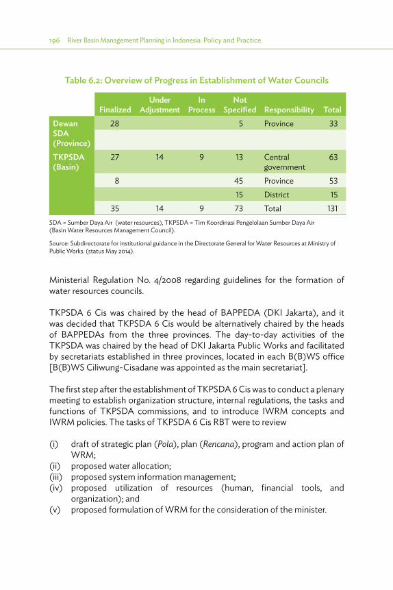
196 River Basin Management Planning in Indonesia: Policy and Practice
Ministerial Regulation No. 4/2008 regarding guidelines for the formation of water resources councils.
TKPSDA 6 Cis was chaired by the head of BAPPEDA (DKI Jakarta), and it was decided that TKPSDA 6 Cis would be alternatively chaired by the heads of BAPPEDAs from the three provinces. The day-to-day activities of the TKPSDA was chaired by the head of DKI Jakarta Public Works and facilitated by secretariats established in three provinces, located in each B(B)WS office [B(B)WS Ciliwung-Cisadane was appointed as the main secretariat].
The first step after the establishment of TKPSDA 6 Cis was to conduct a plenary meeting to establish organization structure, internal regulations, the tasks and functions of TKPSDA commissions, and to introduce IWRM concepts and IWRM policies. The tasks of TKPSDA 6 Cis RBT were to review
(i) draft of strategic plan (Pola), plan (Rencana), program and action plan of WRM;
(ii) proposed water allocation;(iii) proposed system information management;(iv) proposed utilization of resources (human, financial tools, and
organization); and(v) proposed formulation of WRM for the consideration of the minister.
Table 6.2: Overview of Progress in Establishment of Water Councils
FinalizedUnder
AdjustmentIn
ProcessNot
Specified Responsibility TotalDewan SDA (Province)
28 5 Province 33
TKPSDA(Basin)
27 14 9 13 Central government
63
8 45 Province 5315 District 15
35 14 9 73 Total 131SDA = Sumber Daya Air (water resources), TKPSDA = Tim Koordinasi Pengelolaan Sumber Daya Air (Basin Water Resources Management Council).
Source: Subdirectorate for institutional guidance in the Directorate General for Water Resources at Ministry of Public Works. (status May 2014).

Experience in River Basin Planning in Indonesia 197
Prior to the establishment of the TKPSDA, a draft IWRM strategic plan (Pola) in the 6 Cis (as part of the formulation process) was discussed in a PCM and was attended by some of the (then still potential) TKPSDA members. Therefore, when the Pola was reviewed by the TKPSDA, some of the TKPSDA members were already familiar with the Pola. However, it was not easy to arrive at a consensus since the TKPSDA 6 Cis comprised various stakeholders. Different perspectives emerged between government and nongovernment representatives as well as between various government agencies, depending on their tasks and functions, and between the various NGOs depending on their interests. The difficulty in reaching an agreement was mostly due to lack of attention from government agencies. Those who attended the meetings were often only the staff, rather than organization heads or managers who can make decisions.
Coordination for reaching an agreement on a draft plan not only means revising the plan based on the opinions of relevant stakeholders but also steering the changes in the direction of an optimal solution that can be supported by all major stakeholders. Coordination and its resulting changes need to be convincing for and as equitable as possible among stakeholders. Consensus will not be reached among stakeholders if the plan is biased toward specific stakeholder groups.
In the first plenary meeting, general problems were addressed, such as groundwater extraction in Jakarta, Jakarta taking water from the Citarum River and its related compensation, conflict between domestic water users and industries in the Bandung district, the important role of the community, linkage between the WRM plan and the spatial plan, and the need to set priorities. The plenary meeting also discussed a draft regulation on its own decision-making mechanism.
After this, for more focus on the review of Pola, TKPSDA members were divided into three commissions for conservation (chaired by the head of BAPPEDA Jawa Barat), water utilization (chaired by the head of B(B)WS Cidanau-Ciujung-Cidurian), and water destructive force (chaired by the head of B(B)WS Ciliwung-Cisadane). Each commission comprised various representatives from each province. The commission meetings and other plenary meetings were held several times, and finally these meetings resulted in the positive recommendation submitted to the Public Works Minister in December 2011.

198 River Basin Management Planning in Indonesia: Policy and Practice
However, in conjunction with the enactment of Presidential Decree No. 12/2012 concerning the determination of RBTs (WS), the 6 Cis RBT has been divided into three new RBTs, according to the working areas of the three B(B)WS. As a result, the Pola was not applicable anymore, and the TKPSDA 6 Cis was deactivated. A new TKPSDA was set up in each new RBT, and each RBT should have had a new Pola. It took a long process for the establishment of the TKPSDA, because the procedure had to start all over again, from the formation of the election team, to the recruitment of the candidates, and to the legalization process. In May–June 2013, three TKPSDAs were established by the following Ministry of Public Works (MPW) Decree No.:
(i) 224/KPTS/M/2013 for Citarum(ii) 242/KPTS/M/2013 for Ciliwung-Cisadane(iii) 243/KPTS/M/2013 for Cidanau-Ciujung-Cidurian
As of May 2014, two TKPSDAs (Cidanau-Ciujung-Cidurian and Ciliwung-Cisadane) had given a positive recommendation of the Pola to the MPW, and Citarum was still reviewing the Pola.
6.4. Perceptions of Ongoing Basin Planning in Indonesia
6.4.1. IntroductionThis section contains excerpts from interviews with key persons involved in basin planning in Indonesia during the past 10 years. The interviewees and respondents were:
(i) Donny M. Azdan, director for Water Resources and Irrigation in the National Development Planning Agency (BAPPENAS)
(ii) Arie Setiadi Moerwanto, MSc, director for Water Resources Management Directorate General for Water Resources at Ministry of Public Works (DGWR)
(iii) Ni Made Sumiarsih, MEng, subdirector for Basin Planning in DGWR(iv) Yunita Chandra SE, ST, MT, former head of Section for Basin Planning in
DGWR, former head division for planning in B(B)WS Ciliwung-Cisadane, now head of division planning in B(B)WS Bengawan Solo
(v) Imam Anshori, former director for Water Resources Management DGWR, former head of secretariat for National Water Council
(vi) Iwan Kurniawan, subdirector for Regional Development in BANGDA, Home Affairs
(vii) Nidhom Ashari, Dipl. HE, consultant for 6 Cis project and Policy Advisory TA (PATA 7768-INO)
Experience in River Basin Planning in Indonesia 199
(viii) Nico Darismanto, MEng, consultant for 6 Cis project and Capacity Development TA (CDTA 7849-INO)
The areas covered in the interviews were as follows:
(i) What is the aim of basin planning?(ii) What has been the result of preparation of the basin plans so far?(iii) Could the result have been better?(iv) What do you think should be done to improve the situation?
6.4.2. Aim of Basin PlanningAll interviewees mentioned that the aim of a basin plan should be to prepare for a future with better water security (water management enhancing optimal environment for health and economic development, including minimal shortages and disasters related to water). Some crises and conflicts in that respect cannot be prevented, but they can be reduced as much as possible through proper preparation. This is considered an aim for the distant future, but a comprehensive plan for joint action in the right direction would bring this aim closer to reality. Some explicitly mentioned that basin planning should also be a tool to make different parties aware about the need to formulate a shared vision, because a plan cannot be good without such a shared vision: implementation of the plan is possible only with extensive support from all stakeholders.
6.4.3. Results of Basin Planning So FarThe overall critique is that basin planning has not yet delivered the aspired results. But good examples and general, positive results are as follows:
(i) the planning process has brought different stakeholders together;(ii) made them more aware that water of good quality is scarce and is related
to many aspects;(iii) that these aspects usually cannot be addressed separately, but need joint
action;(iv) that not all users can get all requests fully honored; and(v) stakeholders could benefit from cooperation for optimal overall results.
On the negative side, serious deficiencies are mentioned:
(i) The common vision has not been formalized and pursued, and most Polas are merely documents “owned” by PU, as widely confirmed. This is a serious omission, because if the plan is not based on a common vision, it will not be followed by other agencies. In principle, this shared vision should have been developed as part of formulating the Pola. Causes are

200 River Basin Management Planning in Indonesia: Policy and Practice
most likely, first, the fact that this activity (develop a shared vision) is not explicitly mentioned in the methodology for preparation of the Pola or Rencana, as mentioned by Imam Anshori and, second, that water security is not one of the core policies of the central government, and thus it is not reflected in the core policies of the regional governments, as mentioned by Iwan Kurniawan (see also Box 6.1). Both can be mitigated.
(ii) Not all aspects are covered. It was mentioned that when one checked already completed Polas on their contents about hydropower development, they were almost nonexistent. But it was not mentioned as a problem, because all plans are reviewed after 5 years, and then an additional aspect could be included. Others mentioned that more attention should be paid to the water–food–energy nexus, which is a rather new way of presenting the discussion about water security and requires IWRM to prioritize the objectives of food security and energy security ahead of WRM.
(iii) The Pola is not used as a guideline for the development of water resources in the WS for which it was prepared. This was a big disappointment for all people interviewed, because formulating a comprehensive plan for joint action was considered the main aim for the preparation of the Pola. The first two bullet points already indicate why other agencies are not following the Pola, and the other reasons could be that usually the final Pola is not discussed (socialized) with the public, or the government changes and pursues different priorities. Also, examples exist of even the B(B)WS not following it, because they do not know it well; this is a consequence of outsourcing Pola formulation to consultants and leaving much of the process to them, which reduces the process to a mere “budget item” to be ticked off, instead of an opportunity to get a good overview and analysis of challenges facing them and possible solutions, and sharing this with stakeholders for joint action.
(iv) The laws and regulations in Indonesia are still sector oriented, with one leading sector for the law on water, agriculture, forestry, etc. This is not conducive for integration, since programs based on these laws are usually “owned” by the leading sector, and the other sectors usually give priority to the programs they “own,” with less attention to other programs. It very much depends on personal leadership to engage the other sectors.
These examples show that an integrated approach is not yet secured in the laws and regulations but requires integrated commitment of all stakeholders, and this usually requires strong leadership to ensure adequate communication between all stakeholders. If IWRM is to be realized through BWRMP, this commitment and communication during the whole process of formulation of the BWRMP and its follow-up is essential. Especially, distribution of responsibility for implementing measures and related financing is essential. However, if the

Experience in River Basin Planning in Indonesia 201
Box 6.1: Factors Concerning Water Resources Management Cooperation between Sectors in Indonesia
Since the 1997–1998 political and monetary crises, as part of the reform agenda, Indonesia has updated all relevant laws for Integrated Water Resources Management (laws on water, spatial planning, environment, watershed, conservation, etc.). These laws are framework laws, with details to be given in follow-up regulations. This is usually addressed per sector, with consultations used for integration. Many of these regulations are not yet issued, which should offer an opportunity for integration. Moreover, regarding the water sector, recently the Coordinating Minister of Economic Affairs (MENKO EKUIN) issued a decree (Per07/M.EKON/05/2012, dated 8 May 2012) which identifies all actions to be taken by all involved departments in implementing the water law. However, a crucial aspect is how the financing of implementation is regulated, and the current regulations only strengthen the “sector ego.” Since new government regulations on financing the integrated implementation of these sector laws have not been issued, the way the implementation is integrated very much depends on whether the aspects are included in the current five-year development plans (RPJM).
Basin Water Resources Management Planning offers clear examples of integration and required cooperation between sectors. It addresses conservation, water utilization, and damage control comprehensively, indicating also the links between these aspects. The final plan proposes measures for all these aspects to sustain present uses and/or improve the situation in the future.
However, implementing the plans is more difficult. For example, building of dams are proposed, and the Greater Basin Territory Center, Ministry of Public Works level is well prepared to provide technical designs and supervise construction. But it needs cooperation with the local government regarding land acquisition and resettlement, requiring close to half of the total realization costs, and a special process is needed to make sure that the different interests are sufficiently served and an effective compromise is reached to ensure the required funds and essential motivation for implementation. More difficulties arise after the dam has been constructed and is being used. Sustainable use of the dam also depends on adequate conservation of the catchment, managing erosion to limit sedimentation, and managing the polluters to ensure adequate water quality.
Managing the polluters shows also the different interests: on the one hand, polluting industries are bound by clear regulations from central and provincial governments; on the other hand, the local government has to implement these rules, and they will hesitate to confront the polluting industries, since these are providing employment and local income; only by involving the mass media
continued on next page

202 River Basin Management Planning in Indonesia: Policy and Practice
BWRMP is prepared by only one sector, even if Law 7/2004 is followed to the letter, the other participants will not be interested to contribute.
The only way to enhance integrated implementation is to make sure that it is part of the local government plans and the regional development plans for the long (20 years) and short term (5 years). Then, all related institutions are enforced to contribute to this in their annual plans, and these organizations have a strong basis to request adequate funds for implementing the formulated plans each year. Making BWRMP part of these development plans requires commitment from all stakeholders, especially the BAPPEDA as coordinating, planning, and monitoring board, and continuous stimulants from the river basin organization (RBO) formulating the plan, to enhance and make optimal use of this commitment.
A good example of integration is the law on spatial planning (Law 26/2007), which is an exception to all sectoral laws. This spatial planning law aims at formulation and implementation of spatial plans at the national, provincial, and district or city levels, as well as at the island level and for specific clusters with special purposes, such as economic stimulation or conservation, and through this to serve all relevant sectors in the area covered by the plan. It clearly describes the vertical coordination (districts and cities should follow stipulations in provincial plans, endorsement by central government required) as well as the horizontal coordination (districts should acknowledge developments envisaged in neighboring districts). Some sanctions exist for enforcement: annulment or revoking permits, or administrative fines, which will
(papers, radio, television) can the major industries be forced to treat their effluents before release into public waters.
For catchment conservation, the Ministry of Forestry is responsible, and they have prepared adequate plans, identifying the critical lands and the course of action to ensure adequate conservation. However, implementation of these plans depends again on the local governments, which are usually not capable of financing the conservation from their own income, and so rely on grants from the provincial and the central governments. Examples exist where only some pilots are implemented to plant some trees, which are cut after 3–4 years, because the population needs the wood and the location for cultivation of food or other products. Luckily, there are also examples where downstream users pay for environmental services of the farmers in the upstream area, conserving the trees and implementing sustainable agriculture.
Source: Author’s assessment.
Box 6.1 continued

Experience in River Basin Planning in Indonesia 203
raise the chances for effective implementation of the law. A short description of this law, and its relation to water management, has been presented in Sections 2.4.3 and 3.2.4.2.
6.4.4. Could the Result Have Been Better?Follow-up by other agencies could have been better if the core policies are reflected in the long-term (RPJPN) and midterm development plans (RPJMN and RPJMD), as stated in Box 6.1, and then taken over by the agencies into their strategic plans (RENSTRA). BANGDA stressed that if the items of the Pola are not mentioned in the RPJMD, the only agency following the Pola is the B(B)WS who has formulated this. The other agencies will only follow if the governor or Bupati will ask them to do so, and that is automatically guaranteed if it is embedded in the RPJMD. Moreover, if this is mentioned in the RPJMD, the governor will regularly ask how all agencies have contributed to this, and the agencies can come to the governor and the BAPPEDA to ask funds for projects contributing to this. It seems that this omission in the national policies will be mitigated, and the new RPJMN, starting in 2015, will have water security as one of the core policies (Box 6.1).
The success of the plan is characterized by
•� proper formulation, addressing the right problems and identifying the right measures;
•� achieving sufficient acceptance by all stakeholders to allow implementation of the plan; and
•� adequate incentives to apply the plan.
The first indicator is supported by a modern legal and institutional framework for IWRM, which can be used as an example for other countries. However, analysis is frequently poor, mostly because of inadequate data available, but also because of inadequate focus within the responsible River Basin Organization (RBO, which is B(B)WS or Provincial Water Resources Service [Dinas SDA]) formulating the plan.
All Polas have been contracted out to consultants, and usually supervision by RBO is limited. Most of the work is done by well-known local experts (if available) or university staff assisted by junior consultants from Jakarta, Bandung, and Semarang, etc. Usually budgets are limited, reducing data collection and verification and validation of data, reflected in the quality of the analysis. If they are not based in the project area, and budgets are limited, the consultants
204 River Basin Management Planning in Indonesia: Policy and Practice
typically limit their stay in the field. This further reduces the quality of the data and analyses, and affects the interaction with the other sectors. Frequently, a cut-and-paste method has been applied, using analyses conducted in other WS. This leads to vague, generic solutions, instead of specific recommendations to solve particular problems with potential solutions identified. Another factor is that mostly annual contracts are used, with different consultants for different stages (i.e., data collection, analyses, and completion of the work), and this is not conducive for effective and efficient work, or high-quality results. It is assumed that review of the Pola is easier, but DGWR should make sure that the B(B)WS (or provincial Dinas) is actively involved and has a budget sufficient for additional data collection, analyses, and interaction with other sectors.
The second indicator (sufficient acceptance to allow implementation of the plan) usually shows poor values, because of deficiencies within the organization of the RBO that formulated the plan, as well as in coordination of government agencies and mobilization of stakeholders. Implementation is still highly fragmentized, distributed over several sectors, with strong “sector ego.” Also, separate financial budgeting and accountability discourages synchronized actions. High subsidies and limited cost-recovery mechanisms usually imply inconsistent and highly fluctuating budgets and do not stimulate contributions from the users.
The third indicator (incentives to apply the plan) is almost completely absent, but hopeful initiatives have been taken. Follow-up by other agencies could have been better if the core policies are reflected in the long-term (RPJPN and RPJPD) and midterm development plans (RPJMN and RPJMD), as stated in the paragraph above, and then taken over by the agencies into their Strategic Plans (RENSTRA). BANGDA stressed that if the items of the Pola are not mentioned in the RPJMD, the only agency following the Pola is the B(B)WS who has formulated this. The other agencies will only follow if the Governor or Bupati will ask them to do so, and that is automatically guaranteed if it is embedded in the RPJMD. Moreover, if this is mentioned in the RPJMD, the Governor will regularly ask how all agencies have contributed to this, and the agencies can come to the governor and BAPPEDA to ask funds for projects contributing to this. It seems that this omission in the national policies will be mitigated, and the new RPJMN, starting in 2015, will have water security as one of the core policies.
Another suggestion is already being implemented by DGWR and requires that projects proposed for funding can only be approved if they are mentioned in the Pola or Rencana.
Most people agreed that present Polas are too big, trying to give an all comprehensive overview of everything that is needed, instead of concentrating
Experience in River Basin Planning in Indonesia 205
on a concise view on the most urgent problems and actions to solve them, based on a shared view of where we are now, where we want to be, and how we can get there. In principle, the Spatial Plans already present an overview of current and envisaged future conditions for all sectors. They indicate land use, but also location (and sometimes condition) of critical lands, springs, diversion structures, irrigation systems. More use could also be made of integrating the Pola for WRM with Spatial Plans.
In this view, the role of the TKPSDA is essential. Fortunately, in the last years such coordinating platforms have been established in almost all WS (see Section 5.4), which can be used to improve review of the existing Polas. But many of the older Polas could not make use of existing TKPSDA and they had to rely on the two mandatory40 public consultation meetings (PCMs). It was mentioned that in the initial stages, many Pola had to be rejected, because the PCMs had not been implemented, or were not properly reported. But all mentioned that the PCMs could be more effectively used. It was suggested to make sure policy makers attend the meetings, and ask these people first what they think is necessary, before presenting the initial findings or proposed results. All agreed that a more individual approach to different types of stakeholders would be better, advocating focus group discussions (FGDs).
6.4.5. How to Improve Basin PlanningConcerning enhanced application of the Pola as the leading document, it was suggested to have the Pola prepared under the leadership of BAPPEDA. B(B)WS can provide professional assistance, but the lead should come from BAPPEDA, which has more leverage over all agencies that should contribute to the Pola and eventually follow the direction of the Pola. Another suggestion already implemented by DGWR requires that projects proposed for funding can only be approved if they are mentioned in the Pola or the Rencana.
Proper basin plan formulation is not a project, to be finished as soon as possible with minimal cost, but a process, with adequate attention to sound data analysis and sufficient contributions and acceptance from relevant stakeholders. This should be supported with adequate budget.
Data analysis could be made better by making use of the present initiative of SIH3 (Sistem Informasi Hidrologi, Hidrometri, Hidrogeologi dan Hidro-meteorology), which aims to improve data access to the data bases of Ministry of Public Works and its resource institute (PusAir, especially for surface water), Ministry of Energy and Mineral Resources (groundwater data), and the Indonesian Institute for
40 Required according to KepMen 22/2009.
206 River Basin Management Planning in Indonesia: Policy and Practice
Meteorology, Climatology, and Geophysics (BMKG, especially for rainfall and weather forecast). Also, the Agency for Geographic Information (BIG, earlier BAKOSURTANAL, especially for geographic information system [GIS] and maps) participates through its “one map” program, aiming to integrate all GIS of the various institutions in Indonesia in one GIS for Indonesia. The SIH3 and the one map programs offer excellent opportunities to make use of more, and better data, for improved data analysis.
Integration during the process of plan formulation can be improved by making more effective use of the TKPSDA, which has been established almost everywhere. Effective use of consultation meetings should be made:
(i) PCMs should not only comprise presentations by consultants or B(B)WS but should also have presentations from other sectors to enhance participation of senior staff members.
(ii) FGDs should be used to address specific stakeholders and/or specific subjects. If stakeholders are addressed more attentively during PCMs, they may be more willing to contribute.
(iii) Such individual approach could enhance more effective use of the private sector through business participation in public–private partnership or cost recovery. This could also make all stakeholders more aware about the value of water for different uses (water is still a social good to which all people should have access for essential needs, but it is also a precious economic entity).
The guidelines for the Pola (KepMen 22/2009) should be improved. In general, it should be less general and ambitious and more specific and realistic. The difference with the Rencana should be made clearer: Pola for the development of shared vision on main issues and solutions, Rencana for more detailed elaboration, including indicative costs and benefits. The Pola should include the matrix and thematic maps to illustrate the proposed operational policies. Integration with spatial planning should be specifically made mandatory, showing the impacts of the spatial plan on WRM (urban area with requirements for water supply and protection) as well as indicating that the Pola needs to be included in the next spatial plan (protected zones to reduce erosion, or zones with building codes for infiltration or preparation for floods), showing some examples on how to implement both aspects. Also, public announcement before legalization of Pola (as already done for the Rencana) is suggested.
Capacity building is urgently required. More well-informed and capable consultants and university staff are needed to formulate good Pola and Rencana, or implement adequate reviews. Also, more capacity building is needed for supervising staff in B(B)WS, Dinas PSDA, so that they can prepare adequate

Experience in River Basin Planning in Indonesia 207
terms of reference for the consultants, with sufficient budget, and can closely follow the process to make optimal use of the final product.
6.5. Capacity DevelopmentAccording to the HRD Master Plan for DGWR,41 the Indonesian water sector encounters serious personnel capacity challenges, especially related to the management of the sector. The current problems are mainly the result of the following:
(i) New paradigms in water management and spatial planning because of new laws, as UU 7/2004. The new paradigms for water management, such as reflected in the IWRM approach, and the move from a development-oriented toward a service-oriented water resource organization, demands from civil servants knowledge and skills, which they have not yet acquired;
(ii) A decadelong zero growth policy of civil servants. This has led to an aging staff population (of which a significant part, about 30%, will retire in the next 5 years) and a major gap in the natural career development pattern; and
(iii) Decentralization of public responsibilities. As this decision was insufficiently accompanied by clarifying the exact distribution of tasks and responsibilities between central, provincial, and local entities, it affected the work of the various organizations. Also, provincial and district staff have been assigned tasks for which they had not been trained. DGWR would need to take a leading role in developing the capacity of these organizations and their staff.
41 DHV-UNESCO. 2010. Human Resources Development Master Plan for Ministry of Public Works and the World Bank. Consultancy Report for MPW.
Workshop on Principles on the River Basin Planning as part of the Capacity Development Technical Assistance Project.
208 River Basin Management Planning in Indonesia: Policy and Practice
The capacity gaps have presented the DGWR with difficulties to produce adequate and timely regulations, policies, standards, technical guidelines, and support, and to give technical directions to provinces and districts. On a wider scale, weaknesses in water sector management by the central government and the local governments lead to significant financial and economic costs to the community concerning droughts, floods, environmental problems, and reduced achievement of the Millenium Development Goals.
Capacity development for IWRM was defined as “a process by which individuals, groups, institutions, organizations, and societies enhance their abilities to identify and meet development challenges in integrated water resources management.” The challenges are (i) coordination among institutions in IWRM through provincial water resources council as well as river basin council; (ii) how can participatory formulation of strategic plan (Pola) and operational plan (Rencana) help in this; (iii) how to improve performance of RBO, possibly through performance benchmarking; and (iv) how to improve institutional (RBO) and individual capacity, possibly through selected training based on a capacity development action plan (CDAP).
Capacity development, concerning guidance of staff career development to what the organization needs and what satisfies the staff, requires the following:
(i) Strong commitment from senior officers related to capacity development on WRM (DGWR, directors, heads of RBOs, heads of Provincial Water Resources Services, heads of District Water Resources Services [DWRS]).
(ii) Enhance individuals, groups, institutions, organizations, and societies on IWRM through training for RBOs and Dinas Staff, Provincial Water Resources Council [Dewan SDA], Basin Water Resources Council [TKPSDA], Irrigation Commission.
(iii) Need of socialization at the central, provincial, and district levels concerning objectives, vision, and missions, supporting commitment, facilitation for capacity development on WRM.
(iv) Prepare CDAP, endorsed by heads of units at all levels (central, provincial, and district levels).
(v) Allocate budget for CDAP implementation at all levels (central, provincial, district levels).
(vi) Need good-quality and capable master instructors on WRM aspects.(vii) Need good training material, training methodology, and training management.(viii) Principles of training: learning by doing, learning by practicing, learning for
improving, the andragogy approach, sitting together and working together.(ix) Successful implementation of capacity development (training on laws
and policies on WRM; training for hydrological principles; training on River Basin Simulation [RIBASIM], HYMOS, and water allocation; training on flood management modeling), which had been conducted in Aceh and North Sulawesi, and which must be disseminated to other provinces.
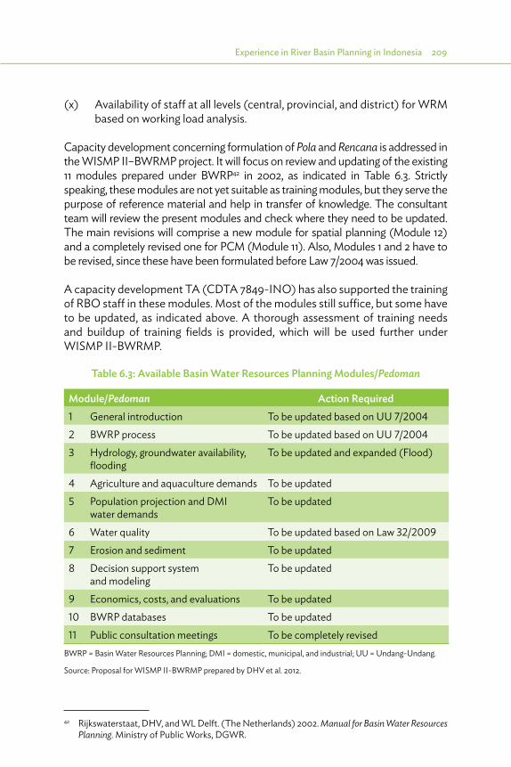
Experience in River Basin Planning in Indonesia 209
(x) Availability of staff at all levels (central, provincial, and district) for WRM based on working load analysis.
Capacity development concerning formulation of Pola and Rencana is addressed in the WISMP II–BWRMP project. It will focus on review and updating of the existing 11 modules prepared under BWRP42 in 2002, as indicated in Table 6.3. Strictly speaking, these modules are not yet suitable as training modules, but they serve the purpose of reference material and help in transfer of knowledge. The consultant team will review the present modules and check where they need to be updated. The main revisions will comprise a new module for spatial planning (Module 12) and a completely revised one for PCM (Module 11). Also, Modules 1 and 2 have to be revised, since these have been formulated before Law 7/2004 was issued.
A capacity development TA (CDTA 7849-INO) has also supported the training of RBO staff in these modules. Most of the modules still suffice, but some have to be updated, as indicated above. A thorough assessment of training needs and buildup of training fields is provided, which will be used further under WISMP II-BWRMP.
Table 6.3: Available Basin Water Resources Planning Modules/Pedoman
Module/Pedoman Action Required1 General introduction To be updated based on UU 7/20042 BWRP process To be updated based on UU 7/20043 Hydrology, groundwater availability,
floodingTo be updated and expanded (Flood)
4 Agriculture and aquaculture demands To be updated5 Population projection and DMI
water demandsTo be updated
6 Water quality To be updated based on Law 32/20097 Erosion and sediment To be updated8 Decision support system
and modelingTo be updated
9 Economics, costs, and evaluations To be updated10 BWRP databases To be updated11 Public consultation meetings To be completely revised
BWRP = Basin Water Resources Planning; DMI = domestic, municipal, and industrial; UU = Undang-Undang.
Source: Proposal for WISMP II-BWRMP prepared by DHV et al. 2012.
42 Rijkswaterstaat, DHV, and WL Delft. (The Netherlands) 2002. Manual for Basin Water Resources Planning. Ministry of Public Works, DGWR.

7 Suggestions for the Way Forward
7.1. Introduction
This chapter provides an overview of the challenges identified in this document and suggestions for the way forward. They follow the items discussed in Chapters 3 and 4 (legal and institutional aspects), and in
Chapter 6 (experience in river basin planning in Indonesia). The first two subchapters address the challenges and recommendations concerning legal and institutional aspects. The third and fourth subchapters address the process during formulation of the plan and the follow-up in implementation of the formulated plans, emphasizing consistency of annual plans with the long-term plans and adherence to its directions.
7.2. Legal Framework
7.2.1. Challenges in Legal FrameworkLaw 7/2004 on water resources represents a huge step forward in the implementation of Integrated Water Resources Management (IWRM) principles in national legislation. The scope of the law is integrated and as such geared toward all types of water resources, including river basins, aquifers, irrigation systems, lowlands, dams, drinking water, and sanitation systems. The law is also a real management act, in which development (construction including rehabilitation) and operation and maintenance (O&M) have all been given equal importance.
Law 7/2004 is a framework act. The majority of issues are regulated only in broad terms. Subordinate government regulations (PPs) must elaborate this to determine the specific legal standard for each of those issues. The Government of Indonesia has elected to draw up separate PPs for the different aspects of water resources management (WRM). This approach has led to considerable overlap and duplication and has resulted in a legal framework that may prove confusing in practice. Harmonizing and integrating the various regulations is inevitable. In general, distribution of authorities and responsibilities is in
Suggestions for the Way Forward 211
line with the decentralization concept. However, it is to be noted that the responsibility of the central government for the O&M of irrigation systems of more than 3,000 hectares is not fully in accordance with the decentralization concept. This is important, because in most provinces irrigation will present the most number of WRM issues. Its logic is mainly in terms of available budget: the central government usually has more budget than the provinces and districts. But a lack of sufficient staff capacity has forced the Government of Indonesia to mandate the provinces to execute the normal O&M activities (including in river basin territory or Wilayah Sungai [WS] for which the central government is directly responsible); it is questionable whether this is an acceptable solution for the long term.
The planning system represents an integrated approach at the strategic level. However, although the approach to planning is integrated in terms of ensuring close coherence within water management, the same does not apply to coordination with spatial planning. This is a matter for concern, because many water projects have major spatial consequences and, conversely, many spatial interventions initiated by other sectors have major consequences for water management. An explicit, binding set of rules for harmonization between the two forms of planning is of crucial importance.43
Public participation in the planning process is a key principle of IWRM and is expressed in Law 7/2004. However, in practice, the planning system still has a rather top-down character. Public consultation in the final stage of discussing a draft plan and public participation from the first stage of the planning process are two different things. Implementation of a bottom-up approach still has a long way to go.
Water use for basic daily needs and for small-scale farming in existing irrigation systems is free of licensing. All other types of water use need a license. Use of surface water and groundwater is regulated separately in two different PPs. Each gives only basic provisions, while other regulations on specific aspects of WRM provide further detail. Taken together, this shows a disintegrated approach with a lot of overlap and duplication. Moreover, the system does not distinguish between small-scale and large-scale water use. This imposes unnecessary heavy procedural requirements on small-scale users; due to limited staff resources, the government is actually unable to implement the same heavy regulatory approach to all types of users. Introduction of a differentiated licensing system can help solve this problem.
43 In the Netherlands, water interests in spatial plans are safeguarded through mandatory Water Assessments.
212 River Basin Management Planning in Indonesia: Policy and Practice
Water use for basic daily needs and for small-scale farming in the existing irrigation systems is free of charge; all other types of water use can be subjected to a WRM service fee in accordance with the cost recovery principle. In practice, the implementation of the service fee for water services is limited to water supply for bulk water, and for drinking water. Other types of water use and flood management are still not subjected to a WRM fee. Widening the scope of the service fee is a sensitive issue but is urgently necessary to develop and sustain the capacity for reliable WRM.
A final general observation relates to enforcement. Law 7/2004 contains only criminal sanctions (fines and even imprisonment), leaving administrative sanctions (e.g., withdrawal of permit) to the government regulations. It is desirable to focus in practice on administrative sanctions. This is much more pragmatic, because the sanctions relate directly to the utilization of water by the transgressor and, moreover, the competent authority can apply these sanctions without having to involve the police and the public prosecutor. The use of criminal sanctions should be reserved for typically criminal activities. For most situations, administrative sanctions are more efficient and effective.
7.2.2. Recommendations for Legal Framework Government regulations on budgeting for intersectoral projects should be formulated aimed at supporting integrated implementation, instead of the present sector-oriented arrangements with separate responsibility and accountability per sector. Only in this way can the so-called “sector ego” be diluted. Overall harmonization of PP under the laws is recommended. Preferably this should be done in one general PP for one law. In the present 12 PPs under Law 7/2004, overlaps and gaps could not be avoided.
Better use should be made of spatial plans in the basin WRM plans, and new spatial plans should be based on the Pola and Rencana.
(i) A mandatory check on the WRM requirements for spatial planning is recommended to reduce building in vulnerable catchment zones or flood zones, as well as in areas needed for WRM facilities such as dams and reservoirs, rivers, retention reservoirs, etc.
(ii) Spatial planners need to provide water resources planners with essential input on spatial plans, socioeconomic developments, and projections of land-use changes as input for water demand and emission calculations.
(iii) Spatial planners should support the enforcement of the spatial plans and WRM plans as binding in issuing permits and similar guidance in development. Special attention is needed for Food Security Law 41/2009.
Suggestions for the Way Forward 213
(iv) Building codes should be adapted and enforced, especially to guide development in new urban areas and to prepare these areas for optimal future sanitation and flood mitigation plans.
(v) Base protection area zoning on actual land use instead of landownership. Current protection areas have often already been converted. For Java, the protection area owned by Perhutani consists of only 19% of forest. The legal status of the land users of the remaining 81% of the area is unclear.
7.3. Institutional Framework and Capacity Building
7.3.1. Challenges in Institutional Framework 7.3.1.1 Distributed Responsibilities for Basin Management
Effective and efficient WRM would benefit from strong basin management organizations with independent funding and sufficient capacity to be in command of the entire WRM process (planning, development, resource exploitation, operation, maintenance, monitoring, and evaluation). There have been proposals in the past (e.g., by Basin Water Resources Management Planning [BWRMP]) to establish such institutions in Indonesia. However, the Government of Indonesia does not contemplate establishment of such organizations for the management of river basins, as it considers WRM as a multisectoral activity in which no institution belonging to a single sector (such as a water resources department belonging to PU) may control the activities of departments in other sectors.
The legal and institutional setup in Indonesia therefore reflects a two-pronged approach to IWRM. On the one hand, there is institutional management in the form of the river basin management organizations [B(B)WS], while on the other hand, much stock is placed on management through coordination, as reflected in the development of the Dewan and Basin Water Resources Management Council (TKPSDA). This is also where stakeholder participation is organized, which is generally considered a quintessential element of IWRM, and therefore contributes to the strength of these platforms. The Government of Indonesia expects that cooperation between the B(B)WSs and the Dewans and TKPSDA will result in effective basin management. However, several shortcomings on both sides of this equation means that this will take some time to come into being.
214 River Basin Management Planning in Indonesia: Policy and Practice
7.3.1.2 Institutional Water Resources Management
The position of the B(B)WS is strong on paper because it comprises all relevant functions for basin management, but it is diluted in practice. In part, this is the result of distributing different aspects of WRM to different institutions [catchment conservation, groundwater, environment, and enforcement are not the tasks of the B(B)WS]. It is also the result of a continued focus in the B(B)WS on major development and rehabilitation projects, since Directorate General for Water Resources at Ministry of Public Works (DGWR) placed the project managers (PPK) responsible for financial and technical implementation of water infrastructure development sponsored by the central government in the B(B)WS. This senior and well-developed capacity for development contrasts sharply with the limited capacity in the B(B)WS for managing basin operations. Clearly, operational priorities in practice are not in line with formal responsibilities of the B(B)WS on paper.
7.3.1.3 Management through Coordination
The Dewan and TKPSDA each comprise membership of all relevant government agencies and a wide range of community interests (nongovernment organizations [NGOs]) on an equal basis. However, coordination with so many and such varied parties is inevitably fraught with difficulty, and IWRM planning and operation continues to be weak. Moreover, the link with plan implementation (through monitoring and evaluation [M&E]) is poorly developed.
The legal framework gives important roles to both the institutional and coordinative frameworks, and seeks to create synergies from the collaboration between the two through a web of interrelationships in the planning and implementation process. Viewed from afar, it may seem that the Dewan or TKPSDA acts as a sort of multisectoral policy board, while the B(B)WS is in charge of implementation. However, the B(B)WS is not the only institution with important responsibilities for implementation, especially when it comes to basin conservation, law enforcement, and spatial planning. Moreover, the Dewan and TKPSDA do not have the final say over all activities of the B(B)WS, at least not in the sense that they can reject funding for its programs and work plans.
This situation is further exacerbated by the fact that some may view the B(B)WS to be a formally much stronger institution than the coordinating bodies that it must support: while it has its own staff establishment and budget, the Dewan and TKPSDA are so-called nonstructural organizations and are unable to provide resources for their own strengthening. The B(B)WS is supposed to

Suggestions for the Way Forward 215
support TKPSDA with a permanent secretariat, but this could be against their interests, creating a strong policy board.
Yet, the Dewan and TKPSDA have considerable intrinsic strengths. Not only do they embody the participatory stakeholder approach to basin management but they also have been established at levels of considerable authority. The governor chairs the Dewan SDA, and the head of Regional Development Planning Agency (BAPPEDA), with delegated responsibility for cross-sectoral planning, chairs the TKPSDA. The chairs not only have the power to guide the participating agencies in planning but also to make sure that they actually implement their share of the plan. In particular, the governors formally have a strong position in this, as it is their job to coordinate all government activities in the province—not only those of provincial and local government institutions but also those of central government departments operating in the province, in their position as representative of the central government.
Even with delegated power only, the heads of BAPPEDA are also formally well-positioned to provide strong leadership to the TKPSDA because they also control the annual planning process for budget preparation (Musrenbang), and should therefore be able to ensure that the participating agencies “put their money where their mouth is.” However, the Dewan SDA and TKPSDA represent just two of the many forums chaired by the governor or the head of BAPPEDA, whose actual involvement therefore will depend very much on personal interest and the pressures of their agenda, and could easily become a formality.
7.3.1.4. Giving “Teeth” to Coordination by TKPSDA
The Dewan SDA and/or TKPSDA could potentially become very effective if they are able to act as “provocateurs” not only in formulating good WRM plans but also in defense of adherence to the plan by monitoring whether actual implementation results in effective progress in the planned direction. If the stakeholders participating in these coordination platforms attach sufficient importance to their performance, the Dewan and TKPSDA can use their legal mandate to push the B(B)WS and the relevant provincial and local government agencies responsible for water security to cooperate with other institutions that are responsible for such diverse aspects, such as conservation of catchments (forestry, agriculture); water quality (environment, human settlements); water distribution (public water supply companies); mitigating the potential damage brought about by water through floods and drought as well as landslides (local government); spatial planning (BAPPEDA); etc.

216 River Basin Management Planning in Indonesia: Policy and Practice
At the institutional level, harvesting the potential synergies of the distributed responsibilities for basin management requires making the B(B)WS and TKPSDA mutually dependent. A major step toward this goal could be giving the TKPSDA the power to accept or reject work plans and budgets to the B(B)WS. It would then have an interest in making something of the secretariat function to ensure a good planning process and outcome, while the stakeholders in the TKPSDA would have actual influence on implementation, for which it would, of course, be necessary to invest in significant strengthening of the TKPSDA to a level of real representation of interests, among other things through organization of stakeholders, systems for (s)election of representatives, and development of associated accountability mechanisms.
7.3.1.5. Linking with Spatial Planning to Implement Basin Conservation
Law 26/2007 gives all levels of government the same authority for spatial management but does not specify what is of provincial scale and what is of local scale. The beginning of a solution may be found in PP 38/2007 on the distribution of tasks between levels of government. This regulation lists spatial management as a “shared task,” that is, one for which all levels have some responsibility. According to this regulation, a shared responsibility is to be distributed based on criteria for externalities, accountability, and efficiency. The externality perspective argues for a strong guiding role of higher-level government, for example, by setting boundaries for spatial utilization, while the efficiency perspective would place the formulation and implementation of specific zoning regulations at the local level. For example, the province could propose limitations to development on riverbanks in flood-prone areas, or in vulnerable watersheds, and include this in the spatial plans. Then the kabupaten, will have to follow this in their spatial plans (RTRW). As such, this becomes a legally enforceable limitation on lower-level spatial planning.
An explicit, binding set of rules for harmonization between spatial planning and WRM planning is of crucial importance to set up such binding rules for boundary conditions to guide zoning. The challenges to derive zoning include quantification of
(i) interaction between space and WRM, for example, runoff and erosion; and(ii) impact on the water resources aspect associated with spatial control
interventions.
In particular, information on runoff protection zoning is very scarce; there is practically no quantification available for zoning for runoff protection from
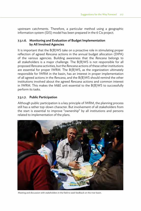
Suggestions for the Way Forward 217
upstream catchments. Therefore, a particular method using a geographic information system (GIS) model has been prepared in the 6 Cis project.
7.3.1.6. Monitoring and Evaluation of Budget Implementation by All Involved Agencies
It is important that the B(B)WS take on a proactive role in stimulating proper reflection of agreed Rencana actions in the annual budget allocation (DIPA) of the various agencies. Building awareness that the Rencana belongs to all stakeholders is a major challenge. The B(B)WS is not responsible for all proposed Rencana activities, but the Rencana actions of these other institutions are essential for proper IWRM. The B(B)WS, as the organization ultimately responsible for IWRM in the basin, has an interest in proper implementation of all agreed actions in the Rencana, and the B(B)WS should remind the other institutions involved about the agreed Rencana actions and common interest in IWRM. This makes the M&E unit essential to the B(B)WS to successfully perform its tasks.
7.3.1.7. Public Participation
Although public participation is a key principle of IWRM, the planning process still has a rather top-down character. But involvement of all stakeholders from the start is essential to improve “ownership” by all institutions and persons related to implementation of the plans.
Meeting and discussion with stakeholders in the field to seek feedback on the river basin.
218 River Basin Management Planning in Indonesia: Policy and Practice
These measures aimed at giving more “teeth” to the TKPSDA may improve the concept of “shared ownership,” essential for the full integration of the existing strategic plans (such as spatial plans, environmental plans, etc.) and public aspirations into the basin plan, as well as integration of the basin plans into the new or to be updated strategic plans and public aspirations, and for creating awareness to support implementation of the plans.
7.3.2. Challenges in Capacity Concerning the capacity for WRM, it is not realistic to expect that the B(B)WS will be staffed with sufficient personnel to operate all facilities, and the present arrangement where most of this is delegated to the provinces and districts works reasonably well. However, clear distribution of responsibilities should be arranged to avoid “fuzzy” situations in case of emergencies. Examples exist of a comprehensive official memorandum of understanding (MOU) between the various institutions involved, and adequately formulated Pola and Rencana could be instrumental to that.
This is also needed in case the beneficiaries contribute more to cost recovery, and the provided services and the cost incurred have to be transparently audited for the users paying for those services. In increasing numbers of irrigation schemes are well-organized water users associations, frequently not only established at tertiary level but also at secondary and primary levels (water user association federations). These organizations are a potential source for adequate numbers of operators, to be trained in well-focused training courses, and supervised by irrigation overseers from the Irrigation agency, preferably one per 1,000 hectares.
7.3.3. Recommendations on Institutional Aspects and Capacity Building
Based on above challenges, the recommendations are as follows:
(i) Enhance the role of the Dewan and TKPSDA as policy makers, by giving them full insight into the budgets available for IWRM in the different sectors, and the power to comment on that. The Dewan will concentrate on the Dinases related to IWRM (Dinas PSDA, Dinas for groundwater, environmental board, etc.) while TKPSDA will concentrate on the institutions related to the basin: B(B)WS, Balai PSDA – Balai Pengelolaan Sumber Daya Air (WRM center at the provincial level), and also Balai PDAS from forestry, and its relation with Forum Daerah Aliran Sungai or river basin/watershed.
Suggestions for the Way Forward 219
(ii) Strengthening of the TKPSDA to a level of real representation of interests, among other things through organization of stakeholders, systems for (s)election of representatives, and development of associated accountability mechanisms. This will also enhance the awareness that WRM is a shared aspect, and “joint ownership” of the Pola and Rencana is required for integrated implementation of the plans.
(iii) Integration of all forums related to natural resources, such as TKPSDA, but also the Forum DAS (Forestry) and some environmental boards (as established for Lake Toba).
(iv) Capacity building of members of the Dewan and TKPSDA, especially concerning assessment of impacts of various plan components, and monitoring of performance of the related institutions.
(v) The B(B)WS focuses more on main operational tasks, clearly separated from project implementation tasks.
(vi) More integrated management approach, supported by incentives for cooperation between WRM institutions with institutions for forestry, agriculture, environment, and groundwater.
(vii) For better integration of spatial and WRM planning, developing an explicit, binding set of rules for harmonization between the two forms of planning is of crucial importance.
(viii) Legalization of guidelines for quantification of interactions between spatial and WRM planning, which could build further on the models already prepared under 6 Cis:a. quantification of the process of interaction between space and the
particular water resources aspect (especially runoff, erosion); andb. quantification of the impact on the water resources aspect associated
with controlling interventions.(ix) The B(B)WS should take on a proactive role in stimulating proper
reflection of agreed Pola and Rencana actions in the DIPA of the various agencies, because the Pola and Rencana belong to all stakeholders. The B(B)WS is not responsible for all proposed Pola/Rencana activities, but the actions of these other institutions are essential for proper IWRM. The B(B)WS, as the organization ultimately responsible for IWRM in the basin, has an interest in proper implementation of all agreed actions in the Rencana, and it should remind the other institutions involved about the agreed Rencana actions and common interest in IWRM.
(x) Establishment of an adequate M&E unit in the secretariat of the TKPSDA for budget expenditures related to IWRM is essential for the B(B)WS to successfully perform its tasks.

220 River Basin Management Planning in Indonesia: Policy and Practice
(xi) Establish clear task distribution between the various agencies involved in IWRM. This will avoid overlaps and identify the gaps.
(xii) Stimulate cost recovery through a WRM service fee that is provided in Law 7/2004. This does not have to be a high fee: incidental calculations of development and O&M funding needs in several basins have shown that cost recovery for all aspects of WRM, including infrastructure development, should not impose an insurmountable burden if compared with indicators such as nonfood household spending or real estate tax on buildings in the basin.
(xiii) Cost recovery will also raise awareness about the real cost of the water services (both supply and protection). In this way, the users themselves will reduce their water needs, reducing spillage.
7.4. Planning Process
7.4.1. Challenges in the Planning Process 7.4.1.1. Developing a Shared Vision
Developing a shared vision during the planning process is not only one of the big challenges in this stage but also a unique opportunity to establish better coordination. Collecting and validating data from all different sectors enable exchange of information between the sectors and create awareness about different views on the perceived “facts,” aiming to establish trust among the different stakeholders about common values and aims, and establish a bond as between partners for the same cause. This trust is conducive for sharing information between these partners and for better coordination.
But, this requires commitment from the relevant sectors for substantial involvement during the planning process. There should be ample opportunities for the various sectors to contribute, not only to the public consultation meeting (PCM) but also during focus group discussions (FGDs). These meetings should be attended by senior staff, with sufficient information to contribute to the process, and sufficient decision-making power to make the process effective. Integration during the process of plan formulation can be improved by making more effective use of the TKPSDA, which has been established almost everywhere.
7.4.1.2. The Pola as a Strategic Document
The Pola is supposed to be a strategic plan that outlines the long-term objectives (20 years) and the principles to be used in developing and managing the water resources, and addresses the main issues, priorities, and milestones,
Suggestions for the Way Forward 221
to achieve the required socioeconomic development in the basin. The Rencana is supposed to translate the Pola into a more operational plan with priorities and selection of preferred solutions. The description of the measures should be at the prefeasibility level. One might expect that the focus on the strategic level will require a Pola document of about 25 to a maximum of 40 pages, while a Rencana will most probably be much more extensive and have many supporting documents.
The Ministry of PU has provided guidelines for the preparation of the Pola and Rencana. The guideline for the Pola requires that detailed information be included in the plan. As a result, Polas have become extensive documents in which it is sometimes difficult to find the main issues that need to be addressed and the strategic decisions and guidelines that should be followed. Moreover, the guidelines specify that economic and financial analysis will only be addressed in the Rencana and not in the Pola. It is difficult to come to strategic decisions in a Pola because the cost and benefits are not highlighted.
7.4.1.3. Guidelines for Plan Preparation (Analysis Process)
There is not much experience in Indonesia with developing these kinds of integrated plans. Responsible organizations have expressed a strong need to get clear guidelines on how to carry out this planning: which analysis steps to take, what the depth of analysis should be, how to link their plan with other sector plans and national objectives, how to deal with future uncertainties (scenarios), how to present the results not only at the level of the WS but also at a provincial and kabupaten levels, and so on. The present guidelines are considered insufficient. The outcome is that the first round of planning has resulted in a wide variety of plans of different depth and quality. Some plans were prepared based on many person-years’ worth of input of consultants and government staff. Other plans were simple consultant reports prepared in a short period of only a few months with much cut-and-paste content.
Having better guided plans is important not only for the quality of the plans (and the chance that they will be accepted and implemented) but also to enable other government institutions (horizontal and vertical) to make links between the plans (e.g., for interbasin transfer) or to compile the outcome to a higher level (province or national).
7.4.1.4. Planning Methods, Models, and Data
At a more practical level, there appeared to be a great need for guidance on how to carry out an analysis. This includes simple things such as how to determine the demand for and ensure supply of water and also how to deal with more complex issues such as climate change. Although the need for guidelines was
222 River Basin Management Planning in Indonesia: Policy and Practice
expressed clearly, it also appeared that available guidelines (Pedoman Teknis) were not intensively used. The reason was that the staff involved (government, consultants) were not aware of the existence of these documents and/or that these guidelines were insufficient and needed to be updated and extended.
In addition to clear guidelines, a uniform set of methods and models should be made available. This will not only help in the preparation of the plans but will also make the plans more consistent. On the contrary, the water resources conditions in a big country such as Indonesia vary widely which calls for flexibility in applying different methods and models, if required by the conditions or the availability of data.
A general constraint on good planning in Indonesia is the lack of good-quality data. There are multiple data sources but these data are often not easily available and sometimes not consistent (e.g., rainfall data from BMKG, PU, Pertanian, Kehutanan, etc.). Recent nationwide governmental initiatives such as OneMap and SIH3 are supposed to improve this situation.
7.4.1.5. Planning Capacity
A last point mentioned frequently is the lack of planning capacity to carry out the kind of integrated analysis as needed for IWRM. This is not only the case for all levels of government (national, provincial, kabupaten) but also for the consultants being hired to carry out the supporting studies and even the cc that are sometimes involved in guiding the process. Specific training will be required for the different target groups, for example, the decision makers and stakeholders need training and workshops on the role of the plans, while consultants and others actively involved in analysis of the plans should get trained on the analysis process, methods, models, and data.
7.4.1.6. Contents of the Pola
The Pola should include the matrix and the thematic maps to illustrate the proposed operational policies. Integration with spatial planning should be specifically made mandatory, showing the impacts of the spatial plan on WRM (urban area with requirements for water supply and protection) as well as indicating what the Pola requires to be included in the next spatial plan (protected zones to reduce erosion, or zones with building codes for infiltration or preparation for floods), showing some examples on how to implement both aspects. Also, public announcement before legalization of the Pola (as already in the Rencana) is suggested.
Suggestions for the Way Forward 223
7.4.2. Recommendations Concerning the Planning Process 7.4.2.1. Overview
In general, the planning process can be improved by
(i) more focus on the shared vision on present status and preferred future development;
(ii) more focus on the planning process; (iii) improving the guidelines for the Pola and Rencana, with more attention for
the development of a shared vision and how to steer the planning process to come up with suitable solutions; and
(iv) several implementation aspects.
7.4.2.2. Development of Shared VisionThe shared vision should focus on a common vision about the present status of IWRM and the preferred development, as well as on the translation of targets for development stated in the regional development plans into targets for WRM. This should be realized by organizing FGDs with a limited number of stakeholders with common issues, with more possibilities to go into the details, and enhancing adaptation of diverse views into an agreed vision. FGDs will discuss the issues and options for improvement and formulate a shared vision, and, as such, the FGD is a preparation for the PCMs, attended by many more stakeholders, which should be used only to confirm what already has been achieved in the FGD.
To enhance this integrated approach, the lead in the Pola process could be given to the regional BAPPEDA, instead of the present arrangement with the B(B)WS or Dinas PSDA in charge. Of course, the lead experts will be from the B(B)WS, but the persons steering the direction will be from BAPPEDA, and they are responsible for regional development and intersectoral involvement.
7.4.2.3. More Focus in the Planning ProcessThe planning process should focus more on the main issues and selection of various options for required measures and strategies to realize the envisaged future development. The resulting product should provide more information on the main issues and the merits of the identified solutions, when comparing these with alternative solutions. Less attention could be paid to generic solutions in the form of awareness campaigns or strengthening of farmers’ organizations.

224 River Basin Management Planning in Indonesia: Policy and Practice
These are important and should be included in each plan, but the need for such measures is evident, and the methods are applicable almost everywhere, and therefore do not need much attention for justification.
Having more focused plans is important not only for the quality of the plans (and the chance that they will be accepted and implemented) but also to enable other government institutions (horizontal and vertical) to make links between the plans (e.g., for interbasin transfer) or to compile the outcome to a higher level (province or national).
7.4.2.4. Improving the Guidelines for the Pola and RencanaImproving the guidelines for the Pola and Rencana as presented in KepMen PU 22/2009 (Pola) and KepMen PU 2/2013 (Rencana), with more attention on the shared vision and the proposed measures and less attention to some detailed requirements deviating attention from the main messages of the plans.
The Pola should present outlines for:
(i) the long-term objectives for development in the next 20 years with focus on direction of development (either food production or urbanization, development of own resources, or transfer from other basins, etc.) and also on standards (envisaged target for food production, water supply standards and targets for coverage, etc.) reflecting the shared vision;
(ii) the principles to be used in developing and managing the water resources (water quality standards; unit rates of water to be supplied to households, industries, and irrigated fields; protection to be provided [once in 10 or once in 100 years?]);
(iii) issues and possible solutions; (iv) screening of solutions, resulting in principal priorities and milestones, to be
confirmed by the TKPSDA; and(v) formulation of matrix for operational policies, already indicating results of
screening.
The Rencana should focus more on translation of the Pola into a more operational plan, indicating priorities and preferred solutions (prefeasibility level), and present outlines for:
(i) the specific sequential midterm objectives for development (food production, water supply standards and coverage, etc.), reflecting the shared vision;
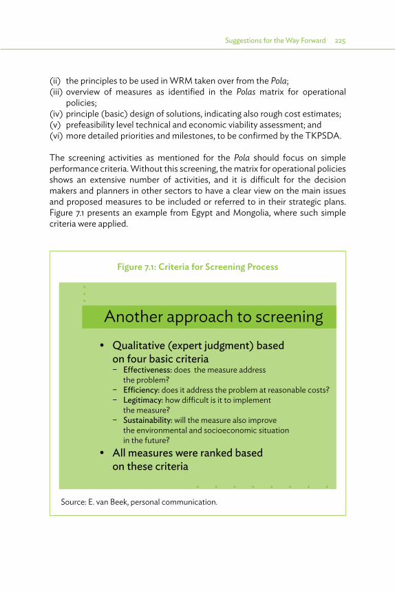
Suggestions for the Way Forward 225
Figure 7.1: Criteria for Screening Process
Another approach to screening• Qualitative (expert judgment) based on four basic criteria – E�ectiveness: does the measure address the problem? – E�ciency: does it address the problem at reasonable costs? – Legitimacy: how dicult is it to implement the measure? – Sustainability: will the measure also improve the environmental and socioeconomic situation in the future?• All measures were ranked based on these criteria
Source: E. van Beek, personal communication.
(ii) the principles to be used in WRM taken over from the Pola;(iii) overview of measures as identified in the Polas matrix for operational
policies;(iv) principle (basic) design of solutions, indicating also rough cost estimates;(v) prefeasibility level technical and economic viability assessment; and(vi) more detailed priorities and milestones, to be confirmed by the TKPSDA.
The screening activities as mentioned for the Pola should focus on simple performance criteria. Without this screening, the matrix for operational policies shows an extensive number of activities, and it is difficult for the decision makers and planners in other sectors to have a clear view on the main issues and proposed measures to be included or referred to in their strategic plans. Figure 7.1 presents an example from Egypt and Mongolia, where such simple criteria were applied.

226 River Basin Management Planning in Indonesia: Policy and Practice
7.4.2.5. Implementation AspectsSome implementation aspects concern the following recommendations:
(i) Contracting consultants for the whole process of Pola and Rencana formulation or review, not cutting it into several small annual stages.
(ii) Capacity development of more consultants and university staff should be arranged to have more capacity available to formulate good Pola and Rencana, or to implement adequate reviews. This should also comprise capacity building for supervising staff in the B(B)WS, Dinas PSDA, so that they can prepare adequate Terms of Reference for the consultants, with sufficient budget allocation, and can closely follow the process to make optimal use of the final product.
(iii) Provide more detailed guidance on how to carry out an analysis. The KepMen PU indicates what has to be done, but not how that has to be done. This concerns simple things such as how to determine the demand for and supply of water or how to deal with more complex issues such as climate change. Updating the available guidelines (Pedoman Teknis)44 is probably the best option to quickly develop these guidelines. But since these were not intensively used, an extensive training program is needed to make the staff involved (government, consultants), thereby more familiar with the contents and available tools.
(iv) In addition to clear guidelines, a uniform set of methods and models should be made available. This will not only help in the preparation of the plans but will also make the plans more consistent. However, it should also be noted that the water resources conditions in a big country such as Indonesia vary widely, which calls for flexibility in applying different methods and models, if required by the conditions or the availability of data.
(v) A general constraint on good planning in Indonesia is the lack of good-quality data. Optimal use should be made of recent nationwide governmental initiatives such as OneMap and SIH3, which are supposed to improve this situation.
Integration during the process of plan formulation can be improved by making more effective use of the recently established TKPSDA. Effective use of consultation meetings should be made:
(i) The PCM should not only comprise presentation by consultants or B(B)WS but also comprise presentations from other sectors to enhance participation of senior staff members.
44 Guidelines for Basin Water Resources Planning, prepared by JIWMP-BWRP for DGWR. 2002.

Suggestions for the Way Forward 227
(ii) The FGDs should be used to address specific stakeholders and/or specific subjects. If stakeholders are addressed more attentively during the PCM, they may be more willing to contribute.
(iii) Such an individual approach could ensure a more effective use of the private sector through business participation in public–private partnership or through cost recovery. This could also make all stakeholders more aware of the value of water for different uses (water is still a social good to which all people should have access for essential needs, but it is also a precious economic entity).
7.5. Enhancing Implementation of the Pola and Rencana
7.5.1. Challenges in Intersector Approach The challenges of natural resources scarcities in water, food, and energy are closely interlinked, and policies or other solutions must take this into account. But, it is almost impossible for most institutions to take an integrated view of such issues, given the complexity of the matter and the conflicting interests of a cross-sectoral approach. The “sector ego” is still strong and is embedded in the way the budgets and financial incentives are arranged. It takes brave political will to take bold action.
The TKPSDA is meant to break through these “sector egos” and address the actual needs in the field. As such, the sector agencies should be “service oriented” and should mobilize its resources in cooperation with other sector agencies toward addressing the needs of the users. The B(B)WS could play an active role in this. In the successful example of Bengawan Solo, the head of the secretariat of the TKPSDA was the head of the planning division in the B(B)WS.
The head prepared the agenda for the meetings, provided the background information for the decisions to be taken, and followed up by reminding the various agencies and other members about the agreed actions. This greatly contributed to the quality of the Pola and Rencana, and integrated the implementation of water resources development and WRM.
Enforcement of implementing the Pola or Rencana will be difficult, but especially its link with spatial planning provides opportunities. Issuance of licenses to build should be in line with the spatial planning zones and building codes, as well as the prepared WRM plans. Through preparation of detailed maps indicating the
228 River Basin Management Planning in Indonesia: Policy and Practice
extent of the different zones identified in the spatial plan, it will be possible to facilitate evaluation whether permits for development can be issued. Also consultation with the requirements of the Pola or Rencana should be required. This will reduce building in vulnerable catchment zones, and also reduce development in areas needed for WRM facilities, such as dams and reservoirs, rivers, retention reservoirs, and flood zones.
7.5.2. Position of the Pola and Rencana in Relation to Other Governmental Activities
As stated in Section 2.4, IWRM is not a goal by itself but aims to support economic and social welfare. For that reason, the Pola and Rencana should be based on the sector objectives and programs (MDGs, agriculture, energy, public health, environment, spatial planning, etc.) as starting conditions. Moreover, these other sectors should see the Pola and Rencana as additional instruments to realize their objectives. They should “own” the plans. A problem in this respect is that the translation of national objectives (e.g., on food and energy) in Indonesia is insufficiently transformed into boundary conditions for river basins. This might require a three-step approach: from national objectives to objectives by island (group) to objectives by river basin.
The present reality is that the link between water and sector objectives is often rather weak. Many stakeholders consider the Pola and Rencana as documents that have to be drafted for the Ministry of Public Works (MPW) (PU) in Jakarta. It proves difficult to get the stakeholders involved. Also, the private sector and NGOs could be more active in the IWRM process. At the same time, quite a lot of Polas and Rencanas developed so far are too restricted, focusing on typical PU tasks such as irrigation and flooding and hardly pay any attention to higher-level goals such as Millenium Development Goals and food and energy security. The basic notion that water resource institutions are supposed to provide services to enable others to reach those goals is still rather weak in Indonesia. There is a clear need for showing all stakeholders the added value of having a good Pola and Rencana process.
Suggestions for the Way Forward 229
7.5.3. Recommendations Concerning Enhanced Adherence and Application of the Pola and Rencana
There are several measures to enhance adherence and application of the Pola and Rencana:
(i) Preparation of the Pola under the leadership of BAPPEDA could assist in enhancing “co-ownership.” The B(B)WS can provide professional assistance, but the lead should come from the BAPPEDA, which has more leverage over all agencies that should contribute to the Pola and eventually follow the direction of the Pola.
(ii) Another suggestion is already implemented by the DGWR and requires that projects proposed for funding can only be approved if they are mentioned in the Pola or Rencana.
(iii) It is recommended to ensure that water security is included in the Rencana Pembangunan Jangka Menengah Nasional (National Medium-Term Development Plan, RPJMN). If this is included in the RPJMN, this will be followed by the provinces and districts. It will enhance implementation of the plans formulated in the Pola and Rencana, but it is also recommended to ensure that specific proposals in the Pola and Rencana are also taken up in the Rencana Strategis (strategic plans) of specific institutions.
(iv) The Pola and Rencana should be the leading documents for the B(B)WS and Dinas PSDA. But the B(B)WS and Dinas should also be proactive to promote inclusion of items from the Pola in other strategic documents (RENSTRA). The B(B)WS should stimulate proper reflection of the agreed Pola and Rencana actions in the DIPA of the various agencies, emphasizing that the Pola and Rencana belong to all stakeholders. The B(B)WS is not responsible for all proposed Pola and Rencana activities, but the actions of these other institutions are essential for proper IWRM. The B(B)WS, as the organization ultimately responsible for IWRM in the basin, has an interest in proper implementation of all agreed actions in the Rencana, and the B(B)WS should remind the other institutions involved about the agreed Rencana actions and common interest in IWRM.
(v) Establishment of an adequate M&E unit in the secretariat of the TKPSDA for budget expenditures related to IWRM is essential for the B(B)WS to successfully perform its tasks, as already mentioned.
(vi) Stimulating cost recovery through a WRM service fee that is provided in Law 7/2004 will also enhance application of the Pola and Rencana, because only with these documents can the stakeholders be convinced that their contributions are necessary and will be used for their own benefit.

Index
Tables, figures, boxes, and notes are indicated by t, f, b, and n following page numbers.
6 Cis project agroeconomic analysis in, 163, 164t assessment of areas contributing to flooding, 150–52, 151–52f comparison with Road Map approach, 106 cost estimating relationships in, 159 data limitations in, 137 economic benefit analysis in, 165, 166t erosion studies in, 153 geographic information system model in, 217 governance scenarios in, 184 interaction of spatial and water resources planning in, 24, 24f, 25 on land and water management interrelationships, 129–33 objectives of, 5 operational costs for drinking water treatment plants, 162, 162t performance benchmarking tools in, 167 Pola for, 197, 198 policy analysis approach to basin planning in, 18, 19f reforestation efforts in, 112 strategies and scenarios in, 77–78b TKPSDA in, 194, 196–98 water management concerns in, 153 water quality management in, 169 zoning analysis in, 148
AADB. See Asian Development BankAdministrative sanctions, 42–43, 212Agency for Geographic Information (BIG), xxii, 206Agency for Research and Development in Water Resources (PusAir) data bank access, xxii on formulation of Polas and Rencanas, 27, 54 hydrological database development by, 138 simulation software developed by, 139, 142Agricultural land forests transformed into, 111 pollution from, 113, 114, 169, 170f

Index 231
spatial planning and, 125–26 zoning for protection of, 156–57, 157fAgroeconomic analysis, 163, 164tAnnual work plans (AWPs), 18, 57, 59, 61Anshori, Imam, 198, 200Ashari, Nidhom, 198Asian Development Bank (ADB) Java Spatial Model in studies by, 143 on performance benchmarking of river basin organizations, 165 Road Map interventions and, 105, 190 6 Cis project sponsored by, 5 on water security, 14Asian Water Development Outlook 2013 (ADB), 14AWPs. See Annual work plansAzdan, Donny M., 198
BBalai PSDA. See Provincial water resources management centersBandung (Indonesia) basin planning workshop in, 101–4 Citarum basin in. See Citarum basin land subsidence in, 135, 174 6 Cis project in, 5 urban development in, 145f, 146BAPPEDA. See Regional Development Planning AgencyBAPPENAS. See National Development Planning AgencyBasin status reporting, 19–20, 165, 167–68, 167–68tBasin Water Resources Management Centers (B(B)WS) Bengawan Solo basin and, 188 Brantas basin and, 187, 188 budget allocation and, 59 capacity development in, 218, 226 Citarum basin and, 190 cooperation with other government agencies, 213, 215–16 establishment of, 43, 50, 53, 64 institutional framework for, 20, 50 Jratunseluna basin and, 191 Pemali Comal basin and, 192–93 in Pola and Rencana implementation, 229 in policy formulation and planning, 27, 54, 64 Progo Opak Serang basin and, 192
232 Index
recommendations for, 219 responsibilities of, 214, 217Basin Water Resources Management Council (TKPSDA) Bengawan Solo basin and, 188, 227 Brantas basin and, 188 budget allocation and, 58, 59, 60 Citarum basin and, 190 cooperation with other government agencies, 213, 215–16 effective use of, 206, 226 establishment of, 193, 194, 196t formation of, 27 institutional organization of, 46 legal basis for, 17, 38n19 membership in, 194, 196, 214 Pemali Comal basin and, 192 Pola recommendations from, 93, 205 policy formulation and planning by, 38–39, 48–50, 64 recommendations for, 218–19 in 6 Cis project, 194, 196–98 stakeholders and, 4 strengths of, 215Basin Water Resources Management Planning (BWRMP) capacity for. See Capacity development challenges in, xx–xxi, 220–22 coordination requirements in, 2 criticisms of, 186, 199–200, 203–4 data analysis in, xxii institutional framework for. See Institutional framework island-wide approach to, 120–21 legal framework for. See Legal framework master plan for. See Rencanas methodological tools for. See Methodological tools objectives of, 199 opportunities for, xxii–xxv phases of, 2, 3f policy analysis approach to, 18, 19f recommendations for improvement, xxv–xxvii, 205–7 results of, 199–200, 202–3 risks of, xxv strategic framework for. See Polas strengths of, xix–xx for sustainable growth, xviii, 1B(B)WS. See Basin Water Resources Management CentersBengawan Solo basin, 188, 227

Index 233
BIG. See Agency for Geographic InformationBiological oxygen demand (BOD), 113, 146, 174, 175tBKPRD. See Regional Spatial Management Coordination BoardsBMKG. See Indonesian Institute for Meteorology, Climatology, and GeophysicsBody for National Parks, 110Bottlenecks in water utilization, 115, 116BPDAS. See Center for Catchment ManagementBPLHD. See Provincial Bureau of EnvironmentBPS. See Central Statistics AgencyBrantas basin, 10, 12, 13f, 46b, 187–88BTA-155 project, 10, 159, 189Budget allocation. See also Financing for basin development, 59–60 for CDAP, 208 fluctuations in, xxi for IWRM processes, 58 legal framework on, 57, 212 monitoring and evaluation of, 60, 217, 219, 229 Musrenbang process for, 57–59, 58f, 60 principles of, 57Building codes, 2, 146, 149, 213, 227BWRMP. See Basin Water Resources Management Planning
CCanadian International Development Agency, 191Canals design considerations for, 100 land for, 128 pollution in, 114 transport, 116 water quality in, 113Capacity development assessment of, 53–54 challenges in, 208, 218 deficits in, 207–8 defined, 208 importance of, xxi, 206–7 modules for, 209, 209t in planning process, 222 recommendations for, 218–20 requirements for, 208–9
234 Index
in Road Map approach, 108b training for, xxiv, 104, 208, 209Capacity development action plans (CDAPs), 106, 208Catchment conservation coordinating platform for, 20 intersector cooperation in, 202b rehabilitation program for, 156, 156t responsibility for, 45, 202b spatial planning for, 40, 153–57, 154–55f, 155–56t, 157f zoning for, 156–57, 157fCDAPs. See Capacity development action plansCenter for Catchment Management (BPDAS), 109, 112Central Statistics Agency (BPS), 125–26, 180CERs. See Cost estimating relationshipsChandra, Yunita, 198Change management teams (CMTs), 106Chemical oxygen demand (COD), 113, 114, 174, 175tCibeet River study, 189Cidanau basin, 29, 112–13Cirata Dam, 188Cisadane–Cimanuk Integrated Water Resources Development project, 10, 159, 189Citarum basin assessment of water management problem in, 147, 147f critical watershed in, 110, 111f dams and reservoirs of, 188, 189 erosion in, 153 land use in, 111, 112f, 154 physical basin performance benchmarking in, 165 Pola and Rencana for, 189, 190 public consultation meetings on, 190 Road Map approach in, 19, 104–5, 179, 190 textile industry in, 173–74 water balance in, 116, 117f water quality in, 113, 114f, 169Civil society organizations, xxiii, xxviClimate change data collection on, 68b scenarios for, 77–78b, 182, 184 WRM and, 13CLIMBER–2 model, 182, 182n38, 184CMTs. See Change management teamsCOD. See Chemical oxygen demandCoffee plants, 112–13Community-based sanitation systems, 171, 171t
Index 235
Community participation. See also Stakeholders methodological tools for, 118–19 operational policies matrix on, 76, 88–92t topics for discussion involving, 70b, 80bConcept matrix, 97, 98–99t, 101Conservation, 109–15. See also Catchment conservation analysis of aspects related to, 73, 73–74t comparison of alternative solutions for, 100 concept matrix on, 97, 98–99t financing for, 60 growing need for, 1, 22 of land and soil, 109–13, 133 legal framework on, 4 methodological tools for, 109–15 operational policies matrix on, 76, 81–82t topics for discussion involving, 70b, 79b of water quality, 113–15 of water quantities, 113 zoning for, 156–57, 157fCoordinating platforms benefits of, 187 for draft plans, 197 for equitable service provision, xxiii legal framework on, 27, 46, 193 objectives of, 20 for spatial planning, 2, 20 strategies for enhancing, xxiv water resources councils and, 17, 20Cost–benefit comparisons, 158Cost estimating relationships (CERs), 100, 158–60, 160–61t, 164Cost recovery mechanisms, xxi, xxiii, 212, 220Criminal sanctions, 42–43, 212Critical performance areas, 168Cultivated areas, classification of, 110
DDams comparison of alternative solutions for, 100 design considerations for, 100 intersector cooperation in construction of, 201bDarismanto, Nico, 199
236 Index
Data collection hydrological, 118, 137–38 procedures for, 67–69, 68–69b, 96 recommendations for improvement, 205–6Deltares, 5, 138, 139, 142Dewan SDA. See Provincial Water CouncilsDHV Consultants, 5, 113DINAS-COAST project, 182Directorate General for Water Resources (DGWR) capacity development and, 207–8 on data and information management, 118 plan and project approval responsibilities of, 26, 50, 64, 205, 229 6 Cis project and, 5Disasters analysis of aspects related to, 73, 75t data collection on, 69b methodological tools for management of, 117–18 operational policies matrix on, 76, 85–86t topics for discussion involving, 70b, 80bDistrict Water Resources Services, 64Domestic, municipal, and industrial (DMI) water users, 116Domestic–municipal interventions, 171–73, 171–72t, 172–73fDomestic–municipal pollution, 113, 169–71, 170fDrainage control, 135, 149–53, 151–52fDrinking water treatment plants, 161, 162, 162tDroughts, 8, 45, 68b, 117–18, 138DSS (River Basin Planning Decision Support System), 138–39Dublin principles, 8, 8–9b, 18
EEarly warning systems, xx, 138, 142Economic benefit analysis, 163–65, 166tEconomic development IWRM in support of, 7 scenarios for, 77–78b, 181–82, 183f water resource systems and, 8, 8bEnergy security, 14, 102, 200, 228Enforcement measures, 42–43Engineering, administration, and physical contingencies, 159Environmental considerations. See also Pollution in Polas preparation, 69

Index 237
water infrastructure and, 1 in WRM, xviiiErosion in critical areas, 111 land use and, 22, 146 reforestation efforts and, 113, 135, 148 rehabilitation program to reduce, 156, 156t spatial planning and, 128, 131 zoning, 146, 148–49Erosion model, 133, 154, 154f, 156European Union Water Framework Directive, 22External flood management, 135
FFarmland. See Agricultural landFEWS/DEWS. See Flood and Drought Early Warning SystemFGDs. See Focus group discussionsFinancing. See also Budget allocation for conservation efforts, 60 legal framework on, 42, 54–55, 56 for operation and maintenance, xxi, 43, 55 in river basin territories, 55–57 for water infrastructure, 56 of WRM, 54–57Flood and Drought Early Warning System (FEWS/DEWS), 138, 142Flood management analytical tools for, 139–42, 141–42f benefits of, xix–xx challenges in, 8 comparison of alternative solutions for, 100 data collection on, 68b early warning systems, 138, 142 flood risk mapping, 135 hydrodynamic models for, 137, 140–42, 141–42f internal vs. external, 135 methodological tools for, 117–18, 137, 138–42, 141–42f settlement regulation and, 22 spatial planning and, 133–35, 134f urbanization and, 150, 151f zoning for, 134–35, 134f, 146
238 Index
Focus group discussions (FGDs), 119, 205, 206, 220, 223, 227Food security MP3EI and, 16 in Polas and Rencanas, 102, 228 prioritization of, 14, 200 spatial planning and WRM for, 125–27 zoning, 146Food Security Law 41/2009, 125, 212Forecasting, 179–85. See also Weather forecasting climate change, 182, 184 consistencies, 185 economic development, 181–82, 183f governance, 184 population growth, 179, 180–81, 181–82f strategies, 184–85Forests illegal farming of, 111 reforestation efforts, 59, 60, 112–13, 135, 148 in river basin territories, 40 space requirements for, 24Fruit trees, 112–13Funding. See Financing
GGeographic information system (GIS), xxii, 148, 150–51, 154, 206, 217Global Water Partnership, 7Governance scenarios, 184Grey, D., 8Groundwater data resources on, xxii land subsidence and use of, 116, 135, 174, 189 legal framework on, 36 licensing requirements for use of, 41, 41n21, 211
HHolistic approach to water management, 8bHot spots with “too much water,” 120, 122–24t map, 121f
Index 239
Hot spots with water shortages and utilization, 121 map, 125fHuman resources management, xxivHydrodynamic models, 137, 140–42, 141–42f, 149Hydrological databases, 118, 137–38Hydrologic and hydraulic model (SOBEK), xix, 133, 142, 148Hymos software, 138
IICWRMIP. See Integrated Citarum Water Resources Management Investment
ProgramIndonesia. See also specific cities and regions BWRMP in. See Basin Water Resources Management Planning climate change in, 184 decentralization in, 31, 31n14, 211 economic growth rates in, 181–82, 183f government reforms in, 4 hydrological data limitations in, 140 IWRM. See Integrated Water Resources Management legal system in, 30–32, 30t, 31n14 national priorities of, 15–17, 16t population growth projections for, 181, 182f reformation period in, 31 river basins in. See River basin territories (RBTs); specific river basins WRM in. See Water resources managementIndonesian Institute for Meteorology, Climatology, and Geophysics (BMKG),
xxii, 118, 205–6Indonesia Water Resources and Irrigation Reform Implementation Project, 191Industrial interventions, 173–74Industrial pollution, 113, 169, 170f, 178, 179Infrastructure. See Water infrastructureInstitutional framework, 43–53 challenges in, 213–18 for distribution of responsibilities for basin management, 213 empowerment through Water Law 7/2004, 32–33 for horizontal coordination, 52–53 linking with spatial planning to implement basin conservation, 216–17 for operation and maintenance, 45 overview, 29 on policy formulation and planning, 48–53, 49f, 51–52f public participation and, 217–18
240 Index
recommendations for, 218–20 for river basin organizations, 20, 43–46, 44t for stakeholder involvement, 46–47Integrated Citarum Water Resources Management Investment Program
(ICWRMIP), 105, 190Integrated Water Resources Management (IWRM) agroeconomic aspects of, 163, 164t application of, 15–18 budget allocation for, 58 capacity for. See Capacity development challenges of, 186 defined, xviii, xxvi, 7 emergence of, 1, 7, 32 framework for, 9, 10f global experiences with, 12–14 guidelines for, 103–4 hierarchical order for, 9 implementation of, xviii, xxii–xxv indicators for success, xviii, 203–4 on integration of basin and spatial planning, 21–25, 21f, 23–24f, 23b legal framework for. See Legal framework master plan for. See Rencanas monitoring and evaluation of, xxiii objectives of, 7–8, 20 pillars of, 9, 33 principles of, 8–11, 8–9b spatial planning and, xxii spiral of progress in, 12, 13f stakeholder involvement in, 10–11, 11f, 46–47 strategic framework for. See PolasIntergovernmental Panel on Climate Change, 180Internal drainage control, 135, 149–50Internal flood management, 135International Water Management Institute (IWMI), 165Interprovincial basins, policy formulation and planning in, 50, 51fIrrigation systems food production and, 126–27 legal framework on, 36 licensing and, 41–42, 211 national strategic, 36 operation and maintenance of, 211 water demand for, 68b, 115, 116t, 128Island-wide approach to planning, 120–21

Index 241
IWMI (International Water Management Institute), 165IWRM. See Integrated Water Resources Management
JJabotabek Water Resources Management Study (JWRMS), 159, 185, 189Jakarta (Indonesia) Citarum basin in. See Citarum basin flood management models for, xix hydrodynamic models of, 140–42, 141–42f identified and envisaged changes in land use, 129, 129f land subsidence in, 135, 136f, 189 open space in, 24 retention capacity in, 149–50, 150t 6 Cis project in, 5 urban development in, 145f, 146 water supply strategies for, 185, 189Japan International Cooperation Agency (JICA), 189Jatigede Dam, 189Java (Indonesia) assessment of land use in, 111 Bengawan Solo basin in, 188, 227 Brantas Basin in, 10, 12, 13f, 46b, 187–88 BTA-155 project in, 10, 159, 189 Citarum basin in. See Citarum basin Jratunseluna basin in, 190–91 Pemali Comal basin in, 192–93 population growth in, 142–43, 180–81, 181f, 185 Progo Opak Serang basin in, 191–92 protective zoning in, 213 rice production and consumption in, 126, 127f river basin organizations in, 43, 44t self-sufficiency of, 126, 127f 6 Cis project in. See 6 Cis project spatial planning initiatives in, 143 WRM plans for, 189Java Irrigation and Water Management Project (JIWMP), 19n12, 189, 190Java Spatial Model (JSM), 129, 133, 142–46, 143f, 145f, 180, 185Java Water Resources Strategic Study (JWRSS) analysis of “too much water” indicator in, 120, 121f, 122–24t cost-estimating relationships in, 159, 160–61t integration with plans of neighboring basins, 21

242 Index
as island-wide approach, 24, 120, 121 themes and indicators in, 120, 120t on water utilization and interbasin transfers, 121, 125fJICA. See Japan International Cooperation AgencyJIWMP. See Java Irrigation and Water Management ProjectJratunseluna basin, 190–91JSM. See Java Spatial ModelJuanda reservoir, 188, 189JWRMS. See Jabotabek Water Resources Management StudyJWRSS. See Java Water Resources Strategic Study
KKarian Dam, 189Kedung Ombo reservoir, 191Kurniawan, Iwan, 198, 200
LLand conservation, 109–13Landslides, 45, 117–18Land subsidence groundwater use and, 116, 135, 174, 189 utilization and damage control from, 135–36, 136fLand-use management. See also Spatial planning data collection on, 68b identified and envisaged changes in land use, 129, 129f settlement regulation and, 22, 130, 148, 149 WRM and, 2, 129–33, 133f zoning in, 146–47, 147f, 213Laws. See Legal frameworkLeadership, xx, xxivLeast cost approach, 158Legal framework, 29–43 adaptation of, 186–87 authority and responsibility in, 35–36 on budget allocation, 57, 212 challenges in, 210–12 on conservation planning, 4 on coordinating platforms, 27, 46 development of, xxvii, 4, 17

Index 243
for enforcement, 42–43 on financing, 42, 54–55, 56 fragmentation within, xx on groundwater, 36 instrumentation in, 37–43, 37f, 39t on irrigation systems, 36 for licensing, 41–42, 41n21, 211 for operation and maintenance, 36 overview, 29, 30–32 for planning process, 39, 40 on policy formulation and planning, 38–39 for public consultation meetings, 38, 38n18, 211 recommendations for, 212–13 on river basin territories, 35 for spatial planning, 21, 24, 211, 212Licensing system, 41–42, 41n21, 211Long-term strategic development plans (RPJP), xxii, 15, 17–18, 21
MM&E. See Monitoring and evaluationMaps critical watershed in Citarum basin, 110, 111f flood risk, 135 hot spots with “too much water,” 120, 121f hydrodynamic models for Jakarta, 140–42, 141–42f land use in Citarum basin, 111, 112f planned land-use map of Jakarta, 129, 129f for public consultation meetings, 97 rice fields, 125–26 urban development in Jakarta and Bandung, 145f, 146 water utilization hot spots, 121, 125f zoning for agricultural protection and extended conservation, 156, 157fMasterplan for the Acceleration and Expansion of Indonesia’s Economic
Development, 2011–2025 (MP3EI), 15–16MDGs. See Millennium Development GoalsMethodological tools, 109–21, 136–68 agroeconomic analysis, 163, 164t for catchment conservation, 153–57, 154–55f, 155–56t, 157f for community participation, 118–19 for conservation, 109–15 cost estimating relationships, 100, 158–60, 160–61t, 164

244 Index
for disaster management, 117–18 for drainage control, 149–53, 151–52f economic benefit analysis, 163–65, 166t for flood management, 117–18, 137, 138–42, 141–42f hydrological databases, 118, 137–38 importance of, 136–37 innovations in, xix–xx for island-wide approaches, 120–21 operational cost analysis, 161–62, 162t for resource reuse estimation, 177–78, 177t River Basin Planning Decision Support System (DSS), 138–39 in spatial planning, 142–46, 143f, 145f state of basin reporting, 19–20, 165, 167–68, 167–68t for water utilization, 115–16, 139 for zoning, 146–49MFF. See Multitranche Financing FacilityMidterm strategic development plans (RPJM), xxii, 15, 18, 21, 59, 201bMillennium Development Goals (MDGs), 67, 68b, 102, 208, 228Ministry of Agriculture, 126Ministry of Energy and Mineral Resources, xxii, 36, 205Ministry of Forestry, 68b, 70b, 72, 109, 112, 202bMinistry of Home Affairs (MOHA), 24, 25, 53Ministry of Public Works (MPW) budget allocation and, 58 data bank access, xxii, 205 guidelines for river basin studies from, 144 in policy formulation and planning, xxiii, 64 regulatory development by, xxvii responsibilities of, 53–54, 56 spatial plan approval by, 24 strategic plan of, 17Moerwanto, Arie Setiadi, 198MOHA. See Ministry of Home AffairsMonitoring and evaluation (M&E) of budget allocation, 60, 217, 219, 229 incentives for, xxiv of IWRM plan implementation, xxiii stakeholder engagement and, xxvMP3EI (Masterplan for the Acceleration and Expansion of Indonesia’s
Economic Development, 2011–2025), 15–16MPW. See Ministry of Public WorksMultitranche Financing Facility (MFF), 105Musrenbang process, 57–59, 58f, 60
Index 245
NNARBO. See Network of Asian River Basin OrganizationsNational Corporations for Basin Management (PJT), xxiv, 45–46, 46b, 187–88National Development Planning Agency (BAPPENAS), 180, 181National Medium-Term Development Plan, 16National parks, protected areas in, 111National priorities, xxii, xxvi, 15–17, 16tNational strategic development plans at district level, 24 formulation of, 38, 50, 52, 52f incentives for intersector cooperation in, xxiv IWRM incorporation in, 17–18 operation and maintenance for, 45 water security in, xxiNational strategic irrigation systems, 36National Water Council, 14, 17, 18, 27, 193Netherlands Engineering Consultants, 189Network of Asian River Basin Organizations (NARBO), 12, 165, 167
OO&M. See Operation and maintenanceOff-site sanitation systems, 171, 171t“One basin, one plan, and one management” principle, xixOneMap program, xxii, 104, 206, 222, 226On-site sanitation systems, 171, 171tOperational costs, 161–62, 162tOperational policies matrix, 61–62, 76, 78, 78b, 81–92t, 96Operation and maintenance (O&M) financing for, xxi, 43, 55 institutional framework for, 45 of irrigation systems, 211 legal framework for, 36 for national strategic basins, 45 of sanitation facilities, 178
PPartial basin plans, 50Participatory approach to water management, 8b
246 Index
PCMs. See Public consultation meetingsPeak flow model, 133Pemali Comal basin, 192–93Permit system, 41–42Physical basin performance benchmarking (PBPB), 165, 167, 167–68tPJT. See National Corporations for Basin ManagementPlanning process, 220–27 capacity for, 222 challenges in, 220–22 development of shared vision in, 220, 223 focus in, 223–24 guidelines for, 221 implementation considerations, 226–27 internal consistency in, 129, 142, 185 legal framework for, 39, 40 methods, models, and data for, 221–22 public participation in, 211 recommendations for, 102, 223–27 river basin organizations in, 38 top-down nature of, 217Polas (strategic framework plans), 64–93 analysis of basic considerations in, 73, 73–76t for Bengawan Solo basin, 188 for Brantas basin, 188 characteristics of, 38, 61, 102, 220–21 for Citarum basin, 189, 190 comparison with Road Map approach, 106 condition of indicators, xviii contents of, 222 criticisms of, 199–200, 204–5, 228 data collection for, 67–69, 68–69b documentation of, 69 environmental considerations and, 69 finalization and legalization phase, 65, 66f, 93, 94f financing and, xxiii formulation phase, 65, 66f, 72–76, 73–76t, 77–80b guidelines for, 19, 20, 38n17, 64, 103, 224 implementation of, 227–29 for Jratunseluna basin, 191 operational policies matrix for, 61–62, 76, 78, 78b, 81–92t, 96 for Pemali Comal basin, 192

Index 247
position in relation to other governmental activities, 102, 228 preparation phase, xxvi, 65, 66f, 67–72, 68–71b priority rankings in, 157–58 for Progo Opak Serang basin, 192 progress in formulation of, 26, 26t, 27 public consultation meetings on, 70–71b, 71–72, 71t, 78, 205 recommendations for improvement, 205, 206, 229 screening activities for, 225, 225f for 6 Cis project, 197, 198 spatial planning and, 39, 128 stakeholder views of, 102 strategic options and scenarios in, 76, 77–78b technical specialists and, xxiv, xxv topics addressed in, 61–62, 63f, 64–65Political development, scenarios for, 77–78bPollution. See also Water quality management agricultural, 113, 114, 169, 170f domestic–municipal, 113, 169–71, 170f industrial, 113, 169, 170f, 178, 179 interventions to reduce, 171–74, 171–72t, 172–73f legal framework for, 4 management of, 1, 114–15, 201–2b sources of, 113–14, 169–71, 170fPopulation growth, 142–43, 179, 180–81, 181–82f, 185Private sector partnerships, xxiii, xxviProgo Opak Serang (POS) basin, 191–92Protected areas, classification of, 110, 111Provincial Bureau of Environment (BPLHD), 115, 169Provincial strategic development plans, 18, 24, 38, 49, 49fProvincial Water Councils (Dewan SDA) cooperation with other government agencies, 213, 215 coordinating platforms in, 17, 46 establishment of, 27, 193–94, 195t membership in, 52, 214 policy formulation by, 50 recommendations for, 218, 219 strengths of, 215Provincial water resources management centers (Balai PSDA) establishment of, 43 institutional framework for, 20, 49 in policy formulation and planning, 27, 50, 54

248 Index
Provincial Water Resources Services (PWRS), 49, 50, 53, 64PT Hijau Lestari, 113Public consultation meetings (PCMs). See also Stakeholders on Citarum basin, 190 concept matrix for, 97, 98–99t, 101 documentation for, 69 effective use of, 206, 226–27 implementation of, 72, 78 legal framework for, 38, 38n18, 211 maps for, 97 objectives of, 71 participants for, 71–72, 71t, 97 on Polas, 70–71b, 71–72, 71t, 78, 205 recommendations for improvement of, 205 on Rencanas, 97, 101 sector contributions to, 220 topics to be addressed at, 70–71b transparency in, 119Pumping costs, 161–62PusAir. See Agency for Research and Development in Water ResourcesPWRS. See Provincial Water Resources Services
RRainfall, xxii, 115, 138RBOs. See River basin organizationsRBTs. See River basin territoriesRCMU. See Road Map Coordination Management UnitReforestation efforts, 59, 60, 112–13, 135, 148Reformation period, 31Regional Autonomy Acts, 31n14Regional Development Planning Agency (BAPPEDA) in basin plan implementation, 21 for Bengawan Solo basin, 188 integrative function of, xxii, 202 in Polas and Rencanas, 205, 229 responsibilities of, 215, 223 spatial planning and, 45Regional Spatial Management Coordination Boards (BKPRD), 25, 52, 53Regional strategic development plans, xxi, xxiv, 17–18
Index 249
Regulations. See Legal frameworkRelation-oriented data, 137Rencanas (master plans) in annual work planning, 59, 61 basic design considerations, 100 for Bengawan Solo basin, 188 for Brantas basin, 188 in budget allocation, 59–60 characteristics of, 38, 61, 102–3, 221 for Citarum basin, 190 comparison with Road Map approach, 106 concept matrix for, 97, 98–99t, 101 condition of indicators, xviii cost–benefit comparisons in, 158 criticisms of, 228 data collection for, 96 finalization and legalization phase, 93, 95f, 101 financing and, xxiii formulation phase, xxvi, 93, 95f, 100–101 guidelines for, 19, 20, 38n17, 64, 103, 224–25 implementation of, 217, 227–29 for Jratunseluna basin, 191 position in relation to other governmental activities, 102, 228 prefeasibility assessment, 100 preparation phase, 93, 95f, 96–97 priority rankings in, 157–58 for Progo Opak Serang basin, 192 progress in formulation of, 26–27, 26t public consultation meetings on, 97, 101 recommendations for improvement, 229 spatial planning and, 39, 128 stakeholder views of, 102 strategic options for WRM in, 78b, 96 technical specialists and, xxiv, xxv topics addressed in, 61, 62, 63fRENSTRA. See Strategic development plansReservoirs Juanda, 188, 189 Kedung Ombo, 191 land for, 128 Saguling, 153–55, 155f, 155t, 188

250 Index
sedimentation in, 22, 154–55, 155f storage capacity loss, 155, 155t Waduk Sermo, 192 water availability and, 116 water quality in, 113RIBASIM. See River Basin SimulationRice production future predictions, 121 irrigation and, 126 trends in, 126, 127fRijkswaterstaat, 190, 191River basin organizations (RBOs) capacity development within, xxi, xxiv cost recovery mechanisms for, xxi institutional framework for, 20, 43–46, 44t intersector cooperation in, xxi, xxiv, xxvi leadership of, xx overview, 43, 44t partnerships with civil society organizations, xxiii, xxvi performance studies on, 45–46, 46b, 165 in policy formulation and planning, 38, 202 responsibilities of, xix specialists in, xxv transparency in, xxviRiver Basin Planning Decision Support System (DSS), 138–39River Basin Simulation (RIBASIM), xix, xx, 115, 139, 174, 175fRiver basin territories (RBTs) boundary conditions for management of, 20 community participation and institutional strengthening of, 70b coordination between, 52–53 defined, 17 determination of, 35 financing in, 55–57 forestry requirements in, 40 legal framework on, 35 river basins vs., 35n16 spatial planning for, 40 subdivision of, xix, 4 for surface water, 35Road Map approach, 19, 104–8, 107t, 108b, 179, 190Road Map Coordination Management Unit (RCMU), 105, 108b
Index 251
RPJM. See Midterm strategic development plansRPJP. See Long-term strategic development plansRunoff rainfall–relationship, 115, 138 spatial changes and, 128, 150 urban development and, 149 zoning for, 135, 148–49, 216–17
SSadoff, C.W., 8Saguling reservoir, 153–55, 155f, 155t, 188Saikei approach, 165, 167Sanctions, criminal vs. administrative, 42–43, 212Sanitation facilities benefits of improvement in, 176, 176t development of, 179 domestic, 114 investment in, 114, 115 operation and maintenance of, 178 options for, 171, 171t product markets related to, 177 right to, 9b in urban vs. rural areas, 171Scenarios climate change, 77–78b, 182, 184 defined, 77b, 179 economic development, 77–78b, 181–82, 183f forecasting, 179–84 in formulation of strategic options for WRM, 76, 77–78b governance, 184 population growth, 179, 180–81, 181–82f in water quality management, 174–75Sector ego, 201b, 204, 212, 227Service fees, 42, 45, 55, 212, 220, 229Settlement regulation, 22, 130, 148, 149SIH3 initiative, xxii, xxv, 104, 118, 205–6, 222, 226Simulation models. See also Java Spatial Model (JSM) in bottleneck assessments, 116 in flood management, 139–40

252 Index
on retention capacity, 149–50, 150t River Basin Simulation (RIBASIM), xix, xx, 115, 139, 174, 175f of spatial development, 142–46, 143f, 145f for water allocation analysis, 137 in water quality management, xx, 174SOBEK software, xix, 133, 142, 148Socioeconomic development data collection on, 68b, 96 spatial planning and, 129 WRM and, xviii, 8, 13Soil conservation, 109–13, 133Space and Water project, 143Space-oriented data, 137Space–water relationships, 130–32, 131fSpatial planning agricultural land and, 125–26 for catchment conservation, 40, 153–57, 154–55f, 155–56t, 157f coordinating platform for, 2, 20 data collection on, 68b for drainage control, 149–53, 151–52f erosion and, 128, 131 flood management and, 133–35, 134f for food security, 125–27 integrative tools in, xxii IWRM and, xxii legal framework for, 21, 24, 211, 212 methodological tools for, 142–46, 143f, 145f process for, 39–40, 39t responsibility for, 40 for river basin territories, 40 simulation models of, 142–46, 143f, 145f socioeconomic development and, 129 strategic, 129 urban development and, 39 WRM and, xix, 21–25, 21f, 23–24f, 23b, 127–28, 128f zoning in. See ZoningSpatial Planning Law 26/2007 enforcement of, 202–3 on integration of basin and spatial planning, 21, 24, 202, 216 on intersector coordination, 52 on policy formulation and planning, 39, 40Special Report on Emission Scenarios (SRES), 180, 181, 182Stakeholders. See also Community participation; Public consultation meetings (PCMs)
Index 253
agreement among, xviii communication with, xxi, xxiv consensus regarding draft plans, 197 coordination with, xviii engagement strategies, xxv institutional framework for involvement of, 46–47 in IWRM, 10–11, 11f, 46–47 platforms, xix, xxiii, xxvi, 4 Polas and Rencanas as viewed by, 102State of basin reporting, 19–20, 165, 167–68, 167–68tStrategic development plans (RENSTRA) long-term, xxii, 15, 18, 21 midterm, xxii, 15, 18, 21, 59, 201b national. See National strategic development plans provincial, 18, 24, 38, 49, 49f regional, xxi, xxiv, 17–18Strategic spatial planning, 129Suharto, 31Sumiarsih, Ni Made, 198Surface water data resources on, xxii legislation on, 4 licensing requirements for use of, 41, 211 river basin territories for, 35
TTime-oriented data, 137TKPSDA. See Basin Water Resources Management CouncilTraining, for capacity development, xxiv, 104, 208, 209
UUnited Nations Educational, Scientific and Cultural Organization (UNESCO),
12United Nations Environment Programme (UNEP), 7Universal soil loss equation (USLE), 109, 148, 154Urban development agricultural land reductions and, 184 flood management and, 150, 151f future projections of, 143, 144

254 Index
groundwater use and, 116 growth of, 145f, 146 macro level, 135 planned land-use maps on, 129, 129f population growth and, 179 runoff and, 149 sanitation systems and, 171 in sloped areas, 146 spatial planning and, 39 water resources and, xviii, 1, 115Urban Sanitation Development Project (USDP), 171, 173USLE. See Universal soil loss equation
WWaduk Sermo reservoir, 192Warning systems, xx, 138, 142Wastewater treatment plants (WWTPs), 171, 172–73f, 172t, 178, 178tWater allocation analysis, 137 availability of, 68b, 115 as basic human right, xxiii, 9b as condition for sustainable development, 7, 8b conservation efforts, 113–15 demand for, 68b, 115, 116t, 128 development challenges posed by, 7–8 disasters related to, 69–70b as economic good, 9b social function of, 33 space–water relationships, 130–32, 131fWater–food–energy nexus, 14, 200Water Framework Directive (EU), 22Water infrastructure data collection on, 68b, 96 for disaster management, 118 engineering-based focus on, 1 environmental considerations and, 1 financing for, 56 policy formulation and planning for, 2 priority program for, 17
Index 255
spatial planning and, xix utilization of water resources systems and, 32Water Law 7/2004 on basin planning, 61, 62 characteristics of, 32–34, 210 components of, 18, 19–20 on coordinating platforms, 27, 46, 193 development of, 4 empowerment of institutional framework through, 32–33 enforcement of, 42–43, 212 on financing, 42, 54–55, 56 government regulations related to, 34, 34t on integration of basin and spatial planning, 21, 24 IWRM principles in, 17, 32, 33 on licensing, 41–42, 41n21 overview, xix pillars of, 65, 73, 79b, 96, 97 on policy formulation and planning, 38–39 on privatization, xxvi on public consultation meetings, 38n18, 211 on surface water, 4 on WRM service provisions, 53–54Water Law 11/1974, xxvi, 32Water quality management, 169–79. See also Pollution benefits of, 115, 176–77t, 176–78 conservation and, 113–15 data collection on, 68b, 96 deterioration of, 146 implementation of, 178 modeling and scenarios in, xx, 174–75, 175f, 175t responsibility for, 45 standards for, 174, 175tWater Resources Adjustment Program (WATSAP), 4Water Resources and Irrigation Sector Management Program (WISMP), 191,
192, 209Water resources councils basin level. See Basin Water Resources Management Council coordinating platforms and, 17, 20 national, 14, 17, 18, 27, 193 progress in formation of, 27, 28t provincial. See Provincial Water Councils stakeholders and, 4

256 Index
Water resources information systems analysis of aspects related to, 73, 75–76t operational policies matrix on, 76, 87t operation and maintenance of, 43 topics for discussion involving, 70bWater resources management (WRM) analysis of aspects related to, 73, 73–76t for basins. See Basin Water Resources Management Planning (BWRMP) capacity for, 53–54 climate change and, 13 data collection on, 68b distribution of responsibilities for, 213 environmental considerations in, xviii factors impacting intersector cooperation in, 201–2b financing, 54–57 food security and, 125–27 holistic approach to, 8b institutional framework for. See Institutional framework integrated. See Integrated Water Resources Management (IWRM) inventory of policies concerning, 67, 69, 72, 96 land-use management and, 2, 129–33, 133f leadership in, xxiv legal framework for. See Legal framework licensing requirements in, 41–42, 41n21, 211 operational policies matrix for, 61–62, 76, 78, 78b, 81–92t, 96 participatory approach to, 8b performance study of, 45–46, 46b policy formulation and planning in, 37, 37f, 39–40, 39t, 48–53 socioeconomic development and, xviii, 8, 13 spatial planning and, xix, 21–25, 21f, 23–24f, 23b, 127–28, 128f strategic options for, 76, 77–78b women in, 9bWater security classification as national priority, xxii, xxvi, 204 defined, 14 as IWRM goal, xviii, 14 prioritization of, 199, 200 responsibility for, 45 in strategic development plans, xxi, xxii, 16, 229Water users coordination between, 2 cost recovery mechanisms for, xxiii domestic, municipal, and industrial, 116
Index 257
partnerships with water service operators, xxiii, xxvi service fees for, 42, 45, 55, 212, 220, 229Water utilization analysis of aspects related to, 73, 74–75t bottlenecks in, 115, 116 infrastructure and, 32 limitations on, 42 methodological tools for, 115–16, 139 operational policies matrix on, 76, 82–84t topics for discussion involving, 70b, 79bWater zoning, 22, 23b, 24f, 130–32, 132fWATSAP (Water Resources Adjustment Program), 4Weather forecasting data resources on, xxii early warning systems for, xx, 138, 142 modification of, 41n22Wilayah Sungai. See River basin territories (RBTs)WISMP. See Water Resources and Irrigation Sector Management ProgramWomen, in water resources management, 9bWonogiri Dam, 188World Bank, 143, 190, 191, 192WRM. See Water resources managementWWTPs. See Wastewater treatment plants
YYudhoyono, Susilo Bambang, 15, 16
ZZoning erosion protection, 146, 148–49 flood management, 134–35, 134f, 146 food security, 146 for internal drainage, 149 in land-use management, 146–47, 147f, 213 for long-term conservation, 156–57, 157f methodological tools for, 146–49 runoff protection, 135, 148–49, 216–17 water zoning, 22, 23b, 24f, 130–32, 132f

RIVER BASIN MANAGEMENTPLANNING IN INDONESIAPOLICY AND PRACTICE
RIVER BASIN
MA
NAG
EMEN
T PLAN
NIN
G IN
IND
ON
ESIA: PO
LICY AN
D PRACTICE
River Basin Management Planning in IndonesiaPolicy and Practice
This report summarizes the strengths, challenges, opportunities, and risks characterizing the prospects for integrated water resources management in Indonesia. Integrated water resources management planning is essential for sustainable growth. Indonesia’s rapid economic growth, increas ing populations, and trends in developing and urbanizing environments are leading to potential confl icts as more users claim the same water resources. Understanding these conditions may provide decision makers with more insight to optimize the country’s water resources potential using available and state-of-the-art methodologies and tools for river basin planning. The report discusses all aspects of basin planning based on experiences from one of Indonesia’s most complex and strategic river basins.
About the Asian Development Bank
ADB’s vision is an Asia and Pacifi c region free of poverty. Its mission is to help its developing member countries reduce poverty and improve the quality of life of their people. Despite the region’s many successes, it remains home to the majority of the world’s poor. ADB is committed to reducing poverty through inclusive economic growth, environmentally sustainable growth, and regional integration.
Based in Manila, ADB is owned by 67 members, including 48 from the region. Its main instruments for helping its developing member countries are policy dialogue, loans, equity investments, guarantees, grants, and technical assistance.
ASIAN DEVELOPMENT BANK
ASIAN DEVELOPMENT BANK6 ADB Avenue, Mandaluyong City1550 Metro Manila, Philippineswww.adb.org
BKK157181 SERD River Basin Management Planning-COVER_31May2016.indd 1 6/9/2016 6:17:45 PM