RIVER ACCESS PLANNING GUIDE - rms.memberclicks.net · The River Access Planning Guide is a resource...
66
RIVER ACCESS PLANNING GUIDE A Decision-Making Framework for Enhancing River Access October 2019
Transcript of RIVER ACCESS PLANNING GUIDE - rms.memberclicks.net · The River Access Planning Guide is a resource...

RIVER ACCESS PLANNING GUIDEA Decision-Making Framework for Enhancing River Access
October 2019

PREPARED IN PARTNERSHIP WITHNational Park Service Rivers, Trails, and Conservation Assistance Program River Management Society
Authors:Thomas O’KeefePacific Northwest Stewardship DirectorAmerican WhitewaterAddress author correspondence to: 3537 NE 87th St.Seattle, WA [email protected]
Jordan Secter Environmental Planner, Recreation SpecialistSecter Environmental Design3907 NE 15th AvePortland, Oregon [email protected]
Contributing Authors:Joni Gore [Recreational Experiences]Kelleen Lanagan [Recreational Experiences]Wild and Scenic River FellowsNational Park Service
Lousie Kling [Steps to Implementing the River Access Planning Guide]AECOM
Graphic Design: Jordan Secter, Secter Environmental Design
Brianna TrudenLandscape Designer, Visual Artist
National Park Service, Rivers, Trails, and Conservation Assistance Program• Karl Beard• Joni Gore• Joan Harn (retired)• Kelleen Lanagan• Lelia Mellen• Adam Milnor• Susan Rosebrough• Angie Tornes• Corita Waters• Lucy Portman
Bureau of Land Management• Cathi Bailey (retired)• Matt Blocker• Robin Fehlau• Kirstin Heins• Monica Zimmerman
United States Forest Service• Dave Cernicek
River Management Society• Risa Shimoda
American Whitewater• Thomas O’Keefe
Secter Environmental Design LLC• Jordan Secter• Brianna Truden
AECOM• Louise Kling
FORWARD
National Park ServiceSusan RosebroughHydropower Assistance ProgramWild and Scenic Rivers ProgramOffice: 206.220.4121 [email protected]
Corita K. WatersRiver Partnerships Program Specialist Office: [email protected]
Numerous agencies and nonprofit organizations participated in developing the River Access Planning Guide. Together, they engaged in a collaborative interagency dialogue about river access topics and advised on the development of the concepts in this document. Without their participation and commitment of time and subject matter expertise, this guide would not have been possible. Special thanks to the following agencies and nonprofit organizations for their effort:
NOTE: This document is disseminated under a cooperative agreement with the National Park Service and River Management Society in the interest of information exchange. The U.S. Government assumes no liability for the use of information contained in this document.
The contents of this report reflect the views of the authors, who are responsible for the facts and accuracy of the data presented herein. The contents do not necessarily reflect the official policy of the National Park Service or other federal agencies involved in the development of this report. This report does not constitute a standard, specification, or regulation.
United States Forest ServiceDavid CernicekWild and Scenic River Coordinator - River [email protected]
For More Information Bureau of Land ManagementMonica ZimmermanOutdoor Recreation Planner [email protected]
Robin Fehlau Idaho Recreation & National Conservation Lands Program [email protected]

EXECUTIVE SUMMARYCore Elements Include:
System and LocationThe location, geomorphology, and physical characteristics of a site within the continuum of a river from the headwaters to the sea.
Landscape SettingThe site-specific features as well as the site conditions characterized as natural, enhanced, or constructed and the site-specific features that define setting.
Temporal DependenceThe seasonal nature and timing of on-site activities and how variability of water levels may affect visitation and user behavior.
FrequencyWhen and how often activities occur at a site and how that site activity integrates or impacts the biological setting and natural resources.
DensityThe number of individuals who will use a site and the site’s spatial constraints that define how well desired uses can be accommodated.
Use Type and Challenge LevelThe activity types and challenge levels occurring at the site.
Management The needs and challenges resource managers face and the resources available for operations and maintenance.
Access points along rivers are gateways to river recreation. They can serve as launch facilities for boats or other watercraft and allow opportunities for visitors to enjoy and experience activities around the water. Providing for these diverse visitor uses while protecting natural resources and sustaining desired recreation outcomes can be challenging. The River Access Planning Guide addresses these challenges by providing a step-by-step procedure to evaluate existing and anticipated uses, select appropriate sites, and design facilities that support desired recreation experiences. The River Access Planning Guide details a process for facilitating high-value recreation opportunities in rivers and other waterways. It represents an approach to site selection and design to best meet the need of those seeking access to rivers to enjoy an experience on and in the water.
Certain core elements need to be considered in site planning and design to understand how the river is being used and by whom.
These core elements are imperative to all stakeholders and project advocates and should be communicated and considered throughout each step of the planning process. They also allow the flexibility to consider unique river access needs. Applying these elements to design a site occurs through a step-by-step process that supports implementation across varying river access planning scenarios. Its structure invites systematic information-gathering, planning, decision-making, communication, and design.
These steps are as follows:
STEP 1: Assess and Summarize Existing ConditionsThe first step to well-designed access is to establish baseline knowledge of site conditions. This is done by defining the project area, describing regulation and management frameworks, identifying current recreation use, classifying current recreation settings, and describing resource trends.
STEP 2: Identify Desired AccessStakeholders identify a shared vision for the project area based on understanding of the project area, regulatory and management framework, stakeholder concerns or interests, and the existing and potential recreation uses and trends. This process involves listening to stakeholder concerns, sharing ideas, and incorporating the perspectives of a diverse planning team.
STEP 3: Define Desired Recreation Setting CharacteristicsRecreation Setting Characteristics are derived from the Recreation Opportunity Spectrum and represent a continuum from natural to urban recreation settings, which are characterized by components that include physical, social, biological, and managerial attributes. This step addresses relevant questions about visitor use, infrastructure, management, and sensitive resources.
STEP 4: Evaluate Site Options and Select a Preferred Site(s)The process for site evaluation and selection takes into account a balance among access needs, desired recreation use, setting characteristics, and development constraints. The outcome of this process is to determine access that supports the desired recreation experiences within the larger recreation setting.
STEP 5: Assess Facility Design, Constructability, and Project ImplementationIntergrate concept design, site limitations, and construction plans, to determine the overall project constructability and complete construction.
STEP 6: Conduct Site MonitoringFollowing construction, monitoring the desired conditions and recreation settings is important for identifying what is and is not working once a site is developed. Monitoring data can inform site changes or improvements over time.
When planners work through this step-by-step process with stakeholders using systematic information-gathering to define the core elements, the result is sites that are well designed and better matched to user expectations and desired experiences. Public resource agencies, river managers, and private entities responsible for providing waterway access will benefit from how this planning guide assists their decision-making process for recreation access and facility development. River users will benefit from an enhanced recreation experience shaped by mindful planning and design.

Lowering boats to access the Green Truss river run, a high challenge class V boating opportunity on the White Salmon River, Washington. Credit: Thomas O’Keefe.
TABLE OF CONTENTSFORWARDEXECUTIVE SUMMARY
INTRODUCTION
RECREATIONAL EXPERIENCES
ACCESS EXAMPLES
CORE ELEMENTS
STEPS TO IMPLEMENTINGTHE RIVER ACCESS PLANNING GUIDE
Appendix A. Case Studies Appendix B.Background and Trends in Paddlesports
Appendix C. Publications and Approaches to Developing and Managing Water Access
Appendix D. Paddlecraft Activity Sheets
Page 1
Page 3
Page 9
Page 13
Page 29
Page 60
Page 107
Page 111
Page 113

At Lee’s Ferry on the Colorado River, many river runners prepare for trips of 2 to 4 weeks with thousands of pounds of gear that is often transported to the launch site in large trucks. The access site is heavily developed, but once river runners set off on their journey through the Grand Canyon, they experience a more remote setting. Credit: Thomas O’Keefe.
The Nooksack River in Washington and the Colorado River at Lee’s Ferry in Arizona are different settings that require different approaches to access. At these sites, river managers understand the difference in setting, the type of trip users are preparing for, and the needs associated with the desired experience. This understanding guides site design that is substantially different between the two settings, but is appropriate to user needs and protects resource values.
On the Nooksack River in Washington, the forested riparian setting is managed to protect natural resources and is an important element of the overall user experience. This access trail was built for kayakers and designed to fit in the forested setting. River runners hike a short distance to a dedicated river access point located in an ecologically-sensitive setting. Credit: Tim Kelley.
WHAT IS RIVER ACCESS ANDWHY DOES IT REQUIRE THOUGHTFUL
PLANNING AND DESIGN?
River access facilities represent the first touch-point for individuals or groups to engage in diverse types of water-based recreation including boating and simple contact access to the water. Thoughtful planning for access drives clear decision-making for site location and design that best supports desired recreation experiences and protects sensitive resources. When sites are not well planned or designed, the quality of recreational
experiences is diminished.
WHO BENEFITS FROM THE RIVER ACCESS PLANNING GUIDE?
Public resource agencies, river managers, and private entities responsible for providing waterway access (e.g., hydropower facility operators) will benefit from a planning framework because it will assist their decision-making process for recreation access and facility development. River users will benefit from an enhanced recreation experience
shaped by mindful planning and design.
HOW CAN I APPLY THE RIVER ACCESS PLANNING GUIDE TO
MY PLANNING AREA?
The River Access Planning Guide provides a reliable system for information-gathering, planning, decision-making, communication, and design, while allowing the flexibility to consider unique river access needs. This document provides guidance on how to implement this planning and design
process.
INTRODUCTION
The River Access Planning Guide is a resource for planners, river managers, and users as they approach site selection and design to establish a new river access, improve existing access, or integrate river access into larger project design. Access points along rivers can serve as launch facilities for boats or other watercraft and also allow opportunities for visitors to enjoy and experience various other activities around the water. Providing for these diverse visitor uses, while protecting natural resources and sustaining desired recreation outcomes can be challenging. The guide responds to this challenge by providing a planning and decision process based on the consideration of the site’s system and location, landscape setting, and temporal dependence. The guide also takes into consideration the frequency, density, type of anticipated use, desired challenge levels, and site management.
1 | INTRODUCTION INTRODUCTION | 2

GET PICTUREAND CAPTION
Engaging in activity for the sake of enjoyment.
A Play experience often utilizes specific current and hydraulic features in the river to enhance the experience. Other users may Play by floating from an upstream point to a downstream point.
Users can drive directly to a specific spot with a notable Play feature to avoid the need to coordinate a shuttle or logistics with others; paddlers commonly refer to this as “Park and Play”. Many Play areas exist along a river as natural features that paddlers can enjoy en-route downstream. In addition, engineered Play features, like those in whitewater parks, allow users to learn and practice skills. Engineered features, especially those located close to population centers, draw more people to the water and have grown in popularity recently.
Access to Play areas is often – but not always – found in family-friendly parks. Users who seek a Play experience may gather and socialize in large groups where individuals come and go on their own schedule. Play in this context can include wading, swimming, fishing, and other non-paddling activities.
Example: Middle Fork Snoqualmie River, WA. The Middle Fork Snoqualmie is a destination for paddlesports during the winter rainy season and period of spring snow melt. From the shore, the scenery of the river valley draws families, hikers, and picnickers who often engage in water play. Populations of native cutthroat provide opportunities for anglers of all ages. Credit: Thomas O’Keefe.
RECREATIONAL OBJECTIVES OF RIVER USERS.River access is the gateway to a variety of river-related recreational experiences and fundamental for users to access the river environment, escape the confines of their daily routine, enjoy social activities with friends and family, or engage with their spiritual or traditional values. Access enables visitors to take in the scenery while they walk nearby, cast a line, swim with friends, or play along the shore. Understanding a user’s desired recreational experience helps river managers identify the type of site amenities paddlers and visitors look for and appreciate.
DESIRED RECREATIONAL EXPERIENCESA variety of recreational experiences may be expected by users. Below are a select number of desired recreational experiences and example locations: Play, Challenge, Escape, Wonder, and Community.
PLAY RECREATIONAL EXPERIENCES
CHALLENGE
ESCAPE
WONDER
COMMUNITY
PLAY
RECREATION EXPERIENCES | 4 3 | RECREATION EXPERIENCES

Engaging in activity that removes the user from the bustle of everyday life and immerses them in a river experience in a wilderness-type setting.
Escape often means getting away from high population centers through multi-day excursions, or may simply refer to secluded runs that offer feelings of freedom in nature.
While users seeking Escape may need to travel long distances to reach these river stretches, separation from daily grind can be found on a popular river before crowds show up – like at dawn, early in the season, or during less than ideal weather. If users are seeking remote experiences that include planning multi-day rafting trips, accesses may require staging areas with ample room and long term parking. Access to the river with a trail may be sufficient for certain watercraft such as kayaks and canoes.
Example: Colorado River, AZ. Few rivers in the nation offer the opportunity to experience a wilderness setting for up to a month at a time. The Colorado River flowing through Grand Canyon National Park affords that opportunity. Credit: Thomas O’Keefe.
Seeking activities that push the limits of one’s mental and physical comfort zone.
Users seeking Challenge may want to improve their technical skills and/or physical abilities, while other users may intentionally seek thrilling and difficult experiences for adventure. A Challenge setting can be highly unique, as it relates to the skills and expertise of the individual user. Challenge is not limited to physical exertion, but includes mental endeavors as well. Challenge can include testing physical prowess through whitewater rapids, exerting mental strength through multi-day wilderness trips, or pushing personal boundaries through new outdoor experiences. River recreation provides ample opportunity for everyone to encounter Challenge in a variety of settings.
Example: Elwha River, WA. A team of paddlers works together to navigate the class IV whitewater of the Elwha River where a dam was removed and the river now runs free. Credit: Thomas O’Keefe.
CHALLENGE ESCAPE
RECREATION EXPERIENCES | 6 5 | RECREATION EXPERIENCES

Appreciating and forming a connection with the river.
Wonder encompasses all river users that may marvel at the rush of a river whether they are in a boat, dipping their feet in the water from shore, out on a scenic hike, or participating in spiritual or traditional use. Anglers, waders, and picnickers may seek Wonder at the river’s edge, while hikers, bikers, and photographers might seek it from afar.
In addition to boater access points, nearby trails may lead to scenic vistas of the river or down to the water’s edge for fishing or wading.
Example: The Wild and Scenic Deschutes River emerges from the Cascade Mountains and flows north through eastern Oregon to the Columbia River. Along its journey, visitors have opportunities to enjoy camping, hiking, picnicking, fishing, wildlife viewing, and boating. Trails guide hikers to scenic vistas and areas along the river. Credit: Bob Wick.
WONDERSeeking an opportunity to engage in river recreation with a group of people.
River users have a diverse range of expertise and interest, but one thing is probably true: they enjoy being on the river with friends, family, and community. Whether users paddle together frequently or come to the river once in a while, river recreation can help forge strong personal bonds.
Community can be built through being on the river and forming individual connections. Users often spend time at river access sites before and after time on the water to meet new people, socialize with friends, engage in spiritual or traditional uses, or plan future outings. Access sites provide casual and consistent opportunities for community to grow. Community can also be nourished through formalized public events held at rivers. These events bring together large groups of peoplesometimes from far away to enjoy paddling, music, food, and more while celebrating everyone’s connection to the river.
Site amenities may include areas for people to gather. Nearby trails may lead to scenic vistas of the river or down to the water’s edge for fishing, wading, or connecting to the water.
Example: The Truckee River flows through downtown Reno, NV and becomes the setting for community events that include whitewater competitions and festivals that draw the community to the river. Credit: Thomas O’Keefe.
COMMUNITY
7 | RECREATION EXPERIENCES RECREATION EXPERIENCES | 8

PIT RIVER: PARKING LOTIn some situations, river managers and utilities have designed and developed an access facility before evaluating the recreation setting or defining the user experience. This occurred on the Pit River in Northern California, where river runners have a new parking area, but poorly-designed access to the river. Credit: Thomas O’Keefe.
PIT RIVERAn outcome that does not serve user needs.
The Pit River in California illustrates the issues that can arise when river managers fail to perform a systematic evaluation of user needs before developing the site. The river flows through the town of Fall River Mills, CA, where the Pit 1 Hydroelectric Project provides a regionally-significant opportunity for whitewater kayaking and rafting when the river is flowing; the river was historically dewatered by the hydroelectric project. A new license from the Federal Energy Regulatory Commission required the owner and operator of the hydroelectric project to mitigate this loss of whitewater recreation opportunities by providing flows for boaters and formalizing a river access facility. However, the new access was poorly designed and not aligned with the river system and user needs; specifically, the parking area is undersized, the distance to the river is far from parking, the trail is too narrow for raft usage, and the launch location is inadequately sized with insufficient space for staging. Additionally, the location was selected without adequate consideration of the user experience and recreation opportunities along the river. One of the ongoing site challenges is providing appropriate access facilities when flow opportunities suitable for boating only occur a few days a year.
The experience with the Pit River illustrates the need for managers to work with stakeholders to address the following questions before a site is planned and built:
• Where is the site located relative to populationcenters or communities?
• Where does the use occur along a segment of river?
• Is the area heavily developed or in an undevelopedsetting with sensitive natural resources?
• What time of year does the use occur?• What are user needs?• How often does the use occur and what is the
density of use? What is the trend in recreational use?• What types of activities do users engage in?
Is it high challenge or family friendly?• How do users want to access the water?• What is the management context for the site where the
activities are occurring?
ACCESS ISSUE
PIT RIVER: RIVER ACCESS TRAILThe narrow trail that provides access to the river is over 1/4 mile in length. The 4-6 foot trail width works for a single person and their kayak. Carrying rafts can be cumbersome however along a narrow path over a long distance. Trail surfaces should be barrier free and path width should be 8-10 feet to accommodate rafts. Credit: Thomas O’Keefe.
PIT RIVER: RIVER ACCESS PUT-INUndersized staging area for rafts constrains use and backs up access for other users. Riparian vegetation is at risk of impact. Credit: Thomas O’Keefe.
Additional trail width needed for a raft.
Access trail for a kayak.
9 | ACCESS ISSUE ACCESS ISSUE | 10
The planning guide is designed to provide a systematic means of addressing these and other questions prior to site development to support specific desired experiences.

The Clackamas Wild and Scenic River provides an example of well-sited and designed facilities and one of theinspirations for the development of the River Access Planning Guide. The river is administered by the U.S. Forest Service, with hydropower facilities upstream and downstream of a regulated river segment that is popular for whitewater paddling, scenic viewing, hiking, and fishing. As an operating condition of the license, the hydropower operator was required to develop access points along the river.
Access sites had to serve a wide range of rafts (from large 16-foot oar framers, to paddle rafts, to smaller two-person rafts). Many rafters row a solo oar frame and needed the ability to transport the raft easily from the parking area (or loading zone) to the river. Users desired separate launch areas and access routes for kayakers and rafters to reduce user conflicts. Sites had to be designed to handle outfitter trips allowing space for trip orientation and safety talks. As a result of proper planning and evaluation, three new river sites were designed and constructed. Prior to development, the selected sites were not the highest use sites, but they offered the most potential for enhancing user experience while protecting resource values. The new sites have been popular and well received.
The Clackamas example demonstrates the value of taking a comprehensive look at the entire river corridor, including sites that may not be in use currently but offer significant future potential. Using the River Access Planning Guide to evalate the river system, river managers and the hydropower licensee effectively met user needs by coordinating the development of an enhanced facility in a natural setting through clear understanding of recreation uses and use level throughout the year.
CLACKAMAS RIVERAn outcome that effectively serves user needs.
Prior to the project, access was located down a steep slope over existing boulders to a gravel beach at the edge of the river. It was difficult to maneuver large rafts and kayaks over the uneven surfaces. Credit: Jordan Secter.
On the Clackamas River, a systematic and comprehensive evaluation of alternatives and subsequent development of sites resulted in a project that supports the desired recreation setting characteristics and enhances the quality of the user experience. Credit: Thomas O’Keefe.
ACCESS OPPORTUNITY
SITE DESIGN
11 | ACCESS OPPORTUNITY ACCESS OPPORTUNITY | 12

The River Access Planning Guide represents an approach to river access site selection and design that best meets the needs of those seeking an enjoyable experience on and in the water. For example, a river in a wilderness setting that is paddled infrequently by a handful of expert-level kayakers will have very different access needs from a popular whitewater rafting run along a state highway where outfitters offer trips through the summer. When planning and designing a site, it is crucial to understand how the river is being used and by whom.
Whether a project manager or decision maker is seeking to establish a new river access location, improve existing access, or integrate river access into design of a project where river access is a secondary objective (e.g. providing waterway access as part of a bridge construction project), the River Access Planning Guide can assist by offering a planning and decision-making framework.
Each element is described in detail below and includes simple iconography and supporting imagery to define these concepts. These concepts that characterize a site need to be applied in project design and implementation and this guide provides the methodology to do so.
COREELEMENTS
A bridge right-of-way in a river estuary provides access to a river influenced by the tides. This access is in a constructed environment in an urban setting. Use is year around with low frequency and low density of use. The environment is used by beginner kayakers. Understanding the site characteristics and type of use guides decisions on improvements that managers might consider. Credit: Thomas O’Keefe.
A. System and Location
B. Landscape Setting
C. Temporal Dependence
D. Frequency
E. Density
F. Use Type and Challenge Level
G. Management
WHAT DOES A QUALITY RIVER ACCESS FACILITY PROVIDE?
• Site facilities that safely and effectively support anticipated recreation activities and challenge levels.
• Inviting setting that supports multiple uses and varied visitor experiences.
• Enhancement of the recreation experience for diverse user groups.
• Proactive management of user conflicts.
• Protection of cultural and natural resource features and values in the recreation area.
To plan and design an effective access site, these core elements need to be considered, and the information needs to be accessible and easy for all stakeholders and project advocates to understand.
13 | CORE ELEMENTS CORE ELEMENTS | 14

1. Understand the location of the site within the continuum of a river from the headwaters to the sea:A potential site could be located in high-gradient headwaters, within an alluvial low-gradient reach, or in an estuarine environment. A holistic view of the river reach is important; planners need to consider the context of how a site fits within the larger system and its relationship to other sites. Defining the regional context includes a social component, as determined by the distance from population centers, that can impact use levels and the likelihood that a site is primarily a destination for day use vs. overnight use. These factors influence the level of development necessary to sustain uses.
2. Describe the geomorphology and physical characteristics of the river:It is important to understand the geomorphology of the river system and the physical processes that can impact access points, including the character of the river system and the channel type classification–which varies as a function of bed material (sand, gravel, cobble, boulder, bedrock), gradient, drainage area, and channel confinement (branched, sinuous, confined). Similarly, the hydrologic character of the river reach and the associated flow regime affects design considerations. River conditions change based on whether the river is free-flowing, has a dynamic or stable flow regime (evaluate within and between season variability), is subject to floodplain interaction, is dam-controlled, or is tidally-influenced. To ensure the best sites are chosen, managers need to compare traditional use patterns with the characteristics that define the setting and hydrology along the river system. In some cases, traditional sites might not represent the best sites; use may have developed over time out of convenience rather than an intentional decision to use the best location.
A.SYSTEM AND LOCATIONUNDERSTAND REGIONAL CONTEXT
Confined Channel, Sinuous Channel, Lake, Alluvial Reach, Estuary
The Selway River flows through a remote wilderness area in Idaho and is located far from population centers; only one launch per day is permitted. Despite high demand for the experience, opportunities are tightly controlled by a limited-entry permit system, and river access is designed to meet that level of use. Credit: Thomas O'Keefe
ConfinedChannel
SinuousChannel
Lake
Estuary
Alluvial Reach
The Duwamish River flows through the City of Seattle and offers an urban paddling experience. It is an estuarine environment that is tidally-influenced and close to the sea. The dynamics of a fluctuating tide and limited availability of public property along the river are key considerations for river access. Credit: Thomas O’Keefe.
The Wild and Scenic Delaware River along the New York - Pennsylvania border draws local and regional paddlers. The river is a wide alluvial river that flows through a rural landscape and small communities. Credit: Thomas O’Keefe.
15 | CORE ELEMENTS CORE ELEMENTS | 16

1. Describe the sites’ existing conditions andthe landscape setting characteristics foundat each location within the river system:When choosing an access site, planners should understand the landscape setting and ecology of existing or potential access points, their location within the river system, and how these existing or potential sites relate to user needs. It is important to include an assessment of the road network between access points, including on which side of the river an access site is located, and whether the site acts as a launch point, a day-use area, or both. Planners and stakeholder teams should inventory and map features on the river that are attractive to users (e.g., a popular rapid) as well as hazards users may wish to avoid (e.g., a low head dam). Teams should also consider how the setting changes as users launch and transition to the river experience (e.g., the launch area may be highly developed while the experience on the river is through a natural setting). Travel time on the water is important to quantify and is dependent on both distance between access points and features that may need to be scouted or portaged.
Characteristics of the river, including site-specific features, may influence how facilities support users' experiences. When evaluating opportunities to locate access sites, managers may look at user behavior within a system to identify where opportunities exist and where impacts to resource values may occur.
2. Classify opportunities as natural,enhanced and constructed:To assess a site for the highest quality recreational opportunities, it is important to understand the character of the system and assess the level of development appropriate to meet the project goals. This will inform decisions about the level of infrastructure that is appropriate to provide users with the experience they are seeking while also protecting the integrity of the resource and overall quality of the setting.
The North Fork Rogue in Oregon offers a section of great Class IV whitewater when the hydropower project is taken offline; scheduled whitewater opportunities are provided as a condition of the hydropower license. An access point at Mill Creek Falls requires a steep and challenging descent into the gorge, but represents the transition point between challenging Class V+ whitewater upstream with significant hazards, to the more manageable Class IV whitewater downstream. Credit: Thomas O’Keefe.
Constructed
Natural
Enhanced
On the Wild and Scenic Poudre River in Colorado, the Forest Service has provided basic enhancements along the river corridor that include stairs and other clearly-defined enhancements that improve the quality of the user experience and accommodate the use levels this river sees. Credit: Thomas O’Keefe.
The Hood River Waterfront Park on the Columbia River is in a constructed setting between an Interstate Highway and the river. This is a constructed access with a large paved parking area, flush toilets, changing rooms, and high-use river access. The park is a community gathering space for the City of Hood River with dining and entertainment options surrounding the park. Credit: Thomas O’Keefe.
B.LANDSCAPE SETTING
Natural, Enhanced, Constructed
17 | CORE ELEMENTS CORE ELEMENTS | 18
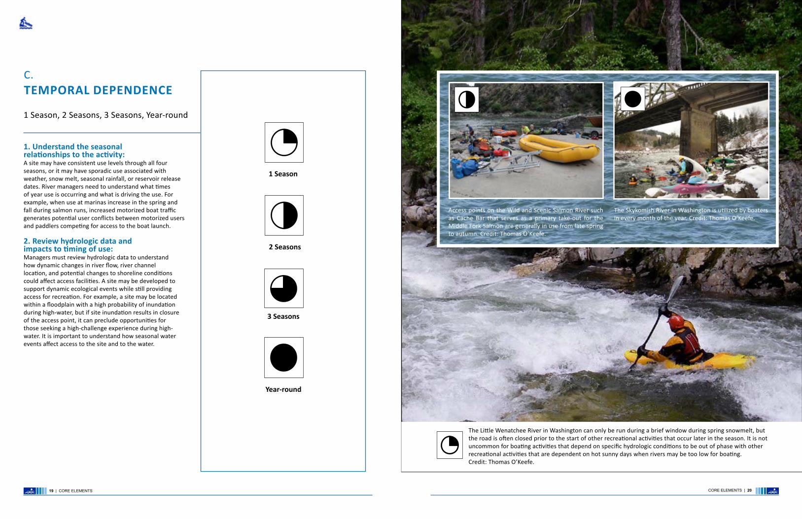
1. Understand the seasonal relationships to the activity:A site may have consistent use levels through all four seasons, or it may have sporadic use associated with weather, snow melt, seasonal rainfall, or reservoir release dates. River managers need to understand what times of year use is occurring and what is driving the use. For example, when use at marinas increase in the spring and fall during salmon runs, increased motorized boat traffic generates potential user conflicts between motorized users and paddlers competing for access to the boat launch.
2. Review hydrologic data and impacts to timing of use:Managers must review hydrologic data to understand how dynamic changes in river flow, river channel location, and potential changes to shoreline conditions could affect access facilities. A site may be developed to support dynamic ecological events while still providing access for recreation. For example, a site may be located within a floodplain with a high probability of inundation during high-water, but if site inundation results in closure of the access point, it can preclude opportunities for those seeking a high-challenge experience during high-water. It is important to understand how seasonal water events affect access to the site and to the water.
The Skykomish River in Washington is utilized by boaters in every month of the year. Credit: Thomas O’Keefe.
Access points on the Wild and Scenic Salmon River such as Cache Bar that serves as a primary take-out for the Middle Fork Salmon are generally in use from late spring to autumn. Credit: Thomas O’Keefe.
The Little Wenatchee River in Washington can only be run during a brief window during spring snowmelt, but the road is often closed prior to the start of other recreational activities that occur later in the season. It is not uncommon for boating activities that depend on specific hydrologic conditions to be out of phase with other recreational activities that are dependent on hot sunny days when rivers may be too low for boating. Credit: Thomas O’Keefe.
C.TEMPORAL DEPENDENCE
1 Season, 2 Seasons, 3 Seasons, Year-round
1 Season
2 Seasons
3 Seasons
Year-round
19 | CORE ELEMENTS CORE ELEMENTS | 20
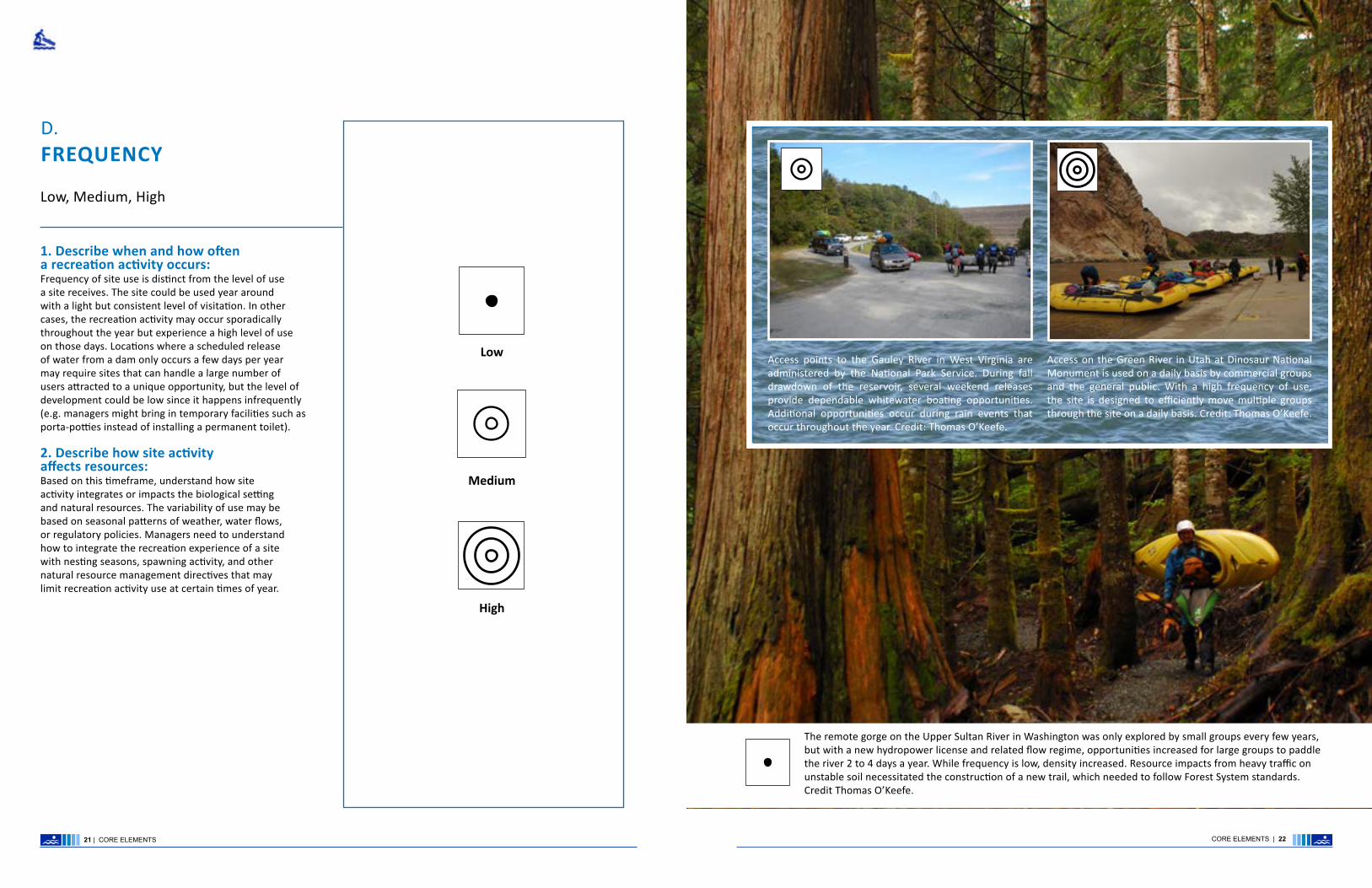
1. Describe when and how often a recreation activity occurs:Frequency of site use is distinct from the level of use a site receives. The site could be used year around with a light but consistent level of visitation. In other cases, the recreation activity may occur sporadically throughout the year but experience a high level of use on those days. Locations where a scheduled release of water from a dam only occurs a few days per year may require sites that can handle a large number of users attracted to a unique opportunity, but the level of development could be low since it happens infrequently (e.g. managers might bring in temporary facilities such as porta-potties instead of installing a permanent toilet). 2. Describe how site activity affects resources: Based on this timeframe, understand how site activity integrates or impacts the biological setting and natural resources. The variability of use may be based on seasonal patterns of weather, water flows, or regulatory policies. Managers need to understand how to integrate the recreation experience of a site with nesting seasons, spawning activity, and other natural resource management directives that may limit recreation activity use at certain times of year.
Access on the Green River in Utah at Dinosaur National Monument is used on a daily basis by commercial groups and the general public. With a high frequency of use, the site is designed to efficiently move multiple groups through the site on a daily basis. Credit: Thomas O’Keefe.
Access points to the Gauley River in West Virginia are administered by the National Park Service. During fall drawdown of the reservoir, several weekend releases provide dependable whitewater boating opportunities. Additional opportunities occur during rain events that occur throughout the year. Credit: Thomas O’Keefe.
The remote gorge on the Upper Sultan River in Washington was only explored by small groups every few years, but with a new hydropower license and related flow regime, opportunities increased for large groups to paddle the river 2 to 4 days a year. While frequency is low, density increased. Resource impacts from heavy traffic on unstable soil necessitated the construction of a new trail, which needed to follow Forest System standards. Credit Thomas O’Keefe.
D.FREQUENCY
Low, Medium, High
Medium
Low
High
21 | CORE ELEMENTS CORE ELEMENTS | 22

E.DENSITY
Low, Medium, High
1. Determine the density or level of use and spatial constraints:The physical organization of a site sets the stage for how users engage with the site. Understanding how many individuals will use a site along with the site’s spatial constraints will help deterimine appropriate facilities. Once level of use is determined, managers need to determine the spatial constraints and how the physical makeup of the site affects the opportunities. There should be appropriate space for parking and storage, distance between parking and the launch facility, and area for staging and launching boats. A lack of available space may lead to congestion and a lower quality visitor experience.
Low
Medium
High
The Sauk Wild and Scenic River in Washington is a popular day trip for outfitters and the general public with a density of use that is quite variable. Density fluctuates depending on the water level and weather. While the access can become congested during periods of optimal flows and good weather in late spring, density of use is generally low to moderate. Credit: Thomas O’Keefe.
With eight launches per day and high use density for a small physical footprint, the Boundary Creek Launch on the Wild and Scenic Middle Fork Salmon in Idaho can become very congested. In general, the system works because groups preparing for a week-long trip arrive the day before their launch. Groups wait their turn and rig boats in sequence, but it can take several hours for eight groups to all make it through the launch area. This arrangement would be unacceptable for a day-use scenario. Credit: Thomas O’Keefe.
Robe Canyon on the Stillaguamish River in Washington State has a high frequency of use with paddlers on the run nearly every day during the winter and spring paddling seasons but a low density of use given the difficulty of this class V run. Paddlers have made arrangements with local land owners for parking and access to the river. Such an arrangement would not be feasible if density of use was high. Credit: Sean Lee.
23 | CORE ELEMENTS CORE ELEMENTS | 24

1. Identify the top uses and potential conflicts:Any one site can support multiple uses depending on where it is located within the system and the temporal scale in which activities occur. Identifying who the users are, when they recreate, and the types of facilities needed to support their experience while protecting the setting is important. For example, a site used for boater access may also serve as a day-use site for families desiring contact access to the water.
Understanding the type of equipment primary users utilize and the requirements for transporting it to the site is also critical. For example, access needs for fully loaded rafts about to set out on a multi-day river trip are different from those for kayakers out on a day trip. Managers should include a process to consider how the distance from vehicle access to shoreline as well as the space needed for staging and launch preparation may differ among activities (e.g., kayakers can more easily carry their boats than rafters, who typically want to back a trailer as close to the river’s edge as possible).
2. Identify the challenge level:Challenge level is a component of the recreational experience for river runners, sea kayakers, canoers, and play boaters and may change depending on the time of the year and the character of the river system.
River Challenge Classes I, II, III, IV, V Rivers are rated on a class I-V scale of whitewater difficulty and provide users with a guide to assess the challenge associated with their chosen recreation activity. A site may provide access to an intermediate level experience at certain times of the year and an advanced level experience at other times of the year such as during snowmelt or after heavy rains. It is important for managers to understand the dynamic condition of the river system, where one is recreating and address the challenge levels and expectations of the river experience.
Heavily-polluted waterways like the Duwamish River in Seattle are being cleaned up. This opens the door for new recreation opportunities–including paddlesports–creating new demand for access. Credit: Thomas O’Keefe.
Kayaking Canoeing
Sailing
PaddleBoarding
Swimming
Fishing
Wildlife Viewing
Photography
While canoes and other paddlecraft are used for recreational enjoyment, they are also a traditional means of transportation on waterways. It is important to consider traditional and cultural uses of waterways during planning efforts. Credit: Thomas O’Keefe.
Merced River Recreation Area is near the entrance to Yosemite National Park, and provides overflow or alternative camping for park visitors, as well as a beautiful setting for river enthusiasts. Paddlers enjoy the river with spring flows but later in the season, the river is a destination for swimming and water play. Understanding how recreational use changes with season and water level is an important consideration in developing river access. Credit: David Greenwood.
Accessibility
Rafting
25 | CORE ELEMENTS CORE ELEMENTS | 26
F.USE TYPE AND CHALLENGE LEVEL
Recreation Activities and Skill Levels

G. MANAGEMENT
1. Identify management needs and challenges:Understanding management needs and identifying resources to implement them is a critical component in determining physical layout of a site. A manager may consider developing a site that has several management challenges with the primary project objective to address those challenges. For example, a dispersed recreation site along a river that is being used as a boater access, fishing spot, and dispersed camping area may have resource degradation and waste management issues. Careful planning can be used to address these management challenges and direct users to areas where their desired activity can be more effectively managed.
2. Identify resources for operations and maintenance:Planners need to have an understanding of long-term resources that are available for management. A hydropower operator who has license requirements for their project to provide public access may have a 50 year commitment to provide access and the revenue from hydropower operations to support it. A federal agency subject to annual fluctuations in federal appropriations will need to consider this uncertainty when making site design decisions. The following should be evaluated to identify resources and opportunities:
• Agency staff and financial resources for site operations and maintenance
• Ability to partner with stakeholder groups to adopt sites and support operations and maintenance
• Commitment to site monitoring to assess conditions and any issues requiring attention
TRIBALGOVERNMENT
FEDERAL GOVERNMENT
STATEGOVERNMENT
COUNTYGOVERNMENT
CITYGOVERNMENT
LOCAL JURISDICTION
ADVOCACY / STAKEHOLDER GROUP
The White Mountain Apache Tribe manages access to the Salt River in Arizona. Camping is available at primary access sites which also provide staging and launch areas for day trips and multi-day river trips. Credit: Thomas O’Keefe.
Paddlers launching at the base of Hoover Dam are escorted to the launch area by an approved canoe livery service. Those preparing for a trip through the Black Canyon of the Colorado along the Nevada-Arizona border only have a few minutes to launch due to security concerns and management restrictions on public access near the dam. Credit: Thomas O’Keefe.
The Headworks Run on the Green River in western Washington is a popular instructional reach, but the city utility was interested in restricting access due to security concerns associated with a municipal water intake facility. These restrictions could have resulted in a loss of access to features on the run that were desirable for instruction and training. In response, the utility constructed a boater access facility within the security perimeter for the watershed, and boaters check in at the security gate to access the river. Credit: Thomas O’Keefe.
CITY GOVERNMENT
FEDERAL GOVERNMENT
TRIBAL GOVERNMENT
27 | CORE ELEMENTS CORE ELEMENTS | 28

STEPS TO IMPLEMENTING THE RIVER ACCESS PLANNING GUIDE
The River Access Planning Guide details a step-by-step process for systematic information-gathering to define the core elements, plan, communicate, design, and monitor, while allowing the flexibility to consider unique river access needs. The document is organized around the following steps:
STEP 1: Assess and Summarize Existing Conditions STEP 2: Identify Desired Access STEP 3: Define Desired Recreation Setting Characteristics STEP 4: Evaluate Site Options and Select a Preferred Site(s) STEP 5: Assess Facility Design, Constructability, and Project Implementation STEP 6: Conduct Site Monitoring
The document is structured to give context and rationale for each of the steps, as well as specific direction for implementation. “Tips and Tasks” are denoted by the following symbols:
This symbol indicates TIPS for implementing the River Access Planning Guide.
This symbol indicates TASKS for each step of the River Access Planning Guide process.
To support mapping and other visual communication, icons are used to identify each of the attributes considered in river access planning and design.
STEPS TO IMPLEMENTING THE RIVER ACCESS PLANNING GUIDE
STEPS TO IMPLEMENTING THE RIVER ACCESS PLANNING GUIDE: INTRODUCTION | 30

Step 1 establishes a baseline by defining the project area and documenting the applicable management framework, current recreation use, and trends in recreational use and resource condition.
Collection and review of existing conditions is an essential first step toward understanding recreation use, setting, and experiences, which can then inform thinking around potential new access that addresses changing demands, impacts on resource conditions, and new recreation opportunities.
The outcome of Step 1 is clear documentation and illustration of baseline information that can be used to communicate with stakeholders and make informed planning decisions.
STEP ONE
Step 1 is initiated by the planning lead, who works with resource managers to gather relevant information to support the River Access Planning Guide process. The goal is to assemble baseline information efficiently so the planning team may work with a common baseline to engage stakeholders in Step 2.
TIPS
ASSESS AND SUMARIZE EXISTING CONDITIONS
STEP ONE
• What type of river system is the project located in (confined channel, sinuous channel, lake, alluvial reach, estuary)?
• What are the geomorphic and physical attributes and processes that could impact an access point including hydrologic character of the project area?
• Does the project focus on a single point-of-entry or a collection of access points along a river corridor?
Clearly define the project area.
TASKS
• What is the land ownership in the project area?
• What agency policies, regulations, or management direction exist regarding recreation setting, natural, cultural, and scenic resources, and/or visitor use?
• Are any unique features of the project area (i.e., cultural, recreation, ecological) identified in applicable planning documents?
• Are specific management goals and objectives associated with the project area?
A clear understanding of applicable regulations and/or management standards within your project area is key to the Guide. Regulations can pertain to recreation, resource management, development standards, and/or regulatory directives that establish parameters for the planning process. This is particularly important when desired future conditions for recreation and natural resources may already be established (e.g., a Wild and Scenic River Comprehensive River Management Plan may include guidance on facility development, user capacity, and actions to protect and enhance river values). Management standards may also direct permitted uses and use levels that inform an understanding of the social setting.
Identify applicable regulations and management standards that could affect access decisions.
DESCRIBE REGULATORY AND MANAGEMENT FRAMEWORK
DEFINE PROJECT AREA
The North Ford of the American River is a popular river rafting spot with existing use by outfitters and individuals. Credit: Dusty Vaughn
STEPS TO IMPLEMENTING THE RIVER ACCESS PLANNING GUIDE: INTRODUCTION | 32STEPS TO IMPLEMENTING THE RIVER ACCESS PLANNING GUIDE: INTRODUCTION | 3231 | STEPS TO IMPLEMENTING THE RIVER ACCESS PLANNING GUIDE: STEP ONE
Establishing clear boundaries for the project area defines the spatial extent of the work. The project area can vary considerably depending on the plan for type of recreation uses and experiences. Likewise, recreation opportunities may vary based on location of the project area or changes in the river system, landscape setting, season, flow, or levels of recreation use. For this step, planners and designers should think broadly about the project area because subsequent steps will allow for more-detailed refinement of recreation access and desired experience in specific sites.

1. 2.
Seasonal UseEach river system offers a variety of water-based recreation opportunities. Therefore, it is important to be specific about the type of recreation use occurring as well as when and where it occurs. Recreation use may be consistent or sporadic through all four seasons—depending on weather, snow melt, seasonal rainfall, or reservoir release dates. For example, a river in Colorado during the peak of snowmelt may experience high use for a few months in the spring but very little use later in the summer. Use at a marina may increase during spring and fall salmon runs, leading to increased motorized boat traffic and potential user conflicts between motorized boaters and paddlers. High or low flows may create challenging conditions either throughout the year (when water levels fluctuate because of rainfall or water releases) or across several years (use during a high-water year may be very different than a low-water year). Regardless of the recreation activity, facilities should provide safe access and protect the integrity of the sites’ resources. Access may also be needed for safety personnel or equipment; consider where search and rescue operations can and do access the river.
Challenge Level“Challenge level,” is a term used to describe the difficulty experienced by river runners and is defined by the Class I-V International Scale of River Difficulty. Challenge level is one component of recreation experience and may change depending upon the time of year. A site that provides access to an intermediate-level experience at certain times of the year may change to an advanced-level experience during snowmelt or after heavy rains. Challenge level may vary along the length of a river system, with certain segments providing expert-level experiences, while others are more suited to beginner or intermediate-level use. When a river changes dramatically in character, the associated transition in challenge level can be an important consideration for providing access to desired experiences. Within the challenge level determination, it is also important to address safety concerns and expectations of the river experience. Facility design and location affect the ability for river runners to target their desired experience.
Local DependenceUse may rely on a site-specific feature or system characteristic. For example, anglers may seek out a specific fishing hole or kayakers a specific wave. Knowing location-specific features may help point to the most appropriate location for new trails or activity-specific facilities designed to best support these uses. It could also direct secondary (and potentially conflicting) uses away from a particular site. For example, the best fishing hole on the river might have a network of social trails that are currently being used by kayakers out of convenience. Alternatively, a boat ramp may be the only location along a long stretch of river where anglers can cast effectively. Understanding these activities and why users are attracted to a particular site is vital to understanding the flexibility that may exist to segregate or combine uses.
To plan for variation in use, understand the underlying factors driving patterns of use by asking questions such as:
• What is the current recreation experience?
• How does this seasonal use, challenge level, or locational dependence affect use type?
• How can this information guide decision-making for access improvement?
Identify active and passive recreational activities. Determine river access for launching watercraft e.g., kayaking, rafting, boating, canoeing, paddle boardingand/or general day-use activities supporting contact access to the water e.g., fishing, swimming, wildlife viewing, photography, wading.
Identify temporal dependence of recreation use as flow-dependent (F), season-dependent (S), and/or operations-dependent (O).
Map locations of features and associated activities. Note the type of feature and the associated use.e.g., a pool for fishing, wave for kayaking, hazard requiring a portage.
Identify challenge level based on whitewater difficulty level. e.g., Class I to V
Identify user groups.e.g., public, commercial outfitter, or traditional use.
Identify trends in visitor use or status of natural resources.
Identify issues related to site safety and security.
TIPSEnlist people who might have information on current recreation use. Survey or host focus groups with users, local clubs, and outfitters. Review permit data or other use statistics, conduct user counts, and engage river managers to help gather information. Think outside the box, reflect local demographics, and account for accessibility.
Consider whether the project areas focus solely on an access facility, or if project areas include roads and trails leading to the access. How does this affect the user experience?
STEP ONE
TASKS
STEP ONE
IDENTIFY CURRENT RECREATION USE
The Wild and Scenic Aniakchak River in Aniakchak National Monument and Preserve, Alaska is the least-visited site in the National Park Service system. Only a handful of boaters have ever experienced this place. Neither developed facilities nor trails are present, which is appropriate in a setting where the desired condition for boaters is a natural backcountry experience. Credit: Thomas O’Keefe.
STEPS TO IMPLEMENTING THE RIVER ACCESS PLANNING GUIDE: STEP ONE | 3433 | STEPS TO IMPLEMENTING THE RIVER ACCESS PLANNING GUIDE: STEP ONE

The River Access Planning Guide provides a process to understand the current recreation setting and how changes to access may support or influence the desired recreation experience.
Even if project areas are not on lands managed by a dedicated recreation program, it is important to use the underlying principles that define the recreation setting characteristics to better understand the recreation context of the project area and guide decision-making. Recreation setting characteristics categorize the physical, social, biological, and managerial attributes of the recreation setting.
TIPSEnsure decisions regarding future access consider the extent to which new access could alter those attributes through inappropriate design, inadequate planning for operations and management, or by facilitating increased use.
Scale project area based on size and complexity as determined by geographic extent, diversity of recreational and physical setting, and need for coordination among different land management agencies.
CLASSIFY CURRENTRECREATION SETTING
STEP ONE STEP ONE
The Sitkum River in Washington State provides a high-challenge opportunity that is accessible from an unpaved forest road. The physical setting is a deep gorge with intermittent forest road access, the social setting is a river that sees infrequent use by expert kayakers seeking a high-challenge opportunity at high flows, the biological setting is a pristine headwater stream, and the managerial setting is characterized by a limited need for facilities other than the forest road, which requires ongoing maintenance. Credit: Nathaniel Wilson.
The social recreation setting reflects the amount and type of contact between individuals and groups. It is a measure of opportunities for solitude versus larger group interactions.
To describe the physical setting, think about the degree of remoteness (i.e., what type of access currently exists) and the extent that existing recreation and access development influences landscape character (i.e. visibility of development or percent coverage).
The managerial setting describes the level of site administration and management activities necessary to achieve desired recreation setting. For example, if visitor use levels are managed by special-use permits, the managerial setting may reflect the need for staff to monitor for permits at take-outs.
Identify access routes to existing facilities (remoteness) based on road or trail type.
Evaluate the existing physical recreation setting area as: Natural, Enhanced, or Constructed.
TASKS
Evaluate the existing social recreation setting by type of activities and their frequency of use and density, challenges, and hazards.
Evaluate the existing managerial recreation setting by assessing the existing operational and maintenance commitments.
The river access on the Payette River in Banks, Idaho is in a front-country area, and has a large paved parking area and boat ramp that serve thousands of river users during the busy summer season. Located at the confluence of two rivers, the site serves as the take-out for two river runs and the put-in for a third. With a high density of use by boaters and commercial outfitters, highly-developed facilities are appropriate and necessary to efficiently move people on and off the river. Credit: Thomas O’Keefe.
35 | STEPS TO IMPLEMENTING THE RIVER ACCESS PLANNING GUIDE: STEP ONE STEPS TO IMPLEMENTING THE RIVER ACCESS PLANNING GUIDE: STEP ONE | 36

STEP ONE STEP ONE
The River Access Planning Guide also considers existing trends in ecological integrity in the vicinity of the access facility by classifying the resource setting. This element highlights the potential effects of existing access locations on sensitive biological or cultural resources.
Evaluate the project area for sensitive resources: Classify based on the presence/absence of sensitive resources.
TASKS
It is important to determine how existing access sites accommodate current recreation types and/or current amount of use. Evaluation of each existing access facility in the project area should be based on its functionality within the context of user conflict, resource degradation, and setting inconsistencies.
• Facilities are appropriately scaled based on theexisting recreational activities.
• Facilities support multiple uses and varied visitorexperiences.
• Facilities enhance quality of the recreationexperience for diverse user groups.
• Facility design reduces user conflicts.
• Cultural and natural resource features and valuesare protected.
• Access site is appropriately located in relationshipto the river function and geomorphology.
• User safety of access site is considered relative toexperience level.
Assess functionality of current access facilities based on the following criteria:
TASKS
Rafts are a popular mode of transport on the South Fork Payette River in Idaho, and a raft slide is facility amenity necessary to enhance safety, prevent bank erosion and support a quality visitor experience. Credit: Thomas O’Keefe.
DESCRIBE RESOURCE TRENDS ASSESS FUNCTIONALITY
37 | STEPS TO IMPLEMENTING THE RIVER ACCESS PLANNING GUIDE: STEP ONE STEPS TO IMPLEMENTING THE RIVER ACCESS PLANNING GUIDE: STEP ONE | 38
River corridors are often areas with sensitive biological and cultural resources. Assessing important spawning reaches for fish or areas with cultural artifacts is an important step in describing resource trends and defining the setting. Credit: Thomas O’Keefe.
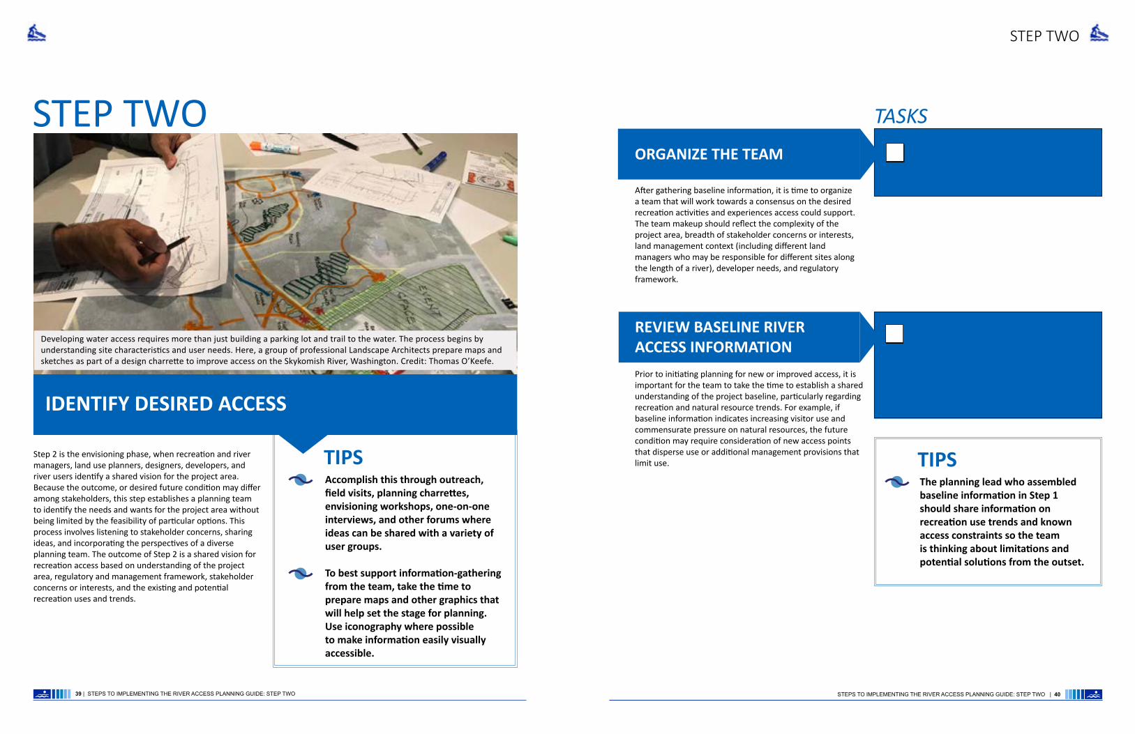
Step 2 is the envisioning phase, when recreation and river managers, land use planners, designers, developers, and river users identify a shared vision for the project area. Because the outcome, or desired future condition may differ among stakeholders, this step establishes a planning team to identify the needs and wants for the project area without being limited by the feasibility of particular options. This process involves listening to stakeholder concerns, sharing ideas, and incorporating the perspectives of a diverse planning team. The outcome of Step 2 is a shared vision for recreation access based on understanding of the project area, regulatory and management framework, stakeholder concerns or interests, and the existing and potential recreation uses and trends.
STEP TWO
Accomplish this through outreach, field visits, planning charrettes, envisioning workshops, one-on-one interviews, and other forums where ideas can be shared with a variety of user groups.
To best support information-gathering from the team, take the time to prepare maps and other graphics that will help set the stage for planning. Use iconography where possible to make information easily visually accessible.
TIPS
IDENTIFY DESIRED ACCESSPrior to initiating planning for new or improved access, it is important for the team to take the time to establish a shared understanding of the project baseline, particularly regarding recreation and natural resource trends. For example, if baseline information indicates increasing visitor use and commensurate pressure on natural resources, the future condition may require consideration of new access points that disperse use or additional management provisions that limit use.
Through interactive work sessions, share maps and information of the project area with the planning team. Begin identifying specific access needs for participants and the constituents they represent.
Organize the team and be sure to have varied expertise and perspective represented in the group.
TASKS
REVIEW BASELINE RIVERACCESS INFORMATION
ORGANIZE THE TEAM
The planning lead who assembled baseline information in Step 1 should share information on recreation use trends and known access constraints so the team is thinking about limitations and potential solutions from the outset.
TIPS
STEP TWO
39 | STEPS TO IMPLEMENTING THE RIVER ACCESS PLANNING GUIDE: STEP TWO STEPS TO IMPLEMENTING THE RIVER ACCESS PLANNING GUIDE: STEP TWO | 40
Developing water access requires more than just building a parking lot and trail to the water. The process begins by understanding site characteristics and user needs. Here, a group of professional Landscape Architects prepare maps and sketches as part of a design charrette to improve access on the Skykomish River, Washington. Credit: Thomas O’Keefe.
After gathering baseline information, it is time to organize a team that will work towards a consensus on the desired recreation activities and experiences access could support. The team makeup should reflect the complexity of the project area, breadth of stakeholder concerns or interests, land management context (including different land managers who may be responsible for different sites along the length of a river), developer needs, and regulatory framework.
STEP TWO STEP TWO
IDENTIFY AND DESCRIBETARGET RECREATION USES TIPS
Identify target recreation opportunities that a new or improved access and launch facility would support. Classify these opportunities by recreation use and opportunities. While Step 1 summarizes existing conditions, Step 2 is where the planning team comes together to think about new or improved access.
IDENTIFY AND DESCRIBETARGET RECREATION EXPERIENCES
Example statements are provided below:
“This boat launch should accommodate large groups and commercial outfitters preparing for a multi-day float. Amenities should include vault toilets, potable water, and sufficient parking to support private vehicle shuttle. The site would require intermittent facilities management and permit monitoring.”
“This take-out/day-use facility should provide separate areas to support these different recreational uses: the take out should provide a paved ramp, staging areas, SCAT machine, vault toilets, garbage receptacles, and sufficient parking to support vehicle shuttles. The site would require regular facilities management from May-October and permit monitoring. The day-use areas should be physically and visually separated from the take-out area. Facilities, such as picnic tables or benches, should be subordinate to the natural setting. Paths or ADA-accessible walkways should lead to water to best support fishing or waterplay.”
The take-out on the Wild and Scenic Rogue River meets the physical, social, biological, and managerial themes described above. Several groups a day use the river and a need exists for infrastructure to handle the use levels. Boater education along with facility operations and maintenance require a greater investment in management. Credit: Thomas O’Keefe.
41 | STEPS TO IMPLEMENTING THE RIVER ACCESS PLANNING GUIDE: STEP TWO STEPS TO IMPLEMENTING THE RIVER ACCESS PLANNING GUIDE: STEP TWO | 42
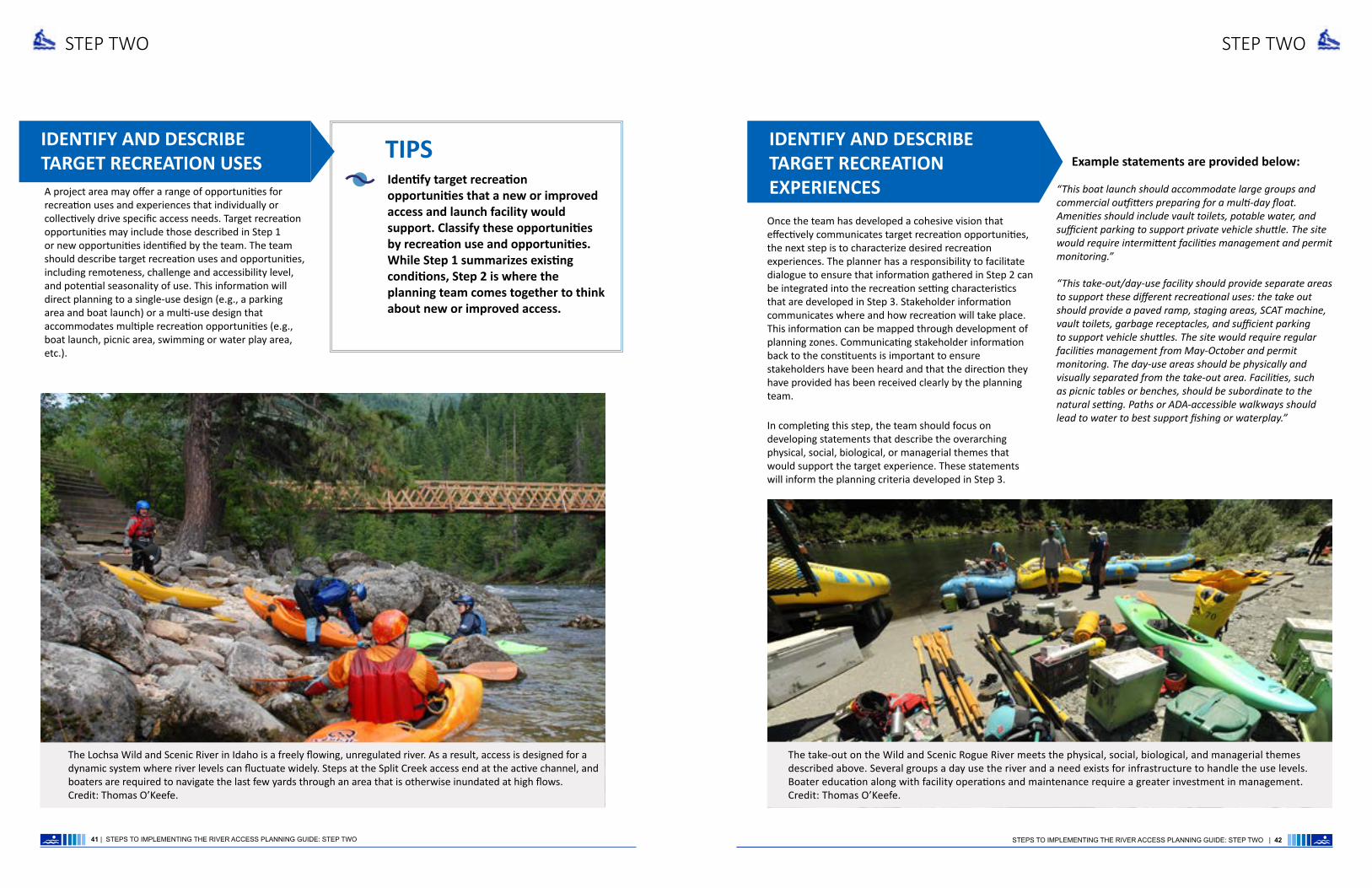
A project area may offer a range of opportunities for recreation uses and experiences that individually or collectively drive specific access needs. Target recreation opportunities may include those described in Step 1 or new opportunities identified by the team. The team should describe target recreation uses and opportunities, including remoteness, challenge and accessibility level, and potential seasonality of use. This information will direct planning to a single-use design (e.g., a parking area and boat launch) or a multi-use design that accommodates multiple recreation opportunities (e.g., boat launch, picnic area, swimming or water play area, etc.).
Once the team has developed a cohesive vision that effectively communicates target recreation opportunities, the next step is to characterize desired recreation experiences. The planner has a responsibility to facilitate dialogue to ensure that information gathered in Step 2 can be integrated into the recreation setting characteristics that are developed in Step 3. Stakeholder information communicates where and how recreation will take place. This information can be mapped through development of planning zones. Communicating stakeholder information back to the constituents is important to ensure stakeholders have been heard and that the direction they have provided has been received clearly by the planning team.
In completing this step, the team should focus on developing statements that describe the overarching physical, social, biological, or managerial themes that would support the target experience. These statements will inform the planning criteria developed in Step 3.
The Lochsa Wild and Scenic River in Idaho is a freely flowing, unregulated river. As a result, access is designed for a dynamic system where river levels can fluctuate widely. Steps at the Split Creek access end at the active channel, and boaters are required to navigate the last few yards through an area that is otherwise inundated at high flows. Credit: Thomas O’Keefe.
STEP THREE
By answering the following questions, recreation setting characteristics help determine how river access can support desired recreational experiences:
• What level of infrastructure is needed? [Physical]
• What level of visitor use should be provided for? [Social]
• What types of sensitive resources need to be considered? [Biological]
• What level of management would be required, and how does that level affect operational costs? [Managerial]
DEFINE DESIRED RECREATION SETTING CHARACTERISTICS
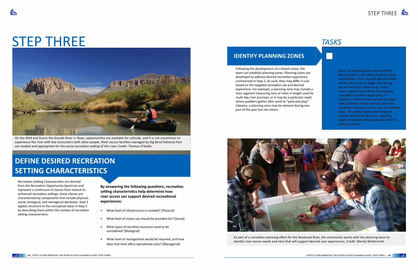
On the Wild and Scenic Rio Grande River in Texas, opportunities are available for solitude, and it is not uncommon to experience the river with few encounters with other people. River access facilities managed by Big Bend National Park are modest and appropriate for the social recreation setting of this river. Credit: Thomas O’Keefe.
STEP THREE
TASKS
IDENTIFY PLANNING ZONES
43 | STEPS TO IMPLEMENTING THE RIVER ACCESS PLANNING GUIDE: STEP THREE STEPS TO IMPLEMENTING THE RIVER ACCESS PLANNING GUIDE: STEP THREE | 44
As part of a recreation planning effort for the Nooksack River, the community works with the planning team to identify river access needs and sites that will support desired user experiences. Credit: Wendy McDermott.
Recreation Setting Characteristics are derived from the Recreation Opportunity Spectrum and represent a continuum of classes from natural to enhanced recreation settings; these classes are characterized by components that include physical, social, biological, and managerial attributes. Step 3 applies structure to the conceptual ideas in Step 2 by describing them within the context of recreation setting characteristics.
Following the development of a shared vision, the team can establish planning zones. Planning zones are developed to address desired recreation experience summarized in Step 2. As such, they may differ in size based on the targeted recreation use and desired experience. For example, a planning zone may include a river segment measuring tens of miles in length used for multi-day river journeys, or it may be a particular rapid where paddlers gather after work to “park-and-play.” Likewise, a planning zone may be relevant during one part of the year but not others.
Once the planning team has identified these locations, delineate planning zones around them. This step will identify which access sites focus on single uses during certain seasons or flows (e.g., a play area or wave) versus those that support a broader recreation experience. In addition to features that attract particular uses, planners should consider sites that represent hazards to avoid, such as lowhead dams. This added spatial and temporal context will inform decisions regarding target recreation setting characteristics for each access site
Chart or map access needs based on the type of facility needed to support uses and experiences.

STEP THREESTEP THREE
DESCRIBE ACCESS PLANNING COMPONENTS
TASKS
Which individual uses require access facilities?
Where would the facilities be located?
What type of access facilities are needed to support individual uses?
What use level is the system or site expected to accommodate; therefore, what is the desired scale of the facility?
What is the frequency of use? Consider the difference between a site that sees daily use vs. a site that only sees use a few days a year (e.g. during a scheduled release from a dam).
How will the facilities be designed to anticipate the scale and desired uses at the site?
What type of site amenities (e.g., turn-arounds, launches, restrooms, accessible features, cleaning stations, informational kiosks) are required for target recreation uses?
Would new or enhanced roads or trails be required to accommodate any access facility described above? If so, would this alter the recreation setting of that location or segment?
What site locations might facilitate barrier-free access or use of universal design elements?
In looking at the river processes and geomorphology, where are good locations for river access? What natural processes or man-made effects (e.g., tailwater flows) may affect the river access site?
The following questions can be used as a guide to placement of new access facilities:
Planning for a desired social setting is integral to an access facility functioning well. This is especially true in cases where multiple uses occur at a single location. The planning team needs to consider how new or modified access locations identified above influence the social setting of the access location, particularly in the context of conflicting uses or mobilizing larger groups from a launch point. For example, a primary project goal could be to develop a launch site that serves a busy commercial rafting operation that is also popular for general day-use and contact access. In this case, day-use activities may need to be separated from the commercial launch site to mitigate potential user conflicts and maintain specific recreation settings and experiences.
Consider the social setting and desired conditions for level of use, visitor interaction, group size, or potential for solitary experience based on the assessment in Step 1.
TASKS
The biological setting of the project area could influence planning and design for new or improved access based on existing or desired trends in the integrity of the resource. The planning team needs to consider how the location of facilities and/or potential changes in visitor use may degrade important resources.
• How would a new or improved access support the desired social recreation setting?
• What issues could arise related to carrying capacity, staging and circulation, and potentially conflicting uses?
• Would new or improved access alter the social setting?
It is acceptable at this stage to plan around resource degradation at a broad scale, because site-specific evaluations will be considered in more detail in Step 4.
TIPS
Backcountry adventures like a hike into the Swan River in Montana take place in a natural setting. Boater needs on the trail may be closely aligned with those of other users of the trail but could require greater clearance of overhead branches. Credit: Kevin Colburn.
PHYSICALBIOLOGICAL
SOCIAL
45 | STEPS TO IMPLEMENTING THE RIVER ACCESS PLANNING GUIDE: STEP THREE STEPS TO IMPLEMENTING THE RIVER ACCESS PLANNING GUIDE: STEP THREE | 46
This step maps out the ideas generated in Step 1 to ensure that access is designed to support desired recreation setting characteristics and related outcomes. For this exercise, the planning team should revisit existing characteristics identified in Step 1 and consider if specific uses, trends, and opportunities are consistent with those characteristics. If they are not, the team should first, consider how modifying access would play a role in changing recreation setting characteristics and second, determine whether a change is acceptable to land managers and stakeholders.
Consider existing roads or trails, and the extent to which remoteness attributes identified in Step 1 need to be maintained.
Consider the presence, distribution, and relationship of sensitive resources in the project area to existing or new access locations. Adjust access locations or managerial constraints (see below) accordingly to account for resource protection
Using baseline information developed in Step 1, and stakeholder input from Step 2, and planning zone maps developed in Step 3, identify and map potential new or modified access locations.

The planning team needs to consider the level of management required to support and maintain new or improved access facilities for the desired recreation experience, to support user needs, and to protect resource integrity.
Consider the management level necessary to achieve and maintain access facilities, targeted social setting, accessibility, and necessary natural, cultural, and scenic resource protection. In some cases, this could mean adjusting the level of management; a site could be designed to reduce the level of management (e.g., dispersed camping could be eliminated), or a site could come with new amenities that require a higher level of management (e.g., new restroom facilities).
TASKS
STEP THREESTEP THREE
This stage results in the creation of a master plan for site selection and design that responds to the initial questions in this step (step 3). This is accomplished by organizing information on access requirements and recreation setting characteristics to proceed to site evaluation (step 4). Planners should understand whether a site will serve primarily as a launch point for river runners, or if it serves a broader suite of day-use experiences (e.g., a picnic site, trailhead, access for scenic vistas).
Summarize access needs and planning direction in map format.
TASKSESTABLISH A PLANNING DIRECTION
The Forest Service manages the Horseshoe Bend access on Washington’s North Fork Nooksack River, a put-in for a Class III run used by the public and commercial outfitters. Once boaters are on the water, they pass the Forest Service boundary, after which, no formal access for take-out exists. This site illustrates a common challenge for river runners where different land managers have authority over the put-in and take-out. A potential take-out is available on state land, but with no other state recreation sites in the area, resources to manage it are unavailable. Rivers often flow through different jurisdictions, and planning often requires collaboration with managers representing these different jurisdictions. Credit: Thomas O’Keefe.
MANAGERIAL
47 | STEPS TO IMPLEMENTING THE RIVER ACCESS PLANNING GUIDE: STEP THREE STEPS TO IMPLEMENTING THE RIVER ACCESS PLANNING GUIDE: STEP THREE | 48
An access site on the North Fork Nooksack River primarily serves as a picnic area but users of all ages take advantage of a stairway that fits with the natural setting to access the river bank. Credit: Thomas O’Keefe.

STEP FOUR
Step 4 is a process for site evaluation and selection that features a balance among the following:
• Site Characteristics [physical, geomorphological]
• Descriptions of proposed amenities and facilities to support user activities
• Physical Site Constraints
• Design Considerations
STEP FOUR
Summarize site options in map format. Illustrate trade-offs pertaining to recreation experience, setting, and development constraints.
TIPS
EVALUATE SITE OPTIONS AND SELECT A PREFERRED SITE(S)
Bald Rock Canyon on the Middle Fork Feather Wild and Scenic River offers a sense of solitude, and is a high-challenge trip. Facilities are minimal, and kayakers carry lightweight overnight gear in their kayaks. Credit: Eric Petlock.
Consider the following:
TASKS
• Do recreation setting characteristics for each access site support the desired condition?
• What physical constraints exist at each access location?
• Do physical site limitations restrict the ability to separate uses?
• Are there known sensitive resources in the target access location?
• Can the project avoid impacts to these resources or mitigate through design solutions?
• Do site constraints (topography, surface materials, etc.) and budget allow for the design of barrier-free access or universal accessibility? If not, how is this issue addressed?
• Which sites best work with the naturally-occurring or human-induced river processes and geomorphology of the river?
49 | STEPS TO IMPLEMENTING THE RIVER ACCESS PLANNING GUIDE: STEP FOUR STEPS TO IMPLEMENTING THE RIVER ACCESS PLANNING GUIDE: STEP FOUR | 50
The outcome is a determination of whether access construction supports the desired recreation experiences within the larger recreation setting.
Canoeists on the Namekagon Wild and Scenic River enjoy family trips with brimful canoes and expect easy access to facilities. Many boaters car–camp and plan day trips to paddle different sections of the river over a weekend. Credit: Thomas O’Keefe.

River visitors consider many factors when choosing where to go, including the safety and security of the access area; the types of amenities offered (e.g., defined parking, maps or interpretive information, availability of drinking water, toilet, picnic tables, and trails); the distance from the parking to the water access; the presence and location of the restrooms; and the specific river condition or character of the water body. A diversity of shoreline conditions created by fast-moving whitewater, slowly meandering rivers, lakes, or tidally-influenced estuaries require a variety of design approaches to meet visitors need and recreational interests.
STEP FIVE
Summarize site options in map format. Illustrate trade-offs pertaining to recreation experience, setting, and development constraints.
TIPS
ASSESS FACILITY DESIGN, CONSTRUCTABILITY,AND PROJECT IMPLEMENTATION
Depending on the level of use, design approaches must consider site size, site amenities, life cycle of materials used, proposed recreation activities, and the potential to integrate or separate activities.
Identify development levels approaching the river and the facility needs for access related to the specific types of experiences (Natural, Enhanced, Constructed).
Describe specific cultural and natural resources to be protected and/or enhanced at the site.
TASKS
STEP FIVE
51 | STEPS TO IMPLEMENTING THE RIVER ACCESS PLANNING GUIDE: STEP FIVE STEPS TO IMPLEMENTING THE RIVER ACCESS PLANNING GUIDE: STEP FIVE | 52
Green River State Park (Utah) is an example of a hardened boat ramp used for launching multi-day trips on the Green River. The site also includes a developed campground with shower facilities.

STEP FIVE STEP FIVE
• The design process will vary depending on the scale, complexity, location, and budget of the project.
• Regardless of these factors, designers must address the spatial considerations associated with the project goals (i.e., configuration of the project area), actions that respond to the objectives (e.g., surface material durable enough to handle 200 users per day), the criteria and issues associated with the design (project sideboards), the site amenities, and how each amenity is spatially represented on the site.
COMPONENTS OF THE DESIGN PROCESS
To determine the level of design needed to guide a project, components are separated into the following stages:
• Concept design
• Site limitations
• Construction documentation, details, and specifications
• Constructability (includes construction feasibility, construction management, materials staging, and implementation of resource protection measures)
• Construction Period and Timing
CONCEPT DESIGN
Site limitations such as topography, land ownership, existing infrastructure, subgrade utilities, sensitive environmental and cultural resources, stockpiling/disposal constraints, and construction access influence constructability of the design.
Consider how existing topography influences the ability of equipment to access the site.
Develop a plan for how to use the byproducts from site clearing to support the construction efforts. Identify areas for staging and stockpiling materials that do not impact sensitive resources.
Coordinate construction access with neighboring landowners and agencies. Identifying necessary permissions, permits, and agreements associated with access will help determine the size and amount of equipment that may enter the site to support the work.
TASKS
Construction documentation and specifications are developed after the conceptual design for a site is finalized and approved by key stakeholders and the client. Construction documentation represents the ”blue prints” consisting of technical details and specifications that are needed to support layout and construction of the physical site amenities.
CONSTRUCTIONDOCUMENTATION
SITE LIMITATIONS
STEPS TO IMPLEMENTING THE RIVER ACCESS PLANNING GUIDE: STEP
The concept design is a spatial representation of the on-site facilities and how their distribution and locations work to mitigate site issues and support desired user experiences. The conceptual design is a graphic representation of the design program (i.e. the design and associated management). The design program may be as simple as communicating the need for a small parking area, staging location, and graded beach for primary use by individuals launching their own boats or it may be a more extensive design program that includes more developed infrastructure and separated areas for day use, boat launch area, and commercial raft operations that are actively managed.
West Shore Day Use Area is a day-use recreation site, trailhead parking area, and designated hand launch area for paddlecraft users. Concept design illustrates the site program and spatial considerations. Credit: Jordan Secter.
West Shore Day Use Area construction drawings include plan drawings and renderings that show how site features are laid out on the site. The renderings communicate project objectives in the context of design specifications. Credit: Jordan Secter.

STEP FIVE STEP FIVE
Constructability refers to the technical and financial feasibility of an overall project design, including consideration of the construction approach and techniques. Construction issues can significantly influence both the feasibility and design of a river access project. The constructability of a site, along with the revegetation and protection of sensitive resources, is critical to the successful implementation of a design. Selection of construction methods is determined by affordability, availability of equipment, access to work sites, regulatory constraints, and the complexity of working within the constraints of site characteristics and features.
Facility design and constructability should reflect the desired outcomes communicated by the constituent groups and the ability of facility managers to design, afford, construct, manage, and maintain the site.
Ensure construction documentation, details, and specifications describe a comprehensive installation process as well as a recommended maintenance regime.
Layout drawings and design details need to describe the distribution and materials of the site amenities and facilities, whereas design details will describe how the features are to be constructed.
Specifications will communicate the parameters of the construction (e.g., how and where materials are to be staged and areas to be fenced and protected from construction impacts) and the parameters of materials (e.g., gravel, paving, concrete, stone, vault toilet, etc.).
TASKS
CONSTRUCTABILITY
Regulatory mandates intended to reduce impacts to critical habitat (e.g., salmonid migration and spawning) often determine timing of the project. This timing varies depending on the species present and location in a water body (e.g., headwater rivers, meandering rivers, or estuaries). After identifying a construction window for the project, factors such as river conditions (low-water conditions are often ideal for construction), precipitation, and revegetation considerations will determine the most appropriate time to begin construction and operate within the established work period.
CONSTRUCTION PERIODAND TIMING TIPS
Understanding seasonal variation of flows, dam release timing, and the potential drawdown of water may be helpful in determining appropriate timing for construction.
Develop appropriate revegetation and erosion control measures and identify specific equipment needed to work at the site.
Identify the time needed for post-construction activities. For example, revegetation efforts outside of the primary construction period may coincide with early-season rainfall and/or the commercial availability of plant materials.
Recent construction of access improvements to the St. Croix Wild and Scenic River. Credit: Thomas O’Keefe.
55 | STEPS TO IMPLEMENTING THE RIVER ACCESS PLANNING GUIDE: STEP FIVE STEPS TO IMPLEMENTING THE RIVER ACCESS PLANNING GUIDE: STEP FIVE | 56
The plan and section drawings communicate the route to the river and the type of access and facility (boat slide) necessary to safely transition from the top of the bank to the river shoreline. These design details are necessary to ensure site development proceeds in a manner that meets user needs while addressing potential resource impacts River. Credit: Jordan Secter

STEP SIX
Monitoring the desired condition and recreation setting of a site is integral in identifying what is and is not working once a site is developed. Monitoring results can inform changes or improvements to a site over time. Site monitoring can function in three ways:
• Post-Occupancy Evaluation
• Visitor Use
• Experience Monitoring.
STEP SIX
CONDUCT SITE MONITORING
Post-Occupancy Evaluation ensures that the design was constructed as specified in the construction plans and the integrity of sites resources were protected as directed in the plans.
POST OCCUPANCY EVALUATION
Check that punch list items are completed as directed by the plans or as communicated through contracts.
Review documentation that sensitive resources were protected from construction-related impacts. If impacts are identified, provide a plan for enhancement and/or restoration.
Final review of materials and facilities to ensure that all facilities were installed per manufacturer specifications and/or design details. Confirm that construction activities resulted in no damage to facilities or resources.
TASKS
The second level of monitoring addresses “limits of acceptable change” for both recreation use and desired recreation setting characteristics. Monitoring for limits of acceptable change include specific site indicators. Specific indicators will vary depending on the recreation use, setting characteristics, and facility or amenities at each access site.
Evaluate the types of recreation uses and determine if observed uses are consistent with planned uses. Is a new use occurring that was not previously considered? Are new river access sites attractive places for dispersed camping that was not occurring before?
Determine if recreation setting characteristics are consistent with planned opportunities and desired outcomes. Consider physical, social, managerial, and biological setting characteristics.
Evaluate facility condition and function. Are recreation facilities and amenities functioning in a manner that supports desired recreation use and protects resources?
VISITOR USE ANDEXPERIENCE MONITORING
57 | STEPS TO IMPLEMENTING THE RIVER ACCESS PLANNING GUIDE: STEP SIX STEPS TO IMPLEMENTING THE RIVER ACCESS PLANNING GUIDE: STEP SIX | 58
On the Middle Fork Snoqualmie Wild and Scenic River (Washington), a recent paving project formalized access sites along the river; however, one of the sites was inadequately sized for its intended current use. The result is that users are unloading boats and gear in the road. The facility is not effectively functioning in a manner that supports the desired recreation use. Credit: Thomas O’Keefe

Across the country, each river has a unique set of desired recreational experiences and river access site characteristics. The need for updated river access planning, design, and management tools is also driven by the regional diversity that exists among river user culture, visitor use levels, land ownership, and agency policies. The principles outlined in this guide will help the river manager, the site designer, and the river access advocate understand the desired outcomes that a visitor would like to see accommodated, and establish a process for delivering those outcomes while also maintaining natural resources. The information provided in this guide is intended to provide advice and direction for those involved in river access development, and can help facilitate conversation among agency staff, nonprofits, decision makers, contractors, volunteers, and the public at large. These guidelines will exist as both a printed book and an online document that can be referenced during all phases of river access planning, design, and management.
CONCLUSION
59 | STEPS TO IMPLEMENTING THE RIVER ACCESS PLANNING GUIDE: CONCLUSION STEPS TO IMPLEMENTING THE RIVER ACCESS PLANNING GUIDE: CONCLUSION | 60
A day of high use tubing on the Comal River in Texas illustrates both the popularity of floating rivers and the potential for impact on the resource. Credit: Mike Dussere.

Case Study Elochoman Slough Marina, Washington
Case Study: Elochoman Slough Marina, Washington | Appendix | A | 6261 | Appendix | A |
LOCAL JURISDICTION
River Access Planning Guide
Appendix A: Case Studies by Jordan Secter
- Elochoman Slough Marina, Washington- Clackamas River, Oregon- Bridge at Elwha River, Washington
System: Estuary/Riverine
Temporal: 2-4 Season
Setting: Constructed
Frequency: Low - High
Density: Low - High
Management/Ownership
Location: Cathlamet WashingtonSite: Elochoman Marina at the Wahkiakum Port District 1Context: Rural Marina at River Mile 38 Geomorphology: Estuarine and Riverine Recreation Use: Active and passive: paddlesports boat access, motorized boat access, Seasonal camping, river viewing, fishing and crabbing

ASTORIA
PAC
IFIC
OC
EAN
VANCOUVER
WASHINGTON STATE
OREGON STATE
ELOCHOMAN SLOUGH MARINA CATHLAMET, WASHINGTON
MOUNT ST. HELENS
Mile 144
Mile 0
Mile 38
Mile 102
Mile 75
The City of Cathlamet is located at River Mile 38 along higway 14 in southwest Washington. Views of the existing boat ramp, parking, and dock system at the Elochoman Slough Marina at the City of Cathlamet in southwestern Washington. Credit: Port of Cathlamet.
View of Cathlamet waterfront from the Columbia river near Puget Island. Credit: Jordan Secter.
Introduction This case study applies the River Access Planning Guide to a marina within an estuarine setting. Port managers are faced with adapting their facilities to support a broader set of uses and needs. Applying the framework will help managers choose the correct type of facility to support paddlesports in a manner that enhances the user experience.
ContextThe Elochoman Slough Marina is located on the Columbia River at river mile 38 in Cathlamet, Washington and is a key location on the Lower Columbia Water Trail. It is located near a small car ferry that connects Westport, Oregon and Puget Island, Washington, which links Cathlamet via the Julia Butler Hansen Bridge. These routes provide the only vehicle access between Oregon and Washington between Astoria-Megler Bridge at River Mile 10 and the Lewis and Clark Bridge connecting Rainier, Oregon and Longview, Washington at River Mile 68.
The Elochoman Marina provides a wide range of paddling opportunities and support services for motorized users and paddlesports enthusiasts on the Lower Columbia River. Specifically, the site has become a trailhead destination for paddlers recreating on the Lower Columbia Water Trail serving as a starting point, termination point, or midway resupply point.
Less experienced paddlers use Elochoman Slough, behind Hunting Islands, as an access point for a more protected paddling experience that avoids the high
winds and shipping traffic encountered in the main channel. More experienced paddlers explore the main channel with destinations that include paddling upstream to Little Cape Horn, across the river to explore Puget Island’s farmhouse-dotted sloughs, or downstream to experience the Julia Butler Hansen Refuge for the Columbian White-tailed Deer and Lewis and Clark National Wildlife Refuge.
The islands of the Columbia River estuary, open vistas, and relatively low use levels result in a paddling experience through a natural setting that is not that much different from what Lewis and Clark would have encountered more than two centuries ago. The Lewis and Clark National Historic Trail and Lower Columbia Water Trail overlap on this section of river.
Case Study: Elochoman Slough Marina, Washington | Appendix | A | 6463 | Appendix | A | Case Study: Elochoman Slough Marina, Washington

Camping
Shared Parking
Brew Pub
MarinaBoat Slips
Cabins and Access road
Marina Office and Facilities
RV Camping
WA-4 W
Fueling Station
Boat Ramp
Marina access
Marina access
The Elochoman Slough Marina is a full-service marina that includes a boat fueling station, marina offices and facilities, along with RV camping, cabin rentals and, a boat launch. The marina is within walking distance from the town of Cathlamet, brew pubs, and grocery stores.
The Elochoman Slough Marina is a popular location for private and commercial motorized boats to launch in exploring the Lower Columbia. When the marina is busy, large groups can be difficult to accommodate within the existing marina layout. Credit: Port of Cathlamet.
Case Study: Elochoman Slough Marina, Washington | Appendix | A | 6665 | Appendix | A | Case Study: Elochoman Slough Marina, Washington
As paddlesports activity increases at the marina, the need to provide a launch site that will separate uses and reduce conflicts between motorized boats and kayaks at the boat ramp has increased. Separating the facilities will reduce user conflict and congestion while improving access and the overall user experience for those accessing the water trail. In addition, a launch area serving paddlers will increase boater safety and result in a more welcoming environment at the maria
Site analysis and existing conditionsThe marina is operated by the Wahkiakum Port District 1, a municipal corporation based in Cathlamet, Washington, and offers a wide range of services that include the following: restrooms, showers, laundry facilities, fuel service, a pump-
out station, dry-land camping, guest cabins, yurt camping, RV Parking, picnic areas, and a barbecue cooking area. The marina has a two-lane cement boat ramp, and provides monthly and transient moorage in more than 150 slips.
Commercial and recreational fishermen frequent the marina during fishing season and the marina is a traditional summer destination for yacht clubs, recreational motorized boaters and, paddlesports enthusiasts. It is central to the community of Cathlamet, adjacent to a waterfront community park, a short walk from a small brewpub, a five-minute walk to the services of downtown Cathlamet (hotel, bed and, breakfasts, grocery, restaurants, bars, art galleries, and shops).
Genesis of the ProjectThe Lower Columbia Estuary Partnership (Estuary Partnership), a bi-state, non-profit National Estuary Program developed and coordinates the Lower Columbia River Water Trail. Understanding the Elochoman Slough Marina’s importance and the challenges and opportunities associated with paddlers launching at the site is essencial to the visitor experience. The Estuary Partnership reached out to marina staff and key stakeholders to explore alternative boat launch options at the marina that would serve the paddling community.
In spring 2017, a comprehensive site review was conducted to assess opportunities to provide a standalone boat launch for kayaks. In doing
so the marina manager, a port commissioner, Columbia River Kayaking staff, Estuary Partnership staff, and a professional landscape architect walked the marina, explored opportunities and constraints, and discussed the need for, and the benefits of, a dedicated boat launch area to serve the paddlesports community.
Purpose and NeedThe Port of Cathlamet Commissioners recognize the need to provide a dedicated launch site for the paddlesports community at the marina.
Issues driving this need are an increase in paddlers using the marina and a recognition that facilities should reflect the spectrum of uses and the desired experience.

Setting: Constructed
System: Estuary/Riverine
Temporal: 2-4 Season
Setting: Constructed
Frequency: Low - High
Density: Low - High
Use Type and Challenge Level
Case Study: Elochoman Slough Marina, Washington | Appendix | A | 6867 | Appendix | A | Case Study: Elochoman Slough Marina, Washington
The two lane concrete boat ramp sits idle in the off season. Credit: Jordan Secter.
Port Managers have an interest in mitigating user conflicts at the boat ramp that result from shared use of a facility by users with different needs. Whether paddlers are out for the day or on an overnight journey, the Port recognizes that paddlers need more time to stage and load their boats. When they do this within the limited footprint of the existing boat ramp, the resulting congestion creates access issues for all users
When the Port recognized the need for a dedicated launch site for the paddlesports community, they also wanted to ensure that other Port facilities and activities were considered in selecting a site. Site alternatives are all within the developed setting of the marina, but once paddlers leave the marina the experience quickly transitions to the natural setting of the Lower Columbia River.
For paddlers, the transition from the developed environment to the natural setting is important for how paddlers experience their overall trip.
Site program priorities identified by paddlers for launch point development were:
• Short distance from parking and restrooms to the launch point
• Launch area separate from the concrete motorized boat launch
• The launch needed to have natural qualities and feel less developed within the broader developed setting of the marina
• Provide accessible access to the launch• Identify a clear path to paddle out of the
marina separate from the path of motorized boats
System: Estuary/RiverineThe marina is located at the outer edge of the Columbia River estuary. The river is tidally influenced and is connected to the ocean through a series of estuarine islands, slough and pastoral riverine side channels. The site is a short driving distance from the greater Portland metropolitan area and can be easily accessed as a day trip.
Setting: ConstructedThe marina is a constructed setting with a paved boat ramp, large paved parking area, port offices and storage buildings, and marina infrastructure. The Port is located in the heart of the town of Cathlamet and is within walking distance to grocery stores, restaurants, hotels, and pubs.
Temporal: 2-4 SeasonThe facilities at the marina are used throughout the year by both motorized boaters and paddlers. The marina is exceptionally busy during the spring and fall salmon runs. Summer weather attracts paddlers, while the more extreme winter weather tends to discourage use.
Frequency: Low - HighWhile use occurs throughout the year the frequency of use is moderate with high visitation during salmon runs, summer days with favorable weather, and during city celebrations and events.
Density: Low - HighMost use occurs around the boat ramp and within the large parking area adjacent to the the Port offices and bathrooms. The congestion of people and cars within the area around the boat ramp can block access for those trying to access the ramp and overnight users who wish to access the campground. This density also creates issues between different user groups trying to access the boat ramp to launch their watercraft.
Use Type and Challenge Level: Low -Medium - HighThis site is predominately used by sea kayakers. Those who sea kayak on the Lower Columbia tend to be highly experienced. Rapidly changing weather, cold water temperature, and boat traffic represent hazards that require a high level of experience and safety training. This site is unique however given that the marina provides access to a protected area behind islands that under certain conditions are suitable for less experienced paddlers. This area can also be used for commercial groups and instruction.
Framework Assessment

A
D
BC
The aerial site plan shows the four different sites selected by the Port Commissioners and local paddlers as possible locations for a kayak launch site. Site A represents opportunities to launch from a point near the fuel station, site B considers adapting a launch point at the existing boat ramp, site C represents an opportunity to access the water via the existing gangway and low-profile docks, and site D assesses options for improving access through shoreline enhancement and development of an access point at the northwest corner of the marina.
Case Study: Elochoman Slough Marina, Washington | Appendix | A | 7069 | Appendix | A | Case Study: Elochoman Slough Marina, Washington
Opportunities & ConstraintsIn order to address issues associated with the site, the review team evaluated four key areas as possibilities for a designated access point serving the paddlesports community that include the following locations:
A) Fueling station ramp and beachThe site is located at the southwest end of thepeninsula near the yurt camping and the fuelstation and two feasible river access locationsoffer opportunities at this site. A clearedarea just large enough for a van and trailerprovides space for a turnaround and drop offarea for boats. An existing trail and gangwaylead to the water.
A boat launch could be developed from the existing gangway near the fuel station or by developing a short path to a new facility at the tip of the peninsula. Issues associated with this site include a long distance from the parking area to the put in, development of a new day-use facility within the camping area, the need to provide a low profile float to accommodate paddlers, and an access location that would be adjacent to boat fueling and motorized boat activity.
Gravel turnaround near the end of the camping zone provides possible access to the water for paddlers. Credit: Jordan Secter.
Fueling station and dock located near the yurts and camping area. Credit: Jordan Secter.

B
B
B
B
C
C
The three lane concrete boat ramp separated into two lanes. Credit: Jordan SecterExisting gangway access to boat slips at along the north edge of the marina. Access to the gangway is from a paved road surface anchored by utility boxes, power poles and other infrastructure support marina activity. Credit: Jordan Secter
B) Existing boat ramp and vegetated bankThis shared launch point creates conflicts and safety issues between paddlers and motorized boaters. While the boat ramp can be quiet in the winter off-season when use levels are lower, long lines form on busy weekends during spring through fall resulting in congestion. Paddlers and motorized boaters have different needs for a launch point: paddlers need time to unload their boats from their vehicles, stage them near the water and, then pack their boats with gear for their trip, while motorized boaters use the boat ramp as a single drop-off point.
Waterway between vegetated bank and marina dock next to the existing boat ramp.
C) Access from the northeast gangway and floatAccess from the northeast gangway near the entry to the marina provides a potential area to develop an access point. From this site, paddlers would park in the existing two campsites and walk their boats down the angled gangway to the docks. Low profile docks would then be adapted to the existing floats and provide access to the water.
Issues associated with this site include limited capacity on the floats and insufficient space for paddlers and their boats. Larger groups such as commercially-guided trips that use the marina would find it challenging to stage trips. Additionally, the access out of the marina from this location is blocked by a second gangway that has insufficient clearance for boats to pass under at high tide.
Water levels at high tide showing opportunities to launch between the dock and the shoreline. Credit: Jordan Secter
Case Study: Elochoman Slough Marina, Washington | Appendix | A | 7271 | Appendix | A | Case Study: Elochoman Slough Marina, Washington

Site D: Proposed Site Plan Layout
D
D
Parking
Parking
Access platformKayak Storage Shed
Accessible Float
Overflow Parking
Travel Lane
Vehicle travel lane
Clear travel path out of the marina
Parking area along the northern access road provides entry to the marina dock system. Marina utilities are secured at the top of bank and run along the the base of the gangway to the docks.
Access road along the north side of the marina. A grassy emabankment slopes down to the tidal zone. Vehicle camping could be made viable along the north side of the road. Credit: Jordan Secter
This conceptual site plan addresses the Purpose and Need expressed by paddlers and port managers for a separated launch area that meets user needs and fits within the developed setting of the marina.
D) Embankment from the northwest cornerAn embankment along the shoreline adjacent to the northeast gangway has potential for development as an access for paddlers. The shoreline at this site could be modified and integrated with existing marina facilities to provide access for kayaks in an area of the marina that currently experiences low use. By locating the access facility to the north of the gangway paddlers would be separated from motorized boaters and have a protected route out of the marina that avoids motorized boat traffic.
This site is separated from the main circulation of the marina, providing paddlers with an experience that avoids conflicts with motorized users. Access along the shoreline offers opportunities for boat staging, parking, the addition of restrooms, and the possibility of a kayak storage shed.
Case Study: Elochoman Slough Marina, Washington | Appendix | A | 7473 | Appendix | A | Case Study: Elochoman Slough Marina, Washington
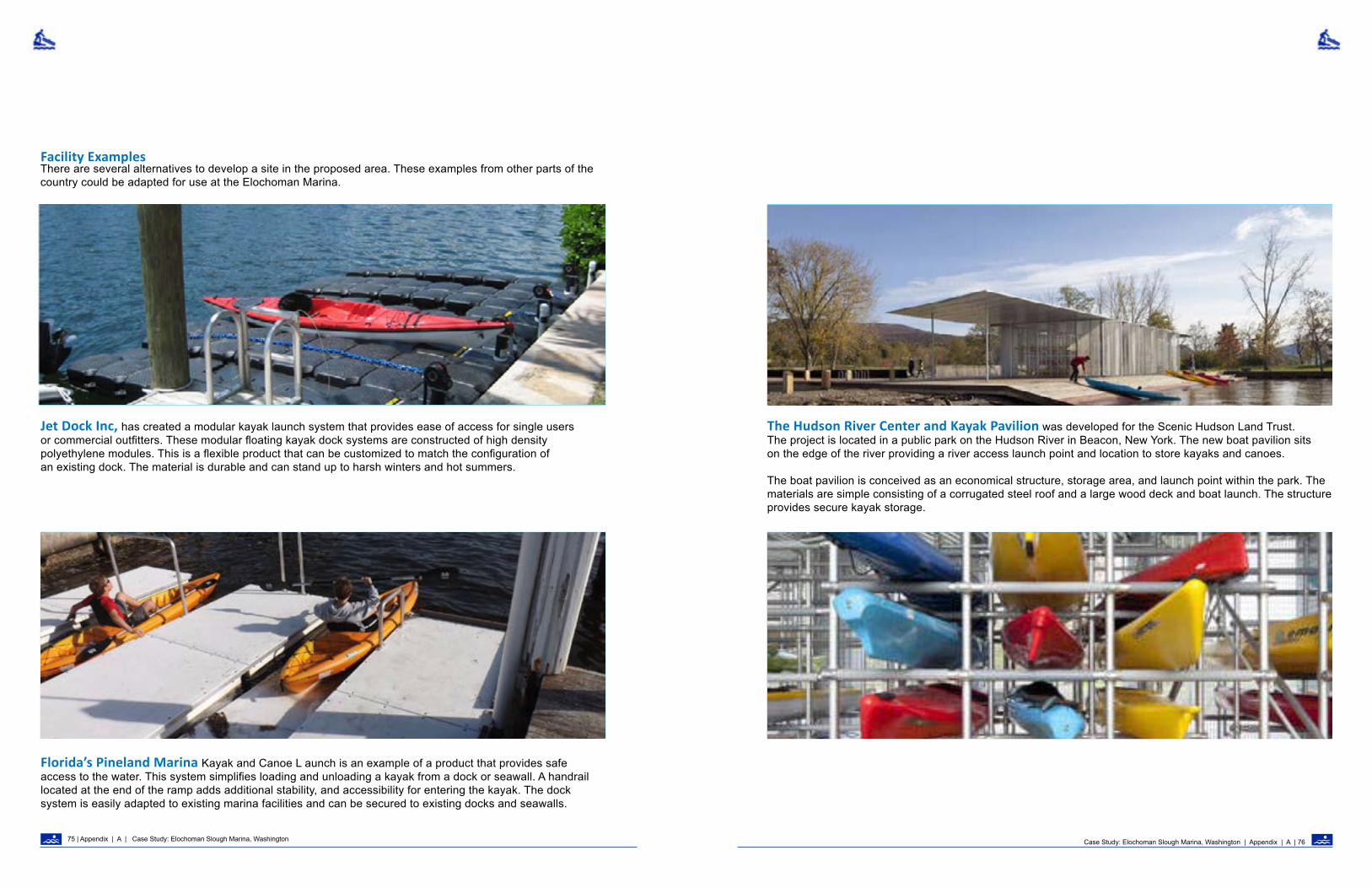
Facility ExamplesThere are several alternatives to develop a site in the proposed area. These examples from other parts of the country could be adapted for use at the Elochoman Marina.
Case Study: Elochoman Slough Marina, Washington | Appendix | A | 7675 | Appendix | A | Case Study: Elochoman Slough Marina, Washington
Jet Dock Inc, has created a modular kayak launch system that provides ease of access for single users or commercial outfitters. These modular floating kayak dock systems are constructed of high density polyethylene modules. This is a flexible product that can be customized to match the configuration of an existing dock. The material is durable and can stand up to harsh winters and hot summers.
The Hudson River Center and Kayak Pavilion was developed for the Scenic Hudson Land Trust. The project is located in a public park on the Hudson River in Beacon, New York. The new boat pavilion sits on the edge of the river providing a river access launch point and location to store kayaks and canoes.
The boat pavilion is conceived as an economical structure, storage area, and launch point within the park. The materials are simple consisting of a corrugated steel roof and a large wood deck and boat launch. The structure provides secure kayak storage.
Florida’s Pineland Marina Kayak and Canoe L aunch is an example of a product that provides safe access to the water. This system simplifies loading and unloading a kayak from a dock or seawall. A handrail located at the end of the ramp adds additional stability, and accessibility for entering the kayak. The dock system is easily adapted to existing marina facilities and can be secured to existing docks and seawalls.

Case Study: Clackamas River, Oregon | Appendix | A | 7877 | Appendix | A |
System: Estuary/Riverine
Temporal: 2-4 Season
Setting: Natural/ Enhanced
Location: Clackamas River, OregonSite: Moore Creek, Hole in the Wall, and Sandstone BridgeContext: Half to full day whitewater river experience one hour from the City of PortlandGeomorphology: Boulder/step poolRecreation Use: Active and passive: whitewater rafting and kayaking, river viewing, fly fishing, and swimming.
Frequency: Low - Medium
Density: Low - High
FEDERAL PARTNERSHIPUTILITY
Management/Ownership
Case Study Clackamas River, Oregon

The Clackamas River is popular for rafting with many user-created river access points. Mile Post 41, was evaluated based on its location within the river system, opportunity to access the river from the shoreline, the potential to managed day use recreation site to mitigate for existing dispersed recreation activities at the site.
The Clackamas River is popular for rafting with both members of the public and commercial outfitters. The Upper Clackamas Whitewater Festival draws hundreds of competitors and spectators to the river each year in May. Credit: Thomas O’Keefe.
Case Study: Clackamas River, Oregon | Appendix | A | 8079 | Appendix | A | Case Study: Clackamas River, Oregon
Introduction This case study applies the River Access Planning Guide to three access sites that were developed on the federally-designated Clackamas Wild and Scenic River administered by the Forest Service. Hydropower facilities associated with the Clackamas River Hydroelectric Project are located upstream and downstream of a segment of the river that is partially regulated and popular for whitewater paddling. Among the protection, mitigation, and enhancement measures for recreation, the license order for the hydropower project included requirements for three developed river access points along the river. Although the river is popular with both the general boating public and commercial outfitters, and located within an hour’s drive of the greater Portland, Oregon metropolitan area, access was poorly managed and the river was accessed by one developed site and a number of dispersed sites that had evolved over time. Portland General Electric, the operator of the hydroelectric facilities, worked with the boating community, local outfitters, and the Mount Hood National Forest to evaluate several user-created dispersed access sites along the river. Three sites were selected as appropriate for a higher level of development and were constructed.
ContextA total of nine sites that were used by the paddling community were evaluated for potential development as part of this project. The majority of these sites were unmanaged dispersed sites with no sanitation, open areas along the road with room for parking, and informal social trails to the river. Signage and wayfinding information was absent making it difficult to locate preferred access points. Although the river was popular, many paddlers arriving for the first time had difficulty identifying the most appropriate access points for their skill level, style of trip, and water level. While trips down the entire 15 mile reach were desirable during high spring flows, the upper reaches become too shallow later in the summer making an intermediate access option desirable. Many of the sites presented challenges for rafters with narrow trails or long carries. One site at Fish Creek had been formalized several years ago with a raft slide but it was in the middle of a reach that was desirable for whitewater rafters.

HOLE IN THE WALL ACCESS
ROARING RIVER RAPID (III)
THE NARROWS (III)
POWERHOUSE RAPID (III)THREE LYNX POWERHOSE
SANDSTONE BRIDGE ACCESS
HOLE IN THE WALL RAPID (III)
River access was located at the base of an existing gravel beach that provided easy entry to the river. Visitors often encountered activities such as dispersed camping and other non-sanctioned uses at the site that made it unattractive for day use. Credit: Jordan Secter.
River access prior to project development was challenging as it was difficult to walk over large boulders and down the steep slope to the river. Site users found it extremely cumbersome to carry boats and gear over the uneven surface. Credit: Jordan Secter.
This map shows potential access points that were evaluated during the site review stage and rapids (features) on the river that were of significance for whitewater paddlers.
Case Study: Clackamas River, Oregon | Appendix | A | 8281 | Appendix | A | Case Study: Clackamas River, Oregon
FISH CREEK RAPID (III)
CARTER BRIDGE ACCESS
ROCK AND ROLL RAPID(II-III) BIG EDDY ACCESS
BOBS HOLE (III)TOILET BOWL (III+)
CARTER BRIDGE RAPID (III+)
Genesis of the ProjectThe Clackamas River is a Wild and Scenic River with recreational values that were in need of enhancement. The issuance of a new hydropower license by the Federal Energy Regulatory Commission also provided the resources to invest in upgraded recreational facilities along the river. With approximately a dozen
dispersed sites in use along the river and with increasing use levels, river managers and river users had a joint interest in formalizing and improving river access to improve the quality of the user experience and address resource degradation issues.
MEMALOOSE ACCESS
NORTH FORK RESERVOIR
MOORE CREEK ACCESS

One of the sites considered for further development was Bob’s Hole, which is adjacent to a popular play feature and at the end of the class III whitewater. The opportunity was for an access at the transition between class III and class II whitewater. A major constraint was the inability to provide parking between the river and road requiring site users to cross the highway. Credit: Thomas O’Keefe.
Paddlers and commercial whitewater outfitters have used the boat slide at Fish Creek as a primary access point. The evaluation of the user experience along the river determined that the Fish Creek location was not an ideal location due to limited parking at the site, that also serves as a trailhead, and additional class III whitewater immediately upstream. Credit: Thomas O’Keefe.
Case Study: Clackamas River, Oregon | Appendix | A | 8483| Appendix | A | Case Study: Clackamas River, Oregon
Purpose and Need Flowing off the slopes of Mt. Hood, the Clackamas River provides some of the most accessible intermediate and beginner whitewater to the greater Portland area with a long season that includes both winter rains and spring snowmelt. The long season and consistent flows in years of good snowpack extend into early summer making this a dependable river for commercial rafting.
The community interest was for improvements to river access that would enhance the overall quality of the user experience for the general boating public including rafters, kayakers, canoeists, and stand up paddleboarders as well as recreational outfitters. Since the river is popular for day trips and as an after-work option for boaters from the greater Portland area, it was important to have access that was able to handle large crowds during busy spring weekends.
Access had to be designed to serve a wide range of rafts (from large 16’ oar frames, to paddle rafts, to smaller two-person rafts). Many rafters row a solo oar frame and needed the ability to easily transport the raft from the parking area (or loading zone) to the river. It was desirable to have options for kayakers that would provide segregated launch areas and access routes to reduce user conflicts. Sites had to be designed to handle commercial groups with space for trip orientation and safety talks.
Site Analysis and Existing ConditionsProblems with the existing sites were a lack of sanitation, facilities that were largely user-created over time and insufficient for the level of use, and a lack of signage and wayfinding information to direct users to the appropriate sites for the desired user experience. While social trails to the water were acceptable for kayakers they were generally too narrow and inadequate for rafters. Since the sites were largely dispersed sites with no active management, they were also used for dispersed camping leading to waste issues and social conflicts. The river provides habitat for federally-listed salmon and enhancing the salmon run was also a goal of the project with several measures in the hydropower license designed to make progress towards this goal. Given this sensitivity, clearing riparian vegetation was undesirable, and in fact actions to enhance riparian condition were of interest to river managers and river users. Additionally, access projects had to be coordinated with side channel restoration projects.
Opportunities and Constraints Nine sites were evaluated along the river for potential enhancement. Opportunities were based on availability of adequate parking and space for a toilet between the highway and the river (three of the sites required crossing the road between the parking and the river).
Hydrology of the river was also a consideration with a desire to have an access near the start and end of the class III whitewater and an intermediate access point that could serve as a put-in when flows drop in summer. Existing dispersed sites were desirable to avoid clearing riparian vegetation at new sites along the river. Sites with a stable channel, a good beach and eddy for staging or pulling out, and short distances from parking to the river were also desirable.
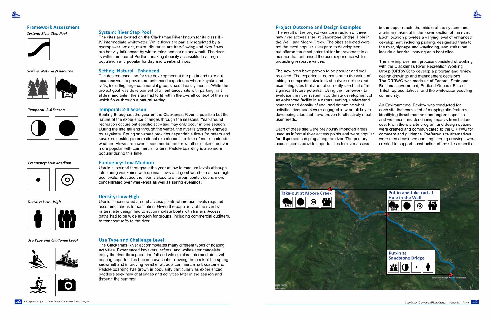
System: River Step Pool
Temporal: 2-4 Season
Setting: Natural /Enhanced
Frequency: Low -Medium
Density: Low - High
Use Type and Challenge Level
Put-in at Sandstone Bridge
Take-out at Moore Creek Put-in and take-out at Hole in the Wall
System: River Step PoolThe sites are located on the Clackamas River known for its class III-IV intermediate whitewater. While flows are partially regulated by a hydropower project, major tributaries are free-flowing and river flows are heavily influenced by winter rains and spring snowmelt. The river is within an hour of Portland making it easily accessible to a large population and popular for day and weekend trips.
Setting: Natural - EnhancedThe desired condition for site development at the put in and take out locations was to provide an enhanced experience where kayaks and rafts, including large commercial groups, could easily launch. While the project goal was development of an enhanced site with parking, raft slides, and toilet, the sites had to fit within the overall context of the river which flows through a natural setting.
Temporal: 2-4 SeasonBoating throughout the year on the Clackamas River is possible but the nature of the experience changes through the seasons. Year-around recreation occurs but specific activities may only occur in one season. During the late fall and through the winter, the river is typically enjoyed by kayakers. Spring snowmelt provides dependable flows for rafters and kayakers desiring a recreational experience in a time of more moderate weather. Flows are lower in summer but better weather makes the river more popular with commercial rafters. Paddle boarding is also more popular during this time.
Frequency: Low-MediumUse is sustained throughout the year at low to medium levels although late spring weekends with optimal flows and good weather can see high use levels. Because the river is close to an urban center, use is more concentrated over weekends as well as spring evenings.
Density: Low-HighUse is concentrated around access points where use levels required accommodations for sanitation. Given the popularity of the river by rafters, site design had to accommodate boats with trailers. Access paths had to be wide enough for groups, including commercial outfitters, to transport rafts to the river.
Use Type and Challenge Level: The Clackamas River accommodates many different types of boating activities. Experienced kayakers, rafters, and whitewater canoeists enjoy the river throughout the fall and winter rains. Intermediate level boating opportunities become available following the peak of the spring snowmelt and improving weather attracts commercial raft customers. Paddle boarding has grown in popularity particularly as experienced paddlers seek new challenges and activities later in the season and through the summer.
Project Outcome and Design Examples The result of the project was construction of three new river access sites at Sandstone Bridge, Hole in the Wall, and Moore Creek. The sites selected were not the most popular sites prior to development, but offered the most potential for improvement in a manner that enhanced the user experience while protecting resource values.
The new sites have proven to be popular and well received. The experience demonstrates the value of taking a comprehensive look at a river corridor and examining sites that are not currently used but offer significant future potential. Using the framework to evaluate the river system, coordinate development of an enhanced facility in a natural setting, understand seasons and density of use, and determine what activities river users were engaged in were all key to developing sites that have proven to effectively meet user needs.
Each of these site were previously impacted areas used as informal river access points and were popular for dispersed camping along the river. The primary access points provide opportunities for river access
in the upper reach, the middle of the system, and a primary take out in the lower section of the river. Each location provides a varying level of enhanced development including parking, designated trails to the river, signage and wayfinding, and stairs that include a handrail serving as a boat slide.
The site improvement process consisted of working with the Clackamas River Recreation Working Group (CRRWG) to develop a program and review design drawings and management decisions. The CRRWG was made up of Federal, State and Regional government, Portland General Electric, Tribal representatives, and the whitewater paddling community.
An Environmental Review was conducted for each site that consisted of mapping site features, identifying threatened and endangered species and wetlands, and describing impacts from historic use. From there a site program and design options were created and communicated to the CRRWG for comment and guidance. Preferred site alternatives were then developed and engineering drawings were created to support construction of the sites amenities.
Case Study: Clackamas River, Oregon | Appendix | A | 8685 | Appendix | A | Case Study: Clackamas River, Oregon
Framework Assessment

The Sandstone Bridge site was used as an informal river access point and popular dispersed camping area. With the lack of management and formality to the site, garbage and debris were scattered throughout the site and riparian vegetation was used as fuel for fires. Access for boaters was down a steep slope from the parking area which made carrying and staging gear difficult. Credit: Jordan Secter.
The result of the design was improvement and formalization of the parking areas along the road, construction of stairs and rail slide, installation of information kiosks, and clean up of the site from dispersed camping. Portland General Electric and the Forest Service are actively managing the site as the primary river access point in the upper reach of the river. Credit: Jordan Secter.
The Sandstone Bridge site was evaluated for opportunities to provide improvement that focused on river access, improved parking, and discouraged dispersed camping. Design drawings were created to show how opportunities would fit the site. A committee made up of representatives from Portland General Electric, the Forest Service, and the paddling community provided input on the design and the appropriate level of development at the site.
Case Study: Clackamas River, Oregon | Appendix | A | 8887 | Appendix | A | Case Study: Clackamas River, Oregon
Sandstone BridgeSandstone Bridge was the farthest site upstream on the section of the Clackamas River identified for access improvements. The existing site had minimal parking and steep access off the road to the river and inadequate space for a vehicle turn around area. A defining feature of this site is the hydrology and channel bed morphology that combine to create conditions unsuitable for river rafting and kayaking when river flows are lower. As a result, this site is viable for river rafting and kayaking for a more limited season.
Due to the more limited seasonal use of this site compared to others downstream, the site is less developed and includes basic roadside parking suitable for smaller groups. Staging area for the general public and commercial trips is available but
more limited than downstream sites that are more heavily used. A colored concrete staircase stamped to resemble basalt with raft slide rails provides a smooth transition from the parking to the river.
Signage and wayfinding kiosks along the road and the river shoreline orient river users and clearly identify the site as a boat launch and not a dispersed campsite. Site development along the shoreline of the river was left in a natural condition and natural materials such as logs and boulders were used to define the edges of the site to concentrate visitor use in the beach area and avoid impacts to surrounding riparian vegetation.

Corrugated Metal Pipe
Boulder Barrier
Right of Way
SIGN: Rocks
User Created Trail
User Created River Access Trail
Transmission Tower
Cable Car
Trail To Cable CarDispersed Campsite
Trail To DispersedCampground
SIGN: PGE Water LevelMan Made Wood PileStream Restoration
Area
Dispersed Campsite
Boulder Barrier
Dirt Spur Road
To moredispersed campsites
by river
EXISTINGGRASS AREA
EXISTINGGRASS AREA
TREE CANOPY
TREE CANOPY
EXISTINGGRASS AREA
SITE ENTRY/EXIT LOCATION SITE ENTRY/EXIT LOCATION EXISTINGGRASS AREA
Drainage Stream
M A P L E G E N D
Forest Canopy
DispersedCampsiteGraveled Area
Dirt Spur Road
River
River CrossingCable N
Shoreline Trail
Internal Trail
Guardrail
Edge of Pavement
Edge of Water
Stream Side ChannelAverage 100 year flood
Transmission Line
Top of Bank
Sign
Reflector Post
Fire Pit
Boulder
M I L E P O S T 4 1 : E x i s t i n g c o n d i t i o n s
Prior to site improvement, Hole in the Wall was an exposed rocky site with no defined spatial organization. Small patches of grass were interrupted by a network of user-created roads and pathways through the site. Mature conifers and riparian vegetation surround the site. Credit: Jordan Secter.
Existing site conditions were mapped and the physical attributes were described in an environmental review. This documentation provided the base data to guide site development opportunities and communicated areas to protect and enhance resource values.
Case Study: Clackamas River, Oregon | Appendix | A | 9089 | Appendix | A | Case Study: Clackamas River, Oregon
Hole in the Wall at Mile Post 41Hole in the Wall is located in the middle section of the primary rafting and kayaking section of the Clackamas River. Prior to the start of the project, a large clearing under powerlines managed by Portland General Electric created an open area for parking, dispersed camping, and unmanaged river access. The site was primarily a large gravel area with user-created roads and a steep rutted path from the top of the bank to the river’s edge. Day-use recreation was popular at this location but user conflicts were common and dispersed camping created ongoing challenges for managers.
Long-term dispersed camping in the forested areas along the edges of the site was a major concern of the Forest Service. Initiating site improvement to support river access was supported by the Forest Service as a catalyst to address recreational use behavior that was creating ongoing site impacts and management challenges.
Before constuction, this site was identified as a desirable location for river runners to put-in when water levels in the upper section of the river were too low. A tributary immediately upstream of the site, and changes in river bed morphology result in conditions that support a longer season in the river reach immediately downstream of this site. Erosion of soils along the path to the water, exposed roots and large boulders made it very difficult to transport boats, equipment, and people down to the river. Overgrown vegetation along the shoreline made it difficult for people to gather and stage their gear and boats.
The plan drawings communicate the location of the route to the river on the site, the width of the path, and the placement of the stairs. The plan also identifies site attributes such as the high-water mark, the top of bank and proposed trailhead; all necessary for planning, design and construction of a safe route to the river.

The section drawings communicate the route to the river and the type of access and facility (boat slide) necessary to safely transition from the top of the bank to the river shoreline. These design details are necessary to ensure that the proposed feature is able to be constructed and that site development proceeds in a manner that meets user needs while addressing potential resource impacts.
Plan Drawing
Case Study: Clackamas River, Oregon | Appendix | A | 9291 | Appendix | A | Case Study: Clackamas River, Oregon
Rafters launching at Hole In The Wall, formally known as milepost 41. Site features include a boat slide and handrail system with a stamped-concrete staircase. The stair is designed to withstand high water flood events. Credit: Thomas O’Keefe.
Moore Creek was designed similar to Hole in the Wall with a defined parking area, information kiosks, restrooms, and a screened changing area. Since this site is primarily a take-out, a raft slide was not installed but a contoured path wide enough to walk rafts up from river to the parking area was constructed. Portland General Electric and the Forest Service are actively managing the site as a new primary access and take-out site and day use area for people wanting to enjoy the river. A short class II reach downstream of this site is used by paddleboarders and beginner kayakers.
Section Aa
Edge of Water
Beginning of Trail and Staircase
6.7%
3.3%
2%
2%
A a
Boat Rail Slide
3:1 Basalt stairs (5)
3:1 Basalt stairs (1)
2:1 Basalt stairs (10)TOS
BOS
12’ 6' 30’ 18’ 9.5’ 12’ 30’
TOE OF SLOPE

System: Estuary/Riverine
Temporal: 4 Season
Setting: Natural/ Enhanced
Location: Highway 101 on the Olympic Peninsula, WashingtonSite: Highway 101 Bridge crossing the Elwha River Context: Half to full-day whitewater river experienceGeomorphology: Boulder/step pool; river is recovering from dam removalRecreation Use: Active and passive; whitewater rafting and kayaking, and river viewing
Frequency: Low
Density: Low
Case Study: Elwha River Bridge Highway 101, Washignton | Appendix | A | 9493| Appendix | A | Case Study: Clackamas River, Oregon
STATE
Management/ Ownership
Case Study Elwha River Bridge Highway 101, Washington

Recreational paddlers have enjoyed the Elwha River within Olympic National Park for decades. Credit: Thomas O’Keefe. The map of the Elwha River shows the spatial relationships of access points to river features and historic locations within the system. The entire system has changed significantly with the removal of the dams. In particular, the channel bed and alluvial fan at the river’s mouth are dramatically different due to the increase in sediment transport. New recreational opportunities are also now available..
IntroductionThis case study applies the River Access Planning Guide to a highway bridge that is being reconstructed across the Elwha River. Bridge right-of-ways are important for access to waterways across the country. A poorly designed project can result in loss of access and missed opportunity, while a well-designed project can enhance the recreational user experience and address potential safety issues at the site.
The National Park Service completed removal of the Elwha Dam from the Elwha River in 2012, and removal of the upstream Glines Canyon Dam in 2014. Prior to dam removal, rafters and kayakers regularly enjoyed the river between the two dams, putting in below Glines Canyon Dam in Olympic National Park and taking-out at the top of the reservoir created by the Elwha Dam (Aldwell
Reservoir). Olympic Hot Springs road parallels the river and connects the two access points. The Highway 101 Elwha River Bridge crosses the river at the top of the former Aldwell Reservoir site, and historically, boaters took out at one of two locations immediately downstream of the bridge on the reservoir. These locations have been significantly altered since Elwha Dam has been removed and there currently is no suitable take-out for the run. The Washington Department of Transportation is planning to reconstruct the Highway 101 Bridge, and Washington State Law requires the agency to evaluate the feasibility of providing public waterway access any time a bridge is reconstructed. The bridge replacement provides an opportunity to consider the options for providing waterway access at this location.
ElwhaRiver Mouth
River Access Point
“That Dam Rapid“(IV+)
WDFW Boat Ramp (Historic)
Elwha Lodge (Historic)
Highway 101 Bridge
User-created River Access Site
Olympic National Park Boundary
Fisherman’s Bend Rapid (III)
Ledge Drop Rapid (IV)
Glines Canyon Dam Site View Point (Historic)
Highway
101
Case Study: Elwha River Bridge Highway 101, Washignton | Appendix | A | 9695 | Appendix | A | Case Study: Elwha River Bridge Highway 101, Washignton

After a century of use for hydropower production, Elwha Dam removal began in the fall of 2011 and was completed within six months. With removal of the dam the reservoir transitioned to a river environment dramatically changing public access for rafts and kayaks who historically used access points on the upper end of the reservoir as take-outs for river trips. Credit: Thomas O’Keefe.
The historic McDonald Bridge was constructed in 1926, but since removal of Elwha Dam was completed in 2012, the elevation of the river bed at the bridge site has lowered 14 feet. Since the bridge foundations are set on gravel, concern over the integrity of the bridge has prompted the Washington Department of Transportation to initiate an emergency project to rebuild the bridge. Credit: Thomas O’Keefe.
Case Study: Elwha River Bridge Highway 101, Washignton | Appendix | A | 9897 | Appendix | A | Case Study: Elwha River Bridge Highway 101, Washignton
Context Prior to the removal of Elwha Dam, the two historic access locations just downstream of the Highway 101 Bridge served as a take-out for river runners and provided general access for flatwater recreationists who boated on Aldwell Reservoir. The first location was at the historic Elwha River Resort, located immediately downstream of the Highway 101 Bridge on the east side of the river, and nestled in between Highway 101 and Aldwell Reservoir. Highway 101 parallels the east bank of the Elwha River/former Aldwell Reservoir and curves sharply to the west just before the bridge. The Resort was built in 1920, and in addition to a gas station and cabins, included a boat ramp and large gravel clearing that trucks pulling boats and travel trailers used, as did vehicles with rafters floating the river. The Resort also had dedicated parking for rafters, and overall was a central location for watersports in the region for many decades.
The Resort eventually fell into disrepair, and all of the buildings have since been removed. However, recreational boaters continued to use the boat ramp and former reservoir resort property as an
access point, including for a time after Elwha Dam was removed. The proposed new bridge alignment will pass through the former resort property. The second access on the reservoir was a Washington Department of Fish and Wildlife (WDFW) boat ramp located on the west bank of the reservoir 0.2 miles downstream of the Elwha River Bridge. Since Elwha Dam was removed, both sites are no longer feasible for providing access to the river due to the dramatic changes to geomorphology and vegetation in the area. At the WDFW access, the reservoir drained away from the boat ramp immediately after dam removal and vegetation has established on the reservoir bottom lands. At the historic resort property, the river channel eventually migrated away from the boat ramp. As of late 2017, boaters need to walk ¼ mile over debris jams spread out over former reservoir bottom lands, providing a challenge for kayakers and an impractical solution for canoers and rafters.
Genesis of the ProjectIn 2016, the Washington State legislature passed legislation requiring the Washington Department of Transportation to prepare a feasibility report on public access as part of the design and construction process for bridges across navigable waterways. This feasibility report “must include a description of the suitability for public use, implications associated with potential access, and the availability of alternate public access within a reasonable distance, if present.” (RCW 47.01.500 (3)). Additionally, “to the greatest extent practicable, when constructing a state highway project, including a major improvement project, the department must not adversely impact preexisting, lawful public access to a waterway.” (RCW 47.01.500 (2)). Reconstruction of the Highway 101 Bridge provides an opportunity to improve public access to the river at a site that has historically been used for public access to the waterway.
Purpose and Need Paddlesports enthusiasts have recognized the Elwha River as a destination for whitewater rafting, kayaking, and canoeing for decades. The segment from Glines Canyon to the Elwha River Bridge is a
Class II-III whitewater run that was popular before dam removal and continues to be a close-to-home recreation destination for paddlers living on the North Olympic Peninsula. It is one of the few whitewater runs on the Olympic Peninsula with sufficient flows for whitewater boating during the early part of summer when most other rivers in the region are too low for boating. Now that the two main locations for take-out access are no longer feasible, the whitewater boating community has an interest in improving this situation in conjunction with the construction of a new bridge across the Elwha. In addition to being the end of a popular Class II-III run, this location is important because there is a challenging Class IV rapid at the former Elwha Dam site. The area in the vicinity of the Elwha River Bridge offers the last practical place to provide a take-out prior to this major rapid. An access at the bridge also allows for an easy shuttle along Olympic Hot Springs Road.
In addition to providing access for boaters, visitors to the region have an interest in learning more about changes to the river following dam removal and seek an opportunity to experience the former reservoir bottom lands directly.

The view out across the former reservoir lands from the historic boat launch site at the Elwha River Resort. The active river channel has migrated away from this location. Credit: Thomas O’Keefe
Riprap stabilizes the riverbank next to the existing bridge. This location provides uneven access to the river. The size of the riprap material creates a barrier to access for all but the most agile individuals. Credit: Thomas O’Keefe
The existing site is clear of vegetation and used by Washington Department of Transportation as a staging area for materials. This site is at the centerline of the new highway and will link to the new bridge alignment. Credit: Thomas O’Keefe
The Elwha River Bridge was built in 1926 and the 3-span, 388-foot, concrete-arch bridge has served the community over 90 years. Alluvial transport of sediments and significant change in river bed morphology have resulted in a river that flows below the bridge foundations.
Case Study: Elwha River Bridge Highway 101, Washignton | Appendix | A | 10099 | Appendix | A | Case Study: Elwha River Bridge Highway 101, Washignton

The view of the river down stream from the existing highway 101 bridge shows the large cobbles and down woody debris being recruited into the river channel. This tranformation has pushed the mainstem of the river to the west side of the channel. Credit: Jordan Secter
System: River Step Pool
Temporal: 4 Season
Setting: Natural /Enahnced
Frequency: Low
Density: Low
System: River Step Pool This section of the Elwha River is known for Class II-III whitewater. The river is free-flowing and experiences high flows during rain-on-snow events in early fall. The river is within a 15 minute drive of Port Angeles, Washington with a population of approximately 20,000 and is the closest river run for the local paddling community. The river is approximately 2 hours travel time, including ferry crossing, from the greater Seattle area with a population of approximately 4 million.
Setting: Natural - EnhancedThe river flows through a natural setting. The site at the Elwha River bridge is appropriate for a low level of enhancement.
Temporal: 4 SeasonFlows on the Elwha are high enough to boat during the winter months and through the spring snowmelt. Flows are often too low to boat in late summer, however it is possible to boat the Elwha year-round depending on snowpack, which varies year to year. A commercial outfitter has operated on the river with a season from late spring to early summer. Frequency: LowUse is sustained throughout the year at low levels. Weekends are more popular but given the proximity to Port Angeles, weekday use by the local community is common too. Given the easy access to the river from the state highway, paddlers from the greater Seattle area often run the Elwha on trips to the Olympic Peninsula.
Density: Low Density of use is consistent but low. The river is rarely in use by more than one or two groups at a time. A commercial outfitter has guided trips that involved one to two boats no more than twice a day.
Use: Kayaking, Rafting, Canoeing, SightseeingThe river is used by kayakers, rafters, and canoers. While the general public predominantly uses the river, a commercial outfitter has operated on the river. The river is appropriate for intermediate paddlers with the skills and training to paddle Pacific Northwest rivers. Cold water and wood hazards make this a river that is inappropriate for beginner paddlers or tubers.
Use Level
Framework AssessmentOpportunities and ConstraintsFollowing dam removal, opportunities to provide river access for boaters have been limited. The historic access locations are impractical due to dramatic geomorphologic and vegetation changes. Additionally, there are limited alternate sites.
Kayakers sometimes take-out approximately 1.1 miles upstream of the Elwha River Bridge, however, this location is not a practical long-term solution because access is challenging for rafts due to the steep bank and lack of a good eddy.
The new Elwha River Bridge offers an opportunity to realize restoration and recreation goals. The new bridge is proposed to be located north of the existing bridge and will pass through the historic Elwha River Resort property. Although the buildings have been removed, the property continues to provide an informal parking area for visitors inside of the curve
of the road, as well as cleared areas that provide potential parking and staging area for a future site.
The purpose of removing the Elwha and Glines Canyon Dams was to restore the Elwha River’s once-iconic salmon runs. All projects along the river corridor need to be in alignment with the primary purpose of the $350 million investment in fishery restoration that the Elwha River restoration project represents. The restoration objectives can be realized while recognizing that tourism and river-based recreation are an essential part of the Olympic Peninsula economy. Ideally, any access facilities will include access for kayakers and rafters, as well as opportunities for travelers along Highway 101 to engage in interpretation, viewing, and photographing the river.
Case Study: Elwha River Bridge Highway 101, Washignton | Appendix | A | 102101 | Appendix | A | Case Study: Elwha River Bridge Highway 101, Washignton
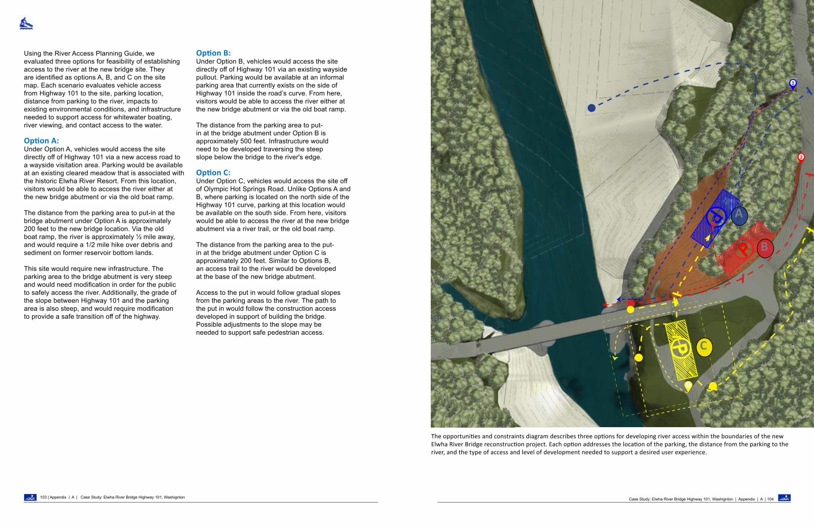
1
3
2
P
P
P
A
B
C
The opportunities and constraints diagram describes three options for developing river access within the boundaries of the new Elwha River Bridge reconstruction project. Each option addresses the location of the parking, the distance from the parking to the river, and the type of access and level of development needed to support a desired user experience.
Using the River Access Planning Guide, we evaluated three options for feasibility of establishing access to the river at the new bridge site. They are identified as options A, B, and C on the site map. Each scenario evaluates vehicle access from Highway 101 to the site, parking location, distance from parking to the river, impacts to existing environmental conditions, and infrastructure needed to support access for whitewater boating, river viewing, and contact access to the water.
Option A: Under Option A, vehicles would access the site directly off of Highway 101 via a new access road to a wayside visitation area. Parking would be available at an existing cleared meadow that is associated with the historic Elwha River Resort. From this location, visitors would be able to access the river either at the new bridge abutment or via the old boat ramp. The distance from the parking area to put-in at the bridge abutment under Option A is approximately 200 feet to the new bridge location. Via the old boat ramp, the river is approximately ½ mile away, and would require a 1/2 mile hike over debris and sediment on former reservoir bottom lands. This site would require new infrastructure. The parking area to the bridge abutment is very steep and would need modification in order for the public to safely access the river. Additionally, the grade of the slope between Highway 101 and the parking area is also steep, and would require modification to provide a safe transition off of the highway.
Option B:Under Option B, vehicles would access the site directly off of Highway 101 via an existing wayside pullout. Parking would be available at an informal parking area that currently exists on the side of Highway 101 inside the road’s curve. From here, visitors would be able to access the river either at the new bridge abutment or via the old boat ramp. The distance from the parking area to put-in at the bridge abutment under Option B is approximately 500 feet. Infrastructure would need to be developed traversing the steep slope below the bridge to the river's edge.
Option C:Under Option C, vehicles would access the site off of Olympic Hot Springs Road. Unlike Options A and B, where parking is located on the north side of the Highway 101 curve, parking at this location would be available on the south side. From here, visitors would be able to access the river at the new bridge abutment via a river trail, or the old boat ramp.
The distance from the parking area to the put-in at the bridge abutment under Option C is approximately 200 feet. Similar to Options B, an access trail to the river would be developed at the base of the new bridge abutment. Access to the put in would follow gradual slopes from the parking areas to the river. The path to the put in would follow the construction access developed in support of building the bridge. Possible adjustments to the slope may be needed to support safe pedestrian access.
Case Study: Elwha River Bridge Highway 101, Washignton | Appendix | A | 104103 | Appendix | A | Case Study: Elwha River Bridge Highway 101, Washignton

C
1
2
3
7
Site Progam 1. Lower Primary Parking Area2. Upper Secondary Parking and Maintenance Area3. Paddler Staging Area4. Gravel Beach upstream 5. River Eddy and Put in6. River Access Trail from Parking Areas7. Vegetation Enhancement Areas8. Access trail
4
6
7
7
7
6
8
5
9
8
Prefered Alternative The desired experience at this site is to provide river access for paddlers while providing opportunities for visitors to experience and interpret the ecology and history of the river. In developing river access within the confines of the new Highway 101 Bridge construction project, Option C is the best option to meet the program elements identified through the River Access Planning Guide while meeting the desired user experience. Option C is the ideal alternative because:
• It provides an opportunity to develop a river access site for river runners while providing day users with access for passive recreation within a contained site;
• The parking area is 200 feet from the river, which is an ideal distance for paddlers and rafters;
• Drivers access the site from Olympic Hot Springs Road, which is a safer alternative than Highway 101;
• The site’s slope between the parking area and the river is gradual, requiring less infrastructure than Options A and B.
More specifically, Option C could involve two small parking areas, connected by a trail, located on the terrace above the river. These parking areas would be screened with vegetation to limit visibility of vehicles from the river. Staging areas at the edge of the parking would allow paddlers to unload their gear. A trail would lead from the parking lots to the river via a landscaped grade adjacent to the bridge or natural steps down to the river’s edge. For any future option at the site, an ideal put-in and take-out would utilize the existing gravel shoreline located upstream from the proposed bridge abutment or an alternative site downstream of the bridge abutment. Ideally, an eddy would protect the access site.
Case Study: Elwha River Bridge Highway 101, Washignton | Appendix | A | 106105 | Appendix | A | Case Study: Elwha River Bridge Highway 101, Washignton

River Access Planning Guide
Appendix B:Background Trends in Paddlesportsby Thomas O’Keefe
Background Trends in Paddle Sports | Appendix | B | 108107 | Appendix | B | Background Trends in Paddle Sports

Immortalized in the painting, Fur Traders Descending the Missouri, George Caleb Bingham captured the historical importance of rivers for commerce and trade in the mid 19th century. Today, river runners can still explore remnants of this landscape along the Upper Missouri Wild and Scenic River in Montana and the Missouri Wild and Scenic River in Nebraska and South Dakota. Source: Metropolitan Museum of Art.
Hydrologic data for the United States illustrates the vast network of waterways across the nation that create a national system of water trails. Water trails have been used for thousands of years and are today popular for recreation. Credit: Nelson Minar
APPENDIX BBACKGROUND AND TRENDS IN PADDLE SPORTS
IntroductionFrom mountains to marine environments, river systems transect landscapes and provide diverse experiences for all levels of passive and active recreation users, both in and along rivers. With three and a half million miles of rivers extending throughout the United States, our nation’s rivers represent a vast network of water trails. Native Americans and early settlers used these trails for travel and commerce. Today, many of our nation’s waterways are also utilized for recreational enjoyment and exploration of our cultural heritage.
Any river system or connected series of waterways can serve as a water trail. Some water trails are primarily only known to locals, while others are more formalized with developed access points, wayfinding information, and developed facilities. Exemplary water trails are recognized by the National Water Trails System, which is a distinctive national network of designated water trails that are cooperatively supported and sustained.
Water trails, whether designated or informal, must include access points that are at an appropriate distance from one another for the length of the trip that paddlers typically make. For an afternoon trip, river runners may require access points within 5 miles of each other. In contrast, for week-long trips, access points may be separated by 100 miles or more. Some planning efforts may be initiated by a local community seeking to improve the connection between a river and the community. Other planning efforts may be part of a more formal water trail that is developed by experienced recreation planners.
Rivers serve as a setting for many recreational activities, whether they occur on the water, like boating, or they depend on access to the water as a critical component of the recreation experience, such as hiking and camping. Projects that seek to enhance access for river runners can easily become popular for day users who want to enjoy time by the river. Anticipating and accommodating these uses or providing alternative sites is important to consider in site design. Credit: Thomas O’Keefe.
While lightweight inflatables have been available for years, a new generation of packrafts constructed from advanced lightweight materials have been on the market for the past decade and have proven their durability in wilderness settings. This is one example of how technology has made it feasible to experience rivers in new ways. As technology advances, river managers will need to continually evaluate user impacts and whether river access facilities are adequately meeting user needs. Credit: Kevin Colburn.
Stand up paddleboards (SUP) have increased in popularity as a river-running craft. Many SUP users utilize existing access facilities, leading to an increase in public use. This expanded interest brings demand for improved access. Credit: Bob Wick.
PADDLESPORTS PARTICIPATION AND TRENDS:In addition to serving water-based activities, waterways also enhance the quality of many recreational activities in close proximity—even when they are not strictly dependent on the water resource.1 This is important for river managers to understand given that sites designed for river access may be used by others desiring access to the water.
The economic impact of water-based recreation continues to grow. The Outdoor Industry Association reports that citizens spent $140 billion on water sports related products in 2017, providing 1.2 million jobs.2 Additionally, the 2015 Outdoor Foundation Annual Special Report on Paddlesports found that paddlesports have continued to grow, with over 21.7 million Americans (about 7.4 percent of the population) participating in 2014. This is an increase of more than 3 million participants since 2010.3
PADDLESPORTS: THE FUTUREWatercraft Technology and Development: The recent development of packrafting and stand up paddle boarding demonstrates that new equipment and techniques can expand interest in paddlesports. Additionally, technological advances resulting in lighter and higher performance equipment mean users can access new routes and experience traditional runs in new ways. For example, trips that once required hiking with heavy hard shell kayaks and associated camping gear are now much more accessible with the development of high performance packrafts and lightweight camping gear. Advances in technological gear is not new; the adoption of rubber boats in the 1950’s and transition to plastic kayaks in the 1980s represent similar advances that greatly expanded the types of rivers that could be boated.
Background Trends in Paddle Sports | Appendix | B | 110109| Appendix | B | Background Trends in Paddle Sports

Rivers like the Sitkum on Washington’s Olympic Peninsula are characterized by a small drainage where flows can fluctuate widely. Access to real-time flow information and weather data allows paddlers to more frequently catch creeks like this at optimal flows, leading to increased use. Credit: Thomas O’Keefe.
Heavily polluted waterways like the Duwamish River in Seattle are being cleaned up. This opens the door for new recreation opportunities–including paddlesports–creating new demand for access. Credit: Thomas O’Keefe.
Endnotes: 1) Kakoyannis, C. and S.H. George. 2002. Assessing and evaluating recreational uses of water resources: implications of an integrated management framework. Gen. Tech. Rep. PNW-GTR-536. USDA Forest Service, Pacific Northwest Research Station.
2) Outdoor Recreation Economy Report 2017 <https://outdoorindustry.org/resource/2017-outdoor-recreation-economy-report>.
3) 2015 Special Report on Paddlesports <https://outdoorindustry.org/wp-content/uploads/2017/05/2015-Paddlesports-Research.pdf>.
INFORMATION TECHNOLOGY:River runners were among the first outdoor recreationists to directly integrate geospatial data, weather information, and online real-time flow information to make decisions on where to go paddling. From calling a local resident along the river who could read the gage on a bridge, to flow phones and internet gages, to advanced hydrologic forecasting, available tools that provide water information continue to evolve. Preferred means of communication have also adapted to become more modern, with printed club newsletters transitioning to online forums and social media. Technology and the way paddlers communicate and share information on rivers, access, and conditions will continue to evolve and influence use patterns.
SHIFTS IN WATERWAY USEMany rivers that were once utilized by industry have become increasingly important for outdoor recreation as economic drivers. With the implementation of the Clean Water Act, rivers that were highly contaminated due to industrial waste discharge, including the Cuyahoga in Ohio, Pigeon in North Carolina, Fox River in Wisconsin, and Duwamish in Washington, are now safe for recreation and have become paddlesport destinations. Additionally, hydropower dams that once dewatered rivers have been relicensed under modern environmental regulations that require hydropower operators to release instream flows. Examples include the Feather River in California and the Deerfield River in Massachusetts that attract thousands of paddlers a year. On some rivers, like the Tuckaseegee in North Carolina or White Salmon in Washington, dams have been removed, opening new river segments that had been drowned under reservoirs. Rivers surrounded by riparian forests largely valued for timber production and primarily used for log drives like the Flambeau in Wisconsin and the Snoqualmie in Washington, are now predominantly known as paddling destinations.
Publications and Approaches to Developing and Managing Water Access | Appendix | B | 112111 | Appendix | B | Background Trends in Paddle Sports
River Access Planning Guide
Appendix C: Publications and Approaches to Developing and Managing Water Access by Thomas O’Keefe

113 | Appendix | C | Publications and Approaches to Developing and Managing Water Access Paddlecraft Activity Sheets | Appendix | D | 114
This publication seeks to fill a gap by providing a framework to guide a holistic evaluation of the setting. The Framework includes both the site characteristics and resource users to assist with planning for access that fits contextually within the recreation setting.
Several existing publications that provide information on developing river access sites may complement this planning. The following publications provide useful information for site design and planning, especially site setting characteristics and potential facilities. They do not focus heavily on desired conditions, types of user experiences, or evaluation of recreational opportunities alongside site conditions; they can provide site managers ideas on different approaches to selecting facilities that support their management objectives.
The focus of these resources are largely on access sites within the context of urban or developed recreation areas and emphasize the technical details of site engineering. Some of the documents outline more detailed methodologies for recreation planning, including development of formal river or land management plans, recreation plans associated with hydropower licensing, or other assessments conducted as part of local, state, or federal planning requirements.
LOGICAL LASTING LAUNCHES, 2004: DESIGN GUIDANCE FOR CANOE AND KAYAK LAUNCHES: This publication offers guidance in designing canoe and kayak launches for a variety of access sites. It groups descriptions, design documents, engineering details and photos of launches into eleven chapters. Each chapter is organized according to the method of entry into the water, i.e., the type of launch. The guide provides numerous examples of each type within a suite of specific site conditions, inspiring the reader to think creatively about how to design launch facilities appropriate for their circumstances.
DEVELOPING WATER TRAILS IN IOWA, GUIDE, 2010 : This document provides practical guidelines and templates for planning, site design, signage, and construction of water trails in the state of Iowa. This guide is a useful reference for managers to plan for water trails on public lands. The document serves four levels of experience: Gateway, Recreational, Challenge, and Wilderness. Different launch designs relate to different experiences, edge conditions (relationships between the site and the river system), and setting types. The guide also covers Universal Design principles.
WATER AND LAND RECREATION OPPORTUNITY SPECTRUM (WALROS) USERS’ HANDBOOK, SECOND EDITION, 2011: WALROS provides a framework and procedure for water-based recreation. It encourages planners and managers to assess the physical, social, and managerial attributes of a river and how they relate to a diverse spectrum of water and land based recreational opportunities. It includes important guidance on resource inventory and public planning consistent with the National Environmental Policy Act.
MICHIGAN WATER TRAILS MANUAL, 2017: This manual is focused on developing water trails that are organized, supported, and managed by a dedicated entity or community partnership that is committed to long-term funding, development, and management. Guidance on planning a water trail includes extensive discussion of community engagement, signage, wayfinding, and promotion. The manual discusses elements of access design, including launch placement, physical elements, types, and accessibility considerations.
PREPARE TO LAUNCH!: GUIDELINES FOR ASSESSING, DESIGNING, AND BUILDING LAUNCH SITES FOR CARRY-IN WATERCRAFT, UPDATED 2018: The guidelines in this publication were developed to help facility and trail planners as well as park and recreation project leaders when planning, building, or updating access sites for canoeists, kayakers, tubers, stand-up paddlers, rowers, and small-craft sailors. Topic areas include understanding launch locations, addressing users’ launch needs, understanding launch design criteria, and promoting launch projects. The guide includes numerous examples to inspire thinking on different site-specific approaches.
SAN FRANCISCO BAY AREA WATER TRAIL DESIGN GUIDELINES, 2019: These design guidelines developed for the San Francisco Bay Area Water Trail can be applied to other settings, particularly those in an estuary environment or a constructed landscape setting. The guidelines cover design approach, facility design, launch principles, case studies, and project implementation. The guidelines also discuss different paddle craft types, specific access needs and the importance of understanding desired user experience.
River Access Planning Guide
Appendix D : Paddlecraft Activity Sheets by Joni Gore and Kelleen Lanagan
Wild and Scenic River FellowsNational Park Service

INTRODUCTION:This appendix provides a description of non-motorized watercraft commonly used on rivers and the access needs associated with their users. Access needs depend primarily on the type of watercraft, user abilities, desired user experiences, and existing site conditions. While this overview aims to equip river managers with general information about craft and their users’ access preferences and needs, it is not an exhaustive list nor does it account for the variability and evolving nature of river settings, recreational uses, and social dynamics.
All river managers should develop a plan for educating users about river stewardship and safety and update it periodically. Educating river users can be addressed through a variety of strategies varying from signage to outreach. Ultimately each river manager must choose a method that is specific to the users at their site.
This document is based on the Design Guidelines by the San Francisco Bay Area Water Trail. The Design Guidelines include a chapter on water trail use, describing launch design preferences, and types of craft used.
ACCESSIBILITY:Watercraft can be used and enjoyed by people with varying abilities, so it is important to design access that is universally accessible. Universal Design is a design process for accommodating everyone and makes access usable by all people to the greatest extent possible. Universal Design inherently addresses the needs of all watercraft that can carried down to the river.
Structural facilities including buildings, wharfs, and docks have minimum standards that are required by law to be accessible. Universal Design broadens this scope to include not only minimum standards, but also best practices that apply to every paddle craft and individual.
For more information on Universal Design and accessibility, please refer to additional resources including Everyone’s Nature by Carol Hunter, Iowa Water Trail guide, Oregon State Marine Board design guidelines, and Prepare to Launch.
TRANSPORTATION: Whitewater kayaks can be transported on car-top carriers, in truck beds, or on trailers. They are lightweight and can be carried to the water’s edge by propping the cockpit on one’s shoulder.
ACCESS PREFERENCES: Whitewater kayakers prefer access with a small staging area near their vehicle where they can prepare their gear and socialize with fellow paddlers. A hiking trail is usually sufficient for whitewater kayakers to reach the water. Beaches, cobble bars, or low-angle bedrock shelves situated at eddies or other flat water are ideal access locations.
USE ON THE RIVER: Whitewater kayaks are designed for use in a variety of river settings from small riffles to large and challenging rapids. In the event of a flip, a whitewater kayak can be righted easily by the paddler using an eskimo roll. Creek boats are typically the boat of choice for difficult or remote river sections, while play boats and river runners are the craft most often seen on beginner through intermediate runs.
ADDITIONAL CONSIDERATIONS: • At sites where a specific river feature (e.g., a surf
wave or play hole) exists, whitewater kayakers enjoy river access that is located where it is easy to paddle to the feature and paddle or hike back to the access point.
• Whitewater kayakers will portage around rapids they feel may exceed their comfort and/or skill level. They may create social trails and access unless one is provided for them.
• Managers should consider developing access routes around specific rapids or obstacles to minimize impacts to resources and river values, and consider partnering with local organizations who can help develop access features.
INTRODUCTION: Whitewater kayaks are plastic or composite watercraft designed to maneuver nimbly through whitewater rapids. They come in three basic types (creek, play, and river-runner) that allow whitewater kayakers to play in various whitewater features and travel downriver.
WHITEWATER KAYAKS
OverviewSize and weight: 6-12 feet long, approximately 2 feet wide, under 50 lbs
Propulsion: Double-bladed paddle
Capacity: 1-2 paddlers, typically 1
Access needs and preferences: • Need staging area to prepare equipment; • Prefer gentle slope to water’s edge; • Prefer to enter river where waters are calm
(e.g. an eddy)
Three paddlers getting into whitewater kayaks on the Smith River, CA along a cobble beach below a highway bridgeCredit: Thomas O’Keefe.fe
Paddlecraft Activity Sheets | Appendix | D | 116115 | Appendix | D | Paddlecraft Activity Sheets

RECREATIONAL KAYAKS
Overview Size and weight: 6-12 feet long, approximately 2 feet wide, under 50 lbs
Propulsion: Double-bladed paddle
Capacity: 1 or more paddlers
Access needs and preferences: • Need staging area to prepare equipment; • Prefer gentle slope to water’s edge; • Prefer to enter river where waters are calm
(e.g. an eddy)
A busy river shoreline with a crowd of paddlers getting into recreational kayaks along the Lower Delaware River, NJ/PA. Credit: Julia Bell.
TRANSPORTATION: Recreational kayaks can be transported on car-top carriers, in truck beds, or on trailers. They are most often carried to the water’s edge with a partner by handles at the front and back ends of the boat. Some paddlers use kayak dollies to roll their kayak to the water’s edge.
ACCESS PREFERENCES: Recreational kayakers prefer access with a small staging area close to the water’s edge. If there is a trail down to the water, the trail should be wide enough for two people to carry the kayaks and level enough to roll the kayaks with a kayak dolly. Docks, beaches, cobble bars, or low-angle bedrock shelves situated at eddies or other flat water are ideal access locations.
USE ON THE RIVER: Recreational kayaks are used by paddlers who may be looking for a casual paddling experience. Anglers, photographers, and novice paddlers can all use recreational kayaks to have a successful and enjoyable experience on the water. While recreational kayaks are often used for flatwater floats, they can also be used on beginner rapids (class I & II) and riffles.intermediate runs.
INTRODUCTION: Recreational kayaks are watercraft generally produced in plastic and used for more casual river trips on flatwater or riffles. Recreational kayaks also come in inflatable models. Recreational kayaks can be piloted by an individual or in tandem, and are sometimes designed to accommodate a child or pet.
USE ON THE RIVER: Oar frames are very heavy when fully loaded, so minimal distance to the river’s edge and a large staging area nearby is preferred. To reduce conflict and enhance capacity, designate an area for trailer access and another for rigging or derigging.
USE ON THE RIVER: Oar frames can be used to navigate challenging whitewater and are excellent craft for floating on multi-day river trips. They are not as maneuverable as whitewater kayaks, but they can carry gear and food for long trips.
OAR FRAME RAFTS
OverviewSize and weight: 10-20 feet long, 7-10 feet wide, 80-500 lbs unloaded, 1000-4000 lbs loaded
Propulsion: Two single-bladed oars
Capacity: One rower, sometimes with several passengers
Access needs and preferences: Need staging area to prepare equipment, preferably at water’s edge; Prefer to enter river where waters are calm (e.g. an eddy)
Whitewater rafts lined up along the Payette River in Idaho at the Banks access site, with a small parking lot in the background and a vehicle ramp leading to the water’s edge. Credit: Thomas O’Keefe.
TRANSPORTATION: A raft referenced as an “oar rig” or “oar frame” is an inflatable whitewater craft strapped with a metal frame that supports the oars and holds gear within the raft. Oar frames are maneuvered by a single rower who sits in the center of the raft and uses two oars that are attached to the frame. Catarafts are equipped similarly, but rely on a pair of longitudinally parallel inflatable tubes that are connected via the metal frame. Oar frames and catarafts typically provide ample room to hold passengers and store equipment for overnight or multi-day trips.
ACCESS PREFERENCES: Many rafters transport their fully inflated and loaded boats via trailer. Several people may pick up the oar frame by the side handles from the trailer and drop it close to the river. In some situations, ramps or boat slides are necessary to launch rafts into the water. If the raft is inflated and unloaded, a single individual can slide the raft from the trailer directly into the water or transfer it to the boat slide. If the raft is brought to the river deflated, one to two people will hoist the deflated raft from a vehicle to a place where it can be pumped, transfer the pumped raft to the river by the side handles, and assemble the frame and gear close to the water.
INTRODUCTION: A raft referenced as an “oar rig” or “oar frame” is an inflatable whitewater craft strapped with a metal frame that supports the oars and holds gear within the raft. Oar frames are maneuvered by a single rower who sits in the center of the raft and uses two oars that are attached to the frame. Catarafts are equipped similarly, but rely on a pair of longitudinally parallel inflatable tubes that are connected via the metal frame. Oar frames and catarafts typically provide ample room to hold passengers and store.
Paddlecraft Activity Sheets | Appendix | D | 118117 | Appendix | D | Paddlecraft Activity Sheets
ADDITIONAL CONSIDERATIONS:
• The size of the staging area should be able to accommodate the maximum number of users at any given time.
• Providing a rapid inflation station (via an outlet or generator) allows deflated rafts to get on the river more quickly, reducing conflict at the access site and enhancing capacity by making it easier for more craft to launch safely.

PADDLE RAFTS
Size and weight: 10-18 feet long, 7-10 feet wide, 100-200 lbs
Propulsion: Single-bladed paddles
Capacity: 1-16 paddlers and a guide; typically up to 6paddlers
Access needs and preferences: Need staging area to prepare equipment and orient participants; Prefer to enter river where waters are calm (e.g. an eddy)
Overview
Two groups of paddlers in rafts navigate through a whitewater rapid on the Chattooga River, in South Carolina, in a green forested landscape. Credit: Thomas O’Keefe.
TRANSPORTATION: Paddle rafts are typical craft provided by an outfitter, and are hauled by trailers when inflated or brought by vehicle when deflated. Trip participants may be asked to pick up an inflated raft by the side handles and drop it close to the river, though a single individual may be able to slide the raft from the trailer to the water. Deflated rafts are hoisted by one to two people and carried to a place where it can be pumped with air by a hand or electric pump means and transferred to the river by the side handles.
ACCESS PREFERENCES: Raft guides and trip leaders typically give safety talks on land prior to launching, so a large staging/gathering area should be designated for these groups and their participants. Minimal distance to carry paddle rafts from the staging area to the river’s edge is preferred; otherwise, rails, ramps, or boat slides are helpful.
USE ON THE RIVER: Paddle rafts are often used by outfitters to navigate moderate to challenging whitewater. Paddle rafts are not as maneuverable as whitewater kayaks. Participants (especially those with minimal training) are accompanied by a professional guide who provides paddling instructions. Paddle rafts can be used for single day trips or for multi-day trips; they are usually accompanied by oar frame rafts for multi-day trips.
ADDITIONAL CONSIDERATIONS: • When a trail is used to provide access to the
water’s edge, plan for at least 4 additional feet oftrail width to accommodate paddlers carrying theraft on both sides.
• Providing a rapid inflation station (via an outletor generator) allows deflated rafts to get on theriver more quickly, reducing conflict at the accesssite and enhancing capacity by making it easierfor more craft to launch safely.
INTRODUCTION: Paddle rafts are large, inflatable whitewater craft that typically hold up to 6 paddlers and a guide. Paddle rafts are powered by the paddlers and steered by a guide in the back of the raft.
PACKRAFTS
Size and weight: 4-8 feet long and 2-3 feet wide wheninflated, approximately 2 feet wide whenpacked; under 10 lbs
Propulsion: Double-bladed paddle
Capacity: 1-2 paddlers, typically 1
Access needs and preferences: Prefer remote and/or primitive access
Overview
A packrafter paddles down a calm stretch of river between the gates of a caldera on the Aniakchak River, in Alaska.Credit: Thomas O’Keefe.
TRANSPORTATION: A deflated and folded packraft can be carried in any vehicle, packed into a backpack, or strapped onto a bike. Users can transport packrafts many miles to reach a river access site. Packrafts are inflated with a pump or inflation bag.
ACCESS PREFERENCES: Avid packraft users tend to seek backcountry experiences by hiking or biking to a river access site to begin their trip, then paddling downstream to their destination. These users often prefer a more natural experience, such that many pack rafters would be satisfied with a trail to the water’s edge. At the launch site, paddlers will inflate their packraft, pack any gear from the journey (e.g., a backpack or bike), and then paddle downstream.
USE ON THE RIVER: Packrafts can be used for day use and multi-day expeditions, from calm water to challenging rapids. Some users will hike or bike miles along a trail to a launch site, then paddle downstream in a packraft to return to their destination.
INTRODUCTION: Packrafts are small, lightweight inflatable watercraft that are very easy to transport. Packrafts can be used on the river for leisurely paddles on flatwater or for adventurous multi-activity trips in the backcountry. Backpackers may use packrafts when they need to cross rivers to reach the other side of the trail.
Paddlecraft Activity Sheets | Appendix | D | 120 119 | Appendix | D | Paddlecraft Activity Sheets

Appendix | 122 121 | Appendix | D | Paddlecraft Activity Sheets
INNER/RIVER TUBES
Size and weight: When inflated, single tubes can be 4-5 feet in diameter; under 15 lbs
Propulsion: The river’s flow and some steering with hand-paddling
Capacity: 1 person (see also “additional considerations”)
Access needs and preferences: Tubers can access the river from almost any access, but they prefer to launch at eddies or in calm water
Overview
Three river tubers paddle into the Snoqualmie River in Washington as they float on a calm stretch of a wide river. Credit: Thomas O’Keefe.
TRANSPORTATION: A deflated tube can be easily carried in vehicles, in packs, or on bikes. Deflated inner tubes can be inflated with a pump and carried to the water’s edge
ACCESS PREFERENCES: While tubers can access the river in most places, their access should be supported with a large parking area with bathrooms and trash facilities. A large staging area should be provided to accommodate large numbers of tubers, who may be inflating and packing their inner tubes in the parking lot, to minimize congestion and conflict. Safety and stewardship signage is particularly important at popular tuber access sites.
USE ON THE RIVER: Tubes are often used for day trips on calmer stretches of river where users rely on the current to move down the river. Tubers often enjoy the river in large groups. This activity is most popular in the summer when the weather is warm and the river flow is low.
ADDITIONAL CONSIDERATIONS:
• Tube size varies on tube design and whether users rope several tubes together.
• Tubers may also pack snacks and beverages to be consumed on the river.
INTRODUCTION: Inflated tubes are used to float down calm stretches of river, sometimes with riffles. Tubers require little river-running expertise; therefore, this activity appeals to many users.
STAND-UP PADDLEBOARDS
Size and weight: 7-14 feet long, 2-3 feet wide, under 30 lbs
Propulsion: Single-bladed paddle
Capacity: 1 paddler
Access needs and preferences: Need staging area to prepare equipment; Prefer gentle slope to water’s edge; Prefer to enter river where waters are calm (e.g. an eddy)
Overview
A paddler holds onto a stand-up paddleboard as they wade into the river at an access spot near a small campsite facility on the Nolichucky River, TN. Credit: Kevin Colburn.
TRANSPORTATION: SUPs can be transported by car and carried from the car to the water’s edge. Rigid SUPs are usually strapped to the car top, while inflatable SUP models can be packed down to fit in most car trunks and then inflated with a foot-pump at the staging area. A grab loop in the center of the board allows a single paddler to carry a SUP like a briefcase.
ACCESS PREFERENCES: SUPs can be launched from most access points. SUP paddlers can utilize popular access or hike several miles with their inflatable SUP to put-in. While an ideal launch may include a dock with a handrail, SUPs can also launch from beaches, cobble bars, or low-angle bedrock shelves situated at eddies.
USE ON THE RIVER: SUPs are most commonly used in calm stretches of river, although paddling whitewater with SUPs is a growing trend. SUPs can be used for single day trips or for multi-day trips. For multi-day trips, paddlers can strap down gear to the front of the SUP.
ADDITIONAL CONSIDERATIONS:
• Similar to whitewater kayakers, stand-up whitewater paddlers enjoy river access for specific river features (e.g., a surf wave) where it is easy to paddle to the feature and paddle or hike back to the access point. Paddle boarders may create social trails and access unless one is provided for them.
INTRODUCTION: Paddlers stand upright on their stand-up paddleboard (SUP) and use a long paddle to propel across the water. SUPs are generally used on calmer stretches of water, but they can be used on beginner and intermediate whitewater as well.

123 | Appendix | D | Paddlecraft Activity Sheets
CANOESINTRODUCTION: Canoes are open-hulled boats that are most often used for flatwater and beginner rapids (Class II) and riffles. They feature room to store equipment and gear, and are thereby well-suited to use for overnight and multi-day trips. Calmwater or ‘tripping’ canoes are designed to move in a straight line, requiring less maneuvering for beginners to have a successful and enjoyable experience. Some canoes are designed to be outfitted with a whitewater spray deck and can be run through challenging whitewater safely.
TRANSPORTATION: Canoes can be transported on car-top carriers, in truck beds, or on trailers. They are most often carried to the water’s edge with a partner by rope loops or built-in handles at the front and back ends of the boat.
ACCESS PREFERENCES: Canoeists prefer access with a small staging area close to the water’s edge where they can prepare their gear and socialize with fellow paddlers. A trail down to the water should be wide enough for two people to carry a canoe, one at each end. Docks, beaches, cobble bars, or low-angle bedrock shelves situated at eddies or calm water are ideal access locations.
USE ON THE RIVER: Canoes are used by paddlers who may be looking for a casual experience on the water, such as anglers, photographers, and novice paddlers. While canoes are often used for flatwater floats, they can also be used on beginner rapids (Class II) and riffles. Because of their abundant space to store gear and equipment, canoes are usually the craft of choice for multi-day trips, notably where long distances will be paddled on calm or flat water.
ADDITIONAL CONSIDERATIONS:• Larger staging areas may be required for
canoeists planning a multi-day trip to prepare gear and pack their canoe.
Size and weight: 12-19 feet long; 3-4 feet wide; approximately 50 lbs for solo boats, 80 lbs for tandem models
Propulsion: Single-bladed paddle
Capacity: 1-20 people; Most models accommodate 2 paddlers
Access needs and preferences: Need staging area to prepare equipment; Prefer gentle slope to water’s edge; Prefer to enter river where waters are calm (e.g. an eddy)
Overview
Canoeists on the Namekagon Wild and Scenic River enjoy family trips with brimful canoes and expect easy access to facilities. Many boaters car camp and plan day trips to paddle different sections of the river over a weekend. Credit: Thomas O’Keefe.