Risk Root Cause Analysis Paper for PEARL (Preparing … · This research forms part of the PEARL...
43
1 Contested Development Working Paper Series Department of Geography, King’s College London _______________________________________________________________ Year 2016 Paper #72 _______________________________________________________________ Risk Root Cause Analysis Paper for PEARL (Preparing for Extreme And Rare events in coastaL regions project): The Case of Genova, Italy Dr. Anna Scolobig ETH-Swiss Federal Institute of Technology
Transcript of Risk Root Cause Analysis Paper for PEARL (Preparing … · This research forms part of the PEARL...

1
Contested Development Working Paper Series
Department of Geography,
King’s College London
_______________________________________________________________
Year 2016 Paper #72
_______________________________________________________________
Risk Root Cause Analysis Paper for PEARL
(Preparing for Extreme And Rare events in coastaL
regions project):
The Case of Genova, Italy
Dr. Anna Scolobig
ETH-Swiss Federal Institute of Technology

2
Risk root cause analysis:
the Genova case study (Italy)
Paper for the PEARL project Work Package 1- Testing the Risk Root
Cause Analysis Framework
Author: Anna Scolobig, Dr. Contact: [email protected]
Contributor: Carolina Maestri
Please do not circulate it without authors´ consent.
Table of Contents
1. Introduction.................................................................................................................. 4
2. Background to the Genova case study ................................................................. 5
2.1 Past events ........................................................................................................................... 5 2.2 The 2011 and 2014 flash floods ................................................................................... 7
3. Research design: testing the PEARL RRCA Framework ............................. 11
4. Risk and root causes analysis .............................................................................. 13
4.1 Physical pathway ............................................................................................................. 13 4.1.1 Increase of extreme events ................................................................................................13 4.1.2 Inadequate urban drainage and concrete-covered streams ................................14 4.1.3 Cascade effects on energy production, water quality and agriculture ............14
4.2 Socio-economic pathway .............................................................................................. 15 4.2.1 Social vulnerability ................................................................................................................15 4.2.2 Excessive urbanisation ........................................................................................................16 4.2.3 Funding for risk mitigation and project implementation......................................19 4.2.4 Past criteria for funding allocation .................................................................................23 4.2.5 The footprint of economic crisis ......................................................................................24 4.2.6 The implementation of austerity measures at the local level ..............................25
4.3 Governance pathway ..................................................................................................... 26 4.3.1 The perverse effects of legal trials and overregulation ..........................................26 4.3.2 Human resources constraints ...........................................................................................27 4.3.3 The mismatch between the political and disaster risk cycles .............................28 4.3.4 Official and unofficial on-line communication flows ...............................................29
4.4 Perceptions and values ................................................................................................. 30 4.4.1 The clash between the structural and non structural paradigm ........................31 4.4.2 Aware and prepared? ...........................................................................................................32 4.4.3 Community participation and empowerment ...........................................................33
5. Discussion................................................................................................................... 34
5.1 Risk drivers, root causes and causal loop analysis ............................................. 34

3
5.2 Methodological considerations for the next research phases ........................ 36 5.3 New ideas from and for practitioners ...................................................................... 38
References .......................................................................................................................... 39
Annex ................................................................................................................................... 40
Project disclaimer
This research forms part of the PEARL project, or Preparing for Extreme and Rare Events in
Coastal Regions. This is an EC funded project taking place from 2014-2018, co-ordinated by
the UNESCO-IHE Institute for Water Education, The Netherlands but involving many partner
organisations across Europe. The aim is to support the development of strategies for coastal
flood management using a multi-disciplinary approach. Findings from the project will inform
a guidebook for flood management practitioners in the EU and beyond. More information
about PEARL can be found here: http://www.pearl-fp7.eu/about-pearl/. In PEARL work
package 1, researchers at King’s College London and the University of Stuttgart lead a team of
social scientists who are undertaking studies of the economic, social and institutional causes
of risk and disasters in a number of EU and international case studies. The aim is to better
understand: i) the social causation of small scale but high local impact disaster events in
coastal regions; ii) the causes and impacts of risk (for affected groups or individuals through
the lens of a specific event or events). The findings will inform a number of publications as
well as the development of holistic risk assessment models within PEARL.
Acknowledgements
I wish to thank all the colleagues and persons who provided professional advice and
collaboration in the UK, Greece, Germany and Italy. I especially thank Prof. Mark Pelling, for
giving me the opportunity to work in a highly motivated interdisciplinary and international
research team on a very interesting case study: Genova. I also thank Carolina Maestri at ETH
Zurich, Switzerland - where I also work - for collecting the data about the funding for risk
mitigation and for the long discussions on how to disentangle the complexity of the Italian
economic and legal system for flood risk management. My gratitude goes also to Alessandra
Marchese (GISIG Genova) and Prof. Giorgio Roth (University of Genova) for their suggestions,
for sharing their profound knowledge about Genova and for helping me to kick-start the
interview process. Last but not least, I am especially thankful to the anonymous interviewees
in Genova who devoted their precious time (even in the days after the first event causing
damages in the “2015 season”) to the discussions about Genova and the Bisagno river.
Without them, this research work would not have been possible. Unfortunately I regret that
the limited time available did not allow me to better understand many local issues and
dynamics as I wished to. For sure I understood that Genova is a hub of professional risk and
emergency practitioners and researchers very much dedicated to and passionate about their
jobs. I dedicate this work to them, to their exemplary commitment and passion.

4
1. Introduction
Genova (approx. 600,000 inhabitants) is situated in North West Italy, in the Liguria
region, facing the Tyrrhenian sea. It is the sixth largest city in Italy and its
administrative limits cover a land area of 243.6 km2 (94 sq mi). Genova is the capital
of Liguria Region and the largest seaport in Italy. It is one of the major economic
centres of the country and part of the Milano-Torino and Genova industrial district.
The town’s position, between the sea and a ring of steep mountains, is particularly
exposed to severe storms and flooding.
More exactly, the town is exposed to several risks: flash floods (FF), pluvial floods (PF),
combinations of floods (CoF – rivers + sewer networks), sea level change, coastal
floods including estuarial floods (CF). Extreme events including heavy precipitation
(HP) and cyclones (C) also represent a threat.
In the past 50 years there has been a progressive increase in intensity of flood events,
including an increase in rainfall rates and the number of floods (Faccini et al. 2015).
Some areas of the town experienced one flood event per year between 2010 and 2014
(see section 2). Risk awareness among the local population grew exponentially
especially in the areas that experienced repeated events. At the same time national,
regional and local authorities responded proactively to these events, adopted new
emergency and climate adaptation plans and other measures that will be described
in this report. Civil society also responded proactively with the creation of several
NGOs whose activities are focused on emergency management, risk mitigation or
weather forecasts.
Yet, notwithstanding these efforts, the Bisagno river still remains a major danger and
risk source for Genova. What makes the situation particularly critical is that most of
its surface, especially in the town center, is covered by concrete, after a project
developed at the beginning of the XX Century. The same technique has been used to
cover about 30 other streams crossing the town.
At present the town is severely paying the consequences of past risk mitigation
decisions. The estimated costs of making the Bisagno river area safer are extremely
high, approximately 350 million euros. This estimate does not include the other rivers
and streams crossing the town (e.g. Fereggiano, Sturla, Nervi, etc.). Yet, not only the
high costs but several other different causes have contributed to generate a risk
mitigation stalemate in Genova in the past decade: the needed structural risk
mitigation measures have not been built thus exposing the population to an even
higher risk.
This report aims at describing the root causes of this stalemate and, more generally,
of flood risk and vulnerability in Genova, with a focus on the relations between social,
5
economic, legal, technical and institutional factors. From a theoretical viewpoint, the
starting assumption is that there is a need to better understand the root causes of risk
and disasters by focusing on the (under-researched) economic, social and institutional
aspects and their interactions rather than solely on the technical aspects. Therefore
the main aim is to disentangle the complexity of the social causation of small scale but
high local impact disaster events. More precisely this document reports on the testing
of the PEARL risk and root causes analysis framework (RCCA) (Fraser et al. 2014). RCCA
identifies the drivers of hazard, exposure and vulnerability related to physical, socio-
economic and governance processes. Section 2 presents the background to the
Genova case study, while Section 3 describes the research design and provides more
information about the RCCA framework. Sections 4-5 discuss the key results of the
root causes analysis.
2. Background to the Genova case study
2.1 Past events
Genova’s modern history has been deeply marked by disasters where floods, flash floods and
landslides have been of great concern for the authorities involved in risk and emergency
management as well as for residents. This history is constellated by a number of serious
floods, flash floods and landslides with damaging impacts. From 1945 on, there have been
serious events every 10-12 years. Some of them are considered particularly damaging
(Particularly the ones in 1945, 1960, 1970, 1992-1993 and 2011-2014). Table 1 presents a
detailed chronology of the major floods in Genova and the Liguria region.
Tab. 1 Events in Genova’s flood history
Events in Genova’s flood history
Year: 589, 1222, 1404, 1407,1414,1416,1420,1452,1592,1780,1787,1790,1822,1832, 1835 (66 mm in one hour/no major damage), 1842 (247 mm rain),1872,1885, 1889, 1892,1907,1908,1926,1945,1951,1952,1970 (400 mm rain in 24 hours), 1975, 1977 (500 mm)
Most recent events: 1992: 282 mm in 12 hours 1993: 300 mm 1994: tornado 1995 to 2000: High precipitations every year 2002: Lavagna valley and Genova 2005: high precipitation in Genova 2006: Genova (250 mm in 12 hours, several events with high precipitations) 2007: Recco town and Genova (Nervi stream flood) 2008-2009: high precipitation in Genova 2010: Genova (1 event btw 100-300 mm; 220 mm in the second event; several other intense precipitations), Sestri Ponente, Varazze 10.2011: Val di Vara and Cinqueterre 11.2011: Genova-Val Bisagno 10.2014: Genova

6
11.2014: Lavagna, Leivi, San Colombano and Chiavari 09. 2015: Genova
Source Faccini et al. 2015; Rossi 2014 A detailed description of each event is beyond the purpose of this report, where the focus will
be on the 2011 and 2014 events (see Section 2.2).
Box 1. Brief history of risk mitigation decisions in Genova Risk mitigation decisions have always been a critical issue in Genova. The area surrounding the Bisagno river is one of the most dangerous: decisions of what to do to improve safety levels and how have dominated the local technical and political debate since the beginning of the XX Century. Fig. 1 - The Bisagno river and its tributaries (source GISIG Genova)
Indeed on the basis of a project designed in 1909 the final part of the river has been covered with concrete. It took ten years, 1928-1938, to build the structural risk mitigation works to cover the river and made the area safer, but unfortunately only in the short term (Rossi 2014). The roofing/coverage/soil seeding guaranteed high safety standards for that time. In the following years, the same technique has been used to cover 28 out of the total 88 other streams and long rivers (88 include only the streams that are longer than 1 km) that cross the town.
However after thirty years from the construction of the roofing/coverage, the area became dangerous again because of increased urbanisation and many other factors (see section 3). The flood that hit Genova in 1970 considerably worsened the situation and represented a wake up call for local authorities. On the 7-8 October 1970, the rivers Polcevera, leiro and Bisagno flooded causing 44 casualties, 2000 evacuees and 185 homeless. In some areas of the town 950 mm of rain were measured, corresponding to 90% of annual average values.

7
Afterwards risk reduction in the Bisagno area became again a political priority, even
if the trade-offs between safety and urban development remained a critical issue.
Especially in the case of the establishment of building constraints in floodplain areas,
the local authorities had (and still have) to evaluate the relative importance of
individual freedom and private property rights on the one hand, and public safety on
the other. Conflicts have been harsh especially among decision makers and other
stakeholders with interests in economic and urban development.
At the same time the alternatives for making the Bisagno area (including its tributaries) safer started to dominate the public and political debate. Three alternatives were discussed:
Changes to the river main course Deviation of a part of the discharge streaming under the culvert toward a
tunnel directly discharging into the sea Destruction of the roofing/coverage
Not only the technical but also the political debate became very heated. In the following years resources were devoted primarily to the maintenance of already existing protection works and the discussion about alternatives continues. In the Nineties, thanks to the funding for the world football championship held in Genova (and in many other Italian towns), several projects to improve vehicle circulation and transport were implemented. This implied a reinforcing of existing protection works covering the rivers.
2.2 The 2011 and 2014 flash floods
The RCCA analysis presented in the following sections focuses on the events in
November 2011 and October 2014.
The socio-economic dynamics of the two floods are strongly inter-related. Indeed at
the town level, the event in 2014 represented an amplification of the social, technical,
economic and environmental issues that emerged after the 2011 event.
4 November 2011
A flash flood hit the Liguria region, with the most serious consequences in Genova.
The city saw 500 mm of water in 24 hours. The Bisagno and Fereggiano (a tributary of
Bisagno) streams flooded; the Sturla, Scrivia and Entella rivers burst their banks. The
event caused 6 casualties (all woman, among which 2 children). More than 1000
people were displaced. In 1970 another event (900 mm rain in 24 hours) caused 44
casualties, exactly in the same area.
At the time of writing (2015) the mayor in 2011 and four officers, including the head
of the municipal civil protection agency, are on trial. The accusation concerns
inadequate emergency management: the key issues are the failure to close public
schools and control car circulation. The defendants of the relatives of the victims

8
argue that this is the reason the casualties occured and charge the five with an
accusation of manslaughter.
The police closed the most dangerous street one hour before the casualties happened
(on the same street). Afterwards the police corps left the area because their own life
was endangered. As an unwanted consequence, the police alarm remained de-facto
unheard. As reported by the then head of the local police force to a newspaper
journalist: “We received the phone call of the inspector at 12.15. He told us that the
river in via Fereggiano flooded. At that point I told my colleagues to inform inhabitants
to reach the second or third floor of their houses. The inspector told us that if they
did not do it already, they would have been dead. At that point I realized that we
completely lost control of the situation.” (www.primocanale.it) This interview excerpt
provides some insights on the difficulties and complexity of managing an emergency
caused by a flash flood.
Fig. 2 - Floods in Genova (on-line pictures)

9

10
7-9 October 2014
In 2014 parts of the city saw 700 mm of rain fall in 72 hours, not far short of the
average rainfall of an entire year. The event caused 1 casualty, 3 wounded residents,
200 residents were displaced and the estimated damages were 500 million Euros.
Other sources (ANSA and Polaris website) estimate damages of 350 million Euros, 100
for commercial activities and 250 to households.
The Bisagno, Fereggiano and Sturla streams flooded. Water reached the peak level of
1.8 m in some areas and caused serious damage to the ground floor of most of the
buildings. Genova remained without electricity for several hours.
In this case the authorities had failed to predict the huge volume of rain which fell in
the space of a few hours and the alert was not officially given.
After the 2014 event, residents have protested against: i) administrative inertia and
the lack of action to make Genova secure after the 2011 event; ii) missed alarm. The
most contested issue concerns the delays in reinforcing the banks of the Bisagno river,
the biggest in Genova. 35 million euros set aside for protection works in 2010 had not
been spent because of a legal dispute (ricorso al TAR) and bureaucratic issues.
(http://www.reuters.com/article/2014/10/12/us-italy-flood-
idUSKCN0I00G620141012)
The Genova public prosecutor's office opened a probe after the 2014 event into a
possible man-made disaster stemming from incomplete or lacking public works that

11
were supposed to have shored up the city's flood defences. Investigators are looking
into flood prevention measures, riverbed maintenance, the city's civil protection plan,
and administrators' actions. Also because of the numerous events from 2011 on, the
2014 flood raised enormous public and media attention not only at the local but also
at the national level, including extensive press coverage.
After the event, the Italian premier Matteo Renzi commented as follows: “There is a
need to open new building construction sites in Genova. It is critical to overcome the
logic of trials and reciprocal corruption accusations which make risk reduction more
profitable for lawyers than for citizens. We are correcting these distorted mechanisms
by enacting new legislation such as the new law design to improve Public
Administration. We need to better coordinate civil protection with a major role at the
central level as the new constitutional reform will guarantee. These new laws and
decrees have already a name: Un-block Italy, Public Administration reform,
constitutional reform, justice reform, building construction sites for the “Mission unit”
(unita’ di missione) in order for Italy to be as we all want it to be (Il Sole 24 ore 12 oct
2014).” The Environment Minister released the following declaration to the Italian
national press agency (Ansa): “Several mistakes have been done in Genova in the past
but now the time has come to take over responsibility and we are committed to solve
the problems related to hydrogeological risk in this region.” (oct. 2014) The
institutional, legislative and policy changes described by the Italian premier and
Environment Ministry will be described in more detail in the following sections.
These two events open a window to better understand the root causes of flood risk and vulnerability and the complexity of the social, economic and institutional causation of these small scale but high local impact disaster events.
3. Research design: testing the PEARL RRCA Framework
The first research phase consisted of a desk study and documentary analysis of key documents
about flood risk in Genova and the Liguria region. The aim was to provide a description of i)
the institutional, political and legal framework for flood risk governance in Genova; ii) the risk
mitigation history; iii) a preliminary analysis of root causes and drivers of hazard, exposure
and vulnerability. The desk study included the collection and analysis of relevant documents,
such as newspapers articles, laws, technical reports from the regional, provincial and
municipal authorities, urban, river basin and emergency plans, climate adaptation plans,
research reports, scientific articles, grey literature and books. There is a vast literature
available in Italian about floods and flood history in Genova. Moreover because of the
increased frequency of flash floods events in recent years, the case received has received
extensive press coverage. More than 150 newspaper articles have been found online
reporting on the 2011/2014 events and/or risk mitigation and emergency management in
Genova between 2010 and 2015.
12
The second research phase consisted of 17 semi-structured interviews. Interviewees were
selected based on their status, role or experience, deep knowledge of the subject under
investigation and/or the relevant social context. They mostly included officers of various
agencies dealing with risk management at municipal, provincial and regional level (e.g. urban
planning units, environment agencies, authorities in charge of river basin plans), civil
protection managers and officers, members of the center for early warning, politicians, local
researchers and University professors, members of environmental/civil protection NGOs and
voluntary groups or associations.
The focus of the interviews was the collection of data on interviewees’ views on i) the risk and
the recent events, ii) the economic, social and institutional causes of flood hazard, risk and
vulnerability, and iii) the actions undertaken to reduce risk, including e.g. mapping, risk and
emergency planning, structural measures and defences, warning systems, training,
educational and raising awareness initiatives, etc. Moreover one of the key aims of the
research was to test the PEARL risk and root causes analysis framework in order to identify
the drivers of hazard, exposure and vulnerability related to physical, socio-economic and
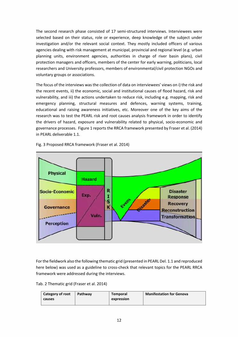
governance processes. Figure 1 reports the RRCA framework presented by Fraser et al. (2014)
in PEARL deliverable 1.1.
Fig. 3 Proposed RRCA framework (Fraser et al. 2014)
For the fieldwork also the following thematic grid (presented in PEARL Del. 1.1 and reproduced
here below) was used as a guideline to cross-check that relevant topics for the PEARL RRCA
framework were addressed during the interviews.
Tab. 2 Thematic grid (Fraser et al. 2014)
Category of root causes
Pathway Temporal expression
Manifestation for Genova
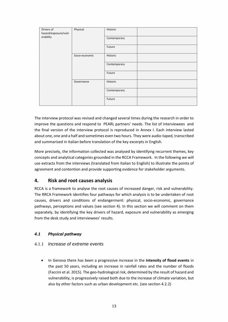
13
Drivers of hazard/exposure/vulnerability
Physical Historic
Contemporary
Future
Socio-economic Historic
Contemporary
Future
Governance Historic
Contemporary
Future
The interview protocol was revised and changed several times during the research in order to
improve the questions and respond to PEARL partners’ needs. The list of interviewees and
the final version of the interview protocol is reproduced in Annex I. Each interview lasted
about one, one and a half and sometimes even two hours. They were audio-taped, transcribed
and summarised in Italian before translation of the key excerpts in English.
More precisely, the information collected was analysed by identifying recurrent themes, key
concepts and analytical categories grounded in the RCCA Framework. In the following we will
use extracts from the interviews (translated from Italian to English) to illustrate the points of
agreement and contention and provide supporting evidence for stakeholder arguments.
4. Risk and root causes analysis
RCCA is a framework to analyse the root causes of increased danger, risk and vulnerability.
The RRCA Framework identifies four pathways for which analysis is to be undertaken of root
causes, drivers and conditions of endangerment: physical, socio-economic, governance
pathways, perceptions and values (see section 4). In this section we will comment on them
separately, by identifying the key drivers of hazard, exposure and vulnerability as emerging
from the desk study and interviewees’ results.
4.1 Physical pathway
4.1.1 Increase of extreme events
In Genova there has been a progressive increase in the intensity of flood events in
the past 50 years, including an increase in rainfall rates and the number of floods
(Faccini et al. 2015). The geo-hydrological risk, determined by the result of hazard and
vulnerability, is progressively raised both due to the increase of climate variation, but
also by other factors such as urban development etc. (see section 4.2.2)
14
• Genova represents an exceptional case for Italy in terms of its susceptibility to flash
floods. Two physical factors in particular contribute to increased flood risk on the
territory: a high probability of “cellule temporalesche rigeneranti”(called water
bombs) causing intense precipitation and steep mountains which make flash floods
harder to predict and faster to propagate. (int.7)
• As reported by an interviewee “extreme and exceptional events similar to the ones in
2011 and 2014 are becoming more and more ‘standard’ events. On the one side,
global warming is worsening the situation. On the other side, urbanisation is
increasing risk exposure enormously: more people, buildings and infrastructures are
now at risk.” (int. 5) Yet, it is also important to keep in mind that most of the river
basins are relatively small (15 km2 or so) and that intense rain and flash floods can
affect one neighbourhood of the town and leave the next one untouched (int. 8).
4.1.2 Inadequate urban drainage and concrete-covered streams
• One of the key problems (amplified by extreme events and urbanisation trends) is
inadequate urban drainage. This includes the inability of the system to cope with
larger rainfall events, due to inadequate channel capacity. Due to historical reasons
and (sometimes) inadequate past urban planning decisions, streets are narrow,
restricting the amplification of storm water channels.
• Another problem is related to the concrete-covered streams which indirectly affect
urban drainage too. At the beginning of the XX Century the concrete-covered
rivers/streams guaranteed high safety standards for that time, even if now many
interviewees lament - retrospectively - that this generated higher levels of
vulnerability. The same technique has been used to cover 28 out of the total 88 other
streams and long rivers (88 include only the streams that are longer than 1 km) that
cross the town. “One of the critical problems is that water cannot be absorbed by the
soil anymore. Genova soil is completely waterproof! ” (int.5)
4.1.3 Cascade effects on energy production, water quality and agriculture
In the future it is expected that climate change will cause not only more frequent
heavy rainfall events (as described above see 4.1.1) but also more frequent drought
periods. One of the major expected consequences is the worsening of water quality
from riverine intakes. Moreover less water is expected to be available for drinking
purposes. (Prepared Enabling EC project; http://www.prepared-fp7.eu/prepared-
home2).
Therefore in the future, less water is expected to be available for alternative usage
such as hydro-power production. In the long term this can cause an increase in the
water and energy prices, thus affecting the local economy. Moreover previous
research in the area revealed that the fear of future water scarcity is causing over-

15
conservative behaviours among water managers (http://www.prepared-
fp7.eu/prepared-genoa-italy).
Another example of cascade effects between weather events and the economy is that
the extreme events in 2014 have resulted in a poor year for the wine industry and
farming in the area. In the north, the grape harvest fell by as much as 20 percent.
Production fell 17 percent compared with 2013, making it the worst year since 1950.
http://floodlist.com/europe/severe-weather-leaves-2-dead-northern-italy
4.2 Socio-economic pathway
4.2.1 Social vulnerability
Liguria sets a record among Italian regions: it is 1st place per average age, per %
inhabitants > 64 years old and per old-age index. 27% of Genova inhabitants are over
64 years (vs. 20% for national statistics - Italy).
http://www.urbistat.it/AdminStat/en/it/demografia/eta/genova/10/3
Yet, even if age is not the only predictor of increased social vulnerability, emergency
managers (int. 5 and 9) maintain that it can affect significantly the person’s ability to
prepare for, respond to and recover from disasters. They report to be seriously
worried about their capabilities to provide help to all the elderly in need during an
event (int. 5, 8, 9). Even if they maintain that it is clear that age alone does not make
a person vulnerable, this can significantly affect the response capacity. The oldest old
(85+) and chronically ill or disabled worry emergency managers the most. At the same
time some elderly people know the town very well and have proved to be resilient in
many occasions.
Based on their experience, emergency managers are also particularly worried about
other socially vulnerable groups such as immigrants and woman (int. 9). Yet the
problem is that it is very difficult to target these groups for raising awareness or
preparedness campaigns. “Our strategy is rather to target existing local associations
or interests groups with the aim to help them to improve their self protection skills.”
(int. 9)
Demographic trends and especially the population risk exposure need also to be
taken into account with respect to the RRCA analysis. In the region Liguria, 19% of the
inhabitants (n=304'303) are exposed to flood risk (ISPRA 2014; total inhabitants:
1'565'127). Only two other Italian regions, Toscana and Emilia Romagna, have higher
percentages of inhabitants exposed to flood risk than Liguria (respectively 45% and
29%, ISPRA 2014).
Genova’s population rose from about 240,000 inhabitants (1861) to a maximum of
850,000 in the early ´70s. This represented the highest peak and even if the
urbanisation of the hills still continued in the 80s and 90s (Faccini at al. 2015), the

16
population decreased. At present the population is about 600,000 inhab. (592,995 ;
2014 Census, ISTAT 2015). Yet, as reported by the municipal authorities in charge of
emergency management: “We should not forget that we have 115,000 residents at
high risk in Genova. As an emergency manager I will never be able to know enough
about the individual vulnerability of 115,000 residents” (int. 5) A final factor affecting
residents’ vulnerability is that many houses actually act as river/stream banks.
Residents living on the ground floor in high risky areas are especially endangered (int.
5). “Some neighborhoods (e.g. Borgo Incrociati) have been flooded each year in the
past 4 years.” (int.9) Even if these households have developed self-protection
strategies to increase their resilience, the level of post-traumatic stress and related
disorders is high.
4.2.2 Excessive urbanisation
Excessive urbanisation can be a serious problem affecting river basins and alluvial
plains. There was a widespread agreement among interviewees on the fact that the
excessive urbanisation in the past was and still is a major risk driver in Genova (int.
1,2,3,4,5,9,15,16,17). Most of the interviewees actually mentioned it as the primary
risk driver: “more than 100 streams have been covered with concrete, streets or
buildings in Genova. This is the main root cause of risk and vulnerability in the town”
(int.9, similar statements int. 4, 7, 10).
Urbanisation caused enormous changes in the area. Historical data derived from
detailed maps at the end of the XIX century (1878) reveal that the urbanised area was
4%, forest and trees 86%, (mostly vineyards), pasture and grazing 2%, other 8%. In the
year 2000 the urbanised area was 19% (15%increase), forest and trees 15% (50%
decrease) (Rossi 2014). Tab. 3 summarises the main changes in land use in the past
two centuries (source Rossi 2014).
Tab. 3 Changes in land use in the past two centuries (source Rossi 2014; percentage values)
1800 1878 1930 1980 2000
Urbanised area 6 4 14 18 19
Forest and trees 84 86 73 18 15
Olive tree 6 44 43
Pasture and grazing land 3 2
Other (cultivation vineyards)
7 8 8 20 23
Fig. 4 - Changes in land use in the past two centuries (source Rossi 2014, own elaboration)

17
In Genova buildings have increased from 65,000 to 305,000 from 1861 to today
(Faccini 2015). Especially after the Second World War and in the Seventies
urbanisation grew exponentially. The key drivers of urbanisation were industrial and
economic growth/development in the whole area and especially in the harbour of
Genova which is, as recalled above (sec. 1), one of the biggest of Italy.
As reported by an interviewee: “A visible example of urbanisation trends is the bridge
nearby Brignole train station: historical pictures show that the bridge had twenty
arcades when it was built. Nowadays only four arcades are left. The room for the river
has been considerably reduced, part of it has been covered and in the Seventies floods
started again to endanger the whole area”. (int. 4)
Many interviewees also stress the difficulty of decisions which imply a trade-off
between urban development and safety, especially in areas apparently fit for
residential and economic development (int.2,3,4,5). “Buildings were permitted in
certain areas, knowing that protection works would have only partially reduced risk
levels. The problem is that this generates wrong expectations in entrepreneurs. After
these decisions, local authorities can never come back.(…) Urban, river basin and civil
protection plans are hardly coordinated. (…) In an area with a 200 return period flood,
a commercial centre was built. By playing with words such as risk and danger, people
wrongly understood that the risk was reduced but this was the case only for the
danger. Another problem is that - even if everyone knows that river basin plans prevail
over urban plans - the reality is sometimes different.” (int.2) The difficult coexistence
of building constraints with urban development plans is not at all new and it has been
identified also by many other researchers (e.g. Burby and French 1981). Also to be
mentioned are the internal contradictions in planning. For example Pidgeon (2005) in
his research in the Haute Savoie Region (France) shows that development plans
include areas which are simultaneously designated at high risk and declared fit for
industrial development.

18
Box 2. Flood risk governance, spatial planning tools and responsibilities
Flood risk governance in Genova is grounded on the administrative structure
of Italy which is divided into regions (20), provinces (now under reform and
soon to be entirely removed) and municipalities (8,104). Government services
at different levels are structured to coordinate their operations and resources
with non-governmental actors, through a mixed top-down, bottom-up
organizational system for disaster risk management (OECD 2009).
The Liguria Region -as all the other Italian regions- also has legislative powers
for natural risk and emergency management. Systematic assessment of flood
hazard, risk and vulnerability is performed by the River Basin Authority (l.
183/1989). The Authority produces basin plans, hazard and risk maps and
advice on prevention and mitigation measures. The basin plans (PAI: Piani per
l’Assetto Idrogeologico) comprise areas at high risk according to return periods
that are compatible with those indicated in the EC “Flood Directive”
(2007/60/EC). The evaluation of flood risk is conducted at the level of each
hydro-graphic district. Special Plans (Piani Straordinari) include areas exposed
to higher risks, as resulting from historical data, on-site evaluations and
hazard/risk assessment.
In the broader context of spatial planning, the River Basin Plans (together
with park and landscape plans) are considered sectorial plans whose guidance
has to be included in the planning at regional, provincial and municipal level.
More detailed hazard and risk maps may be produced by regional, provincial
or municipal authorities on demand. The hydro-geological risk assessment is
also aided by further data specifically produced by the Regional Agencies for
the Environment, the National Research Council, and the different units
(“Functional Centres”) of the National Department of Civil Protection or
research centres of universities, following specific requests (Galderisi and
Ceudach 2009; Galderisi and Menoni 2007;al., 2006, De Marchi et al., 2007,
Scolobig, 2010).
In 2009 the province of Genoa prepared a Climate change adaptation action
plan, which is now in its implementation phase. A multidisciplinary team
including officers from different local authorities (architects, agronomists,
hydrologists, naturalists, geologists, physicists) is working on the
implementation of several pilot projects including: green infrastructures along
streams; environmental transformation at the level of provincial land use units;
toolkit (called ADAPTO) for vulnerability assessment; use of land management
criteria in planning in order to reach the climate adaptation targets;
participatory community resilience exercises. Each planned action is achieved
through a process including launch, development, agreement, implementation,
assessment and update (GRaBS assessment tool) (Climate change adaptation
action plan 2009).
• Finally some interviewees (e.g. 8,9) report that, as a result of urbanisation and
industrialisation, the land outside the town has been progressively abandoned. The
presence of people on this land, which once was ensured by different conditions and
living styles, led to a higher control and monitoring of the risky areas. For example, a
wood which is less controlled results in missing water canalisations and the poor

19
cleaning of the streams’ and rivers’ bed: both of them are considered causes of
increased risk and/or vulnerability .
4.2.3 Funding for risk mitigation and project implementation
Many interviewees (int. 2, 3, 4, 6, 7, 11) maintain that one of the root causes of
increased risk and vulnerability in Genova is the “risk mitigation stalemate”, i.e. the
fact that structural protection defences have not been built and flood risk remains
extremely high. “The most serious problem as regards flood risk management in
Genova is the risk mitigation stalemate. Notwithstanding the funding allocated for
building structural mitigation works, little has been done to mitigate risk, even after
events which caused several casualties.” (int. 16, 17)
“The fact that rivers and streams have been covered with concrete in the past makes
the projects for the maintenance and renewal of structural risk mitigation measures
in Genova extremely difficult and expensive” (int. 7)
An interviewee working for regional authorities estimates that “the funding necessary
to guarantee enhanced safety for the main source of danger in Genova - i.e. the
Bisagno river – is approximately 350 million euros. Of those, approximately 35 million
in national funding has been already used for risk mitigation interventions, 70 has
already been transferred, 260 still has to be allocated. There are plans to allocate the
remaining 260 million. (…)” (int. 11)
Disaster risk reduction financing in Italy has never been an easy topic and the situation
in Genova reflects a national trend of inadequate funding for risk mitigation, as
explained in Box 4.
Box 4. Disaster risk reduction financing in Italy Between 1944 and 2012 the overall costs for natural disasters in Italy have been
estimated to total approximately 242.5 billion Euros (Rapporto Ance-Cresme). Only in
the last two decades (1990-2010) the overall costs have been estimated to come to
approximately 100 billion Euros (Monti and Chiaves 2006). Every year the Italian
Government spends on average 3.5-4 billion Euros to indemnify damages caused by
catastrophic events (EEA 2004). “The average of 3.5-4 –reports Prof. Seno in a
newspaper interview- is not that meaningful. Indeed the damage nowadays is much
higher than it was in the past, especially before the 50s, because the territory is highly
urbanised and the values of the buildings considerably increased. The same is true for
the development of infrastructures and services.”
A relevant share of the State’s yearly budget is devoted to restoring damage incurred
as a result of catastrophes. In the past, State funding has been inspired by provisions
aimed at covering emergency situations connected to specific unexpected disastrous
events, so that ad hoc provisions were enacted which varied consistently in time and
were characterised by being discretional.

20
The roots of this “emergency culture” - which is fostering a vicious cycle of risk
mitigation interventions undertaken only in the aftermath of a disaster - have to be
found in the history of the Italian disaster risk management system. More precisely the
Italian government intervenes directly during emergencies by providing ex post
financial aid and enacting ad hoc measures. Almost no private insurance scheme is
available for covering natural disaster damage and so far State indemnification has
been always guaranteed. Recently, there have been some legal proposals (law decree
59, 2012) for the introduction of an obligatory private insurance system for those
living or owning properties in high risk areas (Corriere della Sera 7/06/2012). In most
cases, State indemnification of disaster losses follows a special procedure which is
much faster than routine risk management procedures. Whenever a natural
catastrophe involves a given area, the Regional government proposes the declaration
of a state of emergency for that particular area, which may involve the territory of a
town, of a province or of an entire region according to the extent of the disaster (Monti
and Chiaves, 2006). The Cabinet of Ministries must approve the proposal for the state
of emergency to be officially declared. Approval opens the way to governmental
interventions. Usually, the President of the Region establishes an ad hoc commission
( “Commissariato per l’emergenza” and nominates a temporary commissioner) to
undertake the evaluation of damages, and to fund and monitor reconstruction works.
The Department of Civil Protection acts as an intermediary and technical expert body
throughout the process and has a leading role in the reconstruction phase.
The ad hoc commissions are meant to be temporary but in several cases, due to the
nature of the risk mitigation projects to be implemented, they work for several years
after the event and become new actors in the already complex institutional framework
of disaster risk management.
At the same time, the enactment of special laws and provisions indemnifying the
owners of properties affected by single disasters generated a form of reliance on the
Government by Italian citizens, who know they may always count on the state for
recovery, which is one of the reasons why private insurance covering natural disasters
has never fully developed in Italy (Monti and Chiaves 2006: 171).
Returning to Genova and to online available datasets, from 1999 to 2013, the overall
allocated funding for hydrogeological risk mitigation in the Liguria region has been
116.3 million Euros, of which 39.5 was for Genova and 76.8 million euros for the other
towns of the region respectively
(http://www.rendis.isprambiente.it/rendisweb/geo.jsp?id_reg=07, own elaboration)
Fig. 5 presents a summary of the funding allocated per year. The data, downloaded
from the archive of the Italian institute for environmental protection
(http://www.rendis.isprambiente.it/rendisweb/), show that before 2010 very little
funding was made available for Genova. However, as we will describe in the following,
even if some funding was allocated in 2010, legal controversies stopped the initiation
of the building construction sites.

21
Fig. 5 - Allocated national funding for hydrogeological risk mitigation in Genova and other municipalities
of the Liguria region (Data source: Italian Institute for Environmental Protection; own elaboration)
Notwithstanding the allocated funding (Fig. 5), the number of on-going building construction
sites for hydrogeological risk mitigation works in the Liguria region in the year 2014 is the
second lowest among the twenty Italian regions (Italia sicura 2015). As shown in Fig. 7, Liguria
has only 9 building construction sites (vs. e.g. 192 in the region Emilia Romagna) The funding
is also low in comparison with other regions (37'835'000 euros vs. e.g. 135'720'000 in the
region Toscana) (Fig. 6) (Italia sicura 2015).
Fig. 6 - Percentage of areas at hydrogeological risk in each region; Liguria in red (source: ISPRA 2014; own elaboration)
Fig. 7 - On-going building construction sites for hydrogeological risk mitigation in the 20 Italian regions – year 2014; Liguria in red, 9 building construction sites (Data source: Italia sicura 2015; own elaboration)

22
Fig. 8 - Funding for open building construction sites for hydrogeological risk mitigation in the 20 Italian regions - year 2014; Liguria in red, approx. 35 million Euros (Data source: Italia sicura 2015; own elaboration)
However, the funding described above does not include some additional funds
allocated autonomously by the municipality of Genova (40 million Euros; Italia Sicura
2015) nor the funds allocated by the province nor by ad-hoc post event National Civil
protection interventions nor European funding (online dataset not available).
A problematic aspect in the opinion of several interviewees (int. 2,3, 11), is that there
are no databases available providing an overview of funding allocated by the
numerous authorities and agencies contributing to mitigate risk in Genova in the past
decades. Moreover existing data and datasets are hardly comparable (different time
series, different agencies, etc.), especially for analysing long term trends. Most of the
interviewees agree that such an overview would be useful: “There is not a transparent
system that allows to have an overview of funding provided by different authorities
acting at different levels, in different phases of the disaster risk cycle ”. (int. 2)
It is not an easy task to build such a database for several reasons:
i) as mentioned above, so far the funding for risk mitigation was allocated by
different authorities acting at different levels, from European to national,
regional, provincial and municipal one and working in different sectors, such
as urban planning-technical offices, environmental agencies, civil protection.
The civil protection ad-hoc discretional and post event provisions often
allowed to start protection works much faster than routine provisions: “if we

23
compare what funded by emergency-ad hoc post event interventions vs.
ordinary funding we can estimate a 10:2 ratio.”
ii) another reason is institutional change especially with respect to
responsibility allocation for funding distribution. The national authorities in
charge of funding risk mitigation changed through time. Funding for risk
mitigation has also been provided by national authorities such as the Ministry
of Infrastructure, Environment and by regional authorities in charge of
Environmental protection. Therefore building a comprehensive dataset with
a specific focus on funding received at the local level (not e.g. funding
allocated at the national level) requires huge efforts.
Finally a problematic aspect reported by interviewees is that the process from funding
request, to allocation, actual transfer, risk mitigation project design and realisation is
often far too long (int. 4, 9, 11). Even when funds are transferred, the implementation
of approved projects takes much more than initially planned. An emblematic example
is the MOSE (stands for Experimental Electro-mechanic module) project to protect
Venezia from floods. The project was finalised in 1992, construction works started in
2002 and is still ongoing at the time of this writing (2015). The MOSE example reflects
a trend in many other Italian regions and towns (e.g. Camaldoli, Isola del Giglio,
Caserta, Porto Empedocle, Porto Azzurro, Sarno, Nocera Inferiore, Seveso see
Salvaggiulo 2014; Tozzi 2014). In the year 2009-2010 the state-region agreement
identified 3395 very urgent measures to reduce the impact of natural disasters: after
4 years 78% of these measures have still not been implemented (La Stampa
11.10.2014)
Interviewees at the national level (int. 12,13,14) confirm that the situation depicted
for Genova and Liguria region is representative of many other municipalities and
regions in Italy and add: “The main problem for risk and emergency management in
Italy is funding and monetary resources. We can do any kind of risk analysis and
project design but implementation is the main problem” (int. 13)
4.2.4 Past criteria for funding allocation
There is a shared agreement among interviewees (int. 1,2,11,12,14) that past criteria
for funding allocation at the national level penalised a region like Liguria. Before 2014,
national funding was allocated on the basis of the total number of inhabitants and
surface area of the region. This penalised Liguria which has a low population and
surface area in comparison with other Italian regions. After the new legislation in 2014
a rapid change is expected and more funding should be available for Liguria and
Genova (int. 11, 12, see section x)
“Notwithstanding the high level of risk and population exposure, Liguria used to
receive only 2.5% of the funding allocated for Italian regions (20 in total) to reduce
risk. Indeed the criteria to allocate funding were not risk based because risk maps

24
were not comparable across regions. Thanks to the implementation of the European
Floods Directive (2007/60/EC)1 now we have comparable risk levels for the Italian
regions/ river basin districts. As a result, Genova is expected to receive more than 200
million out of the total 700 million recently allocated by the government for risk
mitigation.” (int.11)
Indeed in the past the methodologies used for producing risk maps were not
homogeneous and risk levels were assessed by using different methodologies. The
comparison was difficult. In 2010 the results of a questionnaire survey on flood risk
management submitted to all the Italian River Basin Authorities by the Institute for
Environmental Protection and Research (ISPRA) revealed that there is an “un-
homogeneous reality in the evaluation models, in the analysis procedures and in the
choice of the scales. The major differences between the different authorities occur in
the methodologies and use of the model tools for the evaluation of the discharges
and the hydrographs targeted at estimating the extent of the area subject to
flooding.” (Crue-Eranet 2010:9).
The implementation of flood risk management plans required by the European Floods
Directive consistently improved the situation. Now common criteria have been
developed to compare assessments, to set priorities and to justify the decisions about
the allocation of monetary resources for risk mitigation measures in one R4 area (high
risk area) or in the other.
4.2.5 The footprint of economic crisis
The allocation of government funding for public works and infrastructures (which
includes spending for flood risk mitigation measures) decreased as a result of
economic crisis (Ciocca 2015). For example between 2011 and 2013, 6% of the Italian
government funding for public works and infrastructure was cut (opere pubbliche;
ibidem). This dynamic at the national level affected funding for flood risk mitigation
at local level.
“Italy's deep economic crisis, which has seen public spending pared back to the bone
in many areas, has made handling unexpected disasters more difficult but deeper
systemic weaknesses have also been highlighted.(…) Administrative failures under
successive governments, from unregulated building to poorly planned infrastructure
1 The Directive required Member States to first carry out a preliminary flood risk assessment by 2011
to identify areas at risk of flooding. For such areas they would then need to draw up flood risk maps by
2013 and establish flood risk management plans focused on prevention, protection and preparedness by
2015. The Directive applies to inland waters as well as all coastal waters across the whole territory of
the EU. Member States shall take into consideration long term developments, including climate
change, as well as sustainable land use practices in the flood risk management cycle addressed in this
Directive.

25
and bureaucratic inertia have exacerbated the problems.”
(http://www.reuters.com/article/2014/10/12/us-italy-flood-
idUSKCN0I00G620141012)
Yet, there are different opinions on the role played by the crisis. A University professor
reports that the Genova event has provided a justification to promote new
investment in infrastructures. “Risk reduction should not be considered as a cost for
Italy, but rather as a key investment to get over the economic crisis, promote equality
as President Roosvelt did after the crisis in 1929. Roosvelt invested in public
infrastructures to re-start the economy and in in this way he promoted employment
too. The Genova event has for sure provided a new justification to promote new
investment in infrastructures.” (Espresso 2015) Moreover, so this line of argument
goes “if we invest in environment, energy and geosciences we can generate
occupation, contribute to economic recovery, improve the quality of life and safety in
our territory.” (ibidem) In short in this view the economic crisis is considered an
opportunity rather than a barrier for risk reduction.
At the national level the severe events that hit Genova between 2010 and 2015 are
considered as one of the factors driving the ‘Unblock Italy decree´(Decreto Sblocca
Italia; GU n. 262 del 11-11-2014 - Suppl. Ordinario n. 85 ). This law decree, proposed by
the left wing coalition of the Italian premier Matteo Renzi in 2014, aims to free up
billions of euros in funding for infrastructural projects, including new highways,
railways, and major airport renovations, and help the recession-hit economy. As part
of the attempts to exit from the economic crisis, the decree foresees 2943 new urgent
measures to reduce hydrogeological risks in Italian municipalities. To implement these
urgent measures in July 2014 a new governmental “Unit” (Unita’ di Missione contro
il dissesto idrogeologico) was created: since then, more than 200 new building
construction sites for structural protection works have already been initiated
(situation updated to March 2015; italiasicura.governo.it). Among the tasks of the unit
is the provision of an overview of funding provided by different authorities
(int.12,13,15).
4.2.6 The implementation of austerity measures at the local level
The previous section describes how national policies to face the economic crises
actually aimed at providing new opportunities for risk reduction. As the history of
previous economic crises shows, investments in public infrastructures (including
dams, river banks and any kind of structural mitigation measures) tremendously
helped to re-start the economy.
Yet, what happened at the local level with the actual implementation of austerity
measures? Interviewees (int. 3,11,16) report that the implementation of the
European Stability and Growth Pact prevented some municipalities from being able

26
to allocate or spend their budget for risk mitigation (Italy is one of the European
countries that mostly suffered from the pact implementation because it had one of
the highest debt to GDP ratios, 132.1% - only Greece has an higher value of 177%
Eurostat 2015).
Moreover the difficulties in sharing the limited resources available for the public
sector is also often reported as an indirect driver of increased risk and vulnerability
(int. 1,5,11). As reported by an interviewee “in the past years the limited monetary
resources available for the public sector affected risk mitigation very badly. For
example in the regional council, the health sector was always considered a priority in
comparison with the risk sector.”(int. 11) In other words mainstreaming flood risk
mitigation in decision making at the local and regional level proved to be an extremely
difficult task in times of austerity.
4.3 Governance pathway
4.3.1 The perverse effects of legal trials and overregulation
Interviewees primarily attribute the risk mitigation stalemate and delayed funding
transfer to the legal trials and reciprocal corruption accusations among the
companies competing for undertaking a contract/receiving the tender for building
protection works [ricorsi dopo l’assegnazione della gara] (int. 4,11). More precisely,
since the 2011 event there have been three trials (Liguria Tribunal, Lazio tribunal,
State Council tribunal) blocking the building of structural risk mitigation measures.
Yet, the history of risk mitigation in Genova is characterised by several trials.
Especially in the Nineties (when the “Mani pulite” 2 judicial investigation begun)
municipal officials of Genova have been accused of receiving kickbacks for public
works contracts. Even if at a later stage these officials have been proven innocent, this
anti-corruption operation stopped public works for risk mitigation (int. 15).
However the legal trials are a short term cause (cause prossime) of the stalemate in
risk mitigation decisions. Indeed interviewees hypothesise several long-term causes
2 Mani pulite (Italian for "clean hands") was a nationwide Italian judicial investigation into political
corruption held in the 1990s. Mani pulite led to the demise of the so-called First Republic resulting in
the disappearance of many parties. In some accounts, as many as 5000 people have been cited as
suspects. At one point more than half of the members of the Italian Parliament were under indictment.
More than 400 city and town councils were dissolved because of corruption charges. The estimated
value of bribes paid annually in the 1980s by Italian and foreign companies bidding for large
government contracts in Italy reached 4 billion dollars (6.5 trillion lire). The corruption system
uncovered by these investigations was usually referred to as Tangentopoli The term derives from
tangente, which means kickback and in this context refers to kickbacks given for public works
contracts. [from Wikipedia]

27
of this risk mitigation stalemate related to broader governance processes and the
legal/justice system, including:
Perverse effects of over-regulation and anti-corruption measures: there are more
than 1300 norms regulating disaster risk management in Italy (Cellerino 2004). Some
argue that, in the long term, this over-regulation leaded to decisional inertia or
dysfunctional processes. Some examples of legislation with the “perverse effect” of
slowing down risk mitigation decisions are:
i) anti-corruption measures such as the “anti mafia certificate” (a compulsory
certificate necessary to undertake a contract for building protection works);
ii) the rotation of directors in charge to approve public spending, again slowing
down the process (see also Chiellino 2014);
iii) slow procedures (at least 34 months for an environmental impact
assessment).
4.3.2 Human resources constraints
Two apparently contradictory aspects are mentioned as indirect drivers of increased risk and
vulnerability. On the one side the excessive number of authorities involved in disaster risk
management and on the other side the inadequate/limited human resources. Yet on closer
inspection, these two elements are not in contradiction: it seems that there are too many
authorities and, among them, many are suffering human resources and budget constraints.
Interviewees (e.g. int. 13,15) lament an excessive number of authorities involved in
the disaster risk management cycle and risk mitigation (about 3600, Cellerino 2004),
including the local “conferences of the services” (i.e. conferences created in the ’90 in
order to speed up the procedures for approval of decisions about public
infrastructures, thus including protection works. These conferences of the services
usually include more than 25 authorities) (Salvaggiulo 2014). In the case of Genova
the example of numerous authorities providing funding without an overview is
reported several times by interviewees.
Inadequate human resources and lack of personnel in the authorities in charge often
slows down the process of building structural protection measures. In the risk
mitigation sector: “It is difficult to implement new strategies, build datasets or
monitor what has been done when there is not enough personnel to push forward
the implementation of designed projects” (int.11) Emergency managers are facing an
even more difficult situation: “before, during and after an event our team is under
enormous pressure, shifts often last more than 12 hours and we sleep in the
emergency center. With the intensification of events witnessed in the past year, the
pressure on the team is increasing, but the same is not true for the resources
available” (int. 5). A similar situation has been emphasised by those in charge of the
warning system “We do not have enough human resources to be able to monitor and
28
forecast 24 hours (…). One of the problems of the Italian system is that new legislation
and reforms are sometimes launched with very limited resources” (int. 1).
4.3.3 The mismatch between the political and disaster risk cycles
Another governance driver of increased risk and vulnerability in the long term is the
mismatch between the political and disaster risk cycles. Elected representatives and
risk managers often have different priorities , visions, interests concerning disaster
risk reduction. Several interviewees lament that after an event elected
representatives promise to build new protection works, but the time taken between
the project design and finalization is usually too long for these representatives to be
still in power (int.3). In the meantime new elections often change the constellation of
political parties in power and this can negatively affect the project implementation
(int. 2). “Politicians can change their mind quite easily especially when they do not
have a robust enough technical background to understand in details the trade-offs
between alternatives for risk mitigation.” (int.3)
Yet, opinions on the complex relationship between political and technical actors differ
considerably. Another interviewee maintains (int. 14): “Practitioners and technical
officers tend to blame politicians because they do not provide the necessary
monetary resources. I disagree. Also technical officers are responsible for this
mismatch, especially when they are unable to clearly frame the problem and to
provide sustainable options for risk management taking into account economic and
social factors. As a consequence, elected representatives have no reason to prioritise
complex problems without a pragmatic and feasible solution”.
Other types of mismatch are mentioned with respect to the politics of scale between
the national and local level. Indeed actions and policies undertaken at the national
level do not always respond to local needs. Two examples are often provided. First,
the Genova event in 2011 and especially in 2014 catalysed a common reaction by the
Italian national authorities, i.e. more funding for reconstruction, recovery and building
of new protection works. Yet as described in section 4.2, the dynamics at the local
level are extremely complex and even when the funding was available other barriers
combined in generating a risk mitigation stalemate at the local level. Second, the lack
of consistency in the alert procedures among Italian regions. Almost every region has
its own “Functional center” and alert procedures are often not consistent. For
example some Regions have a system based on 2 alert levels, others on 3. At the
national level there is an on-going discussion to improve consistency across different
regional alert systems.
29
4.3.4 Official and unofficial on-line communication flows
Local authorities in Genova reacted and acted proactively to the intensification of
extreme events. Especially since the 2014 event, innovative risk reduction strategies
and communication tools have been developed in order to improve risk awareness,
preparedness and emergency planning. New technologies, including cell phones, web
apps and social media (e.g. Facebook, Twitter, Youtube, LinkedIn, Flickr) are
increasingly being used during emergencies and disasters. How, where, when and by
whom these devices are used increasingly become important questions for
practitioners in Genova.
Several examples of existing online tools are reported during interviews: social
networks related to the municipality website twitter.com/comunedigenova;
www.facebook.com/Comune.di.Genova; meteo alert
http://segnalazionisms.comune.genova.it. Municipal emergency plans are easily
available online including information for residents on behaviours to enact in case of
a warning. (http://www.comune.genova.it/pages/cosa-fare-caso-allerta-1-alluvione).
A new emergency plan has been put in place in October 2015. Information on hazard
and risk assessment, including maps, are also available online
(http://www.comune.genova.it/pages/mappe-delle-zone-rischio-inondazione).
Multiple online resources are available for residents to find information in case of an
event e.g. website of the Functional centre: www.meteoliguria.it; website of the
municipality www.comune.genova.it)
As reported by local authorities (int.9): “we are now working on several EC funded
projects developing nowcast systems and radars. In parallel we are developing radar
applications in order to issue an alert that reaches mobile phones when the person is
in the endangered area.” Yet, notwithstanding the advances and new developments
there are still some open issues and challenges related to the use of social media.
Weather forecasts attract a number of comments and reflections during the
interviews.
“Local agencies providing official weather forecasts constantly update data online.
However providing data is not enough. Data need to be interpreted and
communicated. This is the most problematic issue” (int. 13) for several reasons:
First, “(…) there is a long list of private/commercial weather websites (90%) driven by economic profit: this means that the higher the number of ‘clicks on their websites, the higher the profit. Their main aim is to “make the news” to have better online exposure. Social media and newspapers are typically their target. Yet, the critical issue is that they are not accountable for the truthfulness of the provided information. As a result of this legislative gap, they often deliver alarmist forecasts to make profit. Yet, residents do not often distinguish the subtle difference between official and un-official weather forecasts. Recently there have been several cases of completely wrong forecasts provided by these private actors. This decreases confidence in the

30
forecast reliability of the whole system, thus including also the forecasts provided by official authorities.” (int.9)
Second, ““because of social media and the development of online tools, the
population has the wrong idea that the local government can reach everyone
everywhere. This reinforces the already existing wrong attitude of transferring
responsibility for safety and protection to the agencies in charge. Yet, these agencies
do not have enough human resources to guarantee 24 hour coverage on twitter,
facebook and all other social media. However this is the only possible option with
social media: you can never let it go.” (int. 1) Yet, verifying, monitoring and sorting
through the large amount of data emerging from social media can be overwhelming.
Third, “communicating the results of complex weather forecast models and related
uncertainties in an effective way is far from simple. Also, in the Italian system, those
in charge of the weather forecasts are not in charge of communicating with the public.
The mayor and regional civil protection officers are in charge of emergency
communication and issuing the warning. Yet, in the present system there are several
cognitive gaps in the communication chain for example between weather analysts
and mayors - who often do not have expert knowledge on weather forecasts- and
between mayors and residents. This means that it is very difficult to know what
message to deliver, to whom and when. Let’s take an example: the Liguria region is
divided in 5 alert zones and bulletins are produced for each one of them. The zones
are characterised by a certain territorial dimension and similarities in weather
patterns. Yet, in some cases a medium level of alert can cause much worst
consequences than a high one. This means that an isolated extreme event/flash flood
occurring in case of medium alert levels (orange code) may cause much worst
consequences than heavy rainfalls generating a high level of alert (red code). These
isolated extreme events are very difficult to forecast, also because the size of our river
basins is relatively small (average 15 km2, but many basins are 1 km2). [Now the
system is changing and we will adopt a three level alert system (yellow, orange and
red, not only orange and red as it was before]. Yet, these events are also the most
dangerous and damaging ones because in an hour they can cause serious damages
and even casualties. In these cases there is absolutely no time to inform the
population. The only successful strategy is to invest in the development of social
capacities and self protection skills.” (int. 9)
4.4 Perceptions and values
The response to the multiple extreme events that hit Genova in the past few years,
can tell us much not only about the risk and emergency management system, but also
about this town, the sense of place and feeling of belonging of its inhabitants. These
natural disasters test the social fabric to its limits and draw on the deepest social,
cultural and economic reserves of individuals, communities and institutions.
National, regional and local authorities responded very proactively to these events,
adopted new emergency and climate adaptation plans and several other new

31
structural and non-structural measures to reduce risk and increase preparedness.
Post-event ad hoc recovery strategies were implemented. Also the civil society
responded proactively with the creation of several NGOs working on emergency
management, risk mitigation or weather forecasts (int. 16, 17).
At the same time the town experienced social tensions and sometimes even conflicts
especially after the 2011 event and the related casualties. Afterwards, the emergency
and risk management system in Genova catalyzed a lot of attention in the national
and local press. Some local NGOs, voluntary organisations and committees lamented
a lack of river maintenance and of investments in protection works (int. 16,17). The
multiple (partially still on-going) legal trials between local authorities and citizens,
local authorities and private construction enterprises and among local authorities
themselves were and still are causing tensions.
Among the root causes of these tensions, different opinions and perceptions about
risk, priorities for risk mitigation and emergency management definitely play a role.
These opinions differ consistently depending on interviewees’ values, interests,
professional belonging and many other factors. During the interviews, two themes
emerged as particularly relevant in shaping the way interviewees frame and think
about the risk, thus providing insights on challenges that risk and emergency
managers face in Genova: the clash between the structural and non structural
paradigm and the awareness/preparedness/resilience of local population.
4.4.1 The clash between the structural and non structural paradigm
• Opinions diverge considerably about preferences for structural and non structural risk
mitigation measures. As summarized by an interviewee: “There are solutions, which
can be structural protection works or non structural (advanced monitoring and
warning systems). Both require huge investments. These investments can be
retrieved in the medium and long term, but this awareness seems to be completely
absent in Italy. It is a problem of attitude: we (i.e. Italians) are against expensive
projects –also because we suspect that the funding will be used in the wrong way
because of corruption etc. Moreover we tend to forget the benefits in the long term.
The timeframe to think about environmental protection should be at least 10 years
long, but the political vision in Italy is much shorter (i.e. politicians simply want to be
re-elected).” (int. 7)
• One the one side several interviewees agree that structural mitigation works and
improvement of safety along the streams is a key priority (int. 2,4,11), see section x.
• Others have completely different views: “It is important to acknowledge past failures
in risk mitigation attempts. The lack of funding transfer shows that the structural
measure paradigm is unsustainable and does not work. The deep economic crisis

32
affecting the country definitely worsened the situation.” (int. 13) Or:“ Actions should
logically be grounded on lessons learnt from the past rather than support an
unrealistic hope to mitigate the risk by means of structural measures and new
projects. Moreover structural protection measures are not always useful. Sometimes
environmental side effects are very relevant. The population has to learn how to live
with risk and increasing preparedness levels is absolutely priority. The little funding
available should be devoted to warning systems and non-structural risk mitigation
measures. The regional functional centers for forecasts and the systems for
emergency management should be reinforced.” (int.10) Or: “You can not really
compare structural and non structural protection measures because the costs are
completely different. The costs to make the Bisagno area safer are not comparable
with the costs to improve and maintain the warning system: the latter is considerably
cheaper.” (int.1)
• Yet, even if it seems obvious that an integration of structural and non-structural
measures is the way forward, decisions about how to share resources between the
two seem to be much less obvious.
4.4.2 Aware and prepared?
Emergency managers report that the event in 1992 was crucial in the local history and
awareness of floods because afterwards precipitation and floods have become much more
frequent and intense. Yet the question is whether risk awareness and preparedness increased
among the local population as a result of repeated flash flood experiences.
Box 3. Emergency management in Genova The key actor for emergency management in Genova is the Civil Protection Functional Centre (Centro Funzionale Meteo-Idrologico di Protezione Civile della Regione Liguria) acting under the ARPAL agency. This is a forecasting and monitoring service (supplemented by the National Functional Centre in Roma) which is dedicated to the provision and surveillance of hydrological and other risks. The centre monitors and analyses, with a multi risk approach, data of critical situations. The functional centre works closely together with the Competence Centres providing scientific evidence to support decision making. The warning systems for hydrogeological risks in Liguria is based on hydrological and not
pluviometric thresholds, as in other Italian regions.
Some emergency managers in Genova maintain that residents tend to underestimate
and minimize flood risk (int. 5). “There is still not a high level of risk awareness even if
the frequency of events changed considerably in the past years” (int. 5). They
maintain that notwithstanding the numerous events, risk awareness is still scarce
among residents and this causes many problems not only in relation to risk and
33
emergency communication, but also in relation to decisions about land use planning
and risk zoning. In their opinion risk under-estimation is due to a number of reasons:
scarce knowledge of hydro-geological phenomena and of the uncertainty related to
weather forecast models, risk denial, over-confidence in civil protection services,
prevalence of economic over safety interests, scarce knowledge of individual and
household preparedness measures, over-reliance in protection works and lack of
awareness of residual risk (int. 8, 9). Moreover they maintain that more time is
needed to really increase risk awareness.
Interviewees belonging to local NGOs and voluntary organisations have a different
opinion. They maintain that residents are aware of the risk but do not know what to
do to get better prepared. They trust protection works and warning systems and are
expecting local authorities to build protection measures to increase safety levels as
soon as possible.
In turn emergency managers maintain that “emergency management is an illusion. It
is wrong to think that fire brigades, civil protection managers etc. can really manage
an emergency especially in case of extreme and more and more frequent events, as
we have been experiencing in the past few years. Emergency managers can provide
support in the most critical areas but they are not able to help all those in need during
an emergency. The only alternative is the hyper-informed and hyper-aware citizen.
This person is aware that he/she can never have total safety and that there will be
always a residual risk to deal with.(…) We should not forget that we have 115,000
residents at high risk in Genova. As an emergency manager I will never be able to
know enough about individual vulnerability”. (int. 5)
4.4.3 Community participation and empowerment
Systematic experiences of participation are taking place all over the Liguria region as
a result of the implementation of the 2000/60/CE Directive. The River Basin
Authorities are in charge of consulting all the relevant stakeholders before the
finalisation of the river basin plan. The interviewees report that these experiences of
participation are extremely different with regard to the identification and selection of
the stakeholders, the organisation and length of the process, etc. depending also on
the single initiatives undertaken by the basin authorities and their interactions or
previous relationships with other authorities (at the regional, provincial and municipal
level).
As reported by an interviewee: “Our experiences concerning public participation are
very different and depend on a number of factors among which the context plays a
crucial role. At the municipal level everything depends on the local authorities, their
willingness to implement effective participatory processes for risk management
decisions and also on the population size and attitudes. (…) For example participatory
practices seem to work better in municipalities between 700 and 1000 inhabitants.
There the local authorities have been able to identify, inform and work with almost
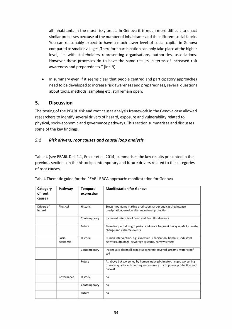
34
all inhabitants in the most risky areas. In Genova it is much more difficult to enact
similar processes because of the number of inhabitants and the different social fabric.
You can reasonably expect to have a much lower level of social capital in Genova
compared to smaller villages. Therefore participation can only take place at the higher
level, i.e. with stakeholders representing organisations, authorities, associations.
However these processes do to have the same results in terms of increased risk
awareness and preparedness.” (int. 9)
In summary even if it seems clear that people centred and participatory approaches
need to be developed to increase risk awareness and preparedness, several questions
about tools, methods, sampling etc. still remain open.
5. Discussion
The testing of the PEARL risk and root causes analysis framework in the Genova case allowed
researchers to identify several drivers of hazard, exposure and vulnerability related to
physical, socio-economic and governance pathways. This section summarises and discusses
some of the key findings.
5.1 Risk drivers, root causes and causal loop analysis
Table 4 (see PEARL Del. 1.1, Fraser et al. 2014) summarises the key results presented in the
previous sections on the historic, contemporary and future drivers related to the categories
of root causes.
Tab. 4 Thematic guide for the PEARL RRCA approach: manifestation for Genova
Category of root causes
Pathway Temporal expression
Manifestation for Genova
Drivers of hazard
Physical Historic Steep mountains making prediction harder and causing intense precipitation; erosion altering natural protection
Contemporary Increased intensity of flood and flash flood events
Future More frequent drought period and more frequent heavy rainfall; climate change and extreme events
Socio-economic
Historic Human intervention, e.g. excessive urbanisation, harbour, industrial activities, drainage, sewerage systems, narrow streets
Contemporary Inadequate channe[l capacity; concrete-covered streams; waterproof soil
Future As above but worsened by human induced climate change ; worsening of water quality with consequences on e.g. hydropower production and harvest
Governance Historic na
Contemporary na
Future na

35
Drivers of exposure
Physical Historic Intense agricultural practices and reduction of forest/wood areas; lack of or inadequacy of protection works
Contemporary Protection works and risk mitigation stalemate
Future As above
Socio-economic
Historic Urbanization, demographic growth (until 1970), lack of harmonization between urban and risk planning, culture of post-event ad-hoc funding and interventions, criteria for funding distribution penalising the region, lack of homogeneous and comparable criteria to assess risk levels in different regions
Contemporary Urbanization in areas protected by structural measures (but not 100% safe), lack of dataset/overview of allocated and transferred funding
Future As above and lack of harmonization between urban and risk planning
Governance Historic
Contemporary Inadequate/lack of human resources; excessive number of authorities; complex bureaucratic procedures and legal trials
Future Challenges posed by online communication flows, social media management and private weather forecast services
Drivers of
vulnerability
Physical Historic Inadequate water canalization, poor cleaning of streams’ and rivers’ beds
Contemporary As above
Future (Expected lack) of household investment in private protection measures
Socio-economic
Historic People feel protected by defenses/protection works, expect high degree of safety
Contemporary Lack of alignment between economic/urban planning and development and risk maps, Inadequate human resources (lack of personnel)
Future Population ageing, immigration, gender and place of residence as main social vulnerability drivers
Governance Historic Since the late 1990s decentralization of powers to regional and local authorities did not imply more funding at local level
Contemporary Legal conflicts blocking the use of (already) limited monetary resources as well as project implementation; too much responsibility at local level/too little capacities and resources; anti-corruption measures slowing down the system; excessive number of authorities
Future
Here below the most critical root causes of risk/ causal loops identified thanks to the desk study and the interviews are presented:
1. A long term root cause of risk in Genova is definitely excessive urbanization. Over
time, the rate of buildings along and over watercourses in Genova increased
significantly putting more lives and property at risk from potential flooding. The
increase in urbanized areas corresponded to a decrease in the land for forest.
Concrete-covered streams, inadequate urban drainage, narrow streets, and houses
acting as river banks worsened the situation. Moreover the well known conflict

36
between the guarantee of safety standards and urban/economic development seems
particularly relevant in Genova.
2. There have been extreme delays in enforcing planned structural protection works to
increase safety in the area surrounding the Bisagno river. These delays caused a risk
mitigation stalemate. The lack of action in implementing risk mitigation measures is
primarily attributed to delays in the transfer of the funding, which is –in turn- mostly
due to the legal conflicts related to the permits to build protection works. However
most interviewees agree that this is the short term cause of the stalemate.
3. A number of long term causes of this risk mitigation stalemate emerged, e.g. past
criteria for distribution of risk mitigation funding penalising the region; legal trials; a
dysfunctional legal system including more than 1300 norms regulating disaster risk
management in Italy; anti-corruption legislation having the perverse effect of slowing
down risk mitigation decisions; human and economic resource constraints especially
at the municipal level; mismatches between the political and disaster risk cycles;
excessive number of authorities involved in decision making processes; difficulties in
mainstreaming flood risk mitigation in regional policies. Yet, recent events in Genova
(especially 2014) also served as a catalyst for policy change at the national level. After
these events several actions have been undertaken in order to change risk reduction
policies: i) a new governmental “Unit” aimed at reducing hydrogeological risk (Unita’
di Missione contro il dissesto idrogeologico) was created; ii) the criteria for
distributing funding for risk mitigation among Italian regions changed (from number
of inhabitants/region size to risk levels, now comparable thanks to implementation of
European Flood Directive) (Regione Liguria 2014) iii) the “Unblock Italy decree”
(Decreto Sblocca Italia) which foresees new urgent measures to reduce
hydrogeological risks in Italian municipalities.
4. Another causal loop involves emergency management. Because of new technologies and the Internet, the distinction between official and un-official forecasts is sometimes blurry. This situation may cause a worrying decrease of trust in the authorities in charge of providing forecasts.
5.2 Methodological considerations for the next research phases
The analysis of the non technical aspects of risk management, including the risk drivers
affecting impact and outcomes and a root causes analysis proved to be a useful framework to
analyse the (often under-researched) social, economic and governance dimensions of risk.
In order to improve the RCCA framework in the next phases of PEARL, this section provides
some inputs based on the operationalization of RCCA and on the difficulties encountered
during the fieldwork.

37
First, it was difficult for the interviewees (and for the researcher performing the
interviews as well) to distinguish between the socio-economic and governance
drivers of exposure vs. vulnerability. The same is not true for the physical drivers,
also because of the technical nature of concepts such as hazard, exposure and
vulnerability. Therefore, to avoid conceptual misunderstandings and overlaps, it is
suggested that the distinction between hazard, exposure and vulnerability is not
made, at least with respect to the governance and socio-economic
dimension/pathways. Especially the distinction between the governance drivers of
exposure and vulnerability proved problematic.
Second, the distinction between the descriptive and normative/prescriptive
dimension in RCCA is not always clear. For example there are laws, statistics and
economic data available for the allocation of funding for risk mitigation, but there are
different opinions on what drove economic vulnerability to flood risk in Genova in the
past 30 years. An analysis focused on root causes leaves limited space (excluding the
background at the beginning) for description of these aspects. RCCA analysis is mostly
based on interviewees’ opinions about the drivers and root causes of risk. These
opinions can significantly differ, depending on the interviewees, their perspectives,
interests, values and responsibilities concerning flood risk management. Therefore it
is very important that the researcher acknowledges and is aware that the opinions of
certain stakeholders’ groups (e.g. those working for the agencies in charge of risk and
emergency management vs. residents) are not neutral and reflect a distinct
perception of what risk is and how it should be reduced. Therefore dealing with
stakeholders “perceptions and values” in a separate section, as suggested in the RCCA
methodology in Del. 1.1, can be misleading because the entire RCCA analysis is based
on perceptions and values.
Third, and partially related to the previous point, the distinction between issues
pertaining to the socio-economic, governance, perception and values dimensions is
also not always easy to trace. An example: the risk context in Genova highlighted a
very complex interaction between governance and social issues that makes very
difficult to separate these topics. Economic, governance and socio-economic
processes are very often strongly interlinked and it is difficult to separate them. For
example: the fact that legal controversies stopped the transfer of monetary resources
to build risk mitigation measures could be part of the economic or governance
pathway. Or: a wood which is less controlled results in missing water canalisations
and the poor cleaning of the streams’ and rivers’ bed: is this part of the physical or
socio-economic pathway or both?
Fourth, the distinction between contemporary and future drivers proved also
sometimes difficult, especially considering that results were mostly based on
qualitative interviews. Therefore asking interviewees to imagine e.g. “future
governance vulnerability drivers” proved sometimes difficult (and also had to be
explained e.g. to a member of a local NGO, without expert knowledge on
vulnerability).

38
In conclusion the RCCA framework proved extremely useful to identify drivers of risk and root
causes that usually do not emerge with other methodologies such as risk analysis, hazard, risk
and vulnerability assessment or even social vulnerability assessment, etc. It provided an
overview of critical issues for risk reduction in Genova, by allowing us to identify long and
short term drivers using a multi and interdisciplinary approach. In particular, the distinction
between short and long term causes of risk proved effective as a dimension for analysing
“historical /deeply rooted” vs. “contemporary/recent” risk issues and problems. The former
prove more difficult to change than the latter.
5.3 New ideas from and for practitioners
The purpose of this final section is to review the concepts, ideas, tools and approaches
discussed with practitioners and interviewees throughout the fieldwork and highlight some
new ideas for incorporating the results of RCCA into research and practice. Much progress has
been made toward reducing risk and building resilience in Genova, but much remains to be
done.
Interviewees mention several new ideas to be developed in the research and or practice
sector, such as:
1. social vulnerability mapping. Individual and household vulnerability maps are under
development thanks to questionnaire surveys that local authorities will administer in
2015. The results are expected to better inform emergency management (in parallel
with the implementation of the new municipal emergency plan, also to be enacted in
2015). This approach will provide measured indicators. Yet several interviewees agree
that it should be combined with a participatory approach aimed at supporting
community self-empowerment to generate change. Schools and local NGOs and
association are the best starting point to start this process.
2. development of personalised/individual emergency plans. These plans should
include not only the development of a smart phone application to issue an alert, but
also give residents the opportunity to know what to do and where to go depending
on where they live and work (and ideally where they are during and after the disaster).
Yet, key challenges are to clearly identify the residents’ preferences concerning
information provision: who should provide, what information to whom and when. The
understanding of the on-line and off-line official communication flows seems a
particularly delicate issue. Some EC funded projects (EURAMET) are already working
on developing innovative tools and apply them to the case of Genova.
3. overview of funding for disaster risk reduction. Funding for risk mitigation has been
allocated by different authorities acting at different levels, from European to national,
regional, provincial and municipal levels and working in different sectors, such as
urban planning-technical offices, environmental agencies, civil protection. A dataset
providing an overview is missing.
39
References
Burby R., French S. (1981) “Coping with Floods: the Land Use Management Paradox”,
Journal of the American Planning Association, 47, 3: 289-300.
CRUE-Eranet (2010) CRUE-Snapshot: Highlighting flood related research across
Europe, http://www.crue-eranet.net/
De Marchi B., Scolobig A., Delli Zotti G., Del Zotto M. (2007) Risk construction and
social vulnerability in an Italian Alpine Region, Report T11 - 07 - 12 of
FLOODsite Integrated Project, European Commission 6th Framework
Programme http://www.floodsite.net
Faccini F., Luino A., Sacchini A., Turconi L. (2015) Flash flood events and urban
development in Genoa Italy: lost in translation, in Lollino et al. (eds.)
Engeneering geology for society and territory, Vol. 5, Springer, Switzerland.
Fraser A., Pelling M. (2015) PEARL project Deliverable .1.1.
Galderisi A., Menoni S. (2007) Rischi naturali, Prevenzione e Piano, Urbanistica 134.
Galderisi A., Ceudech A. (2009) La mitigazione del rischio idrogeologico attraverso gli
strumenti ordinari di governo delle trasformazioni urbane: il caso del quartiere
Soccavo a Napoli, in Treu M.C. (ed.) Città, salute, sicurezza – Strumenti di
governo e casi studio – La gestione del rischio, Maggioli Editori: 474-502.
Monti A., Chiaves F. (2006) Italy, in Faure M., Hartliey T. (eds.) (2006), Financial
compensation for victims of catastrophes, Springer, Vienna, 145-194.
OECD, Organisation for Economic Cooperaion and Development (2009) International
futures project on risk management policies, Review of the national Civil
Protection System (Italy), OECD publishing,
http://www.oecd.org/publishing/corrigenda.
Rosso R. (2014) Bisagno. Il fiume nascosto Marsilio, Venezia
Veltri M. (2004) Profili istituzionali e scientifici della difesa del suolo Editoriale Bios,
Cosenza.

40
Annex
Stakeholder mapping
Key actors involved in flood risk management in Genova
Interviewee list
Most interviewees agreed only for their organisation to be cited to guarantee anonymity of
the interviews.
Interviewee 1: Regional Civil Protection Functional Center (Warning and Alarm)
Interviewee 2: Regional Coastal Ecosystem & Water Cycle Management Team
Interviewee 3: International Center on Environmental Monitoring
Interviewee 4: University 1 Professor
Interviewee 5: Municipal Civil Protection
Interviewee 6: Municipal Urban Planning Office
Interviewee 7: University 2 Professor
Interviewee 8: Municipal Communication Office
Interviewee 9: Sustainable Education and Citizen Participation Office
Interviewee 10: Flood Protection Voluntary Organisation
Interviewee 11: Regional Environmental Agency
Interviewee 12: Italian Environment Ministry
Interviewee 13: National Civil Protection
Interviewee 14: River Basin Authority Secretary
Interviewee 15: Lawyer specialised in flood risk issues
Interviewee 16: NGO 1 member
RegionallevelNa onallevel
Environment,Interior,and
otherMinistries,CivilProtec onDepartment,MajorriskCommission
Func onalandCompetenceCenters
Civilprotec onservice,firebrigadecorps,forestalcorps,policeandarmedforces,healthservices,technicaldepartmentsandagencies,meteorologicalservice
Professionalordergroupsandprivateconsultants,insurancecompanies,voluntarygroups
ResidentsMayor
Prefect
Provinciallevel
Municipallevel

41
Interviewee 17: NGO 2 member
Interview protocol
Introductory information
The research forms part of the PEARL project, or Preparing for Extreme and Rare Events in
Coastal Regions. This is an EC funded project taking place from 2014-2018, co-ordinated by
the UNESCO-IHE Institute for Water Education, The Netherlands but involving many partner
organisations across Europe. The aim is to support the development of strategies for coastal
flood management using a multi-disciplinary approach. Findings from the project will inform
a guidebook for flood management practitioners in the EU and beyond. More information
about PEARL can be found here: http://www.pearl-fp7.eu/about-pearl/
General objectives
Researchers at King’s College London and the University of Stuttgart lead a team of social
scientists who are undertaking a study of the economic, social and institutional causes of
risk and disasters in a number of EU and international case studies. The aim is to better
understand:
the social causation of small scale but high local impact disaster events in coastal
regions;
the causes and impacts of risk (for affected groups or individuals= through the lens
of a specific event or events)
The findings will inform a number of publications as well as the development of holistic risk
assessment models within PEARL. Anna Scolobig is in charge of collecting data for the
Genova case study on behalf of King´s College. The events under study are the 2011 (and
partially 2014) flash floods.
Please note that the protocol here below is a re-elaboration and adaptation of a protocol
provided by King’s College.
Questions
Event
What were understood to be the immediate, proximate causes of the disaster of the
initiating events?
Was the event forecast or predicted?
Was the existing knowledge available and accessible? Were there any decision-makers
who were unaware of the information (or less aware than they might have been)?
How was the risk of this event perceived and understood by all the categories of
stakeholders?
What strategies, laws, policies or measures had been considered to prevent the impact of
the event or reduce its consequences? Were any options rejected? To what extent had

42
strategies, policies or measures actually been implemented and put in place? Were they
effective? How and to what extent?
What was the economic/social status of the community immediately before the event
and how did it change subsequently? Was there any sense of unfairness or discrimination
in the community before, during or after the event? Are there contrasting or conflicting
views?
Causal analysis
What were the critical transitions in recent history (preconditions) that increased and changed the distribution of impact?
How did economic and political status influence the disaster risk? How did culture and societal norms influence the disaster risk?
What were the drivers of disaster prevention/resilience by broad categories: social characteristics, economic activity and livelihoods, levels of investments that reduced risk, institutional and governance structures, environment, infrastructure (critical infrastructure and residential environments), community competence (including prior experience with events, social cohesion, and social networks).
Were there barriers to disaster risk reduction? If yes, what were they?
Risk management
How are you/is your organisation dealing with the risks of floods in Genova and/or Liguria region (depending on the organisation and its mandate)? What kinds of prevention and mitigation measures are at place? What kinds of precautions have been taken to ensure people and buildings? What has been the number one concern and priority in risk management? What will be number one concern and priority in the future?
Does the local administration have the capacity to deal with flood risk? How could this capacity be improved? What do you think are the current constraints in managing flood risk?
Are there regional guidelines for flood risk management? Do you have access to them? Do you apply them? What are your views on the support received from regional and national levels for risk identification, communication and management? Is it adequate? If not then what more needs to be done?
Do you think that the funding for risk management is enough? Is there a fair distribution of funding for structural and non-structural measures/ among towns in the Liguria region/ among Italian regions?
Do you think there are any legal conflicts related to flood risk management? Did recent legislation enacted after the 2011 and 2014 events contribute in changing the situation? If yes, how?
Risk mapping

43
How are the basin plans and the watershed plans implemented in practice?
What, in your opinion, is the main purpose of mapping flood risk? How will the maps
translate into policy? What scale is appropriate for what kinds of uses?
Who will make most use of the maps, and what problems might arise?
What do you think about the availability of this data/services? How easy are they to
use/understand? What challenges/problems do you encounter in the use of the maps?
Warning systems and emergency management
Does the local administration have the capacity to deal with emergencies? How could this
capacity be improved? What do you think are the current constraints in managing
emergencies?
Are there regional guidelines and municipal plans for emergency management? What are
your views on the support received from regional and national levels for risk identification,
communication and management? Is it adequate? If not then what more needs to be
done?
Do you think that the funding for emergency management is enough? What have been
the priorities in the past and what will be the priorities for the future? Why?
How do you/your organisation deal with the scientific (but also legal and social)
uncertainty related to the warning system and emergency management?
Do you think that citizens are well prepared? How could they be better prepared? What
is the role played by new technologies and social media in emergency management? How
is it changing? Should responsibility for emergency management be reallocated? How?
Should better communication protocols be prepared? How?
Risk awareness, citizens’ involvement and participation in risk and emergency management
How do you think the locals respond to the risk – has it changed over the years? In what
way has it changed your practice and sense of risk? Do you think that you have a good
information and training on how to deal with the danger of floods?
In your opinion, is the public aware of flood risk? Do you think they trust the public
authorities to protect them against this risk? Are there environmental groups or citizen
groups that advocate for more protection? What is the role of the political parties? What
kinds of conflicts among the stakeholders have arisen?
Are citizens responsible for any aspects of risk mitigation or emergency management?
Should they be? How do they participate in the decision making process?
What role did the European Flood Risk Directive play (if any) in improving stakeholder
engagement in flood risk management?