Risk Assessment and Management for Offshore Geohazards · (NORSOK, 2001), ISO 17776:2000E (2000)...
16
ISGSR2007 First International Symposium on Geotechnical Safety & Risk Oct. 18~19, 2007 Shanghai Tongji University, China Risk Assessment and Management for Offshore Geohazards F. Nadim and T.J. Kvalstad International Centre for Geohazards / Norwegian Geotechnical Institute, Oslo Norway ABSTRACT: The state-of-the-art in understanding offshore geohazards has advanced significantly in the past decade. The advances have been mostly driven by the needs of the offshore petroleum industry. The pace of exploration and field development on the continental slopes and in ultra-deep waters worldwide has increased rapidly during the past decade. Activities are concentrated in areas where the sediment thickness is high and accompanied by diapirism and overpressured formations, requiring the offshore petroleum industry to understand and quantify the risk associated with various seafloor geohazards. An increasing number of observations of seabed instabilities, often on slopes with very low inclination, is of concern to the oil industry. The size of the affected areas range from small surficial slumps to enormous retrogressive slide events. The latter may affect field development areas several kilometres upslope as well as downslope of a slide initiation area. Rapid sediment deposition may generate excess pore fluid pressures, resulting in overpressured formations, and reduced sediment strength. This may lead to increased faulting, diapirism and fluid flow processes, with possible impact on local seabed inclination and seabed instability. On the continental slopes, the pore pressure distribution is a key factor in assessment of slide risk. Natural overpressured formations also represent a drilling hazard regarding shallow gas and shallow water flow. The understanding of the geological processes that create hazardous conditions, the geomechanical explanation of observed instabilities, the dating of these events and the evaluation of present and near future conditions are key elements in geohazard investigations. Likewise, human-induced changes have to be understood and evaluated with respect to their risk potential. Geohazard risk assessment is an integral part of the overall risk assessment in offshore oil and gas projects. The assessment of the risk associated with submarine mass movements is thus not just a matter related to commercial interests of oil companies. The societal and environmental consequences of such events could also be enormous for coastal communities. For instance, large submarine slides may generate tsunamis with potential for severe damage along the coastlines. Risk assessment for offshore geohazard requires a systematic search for potentially dangerous scenarios and associated consequences, followed by quantitative assessment of the likelihood of occurrence and vulnerability of the elements at risk. 1 INTRODUCTION Offshore geohazards comprise a number of geological phenomena, such as submarine slides, shallow gas and dissociation of gas hydrates, shallow water flow, mud volcanism, and seismicity (Fig. 1). Of these, the most serious is submarine sliding, which not only has an immediate effect on any seafloor installation in and downstream of the slide scar, but also may have serious third- party consequences if the slide has tsunamigenic potential. Hydrocarbon exploration and exploitation have, over the last decade moved into increasingly deeper waters of the world’s continental margins. This also means it has moved into increasingly more slide-prone areas. At the same time, the tools for detailed seafloor investigations have developed immensely, and new areas are mapped at great detail. This again has led to the discovery of submarine slides of various sizes in all margin areas of the world. The seafloor mapping in combination with high resolution seismic surveys reveal that widespread submarine sliding is not a recent phenomenon, and has always been an important process for sediment 159
Transcript of Risk Assessment and Management for Offshore Geohazards · (NORSOK, 2001), ISO 17776:2000E (2000)...
ISGSR2007 First International Symposium on Geotechnical Safety & Risk Oct. 18~19, 2007 Shanghai
Tongji University, China
Risk Assessment and Management for Offshore Geohazards F. Nadim and T.J. Kvalstad International Centre for Geohazards / Norwegian Geotechnical Institute, Oslo Norway ABSTRACT: The state-of-the-art in understanding offshore geohazards has advanced significantly in the past decade. The advances have been mostly driven by the needs of the offshore petroleum industry. The pace of exploration and field development on the continental slopes and in ultra-deep waters worldwide has increased rapidly during the past decade. Activities are concentrated in areas where the sediment thickness is high and accompanied by diapirism and overpressured formations, requiring the offshore petroleum industry to understand and quantify the risk associated with various seafloor geohazards. An increasing number of observations of seabed instabilities, often on slopes with very low inclination, is of concern to the oil industry. The size of the affected areas range from small surficial slumps to enormous retrogressive slide events. The latter may affect field development areas several kilometres upslope as well as downslope of a slide initiation area. Rapid sediment deposition may generate excess pore fluid pressures, resulting in overpressured formations, and reduced sediment strength. This may lead to increased faulting, diapirism and fluid flow processes, with possible impact on local seabed inclination and seabed instability. On the continental slopes, the pore pressure distribution is a key factor in assessment of slide risk. Natural overpressured formations also represent a drilling hazard regarding shallow gas and shallow water flow. The understanding of the geological processes that create hazardous conditions, the geomechanical explanation of observed instabilities, the dating of these events and the evaluation of present and near future conditions are key elements in geohazard investigations. Likewise, human-induced changes have to be understood and evaluated with respect to their risk potential. Geohazard risk assessment is an integral part of the overall risk assessment in offshore oil and gas projects. The assessment of the risk associated with submarine mass movements is thus not just a matter related to commercial interests of oil companies. The societal and environmental consequences of such events could also be enormous for coastal communities. For instance, large submarine slides may generate tsunamis with potential for severe damage along the coastlines. Risk assessment for offshore geohazard requires a systematic search for potentially dangerous scenarios and associated consequences, followed by quantitative assessment of the likelihood of occurrence and vulnerability of the elements at risk.
1 INTRODUCTION
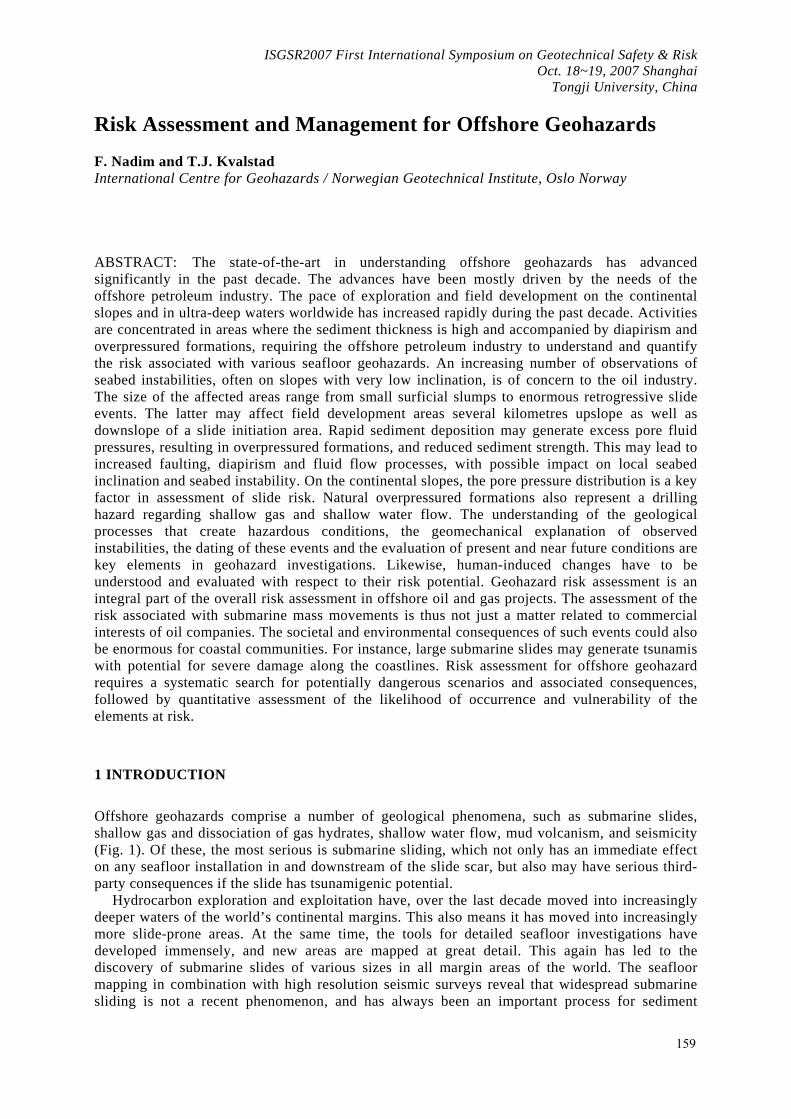
Offshore geohazards comprise a number of geological phenomena, such as submarine slides, shallow gas and dissociation of gas hydrates, shallow water flow, mud volcanism, and seismicity (Fig. 1). Of these, the most serious is submarine sliding, which not only has an immediate effect on any seafloor installation in and downstream of the slide scar, but also may have serious third-party consequences if the slide has tsunamigenic potential.
Hydrocarbon exploration and exploitation have, over the last decade moved into increasingly deeper waters of the world’s continental margins. This also means it has moved into increasingly more slide-prone areas. At the same time, the tools for detailed seafloor investigations have developed immensely, and new areas are mapped at great detail. This again has led to the discovery of submarine slides of various sizes in all margin areas of the world. The seafloor mapping in combination with high resolution seismic surveys reveal that widespread submarine sliding is not a recent phenomenon, and has always been an important process for sediment
159
transport on continental margins. Submarine slides can be triggered by natural geological processes or by human-induced changes. Large scale, long-term geological processes need to be understood and incorporated in petroleum exploration activities and are often of vital importance for geohazard evaluations. On a global basis, plate tectonics controls the development of continental shelves and margins. Long term environmental changes with a period of about 100,000 years caused major glaciations repeatedly during the last 900,000 year. The shift between the interglacial sea level high-stand and the glacial sea level low-stand periods, with more than 100 m change in the sea level, have had a significant impact on the development of continental shelves and slopes (Solheim et al., 2007).
Fig.1 Potential geohazards on deepwater margins.
2 CHARACTERISTICS OF SUBMARINE SLIDES
Submarine slides are common and very effective mechanisms of sediment transfer from the shelf and upper slope to deep-sea basins (Hampton et al., 1996; Locat and Lee, 2002; Syvitsky et al., 1987). During one single event enormous sediment volumes can be transported on very gentle slopes with inclinations in the range 0.5 to 3°, over distances exceeding hundreds of kilometres. Typically such events last from less than an hour to several days and can severely damage fixed platforms, pipelines, submarine cables and other seafloor installations. Research on understanding the mechanisms behind and the risks posed by submarine slides has intensified in the past decade, mainly because of the increasing number of deep-water petroleum fields that have been discovered and in some cases developed (Locat and Mienert, 2003). Production from offshore fields in areas with earlier sliding activity is ongoing in the Norwegian margin, Gulf of Mexico, offshore Brazil, the Caspian Sea and West Africa.
Submarine landslides occur frequently on both passive and active continental margins, especially on the continental slopes. Despite the generally low slope angles, these are areas of sloping stratigraphy, often with more active and vigorous geological processes, including seismicity, than those found in the shallow, sub-horizontal continental shelf areas. The shelf edge and slope area contain the most recently deposited materials, and in areas with high deposition rate, underconsolidation / excess pore pressure may exist. The excess pore pressure often plays a major role in destabilization of submarine slopes. The expenses of finding and developing new fields in deep water are very high, and this greatly increases the economic consequence part of the risk aspect connected to submarine slides in the continental margin settings.
The assessment of the risk associated with submarine mass movements is thus not just a matter related to commercial interests of oil companies. The societal and environmental consequences of such events could also be enormous for coastal communities. For instance, large submarine slides
160
may generate tsunamis with potential for severe damage along the coastline. The tsunami generated by the earthquake-triggered Grand Banks slide in 1929 killed 27 people in Newfoundland. The 15-m tsunami that killed more than 2000 people in Papua New Guinea in 1998 was also caused by an earthquake-triggered submarine slide.
3 RISK ASSESSMENT FOR OFFSHORE GEOHAZARDS
The first challenge that most geo-scientists involved in any kind of risk evaluation are faced with is to clarify or understand what is meant by “risk” and “risk assessment”. The International Society of Soil Mechanics and Geotechnical Engineering (ISSMGE) Technical Committee on Risk Assessment and Management (TC32) developed a Glossary of Terms for Risk Assessment (http://www.engmath.dal.ca/tc32). The terminology recommended by ISSMGE is generally followed in this paper. Quantitatively, risk is defined as the measure of the probability and severity of an adverse effect to life, health, environment, property or reputation. Quantitatively, risk is the product of the hazard times the potential worth of loss and can be written as (Lacasse and Nadim, 2007):
R = H×C or R = H×V×E
where R is risk, H is hazard, C is consequence, V is vulnerability of elements at risk, and E is cost of total loss of elements at risk.
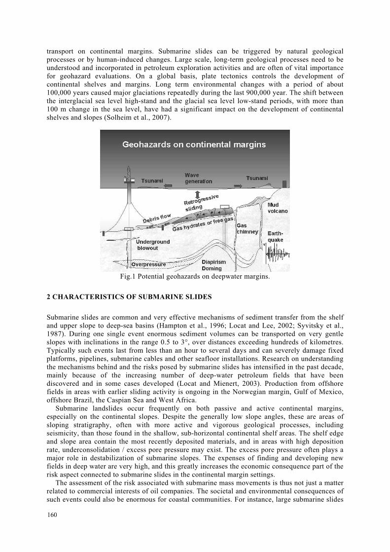
To date no specific industry standard exists for the assessment of risk associated with offshore geohazards. The NORSOK Standard Z-013 "Risk and Emergency Preparedness Analysis" (NORSOK, 2001), ISO 17776:2000E (2000) and API RP 14J (1993) provide descriptions of the principal tools and techniques for risk assessment in connection with offshore installations. These general requirements and recommendations can be transformed to more specific requirements for geohazards risk assessment (Fig.2).
The assessment of the risk posed by a potential submarine slide requires identification and analysis of the relevant failure scenarios, i.e. failure modes, triggering sources and related failure consequences, which have a significant contribution to the total risk. The triggering mechanisms could be natural, such as earthquake, tectonic faulting, temperature increase caused by climate change, excess pore pressure due to rapid sedimentation and gas hydrate melting due to climate change with increased sea water temperature after glacial periods; or man-made, such as anchor forces from ships or floating platforms, rockfilling for pipeline supports, temperature change around oil and gas wells in the offshore field development area, underground blow-out, and reservoir depletion and subsidence (including induced seismicity). The key issue in the slide risk assessment is the identification of potential triggers and their probability of occurrence, the associated failure modes and their consequences. Kvalstad (2007) recommended the following work tasks in offshore geohazards risk assessment:
-System definition. The spatial extent of a geohazard system must cover the potential influence zones of field installations and pipeline corridors. In addition the influence zone of natural hazards will have to be added. On slopes with signs of slope instability, the system might need to be extended to include large areas upslope and/or downslope of the field installations. In the vertical direction the geohazard system should cover soil and pore pressure conditions that might have a significant influence on the stability of seabed, foundations and wells.
-Identification of geohazards (GEOHAZID). The GEOHAZID describes potential failure scenarios that may affect human life, environment and assets caused by relevant triggering sources and possible damage or consequence. The GEOHAZID should be performed by an experienced interdisciplinary group composed of experienced geologists/ geophysicists, geotechnical engineers and relevant engineering specialists dependent on the types of geohazards and consequences involved.
-Risk estimation. The failure scenarios identified in the HAZID can be considered as systems of geomechanical failure modes, triggering sources (initiating events) and related failure consequences. Quantitative risk analysis (QRA) requires estimates of the frequency (typically as
161
annual probability) of occurrence of triggered events and assessment of the associated consequences.
The framework suggested by Kvalstad (2007) for geohazards risk assessment is depicted on Fig.2.
Fig.2 Geohazard risk analysis framework (Kvalstad, 2007)
4 SYSTEM DEFINITION
In time and space a geohazard risk system is composed of: - Local and regional geological and geotechnical site conditions. - Local and regional geological processes and human activities that may change these
conditions from a stable or labile situation into an unstable situation (i.e. the triggering of geohazard events).
- Location, extent and vulnerability of values (human life, environment and facilities) that potentially could be exposed to geohazard events either directly or by an escalation of the event.
In the early phases of a study the system definition is usually based on limited information. Gathering of existing local and regional background information about geography, geology, tectonics and historic hazard information from published literature, local authorities and institutions should be combined with information from previous investigations and projects in the area.
4.1 Project-specific informationThe local and regional background information have to be combined with data from the project-specific investigations, during exploration and field development planning, covering geophysical data, logs from exploration wells, seismic hazard assessment, geotechnical/geological boreholes for ground truthing and assessment of soil parameters as well as plans for production wells and
162
field lay-out. The information must be evaluated and processed further to derive quantitative geological, geomorphological and geotechnical models of the system from seabed to reservoir depth. In this way seabed and subseabed features, ongoing geological processes and soil conditions that may influence the stability of wells, seabed and foundations, can be mapped and quantified (Fig. 5).
The interpretations require tools and methodologies ranging from seismic processing systems to geotechnical finite element analysis of compaction, pore pressure conditions and slope stability. The amount of data increases during project development and would require effective visualisation tools.
The interpretation and evaluation of available data will inherently include uncertainties, which are dependent on the penetration depth of the investigation tools, the density and resolution of the sampled data and positioning accuracy.
4.2 Bathymetry and seabed features Global or large scale maps may give a first impression of the location relative to major geographic/geological features like major rivers and their drainage area, deltas and deep-sea fans, extension of continental shelves and slopes. In frontier areas there is normally a lack of detailed bathymetric data. The publicly available databases ETOPO2 (Smith et al., 1994) with a 2 grid and GEBCO (2003) with a 1 grid are based on satellite altimetry data calibrated against ship track bathymetry, and can be used for plotting maps for selected areas in an early phase of a project and general overviews.
3D seismic surveys will provide substantially improved details of the local bathymetry within the surveyed area. Today’s bathymetric surveys are normally carried out as swath bathymetry using multi-beam echo sounder systems, mounted on ships. The accuracy will decrease with increasing water depth due to beam spreading and increased footprint. However multi-beam echo sounders mounted on underwater vehicles (towed or autonomous) may deliver nearly photo-sharp information about the seabed bathymetry in deep water areas. Experience from recent and ongoing geohazard studies show that detailed bathymetric mapping of the investigated system is invaluable in the evaluation of the geohazard risk and for the planning of risk analysis and site investigations. Autonomous underwater vehicles (AUVs) can operate to 3000 m water depth, and in the near future 4500 m systems will be released.
Side scan sonar (SSS) surveys provide information about seafloor morphology and reflectivity (backscatter), and are useful for identification of seabed hard ground, pock marks and active gas seeps, as well as debris like ship wrecks, lost fishing gear, anchor cables, drill pipe, etc.
4.3 Seismic profiling Towed streamer seismic surveys may give a good penetration depth and cover large areas effectively. However the vertical resolution is a function of the seismic wave length. Typically a 3D survey for exploration purposes may have a penetration depth of about 5 km and resolution of about 12 m in the upper hundred metres of sediments, while an ultra high resolution (UHR) 2D survey may penetrate less than 1000 m and have a vertical resolution of about 4 to 5 m. This will allow identification of larger features and slide areas as well high amplitude reflections (bright spots) indicating free gas. However, smaller slumps, slides, pockmarks and seeps that may represent a hazard for subsea structures and pipelines may not be identified clearly. Bottom towed AUVs for ultra-ultrahigh resolution have a restricted penetration ability and may possibly penetrate 50 to 100 m below seabed, but have vertical resolution of about 0.5 m.
Seismic profiling allows identification of palaeo slide activity. Buried marine transport deposits (MTDs, i.e. slide material) and slide scars show the preferred glideplanes, and dating of the infill sediments on top of the MTDs may reveal age and cyclicity of slide activity that could be related to sea level and climate variations. Salt and mud diapirs, mud volcanoes, deep-seated faults and faults to the surface can be identified. Combined with dating of the major seismic horizons the displacement rate of active faults and diapirs can be estimated.
163
4.4 Gassy soils and gas hydrates Gassy soils have a low compression modulus and tend to absorb the wave energy from compression waves (P-waves). This leads to gas blanking on the seismic profiles and makes the identification of seismic horizons difficult. Shear waves are not affected significantly by free gas, and the use of seismic shear waves is a possible way to overcome gas blanking. Shear wave generators have been developed, and it is expected that equipment and techniques for a more streamlined application of shear wave seismics will develop during the next few years (Westerdahl et. al., 2007).
Gas hydrates (GH) are ice-like crystals of gas molecules encaged in an ice crystal structure of water molecules. Gas hydrates are stable above a certain pressure and below a certain temperature. Methane is the most common natural gas in sediments and thus the most common hydrate former. Typically methane hydrate will form in sediments below 300 to 500 m water depth. The base of the hydrate stability zone depends on the local geothermal gradient.
At the base of the gas hydrate stability zone (GHSZ) free gas may form when methane hydrate dissociates. Since the depth of the base of the GHSZ depends on the pore water pressure and temperature, the base of the GHSZ can be seen as a reflector following the variations of the seabed, but diving deeper with increasing water depth. This reflector is called a Bottom Simulating Reflector (BSR) and can be an indicator of gas hydrate in the sediments above the BSR. However, a BSR is not a proof that GH exist. GH in sufficient concentration may partly cement the sediments, and this may affect the P-wave and S-wave velocities. Attempts have been made to quantify the GH saturation level based on observed velocity changes. However, the uncertainty in such indirect interpretation is considerable, and direct measurement by sampling is recommended.
5 GEOTECHNICAL/GEOLOGICAL SITE INVESTIGATIONS
The focus of geohazard soil investigations should be directed towards providing data that can help to explain observed instabilities and anomalies and be used in a quantitative assessment of the geohazard risk of the present situation and how it is influenced by field development activities. The seismic stratigraphy is based on interpretation of P- (and possibly S-) waves and will in a new area be affected by uncertainty with respect to nature and properties of the different strata. In order to reduce the uncertainty and to assess quantitatively the properties of the strata, soil sampling and testing programs are required.
Geotechnical/geological coring from seabed can cover the upper 5 to 30 m, and in situ tests like field vane and cone penetration tests may reach depths of 50 m in soft soils. Drilling of boreholes from specially equipped vessels allows soil samples to be taken and downhole field testing like cone penetration tests (CPTs) and field vane tests to be carried out. The limiting water depth of commercial geotechnical drilling vessels is presently at 3000 m. The borehole depth may vary from a few tens of metres to several hundred metres dependent on the identified objective, but also on the vessel's equipment.
Wireline logging of the boreholes will cover gaps in the field tests and sampling records and provide more continuous data profiles.
It is vital to have control on the in situ pore pressure conditions for assessment of slide risk and sea bed stability and also for planning and execution of laboratory test programmes. Direct measurement of the pore fluid pressure is possible with different kinds of piezometer devices. However, the disturbance caused by inserting the piezometer device into the soil generates a change in pore pressure conditions. In fine grained soils typical for deepwater offshore conditions, dissipation of the disturbance takes time, which is turn is dependent on the size of the disturbed zone. Specially designed thin piezoprobes have been developed to reduce the time required for dissipation to in-situ pore pressure. The time required to get reliable measurements of the in situ pore pressure is often more than 6 hours, and sometimes considerably longer.
The hourly cost of a geotechnical drilling vessel is high, and alternative solutions with push in piezometers and piezometers installed in boreholes were applied in the Ormen Lange project (Strout and Tjelta, 2007). Recently multilevel piezometers have been developed that are equipped
164
with data loggers that can record pressure over long time and dissipation time is thus not a problem. The data loggers can be picked up by ROVs in a later survey of the area. Further, these instruments use differential pressure transducers, which improve the resolution and accuracy in deep water conditions considerably (Strout and Tjelta, 2007).
In areas where gas hydrate may exist, measurement of temperature distribution vs. depth, i.e. water temperature at seabed level and the thermal gradient, is required for assessment of the hydrate stability zone and potential effects of heat flow from wells and flowlines/pipelines. Determination of thermal properties of the sediments might be required for evaluation of heat flow around wells and structures in connection with hydrate dissociation.
Pressure coring is required to preserve samples containing gas hydrate. This is not standard for geotechnical site investigations. Specialised equipment has been developed in connection with the ODP/IODP scientific investigations of gas hydrate locations like Blake Ridge and the Hydrate Ridge. However, monitoring of sample temperature immediately after sampling and chlorinity distribution of the pore water may give a good indication of presence or lack of gas hydrates. If gas hydrate is present, considerable sample cracking and disturbance due to gas expansion and uneven water content distribution should also be expected when the samples undergo pressure relief of more than 30 bars.
In areas where excess pore pressure exists, the field test will be performed under the correct in situ effective stress conditions, while reconsolidated laboratory test, like triaxial and direct simple shear tests, may be carried out at too high stress levels based on measured unit weights and water contents and assuming hydrostatic conditions.
Pore water salinity and clay mineralogy may influence material behaviour considerably and should be included in the laboratory test programme. It is important that laboratory testing is performed under controlled salinity conditions. Freshwater smectites have a very low residual friction angle, high porosity and high compressibility and are not representative for smectites with normal seawater salinity.
In areas with rapid sedimentation high pore pressures may develop. Analyses for prediction of pore pressure and effective stress conditions require quantitative data on sediment accumulation rate. The most important time period to consider in this connection is the Quaternary, i.e. the past 1.8 mill years. This is a period with fluctuating sea levels caused by the repeated waxing and waning of northern hemisphere glaciers in conjunction with climatic cyclicity.
The observed large scale slide events on glacial margins and in river deltas on slope angles less than 3° can only be explained by progressive and retrogressive failure models combined with excess pore pressure (Kvalstad et al., 2005). Marine, hemi-pelagic clays are strain-softening materials, which may loose a considerable part of the undrained shear strength when exposed to large shear strains; so called sensitive clays. The residual strength of marine clays (with salinity of about 30) can be as low as 15 to 30% of the peak strength, and is a central parameter in evaluation of progressive and retrogressive slide processes. The loss in strength is caused by increased pore pressure due to breakdown and reorientation of the mineral structure towards a denser configuration (contractive behaviour).
The remoulded strength is considered to be a lower bound value of the undrained residual strength of soil, and a sufficient number of tests should be carried out to define this strength parameter. Sleeve friction, fs, from CPTs (or a fraction of about 2/3 of fs) and remoulded field vane test data should be considered as well.
As the elevation and thickness of the identified strata and the pore pressure conditions may vary considerably over the area investigated, normalisation of soil parameters is normally required to enable extrapolation of information from boreholes to the overall area. Effective overburden stress has a significant influence on compression behaviour, permeability and strength of soils and is the preferred normalisation parameter. In areas where the sediments have been unloaded due to loss of overburden, i.e. the sediments are overconsolidated, the overconsolidation ratio should be added as a second normalisation parameter (Ladd and Foott, 1974). Normalisation of deformation and strength parameters will also enable a statistical treatment of data over large area and overburden depths.
Soil investigations in connection with geohazard assessment will often have to cover extensive areas. To reduce the uncertainty, it is recommended to compare normalised stiffness and strength
165
data with available soil databases. This also applies to classification and index data in order to identify anomalous material types and stress conditions. Boreholes are 1-dimensional and must be tied to the seismic stratigraphy from 2D and 3D surveys. Tie-lines between geotechnical boreholes and exploration wells are required for extrapolation of geotechnical/geological information from boreholes to the surrounding area, alternatively the boreholes should be placed at crossing points of seismic lines. Still information about sediment properties such as P-wave velocity, is needed for proper correlation, since seismic data are recorded in time and not in true depth in metres.
Strength anisotropy is an important factor in analysis of slope stability. The compressive undrained strength is generally higher than the direct simple shear strength and the extension strength is even lower. The anisotropy seems to be higher for low plasticity clays than for clays with high plasticity.
Stress-dependency should be evaluated and included in the evaluation of strength parameters. At shallow depth, i.e. low consolidation stress, the normalised strength is higher than at greater depths below seabed.
Strain rate has a significant influence on the undrained shear strength of marine clays and should be accounted for. The applied strain rate in laboratory tests (a few percent per hour) and the in situ strain rates under nearly static loading conditions and under wave loading and earthquake loading vary considerably and could differ by several orders of magnitude.
6 GEOHAZARD IDENTIFICATION – GEOHAZID
The identification of geohazards will require an evaluation of existing site conditions and assessment of the present or planned situation with respect to local and regional seabed stability and stability of wells, subsea structures, pipelines and platform foundations/anchor. The GEOHAZID is a systematic search for natural and human-induced processes and activities, i.e. triggering sources, which have a potential for transforming stable conditions into unstable conditions with harmful consequences. An expert team of experienced geologist, geophysicist and geotechnical engineers with ability to communicate across discipline borders is thus required to identify relevant failure scenarios and associated triggering mechanisms. The GEOHAZID team should be assisted by drilling and/or facilities engineers, and be guided by a risk analysis expert in order to systemize and rank the scenarios and triggers in a way that allows quantitative risk analysis (QRA) to be performed.
Geohazard failure scenarios are basically assumed realisations of potential geomechanical failure modes that may involve or affect field installations or 3rd party assets based on the available information and the knowledge, experience and intuition of the GEOHAZID team. Geomechanical modelling of the failure scenarios is required to evaluate the likelihood of occurrence and criticality in order to rank the different failure scenarios.
The category of failure scenarios involving local seabed instability are related to unacceptably large displacements causing damage or production restrictions to equipment installed on the seabed; typically reduction of vertical, lateral or rotational bearing capacity of mat supports, piles, wells or pipelines/flowlines. Local seabed deformations under or towards installations may occur due to changes in
- Bathymetry and seabed gradients (sedimentation, erosion). - Pore pressure conditions/fluid flow. - Soil strain-softening under increased static and cyclic loading. - Generation of fluid/gas flow under or close to foundations (Tjelta et al., 2007) - Temperature increase around wells, manifold structures and pipelines causing gas hydrate
melting followed by gas bubble expansion, fracturing and free water that will reduce the shear strength of the soil (Sultan, 2007).
- Cratering caused by blow-outs/uncontrolled gas and shallow water flow The category of failure scenarios involving mass transport initiated within field development
area comprises slumping and local sliding that affect installations either as loss of foundation area or as debris impact. Areas with increased gradient, caused by submarine channels, uneven
166
deposition or erosion, escarpments from previous slide events and active faulting, are more critical than the surrounding areas. Sea bed instability can be initiated by gradual over-steepening caused by diapirism, faulting, uneven deposition and erosion, or by other triggers like earthquakes and human-induced changes in pore pressure and loading conditions. Sensitive clays may lead to progressive failure and development of long compression zones in the toe area and tendencies to retrogression behind the crest.
In areas with long continuous slopes, the run out distance of submarine slides can be very long. Upslope slide events may develop to debris flows or generate extensive compression zones. When running into or crossing over parts of a field development area or pipeline corridor, there is a high potential for damage to structures and pipelines and total of partial burial of equipment. These slides can be triggered by wave pressure in the shelf edge area, earthquakes, over-steepening from deposition, erosion, faulting and human activities in licenses located upslope.
Retrogressive slides may escalate to enormous slide events and have been observed on glacial margins as well as on river delta areas. These slides may be triggered as a smaller slide event in the lower part of a delta or continental slope. Progressive failure combined with high mobility of the debris may generate retrogressive back-stepping processes over tens of kilometres and long run out distances of debris flows and tubidity currents.
The multidisciplinary HAZID team should ask and answer the following questions: - Can we explain observed instabilities, i.e. infer the past? - Can we link this to geological processes and past soil conditions (pore pressure
conditions)?- What are today's and near future natural hazards? - Can exploration, field development and production activities adversely affect the
conditions and increase the risk level? - Can field installations or 3rd party be affected?
A representative set of past, present and near future failure scenarios should be described and selected for further evaluation in order to explain the observed instabilities and anomalies in the area and gain confidence in the understanding of the geological processes, site condition and soil/pore pressure conditions; and to assess the likelihood/probability of future geohazard events, quantify the associated consequences and evaluate the geohazard risk.
The HAZID team should advise on missing and required information for the geohazard risk evaluation and communicate their findings to the field development project.
7 QUANTIFICATION OF RISK
Evaluation of the stability of slopes has traditionally been based on a deterministic approach where the level of safety is quantified by the safety factor. The factor of safety is defined as the ratio of the characteristic resisting force to the characteristic load (driving force). Many of the parameters that are used in a stability analysis, in particular the soil shear strength and the earthquake load effects (for seismic stability evaluation), are inherently uncertain. The uncertainties involved in assessment of site and soil conditions are in many cases amplified by the spatial extent and depth of the sediments and geological units involved, the presence of gas in sediments, and the practical and economical limitation of the site investigations. The conventional approach does not address the uncertainty in load and resistance in a consistent manner and is not well-suited for risk assessment. The ambiguous definition of “characteristic” values allows the engineer to implicitly account for uncertainties by choosing conservative values of load (high) and resistance parameters (low). The choice, however, is somewhat arbitrary. Slopes with nominally the same factor of safety could have significantly different probabilities at failure because of the uncertainties and how they are dealt with.
7.1 Frequency analysis/Failure probability Risk estimation requires the evaluation of the probable frequency of threats (i.e. slope instability leading to sliding activity) and the associated consequences. Data on submarine geohazard events are scarce and statistics are generally not available. Thus, the evaluation of event frequency
167
(hazard) in most cases has to be based on a combination of field observations, dating of earlier events and geotechnical analyses of the failure scenarios. Reliability theory and probabilistic analyses provide a rational framework for estimating the probability of slope failure and are powerful tools for quantitative risk assessment. However, reliability methods require more data and estimates of the variances in significant parameters. This can be expensive and it will also require expert judgment. The cost and judgment are part of the price paid for a better answer. Lacasse and Nadim (2007) summarise the most common tools for probabilistic slope stability evaluation, namely the first-order, second-moment (FOSM) approach, first- and second-order reliability methods (FORM and SORM), Monte Carlo simulation, and event tree analysis. Note that these methods aim at estimating the probability of failure (i.e. hazard), which is only one component of risk. Consequence analysis is just as important as the hazard estimation, and it sometimes involves even greater uncertainties.
The ideal solution would be probabilistic analysis of complete mechanical scenario models with full interaction between soils, structures, environmental and geological processes and load effects in space and time. This is not feasible in the foreseeable future, and the analyses have to be split in separate sequences with considerable simplifications and approximations.
The probabilistic slope stability analyses take into account the uncertainties within the system and provide an estimate of the probability that a system, if “built” today, would fail immediately. This is a straightforward interpretation for man-made slopes like earth dams and embankments. For natural slopes this interpretation is not relevant. As the slope has not failed today, its probability of “static” failure is zero, since as long as there are no triggers causing changes to the system, a slope that stands today would never fail. Therefore, the failure probability provided by the probabilistic slope stability analysis is not an indicator of the annual probability of failure for natural slopes.
Two types of triggering mechanisms typically to be considered in the slope stability evaluation for a submarine slope: rapidly acting triggers like earthquakes and wave loading, and slowly varying triggers like sediment deposition and fault or diapir displacements. The rapidly acting triggers are discussed and evaluated by Nadim et al. (2005), and the slowly varying type by Nadim et al. (2003) and Lacasse and Nadim (2007). Regarding the seismic triggering mechanism, Probabilistic Seismic Hazard Assessment (PSHA) provides site-specific earthquake load characteristics, like peak ground acceleration and response spectrum, vs. recurrence period. This allows a connection to be established between seismic load intensity and recurrence period, which again can be transformed to a relationship between recurrence period and post-earthquake strength reduction of the sediments, and finally to an annual probability of earthquake-induced failure.
When the occurrence frequency or the development rates of triggering sources are estimated, tectonic and climate changes must be taken into consideration. Glacial cycles with eustatic sea level variations have had a strong impact on sediment deposition rates on the continental slopes and formation of major river delta and glacial fan structures. Many of the major submarine slide events seem to be connected to these variations, and the present interglacial climate with sea level high-stand is generally associated with strongly reduced sedimentation rates along the deepwater margins. A reduction in sedimentation rate below a certain value will lead to a gradual reduction in excess pore pressure and thus a gradual improvement of slope stability. A comparison of slump rate vs. sedimentation rate was described for the drape sediments at Sigsbee Escarpment, Nadim (2003) and showed a clear reduction in slump rate with decreasing deposition rate.
7.2 Systematic approach to consequence estimation The potential consequences of the failure scenarios have to be estimated from an engineering point of view, as well as from health and safety, and economic points of view. A systematic compilation of estimated damage vs. estimated probability of occurrence is required for all identified failure scenarios to assess the cumulative geohazard risk. General techniques for risk evaluation (event tree and fault tree analyses, risk matrices etc.) can be applied.
Typical consequences are related to: - Loss of foundation support or capacity causing tilting, sinking, pull-out of piles, anchor
and mat foundations
168
- Structural damage to foundation elements, subsea structures and pipelines like shearing, buckling and bending, caused by impact from debris flow
- Damage to wells during drilling and production - Burial of installation in slide debris - Total collapse and large displacements of field installations located in major slide events
The run-out distance of debris flows and the cut-back distance of retrogressive slides are important factors in the consequence evaluation. There is considerable uncertainty related to the disintegration process of the slide debris from slide initiation to completed run-out. Intrusion of water in the slide mass or into the slip surface will increase the disintegration of the debris and the sliding resistance along the slip surface causing higher velocities and longer run-out distances. Debris disintegration is an area of ongoing research, but clear conclusions and recommendations are not yet available (Gauer et al., 2007).
Run-out and cut-back distance estimates have to be complemented with estimates of the lateral extension of the slide event. Numerical or analytical methods are generally 2-dimensional, and the width estimates will generally have to be based on observed slide geometries and the bathymetry in the area.
Installations located within the potential run-out or cut back zone of slides and debris flows should be designed to resist the impact and drag forces. Debris flow forces against cylindrical elements have been studied by Pazwash and Robertson (1975), Georgiadis (1991) and Shapery and Dunlap (1978). Most tests have been performed with low velocities and strain rates. Use of computational fluid dynamics (CFD) codes allows numerical evaluation and has been checked against static and dynamic test data (Zakeri, 2007). The drag force increases rapidly with increasing velocity and debris thickness, and debris resistant design of piles, wells and structural members of subsea installations is probably limited to relatively shallow failure events in soft clay drapes.
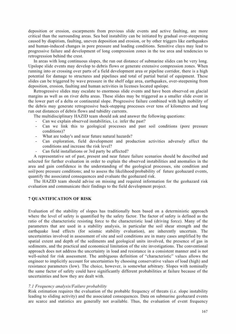
Fig.3 Location maps of the Storegga Slide and the Ormen Lange field.
Large scale slide events may generate tsunami waves (Harbitz et al., 2007). The wave height is dependent on the water depth and the volume and shape of the slide mass, and acceleration/velocity development. In deeper water the surface effects are limited and will generally not be critical for offshore platforms and vessels. With decreasing water depth towards shore, the wave height increases and can have devastating effects. The Storegga slide (Fig. 3), which occurred about 8200 years ago, created a tsunami that left deposits more than 10 m above sea level in western Norway and up to 20 m above sea level in the Shetland Islands (Bondevik et al., 2005). The consequence of this event was probably catastrophic for the coastal areas. Tsunami analyses can give an estimate of the sea level variations along the coastline and in the field area vs. slide characteristics (Løvholt et al., 2005).
169
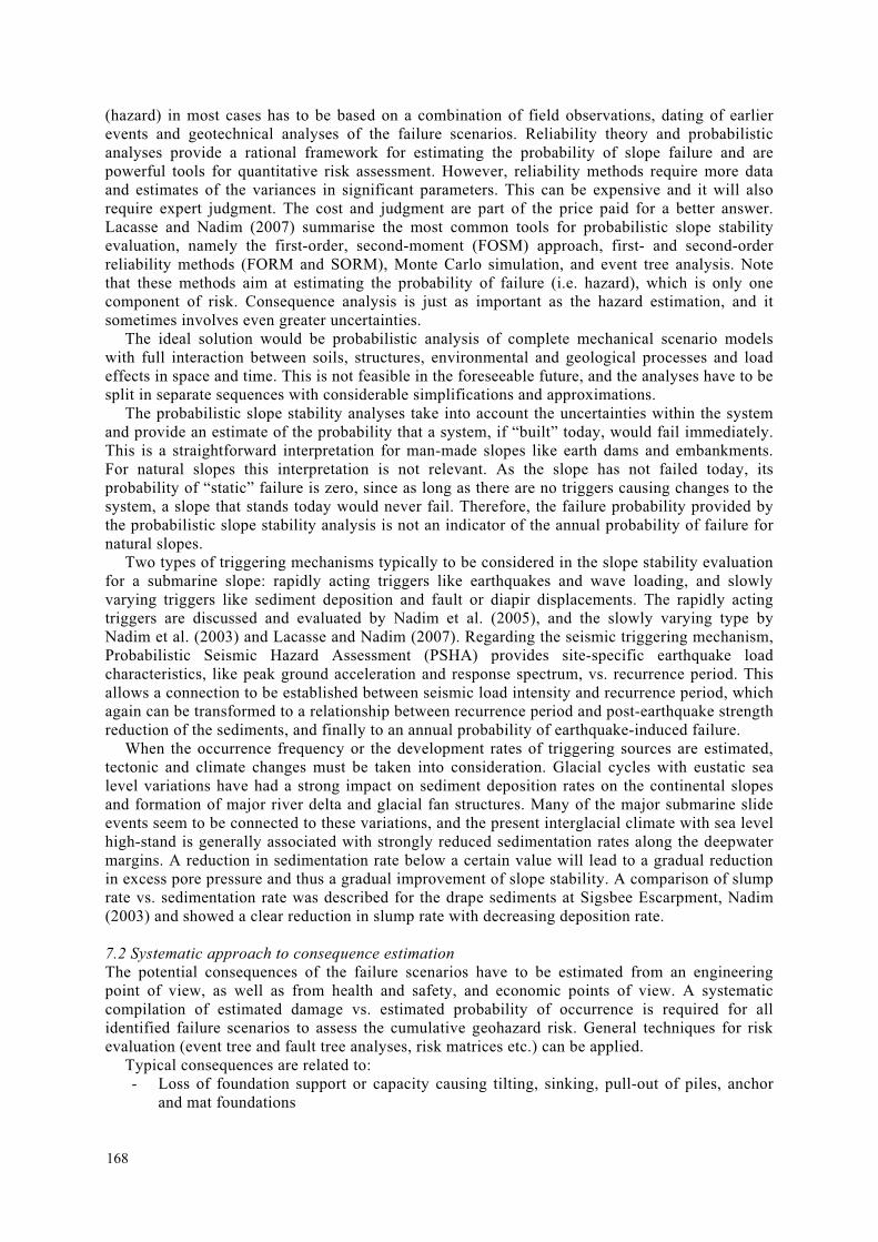
7.3 Risk assessment and acceptable risk The geohazard risk has to be included in the overall project risk evaluation. If the risk contribution is significant and not acceptable, risk reducing measures should be sought (Fig. 1). In areas with significant natural slide hazard potential, this is primarily relocation of wells, structures and pipelines to less hazardous areas, alternatively to protect structures against slide impact.
Risk assessment compares estimated level of risk with risk acceptance "criteria" and ranks scenarios or alternatives to establish priorities. Establishing "acceptable" and "tolerable" risk levels is difficult and can be the source of heated controversy. Existing target risk guidelines are generally based on engineering judgment and experience, and most of them suggest somewhat similar bounds of acceptable and unacceptable levels of annual probability of occurrence as functions of the consequence. International regulatory agencies have suggested risk criteria for land planning and managing industrial risks, e.g. the ALARP (As Low As Reasonably Practicable) principle (Health and Safety Executive, 1999; ANCOLD, 1996). The Whitman (1984) diagram (Fig. 4) provides an early example, with indication of tolerable risk for different facilities. Societal risks may also be expressed as curves of annual frequency of a threat (danger) causing fatalities, or any other consequences.
Fig.4 Examples of proposed risk acceptance criteria (Left: ANCOLD, 1996; Right: Whitman, 1984)
Risk mitigation is the process of selecting and implementing measures for managing the risks that have been identified. Low priority or acceptable risks may require no further consideration other than monitoring and periodic review. Other risks will require the identification and evaluation of treatment options and the implementation of mitigation measures, including monitoring and periodic review.
It should be noted that when computed risk levels for offshore geohazards are high, they could be a result of the large uncertainty associated with the strength and pore pressure data, and may indicate that more extensive investigations should be carried out.
Human-induced risks can be reduced through careful planning and engineering aimed at minimizing effects of human influence, or by increasing the redundancy of the field development system.
The assessment of geohazard risk must be based on available information about regional and local geology and site specific conditions regarding bathymetry, stratigraphy, soil conditions and field exploration and lay-out plans. In areas with potential geohazards there should be a high degree of interaction between field development planning and geohazard evaluations. During the project development the amount of information will increase, plans will typically be modified and
170
thus a staged approach is required. The number of stages required will depend on the findings from the previous stage and the complexity of the project.
8 CONCLUSIONS
The increasing activity on the deepwater part of the continental slopes has set focus on the need for a systematic treatment of geohazards risk. Risk assessment requires quantitative description of geology and sediment properties, identification of possible failure events, triggering sources and mechanisms and ability to judge the likelihood of occurrence and the damage potential involved.
An overview of site investigation methods, analysis tools and methodologies for geohazard risk assessment was described and put into a framework based on the authors' and NGI's experience from recent and ongoing projects.
With the changes in climate and the occurrence of more extreme natural phenomena than before (e.g. storms), one can not use only data from existing experience to estimate safety, but one should also events and triggers that are not covered by e.g. 100- or 1000-year return periods. Another keyword is the importance of multi-disciplinarity, and the need for increased awareness of complementarity, meaning wider expertise teams than before when evaluating hazard and risk, and the need to document cost-effectiveness of different measures.
The human element and engineering judgment in data processing, statistical analysis, geo-statistics and hazard and risk analysis are still important and necessary. The profession should not forfeit engineering judgment in favour of elegant mathematical solutions. Hazard and risk assessment present an opportunity to look at the bigger picture and seek out solutions that meet not just some arbitrary idea of acceptable/tolerable risk but an unknown risk. For the geotechnical engineer, the probabilistic (and risk) approach presents the opportunity to bring forth new ideas, see the problem as a whole, and avoid getting lost in the detail.
As contributor to the profession’s goals of documentation, continuity, high quality and innovation, and the ever-increasing requirement of globalization, hazard and risk assessment and the management of risk serve as communication vehicle among geo-specialists and other sectors of expertise.
ACKNOWLEDGMENTS
The authors would like to thank their many colleagues and peers whose contributions only received a passing mention in this paper, and NGI's clients for providing the opportunity to work on R&D projects and consultancy services concerning offshore geohazards. The support of the Research Council of Norway through the Centre of Excellence, International Centre for Geohazards (ICG), is also gratefully acknowledged.
REFERENCES
ANCOLD (1996). Commentary on ANCOLD "Guidelines on Risk Assessment". Sydney, Australia.
American Petroleum Institute (1993). API Recommended Practice for Design and Hazards Analysis for Offshore Production Facilities, API 14J, 1st Ed, American Petroleum Institute.
Bondevik, S., Løvholt, F., Harbitz, C.B., Mangerud, J., Dawson, A., Svendsen, J.I. (2005). The Storegga Slide tsunami – comparing filed observations with numerical simulations. Marine and Petroleum Geology, 22, Nos 1-2, pp.195-208. January/February.
Gauer, P., Issler, D., deBlasio, F.V. and Elverhøi, A. (2007). Dynamic modeling of submarine slide run-out/submarine mass movements; where do we stand and what are the main challenges? Proceedings, Offshore Technology Conference, Houston, TX, May 2007, Paper No. 18597.
171
GEBCO, IHO & BODC IOC (2003). General Bathymetric Chart of the Oceans. Centenary Edition of the GEBCO Digital Atlas, published on CD-ROM on behalf of the Intergovernmental Oceanographic Commission and the International Hydrographic Organization as part of the General Bathymetric Chart of the Oceans; British Oceanographic Data Centre, Liverpool.
Georgiadis, M. (1991). Landslide drag forces on pipelines, Soils and Foundations, Japanese Society of Soil mechanics and Foundation Engineering, Vol. 31, No. 1, pp.156-161, March.
Hampton, M., A., Lee, H.J., and Locat, J. (1996). Submarine landslides. Reviews of Geophysics, 34, pp.33-59.
Harbitz, C.B., Løvholt, L., and Glimsdal, S. (2007). Tsunamis generated by earthquakes and gravity mass flows – recent studies and future challenges for offshore geohazards. Proceedings, Offshore Technology Conference, Houston, TX, May 2007, Paper No. 18602.
Health and Safety Executive (1999). Reducing Risks, Protecting People, HSE, UK.
ISO (2000). International standard. Petroleum and natural gas industries - Offshore production installations - Guidelines on tools and techniques for hazard identification and risk assessment. ISO 17776:2000(E). First edition, 2000-10-15. International Organization for Standardization, Geneva, Switzerland.
Kvalstad, T.J. (2007). What is the Current "Best Practice" in Offshore Geohazard Investigations? A State-of-the-Art Review. Proceedings, Offshore Technology Conference, Houston, TX, May 2007, Paper No. 18545.
Kvalstad, T.J., K. Berg, P. Bryn, M. Wangen, F. Nadim, C.F. Forsberg, and P. Gauer (2005). The Storegga slide: Evaluation of triggering sources and slide mechanics. Marine and Petroleum Geology, 22, Nos 1-2, pp.299-310. January/February.
Lacasse, S., and Nadim, F. (2007). Probabilistic geotechnical analyses for offshore facilities. Georisk, Vol. 1, No. 1, pp.21-42, March.
Ladd, C.C., Foott, R. (1974). New design procedures for stability of soft clays. Journal of the Geotechnical Engineering Division, ASCE 100 (GT7), pp.763-786.
Locat, J., and Lee, H.J. (2002). Submarine landslides: Advances and challenges. Canadian Geotechnical Journal, 39, pp.193-212.
Locat, J., and Mienert J. (2003). Submarine Mass Movements and Their Consequences. 1st International Symposium. Kluwer Academic Publishers, 540 p.
Løvholt, F.,Harbitz, C.B., Haugen, K.B. (2005). Parametric studies of tsunamis generated by submarine slides in the Ormen Lange/Storegga area off western Norway. Marine and Petroleum Geology, 22, Nos 1-2, pp.219-232. January/February.
Nadim, F., Krunic, D., Jeanjean, P. (2003). Probabilistic slope stability analysis of the Sigsbee Escarpment, Proceedings OTC 15203, Offshore Technology Conference 2003, Houston, Texas, May 2003.
Nadim, F., Kvalstad, T.J., Guttormsen, T. (2005). Quantification of risk associated with instability at Ormen Lange. Marine and Petroleum Geology, 22, Nos 1-2, 311-318. January/February.
172
NORSOK (2001). NORSOK standard Z-013. Risk and emergency preparedness analysis, Revision 2, September.
Pazwash, H., Robertson, J.M. (1975). Forces on bodies in Bingham fluids, Journal of Hydraulic Research, Vol. 13, No. 1, pp.35-55.
Shapery, R.A., Dunlap, W.A. (1978). Prediction of storm-induced sea bottom movement and platform forces, Proceedings 10th Annual Offshore Technology Conference, Texas, OTC Paper No. 3259, May 8-11, pp.1789-1796.
Smith, W. H. F. and D. T. Sandwell (1994). Bathymetric prediction from dense satellite altimetry and sparse shipboard bathymetry, J. Geophys. Res., 99, pp.21803-21824.
Solheim, A., Forsberg, C.F., Vaidya, R.A., Rise, L. and Longva, O. (2007). The role of geological setting and depositional history in offshore slope instability. Proceedings, Offshore Technology Conference, Houston, TX, May 2007, Paper No. 18720.
Strout, J.M., and Tjelta, T.I. (2007). Excess pore pressure: measurement, monitoring, and its significance in offshore instability problems. Proceedings, Offshore Technology Conference, Houston, TX, May 2007, Paper No. 18706.
Sultan, N. (2007). Excess pore pressure and sediment deformation resulting from gas-hydrates dissociation and dissolution. Proceedings, Offshore Technology Conference, Houston, TX, May 2007, Paper No. 18532.
Syvitski, J.P.M., Burrell, D.C., and Skei, J.M., 1987. Fjords: Processes and Products. Springer-Verlag, New York, 379 p.
Tjelta, T.I., Svanø, G., Strout, J.M., Forsberg, C.F., Planke, S. and Johansen, H. (2007). Gas seepage and pressure build-up at a North Sea platform location; gas origin, transport mechanisms and potential hazards. Proceedings, Offshore Technology Conference, Houston, TX, May 2007, Paper No. 18699.
Westerdahl, H., Vanneste, M., Sparrevik, P., Madshus, C., Lecomte, I., Zuehlsdorff. L. (2007). Shear-wave source for offshore geohazard studies: A pilot project to improve seismic resolution and better constrain the shear strength of marine sediments. Proceedings, Offshore Technology Conference, Houston, TX, May 2007, Paper No. 18756.
Whitman, R.V. (1984). Evaluating Calculated Risk in Geotechnical Engineering. Journal of Geotechnical Engineering Division, ASCE, Vol. 110, No. 2, pp.145-188.
Zakeri, A. (2007). A literature review on debris flow impact on structures. ICG report 2007-6-1, International Centre for Geohazards, Oslo, Norway.
173

174