RIPARIAN HABITAT RESTORATION AT FOUR SITES …€¦ · Riparian Habitat Restoration at Four Sites...
156
RIPARIAN HABITAT RESTORATION AT FOUR SITES IN DOÑA ANA COUNTY, NEW MEXICO: JARALOSA, YESO EAST, YESO WEST, AND CROW CANYON C FINAL MONITORING REPORT CONTRACT # IBM15D0005/TASK ORDER # IBM16T0019 JULY 2018 PREPARED FOR U.S. International Boundary and Water Commission PREPARED BY Gulf South Research Corporation and SWCA Environmental Consultants
Transcript of RIPARIAN HABITAT RESTORATION AT FOUR SITES …€¦ · Riparian Habitat Restoration at Four Sites...

RIPARIAN HABITAT RESTORATION AT FOUR SITES IN DOÑA ANA COUNTY, NEW MEXICO: JARALOSA, YESO EAST, YESO WEST, AND CROW CANYON C
FINAL MONITORING REPORT CONTRACT # IBM15D0005/TASK ORDER # IBM16T0019
JULY 2018
PREPARED FOR
U.S. International Boundary and Water Commission
PREPARED BY
Gulf South Research Corporation
and
SWCA Environmental Consultants


RIPARIAN HABITAT RESTORATION AT FOUR SITES IN DOÑA ANA COUNTY, NEW MEXICO: JARALOSA, YESO EAST, YESO WEST, AND CROW CANYON C
FINAL MONITORING REPORT Contract # IBM15D0005/Task Order # IBM16T0019
Prepared for:
U.S. International Boundary and Water Commission U.S. Section
4171 North Mesa, Suite C-100 El Paso, Texas 79902
Prepared by:
Gulf South Research Corporation 8081 Innovation Park Drive
Baton Rouge, Louisiana 70820
and
SWCA Environmental Consultants 5647 Jefferson Street NE
Albuquerque, New Mexico 87109
July 2018


Riparian Habitat Restoration at Four Sites in Doña Ana County, New Mexico: Jaralosa, Yeso East, Yeso West, and Crow Canyon C – Final Monitoring Report
i
ABSTRACT/EXECUTIVE SUMMARY
The U.S. International Boundary Water Commission (USIBWC) committed to restoring riparian habitat and implementing invasive species management within the Rio Grande Canalization Project. Gulf South Research Corporation (GSRC) and SWCA Environmental Consultants (SWCA) were contracted to implement restoration activities at four sites (Jaralosa, Yeso East, Yeso West, and Crow Canyon C) totaling 19.2 acres located north of Hatch, in Doña Ana County, New Mexico.
The target habitats for the selected sites include open riparian woodland and dense riparian shrub. The purpose of the restoration project is to improve the riparian zone through increasing suitable feeding, breeding, and sheltering habitat for the southwestern willow flycatcher (Empidonax traillii extimus; flycatcher) and the yellow-billed cuckoo (Coccyzus americanus). To increase habitat for these key species, plans call for removing non-native vegetation and planting native trees and shrubs. Habitat restoration consists of creating willow (Salix sp.)–dominated stands, Rio Grande cottonwood (Populus deltoids spp. wislizeni) gallery forests, and buffer areas planted with native riparian shrubs and native herbaceous vegetation typical of the surrounding floodplain.
Restoration activities implemented for this project include invasive species management, floodplain and swale excavation, and planting coyote willow (Salix exigua), Goodding’s willow (Salix gooddingii), and cottonwood poles and native shrubs at each site. GSRC was the prime contractor and as such was responsible for program management and ensuring that contract requirements were fulfilled. SWCA oversaw the implementation of restoration activities, monitoring, and reporting. Under subcontract to SWCA, Restoration Solutions and High Desert Native Plants (HDNP) assisted with project execution. Restoration Solutions provided site preparation, invasive species control, and planting assistance. HDNP provided and installed all plant material and performed follow-up watering and maintenance activities.
Saltcedar (Tamarix spp.) was the dominant non-native woody species present on the four sites. The entire tree/shrub was extracted along with its root crown and masticated at designated areas. Follow-up resprout control consisted of a low-volume basal bark application of Garlon 4. Shallow swales were excavated at Jaralosa and Yeso East in abandoned meander channels to reduce the depth to groundwater and create more favorable planting conditions. An experimental inset floodplain was excavated at Yeso West to create inundated conditions to create wetlands and improve habitat for the flycatcher.
Across all sites, 5,010 coyote willow poles, 634 Goodding’s willow poles, 689 cottonwood poles, and 623 tall pot shrubs were planted. A native grass/forb seed mix was seeded in disturbance areas. Final survival rates across all sites, accounting for replacement plantings were 76.5% for coyote willow, 83.4% for Goodding’s willow, 79% for cottonwood, and 96.5% for native shrubs.
Challenges included disturbances that affect planting survival, including off-road vehicle disturbance, livestock damage, invertebrate herbivory, beaver herbivory, herbicide drift from nearby agricultural operations, and heat stress. Variable depths to groundwater, sometimes exceeding 10 feet, at the time of planting also created challenges in finding suitable planting conditions. Rapid groundwater drawdown following the end of the irrigation season in fall 2017 further stressed planted poles. The Yeso West site was inundated throughout the irrigation season and was subject to scour during a monsoonal rain event.
Despite the challenges, the plantings showed resiliency and rebounded in spring 2018. Many of the pole plantings exhibited top-growth dieback with resprouting at the base. This condition was especially prevalent with both willow species, but was also documented for cottonwood. Resprouting occurred throughout the first-year growing season, but was most evident in the spring 2018 monitoring sessions. At the Yeso West site native wetland vegetation and willow resprouting was evident during the spring 2018 monitoring sessions.

Riparian Habitat Restoration at Four Sites in Doña Ana County, New Mexico: Jaralosa, Yeso East, Yeso West, and Crow Canyon C – Final Monitoring Report
ii
Management recommendations include 1) installing nested piezometers to supplement existing groundwater data and document groundwater flow; 2) creating swales to reduce depth to groundwater; 3) continue to acquire water rights to provide supplemental water in strategic locations; 4) improving signage and outreach to neighbors, and 5) conducting additional hydraulic modeling using updated surveys to establish cut elevations and identify target inundation discharge prior to initiating inset floodplain features.

Riparian Habitat Restoration at Four Sites in Doña Ana County, New Mexico: Jaralosa, Yeso East, Yeso West, and Crow Canyon C – Final Monitoring Report
iii
CONTENTS
Abstract/Executive Summary ..................................................................................................................... i
1 Introduction ....................................................................................................................................... 1-1
2 Restoration Activities ........................................................................................................................ 2-1 2.1 Site Preparation .......................................................................................................................... 2-1
2.1.1 Non-Native Plant Removal .............................................................................................. 2-1 2.1.2 Excavation ....................................................................................................................... 2-1
2.2 Native Plantings ......................................................................................................................... 2-2 2.2.1 Planting Summary ............................................................................................................ 2-4 2.2.2 Native Shrub Plantings .................................................................................................... 2-7 2.2.3 Native Grass and Forb Seeding ........................................................................................ 2-8
3 Results................................................................................................................................................. 3-1 3.1 General Site Conditions ............................................................................................................. 3-1 3.2 Native Planting Survival ............................................................................................................ 3-7 3.3 Non-Native Species ................................................................................................................. 3-12 3.4 Native Grass and Forb Seeding ............................................................................................... 3-14 3.5 Groundwater Monitoring ......................................................................................................... 3-14 3.6 Repeat Photography ................................................................................................................. 3-17
4 Conclusions and Discussion .............................................................................................................. 4-1 4.1 General Observations ................................................................................................................ 4-1 4.2 Site Analysis .............................................................................................................................. 4-2
4.2.1 Jaralosa............................................................................................................................. 4-2 4.2.2 Yeso East ......................................................................................................................... 4-2 4.2.3 Crow Canyon C ............................................................................................................... 4-3 4.2.4 Yeso West ........................................................................................................................ 4-3
4.3 Management Recommendations ................................................................................................ 4-4
5 Literature Cited ................................................................................................................................. 5-1
Appendices
Appendix A. Field Data Forms
Appendix B. Repeat Photo Points
Appendix C. Planting Area Maps
Appendix D. Restoration Plan

Riparian Habitat Restoration at Four Sites in Doña Ana County, New Mexico: Jaralosa, Yeso East, Yeso West, and Crow Canyon C – Final Monitoring Report
iv
Tables
Table 1. Summary of Restoration Sites ..................................................................................................... 1-1 Table 2. Planting Quantities at Each Restoration Site ............................................................................... 2-5 Table 3. Replanting Summary ................................................................................................................... 2-6 Table 4. Seed Mix Specifications .............................................................................................................. 2-8 Table 5. Dominant Vegetation Observed at the Four Restoration Sites, May 2018 .................................. 3-1 Table 6. Total Number of Dead Stems Counted at Each Site per Monitoring Event ................................ 3-8 Table 7. Species Survival at Each Site Based on Actual Poles Planted* ................................................... 3-9 Table 8. Mortality at Each Site Based on Planting Specifications† ......................................................... 3-10 Table 9. Planting Survival and Contract Mortality Compliance Summary ............................................. 3-12 Table 10. Groundwater Monitoring Well Data ........................................................................................ 3-16
Figures
Figure 1. Overview of the four restoration sites. ....................................................................................... 1-2 Figure 2. Saltcedar extraction (left) and chipped masticated material (right). ........................................... 2-1 Figure 3. Swale excavation at Jaralosa, near well JARMW-1; view facing south. ................................... 2-2 Figure 4. Yeso West inset floodplain; view facing west from across the river. ......................................... 2-2 Figure 5. Goodding’s willow pole planting using auger mounted to an excavator. .................................. 2-3 Figure 6. Coyote willow planted in a trench excavated to moist soil conditions indicating the depth
to groundwater. ....................................................................................................................... 2-3 Figure 7. Poles stored in a refrigerated trailer. ........................................................................................... 2-4 Figure 8. Tall pot shrubs. ........................................................................................................................... 2-7 Figure 9. Tall pot shrub showing root mass. .............................................................................................. 2-7 Figure 10. A newly planted baccharis willow shrub. ................................................................................. 2-8 Figure 11. Seed imprinter, high desert native plants. ................................................................................. 2-9 Figure 12. Evidence of beaver herbivory at Yeso East. ............................................................................. 3-2 Figure 13. Evidence of damage caused by mule deer on a Goodding’s willow plant at Jaralosa. ............. 3-2 Figure 14. View of herbicide spraying incident at Yeso East, facing southeast, March 2017. Note
herbicide drift across the levee onto the site. .......................................................................... 3-3 Figure 15. View of off-road vehicle disturbance on the bank of Jaralosa, facing west, November
2017. ....................................................................................................................................... 3-4 Figure 16. View of fence at the southern end of Yeso West showing new strand of barbed wire
installed after the high-flow event, November 2017. .............................................................. 3-4 Figure 17. Yeso West inundation; June 2017 discharge = 48.35 cms (1,707 cfs). Note livestock
presence. ................................................................................................................................. 3-5 Figure 18. View of Yeso West showing high-water event damage and salt crusts, facing northeast,
November 2017. ...................................................................................................................... 3-6 Figure 19. View of Yeso West showing woody debris accumulated at thesouthern end of the site,
facing southeast, November 2017. .......................................................................................... 3-6 Figure 20. The outer stems of a willow (Salix sp.) pole planting snap easily when dead. Some of
these plantings that have dead upper growth may still survive with growth of tissues at the base of the pole planting. .................................................................................................. 3-7
Figure 21. Some plantings displayed partial or complete dieback of aboveground growth with vigorous resprouting at the base, such as this Rio Grande Cottonwood, April 2018. ............. 3-8

Riparian Habitat Restoration at Four Sites in Doña Ana County, New Mexico: Jaralosa, Yeso East, Yeso West, and Crow Canyon C – Final Monitoring Report
v
Figure 22. Saltcedar resprouts at Crow Canyon C, June 2017. ................................................................ 3-13 Figure 23. View of treated saltcedar resprouts at Crow Canyon C, April 2018. ..................................... 3-13 Figure 24. View of treated saltcedar resprouts at Jaralosa, facing southwest, April 2018....................... 3-14 Figure 25. Typical wellhead with locking cap removed and ready for a depth-to-groundwater
measurement. ........................................................................................................................ 3-15 Figure 26. Cottonwood trees showing excellent vigor at Yeso East; repeat photo Y1, looking
northwest, May 2018. Trees were planted in a swale excavated in an abandoned meander. .................................................................................................................................. 4-3

Riparian Habitat Restoration at Four Sites in Doña Ana County, New Mexico: Jaralosa, Yeso East, Yeso West, and Crow Canyon C – Final Monitoring Report
vi
This page intentionally left blank.

Riparian Habitat Restoration at Four Sites in Doña Ana County, New Mexico: Jaralosa, Yeso East, Yeso West, and Crow Canyon C – Final Monitoring Report
1-1
1 INTRODUCTION 1
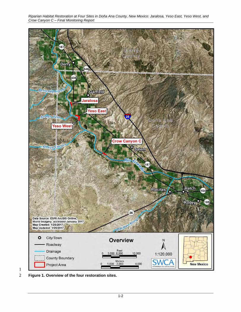
The U.S. International Boundary Water Commission’s (USIBWC’s) 2009 Record of Decision for River 2 Management Alternatives for the Rio Grande Canalization Project commits the agency to implement 3 invasive species management and riparian habitat restoration within the Rio Grande Canalization Project. 4 Gulf South Research Corporation (GSRC) and SWCA Environmental Consultants (SWCA) were under 5 contract to implement restoration activities at four sites (Jaralosa, Yeso East, Yeso West, and Crow 6 Canyon C) totaling 19.2 acres located north of Hatch, in Doña Ana County, New Mexico (Figure 1). 7
The target habitats identified in the Conceptual Restoration Plan (U.S. Army Corps of Engineers 8 [USACE] 2009) and the Site Implementation Plan (TRC Environmental Corporation [TRC] 2011) for the 9 selected sites are open riparian woodland and dense riparian shrub (Table 1). The restoration activities 10 outlined and implemented will help improve the riparian zone, increasing suitable feeding, breeding, and 11 sheltering habitat for the southwestern willow flycatcher (Empidonax traillii extimus; flycatcher) and the 12 yellow-billed cuckoo (Coccyzus americanus). To increase habitat for these key species, plans call for 13 removing non-native vegetation and planting native trees and shrubs. Habitat restoration consists of 14 creating willow (Salix sp.)–dominated stands, cottonwood (Populus deltoids spp. wislizeni) gallery 15 forests, and buffer areas planted with native riparian shrubs typical of the surrounding floodplain. 16
Table 1. Summary of Restoration Sites 17
Site Acres Target Habitat Restoration Work Type
Jaralosa 4.5 Open riparian woodland Old river meander
Yeso East 9.7 Open riparian woodland Old river meander
Yeso West 1.6 Dense riparian shrub (flycatcher) Creation of inset floodplain
Crow Canyon C 3.4 Dense riparian shrub (flycatcher) Existing inset floodplain in need of enhancement
Restoration activities implemented for this project include invasive species management, floodplain and 18 swale excavation, and planting coyote willow (Salix exigua), Goodding’s willow (Salix gooddingii), and 19 Rio Grande cottonwood poles and native shrubs at each site. Restoration techniques are described in the 20 Restoration Plan (SWCA 2017). 21
This report describes monitoring activities at four riparian habitat restoration sites. SWCA/GSRC 22 biologists completed six post restoration monitoring sessions, four sessions in 2017 (March, June, 23 September, and November) and two sessions in 2018 (April and May). Monitoring of the Yeso West site 24 was limited to surveillance from the east bank of the river during the June and September monitoring 25 sessions due to high river depth and deeply washed-out access roads. The biologists were again able to 26 access Yeso West and conducted monitoring in November 2017 and the two monitoring sessions in 27 spring 2018. 28
The monitoring of restoration success consisted of completing qualitative field assessments to document 29 the general health and viability of native plantings and the existence of both native and non-native species 30 within the project area. The biologists also measured depth to groundwater at the seven USIBWC 31 monitoring wells in order to document any trends or fluctuations in depth-to-groundwater conditions 32 experienced by the new plantings at the sites. 33
The field data sheets are presented in Appendix A. Photographs were recorded at permanent photo points 34 established by SWCA in order to provide a chronological display of site conditions and restoration 35 success (Appendix B). 36
Riparian Habitat Restoration at Four Sites in Doña Ana County, New Mexico: Jaralosa, Yeso East, Yeso West, and Crow Canyon C – Final Monitoring Report
1-2
1
Figure 1. Overview of the four restoration sites. 2

Riparian Habitat Restoration at Four Sites in Doña Ana County, New Mexico: Jaralosa, Yeso East, Yeso West, and Crow Canyon C – Final Monitoring Report
2-1
2 RESTORATION ACTIVITIES 1
2.1 Site Preparation 2
Site preparation included non-native plant removal and excavating swales and creating an inset 3 floodplain. Subcontractor to SWCA, Restoration Solutions completed all site preparation activities from 4 late February through mid-March 2017. 5
2.1.1 Non-Native Plant Removal 6
Saltcedar (Tamarix spp.) was the dominant non-native woody species present on the four sites. 7 An excavator fitted with a clasping thumb attachment removed the entire shrub/tree along with its root 8 crown and placed the extracted biomass in windrows where it was masticated on-site (Figure 2). 9
10
Figure 2. Saltcedar extraction (left) and chipped masticated material (right). 11
Follow-up herbicide treatments of saltcedar resprouts were completed on April 18, 2018, using a low-12 volume basal bark application of Garlon 4. 13
2.1.2 Excavation 14
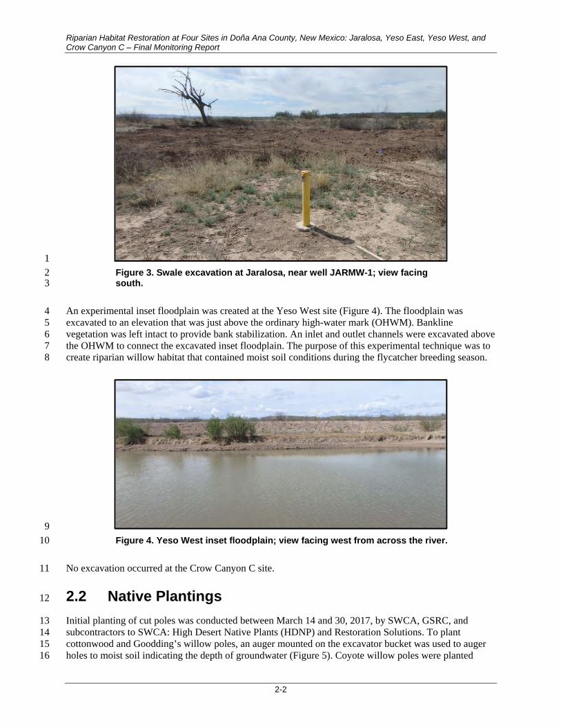
At the Jaralosa and Yeso East sites, SWCA’s subcontractor excavated 1 to 2 feet of soil to create swales 15 (Figure 3) in abandoned meanders (Appendix C, Figures C-1 and C-2). The purpose of the swale 16 excavation was to decrease the depth to groundwater and increase the area suitable for planting native 17 vegetation. Cottonwood and Goodding’s willow plantings were concentrated in these areas. 18
Riparian Habitat Restoration at Four Sites in Doña Ana County, New Mexico: Jaralosa, Yeso East, Yeso West, and Crow Canyon C – Final Monitoring Report
2-2
1
Figure 3. Swale excavation at Jaralosa, near well JARMW-1; view facing 2 south. 3
An experimental inset floodplain was created at the Yeso West site (Figure 4). The floodplain was 4 excavated to an elevation that was just above the ordinary high-water mark (OHWM). Bankline 5 vegetation was left intact to provide bank stabilization. An inlet and outlet channels were excavated above 6 the OHWM to connect the excavated inset floodplain. The purpose of this experimental technique was to 7 create riparian willow habitat that contained moist soil conditions during the flycatcher breeding season. 8
9
Figure 4. Yeso West inset floodplain; view facing west from across the river. 10
No excavation occurred at the Crow Canyon C site. 11
2.2 Native Plantings 12
Initial planting of cut poles was conducted between March 14 and 30, 2017, by SWCA, GSRC, and 13 subcontractors to SWCA: High Desert Native Plants (HDNP) and Restoration Solutions. To plant 14 cottonwood and Goodding’s willow poles, an auger mounted on the excavator bucket was used to auger 15 holes to moist soil indicating the depth of groundwater (Figure 5). Coyote willow poles were planted 16

Riparian Habitat Restoration at Four Sites in Doña Ana County, New Mexico: Jaralosa, Yeso East, Yeso West, and Crow Canyon C – Final Monitoring Report
2-3
either using the auger method or trenching (Figure 6). The goal for either method was to locate moist soil 1 conditions, indicative of the groundwater level. Due to variability in depth to groundwater, it was often 2 necessary to drill several holes to find suitable soil conditions. 3
4
Figure 5. Goodding’s willow pole planting using auger mounted 5 to an excavator. 6
7
Figure 6. Coyote willow planted 8 in a trench excavated to moist soil 9 conditions indicating the depth to 10 groundwater. 11

Riparian Habitat Restoration at Four Sites in Doña Ana County, New Mexico: Jaralosa, Yeso East, Yeso West, and Crow Canyon C – Final Monitoring Report
2-4
HDNP grew out Goodding’s willow and cottonwood poles in their facilities near El Paso, Texas. All 1 poles are of local genotypes. Due to warm conditions in January and February 2017, HDNP stored poles 2 in a refrigerated trailer covered with moist mulch (Figure 7). Field crews harvested coyote willow poles 3 on-site and stored in the trailer. Prior to planting, field crew took the poles out of storage and soaked them 4 in a water tank. 5
6
Figure 7. Poles stored in a refrigerated trailer. 7
2.2.1 Planting Summary 8
The planting activity generally followed the planting plan presented in the Restoration Plan (SWCA 9 2017), which is provided in, Appendix D. The project team proposed and implemented changes from the 10 specifications listed in the Statement of Work (SOW). The USIBWC approved the following project 11 changes: 12
Changes in the number of specified poles at a given site. The project team requested transferring 13 a number of Goodding’s willow and coyote willow poles from the Crow Canyon C site to the 14 Yeso West and Yeso East sites. The project team requested the changes in an effort to plant poles 15 in suitable locations based on depth to groundwater at the time of planting and existing soil 16 conditions. 17
Change in native shrub planting schedule and shrub size. Based on the recommendations from 18 HDNP, the project team requested a change in schedule for planting the long-stem shrubs to fall. 19 The requested change allowed HDNP to grow out shrubs in a tall pot form, which would result in 20 a greater root mass. Fall planting was also believed to be a more suitable time to plant the shrubs. 21
Over planting. The project team planted additional poles at each site to compensate for potential 22 mortalities. 23

Riparian Habitat Restoration at Four Sites in Doña Ana County, New Mexico: Jaralosa, Yeso East, Yeso West, and Crow Canyon C – Final Monitoring Report
2-5
Table 2 summarizes planting quantities of coyote willow (Salix exigua), Goodding’s willow (Salix 1 gooddingii), and Rio Grande cottonwood (Populus deltoides ssp. wislizenii) poles at each of the sites, 2 including replanted quantities. Please see Appendix C for planting area maps. 3
Table 2. Planting Quantities at Each Restoration Site 4
Site
Coyote Willow Poles Goodding’s Willow Poles Cottonwood Poles Long-Stem Riparian Shrubs
SOW Specification
Actual Planted
SOW Specification
Actual Planted
SOW Specification
Actual Planted
SOW Specification
Actual Planted
Jaralosa 1,000* 1,260 100 110 60 72 50 60
Yeso East 800 820 50 59 485 490 485 518
Yeso West 1,000 1,790 50 50 20 20 0† 0
Crow Canyon C 2,100 1,140 400 415 100 107 35 45
Total 4,900 5,010 600 634 665 689 570 623
* Coyote willow planting at Jaralosa approved by USIBWC. 5 † The approved planting plan specified that there would be no long-stem riparian shrubs planted at the Yeso West site. 6
2.2.1.1 JARALOSA 7
The project team completed planting at Jaralosa on March 22, 24, and 28, 2017 (see Figure C-1). In total, 8 1,260 coyote willows were planted along the bank line, filling in gaps exposed by saltcedar (Tamarix sp.) 9 removal and where native vegetation was absent. The excavated swale was planted with 110 Goodding’s 10 willow poles and 72 cottonwood poles. Planting was conducted with a 5-foot by 6-inch auger with a 11 5-foot extension and a 10-foot by 4-inch continuous flight auger. 12
2.2.1.2 YESO EAST 13
Planting at Yeso East was conducted between March 17 and March 23, 2017 (see Figure C-2). In total, 14 820 coyote willow poles were planted along the bank line. The upland swale was planted with 15 490 cottonwood and 59 Goodding’s willow poles. Seeding and long-stem shrubs were planted in the fall 16 in September 2017 when conditions were more favorable. Planting was conducted with a 5-foot by 6-inch 17 auger with a 5-foot extension and a 10-foot by 4-inch continuous flight auger. 18
2.2.1.3 YESO WEST 19
Planting at Yeso West was conducted between March 15 and 29, 2017 (see Figure C-2). In total, 20 1,790 coyote willow poles were planted along the bank and within the excavated area. In addition to the 21 coyote willows, 59 Goodding’s willow and 20 cottonwood poles were planted within the excavated area. 22 Planting was conducted with a 5-foot by 6-inch auger with a 5-foot extension. 23
2.2.1.4 CROW CANYON C 24
Crow Canyon C was planted between the dates of March 14 and 29, 2017 (see Figure C-3). In total, 25 1,140 coyote willow poles were planted along the bank and upland intermixed with 415 Goodding’s 26 willow and 107 cottonwood poles. Planting was conducted with a 5-foot by 6-inch auger with a 5-foot 27 extension and a 10-foot by 4-inch continuous flight auger. 28

Riparian Habitat Restoration at Four Sites in Doña Ana County, New Mexico: Jaralosa, Yeso East, Yeso West, and Crow Canyon C – Final Monitoring Report
2-6
2.2.1.5 REPLANTING 1
The GSRC/SWCA team was required to replant cottonwood and Goodding’s willow poles to replace 2 mortality. The USIBWC established a 15% mortality (85% survival) threshold for acceptable survival of 3 planted poles and shrubs. The November 2017 monitoring session provided the baseline for the number 4 of replacement plants. Due to conditions beyond the project team’s control at Yeso West, the USIBWC 5 approved eliminating replacement coyote willow plantings at Yeso West. GSRC/SWCA agreed to replant 6 173 Goodding’s willow and 184 cottonwood poles across all sites, allowing the contractor flexibility to 7 determine the most appropriate sites/locations to replant. GSRC/SWCA elected to plant all Goodding’s 8 willow and cottonwood poles at Jaralosa, Yeso East, and Crow Canyon C. We did not replant any 9 Goodding’s willow and cottonwood poles at Yeso West. In November 2017, the survival rate at all sites, 10 excluding Yeso West, exceeded 98% (3,835 survived out 3900 specified in the SOW). Therefore, we 11 were not required to replace coyote willow poles. HDNP completed replanting on March 16, 2018. 12 Table 3 summarizes the quantities of each species replanted by site. 13
Table 3. Replanting Summary 14
Species Site Jaralosa Yeso East
Yeso West
Crow Canyon C
Total Notes
Coyote Willow Poles
Revised SOW 1,260 800 1,700 1,140 4,900
# Survived (Revised SOW)
1,100 788 847 1,100 3,835
% Mortality 12.7% 1.5% 50.2% 3.5% 21.7%
Total Replanted 0 0 0 0 0
Goodding’s Willow Poles
SOW 100 50 50 400 600
# Survived (Revised SOW)
69 14 4 340 427
% Mortality 31.0% 72.0% 92.0% 15.0% 28.8%
Total Replanted 54 59 0 60 173 46 dead poles at Yeso West, 50% planted at Jaralosa, 50% planted at Yeso East
Cottonwood Poles
SOW 60 485 20 100 665
# Survived (Revised SOW)
40 370 2 69 481
% Mortality 33.3% 23.7% 90.0% 31.0% 27.7%
Total Replanted 38 115 0 31 184 18 dead poles at Yeso West, all planted at Jaralosa
Native Shrubs SOW 50 485 0 35 570
# Survived (Revised SOW)
60 518 0 45 623
% Mortality 0.0% 0.0% 0 0.0% 0.0%
Total Replanted 0 0 0 0 0
Total Native Planting
SOW 1,470 1,820 1,770 1,675 6,735
# Survived (Revised SOW)
1,269 1,690 853 1,554 5,366
% Mortality 13.7% 7.1% 51.8% 7.2% 20.3%
Total Replanted 92 174 0 91 357

Riparian Habitat Restoration at Four Sites in Doña Ana County, New Mexico: Jaralosa, Yeso East, Yeso West, and Crow Canyon C – Final Monitoring Report
2-7
2.2.2 Native Shrub Plantings 1
HDNP completed planting native shrubs in late September and early October 2017 using the tall pot 2 planting method (Figure 8 through Figure 10). Four species were planted: baccharis willow (Baccharis 3 salicina), fourwing saltbush (Atriplex canescens), skunkbush sumac (Rhus trilobata), and desert willow 4 (Chilopsis linearis). Table 2 provides the total number of shrubs planted at each site. 5
6
Figure 8. Tall pot shrubs. 7
8
Figure 9. Tall pot shrub showing root mass. 9

Riparian Habitat Restoration at Four Sites in Doña Ana County, New Mexico: Jaralosa, Yeso East, Yeso West, and Crow Canyon C – Final Monitoring Report
2-8
1
Figure 10. A newly planted baccharis willow shrub. 2
2.2.3 Native Grass and Forb Seeding 3
Seeding of native grasses and forbs was completed in September 2017 following a period of monsoonal 4 rain events that created moist soil conditions. Table 4 identifies the species and quantities planted. 5 Planting areas are indicated in the Planting Area Maps found in Appendix C. Seeding was completed 6 using an imprinter. The imprinter (Figure 11) is a drop seeder with a large, wedged roller drum that 7 deposits seed in patterned depressions, or dimples created in the soil surface. The dimples create 8 microhabitat conditions where moisture, organic matter, and wind-blown silt and clay are collected and 9 conserved, aiding in seed germination. Soil imprinting is a technique developed for revegetating barren, 10 arid soils (Permaculture Research Institute 2018) 11
Table 4. Seed Mix Specifications 12
Common Name Scientific Name Area (acres) Total Seed (PLS)* Total PLS/ acre
Desert marigold Baileya multiradiata 15 4 0.27
Common sunflower Helianthus annuus 15 15 1.00
Woolly paperflower Psilostrophe tagetina 15 8 0.53
Redwhisker clammyweed Polanisia dodecandra 15 8 0.53
Wooly prairie clover Dalea lanata 15 8 0.53
Penstemon Penstemon sp. 15 8 0.53
Indian ricegrass Achnatherum hymenoides 15 30 2.00
Saltgrass Distichlis spicata 15 15 1.00
Scratchgrass Muhlenbergia asperifolia 15 3 0.20
Tobosagrass Pleuraphis mutica 15 8 0.53
Alkali sacaton Sporobolus airoides 15 15 1.00
Salt bush Atriplex canescens 15 8 0.53

Riparian Habitat Restoration at Four Sites in Doña Ana County, New Mexico: Jaralosa, Yeso East, Yeso West, and Crow Canyon C – Final Monitoring Report
2-9
Common Name Scientific Name Area (acres) Total Seed (PLS)* Total PLS/ acre
Sand dropseed Sporobolous cryptandrus 15 15 1.00
TOTAL pls
145 9.67
*PLS – Pure Live Seed, in pounds 1
2
Figure 11. Seed imprinter, high desert native plants. 3

Riparian Habitat Restoration at Four Sites in Doña Ana County, New Mexico: Jaralosa, Yeso East, Yeso West, and Crow Canyon C – Final Monitoring Report
2-10
This page intentionally left blank. 1

Riparian Habitat Restoration at Four Sites in Doña Ana County, New Mexico: Jaralosa, Yeso East, Yeso West, and Crow Canyon C – Final Monitoring Report
3-1
3 RESULTS 1
3.1 General Site Conditions 2
Native shrubs and grasses generally dominate vegetation regrowth in the project area. Honey mesquite 3 Prosopis glandulosa) is a dominant species at Jaralosa with an estimated cover of 50%. It is found less 4 commonly at the Yeso East and Crow Canyon C sites and is absent from the Yeso West site. Arrowweed 5 (Pluchea sericea) is common at the Yeso East and Crow Canyon C sites, with an estimated cover of 6 40% and 45%, respectively. At Yeso West, there was a significant recruitment of willow baccharis 7 (Baccharis salicina) and several wetland species such as narrowleaf cattail (Typha latifolia), Baltic rush 8 (Juncus balticus), and hardstem bulrush (Schoenoplectus acutus). 9
The most common non-native species documented within the project area were saltcedar (Tamarix 10 chinensis), Bermudagrass (Cynodon dactylon), and Russian thistle (Salsola tragus) (see field data sheets 11 in Appendix A). These species were particularly prevalent in the recently disturbed areas of the sites. 12 Table 5 provides a summary of the dominant species observed. We used the May 2018 data for the cover 13 estimates. 14
Table 5. Dominant Vegetation Observed at the Four Restoration Sites, May 2018 15
Common Name Scientific Name Site Estimated Cover (%))
Jaralosa Yeso East Yeso West Crow Canyon C
Native Species
Honey mesquite Prosopis glandulosa 50 20
15
Fourwing saltbush Atriplex canescens 10
Pale-desert thorn (pale wolfberry)
Lycium pallidum 10 10
Sand dropseed Sporobolus cryptandrus 5
Willow baccharis Baccharis salicina
5 40
Arrowweed Pluchea sericea
40
45
Narrowleaf cattail Typha latifolia
40
Hardstem bulrush Schoenoplectus acutus
10
Saltgrass Distichlis spicata
10
Single whorl burrobush Hymenoclea monogyra
30
Rio Grande cottonwood Populus deltoides ssp. wislizeni
10
Non-Native Species
Saltcedar Tamarix chinensis 0 0 0 1
Barnyardgrass Echinochloa crus-galli
1
Prickly Russian thistle Salsola tragus 5 1
Bermuda grass Cynodon dactylon 5
SWCA/GSRC biologists observed evidence of wildlife herbivory on planted poles, including American 16 beaver (Figure 12) and mule deer (Figure 13). Other wildlife observed included kestrel, northern harrier, 17 osprey, red-wing black bird, house finch, red-tail hawk, chipping sparrow, white-crowned sparrow, 18 Gambel’s quail, and cottontail rabbit. 19

Riparian Habitat Restoration at Four Sites in Doña Ana County, New Mexico: Jaralosa, Yeso East, Yeso West, and Crow Canyon C – Final Monitoring Report
3-2
1
Figure 12. Evidence of beaver herbivory at Yeso East. 2
3
Figure 13. Evidence of damage caused by mule deer on a Goodding’s 4 willow plant at Jaralosa. 5

Riparian Habitat Restoration at Four Sites in Doña Ana County, New Mexico: Jaralosa, Yeso East, Yeso West, and Crow Canyon C – Final Monitoring Report
3-3
SWCA/GSRC biologists observed evidence of activities that created disturbance or otherwise affected 1 the restoration sites. These include herbicide drift, off-road vehicle use, and livestock grazing. In March 2 2017, SWCA and GSRC observed herbicide applied onto the levee road slopes adjacent to new pole 3 plantings at Yeso East (Figure 14). A video taken by SWCA biologist Ian Dolly shows herbicide mist 4 drifting over the levee road onto the habitat restoration site. Upon inquiry, GSRC biologist John Ginter 5 stopped the operator, asked what herbicide was being applied, and was informed that it was Roundup. 6 It is likely that additional unobserved herbicide applications may have occurred along the levee slopes 7 adjacent to the new plantings. Biologists observed evidence of off-road vehicle disturbance at Jaralosa 8 (Figure 15). Evidence of livestock damage was limited to the Yeso West site where livestock were able 9 to access the site despite repair of the fence following excavation and planting (Figure 16 and Figure 17). 10
11
Figure 14. View of herbicide spraying incident at Yeso East, facing 12 southeast, March 2017. Note herbicide drift across the levee onto the site. 13

Riparian Habitat Restoration at Four Sites in Doña Ana County, New Mexico: Jaralosa, Yeso East, Yeso West, and Crow Canyon C – Final Monitoring Report
3-4
1
Figure 15. View of off-road vehicle disturbance on the bank of Jaralosa, 2 facing west, November 2017. 3
4
Figure 16. View of fence at the southern end of Yeso West showing new 5 strand of barbed wire installed after the high-flow event, November 2017. 6

Riparian Habitat Restoration at Four Sites in Doña Ana County, New Mexico: Jaralosa, Yeso East, Yeso West, and Crow Canyon C – Final Monitoring Report
3-5
The Yeso West site remained inundated throughout much of the growing season, with estimated water 1 depths of approximately 3 feet or greater. Site inundation, during the June (Figure 17) and September 2 monitoring sessions hampered access and monitoring activities. Estimated water depths were 3 feet or 3 greater and salt crusts resulted as the site dried (Figure 18). Additionally, extreme high-water events 4 associated with monsoonal rain events scoured the site and deposited debris lines throughout the site 5 (Figure 19). High flow events were confirmed by a review of the hydrograph, which indicated a 6 monsoonal event on July 24 that resulted in a discharge of 104 cubic meters per second (cms) 7 (3,677 cubic feet per second [cfs]) (USIBWC, 2018). 8
9
Figure 17. Yeso West inundation; June 2017 discharge = 48.35 cms 10 (1,707 cfs). Note livestock presence. 11

Riparian Habitat Restoration at Four Sites in Doña Ana County, New Mexico: Jaralosa, Yeso East, Yeso West, and Crow Canyon C – Final Monitoring Report
3-6
1
Figure 18. View of Yeso West showing high-water event damage and salt 2 crusts, facing northeast, November 2017. 3
4
Figure 19. View of Yeso West showing woody debris accumulated at 5 thesouthern end of the site, facing southeast, November 2017. 6

Riparian Habitat Restoration at Four Sites in Doña Ana County, New Mexico: Jaralosa, Yeso East, Yeso West, and Crow Canyon C – Final Monitoring Report
3-7
3.2 Native Planting Survival 1
At each monitoring event, SWCA/GSRC biologists inspected the pole and long-stem shrub plantings 2 to evaluate their health status and document survival of all poles and shrubs planted. Individuals that 3 appeared to be dead or dormant were examined for any signs of resprouting or regrowth at the base, and 4 a “snap test” was applied to outer stems. This test consisted of flexing branches to the point of breaking. 5 Plants that showed no signs of regrowth and easily cracked or broke during snap tests were recorded as 6 mortalities (Figure 20). Many of the plants that showed signs of stress or top growth dieback displayed 7 some signs of regrowth, often at the base (Figure 21). 8
9
Figure 20. The outer stems of a willow (Salix sp.) pole planting snap easily 10 when dead. Some of these plantings that have dead upper growth may still 11 survive with growth of tissues at the base of the pole planting. 12

Riparian Habitat Restoration at Four Sites in Doña Ana County, New Mexico: Jaralosa, Yeso East, Yeso West, and Crow Canyon C – Final Monitoring Report
3-8
1
Figure 21. Some plantings displayed partial or complete dieback of 2 aboveground growth with vigorous resprouting at the base, such as this 3 Rio Grande Cottonwood, April 2018. 4
Table 6 documents the observed mortality at each site for each monitoring event. Coyote willow mortality 5 generally occurred shortly after planting at all sites. Extensive resprouting occurred at Crow Canyon C, 6 which suggests that the initial conditions were too dry for planting the species; however, with increased 7 moisture resulting from increased flows, the plants successfully grew basal resprouts. These resprouts 8 persisted over winter into the 2018 growing season, as indicated by the minimal mortality observed in the 9 April and May monitoring sessions. SWCA/GSRC reported a large coyote willow dieback at Yeso West 10 in the November monitoring session, likely due to the extended inundation and scour resulting from the 11 monsoonal rain event. 12
Mortality of Goodding’s willow and cottonwood poles gradually increased throughout the 2017 growing 13 season, with one exception. Cottonwood experienced a large dieback at the Yeso East site as reported in 14 the September monitoring session, perhaps in response to the herbicide drift event. 15
Table 6. Total Number of Dead Stems Counted at Each Site per Monitoring Event 16
Sampling Period Site Total Dead Stems Counted
Cottonwood Goodding's Willow Coyote Willow Native Shrubs
Mar-17 Jaralosa 0 0 0 N/A
Yeso East 0 0 0 N/A
Yeso West 0 0 0 N/A
Crow Canyon C 0 0 0 N/A
Jun-17 Jaralosa 18 20 160 N/A
Yeso East 49 35 96 N/A

Riparian Habitat Restoration at Four Sites in Doña Ana County, New Mexico: Jaralosa, Yeso East, Yeso West, and Crow Canyon C – Final Monitoring Report
3-9
Sampling Period Site Total Dead Stems Counted
Cottonwood Goodding's Willow Coyote Willow Native Shrubs
Jun-17 (Continued)
Yeso West 11 18 20 N/A
Crow Canyon C 17 37 39 N/A
Sep-17 Jaralosa 32 31 160 N/A
Yeso East 120 40 30 N/A
Yeso West N/A N/A N/A N/A
Crow Canyon C 38 75 40 N/A
Nov-17 Jaralosa 32 41 160 0
Yeso East 120 45 32 0
Yeso West 18 46 943 N/A
Crow Canyon C 38 75 40 0
Apr-18 Jaralosa 32 51 160 0
Yeso East 129 50 34 12
Yeso West 18 46 943 N/A
Crow Canyon C 38 75 40 0
May-18 Jaralosa 33 51 160 3
Yeso East 131 50 34 14
Yeso West 18 46 943 N/A
Crow Canyon C 38 75 40 5
SWCA/GSRC prepared summaries of planting survival rates based on the total number of poles planted 1 (Table 7) and planting mortality (Table 8) based on the quantities specified in the SOW. Because the 2 mortality exceeded the specifications, due to resprouting and replanting, the result is presented as a 3 survival percentage. To meet contract requirements, the survival rate would be greater than 85% 4 (15% acceptable mortality). We present the November 2017 and the May 2018 monitoring results. 5 The May 2018 results include the replanted poles. 6
Table 7. Species Survival at Each Site Based on Actual Poles Planted* 7
Site Results
Jaralosa Yeso East Yeso West Crow
Canyon C Total
Coyote Willow Poles
2017 Results SOW 1,000 800 1,000 2,100 4,900
Revised SOW 1,260 800 1,700 1,140 4,900
Planted 1,260 820 1,790 1,140 5,010
2017 Mortality 160 32 943 40 1,175
Total Survived 1,100 788 847 1,100 3,835
% survival 87.3% 96.1% 47.3% 96.5% 76.5%
2018 Results Replanted 0 0 0 0 0
2018 Mortality 0 2 0 0 2
Resprout 0 2 0 0 2
Total Survived 1,100 788 847 1,100 3,835
Revised % survival 87.3% 96.1% 47.3% 96.5% 76.5%

Riparian Habitat Restoration at Four Sites in Doña Ana County, New Mexico: Jaralosa, Yeso East, Yeso West, and Crow Canyon C – Final Monitoring Report
3-10
Site Results
Jaralosa Yeso East Yeso West Crow
Canyon C Total
Goodding’s Willow Poles
2017 Results SOW 100 50 50 400 600
Planted 110 59 50 415 634
2017 Mortality 41 45 46 75 207
Total Survived 69 14 4 340 427
% survival 62.7% 23.7% 8.0% 81.9% 67.4%
2018 Results Replanted 54 59 0 60 173
2018 Mortality 10 5
15
Resprout 22 37
29 88
Total Survived 135 105 4 429 673
Revised % survival 82.3% 89.0% 8.0% 90.3% 83.4%
Cottonwood Poles
2017 Results SOW 60 485 20 100 665
Planted 72 490 20 107 689
2017 Mortality 32 120 18 38 208
Total Survived 40 370 2 69 481
2017 % survival 55.6% 75.5% 10.0% 64.5% 69.8%
2018 Results Replanted 38 115 0 31 184
2018 Mortality 1 11 0 0 12
Resprout 16 1 0 20 37
Total Survived 93 475 2 120 690
Revised % survival 84.5% 78.5% 10.0% 87.0% 79.0%
Native Shrubs 2018 Results SOW 50 485 0 35 570
Planted 60 518 0 45 623
2018 Mortality 3 14 0 5 22
Total Survived 57 504 0 40 601
% survival 95.0% 97.3% % 88.9% 96.5%
*Survival percentage based on total number poles planted. 1
Table 8. Mortality at Each Site Based on Planting Specifications† 2
Site Results
Jaralosa Yeso East Yeso West Crow
Canyon C Total
Coyote Willow Poles
2017 Results SOW 1,000 800 1,000 2,100 4,900
Revised SOW 1,260 800 1,700 1,140 4,900
Planted 1,260 820 1,790 1,140 5,010
Mortality 160 32 943 40 1,175
Total Survived 1,100 788 847 1,100 3,835
% Survival 87.3% 98.5% 49.8% 96.5% 78.3%
2018 Results Replanted 0 0 0 0 0
Additional Mortality 0 2 0 0 2
Resprout 0 2 0 0 2

Riparian Habitat Restoration at Four Sites in Doña Ana County, New Mexico: Jaralosa, Yeso East, Yeso West, and Crow Canyon C – Final Monitoring Report
3-11
Site Results
Jaralosa Yeso East Yeso West Crow
Canyon C Total
Total Survived 1,100 788 847 1,100 3,835
Revised % Survival 87.3% 98.5% 49.8% 96.5% 78.3%
Goodding’s Willow Poles
2017 Results SOW 100 50 50 400 600
Planted 110 59 50 415 634
Mortality 41 45 46 75 207
Total Survived 69 14 4 340 427
% Survival 69.0% 28.0% 8.0% 85.0% 71.2%
2018 Results Replanted 54 59 0 60 173
2018 Mortality 10 5 0 0 15
Resprout 22 37 0 29 88
Total Survived 135 105 4 429 673
Revised % Survival 135.0% 210.0% 8.0% 107.3% 112.2%
Cottonwood Poles
2017 Results SOW 60 485 20 100 665
Planted 72 490 20 107 689
Mortality 32 120 18 38 208
Total Survived 40 370 2 69 481
% Survival 66.7% 76.3% 10.0% 69.0% 72.3%
2018 Results Replanted 38 115 0 31 184
2018 Mortality 1 11 0 0 12
Resprout 16 1 0 20 37
Total Survive 93 475 2 120 690
Revised % Survival 155.0% 97.9% 10.0% 120.0% 103.8%
Native Shrubs 2018 Results SOW 50 485 0 35 570
Planted 60 518 0 45 623
2018 Mortality 3 14 0 5 22
Total Survived 57 504 0 40 601
% Survival 114.0% 103.9% % 114.3% 105.4%
† Mortality based on specified quantities in the SOW or revised scope. 1
During the April and May 2018 monitoring sessions, the biologists observed relatively good survival 2 of the new plantings for all species. Many plants previously counted as mortalities showed signs of life, 3 often resprouting at the base (see Figure 21). All sites experienced significant numbers of rebounding pole 4 plantings, with Jaralosa showing 16 rebounding cottonwoods and 22 Goodding’s willow poles. Yeso East 5 experienced an increase in rebounding Goodding’s willow, with 37 plants and 1 cottonwood resprouting. 6 Crow Canyon C experienced rebounding pole plantings, with 20 cottonwoods and 29 Goodding’s willow 7 resprouting. 8
Biologists observed additional mortalities during the spring 2018 monitoring sessions. The majority of 9 new mortalities occurred at Yeso East, where an additional 11 cottonwood, five Goodding’s willow, and 10 2 coyote willow were observed. Biologists observed 14 shrub mortalities, mostly desert willow. 11 At Jaralosa, biologists observed 10 Goodding’s willow mortalities and one cottonwood mortality. 12

Riparian Habitat Restoration at Four Sites in Doña Ana County, New Mexico: Jaralosa, Yeso East, Yeso West, and Crow Canyon C – Final Monitoring Report
3-12
Pole planting survival was variable by species and across sites. New cottonwood and Goodding’s willow 1 pole resprouting at Jaralosa, Yeso East, and Crow Canyon C was observed. Resprouts are in the form of 2 basal sprouts. This was offset somewhat by additional mortality for Goodding’s willow observed at 3 Jaralosa and Yeso East and additional cottonwood mortality at Yeso East. 4
Table 9 compares the November 2017 and May 2018 survival and mortality rates for all sites (including 5 Yeso West). Survival rates are based on the total number of poles planted. Mortality rates are based on the 6 SOW quantities and approved changes. The result is presented as a survival percentage. To meet contract 7 requirements, the survival rates would be greater than 85% (15% acceptable mortality). 8
Table 9. Planting Survival and Contract Mortality Compliance Summary 9
Species Survival Summary Contract Mortality Summary
Nov-17 May-18 Nov-17 Mar-18
Coyote Willow 76.5% 76.5% 78.3% 78.3%
Goodding's willow 67.4% 83.4% 71.2% 112.2%
Cottonwood 69.8% 79.0% 72.3% 103.8%
Native Shrubs 100.0% 96.5% 100.0% 105.4%
The final survival rates take into account replanting, additional resprouting, and mortalities. The number 10 of additional resprouts exceeded the number of additional mortalities between November 2017 and May 11 2018. 12
The November 2017 mortality rate for all sites (including Yeso West) did not exceed the 85% survival 13 threshold for pole plantings. The May 2018 overall mortality rate for all sites (including Yeso West) 14 exceeded the 85% survival threshold for all species, except for coyote willow. 15
At Jaralosa, Yeso East, and Crow Canyon C, there are more surviving Goodding’s willow and 16 cottonwood poles and native shrubs than the planting quantities specified in the SOW. This is due to 17 overplanting during the initial planting, replanting, and greater resprouts than additional mortalities in 18 spring 2018. Because our team replaced the number of dead stems counted in November 2017, contract 19 mortality survival greater than 100% may be due entirely to additional resprouting of stems previously 20 recorded as dead. For the project as a whole, including Yeso West, there are still more surviving poles 21 than the planting quantities specified in the SOW. The USIBWC approved a replanting plan that excluded 22 replanting coyote willow at the Yeso West site and at other sites. 23
3.3 Non-Native Species 24
Saltcedar resprouting was documented across all four sites and was particularly notable at the Crow 25 Canyon C and Jaralosa sites (Figure 22). GPS mapping of the densest saltcedar patches was conducted 26 during the November 14 and 15, 2017, monitoring session, which yielded an approximate retreatment 27 acreage of 2.5 acres, not including the sporadic occurrence of resprouts throughout each project area. 28 Saltcedar chemical treatment was conducted April 16, 2018, using a brush cutter and Garlon 4 applied 29 as a basal bark application (Figure 23 and Figure 24). This treatment method is regarded as effective and 30 was approved by the USIBWC. Saltcedar resprouts missed during the April retreatment period were 31 hand-pulled in May. 32

Riparian Habitat Restoration at Four Sites in Doña Ana County, New Mexico: Jaralosa, Yeso East, Yeso West, and Crow Canyon C – Final Monitoring Report
3-13
1
Figure 22. Saltcedar resprouts at Crow Canyon C, June 2017. 2
3
Figure 23. View of treated saltcedar resprouts at Crow Canyon C, April 2018. 4

Riparian Habitat Restoration at Four Sites in Doña Ana County, New Mexico: Jaralosa, Yeso East, Yeso West, and Crow Canyon C – Final Monitoring Report
3-14
1
Figure 24. View of treated saltcedar resprouts at Jaralosa, facing 2 southwest, April 2018. 3
3.4 Native Grass and Forb Seeding 4
SWCA/GSRC did not conduct surveys to document quantitatively seeding success. Species noted 5 anecdotally as present include inland saltgrass, alkali sacaton, saltbush, sand dropseed, wooly prairie 6 clover, penstemon, and common sunflower. This list should not be considered inclusive. Cover for seeded 7 species remains low through all sites. 8
3.5 Groundwater Monitoring 9
SWCA and GSRC biologists measured the depth to groundwater at six groundwater monitoring wells 10 at the Jaralosa and Yeso East sites during all field monitoring events. The Yeso East wells included YE-11 MW-1, YE-MW-2, and YE-MW-3. The Jaralosa wells included JAR-MW-1, JAR-MW-2, and JAR-MW-12 3. The single groundwater monitoring well at Crow Canyon C was previously collapsed and unusable; 13 however, USIBWC repaired the well in spring 2018, allowing biologists to measure the depth to 14 groundwater in April and May 2018. The Yeso West site does not have any groundwater monitoring 15 wells. 16
Depth to groundwater was recorded pre-implementation and during project implementation, and has been 17 measured five times post-implementation. A Solinst water-level meter was used to collect water 18 elevations to the nearest tenth of a foot. Figure 25 shows the typical wellhead structure and Solinst 19 measuring equipment. 20

Riparian Habitat Restoration at Four Sites in Doña Ana County, New Mexico: Jaralosa, Yeso East, Yeso West, and Crow Canyon C – Final Monitoring Report
3-15
1
Figure 25. Typical wellhead with locking cap removed 2 and ready for a depth-to-groundwater measurement. 3
After removal of the locked wellhead cap, a cable was slowly lowered into the well casing. When the 4 probe contacts water it emits an audible signal. The cable is marked in 0.1-foot delineations, and this 5 value was noted and recorded. This value was then rectified with the known length of the top of the 6 casing to the ground surface to get a true reading for surface to depth of groundwater. Table 10 7 summarizes water depths recorded to date at each site. Well monitoring field data sheets are provided 8 in Appendix A. 9
Depth to groundwater varied in response to water deliveries. The greatest groundwater depths occurred 10 during the winter months when there was no water in the channel. Conversely, the depth to groundwater 11 was least during the growing season when there was water in the channel. The average variance in depth 12 to groundwater was 3.65 feet. The greatest variance recorded was 4.30 feet at the JAR-MW-3 well. 13 The lowest variance recorded was 3.30 feet at the YE-MW-1 well. SWCA/GSRC did not analyze the 14 variance in groundwater depths at the CCB-MW-3 well due to the lack of data, which was limited to 15 spring flows during the irrigation season. 16

Riparian Habitat Restoration at Four Sites in Doña Ana County, New Mexico: Jaralosa, Yeso East, Yeso West, and Crow Canyon C – Final Monitoring Report
3-16
Table 10. Groundwater Monitoring Well Data 1
Site Well ID
Site Visit Dates and Water Depth Below Surface Measured in Feet
Variance Baseline Implementation Post-Implementation
2016 2017 2017 2018
15-Nov 15-Feb 23-Feb 27-Feb 28-Mar 12-Jun 25-Jul 28-Sep 14-Nov 17-Apr 29-May
Jaralosa JAR-MW-1 6.79 7.06 6.39 6.39 7.19 3.89 4.04 3.39 6.59 5.09 4.89 3.80
JAR-MW-2 6.59 6.60 6.64 6.69 6.19 3.19 4.29 3.59 6.19 5.09 2.59 3.50
JAR-MW-3 5.78 5.78 5.68 5.73 7.08 3.38 3.33 2.78 6.98 4.38 3.88 4.30
Yeso East YE-MW-1 7.88 7.63 7.48 7.38 7.28 4.78 4.93 4.58 5.88 5.98 5.38 3.30
YE-MW-2 8.60 7.75 8.30 8.34 8.45 5.05 5.70 5.05 8.20 6.40 5.40 3.55
YE-MW-3 7.72 7.82 5.67 7.42 7.52 4.47 4.37 4.12 8.02 5.72 4.52 3.45
Crow Canyon C CCB-MW-3 N/A N/A N/A N/A N/A N/A N/A N/A N/A 5.4 4.7 N/A
Average 7.23 7.11 6.69 6.99 7.29 4.13 4.44 3.92 6.98 5.44 4.44 3.65
Red highlighted values represent the highest depth to groundwater; green highlighted values represent the lowest depth to groundwater. Variance is the difference between the highest and lowest depths to 2 groundwater. 3

Riparian Habitat Restoration at Four Sites in Doña Ana County, New Mexico: Jaralosa, Yeso East, Yeso West, and Crow Canyon C – Final Monitoring Report
3-17
3.6 Repeat Photography 1
As part of the restoration success monitoring, SWCA/GSRC established a series of permanent repeat 2 photo points to document visually invasive species control and revegetation success. Appendix B 3 provides the photo log and select repeat photo point series for each site to illustrate the site changes 4 throughout the project. SWCA provided all photographs to the USIBWC on DVD. 5

Riparian Habitat Restoration at Four Sites in Doña Ana County, New Mexico: Jaralosa, Yeso East, Yeso West, and Crow Canyon C – Final Monitoring Report
3-18
This page intentionally left blank. 1

Riparian Habitat Restoration at Four Sites in Doña Ana County, New Mexico: Jaralosa, Yeso East, Yeso West, and Crow Canyon C – Final Monitoring Report
4-1
4 CONCLUSIONS AND DISCUSSION
4.1 General Observations
Many of the pole plantings exhibited some dieback of the upper stems with resprouting at the base. This condition was especially prevalent in the willow species but was also documented for some cottonwood plantings. This result is not atypical of results for similar willow pole planting projects implemented in the Rio Grande valley. The SWCA/GSRC biologists observed some volunteer seedlings of cottonwood, willow, and other native species within the newly planted areas of the restoration sites.
SWCA/GSRC biologists observed disturbances that can affect planting survival including evidence of off-road vehicle disturbance at Jaralosa, livestock damage at Yeso West, evidence of invertebrate herbivory, American beaver herbivory, and heat stress at all sites. Herbicide drift from adjacent farming operations may have contributed to mortality observed at the Jaralosa and Yeso East sites.
Soil conditions may also affect the success of the pole plantings. Soil conditions varied across the restoration sites and within each of the sites. The pole plantings that display the greatest vigor are located in areas with increased quantities of gravel and sand content. In areas with clay- and silt-dominated soils, the pole plants appear to display less success and vigor. Soils at the Yeso West site appear to have a higher clay and silt content. This site has heavy salt crusts over much of the newly exposed excavated surfaces. The heavy salt content is likely the result of parent soil composition and high evaporation, exacerbated by the historic dense stands of saltcedar. These highly saline and poorly drained soil conditions likely reduced willow and cottonwood establishment success and hamper future restoration efforts that use less salt-tolerant species.
Multiple saltcedar resprouts and seedlings were observed throughout all of the sites, but particularly at the Jaralosa site. SWCA/GSRC biologists GPS mapped the densest saltcedar patches during the November monitoring session, which totaled approximately 2.5 acres of treatment area. Russian thistle is well established at all sites, especially in the areas disturbed during clearing and planting.
Depth to groundwater varied across time and across sites. The depth to groundwater, as measured in the groundwater monitoring wells, varied an average of 3.65 feet. The average depth to groundwater during planting in March 2017 was 7.29 feet. The average depth to groundwater during the 2017 growing season was 4.16 feet. These depths are within the range of groundwater depths that can support pole plantings for cottonwood, Goodding’s willow, and coyote willow, although the depths during the planting are at the threshold that can support coyote willow. However, the depth to groundwater varied within sites. During planting, SWCA/GSRC biologists observed depths to groundwater greater than 10 feet at some locations, especially at Crow Canyon C. The site-specific variation was not captured in the groundwater monitoring well data. There appears to be a rapid drawdown in groundwater depths following the end of the irrigation season. The groundwater depth decreased to an average of 6.98 feet in November, a period of less than one month. The rate of groundwater drawdown may exceed the ability of roots to follow. Coupled with warm, dry conditions, this could explain some of the mortality recorded in the November 2017 monitoring session.
Overall, the survival of planted poles and shrubs exceeded the mortality thresholds specified in the SOW. However, planting success and development of each site should be expected to vary over time. A summary of each site follows.

Riparian Habitat Restoration at Four Sites in Doña Ana County, New Mexico: Jaralosa, Yeso East, Yeso West, and Crow Canyon C – Final Monitoring Report
4-2
4.2 Site Analysis
4.2.1 Jaralosa
Development of the Goodding’s willow and cottonwood stands would benefit from vegetation management and irrigation. Honey mesquite is showing signs of recolonizing cleared areas. Selectively mowing honey mesquite would reduce competitive pressure during the establishment period. Biologists noted signs of heat stress throughout the summer of 2017. Supplemental water in the form of acquiring water rights and irrigating planted areas would increase long-term cottonwood and Goodding’s willow survival. Hand watering would not likely provide sufficient water to benefit pole plantings. The planting strategy focused on identifying abandoned meander swales. However, these are quite a distance from the river. The impacts of hyporheic water from the river channel may be minimal. While there was a clear rebound in the depth to groundwater, this site had the greatest variance in groundwater depths, which may affect plant vigor. Coyote willow poles planted near the water’s edge showed good vigor and should be expected to continue to expand and create flycatcher habitat.
4.2.2 Yeso East
Plant vigor for cottonwood and Goodding’s willow poles varied across the site. The northern planting, planted in an excavation area, showed good plant vigor (Figure 26). In the remaining areas, the vigor of the planted poles was not great. This site also experienced a high mortality for cottonwood and Goodding’s willow poles, which may have resulted from the herbicide drift documented in the June monitoring session. Similar to the Jaralosa site, SWCA/GSRC focused planting in abandoned meander swales located some distance from the river. The northern planting is closest to the irrigation return and may benefit from hyporheic water. The remaining planting areas may not receive the same benefit. The plantings would benefit from supplemental irrigation. The USIBWC recently acquired water rights and is currently designing a supplemental irrigation system. SWCA/GSRC recommends a system to provide water to the southern, downstream planting areas. Similar to the Jaralosa site, coyote willow poles display good vigor and should continue to expand, providing good flycatcher habitat.

Riparian Habitat Restoration at Four Sites in Doña Ana County, New Mexico: Jaralosa, Yeso East, Yeso West, and Crow Canyon C – Final Monitoring Report
4-3
Figure 26. Cottonwood trees showing excellent vigor at Yeso East; repeat photo Y1, looking northwest, May 2018. Trees were planted in a swale excavated in an abandoned meander.
4.2.3 Crow Canyon C
Deep groundwater levels and dry sugar sand characterized planting conditions at the time of planting. The site was difficult to plant, with limited depths to groundwater that would support coyote willow. Following an initial coyote willow dieback, the site stabilized in response to hyporheic water from the full channel. This site is narrow and the sandy conditions would promote the transmission of groundwater throughout the growing season. The vigor of the surviving and replanted poles during the May 2018 monitoring session was good. The planting area focused on the southern, downstream portion to take advantage of existing willow stands. This site is expected to continue to develop into good flycatcher and cuckoo habitat without further intervention.
4.2.4 Yeso West
The extreme high-water events were likely responsible for much of the heavy losses of pole plantings. Excavating an inlet and outlet to the OHWM created a flow-through channel where the discharge and velocities were too great for the willows to survive. Evidence of the high flows with high velocities consist of the debris lines evident in Figure 18. The inset floodplain concept is experimental and lacked the requisite planning and analysis to identify a suitable excavation depth. SWCA/GSRC recommends conducting additional hydraulic modeling, such as HEC-RAS or Flo-2D modeling, to determine the excavation elevations at a range of discharge. Analysis of the hydrograph for the Hayner’s Bridge site indicates that while the discharge throughout the 2017 irrigation season was overall a little higher than previous years, it does not appear to be significantly higher. The discharge in 2017, with the exception of the monsoonal flows, generally ranged from 32 cms (1,130 cfs) to approximately 67 cms (2,366 cfs) (USIBWC 2018). The discharge on June 12, 2017, the date the photo in Figure 17 was taken, was

Riparian Habitat Restoration at Four Sites in Doña Ana County, New Mexico: Jaralosa, Yeso East, Yeso West, and Crow Canyon C – Final Monitoring Report
4-4
48.35 cms (1,707 cfs) (USIBWC 2018). The Conceptual Plan states that the site would inundate at 3,500 cfs at a 4-foot excavation depth (USACE 2009). The excavation at the site did not exceed 4 feet and followed the requirements in the SOW. This indicates that the modeling may be inaccurate, due to lack of good topographic data and/or geomorphic changes in the channel since the original survey. It should be noted that the OHWM appears to be below the 3,500 cfs inundation threshold indicated in the Conceptual Restoration Plan.
SWCA/GSRC recommends no further planting or manipulation of the site. Preliminary observations in May 2018 indicate that the site is developing into a riparian wetland. Much can be learned to guide future planning and management from monitoring the site for the next 3 to 5 years. There are coyote willows that surround the site and based on previous experience there is a strong possibility that natural regeneration will occur, especially if there are reduced flows during the irrigation season. Additionally, there may be resprouting from some of the planted coyote willows. As the vegetation becomes established, roughness will increase in the site, which should result in slowing water velocities, increasing sedimentation, which would eventually result in an increase in riparian woody vegetation. The site should be monitored annually to assess changes in vegetation composition. Additional management of non-native species may be required.
4.3 Management Recommendations
The SWCA/GSRC team recommends the following:
The available depth to groundwater data is inadequate to support the warranty requirements in the SOW. The depth to groundwater varied greatly within sites. For example, at Crow Canyon C, SWCA/GSRC biologists observed depths ranging from 5–6 feet to over 10 feet. Site-specific variability may be due to changes in soil type, presence of clay lenses, distance from the river channel, or other factors. Establishing a piezometer grid would provide additional samples to model groundwater flow within sites. Additional sampling locations could provide better data and identify locations where suitable planting conditions exist.
Consider scraping soil to create swales to reduce the depth to groundwater and using existing microtopographic variation. Reducing the depth to groundwater by as little as 1 foot can yield results. To minimize costs, focus excavation in abandoned meander scars or areas near the river channel where plantings would be concentrated rather than excavating across the entire site. Improved groundwater monitoring data and modeling would also support locating suitable planting locations.
Continue to acquire water rights and irrigate project areas. Irrigation could focus on the establishment period and during nesting seasons for the flycatcher and cuckoo.
Consider soil salinity or electroconductivity sampling to identify areas where soil salinity is high and therefore unsuitable for planting riparian species.
Improve outreach to neighbors. The herbicide drift across the levee was particularly troublesome and undoubtedly contributed to the mortality. Establish visible signage and consider implementing a newsletter or other announcement.
Prior to initiating additional inset floodplain sites, consider conducting additional hydraulic modeling, such as HEC-RAS. Hydraulic modeling is used to identify the target discharge and corresponding water surface elevations. Modeling would be improved by increasing survey cross-sections or the development of a digital elevation model using technologies such as Light Detecting and Radar (LiDAR). LiDAR technology is now becoming available on unmanned

Riparian Habitat Restoration at Four Sites in Doña Ana County, New Mexico: Jaralosa, Yeso East, Yeso West, and Crow Canyon C – Final Monitoring Report
4-5
aerial vehicles (“drones”), which would facilitate the acquisition of high-quality topographic data that can then be used to develop the HEC-RAS models.
Planning and design should include a provision for surveying to identify the cut depths and the excavated elevation. This elevation would be tied to the elevation at which the site would inundate. Excavation elevations should likely be considerable above the OHWM, so the site would not remain inundated throughout the growing season but would be inundated during spike flows. This would provide the best opportunity to provide willow habitat for the listed species. The bankline excavation requirement at Jaralosa and Yeso West would have benefited from appropriate surveys and identification of cut depths and excavation quantities. The Conceptual Restoration Plan (USACE 2009) inaccurately identified these parameters, resulting in a scope modification.

Riparian Habitat Restoration at Four Sites in Doña Ana County, New Mexico: Jaralosa, Yeso East, Yeso West, and Crow Canyon C – Final Monitoring Report
4-6
This page intentionally left blank.

Riparian Habitat Restoration at Four Sites in Doña Ana County, New Mexico: Jaralosa, Yeso East, Yeso West, and Crow Canyon C – Final Monitoring Report
5-1
5 LITERATURE CITED
Permaculture Research Institute. 2018. Imprinting Soils – Creating Instant Edge for Large Scale Revegetation of Barren Lands. Available at https://permaculturenews.org/2012/09/19/imprinting-soils-creating-instant-edge-for-large-scale-revegetation-of-barren-lands/. Accessed July 9, 2018.
SWCA Environmental Consultants (SWCA). 2017. Riparian Habitat Restoration at Four Sites in Doña Ana County, New Mexico: Jaralosa, Yeso East, Yeso West, and Crow Canyon C – Restoration Plan. Submitted to U.S. International Boundary Water Commission and Gulf South Research Corporation. Albuquerque, New Mexico: SWCA Environmental Consultants. February 2017.
TRC Environmental Corporation (TRC). 2011. Site Implementation Plans ‐ Rio Grande Canalization Project River Restoration Implementation Plan. Prepared for U.S. International Boundary Water Commission.
U.S. Army Corps of Engineers (USACE). 2009. Conceptual Restoration Plan and Cumulative Effects Analysis, Rio Grande ‐ Caballo Dam to America Dam, New Mexico and Texas. Albuquerque, New Mexico: U.S. Army Corps of Engineers, Albuquerque District, with Mussetter Engineering Inc. and Riada Engineering, Inc.
U.S. International Boundary & Water Commission (USIBWC). 2018. Water Data Portal. Available at https://waterdata.ibwc.gov/Data/DataSet/Chart/Location/08363300/DataSet/QR/Best%20Available/Interval/SeasonalAnnual/Calendar/CALENDARYEAR/ Accessed February 13, 2018.

Riparian Habitat Restoration at Four Sites in Doña Ana County, New Mexico: Jaralosa, Yeso East, Yeso West, and Crow Canyon C – Final Monitoring Report
5-2
This page intentionally left blank.

APPENDIX A
Field Data Forms


A-1

A-2

A-3

A-4

A-5

A-6

A-7
Figure A-1. Jaralosa Field Data Sheets.

A-8

A-9

A-10

A-11

A-12

A-13
Figure A-2. Yeso East Field Data Sheets.

A-14

A-15

A-16

A-17

A-18
Figure A-3. Yeso West Field Data Sheets.

A-19

A-20

A-21

A-22

A-23

A-24
Figure A-4. Crow Canyon C Field Data Sheets.

A-25

A-26

A-27

A-28

A-29

A-30

A-31

A-32

A-33

A-34
Figure A-5. Groundwater Well Data

APPENDIX B
Repeat Photo Points


B-1
Table B-1. Repeat Photo Point Log
Site Photo Point
Code View
Direction Latitude Longitude Description
Jaralosa J1 210 32.749202 -107.28416 Jaralosa Repeat J1
J1 285
J1 31
J2 330 32.749307 -107.28445 Jaralosa Repeat J2
J2 50
J2 165
J2 245
J3 320 32.747912 -107.28344 Jaralosa Repeat J3
J3 55
J3 162
J3 245
J4 308 32.747763 -107.28319 Jaralosa Repeat J4, USIBWC Sign
J4 180
J4 255
J5 310 32.74683 -107.28324 Jaralosa Repeat J5, USIBWC Sign
J5 245
J5 185
J6 60 32.747147 -107.28326 Jaralosa Repeat J6, USIBWC Sign
J6 335
J6 145
J6 243
J7 90 32.749472 -107.28521 Jaralosa Repeat J7
J7 180
J7 225
Yeso East YE1 120 32.737246 -107.27705 Yeso East Repeat YE1, USIBWC Sign
YE1 185
YE1 245
YE2 180 32.735728 -107.27372 Yeso East Repeat YE2, Levee Road Monument
YE2 310
YE2 250
YE3 353 32.736131 -107.27459 Yeso East Repeat YE3, YE-MW-3 Well
YE3 68
YE3 165
YE3 244
YE4 310 32.734541 -107.27425 Yeso East Repeat YE4, YE-MW-2 Well
YE4 60
YE4 130
YE4 215

B-2
Site Photo Point
Code View
Direction Latitude Longitude Description
Yeso West YW1 220 32.734006 -107.27431 Yeso West Repeat YW1, View From Yeso East, Looking Across River
YW1 290
YW2 270 32.732125 -107.27413 Yeso West Repeat YW2, Along River Bank
YW3 110 32.734603 -107.27612 Yeso West Repeat YW3, Along Back Fence
Crow Canyon C C3 110 32.701382 -107.24558 Crow Canyon C3, Northernmost Photo Point
C3 165
C3 220
C2 165 32.70081 -107.24447 Crow Canyon Repeat C2, Middle Photo Point
C2 110
C2 220
C1 110 32.700068 -107.24321 Crow Canyon Repeat C1, Southernmost Photo Point
C1 165
C1 220

B-3
Pre-implementation 2016.
Post-implementation 03/28/2017.
Post-implementation 06/12/2017.
Post-implementation 09/28/2017.
Post-implementation 11/14/2017.
Post-implementation 04/17/2018.
Post-implementation 05/29/2018.
.
Figure B-1. Jaralosa Photo Point: J1, facing 210 degrees.
B-4
Pre-implementation 2016.
Post-implementation 03/28/2017.
Post-implementation 06/12/2017.
Post-implementation 09/28/2017.
Post-implementation 11/14/2017.
Post-implementation 04/17/2018.
Post-implementation 05/29/2018.
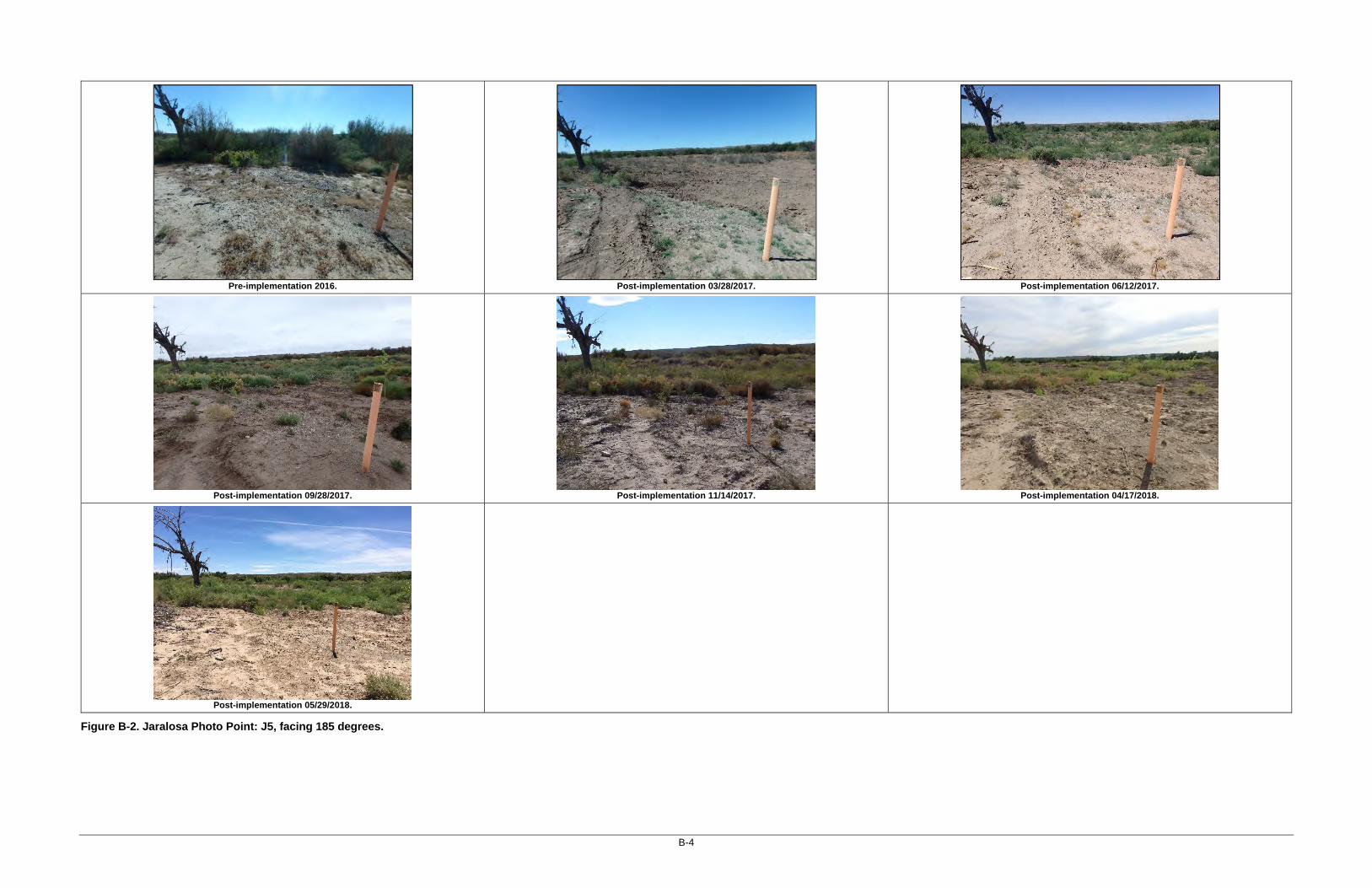
Figure B-2. Jaralosa Photo Point: J5, facing 185 degrees.

B-5
Pre-implementation 2016.
Post-implementation 03/28/2017.
Post-implementation 06/12/2017.
Post-implementation 09/28/2017.
Post-implementation 11/14/2017.
Post-implementation 04/17/2018.
Post-implementation 05/29/2018.
Figure B-3. Jaralosa Photo Point: J6, facing 145 degrees.

B-6
Pre-implementation 2016.
Post-implementation 03/28/2017.
Post-implementation 06/12/2017.
Post-implementation 09/28/2017.
Post-implementation 11/14/2017.
Post-implementation 04/17/2018.
Post-implementation 05/29/2018.
Figure B-4. Yeso East Photo Point: YE-MW-2, facing 215 degrees west.

B-7
Pre-implementation 2016.
Post-implementation 03/28/2017.
Post-implementation 06/12/2017.
Post-implementation 09/28/2017.
Post-implementation 11/14/2017.
Post-implementation 04/17/2018.
Post-implementation 05/29/2018.
Figure B-5. Yeso East Photo Point: YE-MW-3, facing 353 degrees north.

B-8
Pre-implementation 2016.
Post-implementation 03/28/2017.
Post-implementation 06/12/2017.
Post-implementation 09/28/2017.
Post-implementation 11/14/2017.
Post-implementation 04/17/2018.
Post-implementation 05/29/2018.
Figure B-6. Yeso East Photo Point: YE-2, facing 180 degrees south.

B-9
Pre-implementation 2016.
Post-implementation 03/28/2017.
Post-implementation 06/12/2017.
Post-implementation 09/28/2017.
Post-implementation 11/14/2017.
Post-implementation 04/17/2018.
Post-implementation 05/29/2018.
Figure B-7. Yeso West Photo Point: YW-1, facing 220 degrees, from across the river channel.

B-10
Pre-implementation 2016.
Post-implementation 03/28/2017.
Post-implementation 06/12/2017.
Post-implementation 05/29/2018.
Figure B-8. Yeso West Photo Point: YW-2, facing 270 degrees along river bank.

B-11
Pre-implementation 2016.
Post-implementation 03/28/2017.
Post-implementation 06/12/2017.
Post-implementation 04/17/2018.
Post-implementation 05/29/2018.
Figure B-9. Yeso West Photo Point: YW-3, facing 110 degrees south, along back fence.

B-12
Pre-implementation 2016.
Post-implementation 03/28/2017.
Post-implementation 06/12/2017.
Post-implementation 09/28/2017.
Post-implementation 11/14/2017.
Post-implementation 04/17/2018.
Post-implementation 05/29/2018.
Figure B-10. Crow Canyon C Photo Point: C1, facing 110 degrees southeast.

B-13
Pre-implementation 2016.
Post-implementation 03/28/2017.
Post-implementation 06/12/2017.
Post-implementation 09/28/2017.
Post-implementation 11/14/2017.
Post-implementation 04/17/2018.
Post-implementation 05/29/2018.
Figure B-11. Crow Canyon C Photo Point: C2, facing 165 degrees.

B-14
Pre-implementation 2016.
Post-implementation 03/28/2017.
Post-implementation 06/12/2017.
Post-implementation 09/28/2017.
Post-implementation 11/14/2017.
Post-implementation 04/17/2018.
Post-implementation 05/29/2018.
Figure B-12. Crow Canyon C Photo Point: C3, facing 165 degrees.

APPENDIX C
Planting Area Maps


C-1
Figure C-1. Jaralosa Planting Areas.

C-2
Figure C-2. Yeso East and West Planting Areas.

C-3
Figure C-3. Crow Canyon C Planting Areas.

C-4
This page intentionally left blank.

APPENDIX D
Restoration Plan


Riparian Habitat Restoration at Four Sites Riparian Habitat Restoration at Four Sites Riparian Habitat Restoration at Four Sites Riparian Habitat Restoration at Four Sites in Doña Ana County, New Mexico: in Doña Ana County, New Mexico: in Doña Ana County, New Mexico: in Doña Ana County, New Mexico: Jaralosa, Yeso East, Yeso West, and Crow Jaralosa, Yeso East, Yeso West, and Crow Jaralosa, Yeso East, Yeso West, and Crow Jaralosa, Yeso East, Yeso West, and Crow Canyon CCanyon CCanyon CCanyon C
Restoration PlaRestoration PlaRestoration PlaRestoration Plannnn
Prepared for:
U.S. International Boundary and Water Commission
Prepared by:
SWCA Environmental Consultants
January 2017

RIPARIAN HABITAT RESTORATION AT FOUR SITES IN DOÑA ANA COUNTY, NEW MEXICO: JARALOSA, YESO
EAST, YESO WEST, AND CROW CANYON C
RESTORATION PLAN
Prepared for:
International Boundary and Water Commission U.S. Section
4171 North Mesa, Suite C-100
El Paso, Texas 79902
Gulf South Research Corporation 8081 Innovation Park Drive
Baton Rouge, Louisiana 70820
Prepared by:
Conor Flynn, M.S.
Cody Stropki, Ph.D.
Brian Bader, M.S.
SWCA ENVIRONMENTAL CONSULTANTS 5647 Jefferson Street NE
Albuquerque, New Mexico 87109
January 27, 2017

Riparian Habitat Restoration at Four Sites in Dona Ana County, New Mexico –Restoration Plan
SWCA Environmental Consultants i January 2017
TABLE OF CONTENTS
INTRODUCTION ...................................................................................................................... 1
Site History .............................................................................................................................. 3
Existing Site Conditions .......................................................................................................... 3
Jaralosa ................................................................................................................................ 3
Yeso East ............................................................................................................................. 4
Yeso West ............................................................................................................................ 6
Crow Canyon C ................................................................................................................... 6
Restoration Techniques ........................................................................................................... 9
Site Preparation – Phase 1 ................................................................................................... 9
Native Plantings – Phase 2 ................................................................................................ 11
Site-Specific Restoration Plans ............................................................................................. 15
Jaralosa and Yeso East ...................................................................................................... 15
Yeso West .......................................................................................................................... 16
Crow Canyon C ................................................................................................................. 17
Erosion and Sediment Control Measures .............................................................................. 17
Monitoring and Maintenance ................................................................................................ 23
Monitoring Plan ................................................................................................................. 23
Post Restoration Maintenance ........................................................................................... 24
LITERATURE CITED ............................................................................................................. 25
APPENDIX A SITE PHOTOGRAPHS ............................................................................... 27
APPENDIX B IBWC MONITORING DATA FIELD SHEETS ........................................ 32
APPENDIX C PRE-CONSTRUCTION MONITORING DATA FIELD SHEETS ........... 37
LIST OF TABLES
Table 1. Summary of Restoration Sites ...................................................................................... 1
Table 2. Jaralosa Soil Electrical Conductivity (HDR EOC 2014) .............................................. 4
Table 3. Yeso East Soil Electrical Conductivity (HDR EOC 2014) .......................................... 5
Table 4. Vegetative Species Observed during Site Visits on October 20, 2016 across all 4 sites7
Table 5. Excavation and Bank Destabilization at Restoration Sites ......................................... 10
Table 6. Minimum Planting Quantities at Each Site ................................................................ 14
Table 7. Long-stem Shrub/Tree Species Planting Recommendations ...................................... 14
Table 8. Grass and Forb Species Recommendations ................................................................ 15
Table 9. Repeat Photodocumentation Coordinates ................................................................... 23
LIST OF FIGURES
Figure 1. Overview of the four Rio Grande Canalization Project restoration sites: Jaralosa, Yeso
East, Yeso West, and Crow Canyon C. .......................................................................................... 2
Figure 2. The conceptual planting design that will be used at all restoration sites (USDA 2007).12
Figure 3. High Desert Native Plants imprinter. ......................................................................... 15
Figure 4. Inset floodplain conceptual design. ............................................................................ 17
Figure 5. Jaralosa site planting plan. .......................................................................................... 19
Figure 6. Yeso East and Yeso West site planting plan. ............................................................. 20
Figure 7. Access roads to the Yeso West site. ........................................................................... 21
Figure 8. Crow Canyon C site planting plan. ............................................................................. 22

Riparian Habitat Restoration at Four Sites in Dona Ana County, New Mexico –Restoration Plan
SWCA Environmental Consultants ii January 2017

Riparian Habitat Restoration at Four Sites in Dona Ana County, New Mexico –Restoration Plan
SWCA Environmental Consultants 1 January 2017
INTRODUCTION
This plan describes the activities required to implement invasive species management and riparian
habitat restoration at four sites totaling 19.2 acres within the U.S. International Boundary Water
Commission’s (USIBWC’s) Rio Grande Canalization Project area. The four sites (Jaralosa, Yeso
East, Yeso West, and Crow Canyon C) are located north of Hatch, in Doña Ana County, New
Mexico (Figure 1).
The target habitats identified in the Conceptual Restoration Plan (U.S. Army Corps of Engineers
[USACE] 2009) and the Site Implementation Plan (TRC Environmental Corporation [TRC] 2011)
for the selected sites are open riparian woodland and dense riparian shrub (Table 1). The restoration
activities outlined and implemented will help improve the riparian zone, increasing suitable
feeding, breeding, and sheltering habitat for the southwestern willow flycatcher (Empidonax
traillii extimus; flycatcher) and the yellow-billed cuckoo (Coccyzus americanus).
Table 1. Summary of Restoration Sites
Site Acres Target Habitat Restoration Work Type
Jaralosa 4.5 Open riparian woodland Old river meander
Yeso East 9.7 Open riparian woodland Old river meander
Yeso West 1.6 Dense riparian shrub (flycatcher)
Creation of inset floodplain
Crow Canyon C 3.4 Dense riparian shrub (flycatcher)
Existing inset floodplain in need of enhancement
To increase habitat for these key species, non-native vegetation will be removed, and native trees
and shrubs will be planted. Habitat restoration will consist of creating willow (Salix sp.)–
dominated stands, a cottonwood (Populus deltoids spp. wislizeni) gallery forest, and a buffer area
planted with native riparian shrubs typical of the surrounding floodplain. All of the plantings will
be located in strategic locations in order to maximize the footprint of the existing native vegetation
(see Site-Specific Restoration Plans, below).

Riparian Habitat Restoration at Four Sites in Dona Ana County, New Mexico –Restoration Plan
SWCA Environmental Consultants 2 January 2017
Figure 1. Overview of the four Rio Grande Canalization Project restoration sites: Jaralosa, Yeso East, Yeso West, and Crow Canyon C.

Riparian Habitat Restoration at Four Sites in Dona Ana County, New Mexico –Restoration Plan
SWCA Environmental Consultants 3 January 2017
SITE HISTORY
All four restoration sites are within the historical floodplain of the Rio Grande, and two of the sites
(Jaralosa and Yeso East) contain abandoned meanders from before the Rio Grande was
channelized. The Rio Grande Canalization Project straightened and channelized the river, armored
the riverbanks, constructed levees, and cleared the floodplain of the existing mosaic of riparian
plant communities and wetlands (USIBWC 2016). These activities, coupled with the water
demand for irrigated agricultural and municipal use, have resulted in lowering of the groundwater
levels and disconnecting the floodplain from the river. Lowered groundwater levels and lack of
overbank flooding has limited the extent of the native riparian and wetland habitat throughout the
Rio Grande Canalization Project area, including the four selected restoration sites.
EXISTING SITE CONDITIONS
JARALOSA
The Jaralosa site (see Figure 1 and Figures A-1 and A-2 in Appendix A) contains a large, deep,
abandoned river meander and an abandoned irrigation return canal, along with over 1,400 feet of
river bank. Historically, this site has been mowed clean of all vegetation; however, mowing ceased
in 2011, which has allowed for both native and non-native species to colonize the area.
Three groundwater monitoring wells were established in 2013. Site visits to the wells have
recorded groundwater as shallow as 5 feet below ground surface (bgs) and as deep as 12 feet bgs,
with the greatest depth to groundwater recorded annually in May prior to irrigation releases. Well
JAR-MW-1 typically shows groundwater levels approximately 0.5 – 1 foot deeper than the other
two wells (USIBWC 2016).
Soils consist of Brazito loamy fine sand in the uplands and Anapra clay loam in the old meander
(TRC 2010). The upland soil is composed of loamy fine sand from 0 to 5 inches bgs, underlain by
deep, well drained sand grading to mixed alluvium. Due to the high sand content there is very low
available water capacity and very high soil blowing hazard. The root zone is from 10 to 24 inches
bgs. The old meander soil is composed of clay loam from 0 to 28 inches bgs, underlain by deep,
well drained sand grading to mixed alluvium. Due to the higher clay and loam content in the
surface horizons, the soil has moderate water capacity and moderate soil blowing hazard. The root
zone is 0 to 60 inches bgs.
Soils in the Jaralosa site are expected to be non-saline as classified by the Natural Resources
Conservation Service (NRCS) (Table 2), although some measurements border on the slightly
saline. As reported in HDR EOC (2014), non-saline soils have electrical conductivity (EC) less
than 2.0 microSiemens per centimeter (mS/cm), slightly saline soils range from 2.1 – 4.0 mS/cm.
Deeper profiles did not reveal elevated salinity, indicating that the moderate surface soil salinity
is primarily due to evaporation. TRC (2010) analyzed two samples in the project area, although
the exact locations were not reported. EC ranges from 2.23 to 4.70 mS/cm in the top 6 inches, and
0.02 to 5.06 mS/cm from 6 to 24 inches bgs.
These levels are near the lower end of Natural Resources Conservation Service (NRCS) moderate
soil salinity and would not be expected to affect plants with medium salt tolerance. Deeper profiles

Riparian Habitat Restoration at Four Sites in Dona Ana County, New Mexico –Restoration Plan
SWCA Environmental Consultants 4 January 2017
did not reveal elevated salinity, indicating that the moderate surface soil salinity is primarily due
to evaporation. Localized elevated salinity in the surface layers resulting from evaporation which
may impact surface seeding for saline intolerant species. Soil salinity should not impact the health
or vigor of deeper-rooted species.
Table 2. Jaralosa Soil Electrical Conductivity (HDR EOC 2014)
Sample Location
Depth Interval bgs (inches)
EC (mS/cm)
JAR-MW-1
0 – 6 1.641
7 – 24 1.711
25 – 48 0.047
JAR-MW-2
0 – 6 0.389
7 – 24 0.403
25 – 48 0.459
JAR-MW-3
0 – 6 1.651
7 – 24 1.893
25 – 48 0.390
The deep, abandoned meander contains thick vegetation. Patches of saltbush (Atriplex canescens),
honey mesquite (Prosopis glandulosa), southern goldenbush (Isocoma pluriflora), and sand
dropseed (Sporobolus cryptandrus) grow along the banks of the meander, while the bottom of the
meander has dense to sparse patches of honey mesquite and saltcedar (Tamarix sp.). There is a
small area of saltgrass (Distichlis spicata), but other native herbaceous growth is sparse in the old
meander. A thick stand of saltcedar grows along the river bank, along with forbs such as canaigre
dock (Rumex hymenosepalus), rough cocklebur (Xanthium strumarium), and Chinese thorn-apple
(Datura quercifolia). Grasses such as thin paspalum (Paspalum setaceum) and barnyardgrass
(Echinochloa crus-galli) also grow along the river bank. Coyote willow (Salix exigua) and
baccharis (Baccharis salicina) are present in low densities along the bank. Vegetation observed at
the Jaralosa site on the October 20, 2016, site visit is presented in Table 4.
No riprap was observed within the Jaralosa project reach, although it seems likely that riprap is
present on the old outlets to the meander.
YESO EAST
The Yeso East site contains a large, shallow, abandoned river meander along with over 1,750 feet
of river bank. Historically this site has been mowed of all vegetation; however mowing ceased in
2011, which has allowed for both native and non-native species to colonize the area. A single large
cottonwood tree has collapsed but is still living south of the old meander.
Three groundwater monitoring wells were established in 2013 at the Yeso East site (USIBWC
2016). Site visits to the wells have recorded groundwater as shallow as 3 feet bgs and as deep as
11 feet bgs, with the greatest depth to groundwater typically recorded in May prior to the irrigation
season. The depth to groundwater was variable between the three monitoring wells, but generally
Well YE-MW-2 typically shows groundwater levels approximately 1 foot deeper than YE-MW-
1, which is about 1 foot deeper than YE-MW-3. These groundwater depths appear to correlate with

Riparian Habitat Restoration at Four Sites in Dona Ana County, New Mexico –Restoration Plan
SWCA Environmental Consultants 5 January 2017
the relative ground-surface elevation of the old meander, which is lowest near the middle at YE-
MW-3.
Soils consist of Brazito loamy fine sand throughout the project area (TRC 2010). The soil is
composed of loamy fine sand from 0 to 5 inches bgs, underlain by deep, well drained sand grading
to mixed alluvium. Due to the high sand content there is very low available water capacity and
very high soil blowing hazard. The root zone is 10 to 24 inches bgs.
Soils in this project have low soil salinity. EC ranged from 0.034 mS/cm to 0.321 mS/cm (HDR
EOC 2014) (Table 3). One soils sample was analyzed in the project area, although the exact
location was not reported (TRC 2010). EC is 0.39 mS/cm in the top 6 inches, 0.66 mS/cm from 6
to 24 inches bgs, and 2.56 mS/cm from 24 to 39 inches bgs. The deeper profile test result is
problematic because it indicates that, at least in one location in the project area, elevated salinity
occurs in the rooting zone of shrubs and trees. However, the test result of 2.56 mS/cm is at the
lower end of salinity that may impact willow and cottonwood (Beauchamp et al. 2009).
Table 3. Yeso East Soil Electrical Conductivity (HDR EOC 2014)
Sample Location Depth Interval bgs
(inches) EC (mS/cm)
YE-MW-1
0 – 6 0.321
7 – 24 0.145
25 – 48 0.289
YE-MW-2
0 – 6 0.135
7 – 24 0.898
25 – 48 0.131
YE-MW-3
0 – 6 0.072
7 – 24 0.078
25 – 48 0.034
Weedy annuals, such as Palmer amaranth (Amaranthus palmeri) and annual grama grass
(Bouteloua barbinoides), cover large portions of the Yeso East site, with patches of arrowweed
(Pluchea sericea), saltbush, saltcedar, and bare ground. A few scattered honey mesquite are also
present. The perennial grass sand dropseed occurs in some areas, although most grasses are
annuals. Saltbush and Mormon tea (Ephedra torreyana) grow along the levee side of the site. A
few cottonwood trees occur in the middle of the site, between the river and the old meander.
Saltcedar grows in a thick band along the northern two-thirds of the riverside bank, with scattered
individuals throughout. A few velvet ash (Fraxinus velutina) and Siberian elm (Ulmus pumila) are
present interspersed in the saltcedar. Baccharis and thin paspalum grow at and just above the
ordinary high-water mark (OHWM). Vegetation observed during an October 20, 2016, site visit is
presented in Table 4.
We found no evidence of riprap on the upstream portion of the Yeso East site, although riprap is
present along the bank south of the site.

Riparian Habitat Restoration at Four Sites in Dona Ana County, New Mexico –Restoration Plan
SWCA Environmental Consultants 6 January 2017
YESO WEST
The Yeso West site occurs as an inset floodplain at a wide bend in the river. The site is dominated
by tall saltcedar and dense native riparian vegetation. Sedges and thin paspalum occur along the
low bank at the OHWM, while baccharis and saltcedar grow at higher elevations. Honey mesquite
and bare ground occur beyond the fence to the west of the site. A complete list of all vegetation
observed during an October 20, 2016, site visit is presented in Table 4.
No groundwater wells have been installed or soil tests performed at the Yeso West site.
Sections of a fence along the western boundary of the site will need to be temporarily removed to
facilitate access for saltcedar extraction and soil excavation.
CROW CANYON C
The Crow Canyon C site is on a river bench immediately downstream of the Hatch Siphon.
Historically, most of the site has been mowed of all vegetation; however mowing ceased in 2011,
which has allowed for both native and non-native species to colonize the site. The southern portion
of the site is on a lower bench that was not mowed, as evidenced by the thick riparian vegetation
there, which includes coyote willow, saltcedar, and Russian olive (Elaeagnus angustifolia).
A single groundwater monitoring well (CCB-MW-3) was established at the Crow Canyon C site
in 2013. Site visits to the well have recorded groundwater as shallow as 5.5 feet bgs and as deep
as 10.5 feet bgs (USIBWC 2016).
Although no soil tests were conducted at Crow Canyon C, it is likely that the soils in the area are
similar to the soils in Crow Canyon B, immediately upstream. Soils there consist of Agua variant
soils on lower benches along the river, and Brazito loamy fine sand on upper benches (TRC 2010).
The lower bench soil is composed of fine sandy loam from 0 to 28 inches bgs, underlain by deep,
somewhat poorly drained sand grading to mixed alluvium. Due to the high sand content, there is
very low available water capacity and high soil blowing hazard. The root zone is 25 to 35 inches
bgs. The upland soil is composed of loamy fine sand from 0 to 5 inches bgs, underlain by deep,
well drained sand grading to mixed alluvium. Due to the high sand content, there is very low
available water capacity and very high soil blowing hazard. The root zone is 10 to 24 inches bgs.
Boring logs for CCB-MW-3 indicate a silty sand from 0 – 1 feet, silty clay from 1 – 8 feet, and
poorly graded fine sand below 8 feet.
Soil EC measurements (HDR EOC 2014) at CCB-MW-3 indicate non-saline soils. EC ranged from
0.101 mS/cm at 0 – 6 inches, 0.094 at 7 – 24 inches, and 0.926 at 25 – 48 inches. Soil tests at
Crow Canyon B showed slightly elevated EC, 1.47 mS/cm in the top 6 inches of soil, but no
elevated test results in deeper layers, indicating that these high surface salinities are primarily due
to evaporation (TRC 2010). The low level of salinity is not likely to significantly affect seeding
efforts or willow and cottonwood pole establishment.
A thick coyote willow stand occurs along the return drain and the river bank at the north end of
the site. A large, sparsely vegetated area containing only annual weeds occurs between the willow
growth and the upland bench to the east of the site. The upland bench contains a diverse mix of

Riparian Habitat Restoration at Four Sites in Dona Ana County, New Mexico –Restoration Plan
SWCA Environmental Consultants 7 January 2017
annual weeds including tanseyleaf tansyaster (Machaeranthera tanacetifolia), Cuman ragweed
(Ambrosia psilostachya), stinkgrass (Eragrostis cilianensis), and needle grama (Bouteloua
aristoides), along with patches of saltcedar, saltbush, singlewhorl burrobush (Hymenoclea
monogyra), and honey mesquite. Most of the river bench is covered by saltcedar in patches and
dense stands. Streambed bristlegrass (Setaria leucopila) occurs through the saltcedar stands, along
with Palmer amaranth (Amaranthus palmeri), feather fingergrass (Chloris virgata), and scattered
individual alkali sacaton (Sporobolus airoides). Individual saltcedar also grow along the river
bank, interspersed with baccharis and American licorice (Glycyrrhiza lepidota). A few mature
cottonwoods trees occur along the back bench, although they have not recovered from drought
and/or frost damage. A dense stand of coyote willow is present on a lower bench on the southern
end of the site. Along the end of this bench, saltcedar trees grow up to 35 feet tall. Vegetation
observed during an October 20, 2016, site visit is presented in Table 4.
Table 4. Vegetative Species Observed during Site Visits on October 20, 2016 across all 4 sites
Common Name Scientific Name Family Native Status*
Palmer amaranth Amaranthus palmeri Amaranthaceae I
Skunkbush sumac Rhus trilobata Anacardiaceae N
Fringed twinevine Funastrum cynanchoides Asclepiadaceae N
Cuman ragweed Ambrosia psilostachya Asteraceae N
Willow baccharis Baccharis salicina Asteraceae N
Desert marigold Baileya multiradiata Asteraceae N
Broom snakeweed Gutierrezia sarothrae Asteraceae N
Singlewhorl burrobrush Hymenoclea monogyra Asteraceae N
Southern goldenbush Isocoma pluriflora Asteraceae N
Texas skeleton plant Lygodesmia texana Asteraceae N
Tanseyleaf tansyaster Machaeranthera tanacetifolia Asteraceae N
Lemonscent Pectis angustifolia Asteraceae N
Arrowweed Pluchea sericea Asteraceae N
Hopi tea greenthread Thelesperma megapotamicum Asteraceae N
Golden crownbeard Verbesina encelioides Asteraceae N
Rough cocklebur Xanthium strumarium Asteraceae N
Tulip pricklypear Opuntia phaeacantha Cactaceae N
Fourwing saltbush Atriplex canescens Chenopodiaceae N
Burningbush Bassia scoparia Chenopodiaceae I
Prickly Russian thistle Salsola tragus Chenopodiaceae I
Desert seepweed Suaeda nigra Chenopodiaceae N
Missouri gourd Cucurbita foetidissima Cucurbitaceae N
Hardstem bulrush Schoenoplectus acutus Cyperaceae N
Russian olive Elaeagnus angustifolia Elaeagnaceae I
Torrey's jointfir Ephedra torreyana Ephedraceae N
Whitethorn acacia Acacia constricta Fabaceae N
White prairie clover Dalea candida Fabaceae N

Riparian Habitat Restoration at Four Sites in Dona Ana County, New Mexico –Restoration Plan
SWCA Environmental Consultants 8 January 2017
Common Name Scientific Name Family Native Status*
Woolly prairie clover Dalea lanata Fabaceae N
American licorice Glycyrrhiza lepidota Fabaceae N
Honey mesquite Prosopis glandulosa Fabaceae N
Screwbean mesquite Prosopis pubescens Fabaceae N
Broom dalea Psorothamnus scoparius Fabaceae N
Bristly nama Nama hispidum Hydrophyllaceae N
Manystem blazingstar Mentzelia multicaulis Loasaceae N
Copper globemallow Sphaeralcea angustifolia Malvaceae N
Fivewing spiderling Boerhavia intermedia Nyctaginaceae N
Velvet (Arizona) ash Fraxinus velutina Oleaceae N
Velvetweed Gaura mollis Onagraceae N
New Mexico evening primrose Oenothera neomexicana Onagraceae N
Giant reed Arundo donax Poaceae I
Needle grama Bouteloua aristidoides Poaceae N
Sixweeks grama Bouteloua barbata Poaceae N
Feather fingergrass Chloris virgata Poaceae I
Low woollygrass Dasyochloa pulchella Poaceae N
Saltgrass Distichlis spicata Poaceae N
Barnyardgrass Echinochloa crus-galli Poaceae I
Stinkgrass Eragrostis cilianensis Poaceae I
Vine mesquite Panicum obtusum Poaceae N
Thin paspalum Paspalum setaceum Poaceae N
Streambed bristlegrass Setaria leucopila Poaceae N
Alkali sacaton Sporobolus airoides Poaceae N
Spike dropseed Sporobolus contractus Poaceae N
Sand dropseed Sporobolus cryptandrus Poaceae N
Mesa dropseed Sporobolus flexuosus Poaceae N
Flaxflowered ipomopsis Ipomopsis longiflora Polemoniaceae N
Abert's buckwheat Eriogonum abertianum Polygonaceae N
Canaigre dock Rumex hymenosepalus Polygonaceae N
Kiss me quick Portulaca pilosa Portulacaceae N
Rio Grande cottonwood Populus deltoides ssp. wislizeni Salicaceae N
Chinese thorn-apple Datura quercifolia Solanaceae N
Pale desert-thorn Lycium pallidum Solanaceae N
Silverleaf nightshade Solanum elaeagnifolium Solanaceae I
Five-stamen tamarisk Tamarix chinensis Tamaricaceae I
Narrowleaf cattail Typha angustifolia Typhaceae I
Note: The four restoration sites have similar species composition. * I=Non-native, N=Native.

Riparian Habitat Restoration at Four Sites in Dona Ana County, New Mexico –Restoration Plan
SWCA Environmental Consultants 9 January 2017
RESTORATION TECHNIQUES
Restoration work will consist of removing and disposing of invasive vegetation; bank
destabilization and excavation to improve planting area depth to groundwater; and planting native
tree poles, long-stem native riparian shrubs, and a native grass/forbs seed mix.
SITE PREPARATION – PHASE 1
The USIBWC Rio Grande Canalization Project River Management Plan (USIBWC 2014) calls
for USIBWC to “help ensure the long-term persistence of riparian habitats and associated species
by removing and controlling invasive species, primarily saltcedar” (USIBWC 2014:2-11).
Invasive Species Management. Saltcedar will be removed through excavation with the
disposal of the woody biomass done by mastication. Extraction will be performed using a clasping
thumb attachment fitted on an excavator to completely remove the entire shrub/tree along with its
root ball (SWCA Environmental Consultants [SWCA] 2011 and USIBWC 2014). Care will be
taken to remove as much of the root crown and lateral roots as possible while avoiding damage to
existing native plants. In some areas, aerial stems of baccharis or honey mesquite may be damaged
by extraction efforts; however, these species regrow quickly following disturbance. There may be
some cases where extraction of neighboring native shrub root crowns may be unavoidable when
extracting saltcedar root crowns.
The extracted saltcedar will be placed in windrows and masticated on-site. Mastication involves
grinding woody biomass to a coarse wood chip consistency using a specially designed machine.
Mastication will be conducted in specified areas to avoid smothering native vegetation or impeding
planting efforts. Specified areas will include areas with low total vegetative cover to provide a
moisture-retaining and erosion-inhibiting mulch.
Heavy equipment will be used to accomplish extraction of the saltcedar. Best management
practices (as described in SWCA 2011) and informed by SWCA’s and the contractor’s extensive
experience conducting riparian restoration, will include:
• Water Resources Protection: All woody debris, as a result of saltcedar reduction, will be
mulched and removed from the floodway.
• Soil Protection: Heavy equipment used for brush reduction will minimize impacts to native
brush.
• Soil Protection: Mechanical treatment, including extraction, mastication, and excavation,
will be conducted in weather conditions that provide for drier soil conditions to avoid
creating ruts and compacting soil. (Due to the sandy soils present in the project area,
compaction is not expected to present a serious problem.)
Foliar or basal application of herbicide may be employed in follow-up treatments in subsequent
years. Field surveys in October 2016 noted the presence of saltcedar beetle (Diorhabda carinulata)
in the project area, which should facilitate resprouting saltcedar control via defoliation. SWCA
recommends monitoring saltcedar beetle defoliation of resprouting saltcedar in the first growing

Riparian Habitat Restoration at Four Sites in Dona Ana County, New Mexico –Restoration Plan
SWCA Environmental Consultants 10 January 2017
season following project implementation, followed by herbicide application in subsequent years if
needed.
A total of 9.7 acres of saltcedar, according to field delineation and geographic information system
(GIS) calculation, will be removed from the four restoration sites (see Figure 5, Figure 6, and
Figure 8).
Floodplain and Swale Excavation
Simultaneous with saltcedar removal, the contractor will excavate swales in the old meanders at
the Jaralosa and Yeso East sites to decrease the depth to groundwater to approximately 8 to 9 feet
bgs and increase the area suitable for planting native vegetation. An inset floodplain will be created
at the Yeso West site. No excavation will occur at the Crow Canyon C site. Table 5 summarizes
the excavation and bank destabilization quantities at each site.
At the Yeso East site, a swale could be constructed to enable future flood irrigation via the existing
Palmer Lateral Wasteway, which traverses the upstream end of the site. The Conceptual
Restoration Plan (USACE 2009) calls for a simple check dam in the wasteway to raise the water
surface and allow inundation of the swale via a turnout). The swale could be excavated to connect
to the wasteway to facilitate gravity water movement from the northern end at the wasteway
turnout to the southern end of the excavated area. Some of the spoil from the swale excavation
could be used to construct the check dam, as well as raise the banks of the wasteway, if needed.
The exact design of the check dam and turnout will be determined in consultation with the
USIBWC.
The USACE has issued a preliminary jurisdictional determination (Action No. SPA-2012-00529-
LCO). Excavation will not result in any discharge of dredged or fill material into Waters of the
U.S, including wetlands, nor will it affect navigable waterways. No excavation equipment will
operate in the river. Therefore, the Project will not require Department of Army authorization
under Section 404 of the Clean Water act and Section 10 of the rivers and Harbors Act of 1899.
Table 5. Excavation and Bank Destabilization at Restoration Sites
Site Estimated
Volume (cubic yards)
Dimensions (feet) Type of Work Erosion Control BMPs
Jaralosa 650 1.7 acres × 4.2 feet deep
Excavation of swales within old river meander
Flag perimeter, leave native vegetation, maintain buffer from river, install silt fence when working along water interface
Yeso East 800 3.25 acres × 6.5 feet deep
Excavation of swales within old river meander
Flag perimeter, leave native vegetation, maintain buffer from river, install silt fence when working along water interface
Yeso West 6,000 40 × 1,000 × 4 feet (width × length × depth)
Floodplain excavation
Flag perimeter and OHWM, leave native vegetation, maintain
Riparian Habitat Restoration at Four Sites in Dona Ana County, New Mexico –Restoration Plan
SWCA Environmental Consultants 11 January 2017
buffer from river, install silt fence when working along water interface
Crow Canyon C
N/A N/A N/A
Flag perimeter, leave native vegetation, maintain buffer from river.
Modifications from the Implementation Plan
Bank destabilization will not be completed at the Yeso East and Jaralosa sites, as was called for in
the Conceptual Restoration Plan (USACE 2009). The original purpose of bank destabilization was
to encourage channel migration. However, the excavation specifications recommended in the
Conceptual Restoration Plan (25 × 1,400 × 0.05 feet) along the bankline are insufficient to
encourage channel migration. This was recognized in the Rio Grande Canalization Project River
Restoration Implementation Plan (TRC 2011), which recommended grading to a 4:1 slope over
25 feet instead. After consultation with the USIBWC, this requirement was changed to decrease
the depth to groundwater as described above.
NATIVE PLANTINGS – PHASE 2
Following invasive species removal, native trees, long-stemmed riparian shrubs, and a native
grass/forb seeds will be used to revegetate disturbed areas at all sites. SWCA will follow the
preferred methods for planting native trees and shrubs established by the Los Lunas Plant Materials
Center (Dreesen et al. 2002; NRCS 2009a, 2009b, 2009c). These methods have the advantage of
minimizing watering requirements leading to successful establishment. The key to successful
establishment of native riparian trees and shrubs is establishing a connection to the groundwater
table (Figure 2).

Riparian Habitat Restoration at Four Sites in Dona Ana County, New Mexico –Restoration Plan
SWCA Environmental Consultants 12 January 2017
Figure 2. The conceptual planting design that will be used at all restoration sites (USDA 2007).
Planting is scheduled to be completed in late February – early March 2017. Planting depth will be
informed by the documented variability (2013–2015) of groundwater depth; groundwater depth
has been observed to drop through May when flow in the river resumes. Poles will be watered at
least once in the first season after planting during the critical leafing-out period (March 15 to April
15), but prior to irrigation releases, in order to promote root growth and plant vigor. At least 5
gallons of water will be used per tree or planting hole.
Coyote willow patches for the flycatcher should be at least 0.25 acre in size, or about 200 × 200
feet, interspersed with herbaceous/low shrub growth. Patches should not be less than 30 feet wide.
Flycatchers forage within and above the canopy, along patch edges, in openings within the
territory, above water, and glean from tall trees as well as herbaceous ground cover (U.S. Fish and
Wildlife Service [USFWS] 2002). Therefore, shrubs and forbs that attract pollinator insects will
be selected to provide foraging opportunities for the flycatcher.
Moore (2015) has shown that higher tree-stem density is better for nesting (i.e., 1,100 stems/acre).
Both low- and mid-canopy density is important; nesting is correlated with the presence of larger
trees (10 to 20 centimeters diameter at breast height [DBH]) that reach into the mid-canopy. Coyote
willows rarely exceed 5 cm DBH and are restricted to the lower canopy, so the presence of
Goodding's willow (Salix gooddingii) or other mid-stature trees interspersed with coyote willow
is critical.

Riparian Habitat Restoration at Four Sites in Dona Ana County, New Mexico –Restoration Plan
SWCA Environmental Consultants 13 January 2017
Breeding success and fecundity (number of eggs) is greatest at sites that are flooded. In general,
nesting sites with more soil moisture and less distance to water are more productive for flycatcher
nesting (USFWS 2002).
Mixed cottonwood and Goodding’s willow copses or swales are designed to benefit yellow-billed
cuckoos, which prefer to nest in open woodlands with an understory of dense vegetation (Wiggins
2005). In the desert Southwest, nesting habitat is invariably riparian woodlands, particularly those
with an intact (i.e., ungrazed) understory. The nests are typically placed in dense patches of broad-
leaved deciduous trees, usually with a relatively thick understory.
Coyote willow poles will be placed in excavated swales using the trenching technique. Trenches
would be selectively excavated to reach the desired depth to groundwater. Coyote willow poles
would be placed at a density of approximately 1 pole/stem per foot. Coyote willows will colonize
the site through clonal growth to form dense patches.
Cottonwood and Goodding’s willow will also be planted with the use of an auger at the end of an
excavator arm in a patchy distribution, to avoid an orchard appearance. Some poles may be planted
into existing shrub communities (e.g., mesquite, arrowweed), which may result in incidental
damage to the existing shrubs during the planting process. However, established native shrubs can
regrow quickly following non-lethal damage. Existing native shrubs will be flagged during
planting to prevent excess damage. Augured holes will be filled to almost level with the soil
surface, leaving a basin surrounding the pole to facilitate directed watering. Planting quantities are
specified in Table 6.

Riparian Habitat Restoration at Four Sites in Dona Ana County, New Mexico –Restoration Plan
SWCA Environmental Consultants 14 January 2017
Table 6. Minimum Planting Quantities at Each Site
Site Grass and
Forb Seeding (acres)
Coyote Willow Poles
Goodding’s Willow Poles
Cottonwood Poles
Longstem Riparian Shrubs
Coyote Willow
Bankline
Jaralosa 4.5 0 100 60 50 1000
Yeso East 9.7 800 50 485 485
Yeso West 0 1,000 50 20 0
Crow Canyon C
0 2,100 400 100 35
Total 14.2 3,900 600 665 570
Long-stem shrubs will be planted in and around the margins of constructed swales to create a thick
understory, using an auger attached to an excavator or small skid steer. Native long-stem riparian
shrubs will be planted with dri-water, terra-sorb, or equivalent product to maintain moisture around
the roots during the critical establishment period. Watering will be conducted twice from March
15 to July 15, with at least 2 gallons of water per shrub per visit. Access roads will be maintained
to facilitate watering with a water truck.
Long-stem shrubs will be planted in and around the margins of constructed swales to create a thick
understory. Shrubs will also be planted in association with cottonwood and Goodding’s willow
trees, with preference given to species that can survive drier or shaded sites, depending on planting
location (Table 7). All planted long-stem shrubs will be flagged (with a different color than existing
shrubs) to facilitate monitoring.
Table 7. Long-stem Shrub/Tree Species Planting Recommendations
Common Name Scientific Name Family
Baccharis Baccharis salicifolia/salicina Asteraceae
Desert willow Chilopsis linearis Bignoniaceae
Fourwing saltbush Atriplex canescens Chenopodiaceae
Skunkbush sumac Rhus trilobata Anacardiaceae
Velvet (Arizona) Ash* Fraxinus velutina Oleaceae
*If available
Seeding with native grass and forb species will be accomplished using an imprinter to create
favorable microsites for germination and establishment, according to protocols developed
successfully by High Desert Native Plants (Figure 3). Seeding will occur immediately following
pole and long-stem shrub planting, and will be focused on areas with disturbed soil created by
saltcedar removal and planting earthmoving. The seeding plan does not currently call for mulch
use although this may be included, if warranted. Seeds may also be scattered directly into swales
and basins and other areas not reachable by the imprinter. These areas can create “islands” of
favorable conditions, from which rhizomatous or self-seeding species can spread out across the
project area (Dreesen et al. 2006).

Riparian Habitat Restoration at Four Sites in Dona Ana County, New Mexico –Restoration Plan
SWCA Environmental Consultants 15 January 2017
Figure 3. High Desert Native Plants imprinter.
Native grass and forb species will be selected for vigor, pollinator suitability, and local seed
availability. Table 8 provides a list of suggested species.
Table 8. Grass and Forb Species Recommendations
Common Name Scientific Name Family
Desert marigold Baileya multiradiata Asteraceae
Common sunflower Helianthus annuus Asteraceae
Woolly paperflower Psilostrophe tagetina Asteraceae
Redwhisker clammyweed Polanisia dodecandra Cleomaceae
Wooly prairie clover Dalea lanata Fabaceae
Indian ricegrass Achnatherum hymenoides Poaceae
Saltgrass Distichlis spicata Poaceae
Scratchgrass Muhlenbergia asperifolia Poaceae
Tobosagrass Pleuraphis mutica Poaceae
Alkali sacaton Sporobolus airoides Poaceae
Penstemon Penstemon sp. Scrophulariaceae
SITE-SPECIFIC RESTORATION PLANS
JARALOSA AND YESO EAST
Access will be through the levee road. Access roads along the bank will be left intact, unless
otherwise directed to remove by the US IBWC. Saltcedar will be removed in the abandoned
meander and along the river bankline. Extracted biomass will be windrowed in specified areas and
masticated on-site to create mulch and promote moist soil conditions. Selected areas within the
abandoned meander will be excavated to create a swale. By decreasing the depth to groundwater,
the swale will facilitate planting success for cottonwood trees and Goodding’s willow poles. This

Riparian Habitat Restoration at Four Sites in Dona Ana County, New Mexico –Restoration Plan
SWCA Environmental Consultants 16 January 2017
swale in the abandoned meander will reduce depth to groundwater and facilitate planting
phreatophytes into deep groundwater. Phreatophytes are plants, like cottonwood and willow that
require contact with groundwater. Existing native shrub patches will be retained by auguring single
cottonwood and Goodding’s willow poles into these areas.
Trees and shrubs will be planted according to the quantities listed in Table 6. Long-stemmed
riparian shrub species will be selected from the species recommended in Table 7. All disturbed
areas will be imprinted and seeded with the grass/seed mix specified in Table 8.
Planting will be designed to create structural habitat elements and structural diversity. Goodding’s
willow and cottonwood will be planted using trenching in the excavated swale habitats. Plantings
will be determined by location of plantable-depth water table via test auger holes. High spots (not
visible on LIDAR) will be avoided; however, shrubs that are more drought-tolerant will be planted
on the on-swale slopes. Coyote willow (1,000 stems) will be planted along the river bankline in
the area disturbed by saltcedar extraction at the Jaralosa site. Planting plans are presented in Figure
5 and Figure 6.
YESO WEST
Access will be along levee roads on the western side of the river, accessed from Road 391. (Drive
5 miles north and across the Yeso arroyo to enter the area west of the project area [Figure 7]). The
fence line along the western boundary of the site will need to be removed to facilitate access. The
site will be cleared of invasive saltcedar, and the extracted biomass windrowed in specified areas
(west of the existing fence line) and masticated. Soil within the site will be excavated
approximately 4 feet and graded to create an inset floodplain. The perimeter of the inset floodplain
will be graded to an approximately 3:1 or 4:1 slope. See Figure 4 for a schematic design of the
inset floodplain. Excavation will not be conducted below the OHWM. Coyote willow and
Goodding’s willow will be planted on the inset floodplain. Planting will be accomplished
according to Table 6. No grass/forb seeds or long-stem shrubs will be planted. The Yeso West site
planting plan is illustrated in Figure 6.

Riparian Habitat Restoration at Four Sites in Dona Ana County, New Mexico –Restoration Plan
SWCA Environmental Consultants 17 January 2017
Figure 4. Inset floodplain conceptual design (USACE 2009).
CROW CANYON C
Access roads will be left intact. Saltcedar will be removed throughout the site. Extracted biomass
will be windrowed in specified areas on the bench to the east of the project area and then
masticated. Trees and shrubs will be planted according to the quantities listed in Table 6. Species
will be selected from the species planting recommendations (see Table 7). All disturbed areas will
be imprinted and seeded with the grass/seed mix specified in Table 8.
Planting will be designed to create structural habitat elements and structural diversity. Plantings
will grade from the southern end of the site where swales will be trenched to plant coyote willow
and Goodding’s willow, to the drier northern end of the site where Goodding’s willow and
cottonwood will be planted in augered holes. Plantings will be determined by location of plantable-
depth water table via test auger holes. High spots (not visible on LIDAR) will be avoided. Shade-
tolerant shrubs will be located under the existing cottonwood canopy. The Crow Canyon C
planting plan is presented in Figure 8.
EROSION AND SEDIMENT CONTROL MEASURES
In compliance with the Clean Water Act Section 402 – National Pollutant Discharge Elimination
System (NPDES) and other federal regulations, SWCA and GSRC have prepared a Stormwater
Pollution Prevention Plan (SWPPP). The goals of the SWPPP include:
1. Identify potential sources of pollutants that affect storm water discharges from the site;
2. Implement best management practices (BMPs) to prevent erosion and sedimentation, and
to identify, reduce, eliminate or prevent storm water contamination; and

Riparian Habitat Restoration at Four Sites in Dona Ana County, New Mexico –Restoration Plan
SWCA Environmental Consultants 18 January 2017
3. Create an implementation schedule to ensure that the practices described in this SWPPP
are in fact implemented and to evaluate the plan’s effectiveness in reducing the pollutant
levels in storm water discharges.
The following BMPs will be implemented:
• Demarcating the perimeter of all areas to be disturbed and limiting the area of disturbance
• Preserving Natural Vegetation
• Maintaining buffer areas around waterways
• Installing silt fence when working along the water interface
• Revegetating disturbed areas with native vegetation
• Refueling and conducting equipment maintenance a minimum of 100 feet from waterways
• Maintaining spill kits in excavation equipment
• Staff training
• Monitoring

Riparian Habitat Restoration at Four Sites in Dona Ana County, New Mexico –Restoration Plan
SWCA Environmental Consultants 19 January 2017
Figure 5. Jaralosa site planting plan.

Riparian Habitat Restoration at Four Sites in Dona Ana County, New Mexico –Restoration Plan
SWCA Environmental Consultants 20 January 2017
Figure 6. Yeso East and Yeso West site planting plan.

Riparian Habitat Restoration at Four Sites in Dona Ana County, New Mexico –Restoration Plan
SWCA Environmental Consultants 21 January 2017
Figure 7. Access roads to the Yeso West site.

Riparian Habitat Restoration at Four Sites in Dona Ana County, New Mexico –Restoration Plan
SWCA Environmental Consultants 22 January 2017
Figure 8. Crow Canyon C site planting plan.

Riparian Habitat Restoration at Four Sites in Dona Ana County, New Mexico –Restoration Plan
SWCA Environmental Consultants 23 January 2017
MONITORING AND MAINTENANCE
MONITORING PLAN
Pre-construction monitoring was conducted on October 19 and 20, 2016 with the groundwater
wells being measured on November 16, 2016. Monitoring consisted of establishing repeat
photodocumentation points, qualitatively assessing the existing vegetation present at each site, and
collecting groundwater data at UWIBWC groundwater monitoring wells.
Repeat photodocumentation points were established near monitoring wells and/or USIBWC
delineator posts during pre-construction monitoring (Table 9). Appendix A contains some of the
photographs taken at the photo monitoring points in October 2016. Repeat photos will be collected
at each site visit (described below) and transmitted to USIBWC with appropriate file names and
metadata.
Table 9. Repeat Photodocumentation Coordinates
Site Latitude Longitude Location Notes
Jaralosa
32.749202 -107.284163
32.749307 -107.284453 JARMW-2
32.747912 -107.283437 JARMW-3
32.747763 -107.28319 IBWC Sign
32.74683 -107.283244 IBWC Sign
32.747147 -107.283258 IBWC Sign
32.749467 -107.285196
Yeso East
32.737246 -107.277046 IBWC Sign
32.735728 -107.273723 Levee Road (survey monument)
32.736131 -107.27459 YEMW-3
32.734541 -107.27425 YEMW-2
Yeso West
32.732125 -107.274127 Along river bank
32.734603 -107.276119 Along back fence
32.734006 -107.27431 View from Yeso East looking across the river
Crow Canyon C 32.701382 -107.245578
32.70081 -107.244467
32.700068 -107.243206
Vegetation monitoring will be conducted during and after planting in order to document success
of native species plantings and identify any regrowth of invasive species. Each site will be revisited
a minimum of six times following completion of restoration work, with the exact schedule of visits
to be coordinated with USIBWC. The preliminary schedule suggested by the USIBWC includes
April, July, and October 2017, and February, April, and July 2018. USIBWC datasheets (Appendix
B) will be used to ensure standard data collection methods.

Riparian Habitat Restoration at Four Sites in Dona Ana County, New Mexico –Restoration Plan
SWCA Environmental Consultants 24 January 2017
Groundwater monitoring wells will also be measured during each site visit. A Solinst water level
meter will be used to collect water elevations to the nearest tenth of a foot. Data will be collected
on IBWC data sheets and transmitted to USIBWC.
Pre-Construction monitoring field data are presented in Appendix C.
POST RESTORATION MAINTENANCE
In accordance with the Statement of Work, post-restoration maintenance will consist of the
following:
• Replanting if mortality exceeds 15% of the total number of poles and shrubs planted.
• Treating saltcedar resprouts.
Replanting will be based on the results of the vegetation monitoring. If the results of the October
monitoring suggest a mortality of greater than 15% for all planted poles and longstem shrubs,
GSRC along with SWCA and High Desert Native Plant Nursery will coordinate with the UW
IBWC. One option to be explored may include planting the longstem shrubs in the fall. The
advantage of this planting period for the longstem shrubs includes higher groundwater table and
lower temperatures, which results in reduced transpiration stress.
Saltcedar resprouts will be noted during monitoring. Prior to treating as described above, GSRC
and SWCA will coordinate with the US IBWC.
Riparian Habitat Restoration at Four Sites in Dona Ana County, New Mexico –Restoration Plan
SWCA Environmental Consultants 25 January 2017
LITERATURE CITED
Beauchamp, V.B., C. Walz, and P.B. Shafroth. 2009. Salinity tolerance and mycorrhizal
responsiveness of native xeroriparian plants in semi-arid western USA. Applied Soil
Ecology 43.2:175–184.
Dreesen, D.R., G.A. Fenchel, D.G. Goodson, and K. White. 2002. Southwest Riparian
Restoration Considerations: New Stock Types, Planting Methods, and Site Limitations.
Los Lunas, New Mexico: Natural Resources Conservation Service Plant Materials
Center.
———. 2006. Seeding Xeric Riparian Sites Following Removal of Invasive Phreatophytes. Los
Lunas, New Mexico: Natural Resources Conservation Service Plant Materials Center.
HDR EOC. 2014. Groundwater Monitoring Well Installation and Groundwater Level
Monitoring Report – Rio Grande Canalization Project Restoration Sites. Prepared for
U.S. International Boundary Water Commission, El Paso, Texas.
Moore, S.D. 2015. Southwestern Willow Flycatcher Studies within the Rio Grande Basin, New
Mexico. Denver, Colorado: U.S. Bureau of Reclamation, Denver Technical Service
Center.
Natural Resources Conservation Service (NRCS). 2007. A Guide for Planning Riparian
Treatments in New Mexico. Available at:
https://www.nrcs.usda.gov/Internet/FSE_PLANTMATERIALS/publications/nmpmcpg76
85.pdf. Accessed January 30, 2017.
Natural Resources Conservation Service (NRCS). 2009a. Guidelines for Planting Longstem
Transplants for Riparian Restoration in the Southwest. Available at:
https://www.nrcs.usda.gov/Internet/FSE_PLANTMATERIALS/publications/nmpmcbr71
06.pdf. Accessed October 31, 2016.
———. 2009b. Guidelines for Planting Dormant Whip Cuttings to Revegetate and Stabilize
Streambanks. Available at: http://www.tamariskcoalition.org/sites/default/files/resource-
center-documents/Guidelines_for_Planting_Dormant_Whip_Cuttings.pdf. Accessed
October 31, 2016.
———. 2009c. The Pole Cutting Solution. Available at:
http://allaboutwatersheds.org/library/general-library-holdings/polecutting.pdf/view.
Accessed October 31, 2016.
SWCA Environmental Consultants (SWCA). 2011. Final Biological Assessment – Integrated
Land Management for Long-Term River Management of the Rio Grande Canalization
Project. Prepared for United States Section, International Boundary Water Commission.
SWCA Environmental Consultants, in association with MWH Americas. Available at:
http://www.ibwc.gov/EMD/documents/Final_IBWC_RGCP_BA2011.pdf. Accessed
October 31, 2016.

Riparian Habitat Restoration at Four Sites in Dona Ana County, New Mexico –Restoration Plan
SWCA Environmental Consultants 26 January 2017
TRC Environmental Corporation (TRC). 2010. Soil Survey Resource Report for Rio Grande
Canalization Implementation Plan. Prepared for U.S. International Boundary Water
Commission, El Paso, Texas.
———. 2011. Site Implementation Plans ‐ Rio Grande Canalization Project River Restoration
Implementation Plan. Prepared for U.S. International Boundary Water Commission.
U.S. Army Corps of Engineers (USACE). 2009. Conceptual Restoration Plan and Cumulative
Effects Analysis, Rio Grande ‐ Caballo Dam to America Dam, New Mexico and Texas.
Albuquerque, New Mexico: U.S. Army Corps of Engineers, Albuquerque District, with
Mussetter Engineering Inc. and Riada Engineering, Inc.
U.S. Fish and Wildlife Service (USFWS). 2002. Final Recovery Plan – Southwestern Willow
Flycatcher (Empidonax traillii extimus). Prepared by Southwestern Willow Flycatcher
Recovery Team Technical Subgroup. Albuquerque, New Mexico: U.S. Fish and Wildlife
Service, Region 2.
U.S. International Boundary Water Commission (USIBWC). 2014. Rio Grande Canalization
Project River Management Plan. Available at:
http://www.ibwc.gov/Files/Canalization_River_Management_Plan_112014.pdf.
Accessed October 31, 2016.
———. 2016. Attachment 7 – Groundwater Monitoring Data.
Wiggins, D. 2005. Yellow-billed Cuckoo (Coccyzus americanus): A Technical Conservation
Assessment. Golden, Colorado: U.S. Forest Service, Rocky Mountain Region.

Riparian Habitat Restoration at Four Sites in Dona Ana County, New Mexico –Restoration Plan
SWCA Environmental Consultants 27 January 2017
APPENDIX A SITE PHOTOGRAPHS

Riparian Habitat Restoration at Four Sites in Dona Ana County, New Mexico –Restoration Plan
SWCA Environmental Consultants 28 January 2017
Figure A.1. Jaralosa repeat photo point J4. Looking west, this photo point overlooks the old meander.
Figure A.2. Jaralosa bankside, looking upstream (north) from the southern end of the site.

Riparian Habitat Restoration at Four Sites in Dona Ana County, New Mexico –Restoration Plan
SWCA Environmental Consultants 29 January 2017
Figure A.3. Yeso East repeat photo point Y1 looking west at USIBWC sign and old meander. River bankline visible in the background.
Figure A.4. Yeso East repeat photo point Y2 from levee road looking west at old meander.
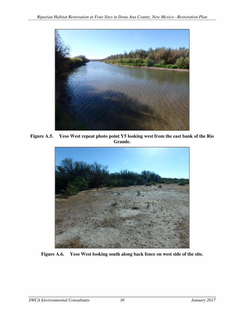
Riparian Habitat Restoration at Four Sites in Dona Ana County, New Mexico –Restoration Plan
SWCA Environmental Consultants 30 January 2017
Figure A.5. Yeso West repeat photo point Y5 looking west from the east bank of the Rio Grande.
Figure A.6. Yeso West looking south along back fence on west side of the site.

Riparian Habitat Restoration at Four Sites in Dona Ana County, New Mexico –Restoration Plan
SWCA Environmental Consultants 31 January 2017
Figure A.7. Crow Canyon C repeat photo point C2 looking west at monitoring well and planting area.
Figure A.8. Crow Canyon C repeat photo point C3 looking south.

Riparian Habitat Restoration at Four Sites in Dona Ana County, New Mexico –Restoration Plan
SWCA Environmental Consultants 32 January 2017
APPENDIX B IBWC MONITORING DATA FIELD SHEETS

Riparian Habitat Restoration at Four Sites in Dona Ana County, New Mexico –Restoration Plan
SWCA Environmental Consultants 33 January 2017

Riparian Habitat Restoration at Four Sites in Dona Ana County, New Mexico –Restoration Plan
SWCA Environmental Consultants 34 January 2017

Riparian Habitat Restoration at Four Sites in Dona Ana County, New Mexico –Restoration Plan
SWCA Environmental Consultants 35 January 2017

Riparian Habitat Restoration at Four Sites in Dona Ana County, New Mexico –Restoration Plan
SWCA Environmental Consultants 36 January 2017

Riparian Habitat Restoration at Four Sites in Dona Ana County, New Mexico –Restoration Plan
SWCA Environmental Consultants 37 January 2017
APPENDIX C PRE-CONSTRUCTION MONITORING DATA FIELD SHEETS

Riparian Habitat Restoration at Four Sites in Dona Ana County, New Mexico –Restoration Plan
SWCA Environmental Consultants 38 January 2017

Riparian Habitat Restoration at Four Sites in Dona Ana County, New Mexico –Restoration Plan
SWCA Environmental Consultants 39 January 2017

Riparian Habitat Restoration at Four Sites in Dona Ana County, New Mexico –Restoration Plan
SWCA Environmental Consultants 40 January 2017

Riparian Habitat Restoration at Four Sites in Dona Ana County, New Mexico –Restoration Plan
SWCA Environmental Consultants 41 January 2017
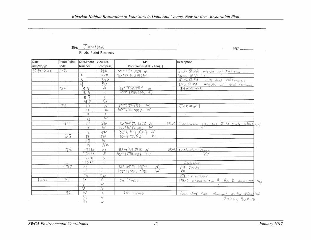
Riparian Habitat Restoration at Four Sites in Dona Ana County, New Mexico –Restoration Plan
SWCA Environmental Consultants 42 January 2017

Riparian Habitat Restoration at Four Sites in Dona Ana County, New Mexico –Restoration Plan
SWCA Environmental Consultants 43 January 2017
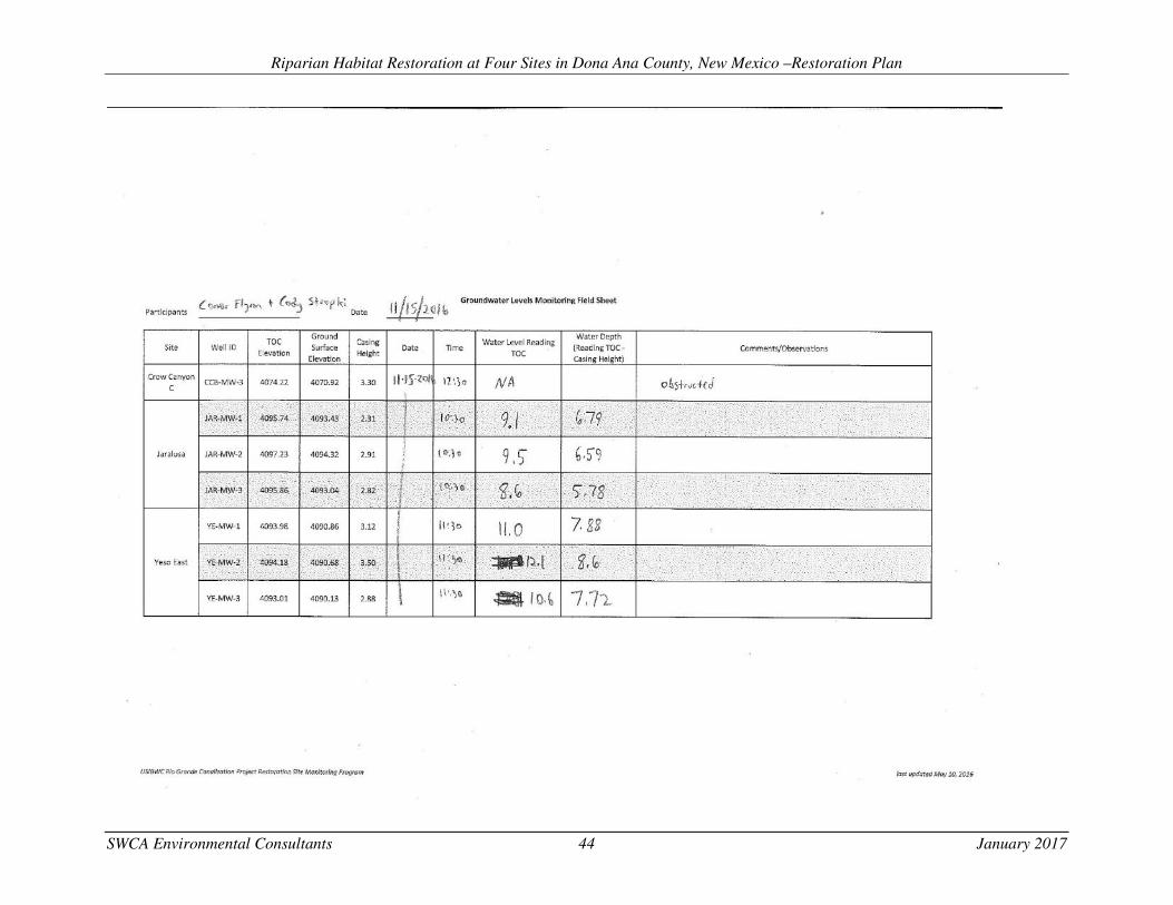
Riparian Habitat Restoration at Four Sites in Dona Ana County, New Mexico –Restoration Plan
SWCA Environmental Consultants 44 January 2017


![Restoring Salmonid Aquatic/Riparian Habitat...aquatic/riparian habitat restoration activities. [5] [6] VISION AND OBJECTIVES The overreaching goal of this initiative is to improve](https://static.fdocuments.in/doc/165x107/6104737c127ac45d1972c9a7/restoring-salmonid-aquaticriparian-habitat-aquaticriparian-habitat-restoration.jpg)