Riparian- Flood Plain Model Landscape Analysis Model Inputs SWAT Modifications REMM Additions ...
12
Riparian- Flood Plain Model Landscape Analysis Model Inputs SWAT Modifications REMM Additions Current Plans
-
Upload
june-kennedy -
Category
Documents
-
view
236 -
download
0
Transcript of Riparian- Flood Plain Model Landscape Analysis Model Inputs SWAT Modifications REMM Additions ...

Riparian- Flood Plain Model
Landscape Analysis Model Inputs SWAT Modifications
REMM AdditionsCurrent Plans

Landscape Analysis
Dr. Martin VolkCenter for Environmental Research
Leipzig, Germany

Study Area

The Saale River Basin (Central Germany) is subdivided inthree sub-regions: The Pleistocene lowlands, the loesssub-region and the mountainous sub-region. The lengthof river is about 320 km. Precipitation varies from 500 mm in the loess areas to 1200 mm in the forested mountain regions.
Delineation of the Landscape Units


Subbasin 18

HRU’s28% Range-Sandy51% Pasture – Silt16% Forest – Sandy4% - Agriculture - Silt
HRU’s28% Range-Sandy51% Pasture – Silt16% Forest – Sandy4% - Agriculture - Silt
HRU’s28% Range-Sandy51% Pasture – Silt16% Forest – Sandy4% - Agriculture - Silt

Subbasin 18 HRU 1
Forest
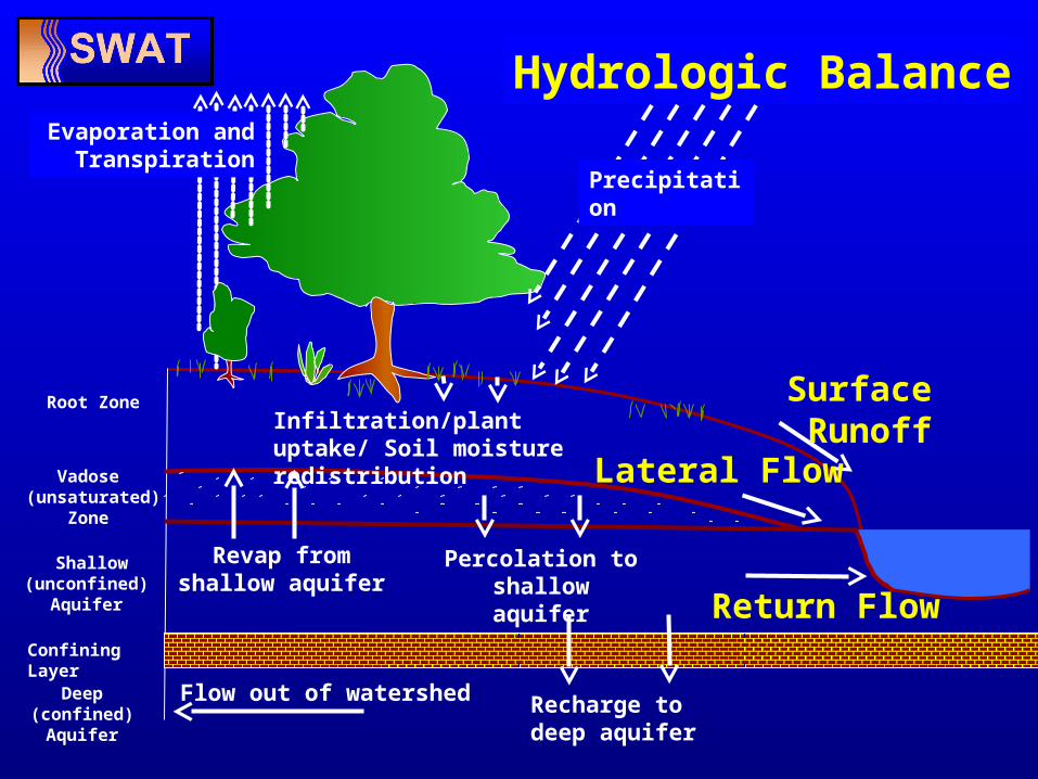
Root Zone
Shallow (unconfined)
Aquifer
Vadose (unsaturated)
Zone
Confining Layer
Deep (confined) Aquifer
Precipitation
Evaporation and Transpiration
Infiltration/plant uptake/ Soil moisture redistribution
Surface Runoff
Lateral Flow
Return Flow
Revap from shallow aquifer
Percolation to shallow aquifer
Recharge to deep aquifer
Flow out of watershed
Hydrologic Balance

• Landscape Positions (New HRUs: Valley floors, Hillslopes, Ridgetops)• Riparian Zones
FloodPlain Riparian Zone Flood
Plain
ShallowAquifer
Hillslope HRU’s
Bank Storage
Soil
Over BankFlood Plain
Ridgetop HRU’s
SWAT 2003 Current Research

Current Consortium• Riesel, Texas
Peter Allen – BaylorDaren Harmel
• Tifton, GeorgiaRichard LowranceDave Bosch
• University Park, PennsylvaniaBil GburekTammie Veith
• El Reno, OklahomaMike Van Liew