Rig Mobilisation for Major Drilling Program at Kouri Underway
15
Golden Rim Resources Ltd I ABN 39 006 710 774 I Level 2, 609 Canterbury Road, Surrey HillsVIC3127, Australia I PO Box 124, Surrey Hills VIC 3127, Australia www.goldenrim.com.au I [email protected] I T + 61 3 9836 4146 ASX/Media Announcement 26 March 2019 Rig Mobilisation for Major Drilling Program at Kouri Underway Highlights: Drilling Major contract executed for 17,000m of RC drilling and 4,000m of diamond drilling at Kouri. Mobilisation of a multi-purpose drilling rig from Mauritania to Burkina Faso (Kouri) has commenced. Drilling is expected to commence in mid-April 2019 and will initially target three areas: 1. Footwall Shear to follow-up recent high-grade drill intercepts including 4m at 44.7g/t gold (BARC327); 2. Strike extent of the gold lodes that comprise the 1.4Moz Mineral Resource into the Goueli and Margou permits 1 ; and 3. Red Hill gold discovery. Trenching 3.1km trenching program completed to assist with drill target identification along the Footwall Shear and at Red Hill. Assay results confirm multiple additional zones of gold mineralisation for follow-up drilling. Strongest zone of gold mineralisation obtained in the trenching is 13m at 1.6g/t gold located in a trench (NTR002) at Red Hill. Satellite Imagery Multiple gold lodes with artisanal workings that extend for more than 500m into the Goueli and Margou permits highlighted in new high-resolution satellite imagery and considered a priority drilling target. Emerging West African gold developer, Golden Rim Resources Ltd (ASX: GMR) (Golden Rim or Company), is pleased to provide an update on its exploration programs at its 100% owned Kouri Gold Project (Kouri) in Burkina Faso. Commenting on the upcoming drilling program at Kouri, Golden Rim’s Managing Director, Craig Mackay, said: “With the commencement of mobilisation of a multi-purpose drill rig to Kouri from Mauritania, we are now on the verge of what will be a very significant drilling program for the Company. 1 Acquisition of the Goueli and Margou permits subject to conditions, including shareholder approval (see ASX Announcement of 11 December 2018).
Transcript of Rig Mobilisation for Major Drilling Program at Kouri Underway

Golden Rim Resources Ltd I ABN 39 006 710 774 I Level 2, 609 Canterbury Road, Surrey HillsVIC3127, Australia I PO Box 124, Surrey Hills VIC 3127, Australia
www.goldenrim.com.au I [email protected] I T + 61 3 9836 4146
ASX/Media Announcement
26 March 2019
Rig Mobilisation for Major Drilling Program
at Kouri Underway Highlights:
Drilling
Major contract executed for 17,000m of RC drilling and 4,000m of diamond drilling at Kouri.
Mobilisation of a multi-purpose drilling rig from Mauritania to Burkina Faso (Kouri) has commenced.
Drilling is expected to commence in mid-April 2019 and will initially target three areas:
1. Footwall Shear to follow-up recent high-grade drill intercepts including 4m at 44.7g/t gold (BARC327);
2. Strike extent of the gold lodes that comprise the 1.4Moz Mineral Resource into the Goueli and Margou permits1; and
3. Red Hill gold discovery.
Trenching
3.1km trenching program completed to assist with drill target identification along the Footwall Shear and at Red Hill.
Assay results confirm multiple additional zones of gold mineralisation for follow-up drilling.
Strongest zone of gold mineralisation obtained in the trenching is 13m at 1.6g/t gold located in a trench (NTR002) at Red Hill.
Satellite Imagery
Multiple gold lodes with artisanal workings that extend for more than 500m into the Goueli and Margou permits highlighted in new high-resolution satellite imagery and considered a priority drilling target.
Emerging West African gold developer, Golden Rim Resources Ltd (ASX: GMR) (Golden Rim or Company), is pleased to provide an update on its exploration programs at its 100% owned Kouri Gold Project (Kouri) in Burkina Faso. Commenting on the upcoming drilling program at Kouri, Golden Rim’s Managing Director, Craig Mackay, said: “With the commencement of mobilisation of a multi-purpose drill rig to Kouri from Mauritania, we are now on the verge of what will be a very significant drilling program for the Company.
1 Acquisition of the Goueli and Margou permits subject to conditions, including shareholder approval (see ASX Announcement of 11
December 2018).
Page | 2
Trenching has allowed us to confirm the orientation of the gold mineralisation along the Footwall Shear and at Red Hill to ensure that we undertake the program in the most effective manner. In addition, newly obtained high-resolution satellite imagery indicates that we may have more than 500m of additional strike to the gold lodes that comprise the 1.4Moz Mineral Resource, into the Goueli and Margou permits. We intend to test these as a priority once we have completed the acquisition of the permits. We look forward to this very exciting drill program and will keep the market updated as we approach the expected mid-April 2019 drilling start-up.” Reverse Circulation and Diamond Drilling A drilling contract has been executed with Capital Drilling Limited (Capital Drilling) for a 17,000m Reverse Circulation (RC) drilling and 4,000m of diamond drilling program at Kouri. Capital Drilling participated in the Company’s recent share placement and are expected to become the Company’s largest shareholder, subject to shareholder approval of the second tranche under the placement. Capital Drilling is a company listed on the London Stock Exchange and has a focus on drilling in Africa. The company commenced operations in 2005 and has a fleet of 91 rigs, offering a range of services across exploration drilling, delineation drilling, underground, grade control and blast hole drilling, as well as ancillary services including minerals laboratory testing. The company has extensive operations across the African continent including Egypt, Botswana, Tanzania, Mali, Mauritania, Cote d’Ivoire, and Burkina Faso, employing 1,000 people in Africa. A multi-purpose drill rig is currently being mobilised from Mauritania to Kouri in Burkina Faso, with drilling expected to commence in mid-April 2019. The drilling will initially target three areas: 1. The Footwall Shear to follow-up the recent high-grade drill intersections of 4m at 44.7g/t gold, including 2m at
89.5g/t gold (BARC327) and 3m at 8.4g/t gold (BARC278), which lie 300m apart and are open along strike and at depth (Figure 1);
2. Strike extent of the gold lodes that comprise the 1.4Moz Mineral Resource into the Goueli and Margou permits, following completion of permit acquisition2 (Figure 4); and
3. Red Hill to follow-up recent intersections of 10m at 4.1g/t gold (NKRC054) and 11m at 3.4g/t gold (NKRC030) (Figure 3).
Footwall Shear Trench Results Multiple additional zones of gold mineralisation were outlined in the trenching along the Footwall Shear (Figure 2). These zones of mineralisation were located up to 1.6km west of the existing 1.4Moz gold Mineral Resource. One objective of the trenching was to determine the orientation of the gold mineralisation comprising a high-grade intercept of 4m at 44.7g/t gold (BARC327) in the Footwall Shear. While the alluvial cover above the intercept is too deep for trenching (>8m), trench BATR006 (located 500m east of BARC327) and trench BATR005 (located 700m west of BARC327) exposed steep north-dipping, east-west trending veining, that is parallel to the Footwall Shear.
2 Acquisition of the Goueli and Margou permits subject to conditions, including shareholder approval (see ASX Announcement of 11 December 2018)

Page | 3
In between, BATR005 and BARC327 a series of historical north-south trending trenches were located along the Footwall Shear and these trenches seem to have targeted a 500m long, east-west-trending, mineralised structure. These results indicate that the gold mineralisation comprising the intercept of 4m at 44.7g/t gold is also likely to be steep north dipping and east-west trending (parallel to, and hosted within the Footwall Shear). It is also thought the mineralisation is the same as that targeted in the historical trenching and this area will be the first area to be tested in the planned follow-up drilling program. Further to the west, the orientation of the Footwall Shear bends to the northwest. In this area, trench BATR004 exposed northeast-trending veining cutting across the Footwall Shear, including zones of 10m at 0.9g/t gold and 3m at 2.3g/t gold. These mineralised zones are associated with a prominent magnetic high anomaly believed to be related to a major shear structure that extends in a northeast orientation for more than 5km to Guitorga North, where previous auger drilling has returned results up to 2,360ppb gold (2.4g/t gold) (Figure 1). No drilling has been conducted along this shear to date. Red Hill Trench Results At Red Hill, the trenching confirmed that the gold mineralisation is north-dipping and east-northeast trending (Figure 3). Multiple zones of gold mineralisation were exposed in trench NTR002, including 13m at 1.6g/t gold and 2m at 1.6g/t gold. This mineralisation lies directly above previous drill intercepts of 16m at 1.8g/t gold and 10m at 2.2g/t gold (NKRC031) and 11m at 2.2g/t gold (NKRC030). Trench NTRC001 intersected 3m at 0.9g/t gold, 70m along strike to the east-northeast of previous drill intercepts of 11m at 3.4g/t gold (NKRC047) and 10m at 4.1g/t gold (NKRC054). Trench NTR006 lies 100m west of these drill intercepts and assays are pending.
Figure 1. Location of trenches along the Footwall Shear at Kouri

Page | 4
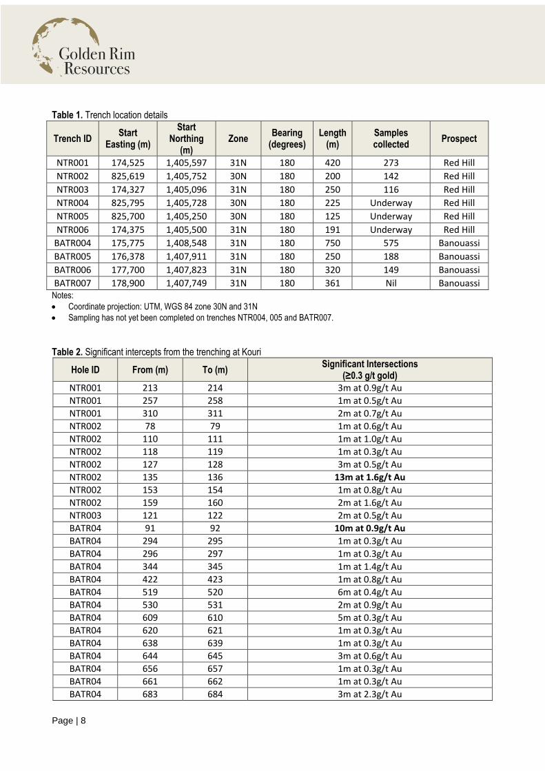
Details of the Trenching A total of ten trenches have been excavated at Kouri for a cumulative length of approximately 3,100m. Six trenches (NTR001 to NTR006) have been completed at Red Hill and four trenches (BATR004 to BATR007) were excavated along the Footwall Shear. Trench location details are provided in Table 1 and depicted in Figures 1, 2 and 3. Channel rock chip sampling was conducted on 1m intervals, horizontally, from north to south along the trenches to test areas where bedrock mineralisation was identified in trench mapping. The depth of the soil cover in the southern portion of BATR006 and all of BATR007 was too deep (>5m) for the excavator to reach bedrock. As such, no sampling was conducted in these areas. Assays for samples collected from trenches BATR004 – BATR006 and NTRC001 – NTRC003 have been received (total of 1,443 samples) and significant assay results are presented in Table 2. Given gold can be depleted in the oxide zone in Burkina Faso, lower grade gold results (0.2g/t – 0.3g/t gold) are considered important. Channel rock chip sampling of trenches NTR004 – NTR006 at Red Hill is underway and assay results are expected in the next few weeks. Satellite Imagery During January 2019 and February 2019, 325 km2 of DigitalGlobe WorldView-3 (0.3m resolution, 4-band) imagery was captured over the entire Kouri project area, including the Goulei and Margou permits that are being acquired from Lafi Gold Limited. GeoImage Pty Ltd processed the data. Multiple gold lodes with artisanal workings that extend from the eastern boundary of the current Mineral Resource for more than 500m into the Goueli and Margou permits have been further highlighted in the satellite imagery (Figure 4). These gold lodes will now be a priority drilling target following completion of the acquisition of the permits.
-ENDS-

Figure 2. Location of the trenches at Footwall Shear Red Hill (intercepts in blue boxes), in relation to drillholes, over a combination of satellite imagery and ground magnetics (analytical signal) data

Figure 3. Location of the trenches at Red Hill (intercepts in blue boxes), in relation to drillholes, over a combination of satellite imagery and ground magnetics (analytical signal) data

Figure 4. New high-resolution satellite imagery showing artisanal workings on the gold lodes that extend across the Kouri permit boundary (the current extent of the 1.4Moz gold Mineral Resource) and into the Goueli permit being acquired from Lafi Gold.
Page | 8
Table 1. Trench location details
Trench ID Start
Easting (m)
Start Northing
(m) Zone
Bearing (degrees)
Length (m)
Samples collected
Prospect
NTR001 174,525 1,405,597 31N 180 420 273 Red Hill
NTR002 825,619 1,405,752 30N 180 200 142 Red Hill
NTR003 174,327 1,405,096 31N 180 250 116 Red Hill
NTR004 825,795 1,405,728 30N 180 225 Underway Red Hill
NTR005 825,700 1,405,250 30N 180 125 Underway Red Hill
NTR006 174,375 1,405,500 31N 180 191 Underway Red Hill
BATR004 175,775 1,408,548 31N 180 750 575 Banouassi
BATR005 176,378 1,407,911 31N 180 250 188 Banouassi
BATR006 177,700 1,407,823 31N 180 320 149 Banouassi
BATR007 178,900 1,407,749 31N 180 361 Nil Banouassi Notes:
Coordinate projection: UTM, WGS 84 zone 30N and 31N
Sampling has not yet been completed on trenches NTR004, 005 and BATR007.
Table 2. Significant intercepts from the trenching at Kouri
Hole ID From (m) To (m) Significant Intersections
(≥0.3 g/t gold)
NTR001 213 214 3m at 0.9g/t Au
NTR001 257 258 1m at 0.5g/t Au
NTR001 310 311 2m at 0.7g/t Au
NTR002 78 79 1m at 0.6g/t Au
NTR002 110 111 1m at 1.0g/t Au
NTR002 118 119 1m at 0.3g/t Au
NTR002 127 128 3m at 0.5g/t Au
NTR002 135 136 13m at 1.6g/t Au
NTR002 153 154 1m at 0.8g/t Au
NTR002 159 160 2m at 1.6g/t Au
NTR003 121 122 2m at 0.5g/t Au
BATR04 91 92 10m at 0.9g/t Au
BATR04 294 295 1m at 0.3g/t Au
BATR04 296 297 1m at 0.3g/t Au
BATR04 344 345 1m at 1.4g/t Au
BATR04 422 423 1m at 0.8g/t Au
BATR04 519 520 6m at 0.4g/t Au
BATR04 530 531 2m at 0.9g/t Au
BATR04 609 610 5m at 0.3g/t Au
BATR04 620 621 1m at 0.3g/t Au
BATR04 638 639 1m at 0.3g/t Au
BATR04 644 645 3m at 0.6g/t Au
BATR04 656 657 1m at 0.3g/t Au
BATR04 661 662 1m at 0.3g/t Au
BATR04 683 684 3m at 2.3g/t Au

Page | 9
Hole ID From (m) To (m) Significant Intersections
(≥0.3 g/t gold)
BATR05 157 158 1m at 0.4g/t Au
BATR05 202 203 1m at 0.3g/t Au
BATR05 225 226 2m at 0.4g/t Au
BATR06 9 10 1m at 0.7g/t Au
BATR06 75 76 1m at 0.3g/t Au
BATR06 138 139 1m at 0.5g/t Au
BATR06 178 180 2m at 0.6g/t Au
BATR06 184 185 1m at 0.5g/t Au Notes:
All reported intersections are assayed at 1m intervals.
Intercept cut-off grade is 0.3 g/t gold.
Intervals are reported with a maximum of 4m of internal dilution unless the total intercept grade falls below 0.3 g/t gold.
Intercept intervals (From and To) are the horizontal distances from the trench start (origin) detailed in Table 1.
Sample preparation and assaying conducted by BIGS Laboratory in Ouagadougou.
Assayed by 50g charge fire assay with Atomic Absorption Spectrometry (AAS) finish.

Page | 10
Appendix 1: JORC Code (2012 Edition), Assessment and Reporting Criteria
Section 1: Sampling Techniques and Data
Criteria JORC Code Explanation Explanation
Sampling Techniques
Nature and quality of sampling (e.g. cut channels, random chips, or specific specialised industry standard measurement tools appropriate to the minerals under investigation, such as down hole gamma sondes, or handheld XRF instruments, etc.). These examples should not be taken as limiting the broad meaning of sampling.
The sampling described in this report refers to channel sampling of trenches.
The trenches were prepared with an excavator to an average depth of 4m to expose weathered bedrock beneath transported cover.
The channel samples were taken across the face of the trench (below the transported soil cover) in 1 metre intervals.
Samples were all collected by qualified geologists or under geological supervision.
The samples are judged to be representative of the rock being drilled.
The nature and quality of sampling is carried out under QAQC procedures as per industry standards.
Include reference to measures taken to ensure sample representivity and the appropriate calibration of any measurement tools or systems used.
Sampling is guided by Golden Rim’s protocols and Quality Control procedures as per industry standards.
Aspects of the determination of mineralisation that are Material to the Public Report.
In cases where ‘industry standard’ work has been done this would be relatively simple (e.g. ‘reverse circulation drilling was used to obtain 1 m samples from which 3 kg was pulverised to produce a 30g charge for fire assay’). In other cases, more explanation may be required, such as where there is coarse gold that has inherent sampling problems. Unusual commodities or mineralisation types (e.g. submarine nodules) may warrant disclosure of detailed information.
Samples were submitted to BIGS Laboratory in Ouagadougou for preparation and analysis.
Trench samples are crushed through a RDS Boyd crusher to -2mm and pulverised via LM2 to a nominal 90% passing -75μm.
A 200g sub-sample is taken for analysis. A 50g charge weight is fused with litharge-based flux, cupelled and the prill dissolved in aqua regia and gold tenor is determined by AAS.
Drilling Techniques
Drill type (e.g. core, reverse circulation, open-hole hammer, rotary air blast, auger, Bangka, sonic, etc.) and details (e.g. core diameter, triple or standard tube, depth of diamond tails, face-sampling bit or other type, whether core is oriented and if so, by what method, etc.).
Not applicable.
Drill sample recovery
Method of recording and assessing core and chip sample recoveries and results assessed.
Sample recovery is not assessed for trench sampling as it is a geochemical method.
Measures taken to maximise sample recovery and ensure representative nature of the samples.
Trench samples are visually checked by a technician for geology, moisture and contamination.
Whether a relationship exists between sample recovery and grade and whether sample bias may have occurred due to preferential loss/gain
No relationship is seen to exist between sample recovery and grade.

Page | 11
Criteria JORC Code Explanation Explanation
of fine/coarse material. No sample bias has occurred.
Logging Whether core and chip samples have been geologically and geotechnically logged to a level of detail to support appropriate Mineral Resource estimation, mining studies and metallurgical studies.
Trench samples are not used for Mineral Resource estimation.
Each sample interval was geologically logged in a qualitative fashion.
The geological logging was done using a standardised logging system. This information and the sampling details were transferred into Golden Rim’s drilling database.
Whether logging is qualitative or quantitative in nature. Core (or costean, channel, etc) photography.
Logging is both qualitative and quantitative, depending on the field being logged.
The total length and percentage of the relevant intersections logged.
100% of each relevant intersection is logged in detail.
Sub-sampling techniques and sample preparation
If core, whether cut or sawn and whether quarter, half or all core taken.
No drill core sampling was reported in this announcement
If non-core, whether riffled, tube sampled, rotary split, etc and whether sampled wet or dry.
The entire trench sample was submitted for assay, so no sub-sampling is required. Samples were dry.
For all sample types, the nature, quality and appropriateness of the sample preparation technique.
Samples were transported by road to BIGS Laboratory in Ouagadougou.
The sample preparation for all samples follows industry best practice.
At the laboratory, all samples were weighed, dried and crushed to -2mm in a jaw crusher. A split of the crushed sample was subsequently pulverised in a ping mill to achieve a nominal particle size of 90% passing 75μm.
Quality control procedures adopted for all sub-sampling stages to maximise representivity of samples.
Golden Rim has protocols that cover the sample preparation at the laboratories and the collection and assessment of data to ensure that accurate steps are used in producing representative samples.
The crusher and pulveriser are flushed with barren material at the start of every batch.
Measures taken to ensure that the sampling is representative of the in-situ material collected, including for instance results for field duplicate/second-half sampling.
Sampling is carried out in accordance with Golden Rim’s protocols as per industry best practice.
Field QC procedures involve the use of certified reference material as assay standards and duplicates for the trench samples.
Whether sample sizes are appropriate to the grain size of the material being sampled.
The sample sizes of approximately 3kg are considered appropriate to correctly represent the style of mineralisation, the thickness and consistency of the intersections.
Quality of assay data and laboratory tests
The nature, quality and appropriateness of the assaying and laboratory procedures used and whether the technique is considered partial or total.
A 200g sub-sample is taken for analysis. A 50g charge weight is fused with litharge-based flux, cupelled and the prill dissolved in aqua regia and gold tenor is determined by AAS. The analytical method is considered appropriate for this mineralisation style and is of industry standard.
The quality of the assaying and laboratory procedures are

Page | 12
Criteria JORC Code Explanation Explanation
considered to be appropriate for this deposit type.
For geophysical tools, spectrometers, handheld XRF instruments, etc., the parameters used in determining the analysis including instrument make and model, reading times, calibrations factors applied and their derivation, etc.
No geophysical tools were used to determine any element concentrations.
Nature of quality control procedures adopted (e.g. standards, blanks, duplicates, external laboratory checks) and whether acceptable levels of accuracy (i.e. lack of bias) and precision have been established.
Sample preparation checks for fineness were carried out by the laboratory as part of their internal procedures to ensure the grind size of 90% passing 75 microns.
Verification of sampling and assaying
The verification of significant intersections by either independent or alternative company personnel.
Reported results are compiled and verified by the Company’s Senior Geologist and the Managing Director.
The use of twinned holes. No drill holes are reported in this report.
Documentation of primary data, data entry procedures, data verification, data storage (physical and electronic) protocols.
Primary field data is collected by Golden Rim geologists on standardised logging sheets. This data is compiled and digitally captured.
The compiled digital data is verified and validated by the Company’s database geologist.
Discuss any adjustment to assay data. The primary data is kept on file. There were no adjustments to the assay data.
Location of data points
Accuracy and quality of surveys used to locate drill holes (collar and down-hole surveys), trenches, mine workings and other locations used in Mineral Resource estimation.
Start and end positions of the trenches were recorded by hand held GPS with a positional accuracy of approximately +/- 5 metres.
Specification of the grid system used. Location data was collected in UTM grid WGS84, zones 30 and 31 North
Quality and adequacy of topographic control. Hand held GPS was used for topographic control
Data spacing and distribution
Data spacing for reporting of Exploration Results. Trenches were excavated at right-angles (180 degrees) to the main trend of the mineralisation
Whether the data spacing and distribution is sufficient to establish the degree of geological and grade continuity appropriate for the Mineral Resource and Ore Reserve estimation procedure(s) and classifications applied.
Trench sampling is not appropriate for the calculation of any Mineral Resource estimate.
Whether sample compositing has been applied. There was no sample composting.
Orientation of data in relation to geological structure
Whether the orientation of sampling achieves unbiased sampling of possible structures and the extent to which this is known, considering the deposit type.
Trenches are excavated vertically, along 180 degree orientated grid lines. The strike of mineralisation in the Kouri licence is approximately 050 degrees.
If the relationship between the drilling orientation and the orientation of key mineralised structures is considered to have introduced a sampling bias, this should be assessed and reported if material.
No orientation-based sampling bias has been identified in the data at this point.

Page | 13
Criteria JORC Code Explanation Explanation
Sample security
The measures taken to ensure sample security. Samples are stored on site prior to road transport by Company personnel to the laboratory in Ouagadougou, Burkina Faso.
Audits or reviews
The results of any audits or reviews of sampling techniques and data.
There has been no external audit or review of the Company’s techniques or data.
Section 2: Reporting of Exploration Results
Criteria JORC Code explanation Explanation
Mineral tenement and land tenure status
Type, reference name/number, location and ownership including agreements or material issues with third parties such as joint ventures, partnerships, overriding royalties, native title interests, historical sites, wilderness or national park and environmental settings.
The trench sampling results are from the Kouri permit.
Golden Rim owns 100% of the permit.
The security of the tenure held at the time of reporting along with any known impediments to obtaining a licence to operate in the area.
Tenure is in good standing.
Exploration done by other parties
Acknowledgment and appraisal of exploration by other parties.
The area that is presently covered by the Kouri permit has undergone some previous mineral exploration.
Geology Deposit type, geological setting and style of mineralisation.
The Kouri Project covers part of a highly prospective Lower Proterozoic Birimian, Samira Hill Greenstone belt and is traversed by a significant NE-trending fault splay which is connected to the major Markoye Fault system. This fault system controls several major gold deposits in Burkina Faso, including Kiaka (5.9 Moz), Bomboré (5.2 Moz) and Essakan (7 Moz).
The mineralisation lies in a package of highly altered volcanic and volcaniclastic host rocks and is associated with a major gold-in-soil anomaly and a prominent dilational structural jog along a regional NE-trending shear zone.
Drill hole Information
A summary of all information material to the understanding of the exploration results including a tabulation of the following information for all Material drill holes:
easting and northing of the drill hole collar elevation or RL (Reduced Level – elevation above sea level in metres) of the drill hole collar
dip and azimuth of the hole
down hole length and interception depth
hole length.
Trench sampling is a reconnaissance exploration technique.
Typically each metre of in-situ material (below soil cover) is face sampled.
Appropriate locality maps for the trenches accompanies this announcement.
If the exclusion of this information is justified on the basis that the information is not Material and this exclusion does not detract from the understanding of the report, the Competent Person should clearly explain why this is the case.
Drill hole intersections are not reported in this announcement.
Data aggregation methods
In reporting Exploration Results, weighting averaging techniques, maximum and/or minimum grade truncations (eg cutting of high grades) and cut-off
No weighting or high grade cutting techniques have been applied to the data reported.
Assay results are generally quoted rounded to 1 decimal

Page | 14
Criteria JORC Code explanation Explanation
grades are usually Material and should be stated. place.
Where aggregate intercepts incorporate short lengths of high grade results and longer lengths of low grade results, the procedure used for such aggregation should be stated and some typical examples of such aggregations should be shown in detail.
Not applicable in this document as no exploration results are announced.
The assumptions used for any reporting of metal equivalent values should be clearly stated.
Metal equivalent values are not reported in this announcement.
Relationship between mineralisation widths and intercept lengths
These relationships are particularly important in the reporting of Exploration Results.
The reported trench results are from early stage reconnaissance exploration.
If the geometry of the mineralisation with respect to the drill hole angle is known, its nature should be reported.
Not applicable in this document as no drilling results are announced.
If it is not known and only the down hole lengths are reported, there should be a clear statement to this effect (e.g. ‘down hole length, true width not known’).
Not applicable in this document as no drilling results are announced.
Diagrams Appropriate maps and sections (with scales) and tabulations of intercepts should be included for any significant discovery being reported These should include, but not be limited to a plan view of drill hole collar locations and appropriate sectional views.
Appropriate location maps and sections are provided in the main text.
Balanced reporting
Where comprehensive reporting of all Exploration Results is not practicable, representative reporting of both low and high grades and/or widths should be practiced to avoid misleading reporting of Exploration Results.
The accompanying document is considered to represent a balanced report.
Other substantive exploration data
Other exploration data, if meaningful and material, should be reported including (but not limited to): geological observations; geophysical survey results; geochemical survey results; bulk samples – size and method of treatment; metallurgical test results; bulk density, groundwater, geotechnical and rock characteristics; potential deleterious or contaminating substances.
There is no other exploration data which is considered material to the results reported in the announcement.
Further work The nature and scale of planned further work (eg tests for lateral extensions or depth extensions or large-scale step-out drilling).
Promising results will be followed up (where practicable) with RC or DD drilling.
Exploration and infill drilling will continue to target projected lateral and depth extensions of the mineralisation and to increase the confidence in the Mineral Resource.
Diagrams clearly highlighting the areas of possible extensions, including the main geological interpretations and future drilling areas, provided this information is not commercially sensitive.
Refer to main body of this report.

Page | 15
Competent Persons Statements The information in this report that relates to exploration results is based on information compiled by Mr Craig Mackay, a Competent Person who is a member of The Australasian Institute of Mining and Metallurgy. Mr Mackay is a full-time employee of Golden Rim Resources Ltd. Mr Mackay has sufficient experience that is relevant to the style of mineralisation and type of deposit under consideration and to the activity being undertaken to qualify as a Competent Person as defined in the 2012 Edition of the Australasian Code for Reporting of Exploration Results, Mineral Resources and Ore Reserves. Mr Mackay consents to the inclusion in the report of the matters based on his information in the form and context in which it appears. The information in this report relating to previous exploration results are extracted from the announcements: Bonanza Intercept of 4m at 44.7g/t Gold at Kouri dated 16 January 2019; 10m at 4.1g/t Gold Intersected at Red dated 15 January 2019; New Gold Intercepts at Red Hill Indicate Potential of Sizable New Gold Discovery dated 14 December 2018; Strategic Acquisition to Secure Strike Extent to the 1.4Moz Gold Kouri Mineral Resource dated 11 December 2018; 1.4 Million Oz of Gold in Upgraded Kouri Mineral Resource dated 3 December 2018, New Gold Discovery at Red Hill dated 16 July 2018; and has been reported in accordance with the 2012 edition of the JORC Code. These announcements are available on the Company’s website (www.goldenrim.com.au). The Company confirms that it is not aware of any new information or data that materially affects the information included in these announcements. Forward Looking Statements Certain statements in this document are or maybe “forward-looking statements” and represent Golden Rim’s intentions, projections, expectations or beliefs concerning among other things, future exploration activities. The projections, estimates and beliefs contained in such forward looking statements necessarily involve known and unknown risks, uncertainties and other factors, many of which are beyond the control of Golden Rim, and which may cause Golden Rim’s actual performance in future periods to differ materially from any express or implied estimates or projections. Nothing in this document is a promise or representation as to the future. Statements or assumptions in this document as to future matters may prove to be incorrect and differences may be material. Golden Rim does not make any representation or warranty as to the accuracy of such statements or assumptions.
For Further Information Please Contact: Golden Rim Resources Media and Broker Enquiries Craig Mackay Andrew Rowell Managing Director Director – Investor Relations Golden Rim Resources Cannings Purple +61 3 9836 4146 +61 400 466 226 [email protected] [email protected]
About Golden Rim Resources Emerging West African gold developer, Golden Rim Resources Limited (ASX: GMR), is focused on the discovery and development of gold projects in West Africa.
With a decade of experience working in Burkina Faso, the Company is well placed to turn discoveries into real value for shareholders.
The Kouri Gold Project, located in north-east Burkina Faso, contains over 1.4Moz in defined Mineral Resources, with significant upside potential to grow.
Kouri is traversed by a significant NE-trending fault splay that is connected to the major Markoye Fault system. This fault system controls a number of major gold deposits in Burkina Faso, including Kiaka (5.9 Moz gold), Bomboré (5.2 Moz gold), Essakane (7 Moz gold) and Sanbrado (2.8 Moz gold). The mineralised fault system extends into western Niger where the 2.5 Moz Samira Hill is located.
For more information: www.goldenrim.com.au ASX Code: GMR Market Capitalisation: A$8m Issued Shares: 587.9m Cash (as at 31 December 2018): A$1.3m