Richard A. Friedman,
27
229 13 LiDAR and 3-D Digital Modeling Reveal the Greater Chaco Landscape Richard A. Friedman, Anna Sofaer, and Robert S. Weiner DOI: 10.5876/9781646421701.c013 Watch the video version of this chapter, recorded at Crow Canyon Archaeological Center in August 2017. https://doi.org/10.5876/9781646421701.c013.v000 INTRODUCTION Across the vast desert region of the Four Corners, monumental sites of the Chaco culture and their asso- ciated linear “roads” are vanishing through the effects of erosion, deposition, and human activities. Often, even better-preserved features are so subtle that they are detectable only to the trained eye. e technolo- gies of Light Detection and Ranging (LiDAR) and Structure from Motion Photogrammetry (SfM) introduced in this chapter provide an opportunity to appreciate the original grandeur and enormous geo- graphic expanse of the 150-to-200 Chacoan Great House complexes of massed architecture, earthworks, and roads: their impressive scale, geometric rigor, and uniformity of style. e creation of highly resolved three-dimensional (3D) models of these great complexes set in their distinctive, culturally modified landscapes can aid researchers in understanding and interpreting (1) the interrelationships between architectural sites, and (2) the significance of interrelationships of natural features and associated architectural/architectonic structures. Questions that these types of landscape- scale datasets may help answer include the Chacoans’
Transcript of Richard A. Friedman,

229
13
LiDAR and 3- D Digital Modeling Reveal the Greater Chaco Landscape
Richard A. Friedman, Anna Sofaer, and Robert S. Weiner
DOI: 10.5876/9781646421701.c013
Watch the video version of this chapter, recorded at Crow Canyon Archaeological Center in August 2017.
https:// doi .org/ 10 .5876/ 9781646421701 .c013 .v000
INTRODUCTIONAcross the vast desert region of the Four Corners,
monumental sites of the Chaco culture and their asso-ciated linear “roads” are vanishing through the effects of erosion, deposition, and human activities. Often, even better- preserved features are so subtle that they are detectable only to the trained eye. The technolo-gies of Light Detection and Ranging (LiDAR) and Structure from Motion Photogrammetry (SfM) introduced in this chapter provide an opportunity to appreciate the original grandeur and enormous geo-graphic expanse of the 150- to- 200 Chacoan Great House complexes of massed architecture, earthworks, and roads: their impressive scale, geometric rigor, and uniformity of style.
The creation of highly resolved three- dimensional (3D) models of these great complexes set in their distinctive, culturally modified landscapes can aid researchers in understanding and interpreting (1) the interrelationships between architectural sites, and (2) the significance of interrelationships of natural features and associated architectural/architectonic structures. Questions that these types of landscape- scale datasets may help answer include the Chacoans’

230 RICHARD A. FRIEDMAN, ANNA SOFAER, AND ROBERT S. WEINER
choices for site location, the interrelationship of public architecture (Great Houses, Great Kivas, etc.) across time and space, design evolution of public architecture and architectonic features over time, and their possible align-ments to celestial cycles. Roads in particular can be studied for their intri-cate relationships to buildings, earthworks, and landscape features, as well as for their role in connecting sites through time. Insights into what was uni-form and synchronous in outlier Great Houses and what traits were similar or not to the buildings of Chaco Canyon will shed light on the extent and nature of power and influence held by the great architectural complex in Chaco Canyon.
In this chapter, we demonstrate our use of two recent technologies— LiDAR for large- scale, landscape- scale analysis, and SfM Photogrammetry for more refined, smaller- scale analysis— showing highly effective results in precisely documenting and studying Chaco sites and landscapes. What in the past entailed manual mapping at remote sites with a high cost can now be accomplished with far less investment and greater accuracy and, most significant, can encompass the site’s important relationships within their larger landscapes. Although use of the new technologies requires follow- up ground truthing at each site, the person hours for such survey work is mini-mal compared to the time involved in the use of earlier survey techniques. Features located outside protected Great House boundaries that have often not been documented in earlier surveys, such as roads and their associated shrines and earthworks, can now be efficiently recorded and therefore be afforded better protection.
Three- dimensional models created by these technologies will allow both researchers and the public to appreciate the spatial extent, time depth, and nearly incomprehensible monumentality of the Chacoans’ built environ-ment. Chaco sites are rarely visualized in three dimensions, and yet 3D digi-tal models can now provide an experiential sense of the monumentality of Great Houses and “roads” that one seldom gets when visiting the site in per-son. Ultimately, these technologies can provide a comprehensive overview of the Chaco World in its impressive geographic expanse and time depth. The more that policy makers, researchers, and the public can experience the scale and refined nature of the Chacoans’ investment in their harshly challenging environment, encompassing a region of up to 100,000 sq km, and the degree of conceptual planning required to achieve it, the greater the chance for rec-ognition and support— as well as knowledgeable guidance and policies— for protecting their extraordinary legacy.

LIDAR AND 3- D DIGITAL MODELING REVEAL THE GREATER CHACO LANDSCAPE 231
BACKGROUND ON CHACO LANDSCAPES AND ROADSGreat Houses, Outliers, and Landscapes
Previous research has contributed critical insights into the nature of Chaco landscapes and the Chacoans’ immense investment in their layered, multi-component constructions. The eleven monumental Great Houses within Chaco Canyon are examples of some of the most captivating architecture in the ancient Americas. The extravagance of Pueblo Bonito is especially strik-ing. It stood four stories tall with over 700 rooms and 36 kivas and contained vast quantities of precious objects: tens of thousands of pieces of turquoise, conch shell trumpets, wooden staffs, macaws, cylinder vessels with cacao resi-dues, copper bells, gambling implements, and finely crafted, hachured pottery ( Judd 1954; Pepper 1920). The labor and management required to construct Chaco Canyon’s Great Houses is impressive, requiring the transport by foot of 240,000 timbers from distant mountains, located 70– 90 km from the canyon (Guiterman et al. 2016).
Pioneering surveys in the 1970s and ’80s documented approximately sev-enty Chacoan Great House communities across the 20,000- sq- km San Juan Basin, revealing a larger geographic cultural influence of Chaco Canyon than had previously been understood. These surveys showed the replicated styles of these structures to be similar to Great Houses in the central canyon, with ceremonial kivas blocked into monumental multistoried constructions (Lekson, chapter 2 in this volume; Marshall et al. 1979; Marshall and Sofaer 1988; Powers et al. 1983). Later studies showed a still broader expanse of repeat-edly replicated Chacoan architecture at 150– 200 Great House sites up to 250 km from the canyon (Cameron 2009; Fowler and Stein 1992; Kantner and Mahoney 2000; Stein and Lekson 1992). In the words of Stephen Lekson,
“The explosive expansion of outliers outdistanced our abilities to render them believable” (2015:19– 20).
Clearly, such uniform expression of architecture across 100,000 sq km required a powerful and compelling conceptual framework to unite diverse populations. John Stein and Lekson (1992) called this bonding ideology the
“Big Idea,” which they saw as expressed in the canonical layout of a Chaco out-lier community: a Great House ringed by large earthworks, with 9- m- wide lin-ear roadlike features (described in depth below) emanating from breaks in the mounds (earthworks) in a spokelike configuration. These Chacoan complexes, they noted, “are . . . inextricably tied, physically and cognitively, to a broader sacred geography that embraces the natural landscape” (Stein and Lekson 1992:87). This research was fundamental in establishing that a shared belief system underlay the organization of Chacoan landscapes and architecture.

232 RICHARD A. FRIEDMAN, ANNA SOFAER, AND ROBERT S. WEINER
The Solstice Project has reached a similar conclusion regarding the primary role of Chacoan buildings less as functional structures but rather as sym-bolic expressions of cosmology. Four decades of research have revealed that Chacoan rock art (Sofaer et al. 1979; Sofaer et al. 1982; Sofaer and Sinclair 1983), Great House architecture (Sofaer 2007), roads (Sofaer et al. 1989), and shrines (Sofaer et al. 2017) commemorated solar and lunar astronomy through light and shadow markings, wall alignments, internal geometries, and inter-site alignments.
The principle of uniting the sun and moon is evident in the Chacoans’ astro-nomical commemorations at multiple levels and scales. At the Sun Dagger site, for example, sunlight channeled through the slabs from above produces a set of “light daggers” that mark the summer and winter solstices on a large spiral petroglyph (Sofaer et al. 1979). The lunar standstill cycle is also marked by shadows cast onto this same spiral petroglyph by the rising moon (Sofaer et al. 1982). Similarly, Pueblo Bonito and Chetro Ketl, the two largest Great Houses in Chaco, are solar and lunar aligned, respectively, and located east- west of each another as part of a cardinal cross that forms the central axis of
“downtown Chaco” (Sofaer 2007). An astronomy that united the sun and moon in powerful displays at the center of the Chaco culture must have helped to enable its expanse across the Colorado Plateau.
While developing monumental constructions in a surprisingly challenging environment, the Chaco people apparently endowed this rugged landscape with special powers, in some cases interconnected with astronomy. Earlier studies show that the Chacoans were cognizant of dramatic viewsheds and relationships to prominent landforms in the placement of Great Houses (Van Dyke 2007). Studies of Chaco roads have shown that many were built as connections with distinctive landscape features of buttes, pinnacles, canyons, and springs, including the Great North Road as an alignment joining the direction north with the topographic feature of Kutz Canyon (Marshall 1997; Sofaer et al. 1989). Similarly, the Chimney Rock Great House was located on a sharp precipice to view, once every eighteen to nineteen years, the rise of the northern major lunar standstill moon between two large rock pillars (Malville 2004). Most recently, analysis of the locations of twelve shrines on high posi-tions of the three mesas that form the south side of Chaco Canyon show that they were located on numerous intersite alignments to the major standstill moon (Sofaer et al. 2017). This finding in turn reveals that the canyon itself is aligned to the moon, suggesting that such a topographic relationship of the central canyon may have inspired in part the Chacoans’ extensive commemo-rations of the sun with the moon.

LIDAR AND 3- D DIGITAL MODELING REVEAL THE GREATER CHACO LANDSCAPE 233
The sharply sculpted landscape of Chaco Canyon itself, and its surrounding distinctive landforms that emerge or drop down from the flat desert terrain, may have provided special assets for landscape planning on a cosmic scale. Powerful attractions could have been the canyon’s apparent lunar alignment, its location at the approximate center of the San Juan Basin, and the dis-tinctive form at its entrance of Fajada Butte’s towering mass, site of the Sun Dagger, as well as the distant northern and southern features of, respectively, Hosta Butte and Kutz Canyon. These distinctive land formations may have provided an inspiring setting for the Chacoans’ vastly conceived cosmographic road connections and buildings alignments.
Pueblo and Navajo people perceive Chaco as a living, breathing entity with great relevance in the present (e.g., Tsosie, chapter 8 and chapter 7 in this vol-ume; Vallo, chapter 7 in this volume). While these histories and information are only shared under certain circumstances, at particular times of year, and within an appropriate context, they reveal the deep knowledge of Chacoan landscapes held within Native traditions. In some cases, archaeological find-ings suggest resonances with the cultural traditions of descendant peoples (e.g., Sofaer 1999; Stein et al. 2007; Weiner 2018).
Chaco RoadsChaco roads are linear surface anomalies, generally 9 m wide, marked by
excavated roadbed cleared of rocks and vegetation and occasionally paved with caliche, adobe, or stone. Masonry walls, low stone curbs, cairns, or earthen mounds/berms sometimes define road edges, and elongated linear ceramic scatters consisting of distinct, scattered vessels (rather than single pot drops) are often present along roadbeds (Nials 1983:6. 21–6. 23). Crescent- shaped masonry herraduras, earthen mounds and berms, and ritual architecture also commonly accompany these linear features (Nials et al. 1987:6.8–6. 18).
Numerous pieces of evidence suggest that the word road may be a mislead-ing descriptor for these monumental linear features. First, their 9 m width far exceeds any utilitarian necessity, especially considering the lack of pack animals or wheeled vehicles among the Chaco culture. Second, these features main-tain their linearity across topographic obstacles, a finding that conflicts with the notion of trade conduits. Third, only a few roads have been definitively shown to exist as long continuous features (e.g., the North and South Roads), and most are short segments either connecting Great Houses and Great Kivas or emanating as short (i.e., less than 1 km) “spokes” from a Great House (Roney 1992). Other examples exist as enigmatic circles or loops, such as at the Holmes

234 RICHARD A. FRIEDMAN, ANNA SOFAER, AND ROBERT S. WEINER
Group. The possibility of further length to these segments should, however, be evaluated with new technologies. Finally, Bureau of Land Management (BLM) researchers involved in the last large- scale roads study concluded: “There is no evidence . . . roads encouraged either construction of individual residences or establishment of settlements along the road alignment. There is no evidence that purely domiciliary sites articulate with the roads” (Nials et al. 1987:25).
We also wish to redress the misconception that “roads” are associated solely with the so- called Chaco Phenomenon of the eleventh century ad. Roads have been recognized at sites from ad 600 to ad 1250, spanning the Basketmaker III through Pueblo III periods. For example, roads articulate with architec-tural features at Two Grey Hills, a Basketmaker III site that yielded AMS radiocarbon dates between ad 600 and ad 650 (Ruppe’ et al. 2001; figure 13.1). Other roads have been documented from the thirteenth– fourteenth centuries (Fowler and Stein 1992).
It is of particular interest that certain roads connect sites separated by gen-erations and even centuries, appearing to mark ancestral relationships between sites. Fowler and Stein (1992) called these roads “time bridges.” This phenom-enon is present at sites associated with Manuelito Canyon, the South Road, Padilla Wash (figure 13.2), Red Willow, Taylor Springs, and numerous other Great House complexes.
Other roads appear to have been built to express relationships with the distinctively sculpted landforms of the Chaco region. The 55 km South Road
Figure 13.1. Map showing prehistoric roads documented at Two Grey Hills, a Basketmaker III site. Modified by Richard Friedman after Ruppe’ et al. (2001:fig. 1).

LIDAR AND 3- D DIGITAL MODELING REVEAL THE GREATER CHACO LANDSCAPE 235
articulates with the towering Hosta Butte, and the 10 km Ah- shi- sle- pah Road leads to Black Lake, an ephemeral pond (Sofaer et al. 1989). Some short road segments emanating from Great Houses in a “spoke” pattern appear to mark alignments to distinctive landscape features including lakes, caves, springs, pinnacles, and buttes (Marshall 1997). Other roads appear to mark astronomi-cal alignments, such as one at the Skunk Springs Great House that is oriented to the winter solstice sunrise (for another possibility, see Tuwaletstiwa and Marshall, chapter 4 in this volume).
Chaco’s 50.5 km Great North Road is perhaps the most compelling illustra-tion of the Chacoans’ regard for landforms and their inherent power, especially when joined with astronomical direction. Anna Sofaer et al. (1989) suggest its purpose was to materialize an alignment to the direction North from Chaco Canyon while also commemorating the striking badlands topography of Kutz Canyon in a “cosmographic expression.” Numerous scaffolds and rampways ascend the cliffs behind the central canyon great houses and join at Pueblo Alto. From Pueblo Alto, these routes converge and travel north within a quarter of a degree of accuracy across one of the least- inhabited sectors of the Chaco region.
The absence of population centers, camping sites, resources, or evidence of trade along the road demonstrate that it was “overbuilt and underused”
Figure 13.2. The Padilla Wash Great House landscape, with prehistoric roads connecting two great houses with a great kiva, and roads linking a noncontemporaneous great kiva and great house. Modified by Richard Friedman after Friedman et al. (1999).

236 RICHARD A. FRIEDMAN, ANNA SOFAER, AND ROBERT S. WEINER
(Sofaer et al. 1989). One portion of the North Road exists as parallel routes, each 9- m- wide (Marshall 1997:68– 69; Sofaer et al. 1989). Pierre’s Complex,
“a constellation of special- function architecture” built onto “the summits of precipitous buttes and pinnacles,” is the only major Chacoan site along the road (Stein 1983:8– 9; Van Dyke, De Smet, and Bocinsky, chapter 11 in this vol-ume). From Pierre’s, the road appears to intentionally deviate— by 1.5°— from astronomic north in order to articulate with the steepest edge of Kutz Canyon, where a stairway was found with a concentration of broken ceramics.
The traditions of descendent Pueblo peoples suggest the Great North Road’s possible symbolic significance. In Pueblo cosmologies, North holds great importance as the place of emergence and return of the spirits of the dead (White 1942:77, 1960:59). In Tewa, one translation of “road” is “chan-nel for the life’s breath” (Alfonso Ortiz, qtd. in Sofaer, Marshall, and Sinclair 1989), and the image of two parallel roads conveys the relationship between the living and the deceased (Ortiz 1969:57). The Great North Road’s signifi-cance to descendent Pueblo and Navajo peoples, as well as its location within an area of extensive oil and gas extraction, were key in the National Trust for Historic Preservation’s designation of the Greater Chaco Landscape as one of the Eleven Most Endangered Places in 2011.
LIGHT DETECTION AND RANGING (LIDAR) DOCUMENTATION OF CHACO ROADS
We have recently demonstrated that airborne LiDAR is a highly effective method for detecting and quantitatively documenting the current surface expressions of Chaco roads (Friedman et al. 2017). In brief, airborne LiDAR consists of mounting a laser scanner and associated data recording devices to an aircraft and flying over a target area. The onboard equipment records the air-craft’s location and orientation and the time for a laser pulse to be reflected by the ground or an object on the ground back to the aircraft. These data allow one to compute the location in 3D space of the ground/object that reflected a given light pulse. The resulting product is referred to as a point cloud and can be used to create a highly accurate, 3D model of the surface flown by the aircraft.
Airborne LiDAR is currently the most accurate method of creating digi-tal elevation models (DEMs) and can “penetrate” vegetation or tree canopy where photogrammetric methods typically cannot resolve the elevation of the ground surface. The point cloud data can be used to create Digital Surface Models (DSM) and Digital Terrain Models (DTM, also known as bare earth surface). Digital Terrain Models can be used to reveal features such as rivers,

LIDAR AND 3- D DIGITAL MODELING REVEAL THE GREATER CHACO LANDSCAPE 237
paths, ancient architecture, or Chaco roads that are concealed by trees or other vegetation. The strictly linear character of Chaco roads produces a particularly distinctive signature.
We used LiDAR to record the comprehensively studied 50.5- km Great North Road and Pueblo Alto Landscape, as well as the lesser- known Aztec Airport Mesa Road. The results of these primary applications demonstrate LiDAR’s ability to produce a highly accurate, cost- effective, and quantitatively measurable digital model of the current physical expression of Chaco roads.
Data Processing and VisualizationThe results described below are derived from a 1 m resolution LiDAR data-
set. A fuller description of the steps involved in processing the raw LiDAR dataset into a product suitable for analysis is available in Friedman et al. (2017).
We used Global Mapper for quick and easy visualization of point cloud data where the measurement of road/feature cross sections or profiles was desired (Version 12) (e.g., figure 13.4). For this type of work, the point cloud is converted “on the fly” to a Global Mapper elevation grid (raster surface). Typically, the default pixel values recommended by the software during import are used. If the data needs further filtering to remove low vegetation noise, if more aesthetically pleasing colors are desired (especially for the creation of illustrations), or if easier manipulation of the lighting direction and height are desired in a Geographic Information System (GIS) environment, a gridded dataset is exported out of Global Mapper in “ARC ASCII Grid” format and imported as a surface into Manifold GIS (Version 8).
In Manifold, the elevation color ramp can be easily modified to improve visual analysis or cartographic output, and the lighting can also be easily manipulated for visual analysis (e.g., fig. 13.5c). Occasionally, the LiDAR data are imported into ArcGIS as an LAS Dataset to be able to easily move across the numerous LiDAR tiles in a contiguous seamless environment. This has the advantage of allowing one to perform a visual preanalysis using all the data in the LiDAR datasets and to then pick the tile of interests for further analysis.
As we describe below, shadow enhancement within a digital GIS environ-ment was hugely helpful in identifying Chaco road segments. Most GIS soft-ware allow interactive real- time, or near real- time, visualization of the effects of light and shadow on the terrain using some type of polygonal surface gen-erated using Triangular Irregular Networks.
We also employed 3D rendering and animation software for visual analysis and preparation of illustrations and animation. For the illustrations in this paper,

238 RICHARD A. FRIEDMAN, ANNA SOFAER, AND ROBERT S. WEINER
a Digital Elevation Model format file (.dem) was exported from Global Mapper, and imported into Carrara 8.5 Pro (DAZ 3D) using the Ground Control Plugin (Digital Carvers Guild). The gridded DEM data was converted to a proprietary Ground Control 3- D mesh for use in Carrara 8.5 Pro. This format gave us the ability to modify the resolution of the data on the fly (i.e., use every point in the original data to create at full fidelity the 3- D mesh, or decimate the data to a desired level) using an internal algorithm that gives the ability to retain mesh detail while dramatically reducing the mesh density and system load. The ani-mation facilities in Carrara 8.5 Pro were then used to automate changing of the
“sun angle” for visual analysis, static image production, or animation production.
LiDAR and Chaco RoadsMany ancient roads that were highly visible in 1930s aerial photography and
on the ground during surveys in the 1980s can now only be seen using LiDAR technology. Wind, rain, snow, frost, and vegetation growth/loss are constantly contributing to the loss of Chaco road traces in the Four Corners Region, the pace of which has accelerated in recent decades (Heitman and Field, chapter 14 in this volume). Overgrazing also effects Chaco roads by removing sur-face vegetation, causing more rapid and higher volume runoff, and depositing larger quantities of windborne sediments.
An analysis of the Aztec Airport Mesa Road (~1.6 km W of Aztec Ruins National Monument) using LiDAR data collected by a consortium of San Juan County, the city of Farmington, New Mexico, and the city of Aztec, New Mexico, in 2007 illustrates the deterioration of Chaco roads in the last century. In 1919, the Aztec Airport Mesa Road was a dominant, highly visible feature on the landscape, “marked with pebbles and boulders” and finished with a white (possibly clay) surface treatment (figure 13.3; Wadleigh 1916:52). This same road segment, though not as obvious as in the 1919 ground photo, is still clearly visible in aerial photographs from 1934 (figure 13.4a). In the 1970s and 1980s, this could be easily identified on the ground. Today, it is comparatively difficult to see traces of this road on the ground or in contemporary standard aerial photography (figure 13.4b).
The Aztec Airport Mesa Road is clearly visible in LiDAR data (figure 13.4c), and the quantitative nature of its dataset also allows its extant cross- sectional profile to be measured with an unprecedented degree of precision (figure 13.4d).
In 2010, the Solstice Project was awarded a grant by the National Trust for Historic Preservation to document Chaco’s Great North Road and the Pueblo Alto Landscape using LiDAR. We chose this road to further test LiDAR’s

LIDAR AND 3- D DIGITAL MODELING REVEAL THE GREATER CHACO LANDSCAPE 239
utility in roads research given the extant corpus of detailed documentation by the BLM (Stein 1983) and Solstice Project (Marshall and Sofaer 1988; Sofaer et al. 1989); the road’s cultural significance to descendent Pueblo people (inter-views in Sofaer 1999); and the alarming encroachment of energy development activities on and near the road.
Again, LiDAR proved highly effective. All segments of the Great North Road documented in previous studies were markedly pronounced in the LiDAR data, even though many of these segments are not currently visible on the ground or in contemporary aerial photography. Additionally, we detected 3.2 km of previously undocumented road segments along the North Road cor-ridor. LiDAR data also successfully detected all segments visible in 1934 aerial photography of the Pueblo Alto Landscape, and it aided our identification of two road segments running south from Pueblo Alto, which do not appear in any previous imagery (figures 13.5 and 13.6).
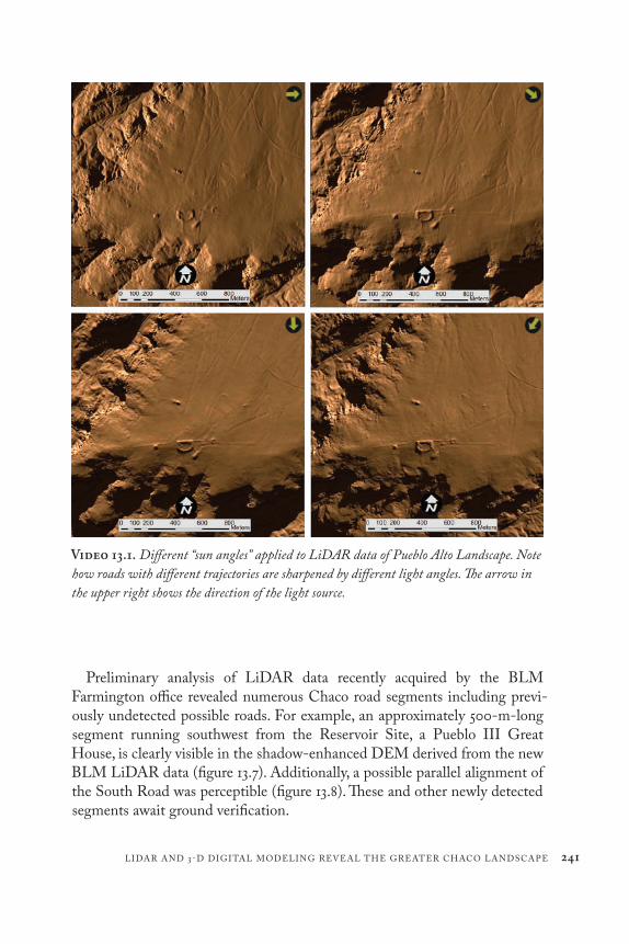
Manipulation of the direction (azimuth) and angle above the horizon of the light source proved a highly effective method for detecting, documenting, and measuring Chaco roads (video 13.1). The ability to change the sun angle using GIS has been critical for their recognition. Roads trending east- west, which are never shadow enhanced by natural east- west sun angles and therefore have been difficult to detect with traditional methodologies, were visible in the digital GIS environment.
Figure 13.3. The Aztec Airport Mesa Road in 1919. Note the monumental scale and white surface treatment. Wadleigh (1916:52).
danielpratt
Highlight
[link will be live after we register it with CrossRef]

240 RICHARD A. FRIEDMAN, ANNA SOFAER, AND ROBERT S. WEINER
Figure 13.4. The Aztec Airport Mesa Road in Soil Erosion Service aerial photography from 1934 (a); 2009 Google Earth Imagery (b); LiDAR data (c); and the road’s cross- sectional profile as documented by LiDAR (d).
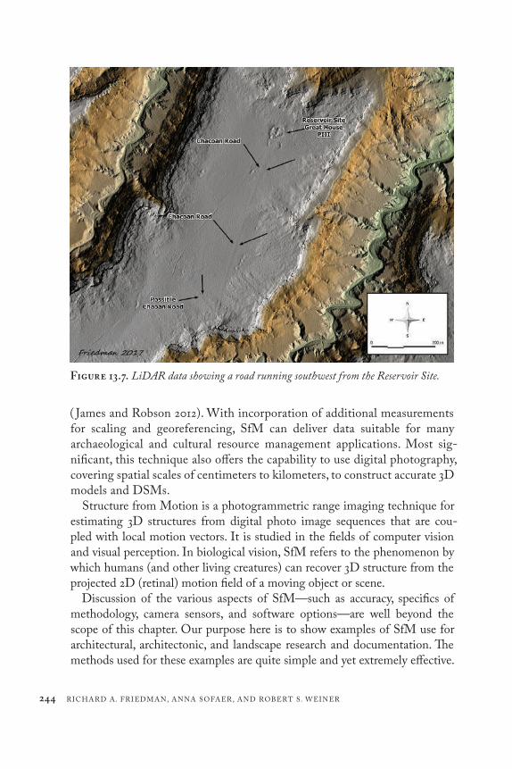
We were also able to quantitatively measure the morphology of Chaco roads at centimeter levels of relative vertical precision, which is not possible using traditional field methods. For example, figure 13.7 shows the cross- sectional profile of a previously undocumented segment of the North Road that has only 9.1 cm of vertical relief across a distance of approximately 9.5 meters. This road segment could never be seen on the ground, yet it is easily discernable using LiDAR data.
LIDAR AND 3- D DIGITAL MODELING REVEAL THE GREATER CHACO LANDSCAPE 241
Video 13.1. Different “sun angles” applied to LiDAR data of Pueblo Alto Landscape. Note how roads with different trajectories are sharpened by different light angles. The arrow in the upper right shows the direction of the light source.
Preliminary analysis of LiDAR data recently acquired by the BLM Farmington office revealed numerous Chaco road segments including previ-ously undetected possible roads. For example, an approximately 500- m- long segment running southwest from the Reservoir Site, a Pueblo III Great House, is clearly visible in the shadow- enhanced DEM derived from the new BLM LiDAR data (figure 13.7). Additionally, a possible parallel alignment of the South Road was perceptible (figure 13.8). These and other newly detected segments await ground verification.

242 RICHARD A. FRIEDMAN, ANNA SOFAER, AND ROBERT S. WEINER
As this brief discussion shows, LiDAR holds great promise for further cost- effective, widespread documentation of Chaco roads and the opportu-nity for in- depth study of their enigmatic character. Potential topics include investigating projected road alignments where no evidence has been visible on the ground; least cost path analyses of newly discovered roads; and road relationship with resource locations, settlement areas, landscape features, and astronomic- directional azimuths. In comparison to other areas of Chaco research, there has been relatively little investigation of Chaco roads since the large BLM studies of the 1980s. These features, however, hold profound
Figure 13.5. The Pueblo Alto Landscape as documented through various remote- sensing methods, including 1934 Soil Conservation Service aerial photography (a); 2005 with low sun angle NAIP photography (b); 2009 with standard sun angle (c); and hill- shaded LiDAR (d). Note the vast decrease in visibility over time and the clear definition of roads in the LiDAR image.

LIDAR AND 3- D DIGITAL MODELING REVEAL THE GREATER CHACO LANDSCAPE 243
insight into the priorities, values, planning, and beliefs of the ancient peoples of the Four Corners region. In the discussion below, we outline some sug-gestions for a large- scale renewed roads study building on the results of this preliminary work.
STRUCTURE FROM MOTION (SFM) PHOTOGRAMMETRY AND POLE AERIAL PHOTOGRAPHY
While LiDAR is an outstanding tool for landscape scale investigations, it can be costly and may be beyond the budget for many research and docu-mentation projects. An emerging photogrammetric technology known as Structure from Motion (SfM) can provide a more cost- effective alterna-tive for smaller landscape- scale projects and site excavation/documentation. Acquiring appropriate data for 3D photogrammetric measurement tradi-tionally required expensive instrumentation and significant expertise, but here we demonstrate an approach that uses only digital photographs taken with a consumer camera and commercial (or freely available) software
Figure 13.6. Twenty- times exaggerated vertical profile of a section of the North Road detected by LiDAR that is not visible on the ground.
244 RICHARD A. FRIEDMAN, ANNA SOFAER, AND ROBERT S. WEINER
Figure 13.7. LiDAR data showing a road running southwest from the Reservoir Site.
( James and Robson 2012). With incorporation of additional measurements for scaling and georeferencing, SfM can deliver data suitable for many archaeological and cultural resource management applications. Most sig-nificant, this technique also offers the capability to use digital photography, covering spatial scales of centimeters to kilometers, to construct accurate 3D models and DSMs.
Structure from Motion is a photogrammetric range imaging technique for estimating 3D structures from digital photo image sequences that are cou-pled with local motion vectors. It is studied in the fields of computer vision and visual perception. In biological vision, SfM refers to the phenomenon by which humans (and other living creatures) can recover 3D structure from the projected 2D (retinal) motion field of a moving object or scene.
Discussion of the various aspects of SfM— such as accuracy, specifics of methodology, camera sensors, and software options— are well beyond the scope of this chapter. Our purpose here is to show examples of SfM use for architectural, architectonic, and landscape research and documentation. The methods used for these examples are quite simple and yet extremely effective.

LIDAR AND 3- D DIGITAL MODELING REVEAL THE GREATER CHACO LANDSCAPE 245
For these projects, an aerial perspective was needed, but the use of a small Unmanned Aerial System (sUAS) was not feasible for a variety of reasons. The restrictions for “commercial” use of an sUAS at the time of the project required that a licensed airplane pilot fly the craft. This was well beyond the budget for the project, so the less expensive Pole Aerial Photography (PAP) option was selected. National Park Service regulations and visitor safety con-cerns would have also made the use of an sUAS much more difficult.
Instead, PAP was used to acquire photos from an aerial perspective. The setup used was similar to what is seen in figure 13.9 but often had multiple cameras mounted on the pole for improved data collection. The pole used was 7 m long, with the base of the pole inserted into a belt mounted cloth holder or pouch
Figure 13.8. Possible second, parallel alignment of the South Road in the new BLM LiDAR data.

246 RICHARD A. FRIEDMAN, ANNA SOFAER, AND ROBERT S. WEINER
(effectively increasing the maximum potential cam-era height to ~8 m). The stability of the pole was greatly enhanced by keep-ing the base in a relatively solid mount. The cameras were set to take images at an appropriate inter-val for a slow methodical walking speed. Typically, a 2- second interval was used, because it is much better to oversample the data rather than unders-ample and not have pho-tos that provide proper overlap to resolve the 3- D point cloud.
The cameras were consumer- grade Canon Sure Shot and GoPro action cameras. Due to the fish- eye lens of the GoPro cameras, they were typically most useful to ensure adequate cover-age of the subject. It was determined that for our application, the GoPro 3 or better cameras provide more than adequate accuracy (Helmholz et al. 2016), as long as movement of the camera was relatively slow to avoid distortion from the rolling shutter.
As a simple proof- in- concept exercise for the documentation of architec-ture and architectonic features, PAP was tested at Casa Cielo, a small Chaco outlier. The results from this study show an excellent comparison between data collected by this method versus “off the shelf ” photography and 1 m LiDAR data. The Casa Cielo video/photos (Video 2; figures 13.11a– b) dem-onstrates the differences between other data sources and the high- resolution
Figure 13.9. Example of a typical Pole Aerial Photography setup. Pierre Lesage via Flickr Creative Commons.

Video 13.2. Example PAP data from Casa Cielo Great House. 7 mm resolution orthophotograph derived from SFM photogrammetry. By R. Friedman.

248 RICHARD A. FRIEDMAN, ANNA SOFAER, AND ROBERT S. WEINER
photogrammetric products from low- altitude pole- based photography. Note the high detail of the site compared to other sources. The end of the video also illustrates its capability to generate textured 3D models for site visualization and long- term site condition assessment.
Another project focus was to create an accurate “as built” map of Kin Kletso, a Great House in Chaco Canyon (figure 13.10a– c). This effort provides an excellent example of how SfM technology can enable a single person to per-form 3D documentation of a moderately complex structure with a large spatial extent (approximately 50 × 20 m). While the creation of a 2D map was the primary focus of this project, the 3D data were an important by- product to aid in the creation of a 3D reconstruction of the massive building. The 3D recon-struction was then used in the creation of a physical model for exhibit in the Chaco Culture National Historical Park Visitor Center Museum.
For this project, the data was collected with a GoPro Hero 3 Silver (12 MP). Georeferencing and scaling of the model was provided by using survey- grade GPS receivers to obtain centimeter- level coordinate accuracy of locations that could easily and accurately be observed in the field and on the photography.
Figure 13.10. View of “as built” 3D model of Kin Kletso as it is today (a); example of a common map of Kin Kletso (from the Chaco Research Archive) (b). and map of Kin Kletso created using SfM- derived orthophotos and elevation data (c).

LIDAR AND 3- D DIGITAL MODELING REVEAL THE GREATER CHACO LANDSCAPE 249
This SfM documentation of Kin Kletso also led to numerous archaeological insights regarding the building’s form and errors in existing maps. First, north is incorrectly shown on some existing, widely distributed maps of the site (see, e.g., figure 13.10b). In figure 13.10b, it is assumed via cartographic convention that the north arrow is displaying true north, since there is no text or other indication of direction. It may be referencing magnetic north (or what was believed to be magnetic north on the original map); however, even then it would be considerably off: the approximate deviation from true north on this map is 24.62° W. An educated guess is that possibly the creator of the original map adjusted the magnetic declination on his/her compass the wrong direc-tion, thus doubling the magnetic declination value.
The north arrow in figure 13.10c depicts true north, or very nearly true north. The north arrow in this case is set to “grid” or projection north. The projection used for the map and original data is New Mexico State Plane Coordinate System, West Zone, NAD83, US Ft. This projection was selected over the pro-jection more commonly used Universal Transverse Mercator (UTM) projec-tion because Chaco Culture National Historical Park is split by UTM Zone 12N and UTM Zone 13N. The distortion of “grid” north versus true north at the edge of the UTM zone boundaries here is well over 1°.
Additionally, while all previously published maps show a complete wall with a closed room in the center of the building’s south side, our documentation revealed that no room ever existed there. There is no foundation or abutment for a wall in this location, which is currently the location of a National Park Service drainage system. Furthermore, this feature of Kin Kletso fits with the style of numerous McElmo Great Houses that have a similar “notch” for lad-ders. Finally, it became apparent that this “notch” is road related; it is the des-tination point of an ancient road visible in LiDAR data that connects 29SJ835, a monumental stepped platform mound on the south side of Chaco Canyon (see Stein et al. 2007:214– 216), with Kin Kletso.
We have also included images to illustrate how the data from the new 2D map of Kin Kletso were used to generate a 3D massing reconstruction of Kin Kletso. figure 13.11a shows the computer- generated and - rendered version of the model, and figure 13.11b shows the final physical model in the Chaco Culture National Historical Park Visitors Center Museum.
There are many other ways to capture photography for SfM documenta-tion for cultural resource research and documentation. Small Unmanned Aerial Systems (sUAS) are the most commonly used and extremely effective. However, there are times, situations, and locations in which using a sUAS may not be possible, such as a project in a wilderness area. While using a

250 RICHARD A. FRIEDMAN, ANNA SOFAER, AND ROBERT S. WEINER
pole to capture low- altitude aerial photography may be labor intensive, the low cost, ease, and simplicity of deployment make it a very viable method in many situations.
DISCUSSION AND CONCLUSIONIn this chapter we propose that wider use of the emerging technologies
of LiDAR and SfM can support vital documentation, management, and protection of greater Chaco landscapes, especially the fragile roads and their associated features that expand beyond Great House boundaries. This docu-mentation can also potentially assess aspects of the uniformity and distinc-tive character of sites throughout the larger Chaco cultural region, provide an overview of the grandeur of the Chaco Phenomenon, and deepen our understanding of its tremendous expanse. We suggest that wider landscape- scale mapping and precise 3D modeling of a Great House can help to reveal relationships of sites to celestial bodies, land formations, and other construc-tions, perhaps of different time periods. These central components of Chacoan complexes and their multifaceted landscapes must be taken into consider-ation when determining how to preserve them. The relationships (sometimes nonvisual) of Chacoan complexes with elements of the cosmos, the natural landscape, and other structures throughout time challenge notions of a “site” as confined to a single time period and physical location.
Thoughtful consideration of Native oral traditions is also critical to con-tinued engagement with and management of Chacoan sites. While these
Figure 13.11. Physical massing model created from computer model data in the Chaco Culture National Historical Park Museum (a); and computer- generated 3D massing model of Kin Kletso (b).

LIDAR AND 3- D DIGITAL MODELING REVEAL THE GREATER CHACO LANDSCAPE 251
historic associations and records often cannot be printed or reproduced, they can guide and illuminate work at Chaco sites and greatly foster respect for their continuing cultural significance and sensitivity.
While technology is a “moving target,” the results reviewed in this chapter demonstrate the great potential of LiDAR and SfM at this time to reveal previously unknown aspects of the archaeological record, redress errors in existing documentation, and produce a lasting, quantitative record of these sites. For example, while many Chaco roads are rapidly deteriorating and dis-appearing, LiDAR documentation captures x-, y-, and z-value data on road morphology that can be utilized by future researchers as roads continue to erode. When added to state archaeological databases such as the New Mexico Archaeological Records Management Section (ARMS), these recordings will provide critically needed legal protection to roads as archaeological sites under Section 106 legislation.
Finally, ground- truthing of newly detected roads and training a new gen-eration of archaeologists in road identification methods are key aspects of continued research and management of Chaco landscapes. Individuals with experience in the subtle art of road recognition should ground- truth possible road segment identified through LiDAR and other emerging technologies. Since only a few archaeologists have long- term experience and capability to identify roads on the ground, we recommend that they themselves train a new generation of archaeologists in the full suite of methodologies of Chaco roads study— including analysis of aerial photographs and other remotely sensed data, as well as ground- truthing. Such skills will be especially nec-essary to ground- truth the extremely subtle traces of roads revealed by new remote sensing techniques. We also recommend that a comprehensive Chaco roads study should include not only an analysis of landscapes associated with Bonito- era Great Houses, but all large sites/complexes from the Basketmaker III to Pueblo III periods where roads identified in previous studies have often been overlooked.
The Chaco culture conceived, planned, and coordinated the construction of Great Houses, roads, and earthworks across a vast region of challenging, high desert terrain. The intensely ritual nature of their sites and their many uniform characteristics suggest that a powerful ideology inspired this regional phenomenon. It appears to be time to consider Chaco’s regional culture across centuries as an accomplishment of equal standing among other such expan-sive cultures of the ancient world.
The complexity of the Chaco regional system, however, is often underap-preciated and oversimplified, in large part due to the remoteness and subtlety

252 RICHARD A. FRIEDMAN, ANNA SOFAER, AND ROBERT S. WEINER
of the remnants of Chacoan sites. In addition, it has taken decades of study to appreciate their multifaceted relationships to landscape features and celestial cycles. Emerging technologies will now allow us to re- create Chacoan sites in 3D models that bring them to life and reveal their full, formidable monu-mentality in their larger environments. Documentation of Great Houses and roads also creates lasting datasets so that sites can be preserved. These prod-ucts can then be shared to inspire the public, enrich scholarly studies, and foster appreciation of Chaco within a global perspective. Such efforts can also contribute to governmental support to protect Chaco and its invalu-able cultural heritage. Emerging technologies and new research are allow-ing us to appreciate Chaco’s deep significance on levels that are not easily comprehended but that suggest an immensely brilliant conceptual planning and envisioning.
ACKNOWLEDGMENTSWe thank Ruth Van Dyke, Carrie Heitman, and Steve Lekson for creating
and hosting the Chaco Landscapes: What We Know and What We Don’t Conference and inviting us to participate. We would also like to acknowl-edge the insights, research, and support over decades of John Stein, Michael Marshall, Taft Blackhorse, Phillip Tuwaletstiwa, John Roney, Dabney Ford, and William Stone. For early insights into the cosmological significance of landscape, we especially thank Alfonso Ortiz of Ohkay Owingeh. We appre-ciate the efforts of Brian Deaton, formerly of the BLM, to secure the recent LiDAR scan in the region surrounding Chaco and the National Trust for Historic Preservation for support to the LiDAR recording of the Great North Road. No permits were required for the research described above.
REFERENCESCameron, Catherine M. 2009. Chaco and After in the Northern San Juan: Excavations
at the Bluff Great House. University of Arizona Press, Tucson.Fowler, Andrew P., and John R. Stein. 1992. “The Anasazi Great House in Space,
Time, and Paradigm.” In Anasazi Regional Organization and the Chaco System, edited by David Doyel, 101– 122. Maxwell Museum of Anthropology Anthropo-logical Papers 5. University of New Mexico Press, Albuquerque.
Friedman, Richard, Dabney Ford, and John R. Stein. 1999. A Map of Padilla Wash Great House Landscape. Document on file at Chaco Culture National Historical Park, Nageezi, NM.

LIDAR AND 3- D DIGITAL MODELING REVEAL THE GREATER CHACO LANDSCAPE 253
Friedman, Richard A., Anna Sofaer, and Robert S. Weiner. 2017. “Remote Sensing of Chaco Roads Revisited: Lidar Documentation of the Great North Road, Pueblo Alto Landscape, and Aztec Airport Mesa Road.” Advances in Archaeological Prac-tice 5(4):365– 381.
Guiterman, Christopher H., Thomas W. Swetnam, and Jeffrey S. Dean. 2016. “Eleventh- Century Shift in Timber Procurement Areas for the Great Houses of Chaco Canyon.” Proceedings of the National Academy of Sciences 113, no. 5 (February): 1186– 1190. DOI: 10.1073/pnas.1514272112.
Helmholz, Petra, John Long, T. Munsie, and David Belton. 2016. “Accuracy Assess-ment of GoPro Hero 3 (Black) Camera in Underwater Environment.” Inter-national Archives of the Photogrammetry, Remote Sensing and Spatial Information Sciences, vols. 41- B5 and 23, 477– 483. ISPRS Congress, July 2016, 12– 19, Prague.
James, Mike R., and Stuart Robson. 2012. “Straightforward Reconstruction of 3D Surfaces and Topography with a Camera: Accuracy and Geoscience Application.” Journal of Geophysical Research 117, F03017. doi:10.1029/2011JF002289. Advances in Archaeological Practice 5(4):365– 381.
Judd, Neil M. 1954. The Material Culture of Pueblo Bonito. Smithsonian Miscellaneous Collections 124. Smithsonian Institution, Washington, DC.
Kantner, John, and Nancy M. Mahoney. 2000. “Great House Communities across the Chacoan Landscape.” Anthropological Papers of the University of Arizona no. 64. University of Arizona Press, Tucson.
Lekson, Stephen H. 2015. The Chaco Meridian: One Thousand Years of Political and Religious Power in the Ancient Southwest. 2nd ed. Rowman and Littlefield, Lanham, MD.
Malville, J. McKim. 2004. “Ceremony and Astronomy at Chimney Rock.” In Chim-ney Rock: The Ultimate Outlier, edited by J. McKim Malville, 131– 150. Lexington Books, Lanham, MD.
Marshall, Michael P. 1997. “The Chacoan Roads: A Cosmological Interpretation.” In Anasazi Architecture and American Design, edited by Baker H. Morrow and V. B. Price, 62– 74. University of New Mexico Press, Albuquerque.
Marshall, Michael P., and Anna P. Sofaer. 1988. “Solstice Project Archaeological Investigations in the Chaco District 1984 and 1985: The Technical Report.” Manu-script on file, Laboratory of Anthropology, Santa Fe, NM.
Marshall, Michael P., John R. Stein, Richard W. Loose, and Judith E. Novotny. 1979. Anasazi Communities of the San Juan Basin. Historic Preservation Bureau, Santa Fe, NM.
Nials, Fred L. 1983. “Physical Characteristics of Chacoan Roads.” In Chaco Roads Project, Phase 1: A Reappraisal of Prehistoric Roads in the San Juan Basin, edited by Chris Kincaid, 6. 1- 6. 51. Bureau of Land Management, Albuquerque.
danielpratt
Highlight
AU: Correct that two journal titles are associated with this article?

254 RICHARD A. FRIEDMAN, ANNA SOFAER, AND ROBERT S. WEINER
Nials, Fred L., John R. Stein, and John R. Roney. 1987. Chacoan Roads in the South-ern Periphery: Results of Phase II of the BLM Chaco Roads Project. Bureau of Land Management, Albuquerque.
Ortiz, Alfonso. 1969. The Tewa World: Space, Time, Being, and Becoming in Pueblo Society. University of Chicago Press, Chicago.
Pepper, George H. 1920. “Pueblo Bonito.” Anthropological Papers No. 27. American Museum of Natural History, New York.
Powers, Robert P., William B. Gillespie, and Stephen H. Lekson. 1983. “The Outlier Survey: A Regional View of Settlement in the San Juan Basin.” Reports of the Chaco Center No. 3. National Park Service, Albuquerque.
Roney, John R. 1992. “Prehistoric Roads and Regional Integration in the Chacoan System.” In Anasazi Regional Organization and the Chaco System, edited by David E. Doyel, 123– 132. Anthropological Papers No. 5. Maxwell Museum of Anthropol-ogy, Albuquerque.
Ruppe’, Trish, John R. Stein, Richard Friedman, and Taft Blackhorse. 2001. “Chacoan Roads on the Eastern Chuska Slope.” Paper presented at Sixty- Sixth Annual Meeting of the Society for American Archaeology, New Orleans.
Sofaer, Anna P. 1999. The Mystery of Chaco Canyon. Documentary film. Bullfrog Films, Oley, PA.
Sofaer, Anna P. 2007. “The Primary Architecture of The Chacoan Culture: A Cos-mological Expression.” In The Architecture of Chaco Canyon, New Mexico, edited by Stephen H. Lekson, 225– 254. University of Utah Press, Salt Lake City.
Sofaer, Anna, Michael P. Marshall, and Rolf M. Sinclair. 1989. “The Great North Road: A Cosmographic Expression of the Chaco Culture of New Mexico.” In World Archaeoastronomy, edited by Anthony F. Aveni, 365– 376. Cambridge Univer-sity Press, Cambridge.
Sofaer, Anna, and Rolf M. Sinclair. 1983. “Astronomical Markings at Three Sites on Fajada Butte.” In Astronomy and Ceremony in the Prehistoric Southwest, edited by John B. Carlson and W. James Judge, 13– 70. Maxwell Museum of Anthropology Anthropological Papers No. 2. University of New Mexico, Albuquerque.
Sofaer Anna, Rolf M. Sinclair, and L. E. Doggett. 1982. “Lunar Markings on Fajada Butte, Chaco Canyon.” In Archaeoastronomy in the New World, edited by Anthony F. Aveni, 169– 181. Cambridge University Press, Cambridge.
Sofaer Anna, Robert S. Weiner, and William Stone. 2017. “Inter- site Alignments of Prehistoric Shrines in Chaco Canyon to the Major Lunar Standstill.” In The Sci-ence of Time 2016: Time in Astronomy and Society, Past, Present and Future, edited by Elisa Felicitas Arias, Ludwig Combrinck, Pavel Gabor, Catherine Hohenkerk, and P. Kenneth Seidelmann, 79– 102. Astrophysics and Space Science Proceedings Vol 50. Springer, Cham, Germany.

LIDAR AND 3- D DIGITAL MODELING REVEAL THE GREATER CHACO LANDSCAPE 255
Sofaer Anna, Volker Zinser, and Rolf M. Sinclair. 1979. “A Unique Solar Marking Construct.” Science 206(4416):283– 291.
Stein, John R. 1983. “Road Corridor Descriptions.” In Chaco Roads Project, Phase 1: A Reappraisal of Prehistoric Roads in the San Juan Basin, edited by Chris Kincaid,8- 1– 8- 15. Bureau of Land Management, New Mexico, Albuquerque.
Stein, John, Richard Friedman, Taft Blackhorse, and Richard Loose. 2007. “Revisit-ing Downtown Chaco.” In The Architecture of Chaco Canyon, New Mexico, edited by Stephen H. Lekson, 199– 224. University of Utah Press, Salt Lake City.
Stein, John R., and Stephen H. Lekson. 1992. “Anasazi Ritual Landscapes.” In Ana-sazi Regional Organization and the Chaco System, edited by David Doyel, 87– 100. Maxwell Museum of Anthropology Anthropological Papers 5. University of New Mexico Press, Albuquerque.
Van Dyke, Ruth M. 2007. The Chaco Experience: Landscape and Ideology at the Center Place. School for Advanced Research Press, Santa Fe, NM.
Wadleigh, F. A. 1916. “Ancient Road Near Aztec, N.M.” El Palacio 3(4):52.Weiner, Robert S. 2018. “Sociopolitical, Ceremonial, and Economic Aspects of
Gambling in Ancient North America: A Case Study of Chaco Canyon.” American Antiquity 83(1):34– 53.
White, Leslie A. 1942. “The Pueblo of Santa Ana, New Mexico.” Memoirs of the American Anthropological Association 60. American Anthropological Association, Menasha, WI.
White, Leslie A. 1960. “The World of the Keresan Pueblo Indians.” In Culture in History: Essays in Honor of Paul Radin, edited by Stanley Diamond, 53– 64. Colum-bia University Press, New York.