Transcript of Ricardo Antunes, Arthur Kopelman, Paul Sieswerda, Robert ...
Ricardo Antunes, Arthur Kopelman, Paul Sieswerda, Robert DiGiovanni,Chris Spagnoli, Catherine Granton, Howard Rosenbaum
Presenter
Presentation Notes
Large whales can be found year-round in the waters of the New York Bight, which is in the migratory pathways for several endangered and recovering species. Information on whale distribution and behavior in the New York Bight could be improved, and baseline and more in-depth information is needed for management and conservation planning, especially in the context of growing concerns about the impacts of ship strikes, entanglements and planning for offshore wind energy. Here we present 463 humpback and 1348 fin whale previously unpublished records, spanning between 1981 and 2014, collected from whale watching operations in the New York Bight. Sighting positions were used to model the spatial patterns of occurrence as a function of static (depth, distance from coast, distance from 200m isobath) and dynamic (Chlorophyl a concentration, sea surface temperature) environmental covariates, using boosted logistic regression trees. Modeled distribution for both species' was mostly explained by static variables with some contribution from surface temperature for humpback whales. Predicted humpback whale distribution was more coastal than for fin whales. To allow the spatially explicit assessment of the risks to whales from anthropogenic activities we overlaid the modeled whale species' distribution maps on the spatial distribution of potentially impacting anthropogenic activities such as shipping intensity, fisheries activity and renewable energy developments. An index combining the modeled whale spatial distribution and spatial distribution of anthropogenic activities was calculated and results are discussed in the context of marine spatial planning for the New York seascape. �
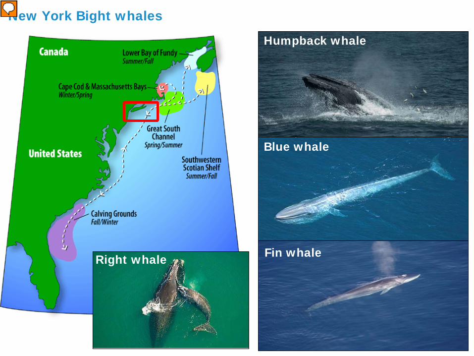
Blue whale
Fin whaleRight whale
New York Bight whales
Humpback whale
Presenter
Presentation Notes
Large whales can be found year-round in the waters of the New York Bight, which is in the migratory pathways for several endangered and recovering species
Potentially impacting anthropogenic activities
Presenter
Presentation Notes
Large whales can be found year-round in the waters of the New York Bight, which is in the migratory pathways for several endangered and recovering species. Information on whale distribution and behavior in the New York Bight could be improved, and baseline and more in-depth information is needed for management and conservation planning, especially in the context of growing concerns about the impacts of ship strikes, entanglements and planning for offshore wind energy.
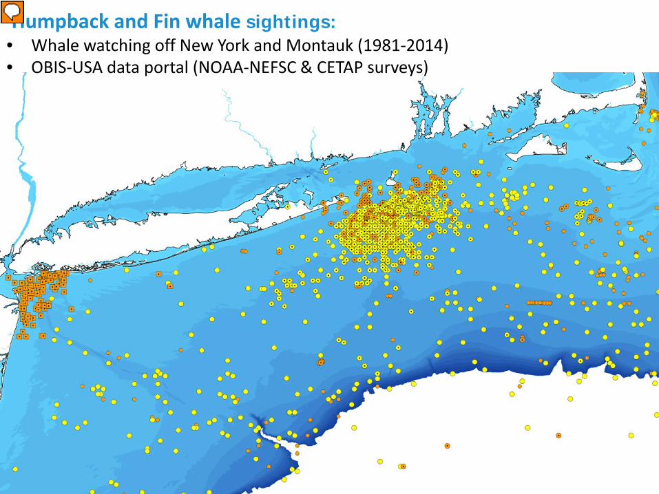
Humpback and Fin whale sightings:• Whale watching off New York and Montauk (1981-2014)• OBIS-USA data portal (NOAA-NEFSC & CETAP surveys)
Presenter
Presentation Notes
Here we present 463 humpback and 1348 fin whale previously unpublished records, spanning between 1981 and 2014, collected from whale watching operations in the New York Bight. Sighting positions were used to model the spatial patterns of occurrence as a function of static (depth, distance from coast, distance from 200m isobath) and dynamic (Chlorophyl a concentration, sea surface temperature) environmental covariates, using boosted logistic regression trees
Spatial modeling
• Sightings taken as presence locations• Random locations taken as pseudo-absences• Environmental covariate values extracted at presence/pseudo-absence locations
Static: Depth, distance from coastDynamic: daily temperature, weekly Chl a average
• Generalized Boosted (binomial) Regression Trees Modeling• Predictions made weekly and averaged
Fin whale Humpback whale
Presenter
Presentation Notes
. To allow the spatially explicit assessment of the risks to whales from anthropogenic activities we overlaid the modeled whale species' distribution maps on the spatial distribution of potentially impacting anthropogenic activities such as shipping intensity, fisheries activity and renewable energy developments
Potentially impacting anthropogenic activities: spatial distribution
Whale watching
Offshore wind
Shipping
BOEM current and planned leases
Kernel-density fromWW sightings (all sps.)AIS (The Nature Conservancy )
Presenter
Presentation Notes
. To allow the spatially explicit assessment of the risks to whales from anthropogenic activities we overlaid the modeled whale species' distribution maps on the spatial distribution of potentially impacting anthropogenic activities such as shipping intensity, fisheries activity and renewable energy developments
Spatially explicit cumulative impact index
Fin whale Humpback whale
• High impact areas: New York harbor entrance, south of Block island
• Ongoing analysis include other minke whales, fisheries data and weighting of impacts


![ANTÓNIO LOBO ANTUNES: ORIGAMI ESPÁCIO-TEMPORAL“NIO LOBO ANTUNES: ORIGAMI ESPÁCIO-TEMPORAL [ANTÓNIO LOBO ANTUNES: SPATIOTEMPORAL ORIGAMI] by BRUNO GONÇALO NOGUEIRA SALES (Under](https://static.fdocuments.in/doc/165x107/5ae2d33b7f8b9ae74a8cf0db/antnio-lobo-antunes-origami-espcio-temporal-lobo-antunes-origami-espcio-temporal.jpg)


