RIAI Submission on the Draft Fingal County Development ... · on the Draft Fingal County...
29
- 1 - RIAI Submission on the Draft Fingal County Development Plan 2011-2017 14 June 2010
Transcript of RIAI Submission on the Draft Fingal County Development ... · on the Draft Fingal County...
- 1 -
RIAI Submission on the Draft Fingal County Development Plan 2011-2017 14 June 2010
- 2 -
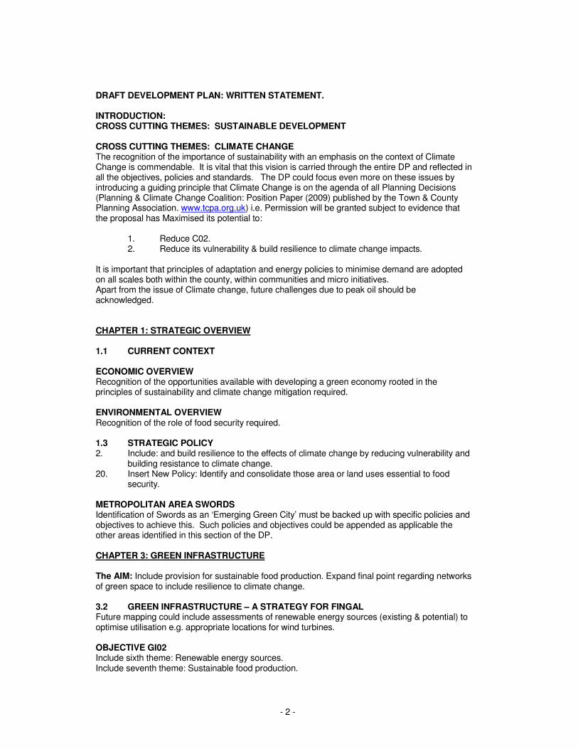
DRAFT DEVELOPMENT PLAN: WRITTEN STATEMENT. INTRODUCTION: CROSS CUTTING THEMES: SUSTAINABLE DEVELOPMENT CROSS CUTTING THEMES: CLIMATE CHANGE The recognition of the importance of sustainability with an emphasis on the context of Climate Change is commendable. It is vital that this vision is carried through the entire DP and reflected in all the objectives, policies and standards. The DP could focus even more on these issues by introducing a guiding principle that Climate Change is on the agenda of all Planning Decisions (Planning & Climate Change Coalition: Position Paper (2009) published by the Town & County Planning Association. www.tcpa.org.uk) i.e. Permission will be granted subject to evidence that the proposal has Maximised its potential to: 1. Reduce C02. 2. Reduce its vulnerability & build resilience to climate change impacts. It is important that principles of adaptation and energy policies to minimise demand are adopted on all scales both within the county, within communities and micro initiatives. Apart from the issue of Climate change, future challenges due to peak oil should be acknowledged. CHAPTER 1: STRATEGIC OVERVIEW 1.1 CURRENT CONTEXT ECONOMIC OVERVIEW Recognition of the opportunities available with developing a green economy rooted in the principles of sustainability and climate change mitigation required. ENVIRONMENTAL OVERVIEW Recognition of the role of food security required. 1.3 STRATEGIC POLICY 2. Include: and build resilience to the effects of climate change by reducing vulnerability and building resistance to climate change. 20. Insert New Policy: Identify and consolidate those area or land uses essential to food security. METROPOLITAN AREA SWORDS Identification of Swords as an ‘Emerging Green City’ must be backed up with specific policies and objectives to achieve this. Such policies and objectives could be appended as applicable the other areas identified in this section of the DP. CHAPTER 3: GREEN INFRASTRUCTURE The AIM: Include provision for sustainable food production. Expand final point regarding networks of green space to include resilience to climate change. 3.2 GREEN INFRASTRUCTURE – A STRATEGY FOR FINGAL Future mapping could include assessments of renewable energy sources (existing & potential) to optimise utilisation e.g. appropriate locations for wind turbines. OBJECTIVE GI02 Include sixth theme: Renewable energy sources. Include seventh theme: Sustainable food production.
- 3 -
Mapping could include identification and quantification of carbon stores i.e. forest and bogs and grassland. Maps could identify land losing carbon and provide policy to mitigate that loss. Include new OBJECTIVE GI06+ Develop Green Development process to co-develop green infrastructure e.g. water, waste, food in conjunction with other infrastructure e.g. public buildings, roads etc for all new development sites. FINGAL’S GREEN INFRASTRUCTURE The proposed new themes i.e. renewable energy sources and sustainable food production should be included here as follows: RENEWABLE ENERGY SOURCES
• Identify appropriate areas for wind turbines, geothermal, AD, local biomass and district heating.
SUSTAINABLE FOOD PRODUCTION
• Identify current food production areas
• Identify how such areas can be consolidated
• Identify possible future areas for food production including urban agriculture e.g. proposed organic allotments on undeveloped land.
GREEN INFRASTRUCTURE & LOCAL AREA PLANS OBJECTIVE GI20 The proposed new themes i.e. renewable energy sources and sustainable food production should be included here. GREEN INFRASTRUCTURE & DEVELOPMENT The proposed new themes i.e. renewable energy sources and sustainable food production should be included here. PROPOSED OBJECTIVE G11+ Require all new Development to maximise its potential to reduce its C02 emissions, reduce its vulnerability and build resistance to climate change impacts. OBJECTIVE GI13 Define extent of ‘major development’. 3.3 GREEN INFRASTRUCTURE OBJECTIVES FOR LAPs & DEVELOPMENT PROPOSALS SUSTAINABLE WATER MANAGEMENT THEME NEW OBJECTIVE GI33+ Provision or incentives to encourage grey water recycling. OBJECTIVES FOR THEME OF FOOD SECURITY NEW OBJECTIVE G1+ Require temporary use of all undeveloped land as organic allotments to promote food security and community resilience to climate change and to provide a local residential amenity. CHAPTER 4: PHYSICAL INFRASTRUCTURE BICYCLE PARKING REQUIRMENTS The cycle parking standards are not adequate to satisfy the objectives promoting sustainable transport. In particular the cycle parking standard per dwelling should be min 1 no. space per bed space. Cycle standards should also incorporate spaces for electric scooters and bicycles to include recharging points.
- 4 -
In addition the provision of (privately run), secure cycle parks should be encouraged at public transport nodes and in the vicinity of suburban train/METRO stations. PUBLIC TRANSPORT INTERCHANGES Integration of all public transport systems should also explicitly include integration of pedestrian and cycle routes. The DP wishes to recognise the ever present demand for private car use. The DP should facilitate the alternatives encouraging the provision of (privately run), secure cycle parks should be encouraged at public transport nodes and in the vicinity of suburban train/METRO stations. CAR PARKING EXPAND OBJECTIVE TO 60 Include criteria (d) is constructed of permeable paving in accordance with SuDs. CAR PARKING STANDARDS Car Parking standards should include minimum requirements for electric vehicle charge points e.g. provision for non-residential developments shall provide facilities for battery operated cars to be recharged at a rate of 10% of the total car parking spaces (metered-fast charging 220-240V, 32A three phase), The remainder of the parking spaces, as for all residential spaces including parking spaces for the disabled, shall be constructed to be capable of accommodating future charging points as required’. Multi- storey car parks should also include recharging points. ROAD SAFTEY Include standards regarding size of cycle paths and surface specifications. ELECTRIC VEHICLES See CAR PARKING STANDARDS above – DP should take opportunity to lead in this field. ROAD CONSTRUCTION AND IMPROVEMENT MEASURES Include Road capacity Improvements with a specific policy regarding the improvement of existing cycle lanes including widening 4.2 WATER SERVICES DRINKING WATER SUPPLY Include new OBJECTIVE DW07+ Require water supply management plan to be submitted as part of the planning application for large developments. Include new OBJECTIVE DW07++ Encourage rain water harvesting & grey water recycling. The DP could include minimum standards for rainwater harvesting for all new developments e.g. provision of a min 190 Litre rain water butt per house or house with non exempt extension and requirement of landscaping design proposals for larger developments to incorporate rainwater harvesting for irrigation where appropriate. 4.3 ENERGY The DP should include provision of mapping wind and other renewable energy opportunities as part of the Green Infrastructure mapping (see 3.2 above). SOLAR Include new OBJECTIVE EN08+ The DP should include clear policy regarding the right to solar energy to run solar collectors (panels & photovoltaic) for establishing the impact of new developments on existing property.
- 5 -
CHAPTER 7: URBAN FINGAL ADVERTISING SIGNAGE Include new OBJECTIVE UC21+ Require Low energy options e.g. 5 watts per sq m advertising (which could be augmented by photovoltaic’s etc) to reduce the energy use. SUSTAINABLE PLACEMAKING Include new OBJECTIVE UD10+ Ensure critical mass development to support community, infrastructure and services facilities. HOUSING DENSITY Density standards can be quite blunt relating units per hectare which are generally applicable to larger scale development. The DP must be cognizant that such large scale development is unlikely in the short to medium term. New Development will be primarily one-offs or small scale and the DP policies must reflect this. Higher residential densities should be achieved in appropriate urban areas including increasing the density of existing low density housing. The LAP’s must address the densification of existing housing in a co-ordinated manner and the following micro density guidelines should apply (in tandem with LAP and 3-dimensional mapping):
• Encourage the sub-division of existing large residential housing while achieving improved energy performance.
• Facilitate upward extension by up to 2 storeys and horizontal sub division.
• Permit forward extension to reduce front gardens to 25m2 minimum and the policy of preservation of the existing building line should be modified in favour of a more flexible approach based on the merits of each individual scenario.
• Encourage District Energy Provision and the location of community located CHP as part of the overall design strategy
• Encourage Compact urban / settlement design.
• Require spaces which are people orientated and are designed to a human scale. REFUSE BINS Include new OBJECTIVE RD26+ Ensure new housing schemes include provision for composting facilities. ADDITIONAL PROPOSALS Residential Development Control Standards should include:
• Explicitly provide for community energy provision in appropriate areas.
• Discourage proven unsustainable materials.
• Ensure control standard will not adversely affect attempts at passive design, inclusion of renewable, or design for improved energy performance etc. See also 1.2.2 above. This is particularly applicable in rural areas with very specific site technical requirements such as parking offset or building line. The Development Plan must acknowledge that this is can be counter productive to sustainable design.
• Ensure sustainable design does not fail because of misguided aesthetic or visual reasons i.e. it may not necessarily reflect the existing character, appearance or materials employed in the surrounding area.
• Require alternative approaches to road/footpath arrangements to avoid large hard standing areas. Alternative approaches could include the concept of living streets (or ‘Woonerf’ (the Netherlands) or ‘home-zones’ (the UK) where the external circulation space is considered a social space designed to be shared by pedestrians, playing children, bicyclists, and low speed motor vehicles. These approaches can be applied to both proposed and existing streets.include reference to Guidance on permeable paving
- 6 -
for front gardens: www.communities.gov.uk/documents/planningandbuilding/pdf/pavingfrontgardens.pdf
Change of use/Alterations Control Standards should:
• Make reference to national guidelines such as Passive House Retrofit Guidelines: www.seai.ie/Publications/Renewables_Publications/Passive_House_Retrofit_Guidelines.pdf
• Provision or Incentives within the Development Plan to encourage recycled materials.
• Prioritize upgrading the fabric of existing buildings in lieu of demolition. Planning Applications in respect of the material alteration of the external fabric of a building should be supported.
7.5 OPEN SPACE: QUANTITY Include requirement to provide sufficient quantities of community gardening provision e.g. allotments. HIERARCHY & ACCESSIBILITY Types of public open space should recognise community gardening provision where appropriate. Standards regarding overall land provision and minimum plot sizes should also be included e.g.
• minimum standards for allotments
• Allotment leases are held for a minimum and maximum of 5 years.
• Tool sheds are limited to 2m height and a maximum floor area of 3m2 and must be demountable for reuse elsewhere.
• Poly tunnels and glasshouses must be no higher that 3m and have an aggregate area of no more than 10% of the area of the allotment.
CHAPTER 8: RURAL FINGAL HOUSING IN THE COUNTRYSIDE-RURAL DRAINAGE Development requirements of on-site treatment systems should not preclude proposals for alternative approaches such as Reed bed systems or energy positive vacuum waste transportation. Indeed these systems should be the favoured approach. Community based AD (Anaerobic Digestion) plants should be incentivized. Waste water treatment plants to be assessed e.g. vulnerability given their location to flood exposure or their reliance on electricity grid. COUNTRY MARKETS DEVELOP OBJECTIVE RE15 Mapping of suitable locations for such markets in relation to locally produced food should form part of the Green Infrastructure mapping plan as part of the proposed seventh sustainable food production theme. Identify new market locations or to restore historic market locations that have fallen into misuse. Market locations should be supplied as far as practicable by local agriculture either rural or urban WALKING & CYCLING NEW OBJECTIVE RE42+ Identify & map of rural roads with designation of green roads within the Local Authority where pedestrians and cyclists are prioritized with low speed limits, restricted sight lines, and integral calming measures (hills, hollows trees etc.). Where such rural roads are identified hedgerows, native tress, and real local stone walls should be reinstated and inappropriate walls and fences to be removed restoring linear hedgerows. APPENDIX 2: RETAIL STRATEGY This section should require new supermarkets to be naturally lit and be powered by tri-generation CHP units (provides power, heat and coolth). Supermarkets have amongst the highest energy use per sq.m due to artificial lighting and most of all refrigeration. There should be plot ratio and

- 7 -
density guidelines regarding this form of development to maximize site potential in keeping with good urban design. APPENDIX 5: INTERIM SITING & DESIGN GUIDANCE FOR RURAL HOUSING The following additional provisions to be included in assessing planning applications for a rural house:
• Promote the use of locally sourced materials, materials with low embodied energy or recycled materials, where possible.
ADDITIONAL PROPOSALS: 1. Consider requiring all new Development to submit an assessment of its overall sustainability similar to the RIAI checklist for sustainable buildings V8 [Appendix A]. 2. Objectives regarding Retrofit & Re-generation to include: a. Recycling and re use of existing buildings on brown field infill sites. This could include incentives such as reduced financial contributions or relaxed Development Control Standards. b. Alterations of buildings to yield improvements to the existing building fabric. 3. Design Standards to include: a. Appropriate and flexible design standards particularly in relation to building & site geometry. The Development Plan should make provision for assessment of design standards on a case by case basis e.g. reliance on staunch site design standards should not be at the expense of passive design measures. b. Design which optimizes:
- Orientation and passive solar gain and Thermal Mass opportunities. - Natural lighting and ventilation where possible, avoiding generous floor to ceiling heights and avoidance of deep plan building.
c. Design which can be adapted to respond to Climate Change. 4. Materials to include a. Provision or incentives within the Development Plan to encourage the use of materials with low embodied energy. b. Provision or Incentives within the Development Plan to promote locally sourced or recycled materials. c. Provision or Incentives within the Development Plan to encourage the design of structures for ease of disassembly. 5. Energy efficiency to include a. Provision or Incentives within the Development Plan to encourage district wide heating /cooling systems. The Development Plan should consider retrofit District Energy Provision. There should be a strategic view for provision of more efficient energy supply to localities both in areas of regeneration or existing buildings e.g. encourage the location of community located CHP as part of the overall design strategy. b. Provision or Incentives within the Development Plan to encourage construction methods and materials which require less energy to produce / install. 6. Impact of Construction to include a. Requirement for the assessment of environmental impact of operations on site appropriate to the scale of the development. b. Requirement for the assessment of the environmental impact of transportation to site appropriate to the scale of the development.
- 8 -
7. Lighting a. Ban electric & gas outdoor heaters. b. Require Low energy options for floodlighting. c. Consider urban night time lighting. Images of the earth at night illustrate the extent of energy use at night attributable to lighting. The DP could include a policy to minimize any superfluous lighting at night particularly with regarding to commercial premises not in use at night but permanently lit. This would also provide a strong visual image illustrating a Local Authority’s commitment to a low carbon reality. RESIDENTIAL DEVELOPMENT. Objective RD25 "Ensure new terraced townhouse duplex and apartment schemes include appropriate design measures for refuse bins, details of which should be clearly shown at preplanning and planning application stage and which cannot be situated immediately to the front door or ground floor window." The RIAI fully support the principle of careful consideration of waste management storage bins at design stage, however the phrase “which cannot be situated immediately to the front door or ground floor window." is of concern since it may be unnecessarily prescriptive The RIAI suggest the wording to read “should not be situated immediately to the front door or ground floor window, unless adequate screened alcoves or other such mitigation measures are utilized…” CAR PARKING STANDARDS IN RESIDENTIAL DEVELOPMENTS. Car-parking standards in residential areas: the requirement for 2 car-parking spaces in-curtilage for 3-bedroomed dwellings is overly prescriptive and will, in our opinion, prove problematic in the achievement of sustainable densities where schemes are predominantly houses as opposed to apartments, for obvious reasons. It will also prove difficult to provide adjacent visitor parking, particularly in circumstances where smaller sized terraced housing is provided, because the entire frontage will be taken up with vehicle access to the curtilage, thereby preventing the provision for any road-side parking. The provision of only one (preferably none) in-curtilage spaces, with parking provision principally on-street, allows for a more flexible solution - where some residents have only one car (some none) and some having more than two. Obviously there can be some consumer resistance to this. However it can be shown that this can prove the most acceptable solution for the greater number of residents. In the Context of Universal Design (original text of development plan is added to by RIAI underlined text) SMARTER TRAVEL – A SUSTAINABLE TRANSPORT FUTURE – A NEW TRANSPORT POLICY FOR IRELAND 2009-2020 This document aims to deliver a sustainable transport system as an important dimension of the climate change agenda. The Government reaffirms its vision for sustainability in transport and sets out five key goals: (i) to reduce overall travel demand, (ii) to maximise the efficiency of the transport network, (iii) to reduce reliance on fossil fuels, (iv) to reduce transport emissions and (v) to improve UNIVERSAL accessibility to transport and improve our quality of life. NATIONAL CYCLE POLICY FRAMEWORK 2009-2020 This document sets out actions to deliver a new culture of cycling in Ireland by 2020, with 10% of all trips to work being made by bicycle within the next twelve years, THIS SHOULD INCLUDE MEASURES TO HELP THOSE WITH AUDIAL IMPAIRMENTS
- 9 -
PROGRESSING RURAL PUBLIC TRANSPORT IN IRELAND 2006 Projections indicate that an estimated 450,000 rural dwellers could have unmet transport needs by 2021, including 250,000 people in key target groups, older people, young people, people on low incomes, and people with mobility, sensory or cognitive impairments. Issues relating to connectivity within the rural hinterland are therefore of relevance to the County and its Development Plan. INTEGRATED LAND USE AND TRANSPORTATION The integration of land-use and transport is the most effective way of providing an efficient transportation system and is essential in the provision of a sustainable spatial framework for economic, social and cultural development. By organising the pattern of development and influencing its location, mix, density and scale, the integration of land use with transportation can serve to reduce the overall need to travel and/or facilitate sustainable development and Universal design requirements. Ensuring that the places where people live are either close to, or are connected by public transport to, their places of work or education, allows people to use the most sustainable modes of transport, namely walking, cycling, and public transport. In general the private car is an unsustainable mode of transport, especially single occupancy cars during congested peak periods. Allowing higher density development to occur along public transport corridors increases the number of people within the walking catchment of the public transport service, which in turn increases the patronage of the service, and leads to an increase in its financial and economic viability and positive environmental impact. This reduces the demand for transport, and is therefore part of the demand management measures identified in Transport 21 and A Platform for Change. The growth in population within Fingal and the continued increase in car ownership (86.1% of households of the County having at least one motor car, Census 2006 Table 37) will have serious consequences for the County if land use and transportation policies are not integrated. Within this context high densities and mixed uses will be encouraged to locate within walking distance of public transport nodes and at accessible sites throughout the County, such as those within town centres. The provision of an integrated land use and transportation system, although a long term process, will reduce the effects of transport on the built and natural environment and encourage healthier travel choices. In developing an integrated land use and transportation policy it should be noted that land uses that generate large numbers of Heavy Goods Vehicles should be situated adjacent to good road networks and away from town centres. Objective TO1 (P93) Support the sustainability principles set out in the National Spatial Strategy, the Dublin Transportation Office’s A Platform for Change 2000-2016, the Regional Planning Guidelines for the Greater Dublin Area and the document Smarter Travel, A Sustainable Transport Future 2009 – 2020 and ensure that land use and zoning are integrated with transportation, especially along public transport corridors/nodes and at accessible urban sites. Objective TO2 Support the provision of high density and mixed use development along public transport corridors where public transport capacity and accessibility exists. Objective TO6 Continue to ensure walking and cycling facilities and networks are designed so that they are safe and meet the needs of people with disabilities. Including segregation of cyclists and pedestrians
- 10 -
Objective TO9 Promote walking by continually upgrading the condition of existing footpaths throughout the county, and provide controlled and uncontrolled crossings where warranted at all major crossing points, which should include dished pavements for access for all. Objective TO17 Require planning applications to demonstrate the development proposal’s accessibility for Pedestrians, cyclists and people with mobile, sensory and cognitive impairments. Planning applications for residential/commercial or mixed use developments need to:……………. PARK AND RIDE The purpose of a ‘Park and Ride’ facility is to encourage car commuters to transfer to public transport, thereby reducing congestion and promoting public transport. A policy in this regard is in line with DTO recommendations and will promote the achievement of sustainable development. Park and Ride facilities have the benefit of reducing car journeys, easing congestion, and acting as a substitute for urban centre car parking. Objective TO18 Promote and support the provision of Park and Ride facilities at suitable interchange points within the County. To this end the Council will facilitate measures and schemes to make interchanging easier, i.e. by the development and promotion of several initiatives such as the building of infrastructure and ‘soft’ measures including the provision of better travel/passenger information. Facilities should include proper shelter seating, accurate information on all local bus and train/metro/dart services, binprovision, and facilities to cater for persons with special need requirements e.g. provision of large print, braille or audio versions of all timetables as well as allowing for disabled parking to allow for easy access to public transport. Objective TO25 (92) Improve facilities and encourage transport agencies/transport providers to improve facilities and provide for the needs of people with mobility impairment and/or disabilities. PUBLIC TRANSPORT IN RURAL AREAS Estimates derived from the 2002 National Rural Transport Survey suggest that as many as 380,000 people in rural areas perceive themselves as having unmet transport needs. Certain key target groups are also especially vulnerable to a lack of transport, including older people, young people, people on low incomes, and people with mobility, sensory or cognitive impairments. Projections indicate that an estimated 450,000 rural dwellers could have unmet transport needs by 2021, including 250,000 people in key target groups. Objective TO26 Facilitate links to and within the rural areas of the County including improved access to economic, educational and social activity with the promotion of a frequent, accessible, reliable and safe local public transport system. METRO METRO NORTH Swords will be a major transport hub with an integrated public transport system, building on the potential of Metro North. The Metro North route will link Swords to Dublin City, with travel times of approximately 25 minutes. It will also link Swords to the Airport, Dardistown, Ballymun/Santry within Fingal, and into Dublin City with direct connections to Dublin City University, Mater Hospital and College of Surgeons and fulfilling Universal design requirements for ease of access and use. Six metro stops are provided for within Swords at Fosterstown (adjacent to Airside Retail Park), Swords Town Centre (at Pavillions/Barrysparks), Seatown (opposite Swords Business Park),
- 11 -
Estuary (at Balheary Park), Lissenhall (centrally within this land bank) and Belinstown. A depot and strategic Park and Ride facilities are proposed at Belinstown (2000 spaces). Local Park and Ride facilities are also proposed at Fosterstown (circa 300 spaces). Objective TO31 Facilitate and promote the development of an improved rail based transportation system, to allow for access for all. Objective TO32 Facilitate the completion of a new rail line from Clonsilla to Dunboyne. BUS AND QUALITY BUS CORRIDORS (QBC) Buses are the most flexible form of public transport and in the short term are recognised as the primary mode of public transport. In line with the Dublin Transportation Office’s document A Platform for Change, one of the Council’s aims is to prioritise public transport by promoting the provision and improvement of QBCs and bus priority measures and by safeguarding future QBCs and bus routes. The development of a flexible and quality bus system as an alternative to private car use is an essential element of an integrated and balanced land use and transport system, which fulfils Universal design requirements Objective TO34 Facilitate and promote the enhancement of bus services through traffic management measures and through securing the development of new Quality Bus Corridors and the improvement of existing Quality Bus Corridors in co-operation with the Quality Bus Network Project Office. Objective TO35 Ensure that new developments are laid out so as to facilitate the provision of local bus services. TAXI AND HACKNEY SERVICES Accessible taxi and hackney services are a vital element in the public transport chain providing a demand-responsive 24 hour door-to-door service. Accessible taxis are often the only means of public transport available for those using wheelchairs or with varying levels of walking difficulties. An accessible integrated public transport service is an essential prerequisite to enable people with disabilities to participate in the normal activities of daily living i.e. work, education, leisure and social activities. Factors such as inclement weather, physical barriers resulting from a poorly designed pedestrian environment and ageing mean that for many people with disabilities door-to-door transport is a preferred option. An accessible and affordable taxi and hackney service has the potential of being the most efficient and economic means of meeting this need. However, the availability of these services are still far from ideal and more work needs to be done to ensure that accessible taxis are more readily available to those who require them. Objective TO36 Facilitate and promote the development of an accessible taxi and hackney service within the county. Objective TO37 Require planning applications for commercial and other developments which use taxi services to demonstrate the necessary provision of suitable drop-off and set-down areas. These drop off points should also be suitable for dropping off by other services used by people with disabilities. Clearly sign-posted setting-down points and picking-up points for cars/bus/coach vehicles should be located on firm and level ground. The setting-down point should be as close as practicable and within sight line of the principal building entrance. The surface of the setting-down point should be level with the carriageway or provide dished access (minimum gradient of 1:15) to the adjacent path. This will allow for convenient access to and from the building entrance for people with walking difficulties or people using a wheelchair. Seating and shelter should be provided within the setting-down point. The setting-down point should include both side and rear access zones including provision for the use of passenger lift/hoist/ramp at the rear and to the side of all vehicles. Wherever a kerb adjacent to a drop-off bay is dished in the direct line of pedestrian travel
- 12 -
allowing flush access between footpath and road, hazard warning tactile paving must be installed for the safety of people who are blind or have a visual impairment. Public Car AIRPORT AND PORT Dublin Airport is the principle gateway to Ireland and the most significant economic entity and largest provider of employment in the County and the region. It is of major national, regional and local importance because of its employment base, passenger throughput and airfreight services. In 2008 it accommodated some 23.5 million passengers, was used by 76 different airlines, provided 13,000 direct jobs and supported some 40,000 indirect jobs. The Dublin Airport Authority currently has approximately 24,320 car parking spaces at the airport. (See Enterprise and Employment Chapter) Objective TO38 Facilitate the operation and future development of Dublin Airport recognising its role in the provision of air transport, both passenger and freight. Objective TO39 Ensure access to Dublin Port, recognising its role in the provision of maritime transport, both passenger and freight. MOBILITY MANAGEMENT PLANS (P.104) Mobility planning for uses with a high number of employees is a way of reducing traffic congestion and a way of promoting a more sustainable means of access. Government policy as stated in the National Development Plan is to promote a switch from car usage to public transport. This is necessary to promote efficiency, quality of life, competitiveness and environmental sustainability. This planning should also include for people of all abilities. Developments which have a large potential impact on trip generation, i.e. ‘high business employment’, may be required to draw up and implement Mobility Management Plans. Mobility Management Plans are deemed to be a suitable mechanism by which development can managet he mobility needs of their users and achieve balanced modal split for the necessary trips. The Council considers mobility management to be a suitable mechanism by which new developments can support the objectives of sustainable development and the achievement of reduced car dependency. Development by significant employers and/or trip generators will require a mobility management plan. A Mobility Management Plan may take the form of a formally published document, which outlines its measures and targets. Alternatively it may simply evolve over time as different initiatives are piloted. Objective TO40 Promote best practice mobility management and travel planning via sustainable transport modes and to include Universal Access for all as a key element. Objective TO41 Require mobility management plans and transport impact assessments to be submitted with a planning application for proposed trip intensive developments. Objective TO42 Support demand management measures to reduce car travel and to include Universal Access for all as a key element. MOBILITY IMPAIRED AND SPECIAL NEEDS GROUPS Street design must be inclusive and provide for all regardless of age or ability. Mobility impaired, elderly people and shoppers with prams or pushchairs need level access to shops, parking provision and covered areas close to shops and good transport routes. Increased accessibility demands the provision of seating and other facilities, good pavement design and surface materials, the provision of dropped kerbs and other pedestrian priority measures.
- 13 -
Objective TO43 Ensure as far as feasible that all urban and rural areas are accessible to all, with provision of facilities for people with mobility impairment and/or disabilities based on the principles of Universal Design. Objective TO44 Promote measures to improve pedestrian safety and convenience throughout the County with particular emphasis on the needs of disabled and mobility-impaired people. Objective TO45 Introduce tactile paving, ramps and kerb dishing at appropriate locations including pedestrian crossings, bus stops and rail platforms. ROAD Fingal is well served by the national road network with the M1 – Dublin to Belfast (and former N1, now R132), the N2/M2 Dublin – Derry, the N3 Dublin to Ballyshannon, and the M50 all traversing the County. The development of the national road network is for national inter urban traffic, i.e. to provide ready access between towns. Fingal is also serviced by a number of regional routes and local roads. These serve an important economic role and also have valuable social and community functions, often being the sole means of access for local economic activity. The County is very reliant on its road infrastructure for intra and inter county movement and access. Objective TO46 Require developers to provide a detailed Traffic Impact Assessment where new development will have a significant effect on travel demand and the capacity of surrounding transport links. NEW DEVELOPMENT CAR PARKING Council policy in relation to car parking provision will be to manage and control it at a level appropriate to its location. Objective TO54 Provide for multi-storey car parks and/or backland surface car parks in town and village centres. Objective TO55 Implement a parking policy at appropriate locations, which balances the needs of shoppers and commuters with the need to protect the amenities of the existing urban centres and residential areas. Objective TO56 Control on-street parking in the interests of the viability, vitality and amenity of town and district centres whilst ensuring an appropriate supply of short stay parking for shoppers, and permit parking for hotels where appropriate. Objective TO57 Balance the car parking requirements required under Tables TO3a and TO3b against the provision of accessible public transport. Objective TO58 Require that new multi-storey car parks are designed to be of a high architectural standard,be visually unobtrusive, and that environmental considerations are taken into account in all new planning applications for such development.
- 14 -
CAR PARKING STANDARDS Car parking standards provide a guide to the number of required off street parking spaces acceptable for new developments. The car parking standards for both residential and non-residential land uses are set out tables TO3a and TO3b: 4. Parking bays shall be a minimum of 2.5 metres wide by 4.75 metres in length. 5. Parking bay widths for persons with a disability shall be a minimum of 3.0 metres. The recommended dimensions of the designated parking bays for cars and small vans are 3600mm width x 6000mm length, which includes a 1200mm hatched accessibility zone to the side or in-between and at the end of designated parking bays. There should be adjacent dished access to the footpath. The kerb dish should have a slip-resistant surface with a minimum width of 1200mm and minimum gradient of 1:15. Where a parking bay is in a parallel position to the footpath, the footpath should be dished along the length of the bay. One space or more per 100 spaces should be reserved for drivers with a disability. The recommended numbers of spaces by the IWA is one in 15 spaces where public parking is required. TRAFFIC NOISE Along major transport corridors, the effect of traffic noise on a new development must be considered and appropriate measures undertaken to mitigate the effect of noise. CHAPTER 4 Objective TO67 (P.112) Ensure that traffic noise levels are considered as part of all new developments along major roads/rail lines in accordance with best practice guidelines. In particular, ensure the set back of residential development from road/rail lines is such that the amenities of residents is not unduly impacted on by reason of noise and ensure measures, including dense planting and mounding are employed, where appropriate, between the residential development and road/rail line. ELECTRIC VEHICLES In 2008, the Government launched an Electric Transport Programme with a target that 10 percent of the national road transport fleet be electrically powered by 2020. Based on current numbers (April 2009), this equates to approximately 230,000 vehicles. Shifting the emphasis away from fossil fuel towards electrically powered vehicles would require changes to the grid system, with the installation of charging points across the country, plus chargers at parking meters and in homes. Developing the infrastructure for alternatively fuelled vehicles will be a vital step in encouraging consumers to make more environmentally friendly transport choices. Objective TO68 Support the Government’s Electric Transport Programme by facilitating the roll-out of charging infrastructure for electric vehicles. ROAD CONSTRUCTION AND IMPROVEMENT MEASURES Whilst Fingal is committed to the promotion of sustainable means of travel, and the encouragement of modal change from the private car, it is recognised that the roads infrastructure maintains a central position in the overall transportation network, catering for the movement of buses, goods vehicles, pedestrians, cyclists, as well as the private car. In undertaking transport policies, the Council will strive to provide an adequate road infrastructure to ensure the sustainable and economic development of the County. A number of key road improvements are required to facilitate the movement of goods and people throughout the County and to ensure ease of access for people of all abilities.
- 15 -
Any works undertaken will include as an aim enhanced provision for public transportation, cyclists and pedestrian and will be subject to environmental and conservation considerations. Objective TO69 Implement a programme of road construction and improvement works closely integrated with existing and planned land uses, taking into account both car and non-car modes of transport whilst promoting road safety as a high priority. Road construction and improvement works to include an appraisal of environmental impacts. Objective TO70 Support major road improvements by reserving the corridors of any such proposed routes free of development. Objective TO71 Implement the road improvement schemes indicated in Table TO4 within the six year period of the plan. SECTION 48 AND 49 LEVIES Financial contributions will be sought as part of the development management process for certain development under the provisions of Section 48 and Section 49 of the Planning and Development Act 2000. Section 48 (general) schemes relate to the existing or proposed provision of public infrastructure and facilities being developed benefiting development within the area of the planning authority and are applied as a general levy on development. A ‘special’ contribution under Section 48(2) (c) may be required where specific exceptional costs not covered by a scheme are incurred by a local authority. Section 49 (supplementary) schemes relate to the separately specified infrastructural service or projects – such as roads, rail, or other public transport infrastructure, which benefit the proposed development. Where schemes overlap with another local authority, the Section 49 Scheme will be developed in conjunction with that local authority. Objective TO72 Utilise, where appropriate, the provisions of Section 48 and 49 of the Planning and Development Act, 2000 to generate financial contributions towards the capital costs of providing local and strategic transport infrastructure, services or projects in the County. This will be done in conjunction with adjoining Local Authorities where appropriate. PAGE 116 A major function performed by floodplains, wetlands and coastal areas subject to flooding is to hold excess water until it can be released slowly back into a river system or the sea or seep into the ground as a storm or tidal surge subsides. Floodplains, wetlands and coastal areas subject to flooding should, therefore, be recognised and preserved to the maximum extent possible, in both urban and rural areas, as Green Infrastructure which provides a natural defence against flood risk. The Planning System and Flood Risk Management Guidelines produced by the DoEHLG aim to ensure a rigorous assessment of flood risk at all levels to provide a consistency of approach throughout the whole country. Development at all levels will be required to comply with the recommendations of these guidelines. In achieving the aims and objectives of the Guidelines, planning authorities must: Ensure that development is not permitted in areas of flood risk, particularly floodplains and coastal areas subject to flooding, except where there are no suitable alternative sites available in areas at lower risk that are consistent with the objectives of proper planning and sustainable development. Adopt a sequential approach to flood risk management which aims to avoid flood risk, where possible, substitute less vulnerable uses, where avoidance is not possible, and mitigate and manage the risk, This planning should also include for people of all abilities, where avoidance and substitution are not possible
- 16 -
Objective SW04 Require the use of sustainable urban drainage systems (SuDs) to minimise and limit the extent of hard surfacing and paving and require the use of sustainable drainage techniques for new development or for extensions to existing developments. Objective SW05 Presume against the use of hard non porous surfacing and pavements within the boundaries of rural housing sites. Objective SW06 Implement the DoEHLG Planning and Flood Risk Management Guidelines for Planning Authorities. ADDITIONAL CRITERIA FOR ASSESSMENT p132 It is important that a uniform and consistent approach to water and urban drainage infrastructure planning, design, construction and operation is taken in a manner which addresses environmental legislation. As the Water Services Authority, the Council assesses all proposed Local Area Plans, planning applications and drainage construction for compliance with the requirements detailed previously. All applications are assessed with regards to sustainability, compatibility with existing and proposed drainage infrastructure and compliance with the requirements for surface water and groundwater quality and flood protection amongst other issues. Once a development has been approved, the Council ensures that the drainage construction complies with satisfactory design and construction standards prior to being ‘taken-in-charge’. Once completed, records of the new development must be submitted to the Council in a format which can be satisfactorily managed. Guidance is available to applicants in the GDSDS (Greater Dublin Strategic Drainage Study) Regional Drainage Policies Volume 2 New Development, Aug 2005. Applicants should work with the Council on issues relating to water services by ensuring that they engage in pre-planning meetings and respond constructively to the advice provided. This will reduce the need for post planning compliance issues and ensure a more efficient and timely delivery of infrastructure. A key objective is to ensure development is carried out in a sustainable manner. Issues considered include: Water Supply Drainage Water Conservation Surface Water & Flooding – especially considering access by those of varying abilities. Water Quality Objective WS05 Prevent the creation of ransom strips Objective WS06 Ensure that all records of new development are submitted to the Council in an agreed format which can be satisfactorily managed. Objective EN05 (p137) Permit renewable energy developments where the development and any ancillary facilities or buildings, considered both individually and with regard to their incremental effect, would not create a hazard or nuisance, and would take cognisance of the following: (i) Residential amenity and human health, (ii) the character or appearance of the surrounding area,
- 17 -
(iii) the openness and visual amenity of the countryside, (iv) Public access to the countryside and, in particular, public rights of way and walking routes, (v) sites and landscapes designated for their nature conservation or amenity value, (vi) the biodiversity of the County, (vii) sites or buildings of architectural, historical, cultural, or archaeological interest, and (viii) ground and surface water quality and air quality. WIND ENERGY The assessment of individual wind energy development proposals needs to be conducted within the context of a “plan led” approach which involves identifying areas considered suitable or unsuitable for wind energy development. To further this, Fingal County Council has produced a Wind Energy Strategy combined with maps to indicate appropriate locations for such development. Site suitability is an important consideration in determining the location of wind farms, i.e. turbines, due mainly to possible adverse impacts associated, for example with visual impacts, noise, and shadow flicker. This planning should also include for people of all abilities. Objective EN06 4.6 AIR, LIGHT AND NOISE STATEMENT OF POLICY Have regard to the European Union, National and Regional policy in all matters relating to air quality, light pollution and noise pollution. BACKGROUND Negative issues can arise with respect to air quality, light pollution and noise pollution, both in the urban and rural environments. These issues can lead to major environmental problems for the citizens of the County e.g. poor air quality are linked to a range of health concerns. The need to ensure the highest standards of air quality is recognised, whilst also ensuring that noise pollution and light pollution are maintained at acceptable levels. AIR QUALITY The Council supports the Polluter Pays Principle and will have regard to the EU Framework Directive on Air Quality Assessment and Management and the Local Government (Planning and Development)General Policy Directive 1988 (or as may be amended from time to time) issued by the Minister for the Environment relating to air quality standards nationally. The Council will also have regard to the Dublin Regional Air Quality Management Plan and such other relevant legislation as may be enacted when considering planning applications. Objective WM21 Implement the provisions of national policy and air pollution legislation in conjunction with other agencies as appropriate. LIGHT POLLUTION While adequate lighting is essential to a safe and secure environment, light spillage from excessive or poorly designed lighting is increasingly recognised as a potential nuisance to surrounding properties and a threat to wildlife. Insensitive lighting can cause what is termed “light pollution”. Fingal as a predominantly rural County is sensitive to light pollution through sky glow which can affect the tranquillity of the countryside. Light pollution can have a negative impact upon biodiversity by affecting the normal diurnal patterns of plants and animals. Urban and rural locations can suffer equally from this problem. Lighting columns and other fixtures can have a significant effect on the appearance of buildings and the environment and where

- 18 -
proposals for new lighting require planning consent, the Council will ensure that they are carefully and sensitively designed. Lighting fixtures should provide only the amount of light necessary for the task in hand and shield the light given out so as to avoid creating glare or emitting light above a horizontal plane especially for people with visual impairment. Development proposals which include external lighting should ensure that the proposed lighting scheme is the minimum required for reasons of public safety and security; there is no light spillage above the horizontal, there is no unacceptable adverse impact on neighbouring or nearby properties or on the surrounding countryside, there is no dazzling or distraction to road users including cyclists, equestrians and pedestrians, people with disabilities and road and footway lighting meets the Council’s standards. Objective WM22 Require that the design of external lighting minimises the incidence of light spillage or pollution into the surrounding environment. New schemes shall ensure that there is no unacceptable adverse impact on neighbouring or nearby properties or on the surrounding countryside, there is no dazzling or distraction to road users including cyclists, equestrians and pedestrians and road and footway lighting meets Council standards. NOISE POLLUTION Noise, by definition a sound that is a disagreeable auditory experience, can have a significant negative impact on the quality of life and human health. Whilst road and air based transport modes are the dominant noise sources in the County other forms of noise such as (industry and construction omitted) impulsive or tonal noise can potentially be more of a nuisance. Through the planning system Fingal County Council can help minimise the adverse effects of noise pollution by the use of planning conditions or by guiding development so that significant noise sources are located away from noise sensitive locations and in areas where noise will not be such an important consideration. When considering applications for new developments or uses likely to increase noise levels and cause an unacceptable degree of disturbance, the Council will seek to contain and minimise noise. This is of particular concern in the urban areas where night-time activities such as public houses, clubs and restaurants and day-time uses such as factories have a significant impact on residential amenity. Aspects such as façade construction/orientation, room usage, window construction, use of active or passive air vents, site boundary noise mitigation measures reduce exposure to noise. Objective WM23 Require all developments to be designed and operated in a manner that will minimise and contain noise levels. Where appropriate, the Council will apply conditions on new developments / uses that may restrict noise emissions and hours of operation such that the development does not cause any significant increase in the background noise level of nearby existing noise sensitive property. Noise sensitive developments in noisy areas should incorporate measures to reduce the exposure to acceptable levels. As required by EU Directive 2002/49/EC Relating to the Assessment and Management of Environmental Noise, the four local authorities, within the agglomeration of Dublin (Dublin City Council, Dun Laoghaire-Rathdown, South Dublin County Council and Fingal) have produced Noise Develop Maps and Action Plans to manage environmental noise. Objective WM24 Implement and comply with the recommendations of the Action Plan Relating to the Assessment and Management of Environmental Noise, Dublin Agglomeration 2008-2013.
- 19 -
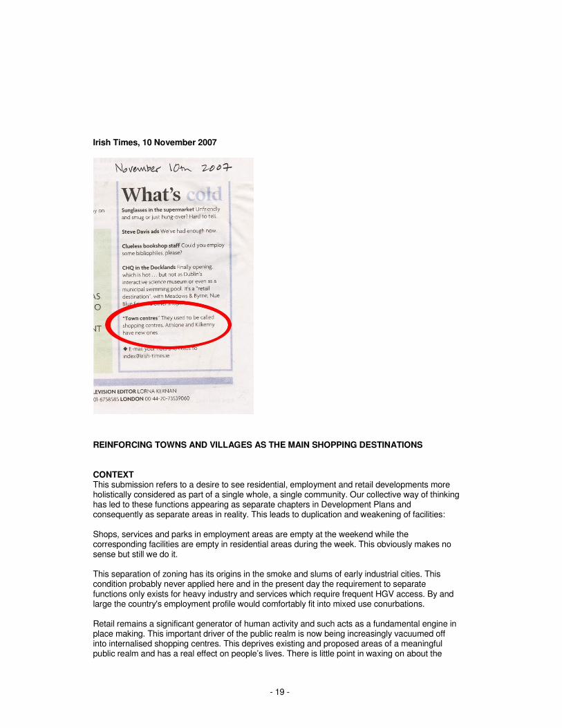
Irish Times, 10 November 2007
REINFORCING TOWNS AND VILLAGES AS THE MAIN SHOPPING DESTINATIONS CONTEXT This submission refers to a desire to see residential, employment and retail developments more holistically considered as part of a single whole, a single community. Our collective way of thinking has led to these functions appearing as separate chapters in Development Plans and consequently as separate areas in reality. This leads to duplication and weakening of facilities: Shops, services and parks in employment areas are empty at the weekend while the corresponding facilities are empty in residential areas during the week. This obviously makes no sense but still we do it. This separation of zoning has its origins in the smoke and slums of early industrial cities. This condition probably never applied here and in the present day the requirement to separate functions only exists for heavy industry and services which require frequent HGV access. By and large the country's employment profile would comfortably fit into mixed use conurbations. Retail remains a significant generator of human activity and such acts as a fundamental engine in place making. This important driver of the public realm is now being increasingly vacuumed off into internalised shopping centres. This deprives existing and proposed areas of a meaningful public realm and has a real effect on people’s lives. There is little point in waxing on about the
- 20 -
merits of mixed use and traditional towns in one paragraph and permitting isolated mono uses in the next. The focus of current policy is to increase the quality of the places we are creating. This focus recognises the fact that people experience urban areas emotionally and psychologically and hence place making should be a leading design policy in urban planning. There is currently recognition of the need to create sustainable places, where land use and transportation planning are considered in tandem and where urban design is to the forefront of planning. 'TOWN' DEFINITION The Department of Environment Heritage & Local Government's 'Retail Planning Guidelines for Planning Authorities' (January 2005) state: "The town centre is the focus for a range of commercial and community activities, resulting in a mix of, often interdependent, land uses which contribute to a sense of place and identity. It includes a combination of natural features: historic buildings, cultural, civic and governmental buildings, as well as public spaces. This physical form and mix of functions, which will have evolved over a considerable period of time, makes a town centre different from a shopping centre and provides much of its character which can be further enhanced by introducing appropriate new uses into historic buildings. It also has a high level of accessibility to employment, services, and facilities for all the community. These national guidelines also states that: "Shopping provision is a key component of town centres, and makes a major contribution to their vitality and viability” Section 7.3 of the draft Fingal Development Plan deals with town and district centres. We note the inclusion of a definition of 'successful urban centres' It is welcome that this definition recognises the importance of accommodating a broader range of mixed commercial, civic and residential uses in sustaining urban centres i.e. not simply retail. Furthermore we welcome the recognition of key urban design matters such as attractive townscape, streets and public spaces and the need to create of a sense of local identity and character. However in referring to 'urban centres', including Blanchardstown Town centre and Charlestown which are recognised elsewhere in the draft plan as shopping centres, we feel this definition is not clear enough in defining 'town centres' as opposed to 'shopping centres'. Shopping centres do not function as towns. Rather, it is the clustering of services in a public domain that makes a “Town”; and makes the Town the social focus of an area. The legacy of the previous Retail Strategy for the GDA was a second tier of “Towns”, two of which were actually towns and six were shopping centres. Under the category Level 2 Major Town Centres, eight metropolitan centres were designated. These centres serve populations more significant than many county towns and should provide a sense of place and identity for the areas they serve. Most of these 'town and district centres' are in fact shopping centres incl. in Fingal: BLANCHARDSTOWN TOWN CENTRE The draft development plan Retail Strategy clearly defines Blanchardstown Town Centre: as “a shopping centre surrounded by a number of retail parks.” The core retail area map on page 86 confirms this in stark graphic terms. This is not a town. It is located adjacent to a national route. It has no urban form, is surrounded by busy roads, and does not connect well with the surrounds. It does not comply with the key objectives.
- 21 -
SWORDS TOWN CENTRE The core retail centre of Swords is identified as comprising two different types of shopping environments: firstly the ‘frontages from Bridge Street/Chapel Lane along Main Street and to the Malahide Road and secondly the internalised Sword Pavilions shopping centre. Unfortunately the presence of an attached internalised mall has been to the detriment of Swords Main street CHARLSTOWN This is on Fingal's newest urban areas. Retail is provided in an internalised mall. This is not a town. INADEQUACY OF SHOPPING CENTRES Shopping centres are substandard places. They do not cater to the full population. Shopping centres are privatised spaces, they are not public spaces. Shopping centres are open at certain hours and on certain days, they are monitored and access can be controlled or deprived to certain groups. Towns are open, public spaces and are accessible to all. Towns should foster identity for the population they serve; they are the focus of public and civic life. Shopping centres are not attractive to all segments of the population. The elderly in particular are often intimidated by the scale and form of large shopping centres. Shopping centres are often surrounded by large surface car parks or else underground car parks, navigating through these can often be intimidating to the older person. This demographic do not want shopping centres to replace towns. It is very important to remember that the public realm, in which retail is located, satisfies important psychological needs. Jan Gehl, one of the most influential of current urban design theorists, maintains the importance of outdoor public space to the individual. He maintains that contact, stimulation and knowledge are three human needs that the public realm can serve. Contact is considered the most fundamental human need as it sub-consciously contributes to human well-being. Even the most basic form of contact, simply being present in a public space observing rather than inter-acting, is of huge psychological benefit. Humans are social animals and require frequent contact with other members of society. Shopping is arguably the most common reason why people are present in public spaces. It is vitally important therefore that shopping is not taken out of the public setting in which it has been located for the past millennia. The propensity for internalised privatised shopping centres over the last 50 years is sub-consciously privatising society because it is determining the environment in which society locates itself spatially. In the age of shopping-online that we now live in, this issue can only worsen. Internal spaces of shopping centres, although trafficked by the general public, simply cannot be classified as public spaces because they lack the uncontrolled neutrality of civic streets and squares. The increased privatisation of daily life through the car and the internet decreases the amount of time that people are present in a public environment. Locating shopping in a semi-private environment will not help the overall well-being of society. NEW COMMUNITIES, EXISTING COMMUNITIES & RETAIL PROVISION All new residential communities should have access to a full range of services including retail. However we would like to point out that the qualitative reasons for providing retail to serve new populations are equally as important as the quantitative reasons. A new or emerging area however should never be deprived of having proper facilities in order to support an ailing “town centre”, when it is, as often as not, a local shopping centre of no civic quality whatsoever. It is important to also consider that there are extensive areas of Dublin, already built, which do not meet the aspirations outlined above. Typically, these are suburbs from the sixties to nineties with population decline now occurring and local services at risk. Such population decline often occurs in areas of uniform two storey family housing where empty nesters choose to stay in their homes as there is no suitable alternative in the immediate area where their social connections are established. Such people would often happily gravitate towards their local centre where everything is walkable, if such a place existed at all.
- 22 -
A positive contribution to population stabilisation and service enhancement would be to actively support mixed use regeneration of existing mono use shopping centres in an effort to make them more of a civic centre for the areas they serve, and thus an attractive and familiar place to move to. This is to actively decommission internalised shopping centres and release retail as an engine contributing to the public realm. THE FUTURE OF BLANCHARDSTOWN AND SWORDS? While highlighting the failings of shopping centre, we do however welcome the recognition contained in the draft development plan retail strategy that the existing ‘components’ comprising Blanchardstown Town Centre “need cohesion, linkage and enhanced urban density connecting to the wider Blanchardstown area.” Similarly we welcome recognition that the challenge facing Swords Town Centre is to “serve the growing population of Swords and its catchment by encouraging growth in the area of comparison shopping and the attraction of retail multiples, while also addressing the impact of this on the traditional Main Street of the town.” These aspiration for the future development of Blanchardstown and Swords are supported by objective in the drat development plans Objective UC07 Implement the long term Masterplans prepared for the town centres of Swords and Blanchardstown. Retail Objective 2 Strengthen the role and vibrancy of Main Street in accordance with the Swords Masterplan and 2008-2020. While it would have been far more desirable if the development of Blanchardstown and Swords had not resulted in the creation of large internalised shopping centres we nonetheless welcome the aspiration and objectives contained in the draft plan for these two areas SUPPPORTING REAL TOWN CENTRES Both the guiding principles and the 21 objectives contained in the draft development plan retail strategy focus on location, scale, quantum and accessibility of retail provision. There is however no clear vision for the qualitative nature of retail centres. The key purpose of this submission is to propose that new retail provision should be focussed on real town centres, not shopping centres. County Development Plans can be used as positive tools to redress existing imbalances in the type and form of current retail & employment provision. There should be provision for biasing real “Towns” over shopping centres and office parks. The assessment of planning applications for new retail provision should not only be assessed with reference to the technical and quantitives aspects of the retail strategy but also to qualitative matters such as vibrancy of proposed urban environment and the impact on traditional town centres. The RIAI submit that it is of critical importance that in considering proposals for provision of new retail, planning authorities such as Fingal County Council should be in a position to refer to and accord with detailed area-based masterplans. Qualitative criteria should be included to reinforce a hierarchy of mixed-use places, written by suitably qualified personnel. Such criteria should include connectedness, location at the confluence of routes, accessibility particularly with regard public transport, a mix of uses, integrating employment and residential uses, provision of public streets and civic spaces to make a place identifiable to its population. Shopping uses accessed from internalised malls should be actively discouraged and should only ever form a small percentage of the available offer in a town. Internalised space should only be allowed grow as the town grows. It should never be allowed to subsume a town and effectively thwart its development as in Swords or exist in isolation as at Blanchardstown.
- 23 -
As stated already section 7.3 of the Draft Development Plan refers to 'urban centres', including Blanchardstown Town Centre which the Retail Strategy clearly defines as “a shopping centre surrounded by a number of retail parks.” The RIAI submit that all ‘double speak’ should be removed from the Development Plan. A town is a town. A shopping centre is not. The use of the word ‘centre’ on its own with the attendant deliberate ambiguity should be avoided. “Town Centre” should not be used as a euphemism for shopping centre and the Development Plan should avoid such ambiguity. Just as the term 'town' has been misappropriated to justify development, internalised shopping centres are increasingly being described in misappropriated urban design terminology. Internalised malls are not streets and atriums are not civic squares. Streets and squares are public spaces in a way that internalised / covered / sheltered, or how ever described, malls will never be. To fudge this issue is to completely misunderstand the meaning and significance of the public realm and to further feed the privatisation and corporate control of how people present and behave in public. The re-designation of shopping centres as post rationalised “town centres” under the GDA Retail Planning Strategy allowed these shopping centres to continue to expand to the detriment of real town centres i.e. urban settlements with street buildings in a traditional urban format. Out-of-town shopping centres should not be allowed to be the basis for retail provision for new populations around Dublin. Existing town centres should be strengthened and connections made and new real town centres should be created around civic spaces and attractive public realm. In summary the RIAI submit that the new Fingal Development Plan should contain a clear vision statement recognising the importance of existing real town centres and outlining how future retail provision can be accommodated in newly created town centres and as such should contain strategic recommendations which require:
• All retail and employment to be set in a mixed use context.
• Strong preference is given to retail and employment along public streets.
• Recognise retail as one of the strongest engines driving the assembly of people into public places. Harness this energy to give footfall, sense of place and legibility to neighbourhoods and districts, all in proportion to the order of service provided.
• Avoid shopping conglomerations under single management that may encourage the proliferation of restrictive or exclusive practices.
• Avoid mono-zoned ‘employment’ areas;
• Avoid using of the title “Town Centre” as a euphemism for shopping centre - the Development Plan should avoid any ambiguity;
• All proposals for new retail should not only be assessed with reference to the technical and quantitive aspects of the retail strategy but also with reference to qualitative matters such as vibrancy of proposed urban environment and the impact on traditional town centres.
- 24 -
Appendix A The RIAI CHECKLIST FOR SUSTAINABLE BUILDINGS William Scott, Chairman of the RIAI Sustainability Task Force Introduction It is often tempting to evaluate the “sustainability” of a building solely in terms of a single feature, perhaps the Building Energy Rating (BER) or use of particularly eco-friendly materials. BER can provide an excellent indicator of the theoretical energy performance of a building in use. The selection of appropriate materials is obviously desirable. However evaluation on such simplistic bases ignores many other aspects that are critical to a proper evaluation of the sustainability of a building. A building should respond to the three classic demands of sustainability; social, environmental and economic. If a building fails to pass scrutiny in one of these areas, it is unlikely that it is a truly sustainable building. The RIAI Sustainability Task Force (STF) is responsible for the assessment of submitted projects for the annual RIAI Sustainability Award. In 2007 that assessment was based on an objective checklist of criteria. The checklist has since been developed to also become a useful tool for designers when they evaluate their brief and develop a design. For this reason the checklist is now being made generally available to facilitate the design and construction of every building. It is hoped that this article will assist this process. The Need for a Checklist for Sustainable Buildings There is a range of systems available for evaluation of buildings, often most suited to a particular sector of building types; BREEAM, LEED, Ecohomes, BER and the like. These systems give an excellent response to various ranges of indicators. There is usually a significant expense and a very considerable effort involved in such assessments. At the other extreme, all architects have seen buildings being hailed as “green”, in a manner that may be scarcely credible, with no obvious basis to support such claims. Most practitioners will welcome the availability of a free, quick and relatively simple checklist that enables a preliminary evaluation of the sustainability of a building. A subsequent in-depth assessment will of course be appropriate in many cases, meriting the expense and effort involved in a formal evaluation of the type mentioned. The evaluation of an architectural competition on sustainability of buildings must be completed as objectively and comprehensively as is possible. Availability of a checklist allows a simple, quick and consistent evaluation of entries for the RIAI Sustainability Award. The Origin of the Checklist Bill Gething and Bill Bordass published an article in 2006 describing a Rapid Assessment Checklist for Sustainable Buildings. The article describes the development of the checklist, drawing from earlier evaluation systems and from original research, and its use in the RIBA Sustainability Award in 2005. Sally Starbuck of RIAI STF approached the authors and the RIBA and gained their generous permission to utilise and adapt the work to suit the purposes of RIAI. Where such modifications have taken place, the STF has attempted to maintain the core principle of using the checklist to enable a broad range of evaluation with consistency, simplicity and clarity of use. The resulting Checklist for Sustainable Buildings is now published on the RIAI website.
- 25 -
Exploring the checklist The checklist places the assessment topics in 11 main groupings, which are considered under headings appropriate to the design and construction process. The topics are listed with some brief comments. The CONTEXT section considers the Choice of the site, which will have a significant effect on the immediate and lifelong environmental impact of the building. Constant expansion of the built environment is obviously ultimately unsustainable. Buildings that are remote from central resources carry large and continuing burdens associated with transport and servicing. However, decisions about the choice of site are not always within the control of the architect. The DESIGN CHOICES section considers matters that generally fall within the control of the architect. The key issues considered are the Use of the site (dealing with the effect on the immediate site and surroundings of the building and its usage), Building form (dealing with the key issues relating to the shape and location of the building) and Use of materials. The OUTCOMES section considers the results of the decisions of the architect and their team. The checklist occasionally requires a record of the normal or benchmark standards for a building type (as well as the source of that benchmark) as well as the design or target standard achieved (and the source / verification of the data). Key issues examined are the Functionality or useability of the building as well as the Indoor environment achieved. Energy, CO2 and utilities are considered in some detail in this very critical area of performance. Specific objective information is required concerning primary and delivered energy usage for the building. Much of this information will be available from a standard BER assessment or from specialist modelling of large buildings. The last part of this section deals with Emissions of all kinds from the building. The DESIGN AND CONSTRUCTION PROCESS section considers a range of issues, some of which merit description. Briefing and Design Reviews: Sustainability deals with the appropriate and timely consideration of sustainability throughout the process. Considerate Constructor is a concept that may be unfamiliar to many in Ireland. It derives from a UK code of behaviour for builders and aims to reduce negative impact of construction operations on the environment, the public and the workforce. Participation by a builder also gains points during BREEAM assessment. In the Irish context, and hopefully pending the development of such a local scheme, the response must relate to the deliberate and recorded response of a contractor to these issues. Incorporating Post Occupancy Evaluation (POE) involves the stated commitment to, or actual completion of, a POE to analyse the results achieved in a completed building and the response of building occupants and users over a broad range of issues. The section ACHIEVED PERFORMANCE will only be used for buildings that are in use long enough to yield useful results. Where this is the case, as-built results (as opposed to design or intended) should be utilised in some of the earlier sections of the checklist, with a declaration to this effect in this section. A SUPPLEMENTARY NOTES section allows the addition of relevant information which the checklist has not explored. Finally, the RIAI seeks a response to the checklist from members and invites comment in a Feedback section on the forms submitted for the competition. Use of the Checklist The checklist form is filled out as follows: - Enter the title of the building. - Describe your response to each criterion. If the criterion is not appropriate to the project, state why. - Apply your own numerical rating to the criterion ... -2 to +3 as appropriate. Guidelines to numerical ratings are described on the form.
- 26 -
- Enter the standard performance benchmarks and the performance as targeted or as actually achieved (where appropriate). - Identify the source of all data. - Add supplementary comments at the foot of the sheet and attach relevant material. Where the procedure is carried out by the architect for their own use, it will be useful to refer to the checklist through the brief and design stages. A record should normally be retained. Where the checklist is used as (an essential) part of the competition for the RIAI Sustainability Award, it should be submitted as a part of the competition documentation. Competitors are asked to use the checklist to “self-assess”. The competition jury will use the submitted checklist as a source of - information leading to understanding of design strategies and concepts, - factual information that might not otherwise be apparent from presentation documents, - hard performance data in a format that enables fair comparison. The process of evaluation of the RIAI Sustainability Award is carried out in the following manner: - Blank checklists are used by each jury member, who independently evaluates buildings based on submitted information. - Assessments are coordinated to compile a shortlist. - The shortlisted projects are then evaluated jointly by the jury. - An award winner is selected and the award citation for the project is agreed. It is recognised that individual topics on the checklist will be of greater or lesser significance in various buildings. In some cases, a response may not be appropriate; this should be stated. For this reason, there is no attempt to apply a weighting to any topic. “Marks” will not be “added up”. Instead, individual numerical and written responses will be considered in the context of the particular building, leading to an overall opinion on the sustainability of the building.
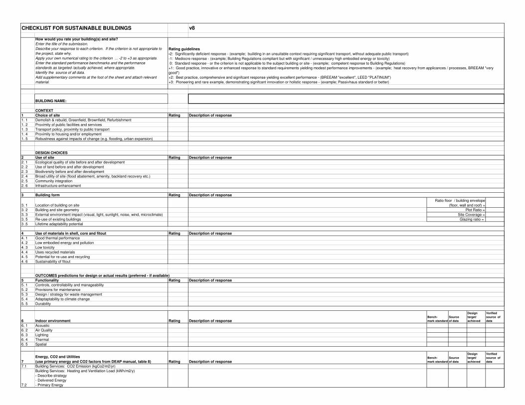
CHECKLIST FOR SUSTAINABLE BUILDINGS
How would you rate your building(s) and site?
Enter the title of the submission.
Describe your response to each criterion. If the criterion is not appropriate to
the project, state why.
Apply your own numerical rating to the criterion ... -2 to +3 as appropriate.
Enter the standard performance benchmarks and the performance
standards as targeted /actually achieved, where appropriate.
Identify the source of all data.
Add supplementary comments at the foot of the sheet and attach relevant
material.
BUILDING NAME:
CONTEXT
1 Choice of site Rating
1. 1 Demolish & rebuild, Greenfield, Brownfield, Refurbishment
1. 2 Proximity of public facilities and services
1. 3 Transport policy, proximity to public transport
1. 4 Proximity to housing and/or employment
1. 5 Robustness against impacts of change (e.g. flooding, urban expansion)
DESIGN CHOICES
2 Use of site Rating
2. 1 Ecological quality of site before and after development
2. 2 Use of land before and after development
2. 3 Biodiversity before and after development
2. 4 Broad utility of site (flood abatement, amenity, backland recovery etc.)
2. 5 Community integration
2. 6 Infrastructure enhancement
3 Building form Rating
3. 1 Location of building on site
3. 2 Building and site geometry
3. 3 External environment impact (visual, light, sunlight, noise, wind, microclimate)
3. 5 Re-use of existing buildings
3 .5 Lifetime adaptability potential
4 Use of materials in shell, core and fitout Rating
4. 1 Good thermal performance
4. 2 Low embodied energy and pollution
4. 3 Low toxicity
4. 4 Uses recycled materials
4. 5 Potential for re-use and recycling
4. 6 Sustainability of fitout
OUTCOMES predictions for design or actual results (preferred - if available)
5 Functionality Rating
5. 1 Controls, controllability and manageability
5. 2 Provisions for maintenance
5. 3 Design / strategy for waste management
5. 4 Adaptaptability to climate change
5. 5 Durability
6 Indoor environment Rating Description of responseBench-
mark standard
Source
of data
Design
target/
achieved
Verified
source of
data
6. 1 Acoustic
6. 2 Air Quality
6. 3 Lighting
6. 4 Thermal
6. 5 Spatial
7
Energy, CO2 and Utilities
(use primary energy and CO2 factors from DEAP manual, table 8) Rating Description of responseBench-
mark standard
Source
of data
Design
target/
achieved
Verified
source of
data
7.1 Building Services: CO2 Emission (kgCo2/m2/yr)
7.2
Building Services: Heating and Ventilation Load (kWh/m2/y)
- Describe strategy
- Delivered Energy
- Primary Energy
Description of response
Ratio floor / building envelope
(floor, wall and roof) =
Plot Ratio =
Site Coverage =
v8
Rating guidelines
-2: Significantly deficient response - (example; buiilding in an unsuitable context requiring significant transport, without adequate public transport)
-1: Mediocre response - (example; Building Regulations compliant but with significant / unnecessary high embodied energy or toxicity)
0: Standard response - or the criterion is not applicable to the subject building or site - (example; competent response to Building Regulations)
+1: Good practice, innovative or enhanced response to standard requirements yielding modest performance improvements - (example; heat recovery from applicances / processes, BREEAM "very
good")
+2: Best practice, comprehensive and signifcant response yielding excellent performance - (BREEAM "excellent", LEED "PLATINUM")
+3: Pioneering and rare example, demonstrating signifcant innovation or holistic response - (example; Passivhaus standard or better)
Description of response
Description of response
Description of response
Description of response
Glazing ratio =
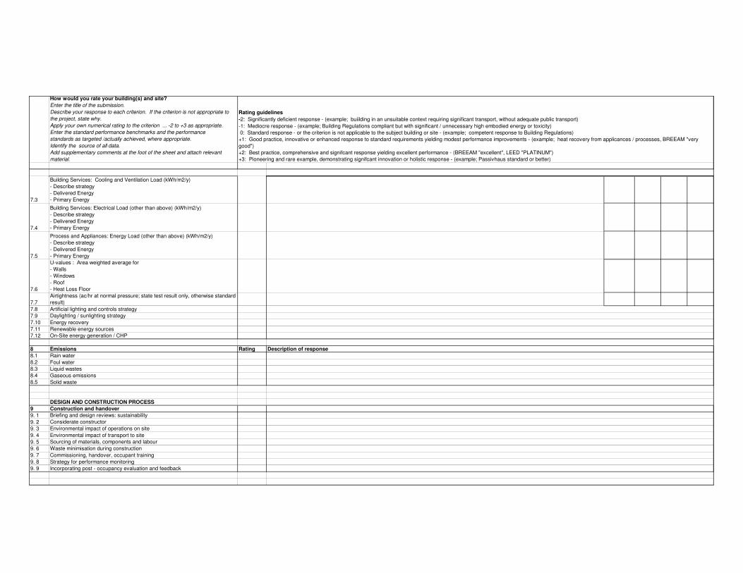
How would you rate your building(s) and site?
Enter the title of the submission.
Describe your response to each criterion. If the criterion is not appropriate to
the project, state why.
Apply your own numerical rating to the criterion ... -2 to +3 as appropriate.
Enter the standard performance benchmarks and the performance
standards as targeted /actually achieved, where appropriate.
Identify the source of all data.
Add supplementary comments at the foot of the sheet and attach relevant
material.
Rating guidelines
-2: Significantly deficient response - (example; buiilding in an unsuitable context requiring significant transport, without adequate public transport)
-1: Mediocre response - (example; Building Regulations compliant but with significant / unnecessary high embodied energy or toxicity)
0: Standard response - or the criterion is not applicable to the subject building or site - (example; competent response to Building Regulations)
+1: Good practice, innovative or enhanced response to standard requirements yielding modest performance improvements - (example; heat recovery from applicances / processes, BREEAM "very
good")
+2: Best practice, comprehensive and signifcant response yielding excellent performance - (BREEAM "excellent", LEED "PLATINUM")
+3: Pioneering and rare example, demonstrating signifcant innovation or holistic response - (example; Passivhaus standard or better)
7.3
Building Services: Cooling and Ventilation Load (kWh/m2/y)
- Describe strategy
- Delivered Energy
- Primary Energy
7.4
Building Services: Electrical Load (other than above) (kWh/m2/y)
- Describe strategy
- Delivered Energy
- Primary Energy
7.5
Process and Appliances: Energy Load (other than above) (kWh/m2/y)
- Describe strategy
- Delivered Energy
- Primary Energy
7.6
U-values : Area weighted average for
- Walls
- Windows
- Roof
- Heat Loss Floor
7.7
Airtightness (ac/hr at normal pressure; state test result only, otherwise standard
result)
7.8 Artificial lighting and controls strategy
7.9 Daylighting / sunlighting strategy
7.10 Energy recovery
7.11 Renewable energy sources
7.12 On-Site energy generation / CHP
8 Emissions Rating
8.1 Rain water
8.2 Foul water
8.3 Liquid wastes
8.4 Gaseous emissions
8.5 Solid waste
DESIGN AND CONSTRUCTION PROCESS
9 Construction and handover
9. 1 Briefing and design reviews: sustainability
9. 2 Considerate constructor
9. 3 Environmental impact of operations on site
9. 4 Environmental impact of transport to site
9. 5 Sourcing of materials, components and labour
9. 6 Waste minimisation during construction
9. 7 Commissioning, handover, occupant training
9. 8 Strategy for performance monitoring
9. 9 Incorporating post - occupancy evaluation and feedback
Description of response
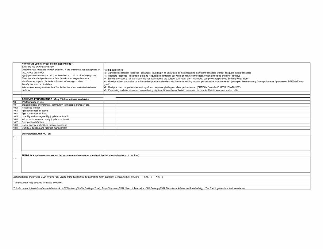
How would you rate your building(s) and site?
Enter the title of the submission.
Describe your response to each criterion. If the criterion is not appropriate to
the project, state why.
Apply your own numerical rating to the criterion ... -2 to +3 as appropriate.
Enter the standard performance benchmarks and the performance
standards as targeted /actually achieved, where appropriate.
Identify the source of all data.
Add supplementary comments at the foot of the sheet and attach relevant
material.
Rating guidelines
-2: Significantly deficient response - (example; buiilding in an unsuitable context requiring significant transport, without adequate public transport)
-1: Mediocre response - (example; Building Regulations compliant but with significant / unnecessary high embodied energy or toxicity)
0: Standard response - or the criterion is not applicable to the subject building or site - (example; competent response to Building Regulations)
+1: Good practice, innovative or enhanced response to standard requirements yielding modest performance improvements - (example; heat recovery from applicances / processes, BREEAM "very
good")
+2: Best practice, comprehensive and signifcant response yielding excellent performance - (BREEAM "excellent", LEED "PLATINUM")
+3: Pioneering and rare example, demonstrating signifcant innovation or holistic response - (example; Passivhaus standard or better)
ACHIEVED PERFORMANCE ( Only if information is available )
10 Performance in use
10.1 Impact on local environment, community, townscape, transport etc.
10.2 Response to brief
10.3 Appropriateness of space
10.4 Appropriateness of fitout
10.5 Usability and manageability (update section 5)
10.6 Indoor environmental quality (update section 6)
10.7 Occupant satisfaction
10.8 Use of energy and utilities (update section 7)
10.9 Quality of building and facilities management
SUPPLEMENTARY NOTES
11
12
This document is based on the published work of Bill Bordass (Usable Buildings Trust), Tony Chapman (RIBA Head of Awards) and Bill Gething (RIBA President's Adviser on Sustainability). The RIAI is grateful for their assistance.
FEEDBACK - please comment on the structure and content of the checklist (for the assistsance of the RIAI)
Actual data for energy and CO2 for one year usage of the building will be submitted when available, if requested by the RIAI. Yes ( ) No ( )
This document may be used for public exhibition.