REVISION: Revision No. 1; October 9, 2015 - NASA · PDF fileinstrument capabilities,...
14
Revision No. 1 to the FY16 ASP Call Letter was issued on Oct 9, 2015. Revisions to original are in red. May 10, 2017 TO: Distribution FROM: Earth Science Division, Airborne Science Program Director SUBJECT: FY 2017 Airborne Science Flight Program REVISION: Revision No. 1; October 9, 2015 The Airborne Science Program (ASP) under the Earth Science Division (ESD) of the Science Mission Directorate (SMD) announces the annual call for Fiscal Year 2017 Flight Requests. This call applies to Earth Science activities anticipated to occur between October 2016 and September 2017 that will utilize ASP core aircraft, facility instruments, ASP science support assets or any ESD funded activities/missions using aircraft or personnel (see appendix A for definitions and SOFRS requirement decision tree). Consult this document for updated summary information concerning instrumentation, aircraft/platform flight hour costs, Points of Contact (POC) and general Flight Request (FR) information. Detailed and continually updated aircraft and instrument information can be found on the Airborne Science Program website (https://airbornescience.nasa.gov). This site is a centralized portal for all program components, including the Science Operations Flight Request System (SOFRS), platforms, instrument capabilities, schedules, and POC information. SOFRS can be accessed directly at https://airbornescience.nasa.gov/sofrs/. In addition, investigators in the pre-proposal planning stage may contact Randy Albertson (661-276-7540) or Matt Fladeland (650-604-3325) for platform selection, integration, feasibility study, or early engineering support. PLEASE NOTE: All missions utilizing NASA instruments, personnel, aircraft or funds must be in compliance with the NASA Aircraft Operations Management Manual (NPR 7900.3C). User Fees All airborne assets (aircraft and instruments) are subject to user fees. These fees reflect the usage cost and are assessed by the organization operating the asset. This is true for both NASA and non-NASA assets. A Flight Request (FR) is required for scheduling usage of an ASP core aircraft, a facility instrument, and/or an ASP science support asset through SOFRS. Flight Requests should be associated with a NASA program, grant, proposal, or, if funded from a non-NASA source, deemed to be directly related to a NASA area of interest. If no NASA investigation is associated with the request, it will be handled as a Reimbursable Mission and may be required to include justification for use of NASA facilities and possibly subject to additional fees. For non-NASA/Earth Science Division funded FRs to be considered for the subsidized rate, please include the name and contact information of a NASA sponsor (NASA HQ Science Concurrence) who National Aeronautics and Space Administration Headquarters Washington, DC 20546-0001
Transcript of REVISION: Revision No. 1; October 9, 2015 - NASA · PDF fileinstrument capabilities,...

Revision No. 1 to the FY16 ASP Call Letter was issued on Oct 9, 2015. Revisions to original are in red.
May 10, 2017 TO: Distribution FROM: Earth Science Division, Airborne Science Program Director SUBJECT: FY 2017 Airborne Science Flight Program REVISION: Revision No. 1; October 9, 2015 The Airborne Science Program (ASP) under the Earth Science Division (ESD) of the Science Mission Directorate (SMD) announces the annual call for Fiscal Year 2017 Flight Requests. This call applies to Earth Science activities anticipated to occur between October 2016 and September 2017 that will utilize ASP core aircraft, facility instruments, ASP science support assets or any ESD funded activities/missions using aircraft or personnel (see appendix A for definitions and SOFRS requirement decision tree). Consult this document for updated summary information concerning instrumentation, aircraft/platform flight hour costs, Points of Contact (POC) and general Flight Request (FR) information. Detailed and continually updated aircraft and instrument information can be found on the Airborne Science Program website (https://airbornescience.nasa.gov). This site is a centralized portal for all program components, including the Science Operations Flight Request System (SOFRS), platforms, instrument capabilities, schedules, and POC information. SOFRS can be accessed directly at https://airbornescience.nasa.gov/sofrs/. In addition, investigators in the pre-proposal planning stage may contact Randy Albertson (661-276-7540) or Matt Fladeland (650-604-3325) for platform selection, integration, feasibility study, or early engineering support. PLEASE NOTE: All missions utilizing NASA instruments, personnel, aircraft or funds must be in compliance with the NASA Aircraft Operations Management Manual (NPR 7900.3C). User Fees All airborne assets (aircraft and instruments) are subject to user fees. These fees reflect the usage cost and are assessed by the organization operating the asset. This is true for both NASA and non-NASA assets. A Flight Request (FR) is required for scheduling usage of an ASP core aircraft, a facility instrument, and/or an ASP science support asset through SOFRS. Flight Requests should be associated with a NASA program, grant, proposal, or, if funded from a non-NASA source, deemed to be directly related to a NASA area of interest. If no NASA investigation is associated with the request, it will be handled as a Reimbursable Mission and may be required to include justification for use of NASA facilities and possibly subject to additional fees. For non-NASA/Earth Science Division funded FRs to be considered for the subsidized rate, please include the name and contact information of a NASA sponsor (NASA HQ Science Concurrence) who
National Aeronautics and Space Administration Headquarters Washington, DC 20546-0001

2017 Call Letter Airborne Science Program
Revision No. 1 to the FY16 ASP Call Letter was issued on Oct 9, 2015. Revisions to original are in red. 2
has agreed to deem the research to be directly related to a NASA Earth science area of interest as well as the name and contact information for the Funding Source. Once a Flight Request is approved and scheduled, the user fees must be forwarded to the performing organization(s). In most cases, user fees must be available to the performing center(s) before mission activities, such as integration, can occur. For SMD funded researchers using NASA assets, the fees will normally be withheld from the investigator’s budget and sent by the sponsor directly to the NASA aircraft or instrument organization. For researchers using non-NASA assets, the fee payment process will vary and the Airborne Science business managers at each center are prepared to assist the investigator with the financial procedures. Integration and Mission Peculiar Costs In addition to user fees, integration costs (aircraft and instrument dependent) and Mission Peculiar Costs (MPCs) may be applied to the FR budget by the aircraft manager. Detailed information on MPCs, including satellite communication (SATCOM) MPC’s, along with integration costs is located in Appendix B. All relevant MPCs should be discussed with the aircraft manager. ROSES, EOS and Multi-Aircraft Missions Anyone, including ESD funded investigators with approved or pending proposals from Research Opportunities in Space and Earth Sciences (ROSES) announcements, with a requirement for an Airborne Science Program (ASP) core aircraft, facility instrument, and/or science support asset is required to submit a Flight Request. The Flight Request is also the method to acquire a cost estimate for inclusion in proposals, but is not a substitute for a proposal. FR and user fee information for Earth Observing System (EOS) Investigators can be found in Appendix C. Please note, for investigators proposing to participate on large, multi-aircraft experiments, such as the ROSES Call 2015: KORUS-AQ (Korea US- Air Quality), a single Flight Request will be submitted for each mission by the Project Manager or Project Scientist. ASP Supported and Other NASA Aircraft The Airborne Science Program continues to support an inventory of unique highly modified “science-ready” platforms, as well as coordinate access to other NASA aircraft. See Appendix D for the list of current flight hour costs and https://airbornescience.nasa.gov/aircraft for a detailed list of available aircraft. Federal and Commercial Aircraft NASA instrumentation may fly on non-NASA Federal aircraft as well as academic and commercial platforms for which agreements for access by SMD investigators are in place, in process, or have recently been approved by NASA Aviation Management as airworthy and safe to operate. For non-NASA aircraft, proposals need to include costs associated with NASA safety reviews, which may include travel to off site facilities. Investigators are responsible for contacting the relevant parties to determine if the platform meets the requirements of the proposed scientific investigation. As reference, the ASP website includes Commercial Aircraft recently used by NASA for science research. NASA does not endorse any commercial product or organization, and other comparable systems may exist within the industry. NASA is not responsible for maintaining or verifying the accuracy of data on non-NASA web sites. Before any actual data collection flights utilizing NASA personnel, property or funds, all vendors are subject to airworthiness/flight safety reviews in accordance with NASA Procedural Requirements in 7900.3C.
2017 Call Letter Airborne Science Program
Revision No. 1 to the FY16 ASP Call Letter was issued on Oct 9, 2015. Revisions to original are in red. 3
Facility Instruments Several remote sensing systems are considered as NASA facility instruments, in part because they support multiple science disciplines, and a variety of NASA science objectives. They are supported by managers in the ESD Research and Analysis program, and/or the EOS Project Science Office, and are made available to the wider NASA science community via the Flight Request process. When using a facility instrument, an operations support team may or may not be required to deploy with the instrument. User Fees for the instrument team and data processing costs may be required in addition to aircraft Mission Peculiar Costs (MPC) and flight hour costs. Approval for use of a facility Instrument is granted by the sponsoring science Program Manager/Scientist. Appendix E shows available facility instruments with POC info. Appendix F lists Program Managers who make use of the ASP platforms. IMPORTANT: AVIRIS-Classic, eMAS, MASTER and UAVSAR investigators are requested to submit FY17 Flight Requests before September 30, 2016, to allow the ASP Program Managers, instrument teams and NASA Headquarters to plan appropriately for the upcoming flight season. Any Flight Requests received after September 30, 2016 may still be approved, but will be accommodated on a “best efforts” basis for FY17 or may be scheduled the following year. Flight Requests for US locations must be submitted at least 2 months before the desired collection dates, except in cases of rapid response missions to support hazard mapping. Flight Requests for non-US locations must be submitted at least 6 months prior to desired data collection dates. The Flight Request process is managed by the Earth Science Project Office (ESPO) at Ames Research Center. If you did not receive this message directly and would like to be included in further distributions, or if you have any questions regarding the Flight Request System or process please see the ASP Flight Request Procedures document and/or contact: Steven Todorov at: [email protected] or at 650-604-1296. Questions regarding the Airborne Science Program can be addressed to: Bruce Tagg or Randy Albertson Program Director Deputy Program Director [email protected] [email protected] Tel: 202-358-2890 Tel: 661-276-7540 Please submit your completed FY17 Flight Requests as soon in your planning process as possible. Sincerely, Bruce Tagg Director, Airborne Science Program Science Mission Directorate

2017 Call Letter Airborne Science Program
Revision No. 1 to the FY16 ASP Call Letter was issued on Oct 9, 2015. Revisions to original are in red. 4
Appendix A
What is the originof your funding?
Are you using an ASP Core Aircraft1,Facility Instrument2,or Science Support
Asset3?
Submit a Flight Request
in SOFRS?
Decision Tree for Filing a Flight Request in SOFRS
ESD
REQUIRED
REQUIREDNO
YES
Other NASA
OPTIONALNO
YES
NO
YES
Examples: SMD (Non-ESD), Center Funding, Other Mission Directorates
Non-NASAExamples:
Other Agencies, Industry Partners,
or Universities
DC-8ER-2P-3 OrionC-20A (G-III)Global Hawk
1ASP Core Aircraft 2Facility InstrumentsAVIRIS-CAVIRIS-NGMASTEReMAS UAVSARLVIS NAST-I
3ASP Science Support Assets
DMSPOS AV
OPTIONAL
REQUIRED
REQUIRED

2017 Call Letter Airborne Science Program
Revision No. 1 to the FY16 ASP Call Letter was issued on Oct 9, 2015. Revisions to original are in red. 5
Appendix B Budgeting for an Airborne Science Mission
Airborne Science Mission Costs In addition to the usage-based flight hour costs (personnel, fuel, and aircraft operations), additional MPCs, including those for SATCOM, Airborne Senor Facility (ASF) and NSERC (National Suborbital Education and Research Center (NSERC), and integration, may be included in the Flight Request cost estimate. Please discuss the applicability of any relevant costs with the aircraft lead. Aircraft Integration If an instrument has not yet flown on an aircraft or the instrument(s) require(s) significant effort to integrate into the aircraft, “integration fees” will be assessed. Aircraft MPCs MPCs include general deployment costs, overtime and personnel augmentation costs, and aircraft support costs. ASF and NSERC MPCs The Airborne Senor Facility (ASF) and NSERC (National Suborbital Education and Research Center (NSERC) support aircraft operations by providing instrumentation, operations, and engineering support. These services will be charged to relevant FRs as an MPC. Satellite Communication (SATCOM) MPCs Satellite communications systems of various types are now installed on most of the core science platforms. The tools referenced below are provided to assist in the development of requirements and for general SATCOM cost reference. After reviewing the SATCOM Requirements and Costing pages, in the PI Support section of the ASP home page investigators should discuss preliminary requirements with the aircraft lead. The relevant SATCOM lead will be responsible for creating the final estimate. Iridium sat-phone modems, with data rates up to 9.6Kb/sec, are standard equipment on the Global Hawk, DC-8, ER-2, C-130 and P-3 aircraft. These are included in the new NASDAT (NASA Airborne Science Data and Telemetry system) navigation data recorders. Payload use of the Iridium service through the NASDATs is available globally and is provided as part of the flight hour cost of the platform. INMARSAT BGAN (Broadband Global Area Network) airborne sat-com terminals supporting up to 432Kb/sec duplex data rates, are installed on the DC-8, the P-3, and both ER-2s. An INMARSAT Requirements document and preliminary estimating worksheet may be found at: https://airbornescience.nasa.gov/content/INMARSAT_Requirements_and_Estimating_Sheet The Global Hawk UAS and WB-57F include a Ku-band sat-com system (data rates in excess of 1Mb/sec) as standard mission equipment. Use of either BGAN or Ku systems are quoted as a SATCOM MPC to the Investigator in the FR. It should be noted that BGAN and Ku-Band service degrades rapidly at latitudes above ~70 degrees. Ku contracts are month long and vary based on coverage location and the current contract pricing. Sample Ku costs by region can be found at: https://airbornescience.nasa.gov/content/SATCOM_Requirements_and_Costing
2017 Call Letter Airborne Science Program
Revision No. 1 to the FY16 ASP Call Letter was issued on Oct 9, 2015. Revisions to original are in red. 6
Appendix C SPECIAL ADDENDUM FOR
EOS INVESTIGATORS PLANNING FOR NASA’S FY 2017
SCIENCE MISSION DIRECTORATE AIRBORNE SCIENCE PROGRAM
May 10, 2016
Introduction This addendum contains specific guidance for Earth Observing System (EOS) Investigators in responding to the ASP Annual Call Letter.
EOS investigators have responsibility for instrument support and maintenance, and each investigator should plan on paying the cost of aircraft operations. It must be recognized that there are many demands for aircraft support of other NASA satellite missions, the NASA Science Programs, and other users. Hence, it is not likely that all of the proposed aircraft missions can be accomplished. It is incumbent upon all investigators to plan carefully and combine missions with other investigators whenever possible.
Flight Request NASA is making the Annual Call Letter for the development of the FY 2017 Earth Science Division (ESD) Airborne Science Program plan available electronically at https://airbornescience.nasa.gov. Flight Requests should be submitted at https://airbornescience.nasa.gov/sofrs/.
EOS Team Members and Instrument Investigators should enter the following in the “Funding Source” box of the Flight Request form:
Dr. Steven Platnick EOS Senior Project Scientist NASA/Goddard Space Flight Center Mail Stop 610 Greenbelt, MD 20771 Phone: 301-614-5636 FAX: 301-614-5620 Internet: [email protected]
Similarly, Interdisciplinary Investigators should enter the following in the box:
(Discipline Manager) Earth Science Division Science Mission Directorate NASA Headquarters 300 E St. SW Washington, DC 20546

2017 Call Letter Airborne Science Program
Revision No. 1 to the FY16 ASP Call Letter was issued on Oct 9, 2015. Revisions to original are in red. 7
The EOS review of Flight Requests and setting of priorities will be accomplished by the EOS Senior Project Scientist and the Associate Director for Research for the Earth Science Division. To enable the most equitable allocation of available resources, you are asked to send a copy of your Flight Request to the Team Leader or Principal Investigator of your science team who will be called upon to help prioritize multiple requests from a single investigation team.
In FY 2017, as in previous years, aircraft flight hour costs have been instituted by the SMD Airborne Science Program (see Appendix D). Flight hour fees will be withheld automatically from each EOS investigator’s budget and transferred directly to the appropriate flight account at Armstrong, Wallops, Johnson, Langley, Glenn or appropriate contract for cooperative aircraft. However, the EOS Project Science Office will consider supporting up to 50% of EOS flight hour costs from a Special Aircraft Support Fund, subject to scientific priorities, programmatic balance, and availability of funds in FY 2017 with the remaining 50% or more coming from the individual investigator budgets. Depending upon the number and scope of the Flight Requests, the Special Aircraft Support Fund will also be used to pay Mission Peculiar Costs (MPC) in their entirety. The total amount available for both flight fees and MPC will be up to $300K in FY 2017.
In addition to flight hour costs, certain instrument operation and data production costs (“data fees”) have been instituted by the Science Mission Directorate. Data fees, if any, are the responsibility of each individual investigator and will not be subsidized by the Special Aircraft Support Fund in FY 2017. In some cases, investigators may be able to avoid overhead charges by their home institutions by having the government transfer data fees directly from their accounts to the appropriate data account at a NASA Center. An investigator should contact the appropriate Resource Analyst or Contracting Officer to make such arrangements. Data from many instruments, e.g., photography on most aircraft, are available at no cost or only nominal cost for approved flights.
Scheduling and final flight year approvals are the responsibility of:
Bruce Tagg Director, Airborne Science Program Earth Science Division Science Mission Directorate NASA Headquarters 300 E St. SW; Mail Suite: 3N71 Washington, DC 20546 Phone: 202-358-2890 Email: [email protected]
2017 Call Letter Airborne Science Program
Revision No. 1 to the FY16 ASP Call Letter was issued on Oct 9, 2015. Revisions to original are in red. 8
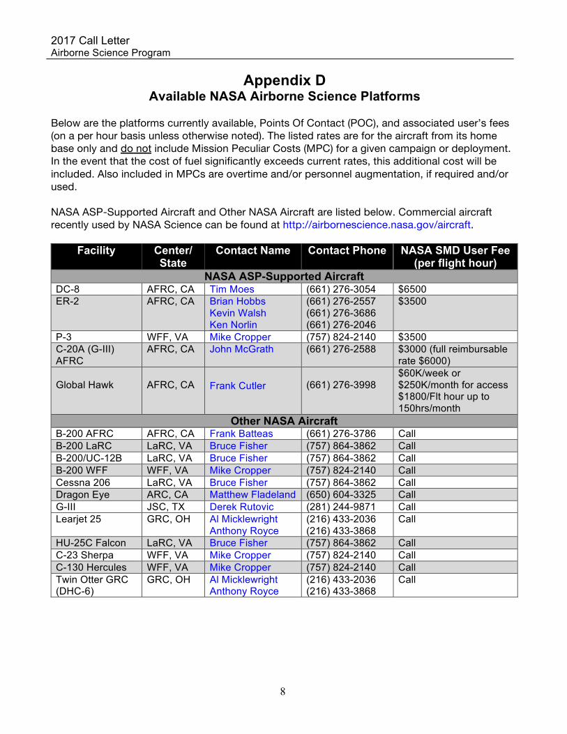
Appendix D Available NASA Airborne Science Platforms
Below are the platforms currently available, Points Of Contact (POC), and associated user’s fees (on a per hour basis unless otherwise noted). The listed rates are for the aircraft from its home base only and do not include Mission Peculiar Costs (MPC) for a given campaign or deployment. In the event that the cost of fuel significantly exceeds current rates, this additional cost will be included. Also included in MPCs are overtime and/or personnel augmentation, if required and/or used. NASA ASP-Supported Aircraft and Other NASA Aircraft are listed below. Commercial aircraft recently used by NASA Science can be found at http://airbornescience.nasa.gov/aircraft.
Facility Center/ State
Contact Name Contact Phone NASA SMD User Fee (per flight hour)
NASA ASP-Supported Aircraft DC-8 AFRC, CA Tim Moes (661) 276-3054 $6500 ER-2 AFRC, CA Brian Hobbs
Kevin Walsh Ken Norlin
(661) 276-2557 (661) 276-3686 (661) 276-2046
$3500
P-3 WFF, VA Mike Cropper (757) 824-2140 $3500 C-20A (G-III) AFRC
AFRC, CA John McGrath (661) 276-2588 $3000 (full reimbursable rate $6000)
Global Hawk
AFRC, CA
Frank Cutler
(661) 276-3998
$60K/week or $250K/month for access $1800/Flt hour up to 150hrs/month
Other NASA Aircraft B-200 AFRC AFRC, CA Frank Batteas (661) 276-3786 Call B-200 LaRC LaRC, VA Bruce Fisher (757) 864-3862 Call B-200/UC-12B LaRC, VA Bruce Fisher (757) 864-3862 Call B-200 WFF WFF, VA Mike Cropper (757) 824-2140 Call Cessna 206 LaRC, VA Bruce Fisher (757) 864-3862 Call Dragon Eye ARC, CA Matthew Fladeland (650) 604-3325 Call G-III JSC, TX Derek Rutovic (281) 244-9871 Call Learjet 25 GRC, OH Al Micklewright
Anthony Royce (216) 433-2036 (216) 433-3868
Call
HU-25C Falcon LaRC, VA Bruce Fisher (757) 864-3862 Call C-23 Sherpa WFF, VA Mike Cropper (757) 824-2140 Call C-130 Hercules WFF, VA Mike Cropper (757) 824-2140 Call Twin Otter GRC (DHC-6)
GRC, OH Al Micklewright Anthony Royce
(216) 433-2036 (216) 433-3868
Call
2017 Call Letter Airborne Science Program
Revision No. 1 to the FY16 ASP Call Letter was issued on Oct 9, 2015. Revisions to original are in red. 9
Facility Center/
State
Contact Name Contact Phone
NASA SMD User Fee (per flight hour)
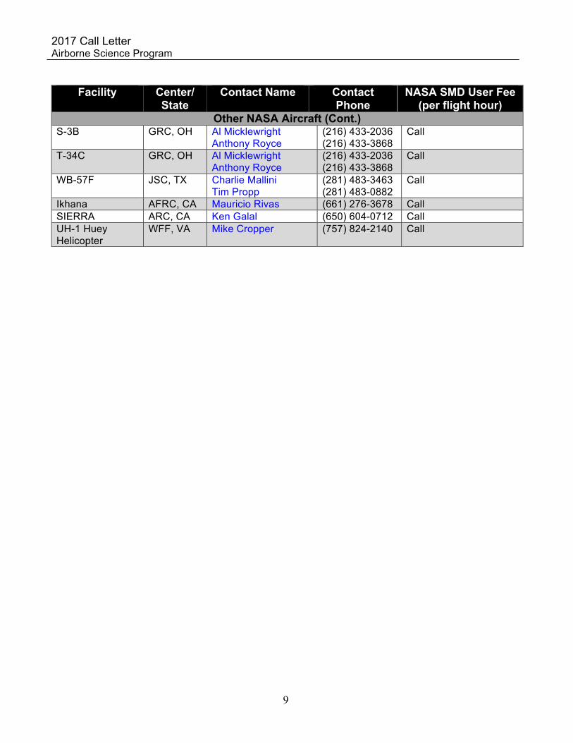
Other NASA Aircraft (Cont.) S-3B GRC, OH Al Micklewright
Anthony Royce (216) 433-2036 (216) 433-3868
Call
T-34C GRC, OH Al Micklewright Anthony Royce
(216) 433-2036 (216) 433-3868
Call
WB-57F JSC, TX Charlie Mallini Tim Propp
(281) 483-3463 (281) 483-0882
Call
Ikhana AFRC, CA Mauricio Rivas (661) 276-3678 Call SIERRA ARC, CA Ken Galal (650) 604-0712 Call UH-1 Huey Helicopter
WFF, VA Mike Cropper (757) 824-2140 Call

2017 Call Letter Airborne Science Program
Revision No. 1 to the FY16 ASP Call Letter was issued on Oct 9, 2015. Revisions to original are in red. 10
Appendix E NASA Facility Instruments and Science Support Assets
Several remote sensing systems are considered as NASA facility instruments, in part because they support multiple science disciplines, and a variety of NASA science objectives. They are supported by managers in the ESD Research and Analysis program, and/or the EOS Project Science Office, and are made available to the wider NASA science community via the Flight Request process. ASP science support assets include the POS-AV system for georeferencing airborne sensor data and the high resolution Digital Mapping System (DMS). Both assets are managed by the Airborne Sensor Facility. In most cases, instrument and Science Support Assets operating and data processing costs are recovered from the requesting individual or their sponsors. Facility Instruments Contact Telephone AVIRIS-C1
Airborne Visible Infrared Imaging Spectrometer – Classic Robert Green 818-354-9136
AVIRIS-NG1 Airborne Visible Infrared Imaging Spectrometer – Next Generation
Robert Green 818-354-9136
eMAS (avail 2017), Enhanced MODIS Airborne Simulator Jeff Myers 650-604-3598 MASTER MODIS-ASTER Simulator Jeff Myers 650-604-3598 LVIS, Land, Vegetation, and Ice Sensor (avail. mid-2016) Bryan Blair 301-614-6741 NAST-I, National Airborne Sounding Testbed-Interferometer Anna Noe 757-864-6466 UAVSAR2, UAV Synthetic Aperture Radar Yunling Lou 818-354-2647 Science Support Assets POS AV, Ames and Wallops Flight Facility Jeff Myers 650-604-3598 DMS, Digital Mapping System Jeff Myers 650-604-3598
1NASA Instrument Concurrence (NSC) by Hank Margolis is required for the use of AVIRIS-C and AVIRIS-NG. 2NASA Instrument Concurrence by Craig Dobson is required for the use of UAVSAR.
AVIRIS-C and AVIRIS-NG JPL operates the AVIRIS-C (Classic) and AVIRIS-NG (Next Generation) Imaging Spectrometers, which are available as NASA facility instruments for scientific research and applications. Investigators will be expected to pay for JPL Imaging Spectrometer data acquisition, calibration, engineering support and processing costs associated with their investigations. If JPL Imaging Spectrometers requirements were approved as part of the original proposal selection, then these costs should already be provided for in your budget or reserved for this purpose at NASA Headquarters. Please contact your Technical Monitor if you have any questions about this. If your JPL Imaging Spectrometer requirements are new and were not in the originally selected proposal, then resources must be found within your existing budget or secured through an augmentation request to your Technical Monitor or Program Manager at NASA Headquarters.
AVIRIS-NG is a new facility instrument that is now available for campaigns on the commercial Twin Otters. AVIRIS-C is currently flying on the NASA ER-2 on a regular basis, as part of the HyspIRI Airborne Preparatory Campaign. The current plan is to fly AVIRIS-C on the ER-2 for cross

2017 Call Letter Airborne Science Program
Revision No. 1 to the FY16 ASP Call Letter was issued on Oct 9, 2015. Revisions to original are in red. 11
calibration and inter-comparison with AVIRIS-NG on the Twin Otter. AVIRIS-C can be flown on the Twin Otter for particular investigations, or AVIRIS-NG can be used for flying higher spectral and spatial sampling collections for Visible to Shortwave IR imaging spectroscopy (380 to 2510 nm). Furthermore, scenes from the AVIRIS-C archive (i.e., data that have already been acquired) can be obtained at a nominal cost and can be located at: http://aviris.jpl.nasa.gov.
MASTER and eMAS The MODIS/ASTER airborne simulator (MASTER) is currently available for flights aboard the NASA ER-2. It may also be integrated on the DC-8 or the P-3B, although it’s expected to fly mainly on the ER-2 in FY17. The enhanced MODIS simulator (eMAS) is planned to be available starting in 2017, please contact Jeff Myers at 650-604-3598 for more information. The calibration and data processing (Level-1b and geolocation) are supported by the Airborne Sensor Facility at NASA Ames Research Center. Higher-level products are possible in some instances; these are supported separately by the eMAS science POC (Dr. Steven Platnick), the MASTER instrument PI (Dr. Simon Hook), or other research teams and should not be assumed in any Flight Request.
Additional information on eMAS or MASTER can be obtained from: Jeff Myers, 650-604-3598 Use/Cost Policies: Dr. Steven Platnick (see Appendix C) Instrument & FY 2017 Schedule: Jeff Myers, 650-604-3598
UAVSAR The Uninhabited Aerial Vehicle Synthetic Aperture Radar (UAVSAR), a high resolution, fully polarimetric, L-band SAR designed for repeat pass InSAR applications, is available as a NASA facility instrument for scientific research and applications. Investigators are expected to pay for UAVSAR data acquisition and processing costs associated with their investigations, unless they were approved as part of the original proposal selection. These costs should already be provided for in your budget or reserved for this purpose at NASA Headquarters. UAVSAR currently flies on the C20-A (or JSC’s G-III) aircraft and has also flown test flights on the Global Hawk.
UAVSAR can also be configured to operate in P-band (also known as AirMOSS) or Ka-band (also known as GLISTIN-A). The P-band and Ka-band instruments are currently not classified as facility instruments although users may request these instruments through SOFRS by selecting UAVSAR and adding the specific frequency (Ka-band or P-band) in the comment field. Flight requests for Ka-band and P-band will incur instrument usage fee in addition to the standard user fee for the Armstrong C20-A or the JSC G-III.
All UAVSAR Flight Requests should clearly identify: (i) a target data collection window (ii) the desired instrument (UAVSAR L-band, P-band, or Ka-band) and (iii) a preliminary flight plan. Flight plans can be prepared using the UAVSAR Flight Planning Tool at http://uavsar.jpl.nasa.gov/cgi-bin/fps. After submission of a preliminary plan, the UAVSAR science coordinator will contact you to refine the data collection strategy and the finalized plan will be used to estimate flight hours and mission peculiar costs. Users are responsible for ensuring that their entire science experiment is accounted for within the submitted Flight Request; any expansion of the scope of the science experiment will require new Flight Request approval.
NASA data acquired by UAVSAR are processed at JPL and archived for distribution at the Alaska

2017 Call Letter Airborne Science Program
Revision No. 1 to the FY16 ASP Call Letter was issued on Oct 9, 2015. Revisions to original are in red. 12
Satellite Facility (http://www.asf.alaska.edu/), where you may download the processed data products at no charge. For more information about UAVSAR, visit http://uavsar.jpl.nasa.gov. JPL's Earth Science Airborne Suborbital Instruments and Measurements website can be found at http://airbornescience.jpl.nasa.gov. NAST-I The National Airborne Sounding Testbed-Interferometer (NAST-I) is a high spectral resolution (0.25cm- 1) and high spatial resolution (0.13 km linear resolution per km of aircraft flight altitude, at nadir) scanning (2.3 km ground cross-track swath width per km of aircraft flight altitude) interferometer sounding system was developed to be flown on high-altitude aircraft to provide experimental observations needed to finalize the specifications and to test proposed designs and data processing algorithms for the Cross-track Infrared Sounder (CrIS) flying on the current Suomi NPP (SNPP) and future Joint Polar Satellite System (JPSS) platforms. Because the NAST-I spectral radiance and temperature and humidity soundings have an unprecedented spectral and spatial resolution, respectively, the data are being used to support a variety of satellite sensor calibration / validation and atmospheric research programs. The NAST-I covers a spectral range from ~ 600-2900 cm-1 (3.5-16 microns) with 0.25 cm-1 spectral resolution, yielding more than 9000 spectral channels of radiance emission information. The NAST-I passive infrared (IR) Michelson interferometer is often flown with the NAST passive microwave sounding instrument (NAST-M, from MIT LL) to provide an all-weather sounding capability. The NAST-I and NAST-M instruments fly on the ER-2, WB-57, and Proteus aircraft; and NAST-I has begun efforts to become operational on the DC-8. LVIS (available as early as mid-2016) The Land, Vegetation, and Ice Sensor (LVIS) is an airborne, full-waveform, scanning laser altimeter, designed and developed at NASA's Goddard Space Flight Center (GSFC). By combining precise GPS, attitude sensor data, and the range and return waveforms, LVIS produces large area maps of surface topography, and any vertical height and structure. The facility version of the sensor is estimated to become available for planning in mid/late 2016. Interested users are encouraged to contact Bryan Blair ([email protected], 301-614-6741) (alternate contact: David Rabine [email protected], 301-614-6771)) for further details of the facility capabilities with respect to data requirements. Standard data products include: Level1b - the geolocated return laser waveform and Level2 - elevation and height products extracted from the Level1b waveform using standard algorithms. The decimeter-accurate topography maps and precisely geolocated return waveforms produced by LVIS provide Earth scientists with a unique data set for studies such as topography, hydrology, land ice, sea ice, biodiversity, and ecology.
POS AV User fees apply POS AV (Postion and Orientation Systems) are standalone precision navigation systems specifically designed for direct georeferencing of airborne sensor data. By integrating precision GPS with inertial measurement technology, POS AV provides high-resolution aircraft attitude and position data for use by Lidars, imaging systems, and air sampling instruments. These systems and their support staff are in high demand. Loans may be restricted to “expert users”. Please contact Jeff Myers regarding availability (650-604-3598).

2017 Call Letter Airborne Science Program
Revision No. 1 to the FY16 ASP Call Letter was issued on Oct 9, 2015. Revisions to original are in red. 13
DMS User fees apply The Digital Mapping System (DMS) is a 22 megapixel digital camera that acquires high resolution natural color or panchromatic aerial imagery. Data acquired by DMS are used by a variety of scientific programs to monitor variation in environmental conditions, assess global change, and respond to natural disasters. Geo-referenced image products may be generated, when used in conjunction with a POS AV system.

2017 Call Letter Airborne Science Program
Revision No. 1 to the FY16 ASP Call Letter was issued on Oct 9, 2015. Revisions to original are in red. 14
Appendix F NASA Program Managers/Scientists
This table of NASA Program Managers/Scientists is provided for information only, as a service to investigators. Name Organization Area of Responsibility
SCIENCE David Considine NASA - SMD Modeling Analysis and Prediction Paula Bontempi NASA - SMD Carbon Cycle and Ecosystems-
Ocean Biology and Biogeochemistry Craig Dobson NASA - SMD Geodetic Imaging Program Hank Margolis NASA - SMD Terrestrial Ecology Program Jared Entin NASA - SMD Hydrology Program Garik Gutman NASA - SMD Land Use-Land Cover Ken Jucks NASA - SMD Upper Atmosphere Research Program Tsengdar Lee NASA - SMD Atmospheric Dynamics and Precipitation
Program Ben Phillips NASA - SMD Earth Surface Interior Jeff Grossman NASA - SMD Astro-Materials Curation Eric Lindstrom NASA - SMD Oceanography Hal Maring NASA - SMD Radiation Science Program Barry Lefer NASA - SMD Tropospheric Composition Tom Wagner NASA - SMD Cryosphere and International Polar Year Bruce Tagg NASA - SMD Airborne Science Program Woody Turner NASA - SMD Biological Diversity
ESTO Parminder Ghuman NASA - GSFC Earth Science Technology Office (IIP) Pam Millar NASA - GSFC Earth Science Technology Office (AITT) Mike Little NASA - GSFC Earth Science Technology Office (AIST) Joe Famiglietti NASA - GSFC Earth Science Technology Office (ACT)
SATELLITES Steve Platnick NASA - GSFC EOS Project Science Office Jeff Masek NASA - GSFC Landsat Program
APPLIED SCIENCE Lawrence Friedl NASA - SMD Applied Science Program
David Green NASA - SMD Disaster Management Lucien Cox NASA - SMD Applied Science