Revised stratigraphy and age of the Red Sandstone Group in ... etal_2004_Red Sandstone... ·...
11
Revised stratigraphy and age of the Red Sandstone Group in the Rukwa Rift Basin, Tanzania Eric M. Roberts a, * , Patrick M. O’Connor b , Michael D. Gottfried c , Nancy Stevens b , Saidi Kapalima d , Sifael Ngasala d a Department of Geology and Geophysics, University of Utah, Salt Lake City, UT 84112, USA b College of Osteopathic Medicine, Ohio University, Athens, OH 45701, USA c Department of Geological Sciences, Michigan State University, East Lansing, MI 48824, USA d Department of Geology, University of Dar es Salaam, Tanzania Received 19 November 2003; accepted in revised form 29 June 2004 Available online 21 August 2004 Abstract The Red Sandstone Group comprises a succession of red sandstones and mudstones exposed in the Rukwa and Malawi rift basins of southwestern Tanzania and northern Malawi. Stratigraphic, sedimentologic, and paleontologic investigations of the Red Sandstone Group in the Songwe Basin (a sub-basin of the Rukwa Rift Basin) help clarify the age and depositional history of these strata, which have previously been assigned ages ranging from Middle Jurassic to late Miocene. These seemingly incompatible Mesozoic and Tertiary age assignments for the Red Sandstone Group are, in part, explained by our discovery of two distinct units (Units I and II) that are of different ages but composed of lithologically similar red sandstones and mudstones in the Songwe Basin. Based on distinct, temporally limited vertebrate fossil remains, a Cretaceous age is proposed for Unit I and a Paleogene age for Unit II. The identification of different-aged units in the Songwe Basin suggests a complex structural and stratigraphic history for the Red Sandstone Group in the context of East African Rift evolution. Ó 2004 Elsevier Ltd. All rights reserved. Keywords: Cretaceous; Africa; Gondwana; Tanzania; Red Sandstone Group 1. Introduction The Rukwa Rift Basin in southwestern Tanzania contains up to 11 km of Permian to Holocene sedimen- tary fill, making it the thickest package of sedimentary strata in the East African Rift System (EARS) (Wheeler and Karson, 1994), and the subject of recent exploration to assess its potential as a petroleum-producing basin (see Morley et al., 1999). A number of workers have sought to better characterize the complex structural and stratigraphic history of the basin, and a considerable amount of debate has been generated concerning the exact nature and timing of tectonic and depositional events in the rift (e.g., Ebinger et al., 1989; Wescott et al., 1991; Kilembe and Rosendahl, 1992; Wheeler and Karson, 1994; van der Beek et al., 1998). Particularly problematic are the inconsistent nomenclature and variable age assignments of red sandstones and mud- stones which crop out below the Pliocene–Holocene East African Rift strata (Lake Beds sensu Grantham, 1932) and above the upper Paleozoic and lower Mesozoic strata of the Karoo Supergroup. The name ‘‘Red Sandstones’’ was originally used by Spence (1954) to describe the series of red sandstones and mudstones exposed near the Galula coalfields (see Fig. 1), although a formal type section with a detailed description was * Corresponding author. E-mail address: [email protected] (E.M. Roberts). 0195-6671/$ - see front matter Ó 2004 Elsevier Ltd. All rights reserved. doi:10.1016/j.cretres.2004.06.007 www.elsevier.com/locate/CretRes Cretaceous Research 25 (2004) 749–759
Transcript of Revised stratigraphy and age of the Red Sandstone Group in ... etal_2004_Red Sandstone... ·...
www.elsevier.com/locate/CretRes
Cretaceous Research 25 (2004) 749–759
Revised stratigraphy and age of the Red Sandstone Groupin the Rukwa Rift Basin, Tanzania
Eric M. Robertsa,*, Patrick M. O’Connorb, Michael D. Gottfriedc,Nancy Stevensb, Saidi Kapalimad, Sifael Ngasalad
aDepartment of Geology and Geophysics, University of Utah, Salt Lake City, UT 84112, USAbCollege of Osteopathic Medicine, Ohio University, Athens, OH 45701, USA
cDepartment of Geological Sciences, Michigan State University, East Lansing, MI 48824, USAdDepartment of Geology, University of Dar es Salaam, Tanzania
Received 19 November 2003; accepted in revised form 29 June 2004
Available online 21 August 2004
Abstract
The Red Sandstone Group comprises a succession of red sandstones and mudstones exposed in the Rukwa and Malawi rift
basins of southwestern Tanzania and northern Malawi. Stratigraphic, sedimentologic, and paleontologic investigations of the RedSandstone Group in the Songwe Basin (a sub-basin of the Rukwa Rift Basin) help clarify the age and depositional history of thesestrata, which have previously been assigned ages ranging from Middle Jurassic to late Miocene. These seemingly incompatible
Mesozoic and Tertiary age assignments for the Red Sandstone Group are, in part, explained by our discovery of two distinct units(Units I and II) that are of different ages but composed of lithologically similar red sandstones and mudstones in the Songwe Basin.Based on distinct, temporally limited vertebrate fossil remains, a Cretaceous age is proposed for Unit I and a Paleogene age for Unit
II. The identification of different-aged units in the Songwe Basin suggests a complex structural and stratigraphic history for the RedSandstone Group in the context of East African Rift evolution.� 2004 Elsevier Ltd. All rights reserved.
Keywords: Cretaceous; Africa; Gondwana; Tanzania; Red Sandstone Group
1. Introduction
The Rukwa Rift Basin in southwestern Tanzaniacontains up to 11 km of Permian to Holocene sedimen-tary fill, making it the thickest package of sedimentarystrata in the East African Rift System (EARS) (Wheelerand Karson, 1994), and the subject of recent explorationto assess its potential as a petroleum-producing basin(see Morley et al., 1999). A number of workers havesought to better characterize the complex structural andstratigraphic history of the basin, and a considerable
* Corresponding author.
E-mail address: [email protected] (E.M. Roberts).
0195-6671/$ - see front matter � 2004 Elsevier Ltd. All rights reserved.
doi:10.1016/j.cretres.2004.06.007
amount of debate has been generated concerning theexact nature and timing of tectonic and depositionalevents in the rift (e.g., Ebinger et al., 1989; Wescottet al., 1991; Kilembe and Rosendahl, 1992; Wheeler andKarson, 1994; van der Beek et al., 1998). Particularlyproblematic are the inconsistent nomenclature andvariable age assignments of red sandstones and mud-stones which crop out below the Pliocene–HoloceneEast African Rift strata (Lake Beds sensu Grantham,1932) and above the upper Paleozoic and lowerMesozoic strata of the Karoo Supergroup. The name‘‘Red Sandstones’’ was originally used by Spence (1954)to describe the series of red sandstones and mudstonesexposed near the Galula coalfields (see Fig. 1), althougha formal type section with a detailed description was

750 E.M. Roberts et al. / Cretaceous Research 25 (2004) 749–759
Fig. 1. Location of the Rukwa Rift Basin and the major areas in which the Red Sandstone Group is exposed in southwestern Tanzania (modified
from Damblon et al., 1998).
never presented. Numerous names have been applied tothis sedimentary succession since Spence’s (1954) work,including: the ‘‘Red Beds’’ (Pentelkov, 1979); the ‘‘RedBed Sandstone Sequence’’ or the ‘‘Red Bed SandstoneFormation’’ (Kilembe and Rosendahl, 1992); the ‘‘RedSandstone Formation’’ (Wescott et al., 1991); and the‘‘Red Sandstone Group’’ (Dypvik et al., 1990; Damblonet al., 1998; Morley et al., 1999). The isolated nature ofoutcrop belts in which these strata are exposed, and theconsiderable variation in lithologies that exists betweenthese belts, are further complicating factors (Dypviket al., 1990). We follow Dypvik et al. (1990) and othersand use the term Red Sandstone Group for all exposuresof red sandstones and mudstones that are stratigraph-ically between the Karoo Supergroup and the Lake Bedsstrata.
A more serious problem relates to the age of RedSandstone Group strata within the region. Proposedages range from Middle Jurassic to late Miocene(Fig. 2). Spence (1954) and others (e.g., Spurr, 1954;Grantham et al., 1958) originally considered the RedSandstone Group to be Cretaceous based upon litho-logical similarities with Cretaceous dinosaur-bearingbeds in Malawi (Dixey, 1928; Jacobs et al., 1990).Quennell et al. (1956) and later Pentelkov (1979)
suggested a Late Jurassic age based on long-rangelithological correlations with well-dated red beds ex-posed along the southern coast of Tanzania andMozambique. Several other workers have proposedages between Middle Jurassic and Early Cretaceousbased on unidentified reptile bone fragments nearGalula (Pallister, 1963), fossil dinosaur eggs along theSongwe River (Swinton, 1950), ‘‘relics of mollusks andreptiles’’ near Usevia (Smirnov et al., 1974), andstratigraphic relationships with intrusive carbonatitesnear Mbeya (Pentelkov and Voronovskii, 1977).
Recent investigations by the AMOCO ProductionCompany (e.g., drilling of two hydrocarbon explorationwells: Ivuna-1 and Galula-1; see Fig. 1) have added to thedebate about the age of the Red Sandstone Group (seeMorley et al., 1999). Based upon palynological assemb-lages recovered from sidewall cores and cuttings fromboth the Ivuna-1 andGalula-1 wells,Wescott et al. (1991)reported a Miocene–Pliocene age for the Red SandstoneGroup on the basis of a sparse number of the diatomsMelosira granulata and/or M. agassizii (Fig. 2). Bothspecies are known from the upper Miocene–Holocene ofAfrica and are typically found in freshwater (lacustrine)environments with high dissolved silica levels (Wescottet al., 1991). However, Kilembe and Rosendahl (1992)

751E.M. Roberts et al. / Cretaceous Research 25 (2004) 749–759
Fig. 2. Recent stratigraphic interpretations for the Rukwa and northern Malawi rift basins. Results from this study (Songwe Basin) are highlighted in
gray.
also examined cuttings from the same twowells and failedto document the presence ofMelosira. They did, however,find rare examples of the wind-blown pollen Classopollisclassoides and Callialasporites dampieri, which suggesta Middle Jurassic–middle Cretaceous age for thesedeposits (Fig. 2; Kilembe and Rosendahl, 1992). Morleyet al. (1999) favored a Neogene age for the group, notingthat the pollen grains reportedbyKilembe andRosendahl(1992) are also found in the Cretaceous bentonite used asdrilling mud in the two wells, and is thus a contaminant.Most recently, Damblon et al. (1998) identified a smallfragment of silicified fossil wood (from near the Songwe-Kiwira coal mines just north of the Malawi border) asPahudioxylon, a taxon restricted to the late Cenozoic,lending additional support to other assessments ofa Neogene age for the Red Sandstone Group (Fig. 2).
In light of these problems, we present definitive newevidence on the age of the Red Sandstone Group in theSongwe Basin region of the Rukwa Rift. Structural,stratigraphic, and paleontologic evidence collected in theSongwe Basin reveals the existence of two lithologicallysimilar units, one Cretaceous and one Tertiary, whichcrop out within several kilometers of each other. Thesenew data help to delineate and clarify critical aspects ofstratigraphy and basin evolution in the Rukwa Rift.
2. Geologic setting/context
The Rukwa Rift is a roughly 300 km long by 50 kmwide, northwest–southeast-trending segment of the
Western Branch of the East African Rift System,located in southwestern Tanzania between LakesTanganyika and Nyasa (Malawi) (Fig. 1). Much of thebasin is currently occupied by Lake Rukwa, a shallow(!15 m deep) lake fed by the Songwe and Mombarivers from the south and the Kavu and Rungwe riversfrom the north. Structurally, the Rukwa Rift displaysclassic half-graben architecture, flanked by upliftedPrecambrian Pan-African metamorphic rocks (Kilembeand Rosendahl, 1992). The rift basin is bound by theUfipa fault and plateau to the southwest, the Lupa faultto the northeast, the Ubende plateau to the north, andthe Mbozi block and Rungwe volcanics to the south(Ebinger et al., 1989; Kilembe and Rosendahl, 1992).Significantly, the Rukwa Rift follows the trend ofPrecambrian basement foliation, and various workers(e.g., Kilembe and Rosendahl, 1992; Wheeler andKarson, 1994) have demonstrated a minimum of threedistinct phases of tectonic activity, beginning in thePermian.
Three major stratigraphic sequences have beendelineated in the Rukwa Rift Basin, each correlatedwith separate tectonic events between the Permian andHolocene. However, the exact timing and structuralregime associated with these rifting events is debat-able. Specifically, the mechanism of basin developmentin the Rukwa Rift has been described variously aspurely extensional, purely strike-slip, and some com-bination of the two styles (Ebinger et al., 1989;Kilembe and Rosendahl, 1992; Wheeler and Karson,1994).

752 E.M. Roberts et al. / Cretaceous Research 25 (2004) 749–759
2.1. Karoo Supergroup
The timing of Permian tectonism and basindevelopment is well documented and generallynon-contentious (van der Beek et al., 1998). This eventwas related to the break-up of Pangaea, and resulted inthe initial deposition of Karoo sediments in the RukwaRift Basin and widespread deposition in other well-known Karoo basins across southern Africa, Madagas-car, and South America (Wopfner, 2002). The KarooSupergroup in the Rukwa Rift is composed of a series ofglacial, lacustrine, and fluvial deposits of Permian–Triassic age. These units are dominated by oxidizedmudstones and sandstones, conglomerates, carbonatesand coals (Dypvik et al., 1990).
2.2. Red Sandstone Group
The Red Sandstone Group lies with angular un-conformity on the Karoo Supergroup, commonlyexhibiting a dip angle of 10–30 � (Dypvik et al., 1990).Deposition of the Red Sandstone Group was likelyrelated to renewed tectonic activity along pre-existingbasement structures, possibly associated with the break-up of Gondwanaland (Dypvik et al., 1990). Exposuresof the Red Sandstone Group crop out in isolatedexposure belts along the margin of the rift, and areknown from the Songwe Basin (our primary field area),Galula (along the Tembo, Mtuka, and Chizi rivers),Usevia, and in the Songwe-Kiwira and Rungwe areas(both of which are actually located in the northern endof the Malawi Rift Basin) (Fig. 1). Although the lattertwo areas are not specifically within the Rukwa RiftBasin, they are thought to be correlative in age (Harkinand Harpum, 1957; Grantham et al., 1958; Dypvik et al.,1990). Each area is typified by differences in sandstone/mudstone ratios, paleocurrent direction, grain size, andfossil content and preservation (Dypvik et al., 1990).
The Red Sandstone Group is up to several hundredmeters thick in outcrop, and sub-surface measurementsexceed 900 m (Wescott et al., 1991; Kilembe andRosendahl, 1992; Morley et al., 1999). Medium-grained,red-purple sandstone with occasional pebble lensesdominate much of the section; however, thin, lenticularred mudstones and siltstone are also common. Withinand to the south of the Songwe-Kiwira area, Dixey(1928) and Dypvik et al. (1990) subdivided the groupinto lower and upper units. They documented a lower,coarse-grained, sandstone-conglomerate interval, over-lain by a finer-grained upper unit dominated by marls,becoming sandier towards the north.
2.3. Lake beds sequence
The ‘‘Lake Beds’’ form the third major depositionalsequence in the Rukwa Rift Basin, and are related to
late Tertiary–Pleistocene rifting associated with themodern East Africa Rift System (Quennell et al.,1956). Lake Beds strata are well exposed, particularlyto the east of Galula; they are typically composed ofunconsolidated alluvium, sand, mud and volcanic silt,and were deposited in fluvial, alluvial, and lacustrinedepositional systems (Wescott et al., 1991; Kilembe andRosendahl, 1992). The contact between the Lake Bedssequence and the underlying Red Sandstone Group istypically erosional (Ebinger et al., 1989). Granthamet al. (1958) subdivided the Lake Beds sequence intolower and upper units; however, detailed stratigraphicand facies relationships of the Lake Beds sequence arestill poorly understood. Their age is generally wellconstrained, based on radiometric dating of intercalatedash beds and palynological analysis of core samples(Ebinger et al., 1989; Wescott et al., 1991).
3. Methods
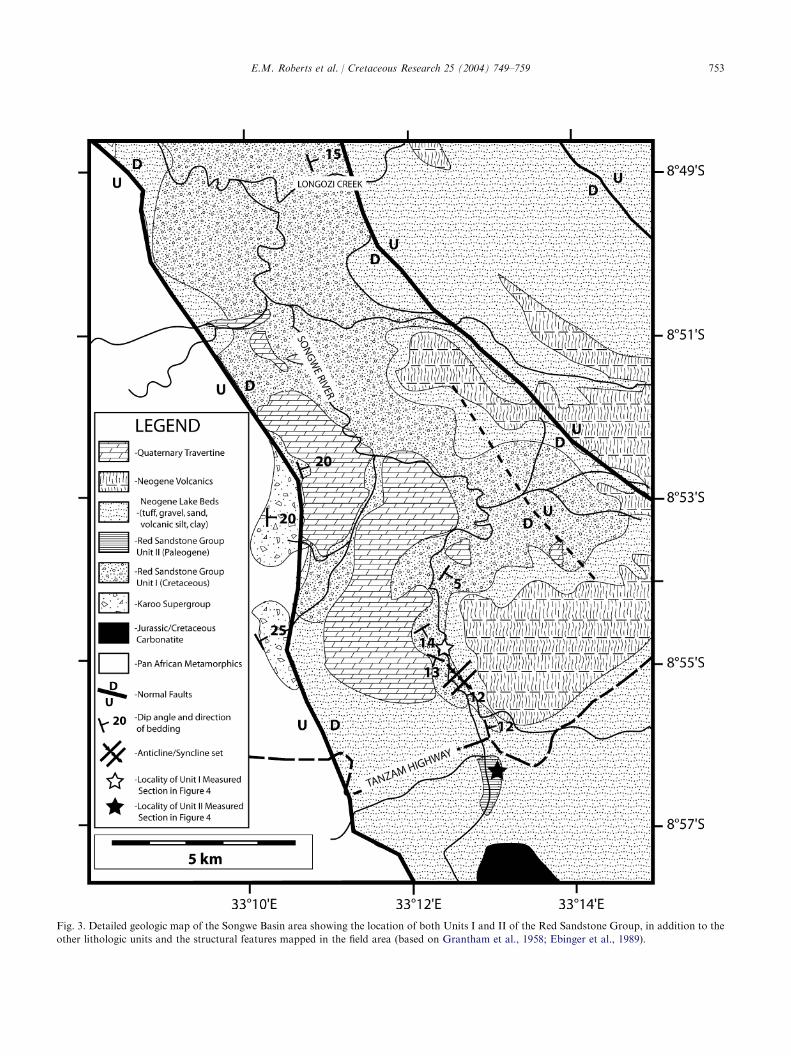
Our data were collected during the austral winters of2002 and 2003 as part of an exploratory project aimed atidentifying Cretaceous vertebrate localities in south-western Tanzania. The majority of the fieldwork wasconcentrated in the Songwe Basin, between the ‘‘Tan-zam Highway’’ and the confluence of Longozi Creekwith the Songwe River to the north (Fig. 3). Additionaloutcrops were examined in the Songwe-Kiwira and theGalula coalfield areas (along the Mtuka River) (Fig. 1).In addition to excavation and collection of fossilvertebrates, rocks were systematically collected forpetrographic, radiometric, and palynological analysis.Seven detailed stratigraphic sections were measured inthe Songwe Basin. Paleocurrent measurements wererecorded on troughs of three-dimensionally exposedcross-beds. The Mbeya quarter-degree geological mapproduced by Grantham et al. (1958) was used as a basemap for more detailed geological mapping. Extensivefield investigations utilizing GPS and Brunton compasswere employed to help clarify stratigraphic and struc-tural complexities, particularly relating to the RedSandstone Group.
4. Stratigraphy and sedimentology of the Red
Sandstone Group in the Songwe Basin
Two different units, both mapped as Red SandstoneGroup, were identified in the field area for the first time(Figs. 2–4). Herein, these are informally referred to asUnit I and Unit II. Unit I is best exposed along theSongwe River north of the Tanzam Highway, whereasUnit II is known from isolated exposures to the south ofthe highway (Fig. 3). Unit II exhibits minor lithologicaldifferences from Unit I; however, mammalian fossils
753E.M. Roberts et al. / Cretaceous Research 25 (2004) 749–759
Fig. 3. Detailed geologic map of the Songwe Basin area showing the location of both Units I and II of the Red Sandstone Group, in addition to the
other lithologic units and the structural features mapped in the field area (based on Grantham et al., 1958; Ebinger et al., 1989).
754 E.M. Roberts et al. / Cretaceous Research 25 (2004) 749–759
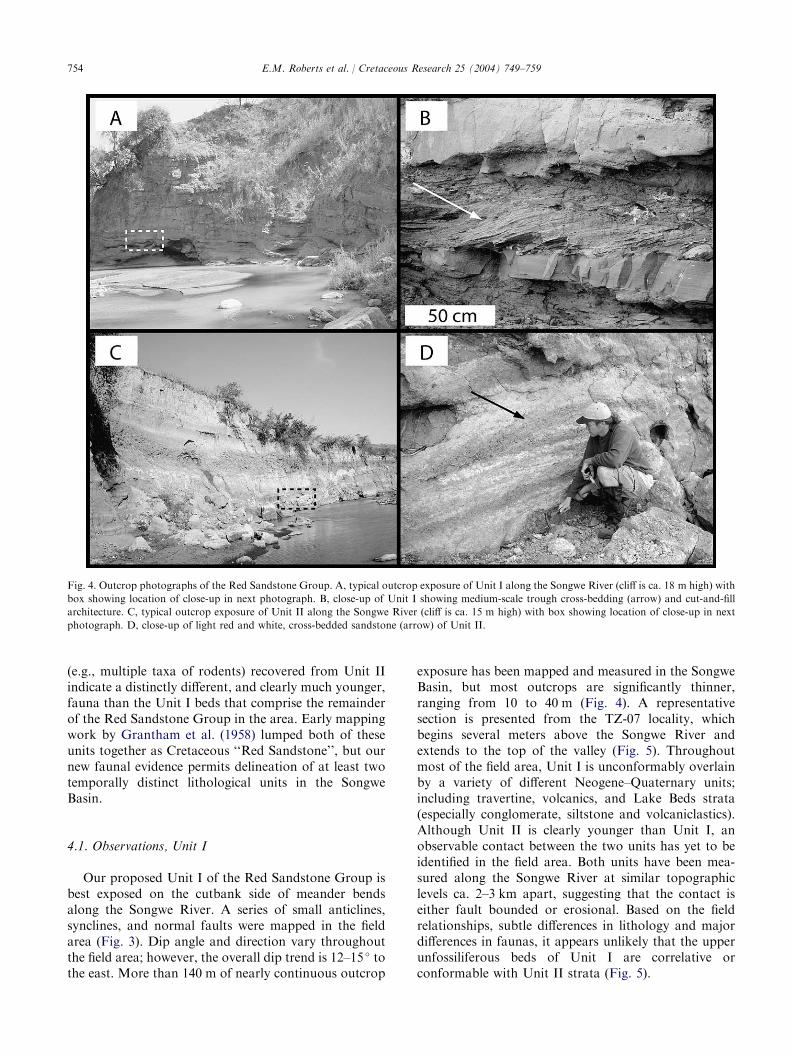
Fig. 4. Outcrop photographs of the Red Sandstone Group. A, typical outcrop exposure of Unit I along the Songwe River (cliff is ca. 18 m high) with
box showing location of close-up in next photograph. B, close-up of Unit I showing medium-scale trough cross-bedding (arrow) and cut-and-fill
architecture. C, typical outcrop exposure of Unit II along the Songwe River (cliff is ca. 15 m high) with box showing location of close-up in next
photograph. D, close-up of light red and white, cross-bedded sandstone (arrow) of Unit II.
(e.g., multiple taxa of rodents) recovered from Unit IIindicate a distinctly different, and clearly much younger,fauna than the Unit I beds that comprise the remainderof the Red Sandstone Group in the area. Early mappingwork by Grantham et al. (1958) lumped both of theseunits together as Cretaceous ‘‘Red Sandstone’’, but ournew faunal evidence permits delineation of at least twotemporally distinct lithological units in the SongweBasin.
4.1. Observations, Unit I
Our proposed Unit I of the Red Sandstone Group isbest exposed on the cutbank side of meander bendsalong the Songwe River. A series of small anticlines,synclines, and normal faults were mapped in the fieldarea (Fig. 3). Dip angle and direction vary throughoutthe field area; however, the overall dip trend is 12–15 � tothe east. More than 140 m of nearly continuous outcrop
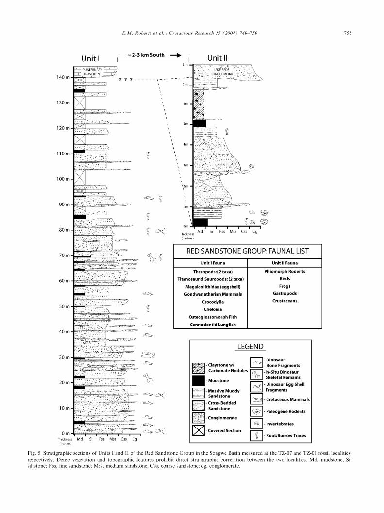
exposure has been mapped and measured in the SongweBasin, but most outcrops are significantly thinner,ranging from 10 to 40 m (Fig. 4). A representativesection is presented from the TZ-07 locality, whichbegins several meters above the Songwe River andextends to the top of the valley (Fig. 5). Throughoutmost of the field area, Unit I is unconformably overlainby a variety of different Neogene–Quaternary units;including travertine, volcanics, and Lake Beds strata(especially conglomerate, siltstone and volcaniclastics).Although Unit II is clearly younger than Unit I, anobservable contact between the two units has yet to beidentified in the field area. Both units have been mea-sured along the Songwe River at similar topographiclevels ca. 2–3 km apart, suggesting that the contact iseither fault bounded or erosional. Based on the fieldrelationships, subtle differences in lithology and majordifferences in faunas, it appears unlikely that the upperunfossiliferous beds of Unit I are correlative orconformable with Unit II strata (Fig. 5).
755E.M. Roberts et al. / Cretaceous Research 25 (2004) 749–759
Fig. 5. Stratigraphic sections of Units I and II of the Red Sandstone Group in the Songwe Basin measured at the TZ-07 and TZ-01 fossil localities,
respectively. Dense vegetation and topographic features prohibit direct stratigraphic correlation between the two localities. Md, mudstone; Si,
siltstone; Fss, fine sandstone; Mss, medium sandstone; Css, coarse sandstone; cg, conglomerate.

756 E.M. Roberts et al. / Cretaceous Research 25 (2004) 749–759
Unit I is dominated by thick sequences of deep red(5R 2/6), pale red-purple (5RP 6/2), and grayish purple(5P 4/2) sandstones (Figs. 4, 5) which are poorly–moderately sorted, fine–very coarse-grained and wellcemented. Trough cross-stratification is the most com-mon sedimentary structure observed, but tabular cross-stratification and planar bedding are also present.Cross-bed sets range from small- to large-scale. Pebblelenses 3–35 cm thick are common along the basalsurface of sandstone beds, particularly in the lower50–75 m of the section. The upper 75–100 m of thesection is finer-grained, with fewer pebble lenses.Petrographic analysis reveals both texturally andcompositionally immature sandstones, dominated byquartz (ca. 70%), potassium feldspar (ca. 20%), lithicand metamorphic rock fragments (ca. 10%), and claymatrix. Pebble lenses are clast supported and dominatedby intra-formational mudstone rip-up clasts (ca. 50–70%), metamorphic rock fragments (20%), lithic rockfragments (ca. 5–10%), minor bone fragments (!5%),and minimal matrix. Sandstones are highly amalgam-ated and composed of stacked, fining-upward bedsranging from 0.2–3 m thick. Individual beds arelenticular to tabular, with abundant erosional trunca-tion and scour surfaces. Paleocurrent measurementstaken from throughout the section and at numerousseparate localities are remarkably consistent, showingflow to the northwest with a mean azimuth of 294 �
(nZ 68).Dark red (5R 2/6) mudstone and siltstone beds
comprise ca. 10% of Unit I. These beds are commonlythin (!1 m), lenticular, and truncated by sandstonebeds. Rare trace fossils (Skolithos and Planolites) andcalcareous rhizoliths are found within both siltstone andmudstone units. Vertebrate fossils are preserved inpebble lag, sandstone, siltstone, and mudstone facies,with the best preservation occurring in the latter two.
4.2. Interpretations, Unit I
We interpret Unit I as resulting from deposition byfluvial and floodplain processes in a continental riftsetting. Paleocurrent measurements suggest that sand-stone beds primarily reflect deposition by a northwest-flowing river system oriented parallel to the axis of thebasin. The proximity of these rocks to the southernmargin of the Rukwa Rift, in conjunction with thecoarse, immature nature of the sandstones suggestsa proximal source area. Basal pebble lenses areinterpreted as channel lag deposits, while the thin,discontinuous mudstones and siltstones represent flood-plain deposits. Evidence of rare calcareous rhizolithsand heavy oxidation indicates at least moderatepedogenesis. Abundant erosional scour and truncationof mudstone and sandstone beds demonstrate limitedaccommodation space during the deposition of Unit I,
and indicate that lateral braid plain migration andcannibalization of floodplain fines was common.
Dypvik et al. (1990) examined the sandstone petrol-ogy of the Red Sandstone Group and noted the pre-ponderance of chemically weathered grains; thus, theysuggested that these strata were deposited under warm,subtropical conditions in which heavy rains may havebeen common.
4.3. Observations, Unit II
A second lithologic unit identified in the SongweBasin, Unit II, is known from limited outcrop areaslocated south of the Tanzam Highway along the SongweRiver (Figs. 3, 4). Unit II is erosionally truncated byoverlying Pliocene–Quaternary Lake Beds strata, in-cluding conglomerate, siltstone and vitric tuff. It reachesa maximum thickness of 8 m and can be traced laterallyfor several hundred meters before it is erosionallytruncated by overlying beds and/or covered by densevegetation. In contrast to Unit I, Unit II is significantlylighter in color and dominated by orange-red (10R 6/6),reddish brown (10R 4/6) and grayish pink (10R 8/2)sandstones, mottled red (5R 4/6) and greenish gray(5GY 6/1) mudstone, and purplish red (5RP 2/2)claystone with white (N9) carbonate horizons (Figs. 4,5). Unit II sandstone beds are typically less well-cemented than those in Unit I, and show both lenticularchannel form and sheet architecture. They consist ofmedium–coarse, poorly–moderately sorted sand in a claymatrix (Fig. 4). Thin, 1–10 cm, pebble lenses arecommonly present near the base of sandstone beds.Petrographically, Unit II is compositionally similar toUnit I, being composed of quartz (60%), lithic, igneousand metamorphic rock fragments (25%), and feldspar(15%). Beds range from 0.1–1 m thick, and are typicallymassive to trough cross-stratified (small-medium scale).Vertebrate and invertebrate fossils, including internalcasts of gastropods, crustacean claws, and small,isolated bones and teeth are common in the massivesandstone and mudstone beds near the base of thesection (Fig. 4).
Mudstones are more common than in Unit I. Theyare typically sandy and red colored, with greenishreduction halos, and abundant root mottling andcalcareous rhizoconcretions. Slickensides are also pres-ent in varying abundance. Distinctive purplish redclaystone crops out in the upper half of the sectionand contains well-developed, white nodular carbonatehorizons. Such claystone is unique to Unit II, makingthis facies a useful criterion for field recognition.
4.4. Interpretations, Unit II
Unit II is also continental in origin. Lenticularsandstone beds are interpreted to represent fluvial

757E.M. Roberts et al. / Cretaceous Research 25 (2004) 749–759
channel deposits, whereas massive, muddy sandstonesprobably represent higher energy flood deposits. Pebblelenses are interpreted as channel lags, while mudstone,siltstone, and claystone beds are floodplain deposits.The presence of nodular carbonate horizons, calcareousrhizoconcretions, slickensides, deep oxidization, andreduction halos all demonstrate moderate–intense pe-dogenesis on the floodplain. Based on these pedogenicfeatures, a relatively warm, seasonally arid depositionalenvironment is suggested for Unit II.
4.5. Fauna, taphonomic modes, and age of the RedSandstone Group in the Songwe Basin
Wescott et al. (1991) and others have reporteda paucity of vertebrate fossils in the Red SandstoneGroup. In contrast, we recovered a relatively abundantand moderately diverse fossil assemblage from the studyarea within the Songwe Basin. Twelve fossil-bearinglocalities were discovered during the 2002 and 2003 fieldseasons. Of these, 11 sites are located in Unit I, whereasonly one site is in Unit II. Preliminary study of fossilmaterial has provided new data on the age of the RedSandstone Group, definitively demonstrating the pres-ence of two different time-stratigraphic units (Units Iand II) in the Songwe Basin (Figs. 2, 3).
4.5.1. Fossils, Unit IFossils identified thus far in Unit I comprise a range
of isolated to partially articulated specimens, andrepresent a diverse fauna, including sauropod andtheropod dinosaur fossils, (probable) titanosaurid sau-ropod eggshell, teleost (osteoglossomorph) fish, lung-fish, crocodiles, turtles, birds, and mammals (e.g.,Krause et al., 2003; O’Connor et al., 2003; Gottfriedet al., 2004). Many localities contain isolated remains,particularly within the basal pebble conglomerates offluvial sandstones. In contrast, other localities preserveassociated to partially articulated specimens (e.g.,dinosaurs) that demonstrate the in situ nature of fossilmaterial in Unit I. More specifically, one locality con-tains the associated and partially articulated skeleton ofa titanosaurian sauropod within a muddy siltstone(Fig. 5; Unit I measured section ca. 69 m level). Thisspecimen preserves delicate cervical ribs, articulatedvertebrae, associated ribs, teeth, portions of the pectorallimb and a variety of other elements that clearlydemonstrate the autochthonous nature of the specimenand the low-energy conditions in which it was buried(Fig. 6).
The presence of in situ nonavian dinosaurs allowsus to reject a Tertiary age assignment for Unit I.Furthermore, the recovery of osteoglossomorph fish andgondwanatherian mammals suggests a Cretaceous agefor this fauna (Krause et al., 2003; O’Connor et al.,2003).
4.5.2. Fossils, Unit IIA distinctly different fauna was recovered from Unit
II that indicates a much younger age. The one localityidentified thus far (TZ-01) preserves a diverse assem-blage of gastropods, crustaceans, fish, frogs, crocodiles,birds, and mammals. The locality is dominated by small(!2–3 cm), isolated vertebrate remains, including nu-merous rodent jaws and teeth, and various frog, rodentand bird limb elements. The majority of fossil materialcomes from a laterally extensive microsite located ina massive muddy, medium–coarse-grained, tabularsandstone bed that is interpreted either as a channellag, or more likely, as a flood deposit. Preliminaryanalysis of the fauna suggests a late Paleogene age forthe unit based primarily upon the presence of multiplephiomorph rodent taxa currently under study by one ofus (NS). These taxa are narrowly restricted to earlyOligocene deposits elsewhere in Africa, such as theupper levels of the Jebel el Qatrani Formation of Egypt
Fig. 6. Examples of dinosaur fossils recovered from the older Unit I of
the Red Sandstone Group (TZ-07 Locality). A, dorsal rib (and other
bones) of a sauropod dinosaur (NMT02100). B, theropod dinosaur
tooth (NMT02088). C, sauropod dinosaur tooth (NMT02093).

758 E.M. Roberts et al. / Cretaceous Research 25 (2004) 749–759
(Schneider, 1984; Kappelman et al., 1992; Holroyd,1994). Our age assessment is consistent with findings inother parts of the Rukwa and Malawi rift basins thatsupport Tertiary basin development and sedimentationevents (e.g., Tiercelin et al., 1988; Wescott et al., 1991;Damblon et al., 1998; van der Beek et al., 1998);however, this is the first reported Paleogene ageassignment, supported by faunal evidence, for the RedSandstone Group.
5. Discussion
The controversy over the age and lack of consistentnomenclature of the Red Sandstone Group demon-strates the complexities encountered when working incontinental rift settings. Identification of both Tertiaryand Cretaceous units confirms that the Red SandstoneGroup was deposited during at least two differentdepositional episodes, and helps to resolve some of theearlier confusion concerning its age. Structural data(e.g., Ebinger et al., 1989) suggest that the RedSandstone Group was deposited in a series of highlycompartmentalized sub-basins that may well havedifferent depositional histories. Paleontological andstratigraphic data presented here corroborate thesestructural inferences, even within the relatively geo-graphically restricted Songwe Basin. The relative qualityand diversity of fossil preservation within the SongweBasin and other exposure belts of the Red SandstoneGroup holds promise for more fully elucidating thestratigraphic relationships between these different areas.Detailed paleontologic, stratigraphic, and sedimento-logic investigation of the Usevia, Rungwe, and Galulaareas will be crucial, as these have all provided data(commonly conflicting) regarding the age of the RedSandstone Group. Moreover, with additional work thenomenclatural ambiguity associated with the RedSandstone Group may be addressed, particularly withregard to delineating the temporally distinct stratacomprising the group.
6. Conclusions
Recent stratigraphic, sedimentologic, and paleonto-logic investigations of the Red Sandstone Group arebeginning to clarify the age and depositional history ofstrata within the Rukwa Rift Basin. This workdemonstrates the presence of two temporally distinctunits of the Red Sandstone Group, one Cretaceous inage (Unit I) and one that is Paleogene (Unit II), basedupon stratigraphic, paleontologic, and sedimentologicrelationships.
Unit I represents a period of late Mesozoic basindevelopment and sedimentation, and preserves a diverse
vertebrate fauna including nonavian dinosaurs, osteo-glossomorph fish and gondwanatherian mammals, withthe latter two supporting a Cretaceous age. Unit IIrepresents a more recent depositional event, probablyPaleogene, on the basis of multiple taxa of rodentsbelonging to the Phiomorpha. This is the first faunallysupported Paleogene age assessment for the RedSandstone Group.
In addition to improving the stratigraphy andsedimentology of the Red Sandstone Group, this studydemonstrates the potential of the Songwe Basin insouthwestern Tanzania for preserving both invertebrateand vertebrate fossil remains. The region’s centrallocation on the Gondwanan landmass suggests that itcan provide critical data for understanding the sequenceand timing of events leading up to the separation of thesouthern continents. Finally, the presence of bothCretaceous and Tertiary fossil-bearing sediments inour field area underscores its importance for addressinga number of paleobiogeographic hypotheses regardingthe evolution of vertebrate faunas in Gondwanathrough time.
Acknowledgements
We thank the Antiquities Unit of the TanzanianMinistry of Natural Resources and Tourism, TanzanianCommission for Science and Technology (COSTECH),Tanzanian Department of Immigration, and officials ofthe Mbeya District for their help in facilitating our fieldresearch in Tanzania. Special thanks go to DirectorD. Kamamba, R. Chami, and C. S. Msuya of theAntiquities Unit for their helpful collaboration. We aregrateful to E. Rasmusson and Y. Tulu for their efforts inthe field. Our stay in the Mbeya District was greatlyaided by the generous hospitality of R. Cox and J. andM. Johns and their staff at the Utengule Country Hotel,the Utengule Coffee Estate, E. Johanssen, and, finally, bythe gracious welcome we received from the people of theMbeya District.
Funding in support of this project was received fromthe National Geographic Society Committee for Re-search and Exploration (grant to MGD and PMO), theOffice of the Vice-President for Research and GraduateStudies at Michigan State University (grant to MDG),the Jurassic Foundation (grant to PMO and MDG), andthe Paleobiological Fund (grant to PMO). We thankDave Eberth and an anonymous reviewer for an earlierreview of this manuscript.
References
Damblon, F., Gerrienne, P., D’Outrelepont, H., Delvaux, D., Beeck-
man, H., Back, S., 1998. Identification of a fossil wood specimen in

759E.M. Roberts et al. / Cretaceous Research 25 (2004) 749–759
the Red Sandstone Group of southwestern Tanzania: stratigraphic
and tectonic implications. Journal of African Earth Sciences 26,
387–396.
Dixey, F., 1928. The dinosaur beds of Lake Nyasa. Transactions of the
Geological Society of South Africa 16, 55–66.
Dypvik, H., Nesteby, H., Ruden, F., Aagard, P., Johansson, T.,
Msindai, J., Massay, C., 1990. Upper Paleozoic and Mesozoic
sedimentation in the Rukwa-Tukuyu Region, Tanzania. Journal of
African Earth Sciences 11, 437–456.
Ebinger, C., Deino, A., Drake, R., Tesha, A., 1989. Chronology of
volcanism and rift basin propagation: Rungwe Volcanic
Province, East Africa. Journal of Geophysical Research 94,
15785–15803.
Gottfried, M.D., O’Connor, P.M., Jackson, F.J., Roberts, E.M., 2004.
Dinosaur eggshell from the Red Sandstone Group of Tanzania.
Journal of Vertebrate Paleontology 24, 497–500.
Grantham, D.R., 1932. Lupa Goldfield. Bulletin of the Geological
Survey of Tanganyika, 3 pp.
Grantham, D.R., Teale, E.O., Spurr, A.M., Harkin, D.A., Brown,
P.E., 1958. Quarter Degree Sheet 244 (Mbeya). Geological Survey
of Tanganyika, Dodoma.
Harkin, D., Harpum, J., 1957. Quarter Degree Sheet 78 (Tukuyu).
Geological Survey of Tanganyika, Dodoma.
Holroyd, P.A., 1994. An examination of dispersal origins for Fayum
Mammalia. PhD dissertation, Duke University. UMI Dissertation
Services, Ann Arbor, Michigan, 327 pp.
Jacobs, L.L., Winkler, D.A., Kaufulu, Z.M., Downs, W.R., 1990. The
dinosaur beds of Malawi, Africa. National Geographic Research 6,
196–204.
Kappelman, J., Simons, E.L., Swisher, C.C., 1992. New age
determinations for the Eocene–Oligocene sediments in the Fayum
Depression, northern Egypt. Journal of Geology 100, 647–654.
Kilembe, E.A., Rosendahl, B.R., 1992. Structure and stratigraphy of
the Rukwa Rift. Tectonophysics 209, 143–158.
Krause, D.W., Gottfried, M.D., O’Connor, P.M., Roberts, E.M.,
2003. A Cretaceous mammal from Tanzania. Acta Palaeontologica
Polonica 48, 321–330.
Morley, C.K., Cunningham, S.M., Harper, R.M., Westcott, W.A.,
1999. Geology and geophysics of the Rukwa Rift, East Africa. In:
Morley, C.K. (Ed.), Geoscience of Rift Systems – Evolution of East
Africa: American Association of Petroleum Geologists, Studies in
Geology 44, 91–110.
O’Connor, P., Gottfried, M., Roberts, E., Stevens, N., Jackson, F.,
Rasmusson, E., 2003. Closing the African Gap: a new Cretaceous
vertebrate fauna from Tanzania. Journal of Vertebrate Paleontol-
ogy 23 (Supplement to No. 3), 84A.
Quennell, A.M., McInley, A.C.M., Aitken, W.G., 1956. Summary of
the geology of Tanganyika. Geological Survey of Tanganyika,
Memoir 1, 264 pp.
Pallister, J.W., 1963. Quarter Degree Sheet 244, Mbeya, First ed.
Geological Survey of Tanganyika, Dodoma.
Pentelkov, V.G., 1979. New data on age and correlation of Mesozoic
rocks of the Rukwa trough, southwestern Tanzania. Doklady
Akademii Nauk SSSR 245, 113–116.
Pentelkov, V.G., Voronovskii, S.N., 1977. Absolute age of Mbalizi
carbonatites, Tanzania, and its correlation with age of other
carbonatites from Rukava-Malavi Rift Zone. Doklady Akademii
Nauk SSSR 235, 1136–1139.
Schneider, E.E., 1984. Comparative and functional morphology of the
appendicular skeleton in Oligocene Fayum Rodentia. Unpublished
MS thesis, State University of New York, Stony Brook, 44 pp.
Smirnov, V., Pentelkov, V., Tolochov, V., Trifan, M., Zhukov, S.,
1974. Geology and minerals of the central part of the Western
Rift. Unpublished report, Ministry of Commerce and Industry,
Dodoma, 333 pp.
Spence, J., 1954. The geology of the Galula coalfield, Mbeya District.
Tanganyika. Geological Survey Department, B 25, 34 pp.
Spurr, A.M.M., 1954. The Songwe guano caves, Mbeya District.
Records of the Survey of Tanganyika 1 (1951), 1–15.
Swinton, W.E., 1950. Fossil eggs from Tanganyika. The Illustrated
London News 217, 1082–1083.
Tiercelin, J.J., Chorowicz, J., Bellon, H., Richert, J.P., Mwanbene,
J.T., Walgenwitz, F., 1988. East African Rift System: offset,
age and tectonic significance of the Tanganyika-Rukwa-Malawi
intracontinental transcurrent fault zone. Tectonophysics 148, 241–
252.
van der Beek, P., Mbede, E., Andriessen, P., Delvaux, D., 1998.
Denudation history of the Malawi and Rukwa Rift flanks (East
African Rift System) from fission track thermochronology. In:
Delvaux, D., Khan, M.A. (Eds.), Tectonics, sedimentation and
volcanism in the East African Rift System. Journal of African
Earth Sciences 26, 363–385.
Wescott, W.A., Krebs, W.N., Engelhardt, D.W., Cunningham, S.W.,
1991. New biostratigraphic age dates from the Lake Rukwa Rift
Basin in western Tanzania. American Association of Petroleum
Geologists, Bulletin 75, 1255–1263.
Wheeler, W.H., Karson, J.A., 1994. Extension and subsidence adjacent
to a ‘‘Weak’’ continental transform: an example from the Rukwa
Rift, East Africa. Geology 22, 625–628.
Wopfner, H., 2002. Tectonic and climatic events controlling deposition
in Tanzanian Karoo basins. Journal of African Earth Sciences 34,
167–177.