REVIEW OF THE USE AND PHYSICAL CONDITION ... - tacoma...
41
Tacoma Hydroelectric Project FERC No. 12589 REVIEW OF THE USE AND PHYSICAL CONDITION OF PROJECT FACILITIES ON NATIONAL FOREST SYSTEM LANDS Public Service Company of Colorado OCTOBER 2007
Transcript of REVIEW OF THE USE AND PHYSICAL CONDITION ... - tacoma...

Tacoma Hydroelectric Project FERC No. 12589
REVIEW OF THE USE AND PHYSICAL CONDITION OF PROJECT FACILITIES
ON NATIONAL FOREST SYSTEM LANDS
Public Service Company of Colorado
OCTOBER 2007

i
TABLE OF CONTENTS
Section Title Page No. ACRONYM LIST ....................................................................................................AL-1 1.0 Introduction and Background ..........................................................................1 2.0 Scope of Study for Condition and Use Assessment ........................................1
2.1 Cascade Creek Facilities ............................................................................................1 2.1.1 Assessment of Visual Contrast of Project Facilities in Cascade Creek Area..............................................................................................................5
2.2 Retired and New Gauging Station on Elbert Creek ...................................................6 2.3 Forebay Lake and Tacoma Penstock..........................................................................6
2.3.1 Assessment of Visual Contrast in the Forebay Lake Area ..........................7 2.4 Tacoma Powerhouse Area..........................................................................................8
2.4.1 Assessment of Visual Contrast at Tacoma Powerhouse Area ...................14

ii
LIST OF FIGURES
Figure Title Page No. Figure 2-1 Forebay penstock map. .......................................................................................9

iii
LIST OF PHOTOGRAPHS
Photograph Title Page No. Photograph 1 Public viewpoint of flume from the access road bridge (east)..........................16 Photograph 2 The diversion dam on Cascade Creek...............................................................16 Photograph 3 Radial gate on the diversion channel just above the connection with the
flume. ................................................................................................................17 Photograph 4 Public viewpoint of flume and diversion structure (virtually
indistinguishable) from the access road bridge.................................................17 Photograph 5 View of flume and surrounding landscape (aspen and mixed conifer
forest) from the public access road. ..................................................................18 Photograph 6 Wood frame shed at the head works. ................................................................18 Photograph 7 The high trestle at a deep gulch crossing near the center of the flume. ............19 Photograph 8 The wooden flume entering the siphon entry structure with the tin shed at
the left. View to the east-southeast. .................................................................19 Photograph 9 The siphon entry structure with the tin shed to the right. View to the
south-southwest.................................................................................................20 Photograph 10 View of Cascade Creek pipeline from public access road................................20 Photograph 11 View of Cascade Creek pipeline from public access road................................21 Photograph 12 West and south elevations of the Public Service Company maintenance
building. View to the north. .............................................................................21 Photograph 13 Storage barn (front entrance view)....................................................................22 Photograph 14 Storage barn (back view of building)................................................................22 Photograph 15 Fenced storage area. ..........................................................................................22 Photograph 16 Retired Elbert Creek gauging station. ...............................................................23 Photograph 17 Elbert Creek gauging station Parshall flume and chart recorder. .....................23 Photograph 18 Elbert Creek gauging station electronic equipment enclosures and
communication tower........................................................................................24 Photograph 19 Low-lying section of penstock along access roads to Forebay Lake................24 Photograph 20 Raised section of penstock along access road to Forebay Lake. ......................25 Photograph 21 Raised section of penstock crossing access road to Forebay Lake. ..................25 Photograph 22 Penstock parallels access road to Forebay Lake. ..............................................25 Photograph 23 Forebay Lake with Tacoma penstock. ..............................................................26 Photograph 24 Forebay Lake with Tacoma Penstock. ..............................................................26 Photograph 25 Surge tank at Forebay Lake. .............................................................................27 Photograph 26 Forebay Lake dam and surge tank. ...................................................................27 Photograph 27 Forebay Lake.....................................................................................................28 Photograph 28 Tacoma powerhouse view from across the river. .............................................28 Photograph 29 The open west end of the lower tram house structure located on private
land. View to the southeast. .............................................................................29 Photograph 30 North and west sides of the cinderblock shed...................................................29 Photograph 31 View of Residential Area from the east side of the Animas River. ..................30 Photograph 32 South and east elevations of residence Structure 4. ..........................................30 Photograph 33 South and east sides of the converted Residence Structure 5. ..........................31

LIST OF PHOTOGRAPHS (Continued)
Photograph Title Page No.
iv
Photograph 34 South and east elevations of Residence Structure 6..........................................31 Photograph 35 Structure 7 - Fire Protection Valve House ........................................................32 Photograph 36 Animal shed (Structure 8). View to the north. .................................................32 Photograph 37 North and east sides of the work shed. View to the west.................................33 Photograph 38 East approach to the bridge across the Animas River to the Tacoma power
plant. View to the west-northwest....................................................................33

AL-1
Acronym List Federal/State Agencies Advisory Council on Historic Preservation (ACHP) Colorado Department of Natural Resources (CDNR) Colorado Water Conservation Board (CWCB) Colorado Department of Natural and Economic Resources, Division of Environmental Management
(CDEM) Colorado Department of Wildlife (CDOW) Colorado Division of Water Quality (CDWQ) Colorado Natural Heritage Program (CNHP) Colorado State Forest Service (CSFS) Colorado State Historic Preservation Officer (CSHPO) Federal Energy Regulatory Commission (FERC) National Park Service (NPS) National Weather Service (NWS) U.S. Department of Interior (DOI) U.S. Environmental Protection Agency (USEPA) U.S. Fish and Wildlife Service (USFWS) U.S. Geological Survey (USGS) U.S. Department of Agriculture (USDA) U.S. Forest Service (USFS) Other Entities Cascade Creek Summer Home Group (CCSHG) Durango and Silverton Narrow Gauge Railroad (D&SNGR) Electra Sporting Club (ESC) Public Service Company of Colorado (PSCo) Documents 401 Water Quality Certificate (401 WQC) American Disabilities Act Accessible Guidelines (ADAAG) Colorado State Water Quality Standard (COWQS) Draft Environmental Assessment (DEA) Environmental Assessment (EA) Environmental Impact Statement (EIS) Forest Service Outdoor Recreation Accessibility Guidelines (FSORAG) Memorandum of Agreement (MOA) National Wetland Inventory (NWI) Notice of Intent (NOI) Notice of Proposed Rulemaking (NOPR) Preliminary Draft Environmental Assessment (PDEA) Programmatic Agreement (PA)

Acronym List
AL-2
Scoping Document (SD) Shoreline Management Plan (SMP) Laws/Regulations Americans with Disabilities Act (ADA) Clean Water Act (CWA) Code of Federal Regulations (CFR) Electric Consumers Protection Act (ECPA) Endangered Species Act (ESA) Federal Power Act (FPA) Fish and Wildlife Coordination Act (FWCA) National Environmental Policy Act (NEPA) National Historic Preservation Act (NHPA) Terminology Cubic feet per second (cfs) Degrees Celsius (C) Degrees Fahrenheit (F) Dissolved oxygen (DO) Feet (ft) Gallons per day (gpd) Geographic Information Systems (GIS) Gigawatt Hour (GWh) Global Positioning System (GPS) Grams (g) Horsepower (hp) International Symbol of Accessibility (IAS) Kilogram (kg) Kilowatt (kW) Kilowatt-hour (kWh) Mean Sea Level (msl) Megawatt (MW) Megawatt-hours (MWh) Micrograms per liter (µg/L) Milligrams per liter (mg/L) Millimeter (mm) Million gallons per day (mgd) National Forest System Lands (NFS) National Geodetic Vertical Datum (NGVD) National Wetlands Inventory (NWI) Non-governmental Organizations (NGOs) Ounces (oz.) Outdoor Recreation Access Route (ORAR) Outstanding Remarkable Value (ORV)

Acronym List
AL-3
Parts per billion (ppb) Parts per million (ppm) Pounds (lbs.) Power Factor (p.f.) Probable Maximum Flood (PMF) Project Inflow Design Flood (IDF) Rare, Threatened, and Endangered Species (RTE) Ready for Environmental Analysis (REA) Resource Work Groups (RWG) Revolutions per Minute (rpm) Rights-of-way (ROW) San Juan National Forest (SJNF) Stakeholders (federal and state resource agencies, NGOs, and other interested parties) Volts (V) Wastewater treatment plant (WWTP)
Review of the Use and Physical Condition of Project Facilities on National Forest System Lands
1
1.0 Introduction and Background Public Service Co. of Colorado (PSCo) owns and operates the Project facilities located on lands within the boundaries of the San Juan National Forest (SJNF). A study was conducted according to a study plan approved by the Federal Energy Regulatory Commission (FERC)1 in its Study Plan Determination dated March 24, 2006. The purpose of the study is to evaluate the effects of Project facilities on the visual character of the landscape within the San Juan National Forest (SJNF). Specific Project facilities to be studied were identified in the Study Plan, as modified by FERC. The study methodology was described in the Study Plan which is incorporated herein by reference. 2.0 Scope of Study for Condition and Use Assessment The Project facilities under review include those Project works that occupy National Forest Service (NFS) lands along Cascade Creek and in the vicinity of the Tacoma powerhouse area. The Forebay Lake area was also evaluated. The study focused on the assessment of the effects on aesthetic resources and, indirectly, recreational resources. 2.1 Cascade Creek Facilities Project facilities on or adjacent to Cascade Creek include a diversion dam, intake structure, wooden flume, siphon, and ancillary operation and maintenance (O&M) facilities. The existing diversion structure was constructed in 1923. It consists of an approximately 10-foot-high concrete dam spanning 30 feet across Cascade Creek, reinforced with steel and rail sections. The crest of the dam is an ogee section topped by wooden flashboards. The diversion works include an intake with gates and sediment control facilities, which serve to deliver water to a wooden flume. The Cascade Creek flume transports water diverted at the Cascade Creek Diversion Dam about one mile to the Cascade pipeline inlet. The 4,200-foot-long flume is a 10-foot-diameter semi-circular wood flume supported on timber cradles and timber trestles across small creek beds over which the flume crosses. The Cascade Creek siphon and pipeline which begin at the end of the flume are constructed from steel pipe. The entire pipeline is roughly 14,500 feet long with a 64-inch diameter from intake to outlet, which is buried across primarily private property, including the Cascade Village and Durango Mountain Resort developments. The siphon section is approximately 1,400 feet long and crosses Forest Service lands and spans Cascade Creek on a steel bridge. The Project facilities in the Cascade Creek area are set in a narrow valley upstream of U.S. Highway 550. The creek, flume, and ancillary storage structures are nestled among a mixed-conifer and aspen forest (Photographs 1 through 8 - all photographs are located at the end of this report). The area is covered with dense ground-level vegetation. The flume is visible at several locations 1 Refer to “Issue Assessment No. 7 and Study Plan – Condition of Project Facilities on Cascade Creek.” This study
plan was modified by FERC in its Study Plan Determination dated March 24, 2006 to include Project facilities and features located at and near the Tacoma powerhouse on National Forest System Lands.

Review of the Use and Physical Condition of Project Facilities on National Forest System Lands
2
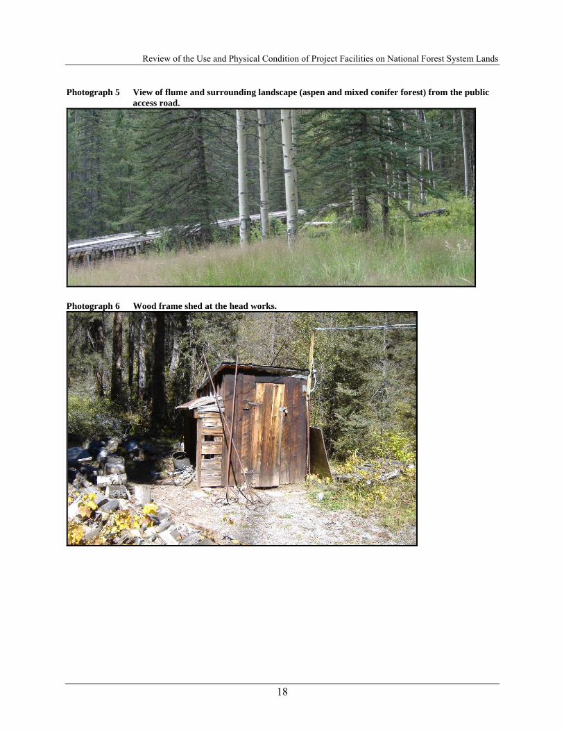
along the dirt access road that leads to the Project structures (barn and fenced yard) used for storage. The raised flume parallels Cascade Creek through the valley following the same terrain, and while the flume extends above the surrounding vegetated landscape in places, the wooden structure has weathered and merged visually with much of the natural character of the area. The Cascade Flume Head Works The Cascade Flume Head Works, consists of a dam, diversion structure, and a small equipment shed on the east side of Cascade Creek about 0.8 mile upstream of the crossing of the creek by U.S. Highway 550 (Photograph 1). The area is accessed by an unimproved USFS road 510 that runs northwesterly from Highway 550 just north of Cascade Creek. This road serves as access to several Tacoma hydro features, including the intake structure and flume, as well as the USFS Cascade Creek Summer Home Group (CCSHG). The dirt road leading up the northeast side of Cascade Creek ends on the hillside immediately east of the head works, from where a trail leads westward down to the facility on the edge of the creek. The head works is at an elevation of 8,920 feet (2,719 m) and covers 1,328 m2. Vegetation at the site includes spruce, Douglas fir, aspen, alder, willow, elderberry, currant, wild rose, and grasses. The head works is at a point on Cascade Creek where the southwest bank is constricted by a sheer rock outcrop. The diversion dam for the head works is anchored to the rock face, which has been faced with poured concrete to a height of about 12 feet (Photograph 2). This abutment wall extends downstream about 12 feet, whereupon it angles inward to the rock face. Upstream, the abutment wall angles to the rock face for about 6 feet, beginning at the upper face of the dam. The poured concrete dam is about 10 feet tall, 30 feet long, has a flat upstream face, and a downstream contour that is an ogee curve that extends about 10 feet downstream at its tail. About 20 feet from the southwest end of the dam is a 3-by-3-foot sluiceway opening at the bottom of the dam that is regulated by a steel lift gate in an iron frame (Photograph 3). At the diversion structure itself, the major components associated with the structure are constructed of concrete and stand in only minor contrast to the immediate surrounding landscape of exposed rock. When considered as part of the wider landscape, the thick ground-level vegetation and stands of aspen and pines provide natural screening and make the diversion structure virtually indiscernible from the primary public viewpoint on the bridge over the access road (Photograph 4). Generally, the structure is not readily visible until it is approached on foot (Photograph5). A 6-by-6-foot wood frame shed is about 30 feet north of the head works on the east bank of Cascade Creek (Photograph 6). It has vertical board and batten walls and a corrugated sheet metal and metal panel shed roof that slopes north. A door is on the center of the south elevation; there are no windows. The structure rests on an informal foundation of loose rock. A shed overhang has been added on the west side. It consists of a 4-by-6-foot framework that is open to the west. The south end is covered with horizontal 1-by-6-inch boards, and the north end is covered with iron sheet metal. Miscellaneous equipment is scattered around the structure from maintenance of the head works. About 12 feet south of the shed is a stone campfire ring; a stack of wood is southwest of the shed.

Review of the Use and Physical Condition of Project Facilities on National Forest System Lands
3
High Flume Road This unimproved road branches off the Cascade Creek access road (USFS 510) at the PSCo shed. It runs easterly and is used for accessing a couple of CCSHG cabins and a high trestle that supports the wooden flume (Photograph 7). Siphon The siphon entry structure is a concrete structure that connects the end of the wooden flume to the beginning of the pipe siphon, which conveys water across Cascade Creek to the pipeline portion of the Tacoma power plant water delivery system (Photograph 8). It is the original structure constructed in 1924. The siphon entry structure is on a moderately steep slope above and east of Cascade Creek. It is reached by a dirt road that runs eastward, uphill from the road up Cascade Creek just north of its junction with Highway 550. This unimproved road branches off the Cascade Creek access road (USFS 510) just west of Highway 550. It runs northeasterly and is used for accessing the Tacoma hydro wooden flume and siphon. The road is blocked by a cable and lock, along USFS 510, of which only PSCo and the Forest Service have access. The road passes just south of the siphon structure and then turns northward and runs above (east of) the structure along the wooden flume for a short distance. A small transmission line runs in a northwest to southeast direction just below the flume and the siphon entry structure. In addition to the siphon entry structure itself, a tin shed is situated just northeast, and a large wooden cover over the buried siphon pipeline is just southwest. A tin shed is about 14 feet northeast of the siphon entry structure (Photograph 9). It is a 6-by-8-foot wood-frame structure, oriented southwest to northeast, with a gable roof; the roof and sides of the shed are covered with corrugated sheet metal. It is set on 4-by-6-inch and 6-by-6-inch timbers resting on a loose rock foundation. A door is on the southeast end of the southwest side, facing the flume; there are no windows. Electrical wires lead into the structure, which is padlocked shut. The shed may have served as a gauging station or a station to record water flow into the siphon. The siphon section of the pipeline that starts at the end of the flume is set in the ground and above ground on NFS lands. The steel pipe is screened from typical public viewpoints, except, notably, for several locations along U.S. Highway 550 and the dirt access road to Cascade Creek Diversion Dam. Much of the siphon and pipeline mixes with and is screened by the surrounding landscape of mixed conifers, aspens and ground shrubs (Photograph 10) from the major public viewpoints. Where the structure is raised above the ground, the siphon is clearly visible (Photograph 11); however, the contrast with the surrounding landscape is minimal due to the dark (black) color of and background at the pipeline. According to the Historical Tacoma Survey Report, the head works, wooden flume, siphon intake structure, the portion of the siphon crossing Cascade Creek on a bridge, and the siphon outlet structure are visual elements of a functioning historical water delivery system. They have excellent historical integrity of setting and materials and readily demonstrate historical workmanship and design. Because the flume is of wooden construction, it fits well with the natural environment through which it passes and is a major asset to the historical feeling of the area. That the head works, flume, and siphon all have a strong historical and physical association with the Tacoma

Review of the Use and Physical Condition of Project Facilities on National Forest System Lands
4
Hydroelectric Project’s historic water delivery system is undeniable. Although the head works, flume, and siphon were not particularly unusual at the time of their construction, through attrition they have become unusual survivals representative of historical technology that has often been replaced by more modern structures and conveyances. The wooden shed at the head works is not considered to be an important element of the water delivery system and may not be of historic age. Maintenance Building The PSCo Maintenance Building, is a log cabin storage building just northeast of the intersection of the road up Cascade Creek and a road to the east that leads to several summer homes and the high trestle of the Cascade Flume (Photographs 12 to 14). The site covers 1,121 m2 at an elevation of 8,850 feet (2,697 m). It is on the edge of a spruce and aspen forest with an understory of grasses, dandelion, raspberry, and aster. The cabin is a 26½-by-41½-foot, 1½-story log structure, oriented generally north to south. The ends of the logs are not notched but are attached at the ends with 2-by-8-inch planks nailed together. The log walls are chinked with concrete and set on 8-by-8-inch beam sills; no foundation is evident. The structure has a corrugated sheet metal gable roof with exposed 2-by-6-inch board eaves. A corrugated pipe chimney projects through the north end of the west slope of the roof, just below the ridge. Large outward opening double doors fill a 16½-foot-wide opening centered on the south side of the building (Photograph 13). The doors are made of diagonal boards and have handmade hinges and a hand-forged bar and keeper closure. Hand-forged hooks are below the bar and keeper. Mounting hardware and electrical wire for a light fixture are above the door, above which is a single screened window opening in the gable. Two plain board doors are present on the north end of the structure. On the east elevation are two-light, fixed-wood sash windows on the south end, and a single-light, fixed-wood sash window with privacy glass is on the north end. All the doors and windows are trimmed with 2-by-8-inch boards. About 15 feet north of the log building is a 40-by-48-foot chain link enclosure (Photograph 15). It has no real gate, but fencing can be pulled back on the south end of the west side to gain access. Lumber and utility poles are contained within the enclosure. A considerable amount of 65-inch-diameter steel pipe, wire flume hoops, smaller pipe, corrugated sheet metal, and other maintenance materials are stored along the east side of the building. The maintenance building is recommended as not eligible for inclusion on the NRHP. Although the structure is of log construction, it is not a particularly good example of log architecture. The building is on the edge of the CCSHG, but is not a member of the group. It is not on a designated lot and was not built as part of the complex. It is compatible with the summer home group only in that it is of log construction. It is primarily a warehouse, and fronts very closely to the adjacent roads, rather than being set back like the homes in the group. Although the structure may be associated with the construction of the Cascade Flume and Siphon in 1924, no information about the building could be found in the Western Colorado Power Company records on file at the Center of Southwest Studies at Ft. Lewis College to confirm such a connection. Construction and maintenance materials behind the warehouse and in the adjacent fenced yard demonstrate its association with maintenance of the flume and pipeline, but that maintenance association is not sufficient for the warehouse to be considered important.

Review of the Use and Physical Condition of Project Facilities on National Forest System Lands
5
The log storage barn dominates the visual landscape, yet it is constructed of natural materials and colors and blends well with the surrounding forested landscape and similar Forest Service cabins in this area. The building’s weathered exterior (large log beams and rusted metal roof) presents an aged and darkened structure that is in character with its surroundings. The fenced outdoor storage area displays a disorderly and scattered appearance. The metal fence provides no screening and the scattered items—spare log beams, gravel piles and other miscellaneous construction materials—are in plain view and stand in contrast to the surrounding landscape of predominantly natural elements. 2.1.1 Assessment of Visual Contrast of Project Facilities in Cascade Creek Area Project Elements that Contribute to the Scenery and Landscape Setting The Cascade Creek Diversion Dam and associated facilities are located within the 2B Management Prescription Area. Emphasis is for rural and roaded-natural recreation opportunities. Visual resources are managed so that management activities maintain or improve the quality of recreation opportunities. Forest management activities should not be evident, remain visually subordinate, or may be dominant, but blend with the natural setting. Overall, the Project facilities located in this visual management area are evident, and with respect to the raised wooden flume and pipeline are even dominant at localized public viewpoints; however, in both instances the facilities “harmonize and blend with the natural setting” in compliance with the visual management direction for the area. The main storage barn also blends with the natural setting and is similar in appearance to the cabins/residences in the same area. Project Elements that may Detract from the Scenery and the Landscape Setting ■ The outdoor fenced storage area and the spare construction materials stand in contrast to the
overall landscape and do not blend well with the natural setting. ■ The miscellaneous non-essential construction and stockpiled items outside the shed at the
Cascade Creek Diversion Dam. Scenic Elements Consistent with the Desired Scenic Integrity ■ The Wooden Flume. Scenic Elements that are not Consistent with the Desired Scenic Integrity: ■ Storage area outside the PSCo log maintenance facility. ■ Miscellaneous, non-essential items located adjacent to the Cascade Creek Diversion shed. Recommendations to Protect or Enhance Significant Visual Resources ■ Contain maintenance items located within the chain-link fence at the PSCo log maintenance
barn; provide visual screening from storage yard. ■ Clean up miscellaneous non-essential items at Cascade Creek diversion shed.

Review of the Use and Physical Condition of Project Facilities on National Forest System Lands
6
■ Continue on-going maintenance to keep sheds and maintenance barns in good condition, and overall appearance (i.e., regular maintenance including roofing and painting).
2.2 Retired and New Gauging Station on Elbert Creek Retired Gauging Station Elbert Creek flows from the Hermosa Creek Palisades through a saddle in the Hermosa cliffs steeply down the drainage where it levels off as it crosses Highway 550. The creek meanders through a meadowland area before entering into Electra Lake. The gauging station is encased in a partially rusted metal cylinder at the creeks edge in a backwater section of the creek (Photograph 16). The old structure is set among the riparian vegetation and surrounded at its base by sediment and woody debris. The gauge structure is not readily visible from a trail along Elbert Creek. Once in view, it stands in contrast to the thick vegetation, creek and surrounding forest, specifically due to the color contrast of the gray metal case against a predominantly green landscape. The old gauge structure is extremely small and passive in the landscape, and even in close proximity to a viewer, is not dominant. New Gauging Station (1998) The new gauging station consists of a small metal Parshall flume, chart recorder enclosure, and a co-located steel lattice tower, antenna, solar panel and equipment enclosure (see Photographs 17 and 18). The gauge structure is not readily visible via public access from a trail along Elbert Creek. Once in view, it stands in contrast to the thick vegetation, creek and surrounding forest, specifically due to the color contrast of the gray metal case against a predominantly green landscape. The new gauge structure is small and passive in the landscape, and even in close proximity to a viewer, is not dominant. 2.3 Forebay Lake and Tacoma Penstock The Tacoma penstock consists of two distinct sections with Forebay Lake being the point of separation. The first section is a 66-inch-diameter, welded-steel pipeline constructed above ground extending from the outlet at Electra Lake 9,000 feet (half of which crosses NFS) to a bifurcation structure near Forebay Lake. This section of the penstock is supported by concrete thrust blocks and piers. The penstock runs through stands of aspen and mixed conifer trees as well as much of the low-lying ground vegetation between Electra Lake and Forebay Lake. Public access to this landscape primarily occurs along Forebay Lake Road access road leading from Terminal Dam at Electra Lake along that portion of the unimproved Forebay Lake access road located on NFS. The road extends southeasterly from Terminal Dam to where the penstock drops into the Animas River Canyon above the powerhouse. Approximately the south half of the penstock is located on NFS. It appears that the creation of the road was to support both the construction of the original flume and penstock. The road was closed by the USFS to motorized use a few years ago except for Project purposes and the occasional use by La Plata Rural Electric Association and the

Review of the Use and Physical Condition of Project Facilities on National Forest System Lands
7
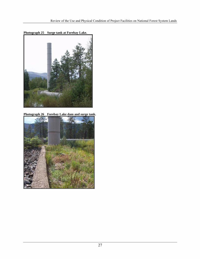
Colorado Division of Wildlife. The road is gated where it crosses onto NFS. This road is utilized for Project operations and by the FS for routine fire management (see Photograph 22). The penstock is not in view along much of the access road, but occasionally intersects or runs along the road. In these instances, the raised steel penstock, piers, and concrete thrust blocks appear in contrast to the surrounding landscape (Photographs 10 through 13). The second section of the Tacoma penstock starts at the bifurcation structure near Forebay Lake and consists of two welded-steel penstocks (54 and 30 inches in diameter) installed just below the ground level for 2,056 feet until they enter the Tacoma powerhouse. The only visible portion of the structure occurs at the canyon’s edge where the penstocks drop steeply down to the powerhouse. At this location, concrete thrust blocks and steel penstocks along with transmission lines are widely visible. The major penstock elements as well as ancillary structures are situated in a broad level area located east of Forebay Lake. At Forebay Lake, a 12-foot-diameter, 116-foot-high surge tank is installed at the aboveground (66-inch-diameter) penstock about 1,000 feet upstream of where the penstock splits and drops below ground and into the Animas River canyon. The structure stands starkly apart from the surrounding landscape in both color and form (Photographs 23 through 27). The lighter beige paint on the surge tank is in direct contrast to the largely darker green stands of trees and riparian vegetation that comprise the majority of the Forebay Lake visual landscape. Furthermore, the linear form of the surge tank extends vertically from the lake and towers above many of the trees where the surge tank rises from the penstock (Photograph 25). Forebay Lake itself is located downstream of Electra Lake with a small release of about 50 gallons per minute that has been released from the penstock into Forebay Lake since 1982, when Forebay Lake’s use as an integral part of operations was discontinued. Project facilities and structures at Forebay Lake include Forebay Dam, a concrete spillway and a gaging house. Forebay Dam is an earth and rock dam, roughly 100 feet long and 20 feet high. A low concrete overflow structure is located south of the dam. The earthen dam blends with the surrounding landscape and shoreline (Photograph 26). 2.3.1 Assessment of Visual Contrast in the Forebay Lake Area Project Elements that Contribute to the Scenery and Landscape Setting ■ The primary Project element contributing to the scenery and landscape setting is Forebay
Lake. Project Elements that may Detract from the Scenery and the Landscape Setting ■ The access road to Forebay Lake and the upper penstock are located in a 2A Management
Prescription Area and is not open to public motorized use. Emphasis is for semi-primitive motorized recreation opportunities. Visual resources are managed so that management activities are not evident or remain visually subordinate. The access road to Forebay Lake provides the main public non-motorized access and viewpoints of the Project facilities in this area. Along the majority of the access road to Forebay Lake, the Tacoma penstock is not
Review of the Use and Physical Condition of Project Facilities on National Forest System Lands
8
visible; however, at several locations, the penstock is visible, yet remains visually subordinate to the natural landscape (Photographs 19 and 20). At several other locations (Photographs 21 and 22), the penstock is highly visible and dominates the visual landscape (Figure 2-1). These areas are few, but at these locations, the facilities stand in contrast to the natural landscape and the visual management objectives for the area.
■ The penstock and surge tank structures at Forebay Lake, while hidden from view at times, become highly visible near Forebay Dam and adjacent shoreline of the lake. At these locations, the surge tank towers above the natural vegetation while the connecting penstock sits in front of the shoreline over the water and in front of the riparian vegetation. These Project features dominate the landscape at these locations.
Scenic Elements Consistent with the Desired Scenic Integrity ■ The primitive road is consistent as more of a non-motorized pathway, while Forebay Lake is
consistent with the desired scenic integrity of the landscape. Scenic Elements that are not Consistent with the Desired Scenic Integrity ■ The penstock is hidden and subordinate in some areas, yet quite visible and dominate in other
areas around Forebay Lake. The surge tank is a dominating structure. Recommendations to Protect or Enhance Significant Visual Resources ■ The penstock is a dominating feature, yet an interesting feature on the landscape.
Understanding these features as part of a historic project may help enhance a visitors understanding of the landscape and the historic nature of the Project facilities.
■ Maintain non-motorized access to enhance non-mechanized recreation opportunities, such as hiking and fishing at Forebay Lake.
■ Continue on-going maintenance of the area to remove trash. 2.4 Tacoma Powerhouse Area The 2.6-acre parcel of SJNF land on the west side of the river north of the power plant on which three residences and an animal shed are situated was inventoried. These buildings have historically been used in conjunction with the power plant, and the 2.6-acre parcel is being proposed for a land exchange from the FS to PSCo. The Tacoma power plant is part of a large complex that includes the power plant, four residential structures, a tram house, several outbuildings, the archaeological remains of several other structures, and a bridge across the Animas River from the Denver & Rio Grande Railroad (now operated as the Durango & Silverton Narrow Gauge Railroad). The railroad runs north to south through the site on the east side of the river and provides access to the power plant complex. The Tacoma power plant

Review of the Use and Physical Condition of Project Facilities on National Forest System Lands
9
Figure 2-1 Forebay penstock map.

Review of the Use and Physical Condition of Project Facilities on National Forest System Lands
10
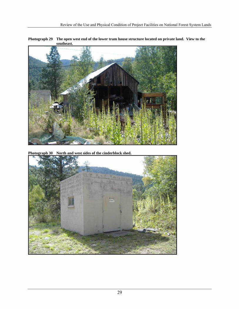
was initially recorded in 1979 by Grand River Institute (Alexander and Conner 1979). The majority of the site is on the private, patented Belmont Placer mining claim. However, several residences (Structures 6, 8, and 9), a fire protection valve house (Structure 7), and an animal shed (Structure 10) are on the SJNF. The portion of the site that was recorded covers 6.9 acres. It is situated at an average elevation of 7,320 feet (2,231 m) and is vegetated with spruce, Douglas fir, aspen, cottonwood, raspberry, elderberry, strawberry, willow, forbs, and grasses; the residential area is planted to lawn. Structure 1 - Tacoma Power Plant The Tacoma power plant (Structure 1) is the primary building of the complex. It is a large industrial building that measures 70 by 113 feet, oriented generally north to south on the west bank of the Animas River (Photograph 28). The building has a full concrete basement and is built on a poured concrete foundation. The full height of the foundation is visible on the east side of the power plant, where two arched sluiceways opening from the Pelton water wheels installed in 1905 on the north end and a rectangular sluiceway opening just south of center from the generating unit installed in 1949, allow water to drain from the structure directly into the Animas River. A decorative concrete water table band is present at the top of the foundation above which are the brick walls of the structure. The 46-foot-tall brick walls of the structure extend above the roof level to form a parapet wall. The concrete roof is slightly arched and water drains from the roof through pipes at each corner that exit through the lower walls. The transformer yard west of the power plant is contained within 75-by-90-foot and 40-by-45-foot chain-link fences. The yards are covered with gravel and contain modern transformers and electrical transmission poles that are the beginnings of transmission lines that run westward and northward. Originally, transformers and the beginning of the transmission lines were on the roof of the power plant. Structure 2 - Lower Tram House Structure 2 is the Lower Tram House for the tramway that ran from the power plant to Forebay Lake on the west rim of the Animas River Canyon (Photograph 29). The upper tram house has been obliterated, probably as a result of the 1980s replacement of the power plant penstock. None of the intervening tram towers have survived, either. The tram house measures 17½ by 19 feet, oriented north to south, with a 5-by-6-foot shed extension on the east side, 3½ feet from the northeast corner. The structure is of 8-by-8-inch post-and-beam construction with a gable roof. The exterior walls of the structure are vertical 1-by-10-inch boards, with the cracks covered with 1-by-4-inch battens. The roof is constructed of 4-by-6-inch plank rafters, with 1-by-10-inch board sheathing covered with galvanized sheet metal panels on the north slope and corrugated sheet metal on the south slope. The interior is floored with 2-by-12-inch planks set on 8-by-8-inch beam joists. A large, cast iron bracket is mounted near the east end of the floor that originally supported the bottom end of the shaft of the tramway bull wheel. The tram house is open to the west and has a 2-by-12-inch plank floor landing that extends 7 feet west of the opening. The structure has no windows. Heavy 8-by-8-inch beams that cross the interior at ceiling level are supported by 8-by-8-inch posts and 4-by-6-inch plank angle braces. These cross beams originally had tramway cable brackets mounted to them, but now support racks used to store lumber. A work bench has been built against the north wall, beneath

Review of the Use and Physical Condition of Project Facilities on National Forest System Lands
11
which is the electric motor that powered the tramway. The plate on the motor identifies it as a 25-horsepower induction motor manufactured by General Electric. The most recent patent number on the plate is 1902 and the motor has the number 178525. The electric motor was connected by a belt to a clutch/brake that transferred and regulated power to the bull wheel by way of another belt. The clutch/brake mechanism is mounted in the shed addition near the northeast corner of the structure. The bull wheel gave motion to a continuous wire rope traction line. Wheeled carriages with passenger cars below were pulled along a fixed wire rope static line by the traction. Some of the tramway equipment has been disposed of about 75 feet south of the tram house. Most prominent is the 8-foot-diameter cast iron bull wheel with a keyed hub for an 8-inch-diameter shaft. The bull wheel has a casting mark “D82.” Perhaps also a part of the tramway is a 32-inch-diameter pinyon gear on a 4-inch-diameter shaft with a bearing bracket still attached and a 12-inch-diameter cast iron pulley on a U shaped bracket with a mounting bolt. Two other pieces of hoisting equipment from the power plant are also discarded there. One is a pair of cast iron sheaves on a 2-inch-diameter shaft acting as a reduction mechanism from the overhead traveling chain hoist in the power plant. The mechanism is complete with chain guide arms and is painted yellow like the identical hoist currently in the plant. The other is a large geared hoist with a 12-inch-diameter drum for wire rope in a cast iron housing. This is on metal wheels and may have been an overhead traveling hoist. Structure 3 - Concrete Shed Structure 3 is a 10-by-10-foot cinderblock shed about 32 feet south of the power plant (Photograph 30). It is built on a concrete slab foundation and has a south sloping corrugated sheet metal shed roof. A door is in the center of the west elevation that has a 3½-by-4½-foot concrete landing. A two-light, fixed metal-sash window is in the center of the north elevation. Residential Area-West Side of Animas River (Photograph 31) Residential Area West is north of the power plant on the west side of the Animas River; it is mostly on the SJNF. It contains three residences (Structures 4, 5, and 6), a fire protection valve house (Structure 7), and an animal shed with attached fenced enclosure (Structure 8). The entire area from the power plant to the animal shed and from the top of the river bank to the base of the slope on the west is planted to grass, has several shade trees, and has old fashioned metal light poles throughout the area. There is a groomed lawn with a golf green and flag (see Photograph 31). Structure 4 - Residence Structure 4 is a one-story, wood-frame residence that measures 22 by 36 feet, oriented generally north to south, and has a 6-by-8-foot room (north-south axis) attached on the center of the west side (Photograph 32). The residence is built on a cinderblock foundation, has metal panel gable roofs, and is covered with horizontal wood-grained, manufactured panel siding over composition roll siding. The roof has open eaves, and a brick chimney projects through the roof near the center of the ridgeline on the east slope. The main entrance to the structure is through a door just south of center on the east elevation. Three steps lead up to a 4-by-6-foot concrete landing outside the door covered by a gabled projection extending from the house supported by wooden posts. A rear entry is in the

Review of the Use and Physical Condition of Project Facilities on National Forest System Lands
12
center of the west elevation, south of center on the small room. Like the front door, the rear entry is reached by three concrete steps onto a 4-by-4½-foot concrete landing and is covered by a gabled projection that is supported by wooden posts. A plank floor has been extended northward from the concrete landing, which has been enclosed on the north and west sides with horizontal board walls and covered by an extension of the north slope of the gabled porch roof. Fenestration is regular, being one over one, double-hung, wood sash windows. Individual windows are on either end of each elevation, and a smaller version is just right of the front door at the center of the east elevation. Structure 5 - Residence Structure 5 is a 10½-by-16-foot (north-south), one-story, wood-frame residence that appears to have been originally constructed as a work or animal shed (Photograph 33). The north half of the structure was the original shed. It measures 8 by 10 feet, oriented east to west, has horizontal clapboard siding, and a north-sloping, sheet metal shed roof. It is built on a post-and-beam foundation. The south half of the structure is an 8-by-10½-foot addition with a shallow south-sloping sheet metal shed roof. Horizontal pressed-board siding covers the walls of the addition and extends over the east side of the original portion of the structure. Entry to the structure is through a four-panel wooden door on the east end of the south elevation. A six-light, fixed wood-sash window is to the left of the door, and two four-light, fixed wood-sash windows fill the remainder of the south elevation. A group of three, four-light, fixed wood-sash windows are on the east side of the original wing (now the north end of the east elevation), and a group of four of the same-type windows are present on the south end of the east side. A group of three, two-light, fixed wood-sash windows are on the south end of the west elevation. All of the exterior windows appear to have been salvaged from elsewhere and expediently installed in the structure. The dividing wall between the two halves of the structure was the former south wall of the original shed. It has a wooden door with three horizontal panels below four glass lights on the east end and a six-light, fixed wood-sash window covering most of the west end. The northern original shed portion of the structure has a plywood floor and beaverboard walls, whereas the southern addition has a plank floor and sheetrock walls. Structure 6 - Residence Structure 6 is a 28-by-35½-foot, 1½-story, wood-frame residence, oriented east to west (Photograph 34). It is constructed on a concrete foundation and has a metal panel gable roof with open eaves and a brick chimney projecting near the ridge on the center of the south slope. Siding is horizontal wood-grained, manufactured panels. The main entry is on the south end of the east elevation. It has a wooden door with three horizontal panels below four glass lights and is covered with a screen door. A 4-by-6-foot concrete landing outside the door is reached by three concrete steps and is covered by a gable projection that is supported by wooden post brackets extending diagonally from the wall of the residence. An identical door, landing, and gable projection are present at the side entrance to the residence on the west end of the south elevation. A wooden deck has been added to the right of the main entry at the center of the east elevation. This measures 8 by 9 feet, oriented north to south, and consists of a plank floor on a post-and-board framework. Fenestration on the structure is regular, being six over one, double-hung, wood-sash windows. On the east elevation, two windows are regularly spaced near the center and on the north end one is situated in the gable. Three windows are regularly spaced on the north elevation, with the middle window being smaller in size, and two windows are regularly spaced on the west elevation with another window in the gable. On the south elevation, a pair of windows is to the right of the side

Review of the Use and Physical Condition of Project Facilities on National Forest System Lands
13
entry, and two other windows are regularly spaced at the center of the elevation and at the east end. Raspberries and flowers have been planted around the foundation of the house, and a barbecue and picnic table are in the yard. Structure 7 - Fire Protection Valve House Structure 7 is a fire protection valve house (Photograph 35). It is a 5½-by-5½-foot metal building that contains a water valve for fire protection. The structure is built on a concrete slab foundation and has a door left of center on its south side. It has no windows, but a small metal ventilating grate is high on the east side. Structure 8 - Animal Shed Structure 8 is a 10-by-22-foot (east-west axis), wood-frame animal shed on the northern end of the residential area (Photograph 36). It has vertical board walls built on 8-by-8-inch beam sills covered with vertical board siding. The corrugated sheet metal shed roof slopes to the south. Three corrugated fiberglass panels let light into the structure through the roof. Doorways are on the south ends of the east and west sides; it has no windows. Rabbit hutches are built into the southeast corner of the interior, and a feed bin is at the dividing wall inside. Another rabbit hutch is outside along the north wall of the shed. The shed is included in a 50-by-65-foot oval-shaped fenced enclosure; it forms the south side of the enclosure. The gate into the enclosure is at the southeast corner of the shed. The enclosure is made of steel T posts and woven-wire sheep fence. The remains of a 12-by-20-foot (east-west axis), irregularly-shaped, cement-lined pond are near the center of the enclosure. Structure 9 - Work Shed Structure 9 is an 8½-by-10-foot (northeast-southwest axis) wood-frame shed with vertical 1-by-12-inch board walls (Photograph 37). It has a corrugated sheet metal shed roof that slopes southwest, no windows, and a vertical board door on the center of the northeast side. The shed has a dirt floor and a wooden work bench built along the southeast wall. Structure 10 -Tacoma Power Plant Bridge A steel bridge running west to east across the Animas River connects the Tacoma power plant to the Denver & Rio Grande Railroad (now operated as the Durango & Silverton Narrow Gauge Railroad) (Photograph 38). It is a 150-foot-long, 10-foot-wide Warren truss bridge of a single span made of bolted and welded angle iron and I beams. Four I beam stringers support the wooden deck, which is made of 3-by-6-inch and 3-by-12-inch planks laid crosswise. Two rows of 2-by-6-inch boards run the length of the bridge as a travel surface. The deck is 16 feet above the river. Horizontal I beam cross braces are attached to the stringers every 11 feet and extend beyond the truss sides of the bridge; they serve as the base supports for braces angled inward to the top of the trusses. Angle iron crossing sway braces are attached below the stringers. The west abutment of the bridge is a concrete retaining wall extending northward along the bank of the river from the northeast corner of the power plant. The east end of the bridge is supported by a pair of 3-foot-diameter poured-concrete piers connected by horizontal and crossing sections of railroad rail. An identical pair of piers is near the center of the span on the east edge of the river. Angled wooden ramp entries are on both sides of the bridge. The ramp entry on the west side is 16 feet long and begins at a concrete apron outside

Review of the Use and Physical Condition of Project Facilities on National Forest System Lands
14
the north door of the power plant. The ramp entry on the east side is 37 feet long and is supported near its east end by a poured-concrete wall. Summary of the Visual Aspects of the Tacoma Powerhouse Area The entire area is able to be viewed from the river itself and across the river from the Durango and Silverton Narrow Gauge Railroad (D&SNGR) tracks along the Animas River (Photograph 28). From these two similar vantage points, the brick powerhouse and ancillary buildings are clearly visible and draw visual attention; however, the brick color of the powerhouse blends with the canyon walls that dominate much of the Animas River canyon downstream of the powerhouse (and even the waters of the Animas River). The area behind and slightly downstream of the powerhouse is used for surplus storage of construction and other Project-related materials. Generally, these areas and materials are not visible due to screening by the powerhouse or vegetation, except for a small area immediately adjacent to the downstream side of the powerhouse. In addition, both cabins at the powerhouse location are painted white with either gray or green metal roofs. While the predominant white color of both structures stands in contrast to the surrounding landscape, the older, simple structures have weathered and aged, presenting an antiquated-cabin appearance that tempers much of the tonal contrast to the surroundings (Photograph 28). Ancillary structures are found surrounding the cabins but present a similar antiquated appearance as the cabins and exist on a much smaller scale compared with the powerhouse and cabins. Behind the powerhouse, several unbounded areas are used for surplus storage, which lack any form of fencing and screening from the surrounding landscape. While some of these areas are visually unpleasing, they are not visible from the public viewpoints on the river and from the railroad as these areas are screened by the powerhouse and thick vegetation around the powerhouse. Several additional Project structures are located on the left (east) bank at the powerhouse location, where the D&SNGR tracks parallel the river. Four structures are present including one house, a large storage shed with an adjacent concrete pad, and two small sheds with hydrants. The house and large storage shed (with a concrete pad) are primarily white in color, while the small sheds (with hydrants) are painted brown. All of these structures are situated amidst a stand of pine trees. All four structures are situated near the railroad tracks across from the powerhouse and bridge. However, the two white structures are more visible from the public viewpoint at the bridge and stand in contrast to the surrounding treed landscape. The remaining two small shed structures are generally subordinate visually to the surrounding landscape as they are tucked among the other larger structures and their brown color blends with the surrounding terrain and tree cover. 2.4.1 Assessment of Visual Contrast at Tacoma Powerhouse Area Project Elements that Contribute to the scenery and Landscape Setting The Tacoma powerhouse and related Project facilities are located in a 3A Management Prescription Area. Management emphasis is for semi-primitive non-motorized recreation in both roaded and unroaded areas. Visual resources are managed so that management activities are not visually evident or remain visually subordinate. These Project facilities lie along the historic D&SNGR, which has been in continuous operation for over 123 years. The prescription applied to the corridor stresses Rural and Roaded Natural recreation opportunities while retaining or enhancing scenic values inherent in the naturally appearing landscape (USDA 1983, pg. J-24). The Tacoma powerhouse and

Review of the Use and Physical Condition of Project Facilities on National Forest System Lands
15
its ancillary cabins are historic structures of undetermined significance and thus may meet the FS visual management objective of retaining historic integrity along the D&SNGR corridor. Based on the results of the Tacoma Historic Properties Survey Report, the Tacoma power plant, was determined to be officially eligible for inclusion on the NRHP in 1980. Alpine’s 2006 work updates and greatly expands the recording of the site and includes all of the built elements present in the site complex. Elements that were determined should be considered contributing to the significance of the site were the Tacoma power plant; the Lower Tram House; a work shed; employee residences, located on SJNF managed lands; the animal shed; and the bridge across the Animas River. Project Elements that may Detract from the Scenery and the Landscape Setting Elements of the site not considered to be contributing to the significance of the site because they are relatively recent additions are four fire protection valve houses, the cinderblock shed, two prefabricated metal buildings, and bank stabilizing cribbing along the Animas River. Further, some debris that are not of historical significance behind the Tram Shed, and scattered behind the powerhouse may detract from the scenery and historic landscape setting. Additionally, the golf green with flag may detract from the scenery and historic landscape setting. Scenic Elements Consistent with the Desired Scenic Integrity The physical appearance of the power plant, other contributing structural elements of the site, and the bridge across the Animas River should be retained as much as is practical. Past maintenance has generally been compatible with the historical appearance of the structures and buildings, and future maintenance should continue to take into consideration their historic characteristics. In particular, brick repair at the exits of the drain pipes from the roof should be done to match the surrounding wall fabric and window repairs should match the originals. If major modifications are contemplated that would affect the appearance of the power plant or the other contributing elements of the site, a mitigation plan should be prepared and implemented that would include documentation to at least Athearn’s (1990) Level II standards. Scenic Elements that are not Consistent with the Desired Scenic Integrity The elements not consistent with the Desired Scenic Integrity most likely are those elements developed recently and excess debris of non-historic value. Recommendations to Protect or Enhance Significant Visual Resources ■ Clean up non-historic, non-essential trash piles behind sheds; ■ Provide visual screening for modern elements, paint with colors that blend into the
surrounding landscape (e.g., concrete shed painted in neutral tones); and ■ Store non-essential items such as grills and home amenities out of viewshed. P:\Xcel\132.0010\WP\0400-Recreation\Condition of Proj Fclts\T-Cndtns of ProjFclts-071009.doc KB/elt 132.0010.0400/8.0 October 9, 2007

Review of the Use and Physical Condition of Project Facilities on National Forest System Lands
16
Photograph 1 Public viewpoint of flume from the access road bridge (east).
Photograph 2 The diversion dam on Cascade Creek.

Review of the Use and Physical Condition of Project Facilities on National Forest System Lands
17
Photograph 3 Radial gate on the diversion channel just above the connection with the flume.
Photograph 4 Public viewpoint of flume and diversion structure (virtually indistinguishable) from the
access road bridge.
Review of the Use and Physical Condition of Project Facilities on National Forest System Lands
18
Photograph 5 View of flume and surrounding landscape (aspen and mixed conifer forest) from the public access road.
Photograph 6 Wood frame shed at the head works.

Review of the Use and Physical Condition of Project Facilities on National Forest System Lands
19
Photograph 7 The high trestle at a deep gulch crossing near the center of the flume.
Photograph 8 The wooden flume entering the siphon entry structure with the tin shed at the left. View to
the east-southeast.

Review of the Use and Physical Condition of Project Facilities on National Forest System Lands
20
Photograph 9 The siphon entry structure with the tin shed to the right. View to the south-southwest.
Photograph 10 View of Cascade Creek pipeline from public access road.

Review of the Use and Physical Condition of Project Facilities on National Forest System Lands
21
Photograph 11 View of Cascade Creek pipeline from public access road.
Photograph 12 West and south elevations of the Public Service Company maintenance building. View to the
north.

Review of the Use and Physical Condition of Project Facilities on National Forest System Lands
22
Photograph 13 Storage barn (front entrance view).
Photograph 14 Storage barn (back view of building).
Photograph 15 Fenced storage area.

Review of the Use and Physical Condition of Project Facilities on National Forest System Lands
23
Photograph 16 Retired Elbert Creek gauging station.
Photograph 17 Elbert Creek gauging station Parshall flume and chart recorder.

Review of the Use and Physical Condition of Project Facilities on National Forest System Lands
24
Photograph 18 Elbert Creek gauging station electronic equipment enclosures and communication tower.
Photograph 19 Low-lying section of penstock along access roads to Forebay Lake.

Review of the Use and Physical Condition of Project Facilities on National Forest System Lands
25
Photograph 20 Raised section of penstock along access road to Forebay Lake.
Photograph 21 Raised section of penstock crossing access road to Forebay Lake.
Photograph 22 Penstock parallels access road to Forebay Lake.

Review of the Use and Physical Condition of Project Facilities on National Forest System Lands
26
Photograph 23 Forebay Lake with Tacoma penstock.
Photograph 24 Forebay Lake with Tacoma Penstock.
Review of the Use and Physical Condition of Project Facilities on National Forest System Lands
27
Photograph 25 Surge tank at Forebay Lake.
Photograph 26 Forebay Lake dam and surge tank.

Review of the Use and Physical Condition of Project Facilities on National Forest System Lands
28
Photograph 27 Forebay Lake.
Photograph 28 Tacoma powerhouse view from across the river.
Review of the Use and Physical Condition of Project Facilities on National Forest System Lands
29
Photograph 29 The open west end of the lower tram house structure located on private land. View to the southeast.
Photograph 30 North and west sides of the cinderblock shed.

Review of the Use and Physical Condition of Project Facilities on National Forest System Lands
30
Photograph 31 View of Residential Area from the east side of the Animas River.
Photograph 32 South and east elevations of residence Structure 4.

Review of the Use and Physical Condition of Project Facilities on National Forest System Lands
31
Photograph 33 South and east sides of the converted Residence Structure 5.
Photograph 34 South and east elevations of Residence Structure 6.

Review of the Use and Physical Condition of Project Facilities on National Forest System Lands
32
Photograph 35 Structure 7 - Fire Protection Valve House
Photograph 36 Animal shed (Structure 8). View to the north.

Review of the Use and Physical Condition of Project Facilities on National Forest System Lands
33
Photograph 37 North and east sides of the work shed. View to the west.
Photograph 38 East approach to the bridge across the Animas River to the Tacoma power plant. View to
the west-northwest.