Review of the historical and existing - United States … · Review of the historical and existing...
87
Transcript of Review of the historical and existing - United States … · Review of the historical and existing...

Review of the historical and existingnatural environment and resource uses
on the Ottawa River.
Tim Haxton1 and Don Chubbuck2
Ontario Ministry of Natural ResourcesScience and Information Resources Division
Science and Information BranchSouthcentral Science and Information Section
SCSI Technical Report #119
1Ontario Ministry of Natural Resources, Southcentral Science and Information Section, Kemptville.2Ontario Power Generation, Technical Services, Toronto.

2002, Queen’s Printer for Ontario.Printed in Ontario, Canada.
MNR #51718(.3k P.R., 02-12-20)
ISBN #0-7794-3937-6 (print)ISBN #0-7794-3998-8 (electronic)
This report should be cited as:
Haxton, Tim and Don Chubbuck. 2002. Review of the historical and existing natural environment andresource uses on the Ottawa River. Ontario Ministry of Natural Resources, Science and InformationBranch, Southcentral Science and Information Section Technical Report #119. 76 p.
Copies of this publication are available free of charge from:Ontario Ministry of Natural Resources
Science and Information BranchSouthcentral Science and Information Section
3301 Trout Lake RoadNorth Bay, ON P1A 4L7
Phone (705) 475-5560FAX (705) 475-5570
Cette publication specialisée n’est disponible qu’en anglais.
AbstractThe Ottawa River is one of the magnificent water bodies in eastern Ontario. Sculpted 11,000 years ago bythe retreat of the Wisconsin glacier, its history is rich with exploration, discovery, transport and settle-ment. In the past 100 years, significant changes have occurred along the river altering it course, andtaming its wildness. The most significant changes have resulted from man harnessing some of the river’snatural power. Vast areas were flooded and natural rapids were eliminated as the river underwent hydro-electric development. Between the 1880’s and 1964, seven hydroelectric dams were constructed betweenCarillon and Lake Temiscaming. In this report, we review the historical conditions of this section of riverprior to hydroelectric development. This includes an array of historical aerial mosaics, archived photo-graphs and descriptions of predevelopment conditions and current views of existing structures. Inaddition, we review the existing environmental conditions in the various reaches including current hydrol-ogy, flora and fauna, significant species, parks, and environmentally sensitive areas along the river. Theintent of this report is to establish a reference document for the water manager to identify significantfeatures along the river and for the fisheries manager to assist in the understanding of past and currentinfluences to not only the fisheries of the river, but other associated biota.
RésuméLa rivière des Outaouais est un des plus magnifiques cours d’eau de l’Est de l’Ontario. C’est le recul duglacier du Wisconsin qui, il y a quelque 11 000 ans, a creusé son lit. Voie d’exploration, de découverte,de transport et de colonisation, elle connaît depuis une histoire riche. Les cent dernières années ont vudes transformations importantes, en particulier à la suite des activités humaines visant à capter l’énergiehydraulique naturelle de la rivière. Tout au long de son cours, certaines régions ont été submergées et desrapides naturels ont disparu dans le cadre de son aménagement hydroélectrique. De 1880 à 1964, septbarrages hydroélectriques ont été construits entre Carillon et le lac Témiscamingue. Le présent rapportexamine l’histoire de ce segment de la rivière avant son aménagement hydroélectrique. On y présente unemosaïque de photos aériennes historiques, de photos d’archives et de descriptions de l’état de la rivièreavant son aménagement, accompagnés de vues des ouvrages en place aujourd’hui. En outre, on y examinel’état actuel de l’environnement dans divers domaines, y compris l’hydrologie, la flore et la faune, lesespèces importantes, les parcs et les milieux écologiquement sensibles en bordure de la rivière. Le rapporta pour objet l’élaboration d’un document de référence qui permettra aux responsables de l’eau dereconnaître les caractéristiques marquantes des influences anciennes et actuelles, non seulement sur lespoissons de la rivière mais sur la biote qui est associée.
i

ii

iii
ContentsAbstract .................................................................................................................................................... iRésumé ....................................................................................................................................... iList of Tables ........................................................................................................................................... vList of Figures .......................................................................................................................................... vAcknowledgements ................................................................................................................................ viiIntroduction.............................................................................................................................................. 1Study objectives and scope ..................................................................................................................... 1Study area ............................................................................................................................................... 2Study approach ....................................................................................................................................... 3Overview ................................................................................................................................................. 3Lac Dollard des Ormeaux (Carillon to Chaudière Falls) ..................................................................... 4Pre-development description ................................................................................................................... 4Existing physical description ................................................................................................................... 7Present hydrology ................................................................................................................................... 9Chemical Characteristics ....................................................................................................................... 10Natural environment .............................................................................................................................. 11Fisheries................................................................................................................................................ 11Wildlife .................................................................................................................................................. 14Unique species ...................................................................................................................................... 17Wetlands, parks, and environmentally sensitive areas .......................................................................... 17Shoreline development .......................................................................................................................... 17Lac Deschênes (Chaudière Falls to Chats Fall/Fitzroy) .................................................................... 17Pre-development description ................................................................................................................. 17Existing physical description ................................................................................................................. 22Present hydrology ................................................................................................................................. 24Chemical characteristics ....................................................................................................................... 25Natural environment .............................................................................................................................. 25Fisheries................................................................................................................................................ 25Wildlife .................................................................................................................................................. 26Unique species ...................................................................................................................................... 27Wetlands, parks, and environmentally sensitive areas .......................................................................... 27Shoreline development .......................................................................................................................... 27Lac des Chats (Chats Falls/Fitzroy to Cheneaux Dam) .................................................................... 27Pre-development description ................................................................................................................. 27Existing physical description ................................................................................................................. 31Present hydrology ................................................................................................................................. 32Chemical characteristics ....................................................................................................................... 33Natural environment .............................................................................................................................. 33Fisheries................................................................................................................................................ 33Wildlife .................................................................................................................................................. 35Unique species ...................................................................................................................................... 36Wetlands, parks, and environmentally sensitive areas .......................................................................... 36Shoreline development .......................................................................................................................... 36Lac du Rocher Fendu (Cheneaux to La Passe Dam) ........................................................................ 36Pre-development description ................................................................................................................. 36Existing physical description ................................................................................................................. 37Present hydrology ................................................................................................................................. 40
iv
Chemical characteristics ...................................................................................................................... 41Natural environment ............................................................................................................................. 41Fisheries ............................................................................................................................................... 41Wildlife .................................................................................................................................................. 42Unique species ..................................................................................................................................... 42Wetlands, parks, and environmentally sensitive areas ......................................................................... 42Shoreline development ......................................................................................................................... 42Allumette Lake and Lac Coulonge (LaPasse to Des Joachims) ..................................................... 43Pre-development description ................................................................................................................ 43Existing physical description ................................................................................................................. 43Present hydrology ................................................................................................................................. 43Chemical characteristics....................................................................................................................... 43Natural environment ............................................................................................................................. 44Fisheries ............................................................................................................................................... 44Wildlife .................................................................................................................................................. 45Unique species ..................................................................................................................................... 45Wetlands, parks, and environmentally sensitive areas ......................................................................... 45Shoreline development ......................................................................................................................... 46Holden Lake (Des Joachims to Otto Holden Dam) .......................................................................... 46Pre-development description ................................................................................................................ 46Existing physical description ................................................................................................................. 49Present hydrology ................................................................................................................................. 51Chemical characteristics....................................................................................................................... 51Natural environment ............................................................................................................................. 51Fisheries ............................................................................................................................................... 51Wildlife .................................................................................................................................................. 52Wetlands, parks, and environmentally sensitive areas ......................................................................... 53Shoreline development ......................................................................................................................... 53Lac la Cave (Otto Holden Dam to the Dam at Lake Temiscaming) ................................................. 53Pre-development description ................................................................................................................ 53Existing physical description ................................................................................................................. 53Present hydrology ................................................................................................................................. 55Chemical characteristics....................................................................................................................... 57Natural environment ............................................................................................................................. 57Fisheries ............................................................................................................................................... 57Wildlife .................................................................................................................................................. 58Wetlands, parks, and environmentally sensitive areas ......................................................................... 58Shoreline development ......................................................................................................................... 58Summary ............................................................................................................................................. 58References .......................................................................................................................................... 59Appendix 1 .......................................................................................................................................... 64

v
List of TablesTable 1. Environmentally sensitive areas by river reach. ......................................................................... 5Table 2. Generating station characteristics. ............................................................................................ 9Table 3. Mean annual discharge (m3/s) of various tributaries of the Ottawa River. ............................... 10Table 4. Fish species by reach of the Ottawa River. ............................................................................. 13Table 5. Breeding bird species* by river reach. .................................................................................... 15Table 6. Amphibians and reptiles by river reach. .................................................................................. 18Table 7. Unique plant and wildlife species by river reach. .................................................................... 20Table 8. Wetlands by river reach. ......................................................................................................... 21Table 9. Environmentally sensitive areas by river reach. ...................................................................... 22Table 10. 1961 and 1996 populations by river reach. ............................................................................ 23Table 11. Mean percentage of land use class per tributary sub-basin of the Ottawa River. .................. 23
List of FiguresFigure 1. Reaches of the Ottawa River and locations of dams from Carillon to Lake Temiscaming. ....... 2Figure 2. Aerial photograph mosaic of the Ottawa River from Carillon to Hawkesbury illustrating theLong Sault, 1957. .................................................................................................................................... 6Figure 3. Carillon Rapids, 1983. .............................................................................................................. 6Figure 4. View of the Ottawa River from Grenville overlooking Greece’s Point prior to the construction ofCarillon Dam. .......................................................................................................................................... 6Figure 5. Old crib dam at the Carillon site. .............................................................................................. 7Figure 6. Carillon Dam during the spring flood of 1908. ........................................................................... 7Figure 7. Carillon rapids prior to the construction of the Carillon Dam. .................................................... 7Figure 8. The Carillon Generating Station observed from downstream on the west shore. ..................... 8Figure 9. Water surface profile of the Ottawa River. ................................................................................ 8Figure 10. Mean monthly water levels in Lac Dollard des Ormeaux since 1964. ................................... 11Figure 11. Total phosphorous levels at Hawkesbury (1970-2000). ........................................................ 11Figure 12. Biological Oxygen Demand at Hawkesbury (1970 - 2000). ................................................. 12Figure 13. The rock ledges of Chaudière Falls during low water in the 1870’s. ..................................... 24Figure 14. Chaudière Falls during high water in 1909. .......................................................................... 24Figure 15. A view of Chaudière Falls during the 1900’s. ........................................................................ 24Figure 16. Aerial view of Chaudière Falls in the mid 1900’s. ................................................................. 24Figure 17. Control dam at the head of Chaudière Falls (2000). ............................................................. 24Figure 18. Mean monthly water levels of Lac Deschênes over the past 50 years. ................................ 25Figure 19. 1927 aerial view of Chats Falls (National Air Photo Library). ................................................ 28Figure 20 Mohrs Chute and Horseshoe Chute prior to the construction of Chats Generating Station. .. 29Figure 21. Historical view of Ragged Chute at Chats Falls. ................................................................... 29Figure 22. An historical view of the log chute at Chats Falls. ................................................................. 30Figure 23. Aerial view of Chats Rapids and Chats Falls from upstream, 1920. ..................................... 30Figure 24. Aerial view of Chats Generating Station, July 1932. ............................................................. 31Figure 25. Chats Generating Station, 2000. .......................................................................................... 32Figure 26. Sluice gates and ancient waterway at Ragged Chute, 2000. ................................................ 32Figure 27. Sluice gates and structures at Horseshoe Chute, 2000. ....................................................... 32Figure 28. Sluice gates and ancient waterway at Conroy’s Chute, 2000. .............................................. 32Figure 29. Current view of log chute at Chats Falls, 2000. .................................................................... 32Figure 30. Mean monthly water levels of Lac des Chats over the past 50 years. .................................. 33Figure 31. Biological Oxygen Demand levels at Chats Falls (1966-2001). ........................................... 34Figure 32. Total phosphorous levels at Chats Falls (1966-2001). ......................................................... 35

vi
Figure 33. Rapids upstream of Portage du Fort bridge prior to the construction of Chenaux GeneratingStation . ................................................................................................................................................. 37Figure 34. Aerial mosaic of Lac du Rocher Fendu prior to the construction of the Chenaux GeneratingStation. .................................................................................................................................................. 38Figure 35. Historical view of the rapids where Chenaux Generating Station was constructed. View is fromthe east on Limerick Island. ................................................................................................................... 38Figure 36. The overflow channel constructed through Limerick Island (2000). ...................................... 38Figure 37. Limerick Island control structure (2000). ............................................................................... 39Figure 38. Cheneaux Generating Station (2000). .................................................................................. 39Figure 39. The dam constructed at Portage du Fort (2000). .................................................................. 39Figure 40. Bryson Dam (1997). ............................................................................................................. 39Figure 41. Mean monthly water levels in Lac du Rocher Fendu over the past 50 years. ....................... 40Figure 42. Biological Oxygen Demand levels at Chenaux, 1968 - 2000. .............................................. 41Figure 43. Total phosphorous levels at Chenaux, 1968 - 2000. ............................................................. 42Figure 44. Mean monthly water levels in Allumette Lake over the past 50 years. .................................. 44Figure 45. Aerial mosaic of the Ottawa River upstream of Des Joachims to Bissett Creekpre-hydroelectric development (1946). .................................................................................................. 47Figure 46. Aerial view of rapids des Joachims from downstream, 1925. .............................................. 47Figure 47. Historical view of the upstream rapids at Rapids des Joachims, 1947 ................................ 48Figure 48. Historical view of the downstream rapids at Rapids des Joachims, 1947. .......................... 48Figure 49. Aerial view of the Rapides-des-Deux-Rivières, 1946. .......................................................... 49Figure 50. Historical view from the foot of Deux Rivières rapids pre-hydroelectric development. ......... 50Figure 51. McConnell Lake Dam (2000). .............................................................................................. 50Figure 52. Des Joachims Dam and tailrace channel (1997). ................................................................ 50Figure 53. Swift current in the tailrace of Des Joachims Dam (2000). .................................................. 51Figure 54. View of the lower rapids of Rapids des Joachims from the bridge, 1906. ............................ 51Figure 55. Mean monthly water levels in Holden Lake over the past 50 years. .................................... 52Figure 56. Aerial view of the La Cave Rapids prior to the construction of the Otto Holden Dam. .......... 54Figure 57. La Cave Rapids, 1948, site of the Otto Holden Dam. .......................................................... 55Figure 58. View of the substrate of La Cave Rapids during the construction of theOtto Holden Dam, 1950. ....................................................................................................................... 55Figure 59. Aerial view of La Cave rapids during the construction of the bypass channel, 1949. ........... 55Figure 60. Otto Holden Dam (2000). ..................................................................................................... 55Figure 61. Mean monthly water levels in Lac la Cave over the past 50 years. ...................................... 56Figure 62. Biological Oxygen Demand levels at Otto Holden Dam, 1968 - 1994. ................................. 56Figure 63. Total phosphorous levels at Otto Holden Dam, 1968 - 1994. ............................................... 57

AcknowledgementsWe are indebted to many people that assisted with the collation of historical and current information forthis report. We would like to thank Al Headon, retired Corrosion Specialist from Ontario Hydro, for hisassistance with obtaining historical photographs and documents; Suzanne Guertin of Pembroke for herassistance in arranging historical and current aerial photographs; Toni Mirizzi of the Information Centrein Toronto for assisting with historical aerial photographs; Al Bibby of Kemptville for his GIS work andassistance with historical mosaics; Tina Watts of Hydro One Archives; Marie-Josée Deshênes of Hydro-Québec archives; Ron Threader and Liisa Blimske of Ontario Power Generation for their involvement inthe initial stages of this report; and the reviewers of this document including Don Ferko and Greg Pope ofOntario Power Generation and David Critchlow, Anne Bendig, Stephen Belfry, and Tania Baker of theOntario Ministry of Natural Resources.
Finally, we would like to thank Lyn Thompson of Southcentral Science and Information in North Bay forediting, formating, and publishing this document.
vii

viii
Review of the historical and existing natural environment and resource uses on the Ottawa River.
IntroductionThe mighty Ottawa River, historically known asKichesippi (the Great River). It is the largest allCanadian river in eastern Canada, flowing throughthe nation’s capital with as much history as it haspower. At one time considered to be the gatewayto the east, it was the route of Samuel deChamplain’s explorations, the travel corridor ofthe Voyageurs. This river became the highway ofthe fur trade and later, the main artery for trans-porting logs to European markets. It aided thecolonization of a great country to such an extentthat the nation’s capital was built on its shores.Historically, dams and canals were constructedalong sections of the river either to harness itspower or avoid the power of its countless falls andrapids. However, it was in 1943, when the Ontarioand Québec governments signed an agreement toallocate between them the undeveloped waterpower sites on the Ottawa River (Ottawa RiverEngineering Board 1965; Hincks 1978), that thegreatest changes would result along its course.
The Ottawa River took its shape approximately11,000 years ago with the retreat of the Wisconsinglacier. For thousands of years, it sculpted theOttawa Valley (Chapman and Putnam 1984). TheChamplain Sea, a marine environment, onceflooded the valley as far upstream as Point Alexan-der (Barnett 1989). Hence, colonization by fishcame primarily from the Mississippian refugium,from the Great Lakes via the Fosmill Outlet andlater via the Mattawa Outlet, although somespecies arrived from the Atlantic Coastal Plain(McAllister and Coad 1974). After the retreat ofthe glacier, the course of the Ottawa River re-mained relatively unchanged until the 20thCentury.
The Ottawa River flows for approximately 1,130kilometres (km), from its origins at LakeCapitmitchigama in Québec to the confluence atthe St. Lawrence River (Legget 1975), and has avertical descent over its course of 365 metres (m)(Telmer 1996). The Ottawa River itself is a tribu-
tary representing approximately 11.2 percent (%)of the total drainage area of the St. Lawrence(Telmer 1996). It forms a natural provincial borderbetween Ontario and Québec for approximately580 km from Lake Temiscaming to Carillon(Chapman and Putnam 1984). The watershed isapproximately 146,000 kilometres square (km2 ), ofwhich 65% is within the province of Québec(Telmer 1996). The mean annual flow of theOttawa River is 1,968 cubic metres per second(m3/s) (Telmer 1996).
There are numerous tributaries of the OttawaRiver, which are listed when describing eachsection of the report, many of which have alsobeen dammed. Currently, there are 43 dams withinthe watershed, seven of which are on the maincourse of the river (Environment Canada et al.1985), forming more than 14 billion metres cubed(m3) of water storage capacity (Ottawa RiverRegulation Planning Board 1984). Regulation ofthe river commenced early in history, as evident bythe reduction in the ratio of maximum to minimumflow from about 10:1 in 1870, to 5:1 by 1930(Legget 1975). All of the dams and reservoirs inthe Ottawa River basin make it one of the mosthighly regulated catchments in Canada (Telmer1996).
Study objectives and scope
Objectives
The purpose of this report is to provide a compre-hensive reference document that illustrates thehistorical and existing state of the environment ofthe Ottawa River. The objective of this report is toreview the environmental and resource uses of theOttawa River. This includes a review of the physi-cal conditions of the river prior and afterhydroelectric development in various reaches ofthe river; describing the present hydrology (includ-ing current water management regimes); chemicalcharacteristics; associated biota; wetlands andsignificant areas (ANSI and RPF1) along each
1
1 ANSI = Area of Natural and Scientific Interest; RPF = reserve ecologique.
Review of the historical and existing natural environment and resource uses on the Ottawa River.
reach; and shoreline development. This report isintended to be a reference document for the watermanager to identify the significant features alongthe river, and/or to assist the fisheries manager inunderstanding past and current influences to notonly the fisheries of the river, but other associatedbiota.
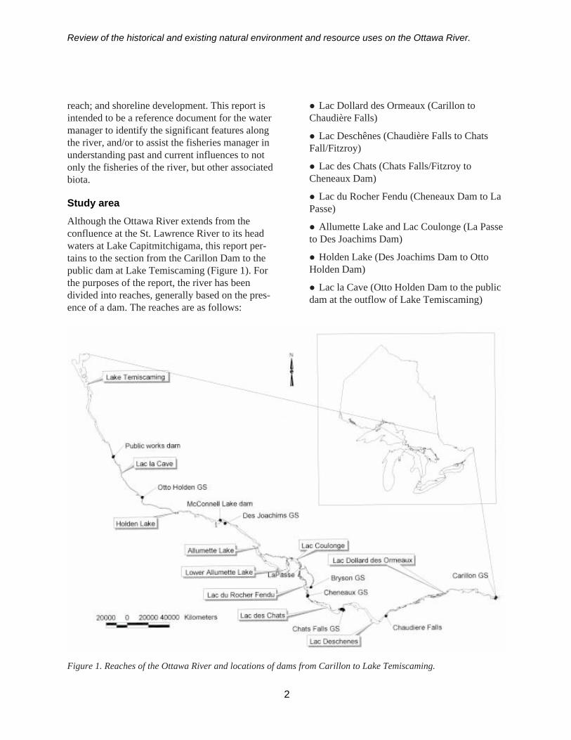
Study areaAlthough the Ottawa River extends from theconfluence at the St. Lawrence River to its headwaters at Lake Capitmitchigama, this report per-tains to the section from the Carillon Dam to thepublic dam at Lake Temiscaming (Figure 1). Forthe purposes of the report, the river has beendivided into reaches, generally based on the pres-ence of a dam. The reaches are as follows:
� Lac Dollard des Ormeaux (Carillon toChaudière Falls)
� Lac Deschênes (Chaudière Falls to ChatsFall/Fitzroy)
� Lac des Chats (Chats Falls/Fitzroy toCheneaux Dam)
� Lac du Rocher Fendu (Cheneaux Dam to LaPasse)
� Allumette Lake and Lac Coulonge (La Passeto Des Joachims Dam)
� Holden Lake (Des Joachims Dam to OttoHolden Dam)
� Lac la Cave (Otto Holden Dam to the publicdam at the outflow of Lake Temiscaming)
2
Figure 1. Reaches of the Ottawa River and locations of dams from Carillon to Lake Temiscaming.
Review of the historical and existing natural environment and resource uses on the Ottawa River.
This report describes each section travellingupstream from Carillon. The reason for this ap-proach is to describe the control structure for thereach, if one is present, and then describe theimpoundment. In addition, using the historicalinformation, it recreates the obstacles that earlyexplorers encountered on their travels up the river.
Study approach
This study was conducted in several phases. Thehistorical review included reviewing all documentspertinent to the Ottawa River, specifically thosethat detailed conditions prior to the construction ofthe hydroelectric dams. Libraries, bookshops,archives and journals were searched for relevantinformation. Historical photographs were obtainedfrom the National Air Photo Library, NationalArchives of Canada, Hydro One Archives, Hydro-Québec Archives, and the Ontario Ministry ofNatural Resources Information Centre.
The present hydrology was obtained from theOttawa River Regulation Planning Board, OntarioPower Generation (OPG) and Hydro-Québec.
The remainder of the data on sensitive species andareas, fisheries, wildlife, and chemical characteris-tics were obtained from the various managingagencies such as the Ontario Ministry of NaturalResources (OMNR), Société de la Faune et desParcs du Québec, as well as a 1993 field reconnais-sance by OPG staff. The intent of this document isto offer general descriptions of what is found ineach reach. More detailed descriptions and map-ping, specifically on sensitive species, can beobtained from the sources identified.
OverviewOriginating in a chain of lakes in Québec, GrandLac Victoria, and Reservoir Dozois, the OttawaRiver winds its way westward through ReservoirDecelles, Lac Simard and Lac Des Quinze beforeflowing southward into long narrow LakeTemiscaming. Here the river emerges from amixed forest of balsam fir, black spruce, and aspen(in the Missinaibi-Calonga section of the Boreal
Forest Region) into a settled area of agricultural,mining, and lumbering interests (in the HaileyburyClay and Temagami sections of the Great LakesForest Region) (Rowe 1972).
At the southern end of Lake Temiscaming, theriver plunges back into a transitional forest (theAlgonquin-Pontiac section of the Great Lakes-St.Lawrence Forest Region) running generally south-eastward past the towns of Mattawa and DeuxRivières. The banks of the river are steep androcky in nature. Approaching the town ofPembroke, the river widens out around AllumetteIsland with forest giving way to agricultural landson a sand plain (a delta formed in the ChamplainSea by rivers such as the Petawawa and Ottawa)interspersed with Precambrian rock outcrops alongthe lowlands of the Ottawa Valley (the OttawaValley Clay Plains of Lake Algonquin) (Chapmanand Putnam 1984). Leaving Pembroke, the riverwidens and there are a number of lake-likestretches broken by the rapids at Île du GrandCalumet as the river flows toward the city ofOttawa. Along this section of the river the forestbecomes more deciduous in composition, beingdominated by maples, beech, birch, and oaks (theUpper St. Lawrence Section of the Great Lakes-St.Lawrence Forest Region).
The diversity and distribution of fish and wildlifespecies have been affected by development of theOttawa River, in particular, hydro-electric genera-tion. The dams have blocked migratory species,such as American shad and eels, to the degree thatthey are very low in numbers or absent from theOttawa River. There are eighty-five fish speciesdocumented to inhabit the Ottawa River (Appendix1). The river redhorse, a provincially rare species,is present in various reaches and tributaries of theriver. The Ottawa River provides a recreationalresource primarily for sport fishing, hunting andboating. Sport fish in the area include muskellunge,largemouth bass, walleye, northern pike,smallmouth bass, and yellow perch. The waterquality and thus the fishery in the Ottawa River areconsidered to be better than 30 years ago due to
3
Review of the historical and existing natural environment and resource uses on the Ottawa River.
regulations on industrial effluents and the eventualdecline of log drives on the river.
The Ottawa River system has a great diversity ofhabitats supporting wildlife, birds and plant com-munities. Over 300 bird species inhabit the studyarea (Sankey 1987). As evidence of this diversity,the Ontario Ministry of Natural Resources andSociété de la Faune et des Parcs du Québec (SFEP)have established a number of parks, Areas ofNatural and Scientific Interest (ANSI) and ecologi-cal reserves (RPF) within the study (Table 1)(Chabot 1992; OMNR 2001a).
Changes in habitat, due to hydro-electric develop-ment, has had its impact on wildlife habitat. Theloss of historic mud flats and creation of newhabitat has affected shorebird populations (Sankey1987). Yet flooding has created wetlands for otherbirds such as waterfowl (Munro 1967). The OttawaRiver is considered to be most important as awaterfowl flyway during migration especially fornorthern species, e.g. brant, arctic terns, and red-throated loons (McKeating 1990). Waterfowlnesting occurs within floodplain wetlands locatedwithin or adjacent to the river (protected by beaverdams or barrier beaches).
Yet, the diversity and distribution of bird specieshas also been affected by other factors related tothe “development of the river”. Birdwatching in theupper Ottawa River Valley was first mentioned in1889, in an article “The Birds of Renfrew County”by Rev. C.J. Young who wrote:
“The grown people who have spare time, don’ttrouble themselves at all about the birds ... Ihear of birds being shot at all seasons for noearthly purpose whatever ... in the part ofOntario where I live [the birds] are yearlydiminishing.”
Thus, even before the advent of hydroelectricgeneration, species such as raptors (e.g. breedinggolden eagles) and migrating waterfowl weredecreasing in number and variety (Sankey 1987).
Although much of the southern reach of the OttawaRiver is privately owned, the northern section of
the river is Crown land. The development of theOttawa River has affected resource users in thesereaches of the river. Water resource users such asnative people, canoeists, hunters, and fishermen,who prefer a pristine, undisturbed setting may bemore affected by development. Other users whoprefer cottaging and other lake-oriented recreationsmay be less affected by development such ashydroelectric development.
Lac Dollard des Ormeaux (Carillon to ChaudièreFalls)
Pre-development descriptionHistorically, the first major set of rapids encoun-tered when traveling up the Ottawa River from Lacdes Deux Montagnes was the Long Sault, whichcomprised three main sets of rapids: CarillonRapids, Chute à Blondeau, and Long Sault Rapids(Figure 2). This was a 20.9 km section that cas-caded approximately 18.3 m in elevation fromGrenville to Carillon (Lambart and Rigby 1963).
The Carillon Rapids were the lowest set of rapidsof the three in the Long Sault. These rapids weredescribed by an engineer in 1860:
“At Carillon, the river is obstructed 1.3 milesby a reef of calciferous sandstone with onlytwo to three feet of water running over it,except in the ‘sickle channel’, about 150 feetwide and nine or ten feet deep and, as its nameimplies, very crooked” (Lambart and Rigby1963).
The fall at the Carillon Rapids was 2.7 m and thecurrent was very strong (Figure 3) (Lambart andRigby 1963). The next set of rapids, Chute àBlondeau (“The Chute”) was located shortlyupstream and was a narrow channel cut through arock shelf to a depth of 4.0 m (Lambart and Rigby1963). This set of rapids was relatively short andhad a fall of about 1.2 m (Legget 1975). Shortlyupstream, the Long Sault rapids were encountered.These rapids were comprised of five or six smallerrapids (Lambart and Rigby 1963), extending formore than 9.7 km between Grenville and Greece’sPoint (Figure 4) with a drop of approximately 14 m
4

Review of the historical and existing natural environment and resource uses on the Ottawa River.
5
noitceSreviR aerAevitisneSyllatnemnorivnE
xuaemrOseddralloDcaL ecnasialPednoitavresnoCedcraP
ISNAecneicShtraEkraPlaicnivorPruegayoV
ISNAecneicShtraEnaibmacerPdnalkcoR
ISNAecneicSefiLetadidnaCsdnalsIeniatnofaLeiaB
ISNAecneicSefiLetadidnaCdnalteWdnalsIeirteP
ISNAecneicSefiLaerAnoitavresnoCkeerCneerG
ISNAecneicSefiLetadidnaCsdnalsIkcuD
senêhcseDcaL ISNAecneicSefiLetadidnaCaerAnoitavresnoCainnatirB
ISNAecneicShtraEetadidnaCdnalteWhcaeBawattO
ISNAecneicShtraEdnalteWyaBs'yelrihS
ISNAecneicSefiLdnalteWkeerCecnatsnoC
ISNAecneicSefiLetadidnaCserohSyaBeohsesroH
ISNAecneicShtraEsllihdnaSyaBecnatsnoC
kraPlaicnivorPyorztiF
stahCsedcaL ISNAecneicSefiLdnalteWeynSippississiM
ISNAecneicSefiLaerAnoitavresnoCdnalsIsirroM
lotsirBedeuqinuaFegufeRudtejorP
udneFrehcoRudcaL kraPyawretaWlaicnivorP
egnoluoCcaLdnaekaLettemullA ISNAecneicShtraEselohepiPessaPaL
ISNAecneicSefiLecarreTawawateP
*FPRneidnI'leduaessiuR
FPRelttiLsemaJ
FPRehcnalBetêTàelgiA'leD
ekaLnedloH FPRuaetniLérdnA
kraPlaicnivorPyaBdoowtfirD
evaCalcaL ISNAecneicSefiLtseroFekaLrednaxelA
ISNAecneicShtraEreviRawattO/okcoJ
ISNAecneicSefiLsworraNnotloC
ISNAecneicSefiLtnioPeerteniP
ehtnevigsieuqigoloceevreserA.euqigoloceevreseredtcejorpdetangisedcebeuQasiFPR*cebeuQninoitcetorpfoleveltsehgih
1002PEFS;a1002RNMOecruoS
Table 1. Environmentally sensitive areas by river reach.

Review of the historical and existing natural environment and resource uses on the Ottawa River.
(Lambart and Rigby 1963; Lafrenière 1984). Thenatural variation in the water level that occurred atthese rapids was generally between 2.1 and 2.4 m,but occasionally reached 4.6 m (Lambart andRigby 1963). Large rocks were prevalent in theserapids (Lafrenière 1984).
The Long Sault was an obstacle for early naviga-tion, sometimes requiring several days to ascend(Lambart and Rigby 1963). To make passageeasier, canals were constructed to bypass theCarillon Rapids, Chute à Blondeau and Long SaultRapids. The primary reason for the construction ofthese canals was to establish a travel corridor intoCanada that was located away from the St. Law-rence in case of war with the United States(Lambart and Rigby 1963). The construction of thecanals officially started in 1819, however, excava-tion did not actually take place until 1821. Threecanals were finally opened in 1834 (Legget 1975).Carillon Canal was 4.7 km in length and containedthree locks; the Chute à Blondeau canal was 0.26km in length and contained one lock; and theGrenville Canal was 9.3 km in length and con-tained seven locks (Lambart and Rigby 1963). Thissystem was upgraded in the 1870’s to 1880’s andincluded the construction of the first dam atCarillon (Lafrenière 1984). It was a rock-filled cribdam constructed in 1870 by the Department ofPublic Works (Figure 5), intended to assist loggingoperations on the river (Legget 1975). The dam
6
Figure 2. Aerial photograph mosaic of the Ottawa River from Carillon to Hawkesbury illustrating the Long Sault,1957.
Figure 4. View of the Ottawa River from Grenvilleoverlooking Greece’s Point prior to the construction ofCarillon Dam (Quebec Hydro Archives ).
Figure 3. Carillon Rapids, 1983 (National Archives ofCanada PA 85631).

Review of the historical and existing natural environment and resource uses on the Ottawa River.
extended 549 m across the river and contained alog slide 67 m wide and 168 m long to permit thepassage of timber rafts (Lafrenière 1984). The damraised the water level 2 m (Lambart and Rigby1963), flooding the slight rise in the single lock ofChute à Blondeau (Legget 1975) and submersingthe Chute à Blondeau rapids (Lafrenière 1984).The construction of the dam permitted water toflow over top of the structure (Figure 2 and 6). Asa result of the dam, the current at Carillon wasgentle (Figure 7; Lambart and Rigby 1963). Theupgraded canals were opened in 1882 (Lafrenière1984). Figure 2 illustrates the canals at Grenvilleand Carillon prior to the construction of theCarillon Dam by Hydro-Québec.
Existing physical descriptionThe Carillon Generating Station (GS) was con-structed at the site of the old dam to supply hydroto the Montreal area during peak hours (Lafrenière1984). The dam was constructed between 1959 and1963, and was operational by 1964 (Legget 1975;Lafreniere 1984; Hydro-Québec 1996). TheCarillon Dam is 1,128 m long, 19.8 m wide and16.8 m high (Figure 8; Lafrenière 1984). Thegenerating station has 14 units that are operational(Legget 1975; Hydro-Québec 1996). A 7.6 m highdyke was constructed on each side of the upstreamportion of the dam (Lafrenière 1984). The dyke on
7
Figure 5. Old crib dam at the Carillon site (QuebecHydro Archives).
Figure 7. Carillon rapids prior to the construction of the Carillon Dam (Hydro-Quebec Archives).
Figure 6. Carillon Dam during the spring flood of 1908(National Archives of Canada PA 85631).

Review of the historical and existing natural environment and resource uses on the Ottawa River.
Figure 9. Water surface profile of the Ottawa River(Ottawa Engineering Board 1965).
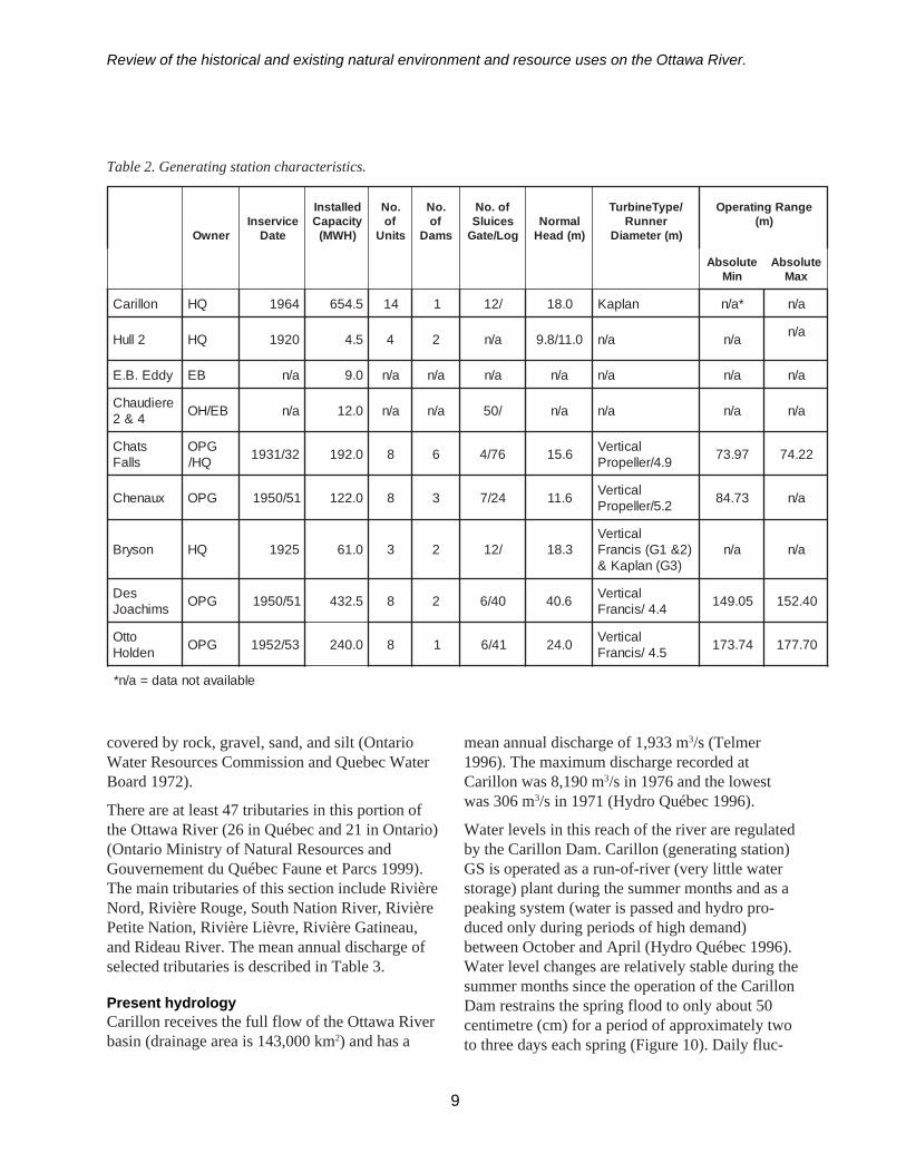
the left side of the dam is 4.5 km and on the rightside, 1 km (Hydro-Québec 1996). There is anoperational lock on the north side of the dam thatallows the movement of boat traffic up and downthe river. Additional features of the Carillon Damare outlined in Table 2. In this reach of river, thewater levels rose an average of 1.8 m over adistance of 96.6 km (Munro 1967) flooding outChute à Blondeau and Long Sault rapids (Lambartand Rigby 1963; Lafrenière 1984). Water levelsrose 18.9 m at Carillon, 2.7 m at Grenville and 0.9 mat Masson (Lafrenière 1984). A water surfaceprofile of the Ottawa River (Figure 9) illustratesthe extent of changes that occurred in this sectionof the river as a result of the construction of thedam. Despite the rise in the water levels, there wasa relatively small area flooded (Efford 1975).
Lac Dollard des Ormeaux is the reach of riverbetween the Carillon Dam and Chaudière Falls. Ithas a length2 of approximately 113.1 km and asurface area of 14,414 ha. This portion of the riverconsists of a main channel and a large floodplain.There are no rapids or fast water, however, there isa strong current present throughout most of thereach. Water depths may reach 95 to 100 m in themain channel but probably average from 6 to 8 m.
The north shore (Québec) of the river consistsmostly of shallow bays (Ontario Ministry ofNatural Resources and Gouvernement du QuébecFaune et Parcs 1999). Generally, the southern
8
Figure 8. The Carillon Generating Station observedfrom downstream on the west shore.
shoreline (Ontario) has much less littoral habitatand is characterized by a relatively steep slopingchannel. The river bottom in this reach is mainly
2 Length was calculated by measuring the midline of the river between designated points.
Review of the historical and existing natural environment and resource uses on the Ottawa River.
9
Table 2. Generating station characteristics.
renwOecivresnI
etaD
dellatsnIyticapaC)HWM(
.oNfo
stinU
.oNfo
smaD
fo.oNseciulSgoL/etaG
lamroN)m(daeH
/epyTenibruTrennuR
)m(retemaiD
egnaRgnitarepO)m(
etulosbAniM
etulosbAxaM
nolliraC QH 4691 5.456 41 1 /21 0.81 nalpaK *a/n a/n
2lluH QH 0291 5.4 4 2 a/n 0.11/8.9 a/n a/n a/n
yddE.B.E BE a/n 0.9 a/n a/n a/n a/n a/n a/n a/n
ereiduahC4&2 BE/HO a/n 0.21 a/n a/n /05 a/n a/n a/n a/n
stahCsllaF
GPOQH/ 23/1391 0.291 8 6 67/4 6.51 lacitreV
9.4/relleporP 79.37 22.47
xuanehC GPO 15/0591 0.221 8 3 42/7 6.11 lacitreV2.5/relleporP 37.48 a/n
nosyrB QH 5291 0.16 3 2 /21 3.81lacitreV
)2&1G(sicnarF)3G(nalpaK&
a/n a/n
seDsmihcaoJ GPO 15/0591 5.234 8 2 04/6 6.04 lacitreV
4.4/sicnarF 50.941 04.251
ottOnedloH GPO 35/2591 0.042 8 1 14/6 0.42 lacitreV
5.4/sicnarF 47.371 07.771
elbaliavatonatad=a/n*
covered by rock, gravel, sand, and silt (OntarioWater Resources Commission and Quebec WaterBoard 1972).
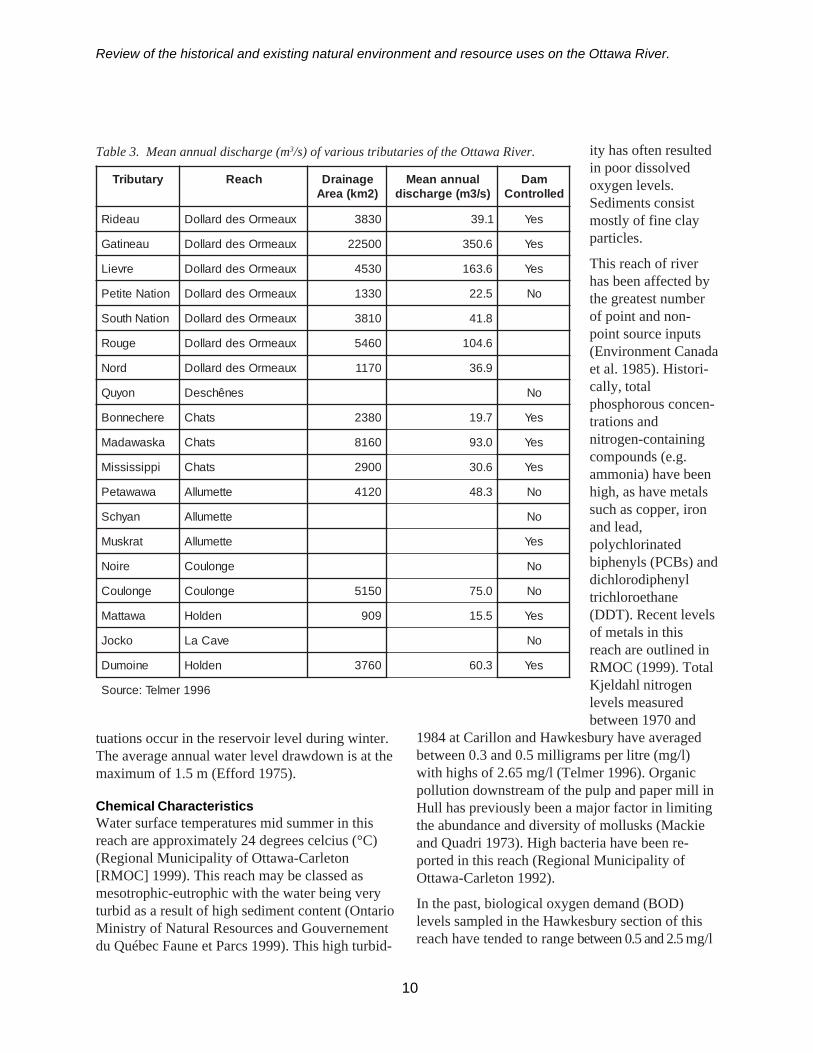
There are at least 47 tributaries in this portion ofthe Ottawa River (26 in Québec and 21 in Ontario)(Ontario Ministry of Natural Resources andGouvernement du Québec Faune et Parcs 1999).The main tributaries of this section include RivièreNord, Rivière Rouge, South Nation River, RivièrePetite Nation, Rivière Lièvre, Rivière Gatineau,and Rideau River. The mean annual discharge ofselected tributaries is described in Table 3.
Present hydrologyCarillon receives the full flow of the Ottawa Riverbasin (drainage area is 143,000 km2) and has a
mean annual discharge of 1,933 m3/s (Telmer1996). The maximum discharge recorded atCarillon was 8,190 m3/s in 1976 and the lowestwas 306 m3/s in 1971 (Hydro Québec 1996).
Water levels in this reach of the river are regulatedby the Carillon Dam. Carillon (generating station)GS is operated as a run-of-river (very little waterstorage) plant during the summer months and as apeaking system (water is passed and hydro pro-duced only during periods of high demand)between October and April (Hydro Québec 1996).Water level changes are relatively stable during thesummer months since the operation of the CarillonDam restrains the spring flood to only about 50centimetre (cm) for a period of approximately twoto three days each spring (Figure 10). Daily fluc-
Review of the historical and existing natural environment and resource uses on the Ottawa River.
tuations occur in the reservoir level during winter.The average annual water level drawdown is at themaximum of 1.5 m (Efford 1975).
Chemical CharacteristicsWater surface temperatures mid summer in thisreach are approximately 24 degrees celcius (°C)(Regional Municipality of Ottawa-Carleton[RMOC] 1999). This reach may be classed asmesotrophic-eutrophic with the water being veryturbid as a result of high sediment content (OntarioMinistry of Natural Resources and Gouvernementdu Québec Faune et Parcs 1999). This high turbid-
10
Table 3. Mean annual discharge (m3/s) of various tributaries of the Ottawa River.
yratubirT hcaeR eganiarD)2mk(aerA
launnanaeM)s/3m(egrahcsid
maDdellortnoC
uaediR xuaemrOseddralloD 0383 1.93 seY
uaenitaG xuaemrOseddralloD 00522 6.053 seY
erveiL xuaemrOseddralloD 0354 6.361 seY
noitaNetiteP xuaemrOseddralloD 0331 5.22 oN
noitaNhtuoS xuaemrOseddralloD 0183 8.14
eguoR xuaemrOseddralloD 0645 6.401
droN xuaemrOseddralloD 0711 9.63
noyuQ senêhcseD oN
erehcennoB stahC 0832 7.91 seY
aksawadaM stahC 0618 0.39 seY
ippississiM stahC 0092 6.03 seY
awawateP ettemullA 0214 3.84 oN
nayhcS ettemullA oN
tarksuM ettemullA seY
erioN egnoluoC oN
egnoluoC egnoluoC 0515 0.57 oN
awattaM nedloH 909 5.51 seY
okcoJ evaCaL oN
eniomuD nedloH 0673 3.06 seY
6991remleT:ecruoS
ity has often resultedin poor dissolvedoxygen levels.Sediments consistmostly of fine clayparticles.
This reach of riverhas been affected bythe greatest numberof point and non-point source inputs(Environment Canadaet al. 1985). Histori-cally, totalphosphorous concen-trations andnitrogen-containingcompounds (e.g.ammonia) have beenhigh, as have metalssuch as copper, ironand lead,polychlorinatedbiphenyls (PCBs) anddichlorodiphenyltrichloroethane(DDT). Recent levelsof metals in thisreach are outlined inRMOC (1999). TotalKjeldahl nitrogenlevels measuredbetween 1970 and
1984 at Carillon and Hawkesbury have averagedbetween 0.3 and 0.5 milligrams per litre (mg/l)with highs of 2.65 mg/l (Telmer 1996). Organicpollution downstream of the pulp and paper mill inHull has previously been a major factor in limitingthe abundance and diversity of mollusks (Mackieand Quadri 1973). High bacteria have been re-ported in this reach (Regional Municipality ofOttawa-Carleton 1992).
In the past, biological oxygen demand (BOD)levels sampled in the Hawkesbury section of thisreach have tended to range between 0.5 and 2.5 mg/l

Review of the historical and existing natural environment and resource uses on the Ottawa River.
(Figure 11) and total phosphorus between 0.025and 0.1 mg/l (Figure 12). Recent phosphorus levelsrange between 0.02 and 0.03 mg/l in this reach.The pH is 7.5 (RMOC 1999).
Natural environment
FisheriesThis portion of the OttawaRiver supports a relativelydiverse coolwater/warmwater fish communitycomprised of at least 75different fish species(Appendix 1). Sportspecies include walleye,sauger, northern pike,muskellunge, yellowperch, smallmouth bass,largemouth bass, sturgeon,and black crappie (Table4). The Ottawa River hasalways provided manyspecies of fish. Referenceis made to the small villageof Chute à Blondeau, 11km east of Hawkesbury,which possessed a govern-ment wharf and was a portof call for the freighters ontheir voyage from Mon-treal to Ottawa.
“Among other things whichcontributed to render thisplace one of considerablecelebrity, was its excellentfishing grounds, manyvarieties of fish—shadespecially —being caughtin large numbers. Duringthe decade following 1845,as many as 1200 fish weresometimes caught in oneday, and though they
rapidly decreased from that time, 400 wereoften caught in a day during the two orthree years which preceded the building ofthe dams” (Department of Lands andForests, 1964).
Figure 10. Mean monthly water levels in Lac Dollard des Ormeaux since 1964.
11
Figure 11. Total phosphorous levels at Hawkesbury (1970-2000).
40.8
41.0
41.2
41.4
41.6
41.8
42.0
42.2
42.4
Jan Feb Mar Apr May Jun Jul Aug Sep Oct Nov DecMonth
Wat
er le
vel (
m)
0.00
0.05
0.10
0.15
0.20
0.25
0.30
0.35
0.40
1970
-01-
13
1970
-08-
2019
71-0
7-19
1972
-06-
27
1973
-03-
1419
74-0
3-27
1974
-12-
1719
75-0
9-22
1976
-10-
2519
77-0
6-14
1979
-02-
1919
80-0
9-19
1984
-08-
1519
85-1
0-16
1986
-09-
11
1988
-09-
2319
90-1
1-26
1992
-04-
2119
92-1
1-23
1993
-12-
1619
95-0
7-24
1996
-07-
1719
97-0
6-18
1998
-04-
2119
98-1
1-23
2000
-04-
18

Review of the historical and existing natural environment and resource uses on the Ottawa River.
After the construction of the first dam at Carillon,fishing continued to excel, especially below thedam where the fish came to spawn and could notpass the barrier. American shad, lake sturgeon, andwalleye are known to spawn downstream of theCarillon Dam. The annual run of shad providedlocal residents with a year’s supply of fish. Fishmerchants from Montreal would take the shad bymeans of large landing nets, dress and salt theminto barrels for the Montreal market. Walleye werealso taken in quantity. Sturgeon were often takenthere but the best sturgeon waters extended fromthe Carillon Dam to Temiscaming.
There is diverse habitat throughout this reachnecessary for spawning, nursery and rearing.Muskellunge are known to spawn in variouswetland areas of the northern shore of the OttawaRiver. Many of the tributaries on the Québec sidehave recently been documented as important formuskellunge spawning, but many of these areaffected by urbanization, agriculture, and industry.Pike have also been documented spawning inwetland areas throughout the reach. Walleye areknown to spawn below dams in tributaries andbelow the control structures at Chaudière Falls.
Lake sturgeon spawnimmediately downstreamof Chaudière Falls, belowVictoria Island. At onetime, they spawned at therapids near Hawkesburybut have abandoned thisarea after water levelsincreased from the con-struction of the CarillonDam (Easton 1968).Numerous species such aslargemouth bass, rock bass,carp, smelt, bluegill, blackcrappie, emerald shiner,brown bullhead, andpumpkinseed spawn inareas like Kettle IslandBay and Upper DuckIsland Bay.
Generally the distribution and abundance of fishvaries considerably among locations, with the mostdiverse fish communities found in the shallow,littoral areas. Based on gill netting catches, saugerare more abundant than walleye which is believedto be attributable to the high turbidity of this reach.Both largemouth and smallmouth bass populationsappear stable and are most abundant in bays alongthe river. Little is known about the status of north-ern pike and muskellunge populations. There isreason to suspect that these stocks may be limitedby the shortage of good spawning habitat, althoughreports from the Ottawa Valley chapter of MuskiesCanada indicate that sizeable populations ofmuskellunge exist, with specimens up to 135 cmbeing caught. There is an active charter fishingindustry, primarily for muskie, on this reach(Critchlow per comm3).
Brown trout have been stocked around the Ottawa-Hull area by local anglers’ groups, but littleincreased fishing success has been noted.
In 2000, there were four commercial fisherieslicensed from Ontario and three from Quebec in
12
Figure 12. Biological Oxygen Demand at Hawkesbury (1970 - 2000).
3 David Critchlow, Conservation Officer, Kemptville District.
0.0
5.0
10.0
15.0
20.0
25.0
1970
-01-13
1970
-08-20
1971
-07-19
1972
-06-27
1973
-03-14
1974
-03-27
1974
-12-17
1975
-09-22
1976
-10-25
1977
-06-14
1979
-04-24
1980
-10-29
1986
-08-25
1989
-06-21
1991
-07-26
1992
-06-11
1993
-06-24
1994
-05-31
1995
-10-03
1996
-09-23
1997
-09-23
1998
-07-22
1999
-07-12

Review
of the historical and existing natural environment and resource uses on the O
ttawa R
iver.
Table 4. Fish species by reach of the Ottawa River.
13
seicepShsiF seddralloDcaLxuaemrO senehcseDcaL stahCsedcaL udneFrehcoRudcaL dnaekaLettemullA
egnoluoCcaL ekaLnedloH evaCalcaL
hsiftaclennahC X X X X X X
daehllubnworB X X X X X X
esrohderdaehtrohS X X X X X X
esrohderreviR X X X X X
eyellaW X X X X X X X
reguaS X X X X X X X
ssabhtuomegraL X X X X X
ssabhtuomllamS X X X X X X X
ssabkcoR X X X X X X X
hcrepwolleY X X X X X X X
ekipnrehtroN X X X X X X X
egnulleksuM X X X X X
rekcusetihwnommoC X X X X X X X
deesnikpmuP X X X X X
noegrutsekaL X X X X X X
ragesongnoL X X X X X X
eipparckcalB X X X X
hsifllaF X X X X X X
hsifetihwekaL X X X X
tuortekaL X X X
gnirrehekaL X X X X
tobruB X X X X X
eyenooM X X X X X X X
leenaciremA X X X
wonnimesontnulB X
renihsdlaremE X X X X X X X
praC X X
Review of the historical and existing natural environment and resource uses on the Ottawa River.
this reach of river. Species licensed for harvestinclude bullhead, sunfish, yellow perch, suckers,carp, channel catfish, white perch, freshwaterdrum, black crappie, rock bass, and American eel.The harvest of eel by Ontario commercial harvest-ers was estimated at 295 kilograms (kg) in 1999(Critchlow 2000) and 69 kg in 2000 (OMNRunpublished data). Eels are still being sampled innetting projects (Appendix 1). The commercialfishery for lake sturgeon was suspended in thisreach of river in 1990 due to a decline in abun-dance and high contaminant levels. Recent nettingstudies have sampled an increased number ofjuvenile sturgeon in their nets.
A season-long creel survey has never been com-pleted on this section of the river, although severalseasonal angler surveys have been conducted onportions of this reach. It is estimated that from25–30,000 angler days of effort are expended onthe Québec portion of the river each year. Approxi-mately one third of the annual fishing pressureoccurs during the winter. On the Ontario portion ithas been estimated that there are some 20,000angler-days of effort per year. The winter effortmirrors that of Québec, with 350 ice huts beingregistered in 1992.
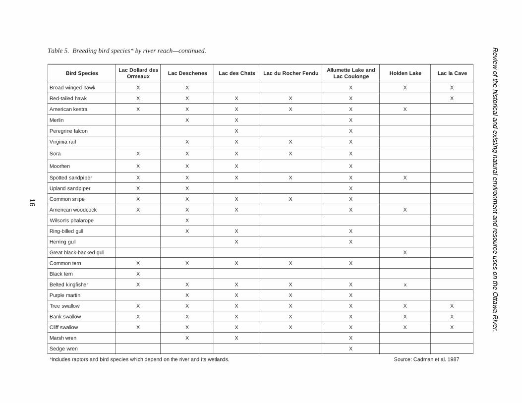
WildlifeAt least 27 water birds4 (including the black tern)and seven raptors have been previously reported tobreed in this reach of the river (Table 5) (Cadmanet al. 1987).
Some of the best migratory bird habitat on theOttawa River is located in this section of riverbetween Montebello and Gatineau (Gaffield 1997;SFEP 2001). Species include the black duck (mostabundant), northern pintail, northern shoveler,green-winged teal, blue-winged teal, wood duck,and American wigeon. Brewery Creek locatedacross from the Gatineau River was once knownfor its variety of unique birds. As well, KettleIsland has been known for its blue herons, king-
fishers, and diversity of ducks, which use thesubmergent vegetation, found along the north sideof the island. Likewise, Lower Duck Island andmarshes on the north side of the river attractnumerous waterfowl (McKeating 1990). DucksUnlimited is involved in management of wetlandsin Baie de Lochaber, Baie Clement and LacMcLaurin (SFEP 2001).
Large spring migrations of Canada geese, as wellas diving ducks (e.g. merganser, goldeneye, andscaup), dabblers (e.g. black duck, mallard, northernpintail, northern shoveller, wood duck, and teal)and even some snow geese, use the ReserveFaunique de Plaisance (Club des Ornithologues del’Outaouais 2000). Rails, herons, least bitterns anddabblers have been reported in nearby ThursoMarsh (Sankey 1987). Other concentrations ofCanada geese in this reach include Baie desArcands, Baie de la Penetecote, Baie Noire, BaieLochaber (SFEP 2001), and Voyageur ProvincialPark (Critchlow pers comm.)
Of interest is a waterfowl habitat study conductedby Munro (1967) prior to and up to four years afterimpoundment behind Carillon GS. It was notedthat by 1965 the aquatic vegetation appeared tohave stabilized in broad zones as follows: grassesand sedges up to 0.3 m depth, Canadian waterweedand scarlet and amphibious knotweeds in depthsbetween 0.3 and 1.3 m and scarlet knotweed indepths of 1.3–1.6 m. Munro noted that the abun-dance of breeding waterfowl in this reachincreased following impoundment in direct relationto the degree of interspersion of emergent vegeta-tion and small bodies of open water near loafingspots. Duck hunting is popular in this reach of river(Critchlow per comm.)
Numerous muskrat colonies can be found in thisreach between Plaisance and Gatineau, e.g. Baie dela Penetecote, Baie Parisien, Baie Noire, BaieDaragon, Baie Lochaber, Baie Clement, LacMcLaurin and Kettle Island (SFEP 2001).
14
4 Water birds comprises all species dependent on water i.e. grebes, herons, geese, ducks, rails, sandpipers andgulls.

Review
of the historical and existing natural environment and resource uses on the O
ttawa R
iver.
Table 5. Breeding bird species* by river reach.
15
seicepSdriB seddralloDcaLxuaemrO senehcseDcaL stahCsedcaL udneFrehcoRudcaL dnaekaLettemullA
egnoluoCcaL ekaLnedloH evaCalcaL
noolnommoC X X X
ebergdellib-deiP X X X X X
tnaromrocdetserc-elbuoD X
nrettibnaciremA X X X
nrettibtsaeL X
noreheulbtaerG X X X X
norehdekcab-neerG X X X X
esoogadanaC X X X X X
kcuddooW X X X X X
laetdegniw-neerG X X X
kcudkcalbnaciremA X X X X X
drallaM X X X X X X
liatnipnrehtroN X X X
laetdegniw-eulB X X X X X X
relevohsnrehtroN X X X
llawdaG X X
noegiwnaciremA X X X
kcuddekcen-gniR X X
puacsresseL X
resnagremdedooH X X X X
resnagremnommoC X X X X X
resnagremdetsaerb-deR X
yerpsO X X X X X X
elgaedlaB X X X
reirrahnrehtroN X X X X
kwahdennihs-prahS X X X X
kwahs'repooC X X X
.sdnaltewstidnarevirehtnodnepedhcihwseicepsdribdnasrotparfognideerbelbaborprodemrifnocsedulcnI*
Review
of the historical and existing natural environment and resource uses on the O
ttawa R
iver.
seicepSdriB seddralloDcaLxuaemrO senehcseDcaL stahCsedcaL udneFrehcoRudcaL dnaekaLettemullA
egnoluoCcaL ekaLnedloH evaCalcaL
kwahdegniw-daorB X X X X X
kwahdeliat-deR X X X X X X
lartseknaciremA X X X X X X
nilreM X X X
noclafenirgereP X X
liarainigriV X X X X
aroS X X X X X
nehrooM X X X X
repipdnasdettopS X X X X X X
repipdnasdnalpU X X X
epinsnommoC X X X X X
kcocdoownaciremA X X X X X
eporalahps'nosliW X
llugdellib-gniR X X X
lluggnirreH X X
llugdekcab-kcalbtaerG X
nretnommoC X X X X X
nretkcalB X
rehsifgnikdetleB X X X X X x
nitramelpruP X X X X
wollawseerT X X X X X X X
wollawsknaB X X X X X X X
wollawsffilC X X X X X X X
nerwhsraM X X X
nerwegdeS X
tenamdaC:ecruoS.sdnaltewstidnarevirehtnodnepedhcihwseicepsdribdnasrotparsedulcnI* 7891.la
Table 5. Breeding bird species* by river reach—continued.
16
Review of the historical and existing natural environment and resource uses on the Ottawa River.
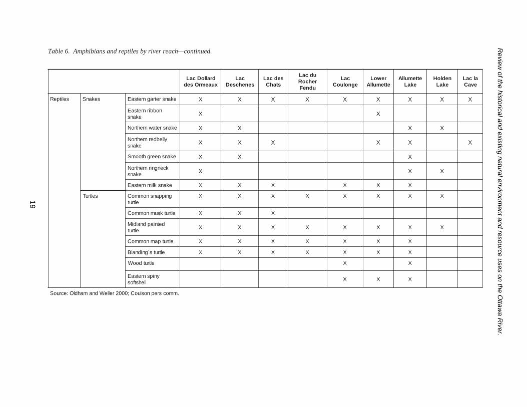
Twenty-seven amphibians and reptiles have beenreported in this reach (Table 6) (Oldham andWeller 2000) in addition to an introduced species,the red-eared slider (Critchlow per comm).
Unique speciesTwo threatened, two vulnerable and one endan-gered species have been reported in this reach(Table 7) (OMNR 2001a).
Wetlands, parks, and environmentally sensitiveareasThere are sixteen provincially and locally signifi-cant marshes found between Carillon GS andGatineau, e.g. at Hawkesbury, Hamilton Island,Cunninghan Bay, Rockland and Duck Island(Table 8). The predominant vegetation in thesemarshes is cattail (Typha sp.). Due to the limitedspring water level increases and abundance ofcattail, many of these marshes are of only limitedvalue for fish spawning habitat. A number of thesemarshes have been developed to increase water-fowl production.
Six Areas of Natural and Scientific Interest (ANSI)are located in this reach of the river (Table 9)(OMNR 2001a). They include four life scienceANSIs at the Baie Lafontaine Islands, PetrieIsland, Green Creek Conservation Area and DuckIslands; and two earth science ANSIs at VoyageurProvincial Park and Rockland. A parc de conserva-tion, which is similar in importance to a nationalpark, is located in Plaisance (SFEP 2001).
Shoreline developmentThe cities of Ottawa and Hull are located in theupstream portion of this reach. There are varioustowns, including Cumberland, Rockland, Gatineau,Hawkesbury and Grenville, along the shore of theriver. Ottawa has a long history of settlement withan ancient aboriginal settlement located in Parc duLac Leamy on the Gatineau River. Since 1961some communities have experienced a decline inpopulation, e.g. Carillon, while others have in-creased in size, e.g. Hawkesbury and Rockland(Ontario Water Resource Commission and Quebec
Water Board 1972; Statistics Canada 2001) (Table10).
Four pulp and paper mills, including J. MacLarenin Thurso and Masson, Canadian InternationalPaper in Gatineau and E.B. Eddy Paper in Hull,currently operate along the north shoreline in thissection of river. Eddy discontinued its pulpingoperations in 1972 (Environment Canada et al.1985). Canadian International Paper closed downits mill in Hawkesbury in 1982 (EnvironmentCanada et al. 1985). Log drives ceased in thissection in 1990. This reach of the river, e.g.Hawkesbury, has been historically used for pulpand paper mills, lumber mills, waterworks andelectrical generation (Denis and White 1911).
In comparison to the whole Ottawa River water-shed, agricultural land use in the watershed of thisreach is quite high, e.g. 77% of the South NationRiver sub-basin, as are built-up areas, e.g. 2.4% ofthe Rideau River sub-basin (Table 11) (Telmer1996).
Lac Deschênes (Chaudière Falls to Chats Fall/Fitzroy)
Pre-development descriptionHistorically, Chaudière Falls was a place of cer-emony, where natives threw tobacco into the fallsin belief that they would be protected from theirenemies (Kennedy 1970). This was an area wherethe river tumbled over a limestone ledge (Figure 13)in a series of channels between islands (Hughsonand Bond 1964). The falls consisted of sevenrapids that poured into the deep kettle with suchtremendous force that it gave the appearance ofboiling water (Figure 14) (Mika and Mika 1982).Early accounts of the falls include:
“the scenery of Chaudière Falls before itwas defaced was truly picturesque, almostindescribably grand. The rocky cliffs,green with the cedars and the pines to therivers brink, its volume of water tossedbroke, dashed into foam, that foam floatingdown like islands of pearl on the bosom ofthe dashing current, the whole surveyed
17

Review
of the historical and existing natural environment and resource uses on the O
ttawa R
iver.
dralloDcaLxuaemrOsed
caLsenehcseD
sedcaLstahC
udcaLrehcoR
udneF
caLegnoluoC
rewoLettemullA
ettemullAekaL
nedloHekaL
alcaLevaC
snaibihpmA sgorF daotnaciremA X X X X X X X X X
repeepgnirpS X X X X X X X X
gorfsurohcnretseW X X X X X X
gorfeertyarG X X X X X X X X
gorfdooW X X X X X X X X
gorfdrapoelnrehtroN X X X X X X X X
gorfeyellaW X X
gorfneerG X X X X X X X X
gorfkniM X X X X
gorflluB X X X X X X X
srednamalaS yppupdumnommoC X X X X
twendettopsdeR X X X
nosreffeJxelpmocrednamalas X X X X X X X X X
rednamalasdettopS X X X
denil-owtnrehtroNrednamalas X X X X
deot-ruoFrednamalas X
kcabdernrehtroNrednamalas X X X X
Table 6. Amphibians and reptiles by river reach.
18
Review
of the historical and existing natural environment and resource uses on the O
ttawa R
iver.
dralloDcaLxuaemrOsed
caLsenehcseD
sedcaLstahC
udcaLrehcoR
udneF
caLegnoluoC
rewoLettemullA
ettemullAekaL
nedloHekaL
alcaLevaC
selitpeR sekanS ekansretragnretsaE X X X X X X X X X
nobbirnretsaEekans X X
ekansretawnrehtroN X X X X
yllebdernrehtroNekans X X X X X X
ekansneerghtoomS X X X
kcengnirnrehtroNekans X X X
ekansklimnretsaE X X X X X X
seltruT gnippansnommoCeltrut
X X X X X X X X
eltrutksumnommoC X X X
detniapdnaldiMeltrut X X X X X X X X
eltrutpamnommoC X X X X X X X
eltruts`gnidnalB X X X X X X X
eltrutdooW X X
ynipsnretsaEllehstfos X X X
.mmocsrepnosluoC;0002relleWdnamahdlO:ecruoS
Table 6. Amphibians and reptiles by river reach—continued.
19
Review of the historical and existing natural environment and resource uses on the Ottawa River.
Table 7. Unique plant and wildlife species by river reach.
from the brow of the hills on the east in theevening sun, to be comprehended, to beesteemed, to be capturously admired, mustbe dwelt upon. Thus Samuel Champlainsaw it, Mirrick and Stevens saw it, thusPhilemon Wright saw it before a tree wasremoved or an arched has spanned itexcept the rainbow in its natural grandeur,in its virgin beauty, in its pristine sublim-ity. This is much the finest falls on theriver” (Gourlay 1896).
As described by Champlain:
“the water falls…impetuosity on a rockthat with the passage of time it has hol-lowed out a wide, deep basin. This water
falls makes such a noise in the basin thatone can hear it from more than twoleagues away” (Kennedy 1970).
Figures 13 and 15 illustrate the rock ledges thatwere present at Chaudière Falls. Figure 14 gives anindication of how the falls appeared during highwater flows before the dams were constructed.Alterations at Chaudière Falls occurred early insettlement. The first industries, a grist mill and asaw mill driven by waterwheels, were establishedin 1802 at the Chaudière Falls (Hughson and Bond1964). The first log slide was built at this locationin 1829, and a second one built on the south side in1836 (Hincks 1978). A diversion dam, approxi-mately 45.7 m long and 4.6 m high, was
20
hcaeR seicepS
xuaemrOseddralloDcaL )*T(wonnimspiltuC )E(noclafenirgereP
)T(eltrutllehstfosynipsnretsaE )V(esrohderreviR
)V(yerpmalkoorbnrehtroN
senêhcseDcaL trowlliuqs'nuarB eyenedlogs'worraB
traehgnitaolF )V(nrettibtsaeL
silixelfsajaN )V(kwahderedluohs-deR
sutailofrepnotegomatoP )V(esrohderreviR
sullisupnotegomatoP enotsnrutydduR
iisnibbornotegomatoP esoogwonS
sulliripsnotegomatoP rednamalass'yalbmerT
toofworcretaW
ssargratsretaW
stahCsedcaL worrapsreppohssarG )V(esrohderreviR
)V(kwahderedluohs-deR
udneFrehcoRudcaL reppilsydaldaehsmaR
egnoluoCcaLdnaekaLettemullA hsurdlaB elgaedlaBtaehwkcubsalguoD )T(eltrutllehstfosynipsnretsaE
rehtaehdnaS )E(noclafenirgerePhsur-bulcs'htimS eltrutdooW
hsurlubs'yerroT
dnatcAseicepSderegnadnEoiratnOrepsa)E(deregnadnero;)T(denetaerht;)V(elbarenluvsiseicepS*1002CIWESOC
a1002RNMO;2991rueociloJ;9791.dtLnrefdeR&rotcorP/dtLnocorivnE:ecruoS

Review of the historical and existing natural environment and resource uses on the Ottawa River.
constructed halfway down the channel. A flume201 m long, 1.8 m deep and 30.2 m wide taperingto 6.1 m wide was built from this structure downthe north side of Victoria Island to service water-
lots. A similar flumewas built onChaudière Island(Hughson and Bond1964). In 1868, adiversion dam 106.7m long and 22.9 mwide at the base wasconstructed acrossChaudière Falls toallow for continuoussupply of water tothe mills. Thisstructure was built ofstrong crib-workfilled with stone,faced with heavyplanks, and bracedwith iron. Thisstructure was laterreplaced by a largerstructure in 1896(Hughson and Bond1964). In the 1890’s,two small powerplants were built atChaudière Falls tosupply industrial andresidential power toOttawa (Hincks1978). The RingDam was constructedin 1909 (Tremblay etal. 1970).
Despite the dam atChaudière Falls, LacDeschênes is still thesame beautifulstretch of water thatwas observed byearly travelers(Legget 1975); the
shoreline remains relatively unaltered due to theconstruction of hydraulic structures (Ottawa RiverEngineering Board 1965).
noitceSreviR dnalteW ecnacifingiS
xuaemrOseddralloDcaL dnalteWdnalsIkcuD tnacifingisyllaicnivorP
dnalteWdnalsIeirteP tnacifingisyllaicnivorP
dnalteWeniatnofaLeiaB tnacifingisyllaicnivorP
pmawSteertSdooW tnacifingisyllacoL
hsraMreviReniatnofaL tnacifingisyllacoL
hsraMdnalkcoR tnacifingisyllaicnivorP
hsraMdnalsIecneralC tnacifingisyllaicnivorP
hsraMdnalsIrekraP tnacifingisyllaicnivorP
dnalteWyaBmahgninnuC tnacifingisyllacoL
dnalteWyaBreinehC tnacifingisyllacoL
hsraMtnioPnawoGcM tnacifingisyllacoL
yaBacitazA tnacifingisyllacoL
hsraMdnalsInotlimaH tnacifingisyllacoL
hsraMyrubsekwaH tnacifingisyllacoL
hsraMxuaemrOseddralloD tnacifingisyllacoL
hsraMnolliraC tnacifingisyllaicnivorP
senêhcseDcaL dnalteWkeerCecnatsnoC tnacifingisyllaicnivorP
dnalteWyaBs'yelrihS tnacifingisyllaicnivorP
dnalteWekaLduM tnacifingisyllaicnivorP
stahCsedcaL dnalteWhtuomreviRerehcennoB tnacifingisyllaicnivorP
dnalteWgnimopoN tnacifingisyllaicnivorP
dnalteWdnalsIsirroM tnacifingisyllaicnivorP
dnalteWeynSippississiM tnacifingisyllaicnivorP
egnoluoCcaLdnaekaLettemullA dnalteWkeerCselaH )?(tnacifingisyllaicnivorP
xelpmoCyaBksiL/yaByelzaH tnacifingisyllaicnivorP
dnalteWyaBs'wolleB tnacifingisyllaicnivorP
dnalteWyaBs'yssenneH )?(tnacifingisyllaicnivorP
dnalteWyaByollaM )?(tnacifingisyllaicnivorP
dnalteWyaBxiorcaL )?(tnacifingisyllaicinivorP
a1002RNMOecruoS
Table 8. Wetlands by river reach.
21

Review of the historical and existing natural environment and resource uses on the Ottawa River.
Existing physical descriptionLac Deschênes, the reach of river betweenChaudière Falls and Chats Falls, is 52.8 km long
22
and has a surfacearea of 10,900 ha.The cities of Ottawaand Hull are the mostprominent features onthis reach. There areseveral natural sets ofrapids remaining inthis reach close toOttawa and Hullincluding DeschênesRapids, RemicRapids and LittleChaudière Rapids.The Québec shorelineis characterized bydepths of less than2 m and extensivesections of wetlands.Water depths aregenerally less than9.0 m; however, thereis a deep troughbetween Twelve MileIsland and AylmerIsland that reachesdepths of 49 m.
The Chaudière Dam(Figures 16 and 17)maintains a constantwater level for powergeneration at Hull 2,E.B. Eddy (intakeslocated on the northend of the dam) andfour hydro plants atthe southern end ofthe dam. Additionalcharacteristics of theHull 2 GS are out-lined in Table 2. Thedam has 50 gates tocontrol water levels
(Abdelnour et al. 2000). However, the dam con-trols very little water and has no storage capacity(Ottawa River Regulation Planning Board 1987).
Table 9. Environmentally sensitive areas by river reach.
noitceSreviR aerAevitisneSyllatnemnorivnE
xuaemrOseddralloDcaL ecnasialPednoitavresnoCedcraP
ISNAecneicShtraEkraPlaicnivorPruegayoV
ISNAecneicShtraEnaibmacerPdnalkcoR
ISNAecneicSefiLetadidnaCsdnalsIeniatnofaLeiaB
ISNAecneicSefiLetadidnaCdnalteWdnalsIeirteP
ISNAecneicSefiLaerAnoitavresnoCkeerCneerG
ISNAecneicSefiLetadidnaCsdnalsIkcuD
senêhcseDcaL ISNAecneicSefiLetadidnaCaerAnoitavresnoCainnatirB
ISNAecneicShtraEetadidnaCdnalteWhcaeBawattO
ISNAecneicShtraEdnalteWyaBs'yelrihS
ISNAecneicSefiLdnalteWkeerCecnatsnoC
ISNAecneicSefiLetadidnaCserohSyaBeohsesroH
ISNAecneicShtraEsllihdnaSyaBecnatsnoC
kraPlaicnivorPyorztiF
stahCsedcaL ISNAecneicSefiLdnalteWeynSippississiM
ISNAecneicSefiLaerAnoitavresnoCdnalsIsirroM
lotsirBedeuqinuaFegufeRudtejorP
udneFrehcoRudcaL kraPyawretaWlaicnivorP
egnoluoCcaLdnaekaLettemullA ISNAecneicShtraEselohepiPessaPaL
ISNAecneicSefiLecarreTawawateP
*FPRneidnI'leduaessiuR
FPRelttiLsemaJ
FPRehcnalBetêTàelgiA'leD
ekaLnedloH FPRuaetniLérdnA
kraPlaicnivorPyaBdoowtfirD
evaCalcaL ISNAecneicSefiLtseroFekaLrednaxelA
ISNAecneicShtraEreviRawattO/okcoJ
ISNAecneicSefiLsworraNnotloC
ISNAecneicSefiLtnioPeerteniP
ehtnevigsieuqigoloceevreserA.euqigoloceevreseredtcejorpdetangisedcebeuQasiFPR*cebeuQninoitcetorpfoleveltsehgih
1002PEFS;a1002RNMOecruoS

Review of the historical and existing natural environment and resource uses on the Ottawa River.
This portion of the riverhas a total of 21 relativelysmall tributaries (11 inQuébec and 10 in Ontario)(Ontario Ministry ofNatural Resources andGouvernement du QuébecFaune et Parcs 1999). Thelargest tributaries are theMississippi Snye (whichcurrently has a very smalldischarge) and ConstanceCreek in Ontario and theQuyon River in Québec.The mean annual dis-charge of selectedtributaries is described inTable 3.
23
hcaeR ytiC/nwoT 1691 6991 egnahC%
xuaemrOseddralloDcaL nolliraC 724 852 04-
yrubsekwaH 1668 261,01 71+
dnalkcoR 7303 0708 561+
senêhcseDcaL lluH 929,65 933,26 01+
awattO 593,303 264.245 97+
stahCsedcaL roirpnrA 4745 3117 03+
udneFrehcoRudcaL yaBsllebpmaC 4201 478 51-
nosyrB 735 357 04+
egnoluoCcaLdnaekaLettemullA egnoluoCtroF 3281 6171 6-
ekorbmeP 197,61 771,41 61-
awawateP 9054 0456 54+
reviRpeeD 7735 1944 53-
ekaLnedloH awattaM 4133 1822 13-
.seiradnuobytinummocnisegnahcoteudffotahwemosebyamsraeyneewtebnosirapmoC*
6991remleT:ecruoS
Table 10. 1961 and 1996 populations* by river reach.
Table 11. Mean percentage of land use class per tributary sub-basin of the Ottawa River.
hcaeR yratubirT -busfoaerA)2mk(nisab
%tseroF
%erutlucirgA
pu-tliuB%aera
%retawnepO
xuaemrOseddralloDcaL uaediR 2324 6.43 3.95 4.2 7.3
uaenitaG 18542 2.29 1.2 2.0 6.5
erveiL 05601 2.49 6.3 1.0 1.2
noitanetiteP 7172 5.19 8.5 0.0 8.2
noitaNhtuoS 7965 7.22 0.77 0.0 3.0
eguoR 7797 6.59 6.3 3.0 2.0stahCsedseL erehcennoB 2664 1.97 8.81 0.0 1.2
aksawadaM 4909 5.69 9.0 0.0 6.2
ippississiM 2364 0.17 1.72 1.0 8.1egnoluoCcaL/ekaLettemullA awawateP 2044 3.79 2.0 0.0 5.2
erioN 4472 4.69 5.1 0.0 1.2
egnoluoC 6045 5.89 6.0 0.0 9.0ekaLnedloH awattaM 7285 6.79 0.0 6.0 8.1
eniomuD 3844 3.69 0.0 0.0 7.36991remleT:ecruoS
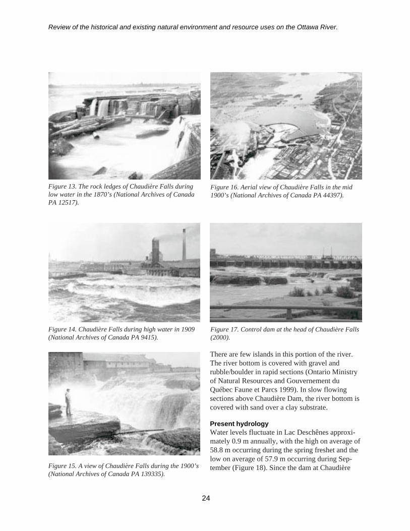
Review of the historical and existing natural environment and resource uses on the Ottawa River.
There are few islands in this portion of the river.The river bottom is covered with gravel andrubble/boulder in rapid sections (Ontario Ministryof Natural Resources and Gouvernement duQuébec Faune et Parcs 1999). In slow flowingsections above Chaudière Dam, the river bottom iscovered with sand over a clay substrate.
Present hydrologyWater levels fluctuate in Lac Deschênes approxi-mately 0.9 m annually, with the high on average of58.8 m occurring during the spring freshet and thelow on average of 57.9 m occurring during Sep-tember (Figure 18). Since the dam at Chaudière
Figure 13. The rock ledges of Chaudière Falls duringlow water in the 1870’s (National Archives of CanadaPA 12517).
Figure 14. Chaudière Falls during high water in 1909(National Archives of Canada PA 9415).
Figure 15. A view of Chaudière Falls during the 1900’s(National Archives of Canada PA 139335).
Figure 16. Aerial view of Chaudière Falls in the mid1900’s (National Archives of Canada PA 44397).
Figure 17. Control dam at the head of Chaudière Falls(2000).
24
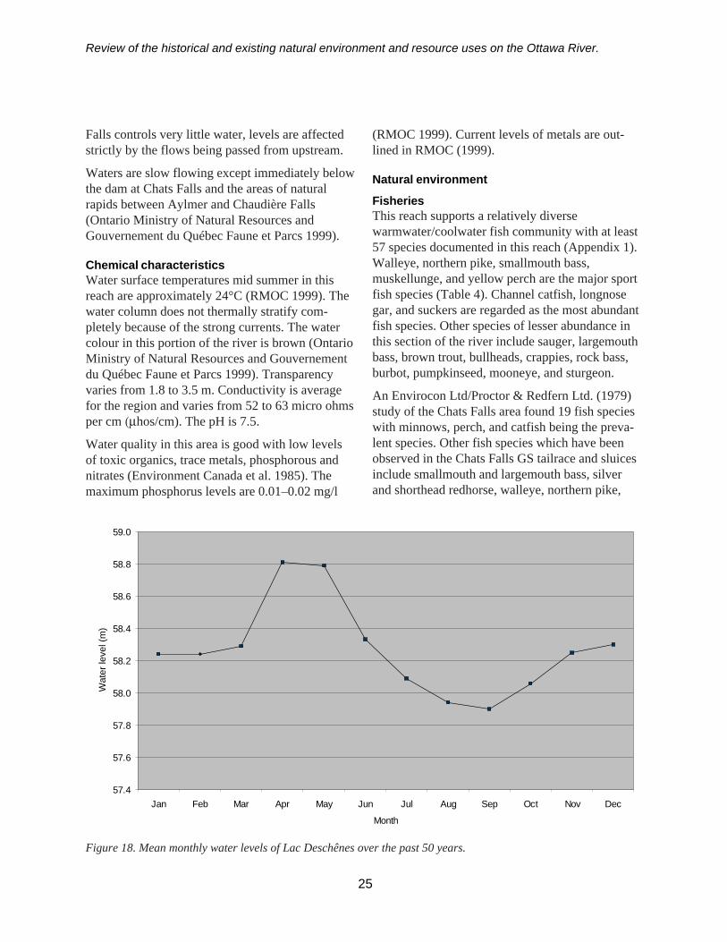
Review of the historical and existing natural environment and resource uses on the Ottawa River.
Falls controls very little water, levels are affectedstrictly by the flows being passed from upstream.
Waters are slow flowing except immediately belowthe dam at Chats Falls and the areas of naturalrapids between Aylmer and Chaudière Falls(Ontario Ministry of Natural Resources andGouvernement du Québec Faune et Parcs 1999).
Chemical characteristicsWater surface temperatures mid summer in thisreach are approximately 24°C (RMOC 1999). Thewater column does not thermally stratify com-pletely because of the strong currents. The watercolour in this portion of the river is brown (OntarioMinistry of Natural Resources and Gouvernementdu Québec Faune et Parcs 1999). Transparencyvaries from 1.8 to 3.5 m. Conductivity is averagefor the region and varies from 52 to 63 micro ohmsper cm (µhos/cm). The pH is 7.5.
Water quality in this area is good with low levelsof toxic organics, trace metals, phosphorous andnitrates (Environment Canada et al. 1985). Themaximum phosphorus levels are 0.01–0.02 mg/l
25
(RMOC 1999). Current levels of metals are out-lined in RMOC (1999).
Natural environment
FisheriesThis reach supports a relatively diversewarmwater/coolwater fish community with at least57 species documented in this reach (Appendix 1).Walleye, northern pike, smallmouth bass,muskellunge, and yellow perch are the major sportfish species (Table 4). Channel catfish, longnosegar, and suckers are regarded as the most abundantfish species. Other species of lesser abundance inthis section of the river include sauger, largemouthbass, brown trout, bullheads, crappies, rock bass,burbot, pumpkinseed, mooneye, and sturgeon.
An Envirocon Ltd/Proctor & Redfern Ltd. (1979)study of the Chats Falls area found 19 fish specieswith minnows, perch, and catfish being the preva-lent species. Other fish species which have beenobserved in the Chats Falls GS tailrace and sluicesinclude smallmouth and largemouth bass, silverand shorthead redhorse, walleye, northern pike,
Figure 18. Mean monthly water levels of Lac Deschênes over the past 50 years.
57.4
57.6
57.8
58.0
58.2
58.4
58.6
58.8
59.0
Jan Feb Mar Apr May Jun Jul Aug Sep Oct Nov Dec
Month
Wat
er le
vel (
m)

Review of the historical and existing natural environment and resource uses on the Ottawa River.
and muskellunge (Niblett Environmental Associ-ates Inc. 1990). Ontario Hydro staff reported eelsat Chats Falls GS (Chubbuck 1993), however, thenumbers of eels observed annually have beendeclining. Eels were last sampled in netting effortsin 1989 (Appendix 1).
Lake sturgeon spawn downstream of the generat-ing station. A study in 1949 sampled over 400spawning lake sturgeon. Numbers of sturgeon inthis reach of river have declined. A survey of thesame spawning area in 2001 yielded only eightsturgeon. Recruitment is considered to be a limit-ing factor in this reach of the river (Haxton inreview).
The Deschênes Rapids is an area in which speciessuch as walleye, smallmouth bass, rock bass,mooneye, suckers, channel catfish, sauger, andmottled sculpins are known to spawn. Areas suchas Britannia Bay support spawning northern pike,rock bass, longnose gar, silvery minnow, spottailshiner, brown bullhead, and pumpkinseed.
Traditionally there was one commercial fishermanlicensed by Ontario but this licence has beeninactive since 1988 (Ontario Ministry of NaturalResources and Gouvernement du Québec Faune etParcs 1999). Presently there are three activeOntario baitfish licences issued for baitfish harvestin this section of the river. There is a commercialfishery for lake sturgeon licences out of Québec inthe Quyon area with a quota of 0.1 kilogram perhectare (kg/ha) of Quebéc waters.
A season long creel survey has not been completedfor this section of the river although several sea-sonal angler surveys have been conducted onportions of this reach (Ontario Ministry of NaturalResources and Gouvernement du Québec Faune etParcs 1999). In the Québec portion of this sectionof the river, fishing effort has been estimated atapproximately 15,400 angler days per year. Atleast 40% of this effort is exerted in the section ofthe rapids adjacent to Ottawa-Hull. The only creeldata for the Ontario waters were collected in the
winter of 1989 and for the mid-summers of 1978and 1981. It was estimated that 18,000 angler daysof effort were expended that winter, while summerpressure was estimated at about 2,500 angler days.The main species in the catch included walleye,bass, pike, and channel catfish.
WildlifeAt least 38 water birds (including the ring-neckedduck, lesser scaup and Wilson’s phalarope) andeight raptors have been previously reported5 tobreed in this reach of the river (Table 5) (Cadmanet al. 1987).
Similar to Lac Dollard des Ormeaux, migratingwaterfowl species also concentrate in this reachespecially such areas as Twelve Mile Island, BaieNoire, Mohr Island, Baie Pontiac and FitzroyHarbour (SFEP 2001). For example, over 20,000waterfowl, particularly dabbling ducks have beenknown to visit Baie Noire in the spring (Sankey1987). Canada geese are reported to nest on smallislands in this reach of the river (Club desOrnithologues de l’Outaouais 2000). Shorebirdspecies are limited by the availability of shorelinehabitat.
The best waterfowl habitat in this reach is locatedmore than 20 km downstream at Shirley’s Bay/Britannia Bay. Large numbers of waterfowl, e.g.Canada geese, loons, grebes, scoters, long-tailedduck, snow geese, brant, the rarer greater white-fronted goose, and Richardson’s geese, redhead,canvasback, common goldeneye, and numerousdabbling ducks congregate in Britannia Bay in thespring and in the fall (Bracken and Lewis 2000;Finlay 2000). Thirty-five shorebird species havebeen sighted on the sand flats here (Britannia Bayto Andrew Hayden Park; McKeating 1990) includ-ing the American golden plover, whimbrel, redknot, western sandpiper, purple sandpiper, pipingplover, willet, buff-breasted sandpiper, redphalarope, the rarer spotted redshank, Iceland,lesser black-backed and glacous gulls, the rarermew gull, and the rarer black-legged kittiwake.Other species such as arctic tern, Bonaparte’s gull,
26
5 Confirmed or probable breeding.
Review of the historical and existing natural environment and resource uses on the Ottawa River.
Barrow’s goldeneye, harlequin duck, commonloon, black tern, and thick-billed murre have beensighted in the Deschênes rapids just downstream ofBritannia Bay (Bracken and Lewis 2000; Finlay2000).
Common goldeneye and common mergansers arereported to winter in the open waters around BateIsland and Deschênes Rapids (McKeating 1990).In addition, loons, diving ducks and, often, baldeagles have been reported on the ice in early winteron Lac Deschênes (Sankey 1987). There is apossibility that black-crowned night herons nest onMohr Island.
There are muskrat colonies located in the vicinityof Baie Breckenridge, Baie Noire, Baie Dion andMohr Island (SFEP 2001).
Twenty-six amphibians and reptiles have beenreported in this reach (Table 6) (Oldham andWeller 2000).
Unique speciesThere have been a number of unique or less com-mon species in this reach of the river. AnEnvirocon Ltd/Proctor & Redfern Ltd. (1979)study found five waterfowl and shorebird species(Barrow’s goldeneye, double-creasted cormorant,least bittern, ruddy turnstone, and snow goose),one amphibian species (Tremblay’s salamander)and one reptile species (northern ribbon snake) inthe area downstream of Chats Falls GS (Table 7).Three vulnerable species, i.e. red-shouldered hawk,least bittern, and river redhorse have been reportedin this reach (OMNR 2001a).
Nine uncommon aquatic plant species are locatedin Pontiac Bay just downstream of Chats Falls GS.They include floating heart, Braun’s quillwort,Najas flexilis, Potamogeton perfoliatus,Potamogeton pusillus, Potamogeton robbinsii,Potamogeton spirillus, water crowfoot, and waterstargrass (Table 7).
Wetlands, parks, and environmentally sensitiveareasThere are three provincially significant marshesfound in this reach of the river at Mud Lake,
Shirley’s Bay and Constance Creek (Table 8)(OMNR 2001). Other wetlands are located at BaieBreckenridge, Baie Noire, Mohr Island, WoolseyNarrows, Pointe Hudson, Kedey’s Island andPontiac Bay (SFEP 2001).
There are six ANSIs in this reach: three life scienceANSIs (Britannia Conservation Area, ConstanceCreek and Horseshoe Bay) and three earth ANSIs(Ottawa Beach, Shirley’s Bay and Sandhills)(Table 9) (OMNR 2001a). Parks in this section ofthe river include Britannia Bay Park, Graham BayPark and Fitzroy Provincial Park.
Shoreline developmentThe cities of Ottawa and Hull are the prominentfeatures located at the lower end of this reach.Since 1961 these cities have experienced anincrease, e.g. up to 79%, in population (OntarioWater Resources Commission and Quebec WaterBoard 1972; Statistics Canada 2001) (Table 10).
There are over one thousand households andcottages in this section of the river based on reviewof topographic and Ontario base maps. Aylmer(Québec) and the City of Nepean are municipalitiesthat are found in this section of the river. Industriesin this section include Goldie Mohr Constructionand M.G. MacDonald. Log driving on this sectionof the river has been discontinued since the mid-1970s (Environment Canada et al. 1985).
Lac des Chats (Chats Falls/Fitzroy to CheneauxDam)
Pre-development descriptionThe Chats Falls and Rapids were described as themost beautiful on the river, extending approxi-mately 3.2 km in width. Total rise from the foot ofthe falls to Chats Lake was about 15.2 m (Ells1901). Thirty independent chutes of every conceiv-able form comprised the rapids of Chats Falls(Legget 1975) with fifteen distinct falls averagingabout 7.6 m in height (Sherriff 1831). Figure 19offers an aerial view of this section of river fromMay 1927. Several accounts of the falls prior to theconstruction of the dam include:
27
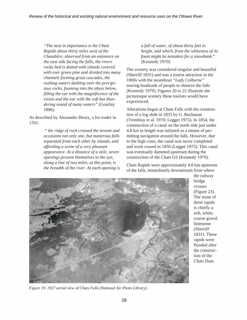
Review of the historical and existing natural environment and resource uses on the Ottawa River.
“The next in importance is the ChatsRapids about thirty miles west of theChaudière, observed from an eminence onthe east side facing the falls, the riversrocky bed is dotted with islands coveredwith ever green pine and divided into manychannels forming great cascades, therushing waters dashing over the precipi-tous rocks, foaming into the abyss below,filling the eye with the magnificence of thevision and the ear with the soft but thun-dering sound of many waters” (Gourlay1896).
As described by Alexander Henry, a fur trader in1761:
“ the ridge of rock crossed the stream andoccasions not only one, but numerous fallsseparated from each other by islands, andaffording a scene of a very pleasantappearance. At a distance of a mile, sevenopenings present themselves to the eye,along a line of two miles, at this point, isthe breadth of the river. At each opening is
a fall of water, of about thirty feet inheight, and which, from the whiteness of itsfoam might be mistaken for a snowbank.”(Kennedy 1970)
The scenery was considered singular and beautiful(Sherriff 1831) and was a tourist attraction in the1800s with the steamboat “Lady Colborne”touring boatloads of people to observe the falls(Kennedy 1970). Figures 20 to 22 illustrate thepicturesque scenery these tourists would haveexperienced.
Alterations began at Chats Falls with the construc-tion of a log slide in 1835 by G. Buchanan(Tremblay et al. 1970; Legget 1975). In 1854, theconstruction of a canal on the north side just under4.8 km in length was initiated as a means of per-mitting navigation around the falls. However, dueto the high costs, the canal was never completedand work ceased in 1856 (Legget 1975). This canalwas eventually dammed upstream during theconstruction of the Chats GS (Kennedy 1970).
Chats Rapids were approximately 4.8 km upstreamof the falls, immediately downstream from where
the railwaybridgecrosses(Figure 23).The stone ofthese rapidsis chiefly asoft, white,coarse gravellimestone(Sherriff1831). Theserapids wereflooded afterthe construc-tion of theChats Dam.
28
Figure 19. 1927 aerial view of Chats Falls (National Air Photo Library).
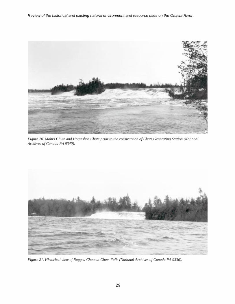
Review of the historical and existing natural environment and resource uses on the Ottawa River.
Figure 20. Mohrs Chute and Horseshoe Chute prior to the construction of Chats Generating Station (NationalArchives of Canada PA 9340).
Figure 21. Historical view of Ragged Chute at Chats Falls (National Archives of Canada PA 9336).
29

Review of the historical and existing natural environment and resource uses on the Ottawa River.
Figure 22. An historical view of the log chute at Chats Falls (National Archives of Canada PA 9330).
Figure 23. Aerial view of Chats Rapids and Chats Falls from upstream, 1920 (National Archives of CanadaC22209).
30
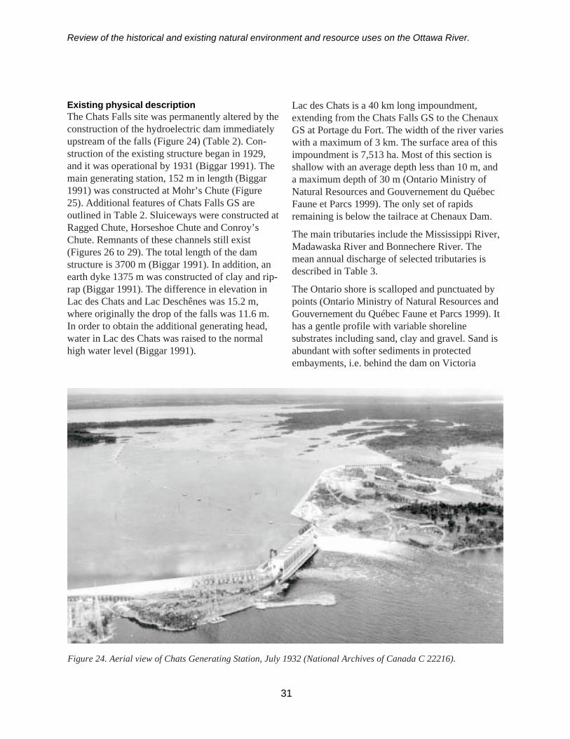
Review of the historical and existing natural environment and resource uses on the Ottawa River.
Existing physical descriptionThe Chats Falls site was permanently altered by theconstruction of the hydroelectric dam immediatelyupstream of the falls (Figure 24) (Table 2). Con-struction of the existing structure began in 1929,and it was operational by 1931 (Biggar 1991). Themain generating station, 152 m in length (Biggar1991) was constructed at Mohr’s Chute (Figure25). Additional features of Chats Falls GS areoutlined in Table 2. Sluiceways were constructed atRagged Chute, Horseshoe Chute and Conroy’sChute. Remnants of these channels still exist(Figures 26 to 29). The total length of the damstructure is 3700 m (Biggar 1991). In addition, anearth dyke 1375 m was constructed of clay and rip-rap (Biggar 1991). The difference in elevation inLac des Chats and Lac Deschênes was 15.2 m,where originally the drop of the falls was 11.6 m.In order to obtain the additional generating head,water in Lac des Chats was raised to the normalhigh water level (Biggar 1991).
Lac des Chats is a 40 km long impoundment,extending from the Chats Falls GS to the ChenauxGS at Portage du Fort. The width of the river varieswith a maximum of 3 km. The surface area of thisimpoundment is 7,513 ha. Most of this section isshallow with an average depth less than 10 m, anda maximum depth of 30 m (Ontario Ministry ofNatural Resources and Gouvernement du QuébecFaune et Parcs 1999). The only set of rapidsremaining is below the tailrace at Chenaux Dam.
The main tributaries include the Mississippi River,Madawaska River and Bonnechere River. Themean annual discharge of selected tributaries isdescribed in Table 3.
The Ontario shore is scalloped and punctuated bypoints (Ontario Ministry of Natural Resources andGouvernement du Québec Faune et Parcs 1999). Ithas a gentle profile with variable shorelinesubstrates including sand, clay and gravel. Sand isabundant with softer sediments in protectedembayments, i.e. behind the dam on Victoria
31
Figure 24. Aerial view of Chats Generating Station, July 1932 (National Archives of Canada C 22216).

Review of the historical and existing natural environment and resource uses on the Ottawa River.
Island, and deeper sections of the river. TheQuébec shoreline is much more irregular, marshyand dotted with islands. There is a concentration ofislands 5 km below Chenaux GS.
Present hydrologyThe drainage area of Chats Falls is 89,600 km2.The mean annual discharge is 1,144 m3/s, (Telmer1996) rising at times of flooding to 6,230 m3/s andfalling as low as 350 m3/s (Biggar 1991).
Water levels are maintained relatively consistentthroughout the year with the exception of the 0.34m increase on average during the spring freshet(Figure 30).
Figure 29. Current view of log chute at Chats Falls,2000.
32
Figure 25. Chats Generating Station, 2000.
Figure 26. Sluice gates and ancient waterway atRagged Chute, 2000.
Figure 27. Sluice gates and structures at HorseshoeChute, 2000.
Figure 28. Sluice gates and ancient waterway atConroy’s Chute, 2000.
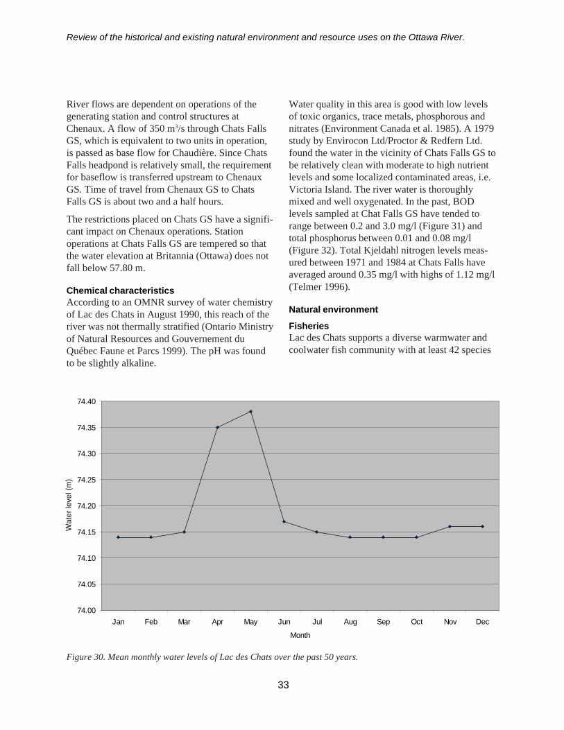
Review of the historical and existing natural environment and resource uses on the Ottawa River.
River flows are dependent on operations of thegenerating station and control structures atChenaux. A flow of 350 m3/s through Chats FallsGS, which is equivalent to two units in operation,is passed as base flow for Chaudière. Since ChatsFalls headpond is relatively small, the requirementfor baseflow is transferred upstream to ChenauxGS. Time of travel from Chenaux GS to ChatsFalls GS is about two and a half hours.
The restrictions placed on Chats GS have a signifi-cant impact on Chenaux operations. Stationoperations at Chats Falls GS are tempered so thatthe water elevation at Britannia (Ottawa) does notfall below 57.80 m.
Chemical characteristicsAccording to an OMNR survey of water chemistryof Lac des Chats in August 1990, this reach of theriver was not thermally stratified (Ontario Ministryof Natural Resources and Gouvernement duQuébec Faune et Parcs 1999). The pH was foundto be slightly alkaline.
33
Water quality in this area is good with low levelsof toxic organics, trace metals, phosphorous andnitrates (Environment Canada et al. 1985). A 1979study by Envirocon Ltd/Proctor & Redfern Ltd.found the water in the vicinity of Chats Falls GS tobe relatively clean with moderate to high nutrientlevels and some localized contaminated areas, i.e.Victoria Island. The river water is thoroughlymixed and well oxygenated. In the past, BODlevels sampled at Chat Falls GS have tended torange between 0.2 and 3.0 mg/l (Figure 31) andtotal phosphorus between 0.01 and 0.08 mg/l(Figure 32). Total Kjeldahl nitrogen levels meas-ured between 1971 and 1984 at Chats Falls haveaveraged around 0.35 mg/l with highs of 1.12 mg/l(Telmer 1996).
Natural environment
FisheriesLac des Chats supports a diverse warmwater andcoolwater fish community with at least 42 species
Figure 30. Mean monthly water levels of Lac des Chats over the past 50 years.
74.00
74.05
74.10
74.15
74.20
74.25
74.30
74.35
74.40
Jan Feb Mar Apr May Jun Jul Aug Sep Oct Nov Dec
Month
Wat
er le
vel (
m)

Review of the historical and existing natural environment and resource uses on the Ottawa River.
documented in this reach (Appendix 1). Walleye,smallmouth bass, northern pike, yellow perch, andmuskellunge are the major game species in thisreach (Table 3). Netting efforts have shown thatchannel catfish are the most abundant species inthis reach of river (Haxton 1999). Other speciesprevalent include brown bullheads, yellowbullheads, redhorse species, and longnose gar.Lake sturgeon numbers are considered to be low inthis reach and American eels are occasionally stillsampled (Appendix 1).
An Envirocon Ltd/Proctor & Redfern Ltd. (1979)study of the Chats Falls area found 19 fish specieswith minnows, perch, and catfish being the preva-lent species. Walleye spawn in the tailrace ofChenaux GS, below the weir in the MadawaskaRiver, Galetta Dam in the Mississippi River,around the islands in the middle of the river and in
the Bonnechere River. Pike spawn in Rhoddy’sand Marshall Bays and the mouth of theBonnechere River. Muskellunge have been docu-mented spawning along the north shore of the riverin this reach.
There is little fishing in the forebay due to accessthrough the narrows upstream at Lavergne Point,but there is greater fishing pressure in back baysupstream of the Chats Falls Generating Station.Fishing pressure is not as great in the Braeside/Arnprior area as in other areas.
The Arnprior Fish and Game Club conduct anannual opening day walleye creel census below theweir on the Madawaska River (Ontario Ministry ofNatural Resources and Gouvernement du QuébecFaune et Parcs 1999). Considerable angling occurshere and at the Chenaux tailrace during the earlyseason. There have been some complaints from
Figure 31. Biological Oxygen Demand levels at Chats Falls (1966-2001).
34
0.0
1.0
2.0
3.0
4.0
5.0
6.019
66-0
4-19
1967
-06-
06
1968
-08-
09
1969
-10-
01
1970
-07-
07
1971
-03-
22
1973
-01-
09
1974
-09-
16
1976
-05-
03
1977
-09-
13
1978
-06-
12
1986
-05-
12
1987
-12-
15
1991
-05-
27
1992
-06-
23
1993
-07-
12
1994
-05-
31
1995
-06-
20
1996
-11-
26
1998
-02-
24
1998
-11-
24
2000
-04-
18
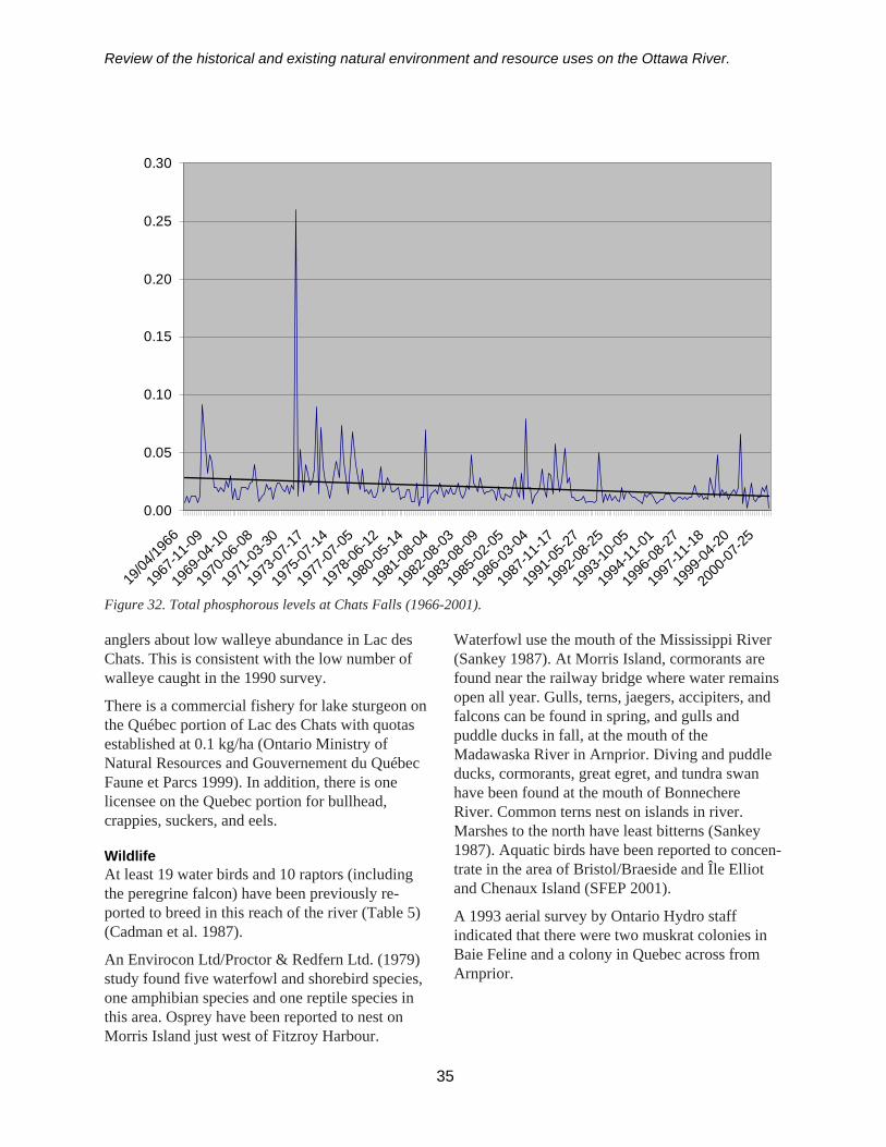
Review of the historical and existing natural environment and resource uses on the Ottawa River.
Figure 32. Total phosphorous levels at Chats Falls (1966-2001).
anglers about low walleye abundance in Lac desChats. This is consistent with the low number ofwalleye caught in the 1990 survey.
There is a commercial fishery for lake sturgeon onthe Québec portion of Lac des Chats with quotasestablished at 0.1 kg/ha (Ontario Ministry ofNatural Resources and Gouvernement du QuébecFaune et Parcs 1999). In addition, there is onelicensee on the Quebec portion for bullhead,crappies, suckers, and eels.
WildlifeAt least 19 water birds and 10 raptors (includingthe peregrine falcon) have been previously re-ported to breed in this reach of the river (Table 5)(Cadman et al. 1987).
An Envirocon Ltd/Proctor & Redfern Ltd. (1979)study found five waterfowl and shorebird species,one amphibian species and one reptile species inthis area. Osprey have been reported to nest onMorris Island just west of Fitzroy Harbour.
Waterfowl use the mouth of the Mississippi River(Sankey 1987). At Morris Island, cormorants arefound near the railway bridge where water remainsopen all year. Gulls, terns, jaegers, accipiters, andfalcons can be found in spring, and gulls andpuddle ducks in fall, at the mouth of theMadawaska River in Arnprior. Diving and puddleducks, cormorants, great egret, and tundra swanhave been found at the mouth of BonnechereRiver. Common terns nest on islands in river.Marshes to the north have least bitterns (Sankey1987). Aquatic birds have been reported to concen-trate in the area of Bristol/Braeside and Île Elliotand Chenaux Island (SFEP 2001).
A 1993 aerial survey by Ontario Hydro staffindicated that there were two muskrat colonies inBaie Feline and a colony in Quebec across fromArnprior.
35
0.00
0.05
0.10
0.15
0.20
0.25
0.30
19/04
/1966
1967
-11-09
1969
-04-10
1970
-06-08
1971
-03-30
1973
-07-17
1975
-07-14
1977
-07-05
1978
-06-12
1980
-05-14
1981
-08-04
1982
-08-03
1983
-08-09
1985
-02-05
1986
-03-04
1987
-11-17
1991
-05-27
1992
-08-25
1993
-10-05
1994
-11-01
1996
-08-27
1997
-11-18
1999
-04-20
2000
-07-25
Review of the historical and existing natural environment and resource uses on the Ottawa River.
utilities and waste treatment plants. The town ofBraeside, with its Tembec Mill, is a major wateruser. It also has a public beach.
There is a proposed boat bypass at the northern-most sluice/dam at Chats Falls on the Québec sidewith another proposed bypass through FitzroyHarbour and Laverge Point. There is a canoeportage route around the Chats Falls GS. Access isvia the south side of the Victoria Island sluiceway.
This reach is second to the Lac Dollard desOrmeaux reach in agricultural land use in thewatershed with up to 27% of the Mississippi Riversub-basin in agriculture (Table 11) (Telmer 1996).However, there is little in the way of built-up areain this reach.
Lac du Rocher Fendu (Cheneaux to La PasseDam)
Pre-development descriptionChenaux
The Chenaux Rapids were a strong set of rapids,however, were considered insignificant in powerby Thomas Keefer, a prominent civil engineer inthe early 1800s (Kennedy 1970). The rapids weredescribed as a smooth, strong current, which canhardly be termed an interruption in navigation(Sherriff 1831).
Alterations to the river began with the constructionof a log slide in 1839 at Portage du Fort. This logslide was ruined by flood waters during the springof 1840, and was rebuilt in 1841 (Legget 1975).
Originally, the river upstream of Portage du Fortflowed amongst many small islands and containedareas of shallow, fast flowing water (Figure 33).The river had two main channels that flowedaround Limerick Island (Figure 34). The greaterflow of the river was on the Ontario (western) sideof this island (Figure 35; Denis and White 1911).
Bryson
Calumet Falls and accompanying rapids extendedover 1.6 km and dropped 18.2 m (Kennedy 1970)through a rocky gorge interspaced with a number
Twenty-two amphibians and reptiles have beenreported in this reach (Table 6) (Oldham andWeller 2000).
Unique speciesThere are a few unique or less common species inthis reach of the river. Two vulnerable species(red-shouldered hawk and river redhorse) havebeen reported in this reach of the river (Table 7)(OMNR 2001). A grasshopper sparrow has beenreported in Baie à John. Some of the highestconcentrations of common map turtles have beenfound in this reach (Daigle et al. 1994).
Wetlands, parks, and environmentally sensitiveareasThere are four provincially significant wetlands inthis section of river: the Mississippi Snye Wetland;Morris Island Wetland on the west/central shore ofMorris Island; Nopoming Wetland; and theBonnechere River Marsh (Table 8) (OMNR2001a). A large wetland, located across the riverfrom Braeside is an ecological reserve, Projet duRefuge Faunique de Bristol (SFEP 2001).
Life science ANSIs are found on Victoria Islandand the Mississippi Syne (Table 9) (OMNR2001a). The Victoria Island ANSI centres on theremains of a timber slide constructed on the islandin 1835 (Fourier 1979).
There are public beaches/parks in Arnprior on boththe east and west shores of the Madawaska Rivermouth.
Shoreline developmentMost of the Ontario shoreline is privately ownedand occupied by over 450 cottages and homes inthis section of the river (based on review of topo-graphic and Ontario base maps). Year roundcottage habitation is increasing. Since 1961,Arnprior, another major user of the river, hasexperienced an increase, i.e. 30%, in population(Ontario Water Resources Commission andQuébec Water Board 1972; Statistics Canada2001) (Table 10). There is a federal dock/boatlaunch at Arnprior. There are ongoing proposalsfor large-scale works, including marinas, beaches,
36
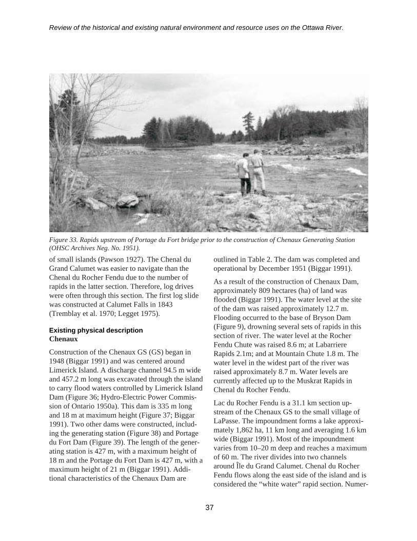
Review of the historical and existing natural environment and resource uses on the Ottawa River.
of small islands (Pawson 1927). The Chenal duGrand Calumet was easier to navigate than theChenal du Rocher Fendu due to the number ofrapids in the latter section. Therefore, log driveswere often through this section. The first log slidewas constructed at Calumet Falls in 1843(Tremblay et al. 1970; Legget 1975).
Existing physical descriptionChenaux
Construction of the Chenaux GS (GS) began in1948 (Biggar 1991) and was centered aroundLimerick Island. A discharge channel 94.5 m wideand 457.2 m long was excavated through the islandto carry flood waters controlled by Limerick IslandDam (Figure 36; Hydro-Electric Power Commis-sion of Ontario 1950a). This dam is 335 m longand 18 m at maximum height (Figure 37; Biggar1991). Two other dams were constructed, includ-ing the generating station (Figure 38) and Portagedu Fort Dam (Figure 39). The length of the gener-ating station is 427 m, with a maximum height of18 m and the Portage du Fort Dam is 427 m, with amaximum height of 21 m (Biggar 1991). Addi-tional characteristics of the Chenaux Dam are
37
Figure 33. Rapids upstream of Portage du Fort bridge prior to the construction of Chenaux Generating Station(OHSC Archives Neg. No. 1951).
outlined in Table 2. The dam was completed andoperational by December 1951 (Biggar 1991).
As a result of the construction of Chenaux Dam,approximately 809 hectares (ha) of land wasflooded (Biggar 1991). The water level at the siteof the dam was raised approximately 12.7 m.Flooding occurred to the base of Bryson Dam(Figure 9), drowning several sets of rapids in thissection of river. The water level at the RocherFendu Chute was raised 8.6 m; at LabarriereRapids 2.1m; and at Mountain Chute 1.8 m. Thewater level in the widest part of the river wasraised approximately 8.7 m. Water levels arecurrently affected up to the Muskrat Rapids inChenal du Rocher Fendu.
Lac du Rocher Fendu is a 31.1 km section up-stream of the Chenaux GS to the small village ofLaPasse. The impoundment forms a lake approxi-mately 1,862 ha, 11 km long and averaging 1.6 kmwide (Biggar 1991). Most of the impoundmentvaries from 10–20 m deep and reaches a maximumof 60 m. The river divides into two channelsaround Île du Grand Calumet. Chenal du RocherFendu flows along the east side of the island and isconsidered the “white water” rapid section. Numer-

Review of the historical and existing natural environment and resource uses on the Ottawa River.
Figure 34. Aerial mosaic of Lac du Rocher Fendu priorto the construction of the Chenaux Generating Station.
Figure 35. Historical view of the rapids where Chenaux Generating Station was constructed. View is from the easton Limerick Island (OHSC Archive Neg. No. 1947).
Figure 36. The overflow channel constructed throughLimerick Island (2000).
38
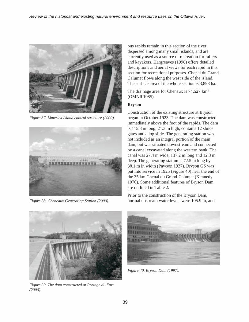
Review of the historical and existing natural environment and resource uses on the Ottawa River.
Figure 37. Limerick Island control structure (2000).
Figure 38. Cheneaux Generating Station (2000).
Figure 39. The dam constructed at Portage du Fort(2000).
ous rapids remain in this section of the river,dispersed among many small islands, and arecurrently used as a source of recreation for raftersand kayakers. Hargreaves (1998) offers detaileddescriptions and aerial views for each rapid in thissection for recreational purposes. Chenal du GrandCalumet flows along the west side of the island.The surface area of the whole section is 3,893 ha.
The drainage area for Chenaux is 74,527 km2
(OMNR 1985).
Bryson
Construction of the existing structure at Brysonbegan in October 1923. The dam was constructedimmediately above the foot of the rapids. The damis 115.8 m long, 21.3 m high, contains 12 sluicegates and a log slide. The generating station wasnot included as an integral portion of the maindam, but was situated downstream and connectedby a canal excavated along the western bank. Thecanal was 27.4 m wide, 137.2 m long and 12.3 mdeep. The generating station is 72.5 m long by38.1 m in width (Pawson 1927). Bryson GS wasput into service in 1925 (Figure 40) near the end ofthe 35 km Chenal du Grand-Calumet (Kennedy1970). Some additional features of Bryson Damare outlined in Table 2.
Prior to the construction of the Bryson Dam,normal upstream water levels were 105.9 m, and
Figure 40. Bryson Dam (1997).
39

Review of the historical and existing natural environment and resource uses on the Ottawa River.
maximum flood were 107.2 m. The maximumelevation of the pond level after the completion ofthe dam was 107.2 m (Pawson 1927).
A dam was built in the Chenal du Rocher Fendubetween Sullivan Island and Calumet Island toraise the water for a canal on Culbute channel onthe north side of Allumette Island. It was originallycompleted in 1876 (Kennedy 1970). The existingstructure now serves to ensure there is sufficientflow to the Bryson GS (Hargreaves 1998).
The drainage area for Bryson Dam is 74,281 km2
(OMNR 1985).
Both shorelines are very irregular (Ontario Minis-try of Natural Resources and Gouvernement duQuébec Faune et Parcs 1999). Points and bays arenumerous. The white water area flows mainlythrough bedrock. Shorelines rise abruptly andislands are numerous. Lac du Rocher Fendu has amore gentle contour. Shoreline substrates includesand, silt, clay, gravel, and rock outcrops. There
40
are clay banks up to 10 m high on the upper end ofthe impoundment.
Present hydrologyMost of Lac du Rocher Fendu varies from 10–20 min depth (Ontario Ministry of Natural Resourcesand Gouvernement du Québec Faune et Parcs1999). The upper third of this impoundment isdeeper and reaches a maximum depth of 60 m.
The Chenaux GS is used as a peaking station and issubjected to extreme water fluctuations within a 24 hrperiod. However, the mean monthly variation isnot that great (Figure 41). The average annualdrawdown is 1.6 m, where the maximumdrawdown is 1.9 m (Efford 1975). Station flowsare regulated hourly (daily cycling) to match powerdemand. The average daily discharge must beequal or greater than the Lake Temiscamingaverage discharge of two days prior plus 40 m3/s.A flow change due to Des Joachims will be seen atChenaux two and a half days later.
Figure 41. Mean monthly water levels in Lac du Rocher Fendu over the past 50 years.
85.95
86.00
86.05
86.10
86.15
86.20
86.25
86.30
86.35
86.40
Jan Feb Mar Apr May Jun Jul Aug Sep Oct Nov Dec
Month
Wat
er le
vel

Review of the historical and existing natural environment and resource uses on the Ottawa River.
Spillage to the Portage du Fort Dam and theLimerack Island Dam generally occurs during peakflows from mid-April throughout May when riverflows exceed 1250 m3/s.
Chemical characteristicsHigher than normal concentrations of metals suchas copper, zinc, nickel, and lead have historicallybeen noted in this reach (Environment Canada etal. 1985). In the past, BOD levels sampled atChenaux GS have tended to range between 0.25and 3.0 mg/l (Figure 42) and total phosphorusbetween 0.01 and 0.04 mg/l (Figure 43). TotalKjeldahl nitrogen levels measured between 1978and 1985 at Chenaux have averaged around 0.25mg/l with highs of 0.4 mg/l (Telmer 1996).
Natural environment
FisheriesThis reach of the river supports a diversecoolwater/warmwater fisheries with at least 25species documented (Appendix 1). Walleye,
smallmouth bass, northern pike, and sauger aresome of the common sport species (Table 4).Channel catfish are the most abundant species inthis section of river based on recent assessmentnetting (Haxton 1998 and OMNR 2000). Otherspecies present include brown bullhead, redhorsespecies, and lake sturgeon (Table 4). Americaneels have not been sampled in this reach in recentyears. A freshwater drum was sampled in 2000(Appendix 1).
Walleye are known to spawn in the remainingnatural rapids, at the outflow of Canal du GrandCalumet and below Bryson Dam. A recent radiote-lemetry study on the movement of walleye in Lacdu Rocher Fendu revealed that the rapids in theupper section of this reach are not a natural barrierto this species’ upstream migration (Kirby Punt,pers com). Lake sturgeon historically spawnednear the islands upstream of Portage du Fort, butthese areas were flooded after the construction ofthe Chenaux Dam.
41
Figure 42. Biological Oxygen Demand levels at Chenaux, 1968 - 2000.
0.00
0.50
1.00
1.50
2.00
2.50
3.00
3.50
4.00
1968
-05-
02
1969
-01-
20
1969
-12-
16
1970
-07-
07
1971
-05-
04
1971
-11-
23
1972
-06-
28
1973
-02-
13
1974
-03-
26
1975
-01-
22
1975
-09-
24
1976
-08-
11
1977
-06-
16
1979
-04-
26
1986
-08-
05
1988
-04-
19
1989
-06-
13
1990
-05-
15
1991
-05-
27
1992
-07-
14
1993
-08-
17
1994
-09-
20
1995
-09-
27
1999
-10-
07
2000
-08-
14

Review of the historical and existing natural environment and resource uses on the Ottawa River.
There is a commercial fishery for lake sturgeon inthis reach licensed out of Québec with a quota of0.1 kg/ha (Ontario Ministry of Natural Resourcesand Gouvernement du Québec Faune et Parcs1999).
WildlifeAt least 14 water birds and four raptors (includingthe Cooper’s hawk) have been reported to breed inthis reach of the river (Table 5) (Cadman et al.1987). Waterfowl concentrations have been re-ported downstream of Bryson and in Lac duRocher Fendu during migrations.
A 1993 aerial survey by Ontario Hydro staffindicated that there were several muskrat colonieslocated along the Chenal du Grand Calumet down-stream of La Passe.
Fifteen species of amphibians and reptiles havebeen reported in this reach (Table 6) (Oldham andWeller 2000).
Unique speciesThere are a few unique or less common species inthis reach of the river. There are reports of watersnakes near Sullivan Island (Table 7). The ram’shead lady slipper has been reported near Bryson.Some of the highest concentrations of commonmap turtles have been found in this reach (Daigleet al.1994).
Wetlands, parks, and environmentally sensitiveareasIn this reach of the river there are wetlands locatedat Hazelton and Lorne Islands and Killoray Bay.
A 125 ha section of the Ottawa River downstreamof La Passe has been designated a ProvincialWaterway Park due to its untouched shoreline andwhite water characteristics (Table 9).
Shoreline developmentThree commercial white water rafting outfitters runexpeditions on this section of river with two, OwlRafting and Wilderness Tours, having lodgings and
42
Figure 43. Total phosphorous levels at Chenaux, 1968 - 2000.
0.00
0.02
0.04
0.06
0.08
0.10
0.12
0.14
0.16
0.1819
68-0
5-02
1969
-03-
1319
70-0
4-14
1971
-03-
3019
72-0
1-11
1972
-09-
1119
73-1
0-24
1975
-01-
22
1976
-03-
3019
77-0
1-26
1978
-12-
06
1980
-08-
1119
81-0
8-03
1982
-06-
01
1983
-03-
0119
84-0
1-09
1985
-08-
06
1986
-11-
0319
88-0
4-19
1989
-08-
14
1990
-10-
1619
92-0
6-02
1993
-09-
14
1994
-11-
2919
96-1
0-03
2000
-07-
04

Review of the historical and existing natural environment and resource uses on the Ottawa River.
associated recreational facilities based at BycesPoint. Consolidated Bathurst established a papermill at Portage du Fort in 1966. Bryson has a pulpand paper mill as well.
There are municipal drinking water systemsdownstream of La Passe, including Bryson andCampbell’s Bay.
Since 1961, some communities have experienced adecline in population, e.g. Campbell’s Bay, whileothers have increased in size, Ontario WaterResources Commission and Quebec Water Board1972; Statistics Canada 2001) (Table 10).
Allumette Lake and Lac Coulonge (LaPasse toDes Joachims)
Pre-development descriptionThis reach of river extends approximately 90 kmand consists of several “lakes” separated by shortrapids (Ontario Ministry of Natural Resources andGouvernement du Québec Faune et Parcs 1999)(Figure 1). Aside from development along theshoreline, this reach of river remains much thesame as it was prior to hydroelectric development(Legget 1975). The shoreline remains relativelyunaltered due to the construction of hydraulicstructures (Ottawa River Engineering Board 1965).
Existing physical descriptionThe “lakes” (reaches) include Lac Coulonge,Lower Allumette Lake and Upper Allumette Lake.Lac Coulonge is 18.1 km in length, with a surfacearea of 2,888 ha. The Rapides Paquette and aconcentration of islands separate Lac Coulongeand Lower Allumette Lake. The Ottawa Riverflows around both sides of Île des Allumettes.Chenal de la Culbute is the smaller channel withseveral sets of rapids, Rapides de la Culbute,Rapides de l’Islet and Rapides du Chapeau, thatflows 21.8 km along the north side of the island.Lake-like conditions exist along the southern sideof Île des Allumettes. Lower Allumette is approxi-mately 22.3 km long, with a surface area of 4,613 ha.
Lower Allumette and Upper Allumette are sepa-rated by three sets of rapids, Rapides des
Allumette, Lost Channel and Beckett Island Rap-ids, located amongst islands immediatelydownstream of the interprovincial bridge. TheUpper Allumette Section is 76.9 km long with asurface area of 18,212 ha. The river is relativelycalm upstream of the inter-provincial bridge exceptnear Petawawa where there are numerous islands.Depths average 10–15 m in Allumette Lake. ThePetawawa area is particularly shallow. From theDeep River Inlet / Pointe Malin to Rolphton /Rapides des Joachims, the river is deep reaching amaximum of over 60 m. Surveys in 1991 deter-mined that this section thermally stratifies (OntarioMinistry of Natural Resources and Gouvernementdu Québec Faune et Parcs 1999).
The main tributaries in this section of river includeRivière Coulonge, Rivière Noire, Muskrat River,Petawawa River and Schyan River. The meanannual discharge of selected tributaries is describedin Table 3.
Both shorelines are scalloped and punctuated bypoints (Ontario Ministry of Natural Resources andGouvernement du Québec Faune et Parcs 1999).The lower part of the reach has a low gradient withvariable shoreline substrates including silt, sand,clay, gravel and occasional rock outcrops. Sandpredominates in the Petawawa area. Steep granitecliffs dominate the Québec shoreline from PointeMalin to Rapides des Joachims.
Present hydrologyThe water levels in this section are quasi-natural.The level is affected by the flow of water which isregulated upstream by the Des Joachims Generat-ing Station. Water levels in Allumette Lake fluctuateon average 0.72 m, from a high of 111.91 m in Mayto a low of 111.19 m in September (Figure 44).
Chemical characteristicsOMNR surveyed the water chemistry of LowerAllumette Lake, near Westmeath, in 1970 (OntarioMinistry of Natural Resources and Gouvernementdu Québec Faune et Parcs 1999). This reach wasnot thermally stratified due to the high flushing ratethat prevents stratification. pH at survey stations
43

Review of the historical and existing natural environment and resource uses on the Ottawa River.
was neutral. Conductivity was measured at65 µhos/cm in the fall of 1997.
Natural environment
FisheriesThis reach supports diverse warmwater andcoolwater fish communities with at least 55 speciesdocumented (Appendix 1). Walleye is the mainspecies sought by anglers. Catches typicallyinclude walleye, pike, channel catfish, smallmouthbass, and lake sturgeon. Walleye anglers concen-trate their effort near the Highway 148 bridge, ÎleLeblanc (“lighthouse”), Petawawa and Schyanriver mouths, and Rolphton/Rapides Des Joachims.There is a small trophy muskie fishery nearPetawawa. Several walleye, bass, and multi-species tournaments and derbies occur during theyear. Catches during the bass derby are typicallyhalf of those in southern Ontario derbies.
American eels were one time considered abundantin this section of river, such that this speciesdominated the bones found in archaeological digson Morrison Island (Pilon 1999). Eels have notbeen sampled in this reach in recent assessmentefforts. Channel catfish are the most abundantspecies in these reaches (Haxton 2000a, 2000b;
OMNR 2001b). Lake sturgeon numbers are thegreatest in this reach when compared to the otherreaches of the Ottawa River (Haxton in review).
An early season access creel in 1993 on the On-tario side of Allumette Lake estimated an effort of25,120 angler hours in the first six weeks of theseason, harvesting an estimated 6,348 walleye(Haxton 1997).
Lake trout were introduced in the Deep River areain 1993 and stocked for three years to use coldwater habitat located there. However, a nettingassessment in 1996 targeted at lake trout failed tosample any returns and very few reports of laketrout being caught have been received.
Walleye spawn in areas of natural rapids through-out the reach, in tributaries of the river, amongstthe islands off Petawawa Point and below DesJoachims Dam. Muskellunge have been observedat the delta of the Petawawa River. Lake sturgeonare known to spawn in the Allumette Rapids and asmall tributary near McConnell Lake. Suckersspawn in most tributaries and natural rapids.
There is a commercial fishery for lake sturgeonlicensed out of Quebec with a quota of 0.1 kg/ha of
44
Figure 44. Mean monthly water levels in Allumette Lake over the past 50 years.
110.8
111.0
111.2
111.4
111.6
111.8
112.0
Jan Feb Mar Apr May Jun Jul Aug Sep Oct Nov Dec
Month
Wat
er L
evel
(m)

Review of the historical and existing natural environment and resource uses on the Ottawa River.
Québec water. There is also a commercial fisheryfor bullhead, crappie, suckers, and eels based outof Québec.
WildlifeAt least 34 species of water birds and 11 raptors(including the peregrine falcon, Cooper’s hawk,and merlin) have been previously reported to breedin this reach of the river (Table 5) (Cadman et al.1987). Peregrine falcons are known to nest on thecliffs across from Chalk River.
Heron colonies are reported near Rapides de laCulbute, Deep River, and Rapides-des-Joachims(Sankey 1987). Herring and ring-billed gulls neston islands in Allumette Lake between Pembrokeand Petawawa.
Waterfowl concentrations have been reported atLac Nanny, Bellows Bay, Lac Downey, and PointeSeche. Westmeath Provincial Park (Bellow’s Bay)has had a diversity of waterfowl, peregrines fal-cons, and ospreys (Sankey 1987). It has served as aspring staging area for numerous diving anddabbling ducks including the ring-necked duck,bufflehead, and hooded merganser (Michener1996). Nearby O’Brien Bay is open all winter andhas been used by common goldeneye (Sankey1987). Rapids north of Morrison Island havewaterfowl in the fall e.g. commin goldeneye(Sankey 1987). Its open waters during the winterhave attracted common merganser, commongoldeneye, Barrow’s goldeneye, and harlequinduck (Michener 1996). Bald eagle, commonmerganser, common goldeneye, and gulls havebeen sighted in the open water around Rapides-des-Joachims during the winter (Michener 1996).Also, bald eagles have been sighted at Deep Riverand Petawawa, and gyrfalcons at Deep River(Michener 1996).
Goodwin (1995) noted that the largest recordedswallow roost in Ontario was sited at the conflu-ence of the Muskrat and Ottawa Rivers atPembroke in 1983. Although it no longer exists, all
six species of swallows, and merlins, had beenfound at this roost.
A 1993 aerial survey by Ontario Hydro staffindicated that there were several muskrat coloniesin the vicinity of La Passe.
Twenty-six species of amphibians and reptileshave been reported in this reach (Table 6) (Oldhamand Weller 2000; Coulson pers comm6).
Unique speciesThere are a number of unique or less commonspecies in this reach of the river. Cryptandusdropseed, Smith’s club-rush and Torrey’s bulrushhave been found in the area of Fort Coulonge(Table 7). Bald rush has been reported to occurnear Île Leblanc and Douglas buckwheat at Rocheà l’Oiseau.
Wood turtles have been found in Welch Bay nearDeep River and Fort Coulonge, map turtles nearÎles Finlay, and spiny softshell turtles (a threatenedspecies) near Îles Finlay and Fort William. Per-egrine falcons have been observed at Pointe àl’Oiseau downstream of Deep River.
Other less common species such as the sandhillcrane, western sandpiper, stilt sandpiper, leastbittern, tundra swan, ruddy duck, pomarine jaeger,parasitic jaeger, laughing gull, sabine’s gull,Caspian tern, northern hawk owl, great gray owl,and long-eared owl have been sighted at DeepRiver, and long-tailed duck, buff-breasted sandpi-per, short-eared owl, and boreal owl in Pembroke(Michener 1996).
Wetlands, parks, and environmentally sensitiveareasThe Ontario side of this reach contains two provin-cially significant wetlands: Bellow’s Bay,HazleyBay/Lisk Bay Complex (Table 8) (OMNR2001a). Wetlands in this reach which may beprovincially significant include Hales Creek,Hennessy’s Bay, Malloy Bay, and Lacroix Bay.Other wetlands include Baie Downey, Fort
45
6 Daryl Coulson, District Ecologist, Pembroke District.
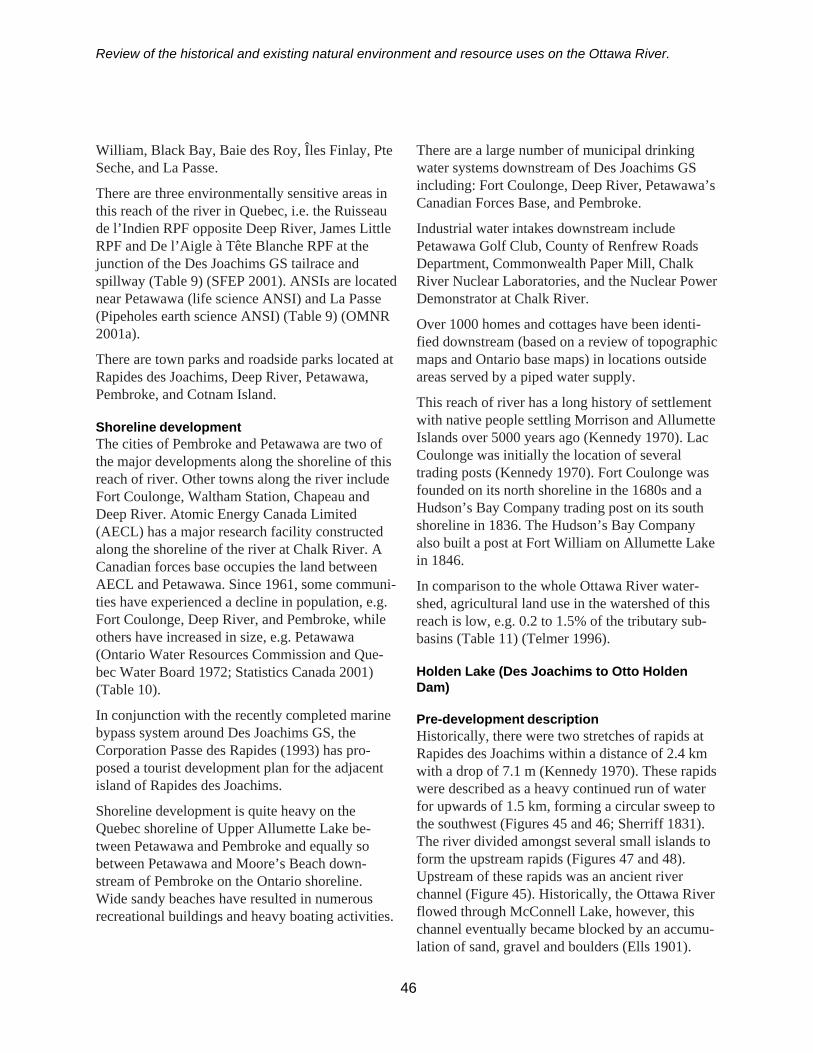
Review of the historical and existing natural environment and resource uses on the Ottawa River.
William, Black Bay, Baie des Roy, Îles Finlay, PteSeche, and La Passe.
There are three environmentally sensitive areas inthis reach of the river in Quebec, i.e. the Ruisseaude l’Indien RPF opposite Deep River, James LittleRPF and De l’Aigle à Tête Blanche RPF at thejunction of the Des Joachims GS tailrace andspillway (Table 9) (SFEP 2001). ANSIs are locatednear Petawawa (life science ANSI) and La Passe(Pipeholes earth science ANSI) (Table 9) (OMNR2001a).
There are town parks and roadside parks located atRapides des Joachims, Deep River, Petawawa,Pembroke, and Cotnam Island.
Shoreline developmentThe cities of Pembroke and Petawawa are two ofthe major developments along the shoreline of thisreach of river. Other towns along the river includeFort Coulonge, Waltham Station, Chapeau andDeep River. Atomic Energy Canada Limited(AECL) has a major research facility constructedalong the shoreline of the river at Chalk River. ACanadian forces base occupies the land betweenAECL and Petawawa. Since 1961, some communi-ties have experienced a decline in population, e.g.Fort Coulonge, Deep River, and Pembroke, whileothers have increased in size, e.g. Petawawa(Ontario Water Resources Commission and Que-bec Water Board 1972; Statistics Canada 2001)(Table 10).
In conjunction with the recently completed marinebypass system around Des Joachims GS, theCorporation Passe des Rapides (1993) has pro-posed a tourist development plan for the adjacentisland of Rapides des Joachims.
Shoreline development is quite heavy on theQuebec shoreline of Upper Allumette Lake be-tween Petawawa and Pembroke and equally sobetween Petawawa and Moore’s Beach down-stream of Pembroke on the Ontario shoreline.Wide sandy beaches have resulted in numerousrecreational buildings and heavy boating activities.
There are a large number of municipal drinkingwater systems downstream of Des Joachims GSincluding: Fort Coulonge, Deep River, Petawawa’sCanadian Forces Base, and Pembroke.
Industrial water intakes downstream includePetawawa Golf Club, County of Renfrew RoadsDepartment, Commonwealth Paper Mill, ChalkRiver Nuclear Laboratories, and the Nuclear PowerDemonstrator at Chalk River.
Over 1000 homes and cottages have been identi-fied downstream (based on a review of topographicmaps and Ontario base maps) in locations outsideareas served by a piped water supply.
This reach of river has a long history of settlementwith native people settling Morrison and AllumetteIslands over 5000 years ago (Kennedy 1970). LacCoulonge was initially the location of severaltrading posts (Kennedy 1970). Fort Coulonge wasfounded on its north shoreline in the 1680s and aHudson’s Bay Company trading post on its southshoreline in 1836. The Hudson’s Bay Companyalso built a post at Fort William on Allumette Lakein 1846.
In comparison to the whole Ottawa River water-shed, agricultural land use in the watershed of thisreach is low, e.g. 0.2 to 1.5% of the tributary sub-basins (Table 11) (Telmer 1996).
Holden Lake (Des Joachims to Otto HoldenDam)
Pre-development descriptionHistorically, there were two stretches of rapids atRapides des Joachims within a distance of 2.4 kmwith a drop of 7.1 m (Kennedy 1970). These rapidswere described as a heavy continued run of waterfor upwards of 1.5 km, forming a circular sweep tothe southwest (Figures 45 and 46; Sherriff 1831).The river divided amongst several small islands toform the upstream rapids (Figures 47 and 48).Upstream of these rapids was an ancient riverchannel (Figure 45). Historically, the Ottawa Riverflowed through McConnell Lake, however, thischannel eventually became blocked by an accumu-lation of sand, gravel and boulders (Ells 1901).
46
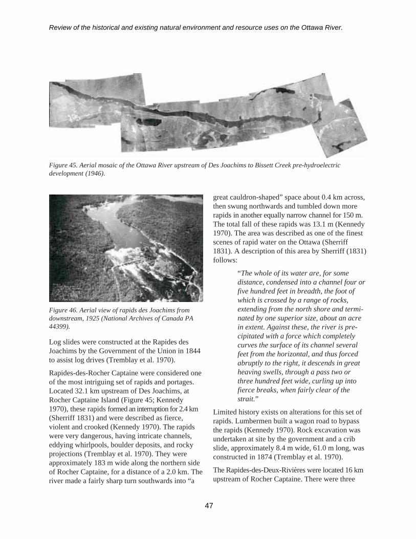
Review of the historical and existing natural environment and resource uses on the Ottawa River.
Figure 45. Aerial mosaic of the Ottawa River upstream of Des Joachims to Bissett Creek pre-hydroelectricdevelopment (1946).
Figure 46. Aerial view of rapids des Joachims fromdownstream, 1925 (National Archives of Canada PA44399).
Log slides were constructed at the Rapides desJoachims by the Government of the Union in 1844to assist log drives (Tremblay et al. 1970).
Rapides-des-Rocher Captaine were considered oneof the most intriguing set of rapids and portages.Located 32.1 km upstream of Des Joachims, atRocher Captaine Island (Figure 45; Kennedy1970), these rapids formed an interruption for 2.4 km(Sherriff 1831) and were described as fierce,violent and crooked (Kennedy 1970). The rapidswere very dangerous, having intricate channels,eddying whirlpools, boulder deposits, and rockyprojections (Tremblay et al. 1970). They wereapproximately 183 m wide along the northern sideof Rocher Captaine, for a distance of a 2.0 km. Theriver made a fairly sharp turn southwards into “a
great cauldron-shaped” space about 0.4 km across,then swung northwards and tumbled down morerapids in another equally narrow channel for 150 m.The total fall of these rapids was 13.1 m (Kennedy1970). The area was described as one of the finestscenes of rapid water on the Ottawa (Sherriff1831). A description of this area by Sherriff (1831)follows:
“The whole of its water are, for somedistance, condensed into a channel four orfive hundred feet in breadth, the foot ofwhich is crossed by a range of rocks,extending from the north shore and termi-nated by one superior size, about an acrein extent. Against these, the river is pre-cipitated with a force which completelycurves the surface of its channel severalfeet from the horizontal, and thus forcedabruptly to the right, it descends in greatheaving swells, through a pass two orthree hundred feet wide, curling up intofierce breaks, when fairly clear of thestrait.”
Limited history exists on alterations for this set ofrapids. Lumbermen built a wagon road to bypassthe rapids (Kennedy 1970). Rock excavation wasundertaken at site by the government and a cribslide, approximately 8.4 m wide, 61.0 m long, wasconstructed in 1874 (Tremblay et al. 1970).
The Rapides-des-Deux-Rivières were located 16 kmupstream of Rocher Captaine. There were three
47
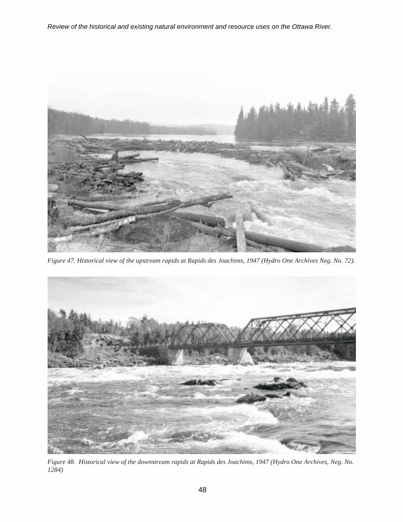
Review of the historical and existing natural environment and resource uses on the Ottawa River.
Figure 48. Historical view of the downstream rapids at Rapids des Joachims, 1947 (Hydro One Archives, Neg. No.1284)
Figure 47. Historical view of the upstream rapids at Rapids des Joachims, 1947 (Hydro One Archives Neg. No. 72).
48
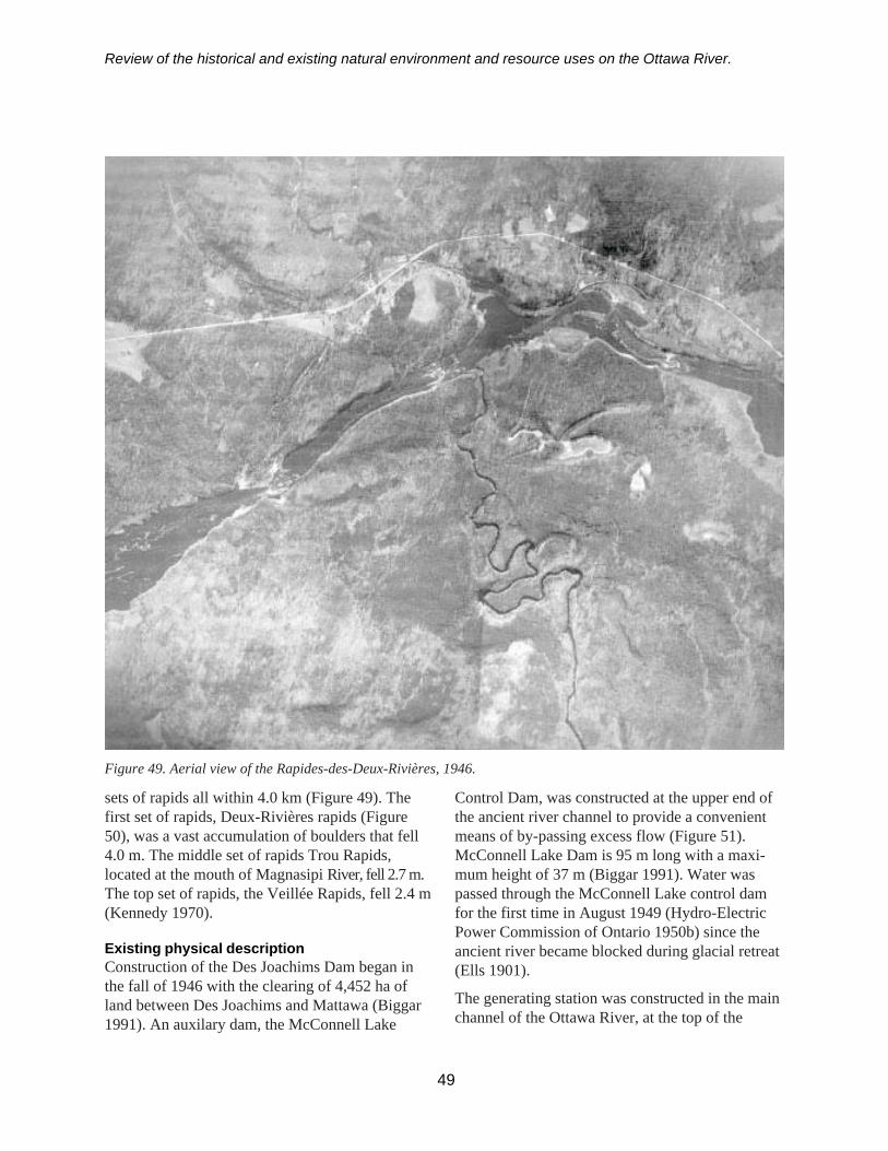
Review of the historical and existing natural environment and resource uses on the Ottawa River.
sets of rapids all within 4.0 km (Figure 49). Thefirst set of rapids, Deux-Rivières rapids (Figure50), was a vast accumulation of boulders that fell4.0 m. The middle set of rapids Trou Rapids,located at the mouth of Magnasipi River, fell 2.7 m.The top set of rapids, the Veillée Rapids, fell 2.4 m(Kennedy 1970).
Existing physical descriptionConstruction of the Des Joachims Dam began inthe fall of 1946 with the clearing of 4,452 ha ofland between Des Joachims and Mattawa (Biggar1991). An auxilary dam, the McConnell Lake
49
Figure 49. Aerial view of the Rapides-des-Deux-Rivières, 1946.
Control Dam, was constructed at the upper end ofthe ancient river channel to provide a convenientmeans of by-passing excess flow (Figure 51).McConnell Lake Dam is 95 m long with a maxi-mum height of 37 m (Biggar 1991). Water waspassed through the McConnell Lake control damfor the first time in August 1949 (Hydro-ElectricPower Commission of Ontario 1950b) since theancient river became blocked during glacial retreat(Ells 1901).
The generating station was constructed in the mainchannel of the Ottawa River, at the top of the

Review of the historical and existing natural environment and resource uses on the Ottawa River.
Rapides des Joachims (Figure 52). The main damis 730 m long and has a maximum height of 37 m.The auxiliary dam is located north of the main damand is 335 m long with a maximum height of 15 m(Biggar 1991). Additional features of the DesJoachims Dam are outlined in Table 2. In order topermit unobstructed flow from the generatingstation, a tailrace channel approximately 2.1 kmlong and 53.3 m wide was excavated through solidrock in the Des Joachims Rapids section of theriver (Hydro-Electric Power Commission ofOntario 1950b). A swift current remains (Figure53) where the lower rapids once raged (Figure 54).
The hydroelectric dam was completed by 1950. Italtered or completely drowned the rapids at DesJoachims, Rocher Captaine and Deux-Rivières,raising water levels all the way to Mattawa(Kennedy 1970; Legget 1975). It flooded an areaapproximately 45.6 km2 (Efford 1975). A lake-likeenvironment was created 92 km in length (Biggar1991), although a swift current is apparent at Klockdue to the narrowing of the channel (Legget 1975).
This section of river currently has an average depthof 30 m with a maximum depth of 150 m offMarabou Point. The main tributaries includeDumoine River, Magnasipi River, and MattawaRiver (Table 3).
Ontario’s shoreline is gently rolling and composedof gravel, cobble and rock outcrops. TheLaurentian Hills rise abruptly from the shoreline of
Figure 50. Historical view from the foot of Deux Rivières rapids pre-hydroelectric development (National Archivesof Canada C 22122).
Figure 51. McConnell Lake Dam (2000).
Figure 52. Des Joachims Dam and tailrace channel(1997).
50

Review of the historical and existing natural environment and resource uses on the Ottawa River.
Québec (Ontario Ministry of Natural Resourcesand Gouvernement du Québec Faune et Parcs1999).
Present hydrologyThere is a winter drawdown of Holden Lake.Water levels generally start to decline in Februaryand are at their lowest in April (Figure 55). Theannual drawdown on average is 2.3 m, with amaximum drawdown of 3.0 m (Efford 1975).Fluctuations immediately downstream of DesJoachims Generating Station are generally a metreor less overnight.
Immediately downstream from Otto Holden Dam,daily water fluctuations may be as much as 1.5 m(Ontario Water Resources Commission and Que-bec Water Board 1971)
51
The drainage area of Des Joachims is 57,500 km2.The mean annual discharge at Des Joachims is 810 m3/s(Telmer 1996).
Chemical characteristicsOMNR staff surveyed the water chemistry ofHolden Lake in 1969 at Driftwood Bay, MooseBay, Klock, and Bissett (Ontario Ministry ofNatural Resources and Gouvernement du QuébecFaune et Parcs 1999). There was no thermalstratification at these survey sites. The pH was 6.5,slightly acidic. Water quality in this reach has beenhistorically influenced by the pulp and paper millupstream at Temiscaming (Environment Canada etal. 1985). Low levels of dissolved oxygen and highlevels of ammonia and nitrate have been reported.
Natural environment
FisheriesThis reach supports a coolwater/warmwater fisherywith at least 36 species documented (Appendix 1).Walleye, sauger, northern pike, and smallmouthbass are the primary game fish present. Otherspecies present include yellow perch, commonwhite suckers, lake whitefish, and burbot (Table 3).Channel catfish are not abundant in this reach.
There was a commercial sturgeon fishery in thisportion of the river near Mattawa until the mid-1970s. Lake sturgeon have declined in this reachand have not been sampled during recent nettingefforts.
Figure 54. View of the lower rapids of Rapids des Joachims from the bridge, 1906 (National Archives of CanadaC4914).
Figure 53. Swift current in the tailrace of Des JoachimsDam (2000).
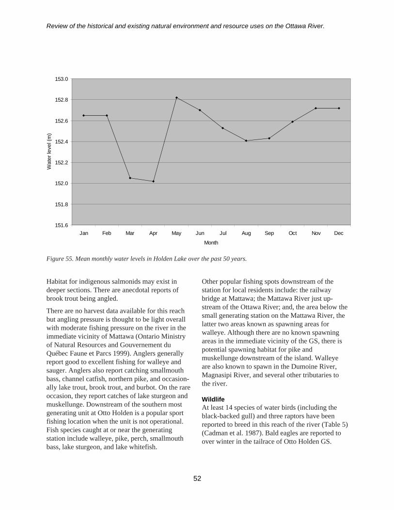
Review of the historical and existing natural environment and resource uses on the Ottawa River.
Habitat for indigenous salmonids may exist indeeper sections. There are anecdotal reports ofbrook trout being angled.
There are no harvest data available for this reachbut angling pressure is thought to be light overallwith moderate fishing pressure on the river in theimmediate vicinity of Mattawa (Ontario Ministryof Natural Resources and Gouvernement duQuébec Faune et Parcs 1999). Anglers generallyreport good to excellent fishing for walleye andsauger. Anglers also report catching smallmouthbass, channel catfish, northern pike, and occasion-ally lake trout, brook trout, and burbot. On the rareoccasion, they report catches of lake sturgeon andmuskellunge. Downstream of the southern mostgenerating unit at Otto Holden is a popular sportfishing location when the unit is not operational.Fish species caught at or near the generatingstation include walleye, pike, perch, smallmouthbass, lake sturgeon, and lake whitefish.
52
Other popular fishing spots downstream of thestation for local residents include: the railwaybridge at Mattawa; the Mattawa River just up-stream of the Ottawa River; and, the area below thesmall generating station on the Mattawa River, thelatter two areas known as spawning areas forwalleye. Although there are no known spawningareas in the immediate vicinity of the GS, there ispotential spawning habitat for pike andmuskellunge downstream of the island. Walleyeare also known to spawn in the Dumoine River,Magnasipi River, and several other tributaries tothe river.
WildlifeAt least 14 species of water birds (including theblack-backed gull) and three raptors have beenreported to breed in this reach of the river (Table 5)(Cadman et al. 1987). Bald eagles are reported toover winter in the tailrace of Otto Holden GS.
Figure 55. Mean monthly water levels in Holden Lake over the past 50 years.
151.6
151.8
152.0
152.2
152.4
152.6
152.8
153.0
Jan Feb Mar Apr May Jun Jul Aug Sep Oct Nov Dec
Month
Wat
er le
vel (
m)

Review of the historical and existing natural environment and resource uses on the Ottawa River.
Herring gulls and black-backed gulls use thestation’s sluiceway area for nesting.
Fourteen species of amphibians and reptiles havebeen reported in this reach (Table 6) (Oldham andWeller 2000).
Wetlands, parks, and environmentally sensitiveareasFew wetlands are found in this stretch of river.Only two wetlands of consequence are foundbetween Des Joachims GS and Mattawa. Theyinclude the wetland complex at the mouth ofBarbur Creek, approximately 5 km upstream ofDeux Rivières and the wetland comprised ofsubmergent/floating vegetation in the river sectionof Deux Rivières. Other wetlands are located atSanta Island, Gibson Creek and Grants Creek Bay.
Andre Linteau RPF is located on the Québec sidejust upstream of Des Joachims GS (Table 9) (SFEP2001). The Town of Mattawa has Mattawa Explor-ers Point Park. Approximately 12 km upstream ofDes Joachims GS is Driftwood Provincial Park, a250 ha recreational park with sandy beachesformed by the impoundment of the river in 1950(OMNR 2001a).
Shoreline developmentMattawa, a post founded by the Hudson’s BayCompany in 1837, is the major town constructedalong the shoreline of this reach of river. Since1961 this community has experienced a decline inpopulation (Ontario Water Resources Commissionand Quebec Water Board 1972; Statistics Canada2001) (Table 10).
There is little to no development along the Quebecshoreline, whereas the Highway 17 corridorextends along the Ontario side of the river betweenPetawawa and Mattawa. Several small communi-ties, Deux Rivières and Bissett Creek, are locatedalong this route.
There were no municipal or industrial waterintakes identified downstream of Otto Holden GS.A total of 52 homes/cottages were identifieddownstream based on review of topographic andOntario base maps.
In comparison to the whole Ottawa River water-shed, there is limited agricultural land use in thewatershed of this reach but the built-up area, 0.6 %of the Mattawa River sub-basin, is somewhathigher than most other reaches (Table 11) (Telmer1996).
Lac la Cave (Otto Holden Dam to the Dam atLake Temiscaming)
Pre-development descriptionLa Cave Rapids were located approximately 8 kmnorth of Mattawa. These rapids were at a bend andnarrows of the river (Figure 56). There were twosets of rapids approximately 800 m apart. Figure 57illustrates the top set of rapids prior to the con-struction of the Otto Holden Dam. These rapidshad a natural fall of 3 m over ragged bedrock andcontained pockets of rock rubble (Figure 58).
Existing physical descriptionLac la Cave extends approximately 49 km up-stream of the Otto Holden Dam to the PublicWorks Dam at the outlet of Lake Temiscaming. Ithas a surface area of 3,028 ha. A significantportion of this reach exceeds 20 m in depth, withmany large basins below 50 m. The maximumdepth recorded in this reach is 134 m.
Construction on the dam began in the fall of 1948(Hydro-Electric Power Commission of Ontario1950c). There were 1,254 ha of land clearedupstream from where the dam was constructed. A731 m long diversion channel was excavatedthrough rock on the eastern shoreline of the river(Figure 58) to allow for the construction of the dam(Biggar 1991). The dam was built at the head ofthe La Cave Rapids (Figures 56 and 59). The maindam is 762 m long and has a maximum height of40 m (Figure 60) constructed above solid rock(Biggar 1991). Additional features of the OttoHolden Dam are outlined in Table 2. The OttoHolden Dam was completed by 1952 (Biggar1991). The water levels were raised 22.9 m at thehead of dam (Figure 9; Hydro-Electric PowerCommission of Ontario 1950c), flooding an area of
53
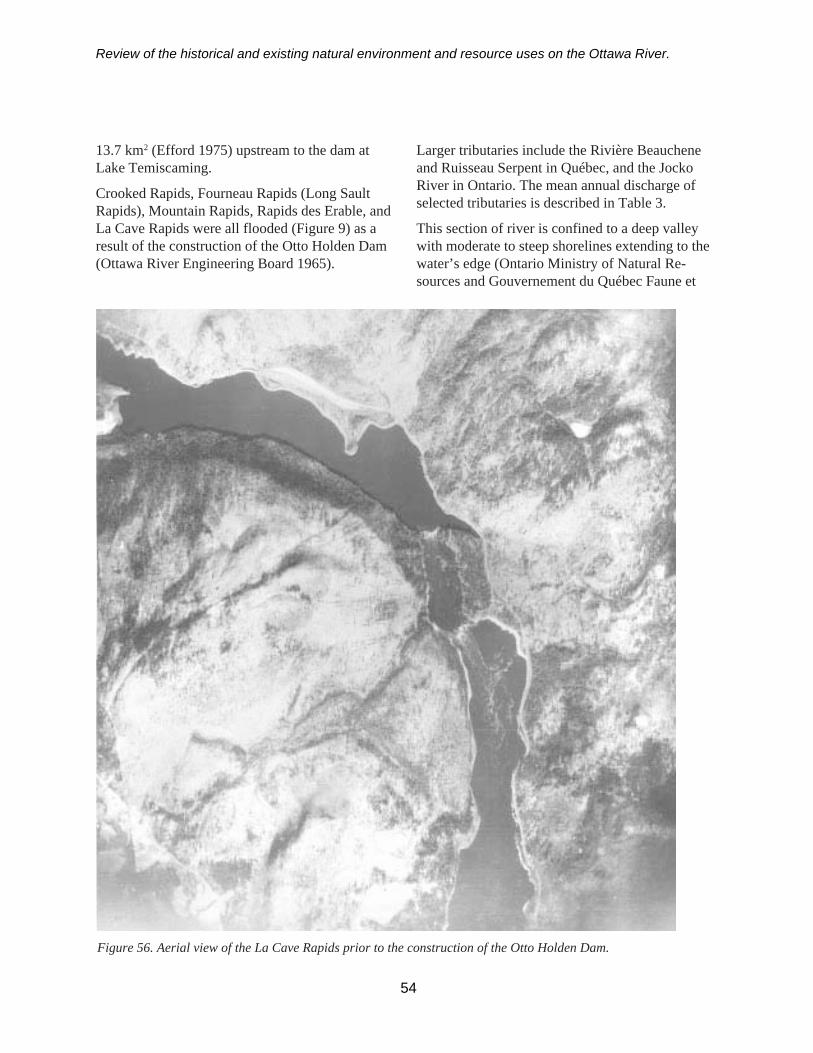
Review of the historical and existing natural environment and resource uses on the Ottawa River.
13.7 km2 (Efford 1975) upstream to the dam atLake Temiscaming.
Crooked Rapids, Fourneau Rapids (Long SaultRapids), Mountain Rapids, Rapids des Erable, andLa Cave Rapids were all flooded (Figure 9) as aresult of the construction of the Otto Holden Dam(Ottawa River Engineering Board 1965).
Larger tributaries include the Rivière Beaucheneand Ruisseau Serpent in Québec, and the JockoRiver in Ontario. The mean annual discharge ofselected tributaries is described in Table 3.
This section of river is confined to a deep valleywith moderate to steep shorelines extending to thewater’s edge (Ontario Ministry of Natural Re-sources and Gouvernement du Québec Faune et
Figure 56. Aerial view of the La Cave Rapids prior to the construction of the Otto Holden Dam.
54

Review of the historical and existing natural environment and resource uses on the Ottawa River.
Parcs 1999). The shorelines are fairly regular withfew islands or shallow bays.
Regulating dams upstream of Lac La Cave wereconstructed between 1911 and 1914 by the govern-ment of Canada: one above Quinze Rapidsupstream of Lake Temiscaming; one at the outletof Lake Temiscaming; and the third on theKippawa River. These dams were built for thepurpose of increasing the volume of flow of theOttawa River at periods of low water (OttawaRiver Engineering Board 1965).
Figure 57. La Cave Rapids, 1948, site of the OttoHolden Dam (Hydro One Archives, Neg. No. 1938).
Figure 59. Aerial view of La Cave rapids during theconstruction of the bypass channel, 1949 (Hydro OneArchives, Neg. No. 374)
Present hydrologyThe mean annual discharge at Otto Holden is 692 m3/s,with a drainage area of 47,900 km2 (Telmer 1996).
Lac la Cave is a reservoir that experiences a winterdrawdown starting in January (Figure 61). Thissection has a storage capacity of 120.8 million m3
of water. There is an annual drawdown of 3.3 mand a maximum drawdown of 4.1 m (Efford 1975).
Time of travel for water from the TemiscamingDam to Otto Holden is about 2–3 hours.
Figure 60. Otto Holden Dam (2000).Figure 58. View of the substrate of La Cave Rapidsduring the construction of the Otto Holden Dam, 1950(Hydro One Archives, Neg, No. E52-291).
55
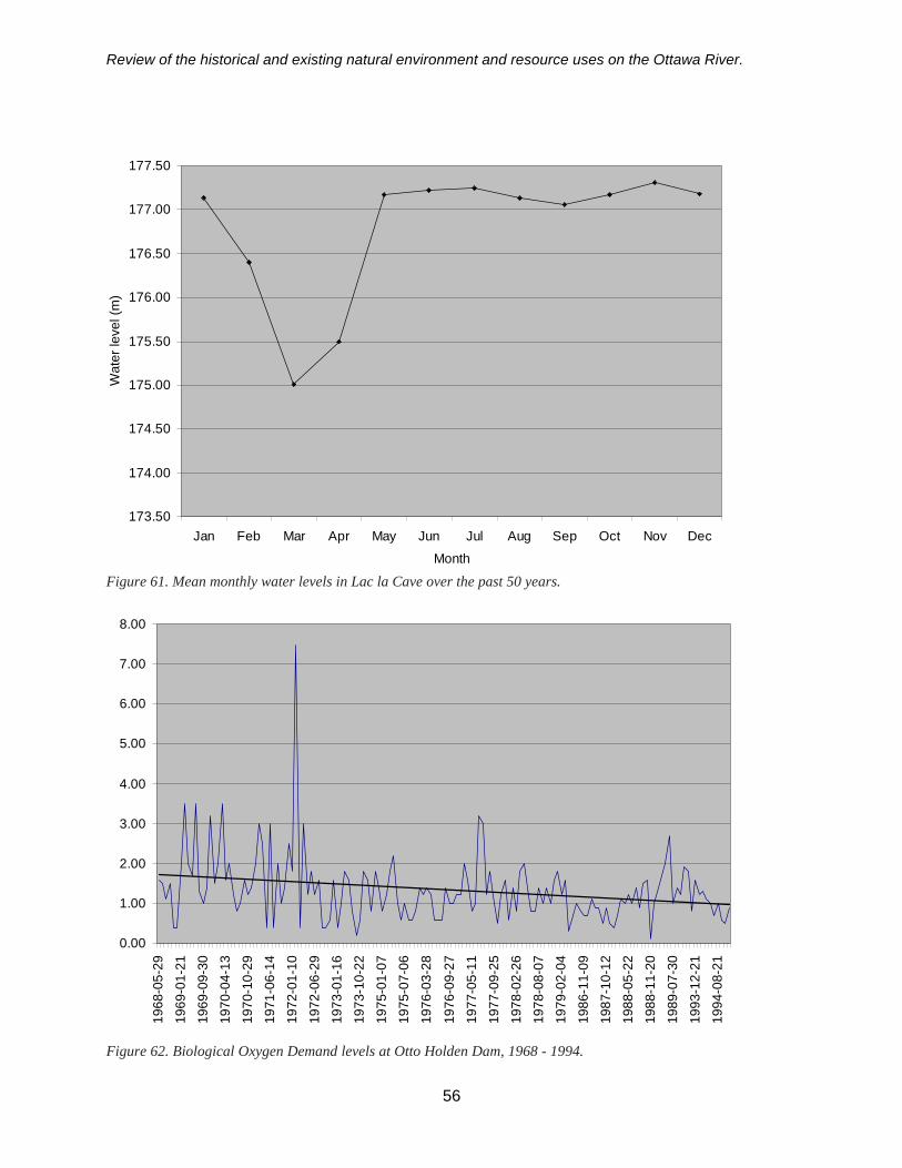
Review of the historical and existing natural environment and resource uses on the Ottawa River.
56
Figure 61. Mean monthly water levels in Lac la Cave over the past 50 years.
Figure 62. Biological Oxygen Demand levels at Otto Holden Dam, 1968 - 1994.
173.50
174.00
174.50
175.00
175.50
176.00
176.50
177.00
177.50
Jan Feb Mar Apr May Jun Jul Aug Sep Oct Nov DecMonth
Wat
er le
vel (
m)
0.00
1.00
2.00
3.00
4.00
5.00
6.00
7.00
8.00
1968
-05-
2919
69-0
1-21
1969
-09-
3019
70-0
4-13
1970
-10-
2919
71-0
6-14
1972
-01-
1019
72-0
6-29
1973
-01-
1619
73-1
0-22
1975
-01-
0719
75-0
7-06
1976
-03-
28
1976
-09-
2719
77-0
5-11
1977
-09-
2519
78-0
2-26
1978
-08-
0719
79-0
2-04
1986
-11-
0919
87-1
0-12
1988
-05-
2219
88-1
1-20
1989
-07-
3019
93-1
2-21
1994
-08-
21

Review of the historical and existing natural environment and resource uses on the Ottawa River.
57
Chemical characteristicsWater quality has been historically influenced bythe pulp and paper mill upstream at Temiscaming(Environment Canada et al. 1985). This reach ofthe river has previously experienced low dissolvedoxygen levels and high ammonia levels (in therange of 0.2 milligrams per litre [mg/l]). In thepast, BOD levels sampled at Otto Holden GS havetended to range between 0.5 and 3.0 mg/l (Figure62) and total phosphorus between 0.02 and 0.05 mg/l(Figure 63). Total Kjeldahl nitrogen levels meas-ured between 1971 and 1984 at Otto Holden haveaveraged around 0.45 mg/l with highs of 2.2 mg/l(Telmer 1996).
Natural environment
FisheriesThis reach supports primarily a coolwater fishery,although warmwater species are present. There are30 species documented within this reach (Appen-dix 1). Walleye, sauger and northern pike are the
Figure 63. Total phosphorous levels at Otto Holden Dam, 1968 - 1994.
predominant game fish although smallmouth bassare also present. Other species includes yellowperch, rock bass, common white suckers, lakeherring, burbot, and the occasional brook trout(Table 4).
Lake sturgeon used to be present in this reach butthe numbers have declined. Pollution from pulpand paper mills caused sturgeon to abandon deepsections in this reach due to oxygen depletion(Harkness and Dymond 1961).
Angling pressure is thought to be very light over-all, with most fishing occurring near Temiscaming(Ontario Ministry of Natural Resources andGouvernement du Québec Faune et Parcs 1999).Walleye, sauger, and perch are the main speciessought.
Walleye spawn downstream of the public dam atLake Temiscaming and in several tributariesthroughout this section.
0.00
0.05
0.10
0.15
0.20
0.2519
68-0
5-29
1969
-06-
01
1970
-04-
13
1971
-02-
25
1971
-10-
12
1972
-06-
29
1973
-03-
13
1974
-10-
23
1975
-07-
06
1976
-05-
24
1977
-01-
03
1977
-09-
25
1978
-04-
09
1978
-12-
03
1979
-07-
30
1980
-06-
22
1981
-04-
19
1981
-12-
07
1982
-09-
29
1983
-08-
07
1984
-06-
14
1985
-05-
06
1986
-09-
14
1987
-09-
13
1988
-06-
19
1989
-02-
26
1990
-02-
25
1994
-07-
24

Review of the historical and existing natural environment and resource uses on the Ottawa River.
58
WildlifeAt least one water bird species, the commonmerganser, and four raptors, bald eagle, sharp-shinned hawk, broad-winged hawk, and red-tailedhawk, have been previously reported to breed inthis reach of the river (Table 5) (Cadman et al.1987). Bald eagles nest within this reach (Belfrypers. comm.7).
Four amphibian and reptile species have beenreported in this reach (Table 6) (Oldham andWeller 2000).
Wetlands, parks, and environmentally sensitiveareasThere are four ANSIs in this reach (Table 9)(OMNR 2001). They include three regionallysignificant ANSIs: Pinetree Point life scienceANSI, Colton Narrows life science ANSI, andJocko/Ottawa River earth science ANSI; and aprovincially significant ANSI: Alexander Lakeforest life science ANSI.
Shoreline developmentThere is very little development along the shorelineof this reach of river.
SummaryThis report has attempted to collate and summarizethe physical changes that occurred in the mainportion of the Ottawa River upstream of Carillon toLake Temicaming, particularly as a result ofhydroelectric development. The more recentdevelopments have been grander in scale, floodingmore land and creating larger reservoirs. There arethree sites in the main part of the river, which areunder 1943 agreement for development by Hydro-Québec on the Ottawa River, that were neverdeveloped: the Rocher Fendu Channel site on thesouth side of Grand-Calumet Island and thePaquette site at Paquette Rapids; and between theRapides des Îles power plant and the head of LakeTemiscaming (Ottawa River Engineering Board1965). Although water flows are regulated, the
white water section of the Chenal du Rocher Fendugives us an example of what the Voyageurs andloggers had to contend with, along the entire lengthof the river. Sections of the river, such as Upperand Lower Allumette and Lac Coulonge, help us tounderstand large river ecosystems under near-natural conditions in comparison to more highlyregulated sections of the river. It may even help usunderstand what the conditions of the river werelike prior to the creation of impoundments with itspotential levels of productivity.
While this report highlighted the changes to theOttawa River, it does not detail the impacts ordescribe the changes that have occurred to eachand every tributary or changes to the landscape.These changes could ultimately affect biota of theOttawa River by blocking migration routes forspawning fish through the construction of a dam,or further altering the natural flow regime. In orderto fully appreciate the changes that have occurredthroughout the Ottawa River, a detailed historicaland current review of conditions in the watershedwould be necessary.
7 Stephen Belfry, OMNR North Bay District, North Bay.

Review of the historical and existing natural environment and resource uses on the Ottawa River.
59
References
Abdelnour, R., S. Robert and J.E. Collings.2000. Preventing ice blockage at hydro plantintakes. Hydro Review. February: 42-53.
Barnett, P.J. 1989. History of the northwesternarm of the Champlain Sea, in Gadd, N.R.,ed. The Late Quaternary Development of theChamplain Sea Basin: Geological Associationof Canada, Special Paper 35, p. 25 - 36.
Biggar, G. 1991. Ontario Hydro’s History andDescription of Hydroelectric GeneratingStations. Ontario Hydro, Toronto, Ontario.334 p.
Bracken, R. and C. Lewis. 2000. Birding in theBritannia Conservation Area and the OttawaRiver. Ontario Field Ornithologists News 18 (2).
Cadman, M.D., P.F.J. Eagles and F.M.Helleiner. 1987. Atlas of the Breeding Birdsof Ontario. Federation of Ontario Naturalistsand Long Point Bird Observatory. Univer-sity of Waterloo. 617p.
Chabot, J. 1992. Effets Environnementaux desCentrakles Otto Holden, Des Joachims,Chenaux et Chats Falls sur la rivière desOutaouais. Ministère du Loisir, de la Chasseet la Pêche letter to B. Hindley, OntarioHydro. December 7 (File No. 97140-146-07270 P).
Chapman, L.J and D.F. Putnam. 1984. ThePhysiography of Southern Ontario. OntarioGeological Survey, Special Volume 2,Ontario Government, Toronto.
Chubbuck, D.A. 1993. Minutes of meetingwith Jim Whyte. Ontario Hydro Hydroelec-tric Rehabilitation Department FilingMemorandum. July 14 (File No. 97140-146-07270 P).
Club des Ornithologues de l’Outaouais. 2000.Sites Ornithologiques de l’Outaouais. http://www.ncf.carleton.ca/coo/
Corporation Passe des Rapides. 1993. TourismDevelopment on the Island of Rapides desJoachims. Potential Site Considerations.Submission to Ontario Hydro, Hydro-Quebec and the Ministry of Energy andResources.
Critchlow, D.P. 2000. Summary of 1999commercial fishing on the Ottawa River.Ontario Ministry of Natural Resources,Kemptville District. 7 p.
Daigle, C, A. Desrosiers and J. Bonin. 1994.Distribution and abundance of common mapturtles in the Ottawa River, Québec. Can.Field Naturalist 108:84-86.
Denis, L.G. and A. White. 1911. Water Powerof Canada. Commission of ConservationCanada. The Mortimer Co. Ltd., Ottawa.397 p.
Department of Lands and Forests. 1964. Ahistory of Kemptville Forest District. De-partment of lands and Forests, DistrictHistory Series, No. 17.
Easton, R. 1968. Sturgeon study – OttawaRiver. Ontario Department of Lands andForests, Kemptville District. 32 p.
Efford, I.E. 1975. Assessment on the impact ofhydro dams. J. Fish. Res. Board Can. 32:196-206.
Ells, R.W. 1901. Ancient channels of theOttawa River. Ottawa Naturalist 15:17-30.
Envirocon Ltd/Proctor & Redfern Ltd. 1979.Chats Falls GS B Nuclear Site BaselineEnvironmental Studies. 1978-1979. Vol. 1.Consultants Report to Ontario Hydro Envi-ronmental Studies and Assessments Department.

Review of the historical and existing natural environment and resource uses on the Ottawa River.
Environment Canada, Environment Ontarioand Environment Québec. 1985. WaterQuality in the Ottawa River. Annual reportof the Coordinating Committee for WaterQuality in the Ottawa River to the Govern-ments of Canada, Québec and Ontario.Minister of Supply and Services, Canada. 42 p.
Finlay, J.C. 2000. A Bird-Finding Guide toCanada. (Revision of 1984 Publication).Aspen House Productions. 449 p.
Fourier, P. 1979. Historical Concept Plan:Fitzroy Provincial Park. Part 2. HistoricalResource Evaluation. Ontario Ministry ofNatural Resources.
Gaffield, C. 1997. History of the Outaouais.Institut québécois de recherche sur la cul-ture. Les Presses de l’Université Laval. 843 p.
Goodwin, C.E. 1995. A bird-finding guide toOntario. University of Toronto Press. 477p.
Gourlay, J.L. 1896. History of the OttawaValley. Department of Agriculture, Canada.288 p.
Hargreaves, J. 1998. Ottawa RiverWhitewater: a Paddler’s Guide to the Mid-dle and Main Channel. Cascade Press,Canada. 200 p.
Harkness. W.J.K. and J.R. Dymond. 1961. TheLake Sturgeon: the History of Its Fisheryand Problems of Conservation. OntarioDepartment of Lands and Forests, Fish andWildlife Branch. Toronto, Ontario. 121 p.
Haxton, T. 1997. A review of the early seasonwalleye harvest from the Ottawa River.Ontario Ministry of Natural Resources,Pembroke District, Pembroke. 16 p.
Haxton, T. 1998. Nearshore community indexnetting of Lac du Rocher Fendu (OttawaRiver) in the late summer of 1997. OntarioMinistry of Natural Resources, PembrokeDistrict, Pembroke. 14 p.
Haxton, T. 1999. Nearshore community indexnetting of Lac des Chats (Ottawa River).Ontario Ministry of Natural Resources,Pembroke District, Pembroke. 19 p.
Haxton, T. 2000a. Nearshore community indexnetting of Lac Coulonge (Ottawa River) inthe late summer of 1999. Ontario Ministryof Natural Resources, Pembroke District,Pembroke. 13 p.
Haxton, T. 2000b. Nearshore communityindex netting of Lower Allumette (OttawaRiver) in the late summer of 1999. OntarioMinistry of Natural Resources, PembrokeDistrict, Pembroke. 13 p.
Haxton, T. in review. Status and characteristicsof lake sturgeon (Acipenser fulvescens) inthe Ottawa River.
Hincks, J. 1978. River Basin Development:Perspectives on the Ottawa River. MAThesis. University of Ottawa, Ottawa,Ontario. 216 p.
Hughson, J.W. and C. Bond. 1964. HurlingDown the Pine. The Historical Society ofthe Gatineau, Chelsea, Quebec. 130 p.
Hydro-Electric Power Commission of Ontario.1950a. Chenaux Power Development,Ottawa River. Ontario 7 p.
Hydro-Electric Power Commission of Ontario.1950b. Des Joachims Generating Station,Ottawa River. Ontario. 11 p.
Hydro-Electric Power Commission of Ontario.1950c. La Cave Power Development, Ot-tawa River. Ontario.
60

Review of the historical and existing natural environment and resource uses on the Ottawa River.
Hydro-Québec. 1996. Carillon Power Station.Hydro-Quebec, Région MaissonneuveÉquipe Communication. 4 p.
Jolicoeur, G. 1992. Presence D’especesMenacees Entre les CentralesHydrolectriques Ontariennes. Ministere del’Environnement letter to C. Gosselin,Ontario Hydro. November 30 (File No.97140-146-07270 P).
Kennedy, C.C. 1970. The Upper OttawaValley. Renfrew County Council,Pembroke, Ontario. 256 p.
Lafrenière, N. 1984. The Ottawa River CanalSystem. Parks Canada, Hull, QC. 95 p.
Lambart, H. and G. Rigby. 1963. SubmergedHistory of the Long Sault. Canadian Geo-graphical Journal 67: 147-157.
Legget, R. 1975. Ottawa Waterway: Gatewayto a Continent. University of Toronto Press,Toronto and Buffalo. 291 p.
Mackie, G.L. and S.U. Quadri. 1973. Abun-dance and diversity of Mollusca in an indus-trialized portion of the Ottawa River nearOttawa-Hull, Canada. J. Fish. Res. BoardCan. 30: 167-172.
McAllister, D.E. and B. W. Coad. 1974. Fishesof Canada’s National Capital Region. Na-tional Museum of Natural Sciences, Miscel-laneous Special Publication 24, Ottawa. 200 p.
McKeating, G. 1990. Birds of Ottawa andvicinity. Lone Pine Publishing. 144 p.
Merriman, J.C. 1987. Bottom Sediment Qual-ity of the Ottawa River. Technical BulletinNo. 153. Environment Canada. Burlington,Ontario.
Michener, C. 1996. Bird records of thePembroke & Area Bird Club, Pembroke,ON.
Mika, N., and H. Mika. 1982. Bytown. TheEarly Days of Ottawa. Mika PublishingCompany, Belleville, ON. 257 p.
Munro, W.T. 1967. Changes in WaterfowlHabitat with Flooding on the Ottawa River.J. Wild. Mgmt 31: 197-199.
Niblett Environmental Associates Inc. 1990.Chats Falls GS Sluice Gate Study. Consult-ants Report to W. Weller, Ontario HydroSafety and Environmental Department.August 13 (File No. EAA 12.31.1).
Oldham, M.J. and W.F. Weller. 2000. OntarioHerpetofaunal Atlas. Natural HeritageInformation Centre. Ontario Ministry ofnatural Resources, Peterborough.
Ontario Hydro. 1984a. Procedures and Stand-ards for Operating Des Joachims-HydraulicSheet No. 511-2. Technical Directive No.HO 994 R1 (March).
Ontario Hydro. 1984b. Operating HydraulicData-Otto Holden GS River No. 51-1.Technical Directive No. HO 963 R1 (May).
Ontario Hydro. 1984c. Operation of the DesJoachims GS Forebay during Freshet.Technical Directive No. HO 1008 (Novem-ber).
Ontario Hydro. 1988. Low Water Operation-Ottawa River. Technical Directive No. HO927-R2 (October).
Ontario Hydro. 1989a. Operating HydraulicData-Chenaux Gs-River Number 51-3.Technical Directive No. HO 964-R1(March).
61

Review of the historical and existing natural environment and resource uses on the Ottawa River.
Ontario Hydro. 1992a. Hydroelectric genera-tion planning in the Ottawa River drainagebasin. A discussion paper.
Ontario Ministry of Natural Resources. 1985.Ontario Water Power Sites. Queen’s Printer,Toronto.
Ontario Ministry of Natural Resources. 2000.File data. Pembroke District, Pembroke.
Ontario Ministry of Natural Resources. 2001a.Natural Heritage Information Centre Data-base. Peterborough.
Ontario Ministry of Natural Resources. 2001b.File data. Pembroke District, Pembroke.
Ontario Ministry of Natural Resources andGouvernement du Québec Faune et Parcs.1999. A Strategic Fisheries ManagementFramework for the Ottawa River. OntarioMinistry of Natural Resources, Pembroke,Canada. 72 p.
Ontario Water Resources Commission andQuebec Water Board. 1971. Ottawa RiverBasin: Water Quality and Its Control in theOttawa River. Vol. 1.
Ontario Water Resources Commission andQuebec Water Board. 1972. Ottawa RiverBasin: Water Quality and Its Control in theOttawa River. Vol. 2.
Ottawa River Engineering Board. 1965. Reporton Hydrology and Regulation of The Ot-tawa River. Ottawa River EngineeringBoard.
Ottawa River Regulation Planning Board.1984. Managing the Water of the OttawaRiver. Hull, QC. 11 p.
Ottawa River Regulation Planning Board.1987. Ottawa River Basin. Map.
Pawson, H.E. 1927. The Bryson HydroelectricPower Development. The EngineeringJournal. October. 459-467.
Pilon, J. 1999. Ottawa Valley Prehistory.Outaouais Historical Society, Hull. 113 p.
Regional Municipality of Ottawa-Carleton.1992. Surface Water Quality Programme –Ottawa River Summary Report. Environ-mental Services Department
Regional Municipality of Ottawa-Carleton(RMOC) 1999. Trends in water qualityparameters pertinent to fish and contaminantlevels in fish in the Rideau and OttawaRivers. Prepared by the Surface WaterQuality Branch, Environment and Transpor-tation Department, Regiuon of Ottawa-Carleton.
Rowe, R.S. 1972. Forest Regions of Canada.Canadian Forestry Service Publication No.1300. Information Canada.
Sankey, J. 1987. Enjoying the Birds of theOttawa Valley. The Runge Press Limited.Ottawa. 116 p.
Sherriff, A. 1831. Topographic notices of thecountry lying between the mouth of theRideau and Penetanguishene on LakeHuron. Transactions of the Literacy andHistorical Society of Quebec, Vol. II. pages243-309.
Statistics Canada. 2001. 1996 Population byCommunity. (http://ceps.statcan.ca)
Societie du la Faune et la Parcs. 2001. HullQC. File data.
Telmer, K.H. 1996. Biogeochemistry andWater Balance of the Ottawa River Basin.Ph.D. Thesis. University of Ottawa, Ottawa,Canada. 239 p.
62

Review of the historical and existing natural environment and resource uses on the Ottawa River.
63
Tremblay, Heroux and Associates, ConsultingEngineers. 1970. Inventory of the CrownHoldings on the Ottawa River. Departmentof Public Works of Canada.

Review of the historical and existing natural environment and resource uses on the Ottawa River.
hcaeR emaNnommoC emaNcifitneicS detnemucoDraeYtsaL
evaCalcaL
renihsesontnulb sutatonselahpemiP )2991namssorCdnakardnaM(
kcabelkcitskoorb snatsnocniaeluC )2991namssorCdnakardnaM(
tuortkoorb silanitnofsunilevlaS )b9991NIWF(9991
tobrub atolatoL )b9991NIWF(9991
renihsnommoc sutunrocsiportoN )b9991NIWF(9991
buhckeerc sutalucamortasulitomeS )2991namssorCdnakardnaM(
renihsdlareme sedionirehtasiportoN )2991namssorCdnakardnaM(
hsifllaf silaroprocsulitomeS )b9991NIWF(9991
wonnimdaehtaf salemorpselahpemiP )2991namssorCdnakardnaM(
ecadelacsenif sueagoensunixohP )2991namssorCdnakardnaM(
murdretawhserf sneinnurgsutonidolpA )2991namssorCdnakardnaM(
renihsnedlog sacuelosyrcsunogimetoN )2991namssorCdnakardnaM(
retradynnhoj murginamotsoehtE )2991namssorCdnakardnaM(
buhcekal suebmulpsuiseuoC )2991namssorCdnakardnaM(
hsifetihwekal simrofaepulcsunogeroC )b9991NIWF(9991
hcrepgol sedorpacanicreP )2991namssorCdnakardnaM(
ragesongnol suessosuetsosipeL )2991namssorCdnakardnaM(
rekcusesongnol sumotsotacsumotsotaC )b9991NIWF(9991
eyenoom susigretnodoiH )2991namssorCdnakardnaM(
ekipnrehtron suiculxosE )b9991NIWF(9991
ecadyllebdernrehtron soesunixohP )2991namssorCdnakardnaM(
ecadlraep atiragramsulitomeS )2991namssorCdnakardnaM(
ssabkcor sirtsepursetilpolbmA )b9991NIWF(9991
reguas esnedanacnoidetsozitS )b9991NIWF(9991
niplucsymils sutangocsuttoC )2991namssorCdnakardnaM(
ssabhtuomllams iueimolodsuretporciM )b9991NIWF(9991
renihsliattops suinosduhsiportoN )b9991NIWF(9991
eyellaw muertivnidetsozitS )b9991NIWF(9991
rekcusetihw inosremmocsumotsotaC )b9991NIWF(9991
hcrepwolley snecsevalfacreP )b9991NIWF(9991
Appendix 1. Fish species in the various reaches of the Ottawa River.
64

Review of the historical and existing natural environment and resource uses on the Ottawa River.
hcaeR emaNnommoC emaNcifitneicS detnemucoDraeYtsaL
ekaLnedloH
renihsnihckcalb nodoretehsiportoN )2991namssorCdnakardnaM(
renihsesonkcalb sipeloretehsiportoN )6991nessumsaRdnanawoR(
lligeulb surihcorcamsimopeL )2991namssorCdnakardnaM(
renihsesontnulb sutatonselahpemiP )2991namssorCdnakardnaM(
kcabelkcitskoorb snatsnocniaeluC )2991namssorCdnakardnaM(
daehllubnworb susolubensurulatcI )8991RNMO(8991
tobrub atolatoL )8991RNMO(8991
renihsnommoc sutunrocsiportoN )8991RNMO(8991
buhckeerc sutalucamortasulitomeS )8991RNMO(8991
renihsdlareme sedionirehtasiportoN )6991nessumsaRdnanawoR(
hsifllaf silaroprocsulitomeS )2991namssorCdnakardnaM(
wonnimdaehtaf salemorpselahpemiP )2991namssorCdnakardnaM(
ecadelacsenif sueagoensunixohP )2991namssorCdnakardnaM(
eyedlog sediosolanodoiH )8991RNMO(8991
retradawoI elixeamotsoehtE )2991namssorCdnakardnaM(
retradynnhoj murginamotsoehtE )6991nessumsaRdnanawoR(
buhcekal suebmulpsuiseuoC )2991namssorCdnakardnaM(
gnirrehekal iidetrasunogeroC )1891tluaengiM(0891
hsifetihwekal simrofaepulcsunogeroC )8991RNMO(8991
hcrepgol sedorpacanicreP )6991nessumsaRdnanawoR(
ecadesongnol eatcaratacsyhthcinihR )2991namssorCdnakardnaM(
rekcusesongnol sumotsotacsumotsotaC )8991RNMO(8991
renihscimim sulleculovsoprtoN )2991namssorCdnakardnaM(
ekipnrehtron suiculxosE 8991RNMO(8991
ecadyllebdernrehtron soesunixohP )2991namssorCdnakardnaM(
ecadlraep atiragramsulitomeS )2991namssorCdnakardnaM(
ssabkcor sirtsepursetilpolbmA )8991RNMO(8991
renihsecafysor sullebursiportoN )2991namssorCdnakardnaM(
reguas esnedanacnoidetsozitS )8991RNMO(8991
esrohderdaehtrohs mutodipelorcamamotsoxoM )8991RNMO(8991
65
Appendix 1. Fish species in the various reaches of the Ottawa River—continued.

Review of the historical and existing natural environment and resource uses on the Ottawa River.
hcaeR emaNnommoC emaNcifitneicS detnemucoDraeYtsaL
).tnoc(ekaLnedloH
esrohderrevlis murusinaamotsoxoM )8991RNMO(8991
ssabhtuomllams iueimolodsuretporciM )8991RNMO(8991
renihsliattops suinosduhsiportoN )6991nessumsaRdnanawoR(
eyellaw muertivnidetsozitS )8991RNMO(8991
rekcusetihw inosremmocsumotsotaC )8991RNMO(8991
hcrepwolley snecsevalfacreP )8991RNMO(8991
ekaLettemullA
leenaciremA atartsoralliugnA )6991noraCdnatobahC(
hsifillikdednab sunahpaidsuludnuF )6991noraCdnatobahC(
renihsnihckcalb nodoretehsiportoN )a6991notsuoH(
renihsesonkcalb sipeloretehsiportoN )2991namssorCdnakardnaM(
renihsesontnulb sutatonselahpemiP )2991namssorCdnakardnaM(
wonnimyssarb inosniknahsuhtangobyH )2991namssorCdnakardnaM(
kcabelkcitskoorb snatsnocniaeluC )2991namssorCdnakardnaM(
tobrub atolatoL )0002FPS(0002
hsiftaclennahc sutatcnupsurulatcI )c1002RNMO(1002
pracnommoc oipracsunirpyC )6991noraCdnatobahC(
buhckeerc sutalucamortasulitomeS )2991namssorCdnakardnaM(
renihsdlareme sedionirehtasiportoN )6991noraCdnatobahC(
hsifllaf silaroprocsulitomeS )0002FPS(0002
wonnimdaehtaf salemorpselahpemiP )2991namssorCdnakardnaM(
ecadelacsenif sueagoensunixohP )2991namssorCdnakardnaM(
murdretawhserf sneinnurgsutonidolpA )2991namssorCdnakardnaM(
renihsnedlog sacuelosyrcsunogimetoN )2991namssorCdnakardnaM(
retradawoI elixeamotsoehtE )2991namssorCdnakardnaM(
retradynnhoj murginamotsoehtE )2991namssorCdnakardnaM(
gnirrehekal iidetrasunogeroC )0002FPS(0002
noegrutsekal snecsevlufresnepicA )c1002RNMO(1002
tuortekal hsucyamansunilevlaS )6991noraCdnatobahC(
hsifetihwekal simrofaepulcsunogeroC )0002FPS(0002
66
Appendix 1. Fish species in the various reaches of the Ottawa River—continued.

Review of the historical and existing natural environment and resource uses on the Ottawa River.
hcaeR emaNnommoC emaNcifitneicS detnemucoDraeYtsaL
ekaLettemullA
ssabhtuomegral sediomlassuretporciM )c1002RNMO(1002
hcrepgol sedorpacanicreP )2991namssorCdnakardnaM(
ecadesongnol eatcaratacsyhthcinihR )2991namssorCdnakardnaM(
ragesongnol suessosuetsosipeL )c1002RNMO(1002
rekcusesongnol sumotsotacsumotsotaC )b8991notxaH(5991
renihscimim sulleculovsoprtoN )2991namssorCdnakardnaM(
eyenoom susigretnodoiH )c1002RNMO(1002
niplucsdelttom idriabsuttoC )2991namssorCdnakardnaM(
egnulleksum ygnoniuqsamxosE )c1002RNMO(1002
kcabelkcitsenipsenin suitignupsuitignuP )6991noraCdnatobahC(
ekipnrehtron suiculxosE )c1002RNMO(1002
ecadyllebdernrehtron soesunixohP )2991namssorCdnakardnaM(
ecadlraep atiragramsulitomeS )2991namssorCdnakardnaM(
deesnikpmup susobbigsimopeL )c1002RNMO(1002
tlemswobniar xadromsuremsO )6991noraCdnatobahC(
tuortwobniar irendriagomlaS )b8991notxaH(5991
esrohderrevir mutaniracamotsoxoM )0002FPS(0002
ssabkcor sirtsepursetilpolbmA )c1002RNMO(1002
renihsecafysor sullebursiportoN )b6991notsuoH(
renihsdnas suenimartssiportoN )2991namssorCdnakardnaM(
reguas esnedanacnoidetsozitS )c1002RNMO(1002
esrohderdaehtrohs mutodipelorcamamotsoxoM )c1002RNMO(1002
yerpmalrevlis sipsucinunozymyhtcI )6991noraCdnatobahC(
esrohderrevlis murusinaamotsoxoM )c1002RNMO(1002
niplucsymils sutangocsuttoC )2991namssorCdnakardnaM(
ssabhtuomllams iueimolodsuretporciM )c1002RNMO(1002
renihsliattops suinosduhsiportoN )b8991notxaH(5991
retraddetallesset idetsmloamotsoehtE )2991namssorCdnakardnaM(
kcabelkcitsenipseerht sutaelucasuetsoretsaG )1891tluaengiM(0891
eyellaw muertivnidetsozitS )c1002RNMO(1002
67
Appendix 1. Fish species in the various reaches of the Ottawa River—continued.

Review of the historical and existing natural environment and resource uses on the Ottawa River.
hcaeR emaNnommoC emaNcifitneicS detnemucoDraeYtsaL
ekaLettemullA
rekcusetihw inosremmocsumotsotaC )c1002RNMO(1002
daehllubwolley silatansurulatcI )c1002RNMO(1002
hcrepwolley snecsevalfacreP )0002FPS(0002
ettemullArewoLekaL
eipparckcalb sutalucamorginsixomoP )b0002notxaH(9991
renihsnihckcalb nodoretehsiportoN )b6991notsuoH(
renihsesontnulb sutatonselahpemiP )2991namssorCdnakardnaM(
daehllubnworb susolubensurulatcI )b0002notxaH(9991
hsiftaclennahc sutatcnupsurulatcI )b0002notxaH(9991
renihsdlareme sedionirehtasiportoN )b1002RNMO(1002
hsifllaf silaroprocsulitomeS )2991namssorCdnakardnaM(
renihsnedlog sacuelosyrcsunogimetoN )2991namssorCdnakardnaM(
retradynnhoj murginamotsoehtE )2991namssorCdnakardnaM(
noegrutsekal snecsevlufresnepicA )b0002notxaH(9991
ssabhtuomegral sediomlassuretporciM )b0002notxaH(9991
hcrepgol sedorpacanicreP )2991namssorCdnakardnaM(
ragesongnol suessosuetsosipeL )b0002notxaH(9991
eyenoom susigretnodoiH )b0002notxaH(9991
ekipnrehtron suiculxosE )b1002RNMO(1002
deesnikpmup susobbigsimopeL )b1002RNMO(1002
esrohderrevir mutaniracamotsoxoM )b0002notxaH(9991
ssabkcor sirtsepursetilpolbmA )b0002notxaH(9991
renihsecafysor sullebursiportoN )b6991notsuoH(
reguas esnedanacnoidetsozitS )b0002notxaH(9991
esrohderdaehtrohs mutodipelorcamamotsoxoM )b0002notxaH(9991
esrohderrevlis murusinaamotsoxoM )b0002notxaH(9991
ssabhtuomllams iueimolodsuretporciM )b0002notxaH(9991
renihsliattops suinosduhsiportoN )b1002RNMO(1002
eyellaw muertivnidetsozitS )b0002notxaH(9991
rekcusetihw inosremmocsumotsotaC )b0002notxaH(9991
68
Appendix 1. Fish species in the various reaches of the Ottawa River—continued.

Review of the historical and existing natural environment and resource uses on the Ottawa River.
hcaeR emaNnommoC emaNcifitneicS detnemucoDraeYtsaL
ettemullArewoLekaL
daehllubwolley silatansurulatcI )b1002RNMO(1002
hcrepwolley snecsevalfacreP )b1002RNMO(1002
egnoluoCcaL
renihsnihckcalb nodoretehsiportoN )b6991notsuoH(
renihsesontnulb sutatonselahpemiP )2991namssorCdnakardnaM(
daehllubnworb susolubensurulatcI )a0002notxaH(9991
tobrub atolatoL )a0002notxaH(9991
wonnimdumlartnec imilarbmU )6991noraCdnatobahC(
hsiftaclennahc sutatcnupsurulatcI )a0002notxaH(9991
renihsdlareme sedionirehtasiportoN )2991namssorCdnakardnaM(
hsifllaf silaroprocsulitomeS )2991namssorCdnakardnaM(
wonnimdaehtaf salemorpselahpemiP )2991namssorCdnakardnaM(
renihsnedlog sacuelosyrcsunogimetoN )2991namssorCdnakardnaM(
retradynnhoj murginamotsoehtE )2991namssorCdnakardnaM(
gnirrehekal iidetrasunogeroC )b8991notxaH(0791
noegrutsekal snecsevlufresnepicA )a0002notxaH(9991
hsifetihwekal simrofaepulcsunogeroC )b8991notxaH(0791
ssabhtuomegral sediomlassuretporciM )a0002notxaH(9991
hcrepgol sedorpacanicreP )2991namssorCdnakardnaM(
ragesongnol suessosuetsosipeL )a0002notxaH(9991
eyenoom susigretnodoiH )a0002notxaH(9991
ekipnrehtron suiculxosE )a0002notxaH(9991
ecadlraep atiragramsulitomeS )6991noraCdnatobahC(
deesnikpmup susobbigsimopeL )a0002notxaH(9991
esrohderrevir mutaniracamotsoxoM )a0002notxaH(9991
ssabkcor sirtsepursetilpolbmA )a0002notxaH(9991
renihsecafysor sullebursiportoN )b6991notsuoH(
reguas esnedanacnoidetsozitS )a0002notxaH(9991
esrohderdaehtrohs mutodipelorcamamotsoxoM )a0002notxaH(9991
esrohderrevlis murusinaamotsoxoM )a0002notxaH(9991
69
Appendix 1. Fish species in the various reaches of the Ottawa River—continued.

Review of the historical and existing natural environment and resource uses on the Ottawa River.
hcaeR emaNnommoC emaNcifitneicS detnemucoDraeYtsaL
egnoluoCcaL
niplucsymils sutangocsuttoC )6991noraCdnatobahC(
ssabhtuomllams iueimolodsuretporciM )a0002notxaH(9991
eyellaw muertivnidetsozitS )a0002notxaH(9991
rekcusetihw inosremmocsumotsotaC )a0002notxaH(9991
daehllubwolley silatansurulatcI )1891tluaegiM(0891
hcrepwolley snecsevalfacreP )a0002notxaH(9991
rehcoRudcaLudneF
renihsnihckcalb nodoretehsiportoN )b6991notsuoH(
kcabelkcitskoorb snatsnocniaeluC )2991namssorCdnakardnaM(
daehllubnworb susolubensurulatcI )a0002RNMO(0002
tobrub atolatoL )1891tluaegiM(0891
hsiftaclennahc sutatcnupsurulatcI )a0002RNMO(0002
renihsdlareme sedionirehtasiportoN )2991namssorCdnakardnaM(
murdretawhserf sneinnurgsutonidolpA )a0002RNMO(0002
retradynnhoj murginamotsoehtE )2991namssorCdnakardnaM(
noegrutsekal snecsevlufresnepicA )a0002RNMO(0002
ssabhtuomegral sediomlassuretporciM )a0002RNMO(0002
ragesongnol suessosuetsosipeL )a0002RNMO(0002
eyenoom susigretnodoiH )8991notxaH(7991
ekipnrehtron suiculxosE )a0002RNMO(0002
deesnikpmup susobbigsimopeL )a0002RNMO(0002
esrohderrevir mutaniracamotsoxoM )8991notxaH(7991
ssabkcor sirtsepursetilpolbmA )a0002RNMO(0002
renihsecafysor sullebursiportoN )b6991notsuoH(
reguas esnedanacnoidetsozitS )a0002RNMO(0002
esrohderdaehtrohs mutodipelorcamamotsoxoM )a0002RNMO(0002
esrohderrevlis murusinaamotsoxoM )a0002RNMO(0002
ssabhtuomllams iueimolodsuretporciM )a0002RNMO(0002
eyellaw muertivnidetsozitS )a0002RNMO(0002
rekcusetihw inosremmocsumotsotaC )a0002RNMO(0002
70
Appendix 1. Fish species in the various reaches of the Ottawa River—continued.

Review of the historical and existing natural environment and resource uses on the Ottawa River.
hcaeR emaNnommoC emaNcifitneicS detnemucoDraeYtsaL
rehcoRudcaLudneF
daehllubwolley silatansurulatcI )1891tluaegiM(0891
hcrepwolley snecsevalfacreP )a0002RNMO(0002
stahCsedcaL
leenaciremA atartsoralliugnA )9991notxaH(8991
hsifillikdednab sunahpaidsuludnuF )b8991notxaH(0991
eipparckcalb sutalucamorginsixomoP )9991notxaH(8991
renihsnihckcalb nodoretehsiportoN )7791drofnuD(7791
renihsesonkcalb sipeloretehsiportoN )7791drofnuD(7791
lligeulb surihcorcamsimopeL )2991namssorCdnakardnaM(
renihsesontnulb sutatonselahpemiP )b8991notxaH(0991
daehllubnworb susolubensurulatcI )9991notxaH(8991
tobrub atolatoL )b8991notxaH(7991
hsiftaclennahc sutatcnupsurulatcI )9991notxaH(8991
pracnommoc oipracsunirpyC )6991noraCdnatobahC(
buhckeerc sutalucamortasulitomeS )2991namssorCdnakardnaM(
renihsdlareme sedionirehtasiportoN )b8991notxaH(0991
hsifllaf silaroprocsulitomeS )2991namssorCdnakardnaM(
renihsnedlog sacuelosyrcsunogimetoN )b8991notxaH(6891
eyedlog sediosolanodoiH )b8991notxaH(1691
esrohderretaerg isenneicnelavamotsoxoM )9991notxaH(8991
retradawoI elixeamotsoehtE )7791drofnuD(7791
retradynnhoj murginamotsoehtE )b8991notxaH(0991
noegrutsekal snecsevlufresnepicA )9991notxaH(8991
hsifetihwekal simrofaepulcsunogeroC )b8991notxaH(1691
ssabhtuomegral sediomlassuretporciM )9991notxaH(8991
hcrepgol sedorpacanicreP )b8991notxaH(0991
ragesongnol suessosuetsosipeL )9991notxaH(8991
rekcusesongnol sumotsotacsumotsotaC )6991noraCdnatobahC(
renihscimim sulleculovsoprtoN )7791drofnuD(7791
eyenoom susigretnodoiH )b8991notxaH(7991
71
Appendix 1. Fish species in the various reaches of the Ottawa River—continued.

Review of the historical and existing natural environment and resource uses on the Ottawa River.
hcaeR emaNnommoC emaNcifitneicS detnemucoDraeYtsaL
stahCsedcaL
egnulleksum ygnoniuqsamxosE )9991notxaH(8991
ekipnrehtron suiculxosE )9991notxaH(8991
deesnikpmup susobbigsimopeL )b8991notxaH(7991
esrohderrevir mutaniracamotsoxoM )9991notxaH(8991
ssabkcor sirtsepursetilpolbmA )9991notxaH(8991
renihsecafysor sullebursiportoN )2991namssorCdnakardnaM(
reguas esnedanacnoidetsozitS )b8991notxaH(7991
esrohderdaehtrohs mutodipelorcamamotsoxoM )b8991notxaH(7991
esrohderrevlis murusinaamotsoxoM )9991notxaH(8991
ssabhtuomllams iueimolodsuretporciM )9991notxaH(8991
renihsliattops suinosduhsiportoN )b8991notxaH(0991
eyellaw muertivnidetsozitS )9991notxaH(8991
rekcusetihw inosremmocsumotsotaC )9991notxaH(8991
daehllubwolley silatansurulatcI )9991notxaH(8991
hcrepwolley snecsevalfacreP )b8991notxaH(7991
senehcseDcaL
leenaciremA atartsoralliugnA )9891RNMO(9891
hsifillikdednab sunahpaidsuludnuF )2991namssorCdnakardnaM(
daehllubkcalb salemsurulatcI )2991namssorCdnakardnaM(
eipparckcalb sutalucamorginsixomoP )b0002RNMO(0002
renihsnihckcalb nodoretehsiportoN )2991namssorCdnakardnaM(
renihsesonkcalb sipeloretehsiportoN )2991namssorCdnakardnaM(
lligeulb surihcorcamsimopeL )9891RNMO(9891
renihsesontnulb sutatonselahpemiP )2991namssorCdnakardnaM(
kcabelkcitskoorb snatsnocniaeluC )2991namssorCdnakardnaM(
daehllubnworb susolubensurulatcI )b0002RNMO(0002
tuortnworb atturtomlaS )6991noraCdnatobahC(
tobrub atolatoL )b1991RNMO(1991
wonnimdumlartnec imilarbmU )6991noraCdnatobahC(
hsiftaclennahc sutatcnupsurulatcI )b0002RNMO(0002
72
Appendix 1. Fish species in the various reaches of the Ottawa River—continued.

Review of the historical and existing natural environment and resource uses on the Ottawa River.
hcaeR emaNnommoC emaNcifitneicS detnemucoDraeYtsaL
senehcseDcaL
retradlennahc idnalepocanicreP )4991dlihcdooG(
pracnommoc oipracsunirpyC )b0002RNMO(0002
renihsnommoc sutunrocsiportoN )6991noraCdnatobahC(
buhckeerc sutalucamortasulitomeS )2991namssorCdnakardnaM(
wonnimyrevlisnretsae suigersuhtangobyH )6991noraCdnatobahC(
renihsdlareme sedionirehtasiportoN )2991namssorCdnakardnaM(
hsifllaf silaroprocsulitomeS )2991namssorCdnakardnaM(
wonnimdaehtaf salemorpselahpemiP )2991namssorCdnakardnaM(
renihsnedlog sacuelosyrcsunogimetoN )2991namssorCdnakardnaM(
retradawoI elixeamotsoehtE )2991namssorCdnakardnaM(
retradynnhoj murginamotsoehtE )2791.lateretsillAcM(
gnirrehekal iidetrasunogeroC )6991noraCdnatobahC(
noegrutsekal snecsevlufresnepicA )b1991RNMO(1991
ssabhtuomegral sediomlassuretporciM )b0002RNMO(0002
hcrepgol sedorpacanicreP )a1002RNMO(1002
ecadesongnol eatcaratacsyhthcinihR )2991namssorCdnakardnaM(
ragesongnol suessosuetsosipeL )b0002RNMO(0002
rekcusesongnol sumotsotacsumotsotaC )b1991RNMO(1991
renihscimim sulleculovsoprtoN )2991namssorCdnakardnaM(
eyenoom susigretnodoiH )b1991RNMO(1991
niplucsdelttom idriabsuttoC )2991namssorCdnakardnaM(
egnulleksum ygnoniuqsamxosE )0991ttelbiN(0991
kcabelkcitsenipsenin suitignupsuitignuP )6991noraCdnatobahC(
ekipnrehtron suiculxosE )b0002RNMO(0002
ecadyllebdernrehtron soesunixohP )2991namssorCdnakardnaM(
ecadlraep atiragramsulitomeS )2991namssorCdnakardnaM(
deesnikpmup susobbigsimopeL )b0002RNMO(0002
tlemswobniar xadromsuremsO )6991noraCdnatobahC(
esrohderrevir mutaniracamotsoxoM )9891RNMO(9891
73
Appendix 1. Fish species in the various reaches of the Ottawa River—continued.

Review of the historical and existing natural environment and resource uses on the Ottawa River.
hcaeR emaNnommoC emaNcifitneicS detnemucoDraeYtsaL
senehcseDcaL
ssabkcor sirtsepursetilpolbmA )b0002RNMO(0002
renihsecafysor sullebursiportoN )2991namssorCdnakardnaM(
renihsdnas suenimartssiportoN )2991namssorCdnakardnaM(
reguas esnedanacnoidetsozitS )b1991RNMO(1991
esrohderdaehtrohs mutodipelorcamamotsoxoM )b1991RNMO(1991
yerpmalrevlis sipsucinunozymyhtcI )6991noraCdnatobahC(
esrohderrevlis murusinaamotsoxoM )b0002RNMO(0002
ssabhtuomllams iueimolodsuretporciM )a1002RNMO(1002
renihsliattops suinosduhsiportoN )2991namssorCdnakardnaM(
retraddetallesset idetsmloamotsoehtE )2791.lateretsillAcM(
eyellaw muertivnidetsozitS )b0002RNMO(0002
rekcusetihw inosremmocsumotsotaC )b0002RNMO(0002
daehllubwolley silatansurulatcI )b1991RNMO(1991
hcrepwolley snecsevalfacreP )a1002RNMO(1002
sedsdralloDxuaemrO
efiwela sugherahoduespasolA )3991RNMO(3991
yerpmalkoorbnaciremA xidneppaartepmaL )1891.lateengietnaL(9791
leenaciremA atartsoralliugnA )5991RNMO(5991
dahsnaciremA amissidipasasolA )3991RNMO(3991
hsifillikdednab sunahpaidsuludnuF )3791suomynonA(3791
eipparckcalb sutalucamorginsixomoP )5991RNMO(5991
renihsnihckcalb nodoretehsiportoN )2991namssorCdnakardnaM(
ecadesonkcalb sulutartasyhthcinihR )2991namssorCdnakardnaM(
lligeulb surihcorcamsimopeL )7791cebuRdnairdaQ(3791
renihsesontnulb sutatonselahpemiP )2991namssorCdnakardnaM(
wonnimyssarb inosniknahsuhtangobyH )2991namssorCdnakardnaM(
edisrevliskoorb suluccissehtsedibaL )0991dlihcdooG(
kcabelkcitskoorb snatsnocniaeluC )2991namssorCdnakardnaM(
daehllubnworb susolubensurulatcI )5991RNMO(5991
tuortnworb atturtomlaS )6991noraCdnatobahC(
74
Appendix 1. Fish species in the various reaches of the Ottawa River—continued.

Review of the historical and existing natural environment and resource uses on the Ottawa River.
hcaeR emaNnommoC emaNcifitneicS detnemucoDraeYtsaL
sedsdralloDxuaemrO
tobrub atolatoL )1991RNMO(1991
wonnimdumlartnec imilarbmU )6991noraCdnatobahC(
hsiftaclennahc sutatcnupsurulatcI )5991RNMO(5991
pracnommoc oipracsunirpyC )5991RNMO(5991
renihsnommoc sutunrocsiportoN )6991noraCdnatobahC(
buhckeerc sutalucamortasulitomeS )2991namssorCdnakardnaM(
wonnimspiltuc augnillixammussolgoxE )2991namssorCdnakardnaM(
wonnimyrevlisnretsae suigersuhtangobyH )9791irdaQdnanosnaH(7791
renihsdlareme sedionirehtasiportoN )9791irdaQdnanosnaH(7791
hsifllaf silaroprocsulitomeS )3791suomynonA(3791
retradliatnaf erallebalfamotsoehtE )3791namssorCdnattocS(
wonnimdaehtaf salemorpselahpemiP )2991namssorCdnakardnaM(
ecadelacsenif sueagoensunixohP )2991namssorCdnakardnaM(
murdretawhserf sneinnurgsutonidolpA )3991RNMO(3991
renihsnedlog sacuelosyrcsunogimetoN )1991RNMO(1991
esrohderretaerg isenneicnelavamotsoxoM )7791cebuRdnairdaQ(3791
retradawoI elixeamotsoehtE )0891irdaQdnanosnaH(9791
retradynnhoj murginamotsoehtE )0891irdaQdnanosnaH(9791
gnirrehekal iidetrasunogeroC )6991noraCdnatobahC(
noegrutsekal snecsevlufresnepicA )5991RNMO(5991
ssabhtuomegral sediomlassuretporciM )5991RNMO(5991
hcrepgol sedorpacanicreP )3791suomynonA(3791
hsifnusraegnol sitolagamsimopeL )6991noraCdnatobahC(
ecadesongnol eatcaratacsyhthcinihR )2991namssorCdnakardnaM(
ragesongnol suessosuetsosipeL )5991RNMO(5991
rekcusesongnol sumotsotacsumotsotaC )5991RNMO(5991
motdamdetangiram singisnisurutoN )6991noraCdnatobahC(
renihscimim sulleculovsoprtoN )2991namssorCdnakardnaM(
eyenoom susigretnodoiH )3991RNMO(3991
niplucsdelttom idriabsuttoC )2991namssorCdnakardnaM(
75
Appendix 1. Fish species in the various reaches of the Ottawa River—continued.

Review of the historical and existing natural environment and resource uses on the Ottawa River.
hcaeR emaNnommoC emaNcifitneicS detnemucoDraeYtsaL
sedsdralloDxuaemrO
egnulleksum ygnoniuqsamxosE )3991RNMO(3991
kcabelkcitsenipsenin suitignupsuitignuP )6991noraCdnatobahC(
yerpmalkoorbnrehtron rossofnozymyhthcI )2991namssorCdnakardnaM(
ekipnrehtron suiculxosE )5991RNMO(5991
ecadyllebdernrehtron soesunixohP )2991namssorCdnakardnaM(
ecadlraep atiragramsulitomeS )2991namssorCdnakardnaM(
deesnikpmup susobbigsimopeL )5991RNMO(5991
kcablliuq sunirpycsediopraC )5991RNMO(5991
tlemswobniar xadromsuremsO )6991noraCdnatobahC(
esrohderrevir mutaniracamotsoxoM )3991RNMO(3991
ssabkcor sirtsepursetilpolbmA )5991RNMO(5991
renihsecafysor sullebursiportoN )2991namssorCdnakardnaM(
renihsdnas suenimartssiportoN )2991namssorCdnakardnaM(
reguas esnedanacnoidetsozitS )5991RNMO(5991
esrohderdaehtrohs mutodipelorcamamotsoxoM )5991RNMO(5991
yerpmalrevlis sipsucinunozymyhtcI )0891tnomuDdnauaesiraP(0891
esrohderrevlis murusinaamotsoxoM )5991RNMO(5991
niplucsymils sutangocsuttoC )2991namssorCdnakardnaM(
ssabhtuomllams iueimolodsuretporciM )5991RNMO(5991
renihsniftops suretpolipssiportoN )2991namssorCdnakardnaM(
renihsliattops suinosduhsiportoN )3791suomynonA(3791
tacenots suvalfsurutoN )2991namssorCdnakardnaM(
motdamelopdat sunirygsurutoN )2991namssorCdnakardnaM(
retraddetallesset idetsmloamotsoehtE )2791.lateretsillAcM(
hcrep-tuort sucyamocsimosispocreP )6991noraCdnatobahC(
eyellaw muertivnidetsozitS )5991RNMO(5991
eipparcetihw siralunnasixomoP )3991RNMO(3991
rekcusetihw inosremmocsumotsotaC )5991RNMO(5991
daehllubwolley silatansurulatcI )5991RNMO(5991
hcrepwolley snecsevalfacreP )5991RNMO(5991
76
Appendix 1. Fish species in the various reaches of the Ottawa River—continued.