Review of Erosion and Sedimentation Program Delegation to ...
53
Review of Erosion and Sedimentation Program Delegation to the North Carolina Department of Transportation, Division of Highways November 4, 2021 Performed By: NCDEQ North Carolina Department of Environmental Quality Division of Energy, Mineral and Land Resources Land Quality Section Report By: Julie Coco, PE, CPESC, State Sediment Specialist Graham Parrish, EI, Assistant State Sediment Specialist
Transcript of Review of Erosion and Sedimentation Program Delegation to ...

Review of Erosion and Sedimentation Program
Delegation to the North Carolina Department of Transportation, Division of Highways
November 4, 2021
Performed By: NCDEQ
North Carolina Department of Environmental Quality Division of Energy, Mineral and Land Resources
Land Quality Section
Report By: Julie Coco, PE, CPESC, State Sediment Specialist
Graham Parrish, EI, Assistant State Sediment Specialist
2
INTRODUCTION
The Division of Energy Minerals and Land Resources Land Quality Section (DEMLR-LQS) reviewed the program delegation to the North Carolina Department of Transportation (NCDOT) between July 14, 2021, and October 19, 2021. The review and the results reported here are in accordance with requirements of the Sedimentation Control Commission (SCC) delegation to the NCDOT and §113A-54(d)(2) and §113A-56(b). §113A-54. POWERS AND DUTIES OF THE COMMISSION
(d) In implementing the erosion and sedimentation control program, the [Sedimentation Control] Commission shall:… (2) Assist and encourage other State agencies in developing erosion and sedimentation control programs to be administered in their jurisdictions. The Commission shall approve, approve as modified, or disapprove programs submitted pursuant to G.S. 113A-56 and from time to time shall review these programs for compliance with rules adopted by the Commission and for adequate enforcement. §113A-56. JURISDICTION OF THE COMMISSION (b) The [Sedimentation Control] Commission may delegate the jurisdiction conferred by G.S. 113A-56(a), in whole or in part, to any State Agency that has submitted an erosion and sedimentation control program to be administered by it, if the program has been approved by the Commission as being in conformity with the general State program.
GENERAL CONDITIONS OF THE PROGRAM
The NCDOT Division of Highways Sediment and Erosion Control Program was
originally delegated in 1991. General conditions of the delegated program include but are not limited to the following statements. The NCDOT’s Standard Specifications for Roads and Structures shall provide the basic erosion and sedimentation control requirements to be implemented by the NCDOT. The NCDOT will utilize designs and design criteria for application of its erosion and sediment control program that are consistent with minimum standards promulgated by the Sedimentation Control Commission. The NCDOT shall provide adequate rights of way or easements to accommodate installation and maintenance of appropriate sediment and erosion control measures. The NCDOT will take all reasonable measures to protect all public and private property from siltation damage caused by any Departmental activities. The NCDOT will prepare, or have prepared, erosion and sediment control plans consistent with Commission standards governing all land disturbing activity it undertakes which uncovers one or more contiguous acres of erodible surface. Erosion and sedimentation control plans prepared by and for the NCDOT shall address the following basic control objectives: Identification of Critical

3
Areas, Limited Time of Exposure, Limit Exposed Areas, Control Surface Water and Control Sedimentation, and Manage Stormwater Runoff.
PROJECT REVIEWS
Fifteen Contract Construction projects and one State Force (in-house operations) project were chosen across the state, at random, with varying stages of construction, sizes, budget, and significance of the projects. Projects reviewed were generally between 20 and 99 percent completed. State Force Projects consists of construction work the Department performs on secondary and primary roadway projects, including bridge management projects. The construction activities of State Force projects are completed using department forces and resources unless the project is contracted. State Force projects are also sometimes referred to as Operations projects.
NCDOT is responsible for two types of inspections on each project: weekly NPDES/SPCA self-monitoring inspections (self-inspections) and monthly Roadside Environmental Unit (REU) inspections. Self-inspections are conducted by a project inspector from the office of the Resident Engineer for active contract construction, or from the office of the county or District Engineer for active maintenance projects. The REU inspections are conducted by one of 7 REU Field Operation Engineers (FOEs). Each engineer covers 2 of the 14 DOT divisions across the state. Generally, the engineers each have one technician who inspects secondary road projects, and some contract construction projects. All projects are to be inspected monthly by the REU. Each project is evaluated on a scale of 1-10 for installation of measures, maintenance of measures, effectiveness of measures, plan implementation and overall project evaluation. A total site score of 6 or less results in the issuance of an “Immediate Corrective Action” report (ICA).
Land Quality Section personnel from the Regional Offices and Central Office accompanied NCDOT personnel on the 16 projects reviewed. Each project consisted of reviewing the erosion control plan for adequacy, examining the project files, and inspecting the project for compliance. Field data was collected on erosion and sediment control measure installation, maintenance, and effectiveness. Timely provision of ground cover, phasing of grading, field revisions and sedimentation damage were also evaluated. Each project was evaluated for overall compliance with the Sedimentation Pollution Control Act. A summary of the projects reviewed follows.

4
PROJECTS SELECTED
State Force/Operations Projects
Division DEMLR-Region County WBS # Route Description
1 Raleigh North Hampton 1B.206611 Burnt Bridges Road Dual 48” Pipe Replacement and Upsize
Contract Construction
Division DEMLR-Region County TIP # Route Contract Amount Length
(miles)
2 Washington Carteret/Craven R-1015 US-70 (Havelock Bypass) from North of Pine Grove to North of the Carteret County Line
$167,243,715.65 10.353
3 Wilmington New Hanover U-4751 SR-1409 (Military Cutoff Road Extension) From SR-1409 to US-17 $95,498,821.29 4.156
4 Washington Wayne U-2714 US-117 Alternate from US-70 Bypass to SR-1571 in Goldsboro $15,346,704.64 1.546
5 Raleigh Wake I-5700 I-40 and SR-3015 (Airport Blvd) Interchange and I-40 Westbound From SR-3015(Airport Blvd) to I-540
$34,895,402.71 0.798
6 Fayetteville Robeson Bridge 239 Over Burnt Swamp on SR-1515 (Union Chapel Rd.) $514,743.20 0.095
7 Winston-
Salem Guilford
U-2581BA
US-70(Burlington Road) from W of SR-3045/SR-2819 to E of SR-2826 $11,125,538.10 1.49
8 Raleigh Chatham/Lee B-4968 Bridge #10 Over Deep River on US-15/501 and NC-87 $8,861,891.53 0.947
9 Mooresville Rowan Bridge #064 over Beaverdam Creek on SR-1952 Bridge #255 over Grant’s Creek on SR-1503
$814,268.77
$547,804.92
0.134 0.095
10 Fayetteville Anson Bridge 234 over Cabbage Branch on Jacks Branch Rd. $411,909.30 0.1
11 Winston-
Salem Wilkes
BR-0124 and
BR-1025
Bridge #166 Over West Prong Roaring River on SR-1745 Bridge #663 Over East Prong Roaring River on SR-1002
$921,190.10
$1,781,757.76
0.12 0.23
12 Mooresville Iredell I-3819B, U-6039
I-40/I-77 Interchange; I-40 from SR-2003 to SR-2158; I-77 from SR-2171 to SR-2321, & SR-2321 from Vine St. to SR-2422
$260,290,000.00 4
13 Asheville Buncombe/ Henderson
I-4700 I-26 from NC-280(Exit 40) to I-40 $263,010,000.00 7.49
14 Asheville Clay A-0011C NC-69 from the Georgia State Line to US-64 (Hayesville Bypass) $46,327,228.88 3.801

5
PROJECT EVALUATIONS
• State Force Project: Pipe Replacement on Burnt Bridges Road NCDOT Division: 1, North Hampton County Type of Project: State Force/Operations Date of Review: 10/19/2021 Evaluation: In Compliance Sedimentation Damage: No Comments/Summary:
This is a State Force project which consists of replacing dual 48” corrugated metal pipes on a secondary route in North Hampton County. This project was approximately 50% completed at the time of our review. During removal of the existing pipes, a waterline was discovered above the existing pipe forcing a redesign of the replacement pipes from dual 72” pipes to larger 81”x 59” arched pipes to fit below the water line. These revisions were reviewed and approved by the NCDOT Hydraulics Unit as well as the REU FOE Staff Engineer. During our review, impervious dikes were installed, and the stream was being pumped around the work area. DOT staff indicated that once pipes were installed and backfilled, the area would be stabilized with riprap or seed and matting. NCDOT Staff also stated that wattles are typically installed to reduce the chance of eroding above the pipe’s inlet and outlet. This project was scheduled to be completed within 1-2 days from the day of our review. No sedimentation loss was noted. All appropriate permit documentation, NPDES records and a rain gauge were present onsite.

6
Photo- Impervious Dike and Turbidity Curtain installed downstream (10/19/2021)
Photo- Existing pipe has been excavated (10/19/2021)
7
• TIP R-1015: US-70 (Havelock Bypass) from North of Pine Grove to North of the Carteret County Line
NCDOT Division: 2, Craven County Type of Project: Contract Date of Review: 10/4/2021 Evaluation: In compliance Sedimentation Damage: No Recent Project History: Rainfall: 0.01” (9/30/21), 0.18” (9/24/21), 0.85” (9/23/21) DOT Inspection Scores: 8 (9/9/21), 8 (8/3/21), 7-New Areas of Concern, 8-Areas of
Concern from previous report (7/6/21)
Comments/Summary: This is a 10.35-mile-long project with a total budget of $167,243,715.65 that was let out
of the Central Office. This project was approximately 30% complete and had received no ICAs at the time of our review. Self-inspection records and monthly REU inspection reports were reviewed. Self-inspection records appeared to be inconsistent with areas of concern noted on monthly REU reports and indicated infrequent inspections of the borrow pits. Monthly REU reports noted reoccurring areas of concern on subsequent inspections, but no mention of maintenance or repair was evident on self-inspection records during the time between REU inspections. During our review of the project, various sections were active and in different phases of construction. Multiple sections of the project were inspected and two borrow pits were observed. One borrow pit was active and dewatering by pumping into a stilling basin. The second pit had been completed and was establishing permanent vegetation. One section of the project inspected was being cleared during our review and contained Environmentally Sensitive Areas (ESA), which were clearly delineated in the field using orange safety fencing and orange jurisdictional flagging per provisions included in the project contract. The NCDOT defines ESAs to include high quality waters (HQW), outstanding resource waters (ORW), Critical Areas, riparian buffers, CAMA Areas of Environmental Concern, threatened and endangered species habitats and trout waters. ESAs require special procedures be used for clearing and grubbing, temporary stream crossings, and grading operations, and are to be delineated on the erosion and sediment control (ESC) plans with a 50-foot buffer around these waterbodies or areas. As clearing in this area had recently commenced, perimeter silt fence had been installed but no basins or culverts had been completed. Another section inspected had been brought to final grade, slope drains and basins had been installed and appeared to be functioning. Check dams and inlet protection throughout the site had been recently refreshed, and slopes appeared to have been seeded and mulched with straw and tack or hydro-seeded.

8
One area of Temporary Silt Ditch (TSD) needed to have the berm regraded so that it would function as intended and direct flow down the ditch. Overall, this project had some areas in need of maintenance but did not show signs of offsite sedimentation. Inactive or completed areas had adequate groundcover.
Photo- Grass establishing in ditch with Wattles and polyacrylamide (PAM). (10/4/21)
Photo- Active Clearing, ESAs delineated, and Silt fence installed. (10/4/21)
9
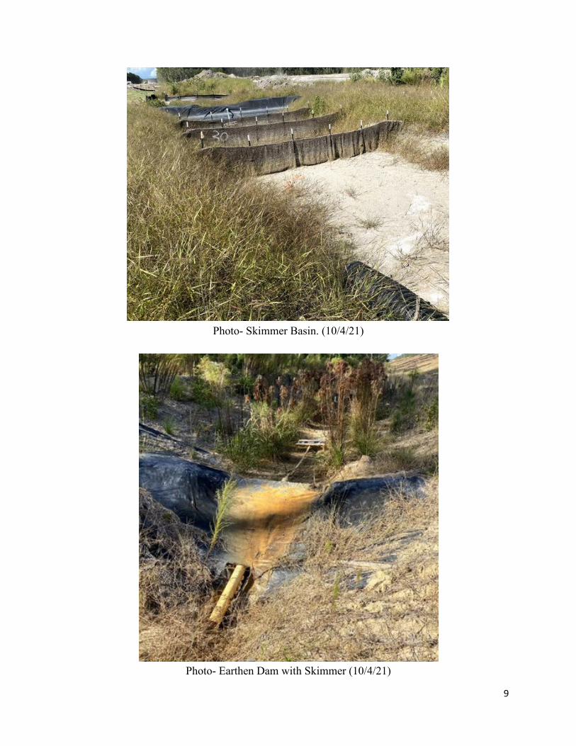
Photo- Skimmer Basin. (10/4/21)
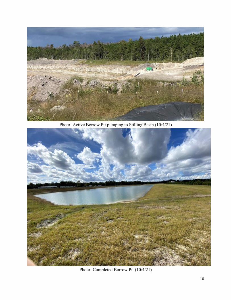
Photo- Earthen Dam with Skimmer (10/4/21)
10
Photo- Active Borrow Pit pumping to Stilling Basin (10/4/21)
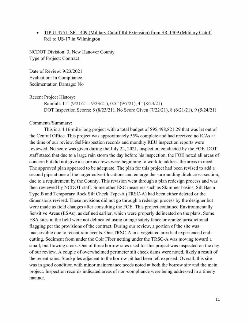
Photo- Completed Borrow Pit (10/4/21)
11
• TIP U-4751: SR-1409 (Military Cutoff Rd Extension) from SR-1409 (Military Cutoff Rd) to US-17 in Wilmington
NCDOT Division: 3, New Hanover County Type of Project: Contract Date of Review: 9/23/2021 Evaluation: In Compliance Sedimentation Damage: No Recent Project History: Rainfall: 11” (9/21/21 - 9/23/21), 0.5” (9/7/21), 4” (8/23/21) DOT Inspection Scores: 8 (8/23/21), No Score Given (7/22/21), 8 (6/21/21), 9 (5/24/21) Comments/Summary:
This is a 4.16-mile-long project with a total budget of $95,498,821.29 that was let out of the Central Office. This project was approximately 55% complete and had received no ICAs at the time of our review. Self-inspection records and monthly REU inspection reports were reviewed. No score was given during the July 22, 2021, inspection conducted by the FOE. DOT staff stated that due to a large rain storm the day before his inspection, the FOE noted all areas of concern but did not give a score as crews were beginning to work to address the areas in need. The approved plan appeared to be adequate. The plan for this project had been revised to add a second pipe at one of the larger culvert locations and enlarge the surrounding ditch cross-section, due to a requirement by the County. This revision went through a plan redesign process and was then reviewed by NCDOT staff. Some other ESC measures such as Skimmer basins, Silt Basin Type B and Temporary Rock Silt Check Type-A (TRSC-A) had been either deleted or the dimensions revised. These revisions did not go through a redesign process by the designer but were made as field changes after consulting the FOE. This project contained Environmentally Sensitive Areas (ESAs), as defined earlier, which were properly delineated on the plans. Some ESA sites in the field were not delineated using orange safety fence or orange jurisdictional flagging per the provisions of the contract. During our review, a portion of the site was inaccessible due to recent rain events. One TRSC-A in a vegetated area had experienced end-cutting. Sediment from under the Coir Fiber netting under the TRSC-A was moving toward a small, but flowing creek. One of three borrow sites used for this project was inspected on the day of our review. A couple of overwhelmed perimeter silt check dams were noted, likely a result of the recent rains. Stockpiles adjacent to the borrow pit had been left exposed. Overall, this site was in good condition with minor maintenance needs noted at both the borrow site and the main project. Inspection records indicated areas of non-compliance were being addressed in a timely manner.

12
Photo - End cutting around Temporary Rock Silt Check-Type A. (9/23/21)
Photo – Culvert and additional pipe installed, and ditch graded. (9/23/21)

13
Photo - Overwhelmed TRSC-A with minor sediment loss at Borrow Pit. (9/23/21)

14
• TIP U-2714: US-117A (North Williams St) from North of US-70 to SR-1571 (Tommy’s Road)
NCDOT Division 4, Wayne County Type of Project: Contract Date of Review: 9/30/21 Evaluation: In Compliance Sedimentation Damage: No Recent Project History:
Rainfall: 0.11” (9/9/21), 0.75” (9/22/21), 0.22” (9/23/21) DOT Inspection Scores: 8-Project and Borrow Pit (9/16/21), 8-Project and Borrow Pit
(8/16/21), 8-Project/9-Borrow Pit (7/15/21) Comments/Summary:
This is a 1.546-mile-long project with a budget of $15,346,704.64 that was let out of the Central Office. This project was approximately 37% complete and had received no ICAs at the time of our review. Self-inspection records and monthly REU inspection reports were reviewed and appeared consistent and well maintained. The approved plan appeared to be adequate. The plan for the borrow pit and laydown area had been revised to add two skimmer basins and diversions due to a change in exposed areas. These revisions went through a plan redesign process and were then approved by NCDOT staff. This project contained ESAs which were delineated properly on the plans as well as in the field. During our review, we conducted an inspection of the site, borrow pit and laydown area. Curb and gutter were being poured as the active side of the project was approaching completion and work would soon transition to the remaining side of the project. The basins and diversions in the lay down area had been installed and appeared to be functioning. The clean water diversions and stilling basin for dewatering on the borrow site had been installed. One basin at the beginning of the project had been installed but was not receiving much flow and had become overgrown with vegetation. DOT staff stated that as construction transitions to the next phase this basin will receive more flow. DEMLR staff recommended that the basin be mowed enough to ensure that the skimmer would function properly and that baffles could be inspected and maintained. Measures throughout the project appeared to be installed properly and well-maintained. Areas appeared to be stabilized appropriately as they were being completed. Overall, the site was in good condition and areas of concern were being addressed in a timely manner.

15
Photo- Skimmer Basins installed in laydown area (9/30/21)
Photo- Stilling basin for Borrow Pit dewatering (9/30/21)

16
Photo- Culvert completed, surrounding areas stabilized (9/30/21)
Photo- Recently graded ditch with Wattles (9/30/21)

17
• TIP I-5700: I-40 and SR-3015 Interchange and I-40 Westbound from SR-3015 to I-540 NC DOT Division 5, Wake County Type of Project: Contract Date of Review: 7/14/21 Evaluation: In Compliance Sedimentation Damage: No Recent Project History: DOT Inspection Scores: 8 (6/24/21), 8 (5/24/21), 8 (4/20/21) Comments/Summary:
This is a 0.798-mile-long project with a budget of $34,895,402.71 that was let out of the Central Office. This project was approximately 60% complete at the time of our review. Self-inspection records and Monthly REU inspection reports were reviewed. The recordkeeping for this project was consistent and well maintained. The approved plan appeared to be adequate. This project received an ICA on February 10, 2021, as the result of the monthly REU site inspection. REU staff found multiple areas where sediment loss had occurred, and there was potential for future loss and multiple maintenance needs throughout the site. REU staff conducted a follow-up inspection on February 17, 2021. During this inspection, staff found that the contractor was actively working to resolve areas noted in the ICA but found several erosion control concerns that had not yet been addressed. An ICA Extension was issued with a follow-up inspection scheduled for February 24, 2021. During this follow-up the site was found to be in-compliance and the ICA was lifted. Following the ICA, recommendations were made to add a sediment basin in one corner of the site. This revision was reviewed and approved by the REU. The basin had been installed and appeared to be functioning properly and well maintained. Slope drains and inlet protections throughout the site were being maintained. Slopes and disturbed areas were being seeded and mulched with straw and tack or matted per the approved plan. The bottom of one section of ditch was starting to erode and needed to be repaired and re-stabilized. Overall, this site was in compliance with just a few minor maintenance needs noted.

18
Photo- Ditch bottom beginning to erode. (7/14/2021)
Photo- Culvert installed and area stabilized. (7/14/2021)
19
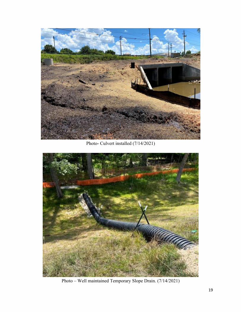
Photo- Culvert installed (7/14/2021)
Photo – Well maintained Temporary Slope Drain. (7/14/2021)

20
• Bridge 239 Over Burnt Swamp NC DOT Division 6, Robeson County Type of Project: Contract Date of Inspection: 8/31/2021 Evaluation: In Compliance Sedimentation Damage: No Recent Project History: Rainfall: 0.5” (8/2/21), 0.3” (8/4/21), 1.3” (8/7/21) DOT Inspection Scores: 9 (6/01/21), 9 (7/6/21), 9 (8/4/21) Comments/Summary:
This is a 0.095-mile-long bridge replacement project with a budget of $514,743.20 that was let out of the Division Office. This project was approximately 95% complete and had received no ICAs at the time of our inspection. Self-inspection records and monthly REU inspection reports were reviewed and appeared consistent and well maintained. The plan appeared to be adequate, and no revisions had been made to the original plan. Construction had been completed and this project had transitioned into the final vegetative establishment phase. All measures appeared to be properly installed and maintained. DOT staff indicated that measures would stay in place until final vegetation had established. Overall, this site was in good condition and was establishing a good stand of vegetation.
Photo -Bridge construction completed (8/31/21)

21
Photo – Final vegetation being established (8/31/21)
Photo- Silt fence and wattle breaks installed and maintained (8/31/21)

22
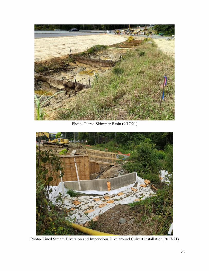
• TIP U-2581BA: US-70 from West of SR-3045 (Mt. Hope Church Rd.)/SR-2819 (McLeansville Rd.) to East of SR-2826 (Birch Creek Rd.)
NCDOT Division 7, Guilford County Type of Project: Contract Date of Review: 9/17/2021 Evaluation: In Compliance Sedimentation Damage: No Recent Project History: Rainfall: 0.375” (9/16/21), 0.625” (9/1/21), 0.625” (8/20/21) DOT Inspection Scores: 8 (8/24/21), 8 (7/14/21), 8 (6/17/21) Comments/Summary:
This is a 1.49-mile-long project with a budget of $11,125,538.10 that was let out of the Central Office. This project was approximately 85% complete and had received no ICAs at the time of our review. Self-inspection records and monthly REU inspection reports were reviewed and appeared consistent and well maintained. A tiered skimmer basin size had been revised and the number of tiers had been reduced due to field conditions. This revision went through a redesign process, reviewed by REU staff and added to the As-Built plan sets onsite. This project contained ESAs which were all properly delineated in the field; however, two areas within Riparian Buffers had not been properly delineated on the plans according to NCDOT Design Manual requirements. During our review, a culvert was being replaced. This replacement involved pumping the stream around in a lined diversion. The work area was being dewatered by pumping through a special stilling basin. Finished ditches had been matted and wattles or check dams had been installed per the plan. Overall, this site appeared to be stabilizing appropriately with minor maintenance needs noted. Previous REU inspection reports and Self-inspection records indicated some sediment loss, but all areas of concern were indicated to be corrected within a timely manner.
23
Photo- Tiered Skimmer Basin (9/17/21)
Photo- Lined Stream Diversion and Impervious Dike around Culvert installation (9/17/21)

24
Photo- Special Sediment Control Fence adjacent to Wetlands (9/17/21)
Photo- Storm Drain Outlet (9/17/21)

25
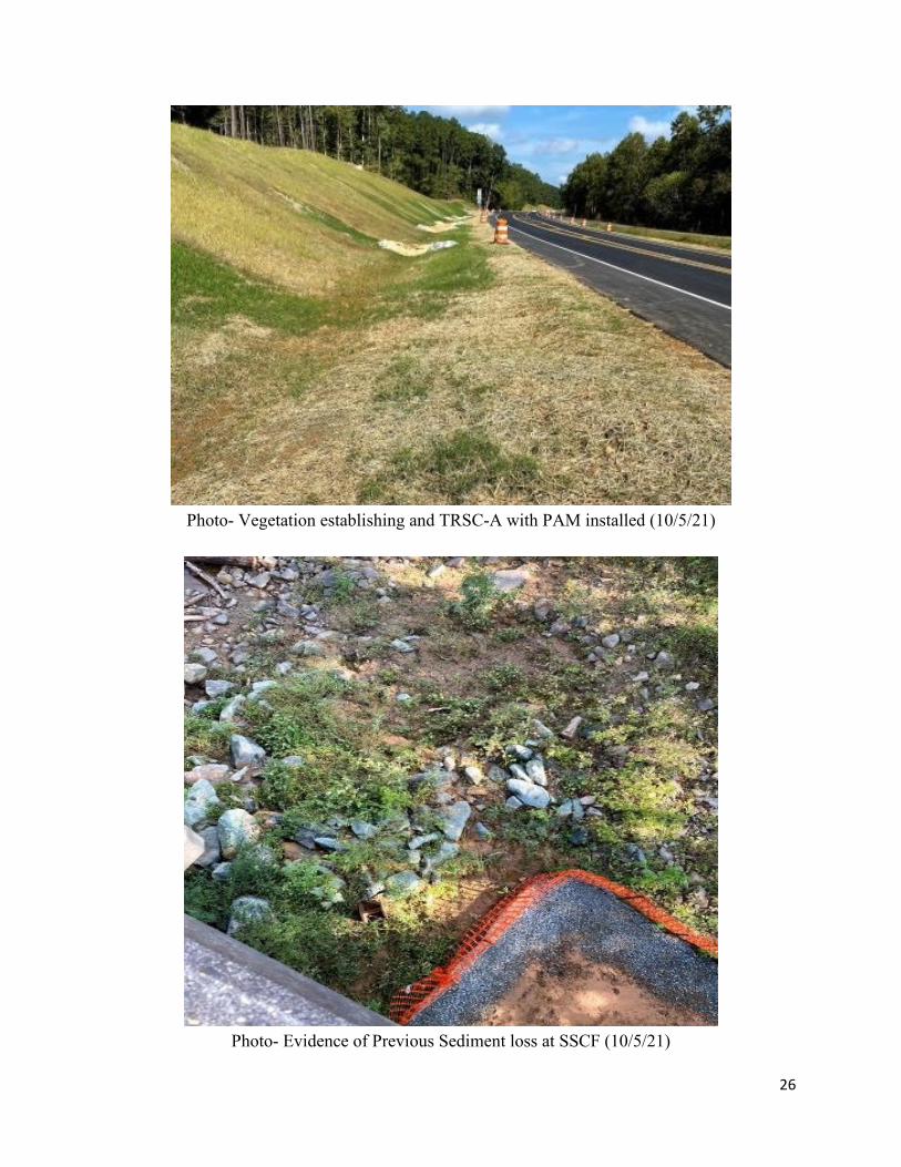
• TIP B-4968: Bridge #10 Over the Deep River on US-15/501 and NC-87 NCDOT Division 8, Chatham/Lee County Type of Project: Contract Date of Review: 10/5/2021 Evaluation: In Compliance Sedimentation Damage: No Recent Project History: Rainfall: 1.85” (9/23/21), 1.52” (9/22/21), 0.1” (9/9/21) DOT Inspection Scores: 7 (9/28/21), 8 (8/27/21), 9 (7/22/21) Comments/Summary:
This is a 0.947-mile-long bridge replacement project with a budget of $8,861,891.53 that was let out of the Central Office. This project was approximately 80% complete and had received no ICAs at the time of our review. Some self-inspection records were missing the priority ranking for corrective actions as well as the date that corrective actions had been taken. These inconsistencies had been noted on multiple Monthly REU reports. At the time of our review, the new bridge construction had been completed and traffic had been shifted to the new bridge. The existing bridge had yet to be removed. The finished ditch line and slopes were stabilized well with grass starting to vegetate. TRSC-As with polyacrylamide (PAM) were installed and appeared well maintained. Areas of reoccurring concern and sediment loss had been noted on REU Monthly inspection reports. One of these areas was a section of Special Sediment Control Fence (SSCF) below the existing bridge. This area appeared to have been recently maintained with signs of previous loss still evident. Overall, this site was in decent condition, with maintenance needs throughout.
26
Photo- Vegetation establishing and TRSC-A with PAM installed (10/5/21)
Photo- Evidence of Previous Sediment loss at SSCF (10/5/21)

27
Photo- Ditch line measures installed (10/5/21)

28
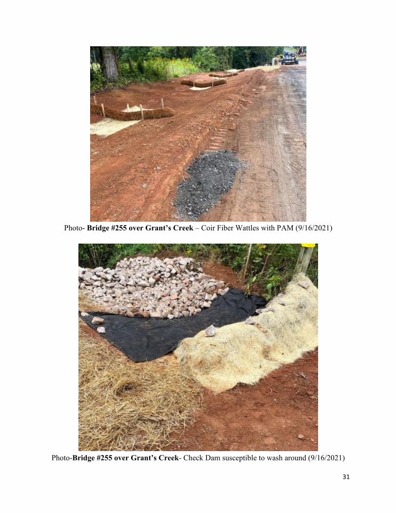
• Bridge #64 over Beaverdam Creek on SR-1952 and Bridge #255 over Grant’s Creek on SR-1503
NCDOT Division: 9, Rowan County Type of Projects: Contract Date of Review: 9/16/2021 Evaluation: Both Bridges in Compliance Sedimentation Damage: No Recent Project History: Rainfall: Bridge #64: 0.41” (9/9/21), 0.01” (9/7/21), 0.72” (9/2/21) Bridge #255: 0.01” (9/10/21), 0.23” (9/9/21), 0.06” (9/7/21) DOT Inspection Scores:
Bridge #64: 8 (9/8/21), 8-Overall Project/7-End Bent 2 Side (8/23/21), 8 (8/3/21) Bridge #255: 8 (9/8/21), 8 (8/23/21), 8 (8/3/21)
Comments/Summary: Bridge #64 over Beaverdam Creek:
This is a 0.134-mile-long bridge replacement project with a total budget of $814,268.77 that was let out of the Division Office. This project was approximately 20% complete and had received no ICAs at the time of our review. Self-inspection records and monthly REU inspection reports were reviewed and appeared consistent and well maintained. The approved plan was adequate. The approved plan called for impervious dikes to line the banks of the stream during construction, but these dikes were not being used. The FOE was consulted and approved the deletion of these measures but required that additional silt fence be installed at the top of the stream bank. These revisions were noted on the plans kept on-site. During our review, the existing bridge had been removed and the new end bents were being installed. The stream banks had been stabilized with Coir Fiber matting. Inactive or completed areas had been seeded and mulched with straw. Silt fence and checks appeared to be maintained throughout the site. Overall, this site appeared to be implementing the approved plan correctly and well maintained.

29
Photo- Bridge #64 over Beaverdam Creek- Additional Silt Fence (9/16/2021)
Photo- Bridge #64 over Beaverdam Creek- Finished End Bent stabilized (9/16/2021)

30
Bridge #255 over Grant’s Creek: This is a 0.095-mile-long bridge replacement project with a total budget of $547,804.92
that was let out of the Division office. This project was approximately 60% complete and had received no ICAs at the time of our review. Self-inspection records and monthly REU inspection reports were reviewed and appeared consistent and well maintained. The approved plan was adequate. Throughout the site, Coir Fiber Wattles with PAM had been used in place of TRSC-B. These substitutions had been approved by the FOE. This project was transitioning to the final grade phase and had installed measures the day prior after grading had been completed. One TRSC-A with Matting and PAM had been installed but did not extend all the way across the ditch and may start to wash around during future rain events. Overall, this site was in good condition and appeared to be transitioning properly between phases.
Photo- Bridge #255 over Grant’s Creek – Area around Bridge being stabilized (9/16/2021)
31
Photo- Bridge #255 over Grant’s Creek – Coir Fiber Wattles with PAM (9/16/2021)
Photo-Bridge #255 over Grant’s Creek- Check Dam susceptible to wash around (9/16/2021)

32
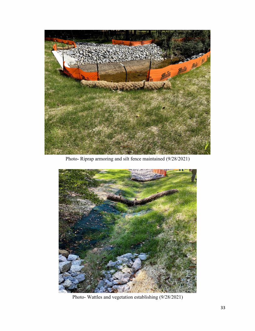
• Bridge #234 over Cabbage Branch on SR-1637 NCDOT Division: 10, Anson County Type of Project: Contract Date of Review: 9/28/2021 Evaluation: In Compliance Sedimentation Damage: No Recent Project History: Rainfall: 0.25” (8/31/21), 0.75” (8/26/21), 1.5” (8/17/21) DOT Inspection Scores: 8 (9/1/21), 8 (8/16/21), 8 (7/20/21) Comments/Summary: This is a 0.1-mile-long bridge replacement project with a total budget of $411,909.30 that was let out of the Division office. This project was approximately 98% complete and had received no ICAs at the time of our review. This project consisted of replacing and upsizing a concrete box culvert and had been completed with the final construction inspection conducted on 9/3/21. Self-inspection records and monthly REU inspection reports were reviewed and appeared consistent and well maintained. During our review of the contract documentation, we were unable to find the Stream Impact Permit plan set which shows all approved work under the 404/401 permits. This plan set is typically included in the contract following the permit documents. DOT staff was unsure why these plans were not included in the contract but indicated that this set was given to the contractor during the Pre-construction meeting, if not before. The approved plan appeared adequate. DOT staff indicated that no major revisions or deviations had been made from the approved plan and therefore, a set of ESC As-Built plans was not kept and updated throughout the project. During construction, an increased flow through the ditches was noted and DOT staff recommended that Coir Fiber Wattles be replaced with TRSC-A to handle the high flows during rain events. Riprap armoring on both the inlet and outlet side of the culvert appeared stable and well maintained. Overall, permanent vegetation was establishing well, and measures appeared to be maintained.
33
Photo- Riprap armoring and silt fence maintained (9/28/2021)
Photo- Wattles and vegetation establishing (9/28/2021)

34
• TIP BR-0124: Bridge #166 over West Prong Roaring River on SR-1745 and TIP BR-0125: Bridge #663 over East Prong Roaring River on SR-1002
NC DOT Division: 11, Wilkes County Type of Projects: Contract Date of Review: 8/25/2021 Evaluation: Both Bridges in Compliance Sedimentation Damage: No Recent Project History: Rainfall:
BR-0124: 3.5” (8/18/21), 0.5” (8/17/21), 1.5” (8/16/21) BR-0125:, 0.75” (8/15/21), 0.75” (8/14/21), 1.0 inches (8/12/21)
DOT Inspection Scores: BR-0124: 9 (8/3/21), 9 (7/1/21), 9 (6/16/21) BR-0125: 8 (8/3/21), 9 (7/1/21), 9 (6/16/21)
Comments/Summary: TIP BR-0124:
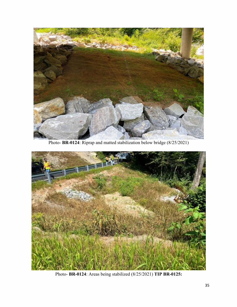
This is a 0.12-mile-long bridge replacement project with a total budget of $921,190.10. This project was approximately 90% complete and had received no ICAs at the time of our review. Self-inspection records and monthly REU inspection reports were reviewed and appeared consistent and well maintained. The approved plan appeared adequate. Minor revisions to the right of way and the riprap channel of a pipe outfall had been shortened. These revisions had not been marked up on the plans kept on-site. All revisions had been approved by the NC DEQ Division of Water Resources (DWR) prior to being implemented in the field. This project had transitioned into the final vegetative establishment phase. All disturbed areas had been seeded and final cover was being established. Overall, the site was in good condition.
35
Photo- BR-0124: Riprap and matted stabilization below bridge (8/25/2021)
Photo- BR-0124: Areas being stabilized (8/25/2021) TIP BR-0125:
36
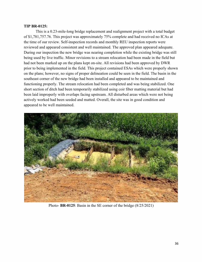
TIP BR-0125: This is a 0.23-mile-long bridge replacement and realignment project with a total budget
of $1,781,757.76. This project was approximately 75% complete and had received no ICAs at the time of our review. Self-inspection records and monthly REU inspection reports were reviewed and appeared consistent and well maintained. The approved plan appeared adequate. During our inspection the new bridge was nearing completion while the existing bridge was still being used by live traffic. Minor revisions to a stream relocation had been made in the field but had not been marked up on the plans kept on-site. All revisions had been approved by DWR prior to being implemented in the field. This project contained ESAs which were properly shown on the plans; however, no signs of proper delineation could be seen in the field. The basin in the southeast corner of the new bridge had been installed and appeared to be maintained and functioning properly. The stream relocation had been completed and was being stabilized. One short section of ditch had been temporarily stabilized using coir fiber matting material but had been laid improperly with overlaps facing upstream. All disturbed areas which were not being actively worked had been seeded and matted. Overall, the site was in good condition and appeared to be well maintained.
Photo- BR-0125: Basin in the SE corner of the bridge (8/25/2021)

37
Photo- BR-0125: Permanent Ditch (left) and Stream Relocation (Right) (8/25/2021)
Photo- BR-0125: Coir Fiber laid as matting and Wattles installed (8/25/2021)

38
• TIP I-3819B/U-6039: I-40/I-77 Interchange: I-40 from SR 2003 to SR 2158; I-77 from SR 2171 to SR 2321; and SR 2321 from Vine Street to SR 2422
NCDOT Division: 12, Iredell Type of Project: Contract Date of Review: 9/29/2021 Evaluation: In Compliance Sedimentation Damage: No Recent Project History: Rainfall: 0.21” (9/16/21), 1.07” (9/1/21), 0.81” (8/31/21) DOT Inspection Scores: 8 (9/15/21), 8 (8/2/21), 8 (7/13/21) Comments/Summary:
This is a 4.0-mile-long project with a total budget of $260,290,000 that was let out of the Central Office. This project was approximately 50% complete at the time of our review and had received no ICAs at the time of our review. Self-inspection records and monthly REU inspection reports were reviewed and found to be adequate. Previous off-site sedimentation was noted in the monthly REU reports as well as Self-inspection records. When these losses were discovered, the Resident Engineer halted all production work until urgent corrective actions had been completed throughout the project. Reports indicated that in all instances corrective actions were completed within 3-days and production was allowed to resume. This plan had undergone revisions in response to comments from the FOE and as a result of the need for an intermediate phasing plan. These revisions consisted of resizing one skimmer basin and adding two others. These changes underwent a redesign process, were reviewed by the DOT and had been added to the plans onsite appropriately. This project did not contain any ESAs; however, jurisdictional features and wetland areas were present. Orange safety fencing appeared to have been recently installed in these areas. Fencing had been draped over the upstream side of the silt fence in these areas. Active grading was occurring during our review. One skimmer basin outlet was buried. A culvert extension and channel change had been completed and stabilized appropriately. Matting and slope drains had been installed throughout the site; however, some slope drains did not include stakes in which to secure them. Overall, this project was in good condition with general maintenance needs noted throughout the site.

39
Photo- Channel change and slopes stabilized (9/29/21)
Photo- Safety Fence draped on the upstream side of silt fence (9/29/21)

40
Photo- Culvert extension and Channel Stabilization (9/29/21)
Photo- Basin needing maintenance and skimmer outlet did not daylight (9/29/21)
41
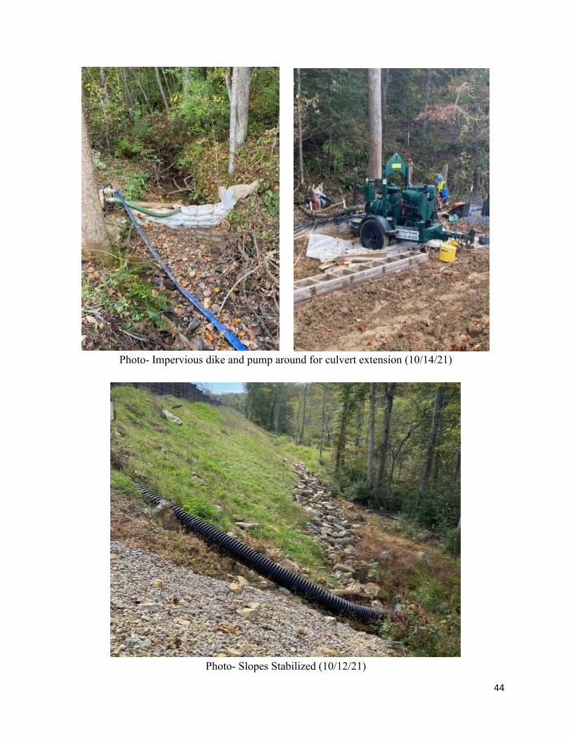
• TIP I-4700: I-26 from NC-280 (Exit 80) to I-40 NCDOT Division: 13, Buncombe/Henderson County Type of Project: Contract Date of Review: 10/14/2021 Evaluation: In Compliance Sedimentation Damage: No Recent Project History: Rainfall: 2.1” (10/8/21-10/9/21), 1.3” (10/4/21-10/6/21), 0.6” (9/23/21)
DOT Inspection Scores: 8-Permitted Areas/7-Remainder of Project (9/9/21), 8 (8/11/21), 8 (7/15/21)
Comments/Summary:
This is a 7.49-mile-long project with a total budget of $263,070,00 that was let out of the Central Office. This project was approximately 35% complete at the time of our review. Self-inspection records and monthly REU reports were reviewed and found to be adequate. The approved plan appeared to be adequate. This project contains ESAs which were properly delineated on both the plans as well as in the field. This project received an ICA on November 13, 2020, during the monthly REU inspection. REU Staff found that one stream through the site was running turbid and that a basin upstream of this area had been filled in without first dewatering the basin. Several maintenance and measure installation needs were noted on the ICA as well. DWR was notified about the losses into the stream and advised corrective actions needed. All corrective actions were found to have been made during the follow-up inspection conducted by REU staff on November 18, 2020, at which time the ICA was lifted. Some skimmer basins had to be resized or shifted from the proposed plan due to field conditions. Several additional Silt Basin Type-Bs had been added throughout the project. All revisions, deviations or additions from the approved plan were approved by the FOE but did not undergo a redesign process. One section of silt fence below a basin had undermined and been filled in with stone. Signs of previous sediment loss were evident here. A section of SSCF had been overwhelmed and sediment could be seen beyond the fence line. This sediment deposit was still within the project boundaries and no signs of encroachment to the French Broad River were evident. DOT staff indicated that this was a reoccurring area of concern, but no losses had reached beyond the project limits. Basins throughout the project had been installed and appeared to be functioning properly. Finished slopes and stockpiles seen throughout the project had been stabilized appropriately. Maintenance needs throughout the site and some sediment loss beyond perimeter measures was noted but did not appear to have left the project limits. Overall, this project appeared to have measures installed and maintained per the approved plan, and completed areas were being stabilized.

42
Photo- Sediment deposited beyond SSCF (10/14/21)
Photo- Cleared ESA (10/14/21)

43
Photo- SSCF needing maintenance (10/14/21)
Photo-Recently Installed Basin (10/14/21)
44
Photo- Impervious dike and pump around for culvert extension (10/14/21)
Photo- Slopes Stabilized (10/12/21)

45
• TIP A-0011C: NC-69 from the Georgia Line to US-64 NCDOT Division: 14, Clay County Type of Project: Contract Date of Review: 10/13/2021 Evaluation: In Compliance Sedimentation Damage: No Recent Project History: Rainfall: 4.25” (10/4/21-10/7/21), 0.65” (9/21/21), 0.30” (9/19/21)
DOT Inspection Scores: 8-Project/10-Waste Site (9/13/21), 8 (8/12/21), 8 (7/12/21) Comments/Summary:
This is a 3.80-mile-long project with a total budget of $46,327,228.88 that was let out of the Central Office. This project was approximately 50% complete and had received no ICAs at the time of our review. Self-inspection records and monthly REU reports were reviewed and found to be adequate. The approved plan appeared to be adequate. One skimmer basin had not been installed due to safety concerns with its placement. The FOE was consulted and approved this deletion, requiring that a Temporary Rock Silt Check Type B (TRSC-B) be installed instead. All revisions had been properly indicated on the plans on-site. This project contained an on-site stream mitigation plan which had been completed. Rills had begun to form beneath the kudzu above the inlet of one skimmer basin which also had a wood pole laying across one of the baffles. A section of the first baffle in a Temporary Silt Check Dam Type B (TRSD-B) had been knocked down and needed to be repaired or replaced. Another TRSD-B had been partially removed during recent grading. DOT staff stated that this measure would be reconfigured at a reduced size to still function until the area had been completely stabilized. During our review, we inspected two of the three waste sites for this project. One waste site was active with a skimmer basin and clean water diversions installed. Minor sediment tracking onto the road was noted and it was suggested that additional stone be added to the construction entrance which had previously been paved. The other waste site had been completed, stabilized and released back to the owner. This project appeared to be following the approved ESC plan and completed areas were stabilizing. Some minor maintenance needs were noted throughout but overall, this site was in good condition.
46
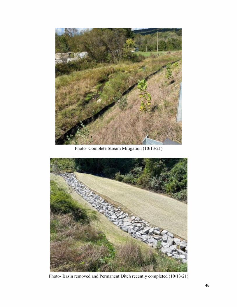
Photo- Complete Stream Mitigation (10/13/21)
Photo- Basin removed and Permanent Ditch recently completed (10/13/21)

47
Photo- Wood pole laying across Baffle (10/13/21)
Photo- Section of first baffle knocked down in TRSD-B (10/13/21)
48
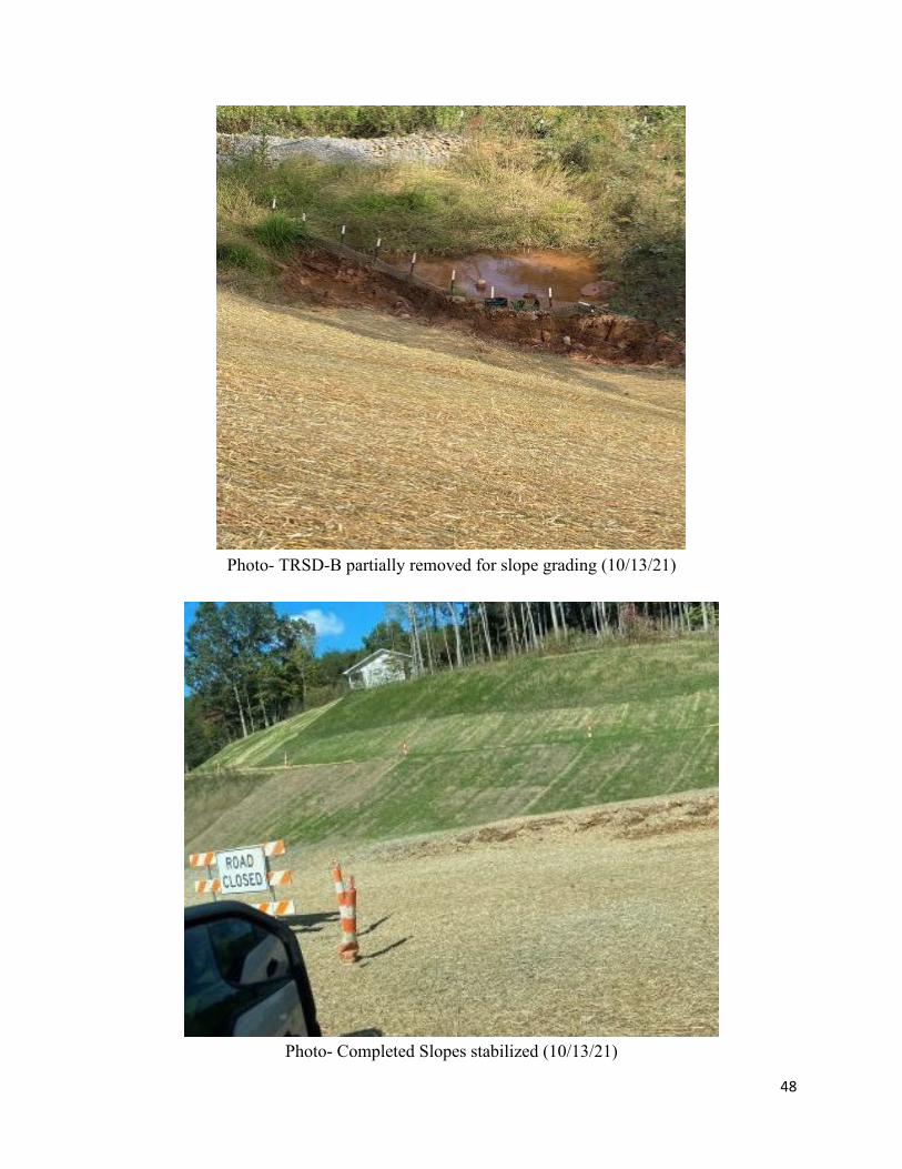
Photo- TRSD-B partially removed for slope grading (10/13/21)
Photo- Completed Slopes stabilized (10/13/21)
49
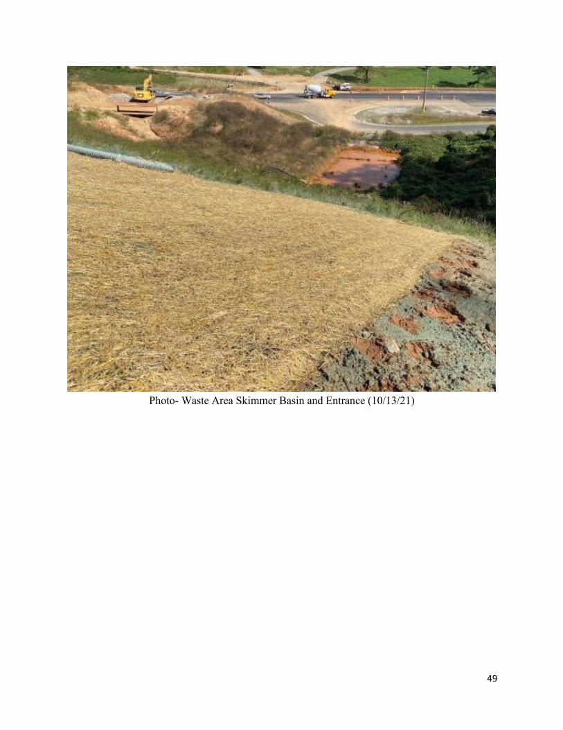
Photo- Waste Area Skimmer Basin and Entrance (10/13/21)

50
Positive Findings
• DOT Internal Inspection Process The NCDOT is responsible for two types of inspections on each project: NPDES/SPCA Self-
Monitoring Inspections (Self-inspections) and monthly REU inspections. Self-inspections for all active projects are conducted at least weekly and within 24 hours of a rain event of 1.0 inch or greater, by a project inspector from the office of the resident engineer or their designee on Contract Construction or from the county or district engineer for maintenance on State Force/Operations projects. Weekly project inspections and monthly REU inspections were reviewed for each project. Monthly REU inspections appeared consistent across all the divisions and were well maintained on all projects reviewed. Some inconsistencies on the self-inspections, such as the date corrective actions were completed, were noted on two projects. In most cases this inconsistency had been previously noted on the REU monthly inspections, and in one case this was a reoccurring comment throughout the life of the project.
• Communication and Project Progression
Pre-construction meetings are held with the contractor on every project. In addition, monthly meetings are held between Department staff and the contractor’s workforce to discuss erosion control and other items that may need attention throughout the life of the project. When questioned, it appeared there was good communication between the division erosion control inspector, Resident Engineer, and the Division Field Operations Engineers (FOEs).
• Educational Efforts NCDOT has contracted with N.C. State University to train and certify contractors and staff in
the design, management and installation of sedimentation and erosion control practices. There are three levels of certification: Level One certifications for installers, Level Two certifications for inspectors and Level Three certifications for designers. Certification is required to work on a DOT project. NCDOT is also funding extensive research on innovative sedimentation and turbidity control measures.
• Innovative Approach Some innovative approaches for sediment control were noticed during the review, such as the
use of flocculants on nearly every one of its projects statewide. Almost every project involved in this review had either used or planned to use measures with polyacrylamide (PAM) during the construction process. PAM was often applied to check dams or wattles along diversion ditches leading to sediment basins, traps, or discharge points. The plans were drawn such that the last device before discharging into jurisdictional waters were to be PAM-free. The use of flocculants helps to keep sediment on site and our waters clean.

51
Issues Noted and Recommendations
• Document Updates Several changes have occurred in recent years to the Sedimentation Pollution Control Act of
1973, the State Construction Stormwater General Permit, and Chapter 04 of Title 15A of the North Carolina Administrative Code dealing with erosion and sedimentation. Some of these changes affect transportation projects. The NCDOT has adapted to some of these changes. For instance, reclamation procedures for in-house operations and contract projects include the latest administrative code requirements for disturbances within High Quality Waters. Self-inspection forms provided for contractors have been updated. However, the Stabilization Requirements special provision and Soil Stabilization Timeframes Table provided in project contracts and in the ESC plans, respectively are slightly outdated and should be updated to reflect the most recent requirements found in Table 3 of Part II, Section E of the 2019 NCG01 General NPDES Permit. Some sections of the NCDOT Erosion and Sediment Control Design and Construction Manual and certain guidance documents need to be updated to reflect the latest changes in the NC Administrative Code which became effective on June 1, 2020. Land Quality staff informed the NCDOT of these inconsistencies with the latest regulations upon discovery, and most have since been corrected. A thorough review of all related specifications, provisions, drawings, and manuals should be made to ensure standards and guidance reflect current regulatory language.
• DEMLR Notification Some NCDOT Divisions and Districts are communicating properly with the DEMLR Land
Quality Section (LQS), although the majority are not notifying DEMLR staff per the delegation requirements. The Division Engineer is to include the Regional Land Quality Engineer on the list of invited attendees for preconstruction conferences for projects involving significant land disturbing activity. The NCDOT Resident Engineer is to notify the Regional Land Quality Engineer when construction begins. As part of this notification, the Resident Engineer is to include the name of the technician who will be on the project and responsible for inspecting sediment and erosion activities and who will be maintaining the continuously updated erosion control plans. This is in accordance with the Department’s program delegation. Additionally, one set of the Erosion and Sediment Control plans is to be sent to the Regional Land Quality Engineer. NCDOT staff are also to notify DEMLR LQS of any significant sediment loss as well as notify the DWR for losses into a stream or wetland. It was discovered that the NCDOT is currently notifying DWR but not always notifying DEMLR LQS in these cases. The State Roadside Environmental Field Operations Engineer was reminded of this delegation requirement, and has since instructed his staff of the notification requirements.
52
• Plan Revision Reviews The NCDOT should reconsider when it is appropriate to make in-field revisions/plan mark
ups and when a plan needs to be revised and go back through a design and review process. Throughout our review we noted multiple instances where significant deviations from the plan, such as basin relocation, resizing or deleting measures from the plan were made as simple field revisions as opposed to a plan revision with a redesign and subsequent plan review. While minor alterations, such as silt fence additions or alignment adjustments can be handled with red line drawings, any significant deviation or alteration to a plan should result in a plan revision and review to ensure that proposed measures will be adequate for site conditions.
• Construction Staking for Project Limits and Environmentally Sensitive Areas The NCDOT’s jurisdiction for delegation consists of land which is inside their right-of-way
and easements. The Department has provisions in place for staking or otherwise delineating their right-of-way and permanent easements needed for work such as clearing and grubbing, drainage or bridge installations, and related stream or wetland impacts. Rights-of-way and easements were clearly shown on the plans. These items should be clearly marked in the field as well as on the plans, and any stakes should be re-installed if inadvertently damaged or removed.
The delineation of areas draining to certain classes of jurisdictional water bodies is a proactive measure by the Department to require special working conditions around sensitive waterbodies. Delineation of these sensitive areas on the plans is required of consultants and in-house design engineers. Delineation of these sensitive areas in the field is required of contractors through the plans and contract documents. Some inconsistencies were discovered during plan reviews and site visits. The NCDOT is encouraged to thoroughly review plans and inspect the project site to ensure that these requirements are being met before beginning operations or letting projects out for bidding and upon initial project inspection.
• Matting Specification Matting for erosion control is included on the Soil Stabilization Summary Sheet within
erosion and sediment control plan set. This table includes the location for placement along with the estimated quantity needed. A construction detail for matting installation is referenced on the plans under the list of standard drawings shown on the title page. The type of matting is not indicated on the Soil Stabilization Summary Sheet table, in a construction detail or anywhere within the plan set. Two approved types of matting for erosion control (excelsior and straw) are specified in the 2018 Standard Specifications for Roads and Structures. It is recommended that the type of matting to be used be shown either on the plans at the locations to be installed or within the Soil Stabilization Summary Sheet. For matting materials other than excelsior and straw, such as Coir Fiber Matting or Permanent Soil Reinforcement Matting (PSRM), a special provision is included in the contract with material specifications. These matting types are indicated within the Soil Stabilization Summary Sheet table or at the location of installation within the plans themselves.
53
• Concrete Washout The NCDOT requires any project involving concrete (including those with sidewalks or curb
and gutter) to have a designated concrete washout. No construction detail for a concrete washout is provided within the plans, rather, a link to an example construction detail can be found within a contract special provision. It is recommended that a construction detail for concrete washouts be included in the ESC plan set, similar to how construction details for other special provisions such as skimmer basins, earthen dams with skimmer, coir fiber wattle breaks, etc. are included in the ESC plans.
Conclusion
In general, the projects reviewed were in compliance with some maintenance needs noted. Plans, NPDES/SPCA Self-monitoring records and monthly REU Inspection records were available onsite for all projects reviewed. DOT staff indicated the Field Operations Engineer or Staff Engineer were consulted on all deviations, substitutions, and revisions. However, some of these revisions were significant deviations and should have gone through a redesign and review process. The REU staff has done well to inspect all projects periodically and routinely on a monthly basis. Record keeping and monitoring of erosion and sedimentation control measures was adequate.