Review and streamlining of procedures for describing ... · Explanatory notes and comments Part 0....
43
CONVENTION ON WETLANDS (Ramsar, Iran, 1971) 42 nd Meeting of the Standing Committee Gland, Switzerland, 16-20 May 2011 DOC. SC42-19-01, Addendum 3 Agenda item 10.3 Review and streamlining of procedures for describing Ramsar Sites at designation DRAFT Ramsar Site Information Sheet (RIS) – 2012 revision Explanatory Notes for Standing Committee Note that the column on the right hand side of the page entitled ‘Explanatory notes and comments’ and tinted in grey does not form part of the RIS itself, but rather provides explanation about the derivation of each field. This column will be removed from the final version after adoption. Yellow-highlighted numbers are either internal cross-references or cross-references to the draft 2012 Strategic Framework and are for editorial purposes only. These highlights will be removed from the adopted RIS. In the planned online version of this form, fields back-shaded in light blue relate just to RIS updates and would only become active (i.e., be seen) if field 5b indicates an RIS update. NOTES TO COMPILERS 1. The RIS must be completed in one of the Convention’s three working languages, namely English, French, or Spanish. The RIS and the accompanying Strategic Framework and guidelines for the future development of the List of Wetlands of International Importance of the Convention on Wetlands are available in each of the three working languages. Please read the guidance in the Strategic Framework before starting to complete the Ramsar Information Sheet. It provides significant guidance on each section in the Information Sheet.
Transcript of Review and streamlining of procedures for describing ... · Explanatory notes and comments Part 0....
CONVENTION ON WETLANDS (Ramsar, Iran, 1971) 42nd Meeting of the Standing Committee Gland, Switzerland, 16-20 May 2011
DOC. SC42-19-01, Addendum 3 Agenda item 10.3
Review and streamlining of procedures for describing Ramsar Sites at designation
DRAFT
Ramsar Site Information Sheet (RIS) – 2012 revision
Explanatory Notes for Standing Committee
Note that the column on the right hand side of the page entitled ‘Explanatory notes and comments’ and tinted in grey does not form part of the RIS itself, but rather provides explanation about the derivation of each field. This column will be removed from the final version after adoption.
Yellow-highlighted numbers are either internal cross-references or cross-references to the draft 2012 Strategic Framework and are for editorial purposes only. These highlights will be removed from the adopted RIS.
In the planned online version of this form, fields back-shaded in light blue relate just to RIS updates and would only become active (i.e., be seen) if field 5b indicates an RIS update.
NOTES TO COMPILERS
1. The RIS must be completed in one of the Convention’s three working languages, namely English, French, or Spanish. The RIS and the accompanying Strategic Framework and guidelines for the future development of the List of Wetlands of International Importance of the Convention on Wetlands are available in each of the three working languages. Please read the guidance in the Strategic Framework before starting to complete the Ramsar Information Sheet. It provides significant guidance on each section in the Information Sheet.
DOC. SC42-19-01 Add.3, page 2
2. The information provided by Contracting Parties in the RIS, including any supplementary information provided, and held in the Ramsar Sites Database is also made publicly available through the Ramsar Site Information Service website (http://ramsar.wetlands.org).
3. Important note on completion of fields. Please note that it is not expected that most Contracting Parties will be able to complete all fields
for all Ramsar Sites. Data, information and capacity are all variable worldwide and develop through time. Compilers should consider the following principles:
a) If no information exists relating to a specific field, please leave this field uncompleted (or indicate ‘unknown’). After completing
the RIS, an overall assessment of those issues that are lacking information should guide future priorities for research and survey at the site (for example, within the context of the site’s management plan);
b) Recording some information – even if this is an incomplete or just a provisional assessment – is more useful than giving no
information. Provisional assessments of knowledge are useful and can be expanded in subsequent updates of the RIS, and accordingly, Contracting Parties are urged to complete as much of the form as possible.
c) Please focus on the following sections as priorities for completion (to the extent that information allows: Part 1 (fields 1-11), Part 2 (field
12) and the ecological character statement in field 13 of Part 3. Part 4 (fields 28-35) contains important information on site management and should be completed if possible.
4. Fields back-shaded in light blue relate just to RIS updates. 5. Examples of completed RIS are available on the Ramsar website at www.ramsar.org.xxxxxxx1 and it is strongly advised that these are reviewed
before compiling this form. 6. Note also that some fields (tinted in purple) are not envisaged for completion as part of a standard RIS, but are included for completeness as
part of the format of a ‘full’ Ecological Character Description as given in Resolution X.15.
1 To be developed as soon as possible and in time for the regional meetings
DOC. SC42-19-01 Add.3, page 3
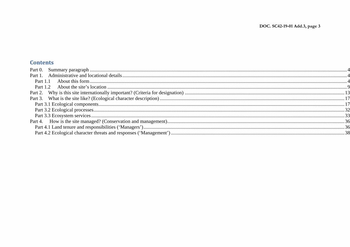
Contents Part 0. Summary paragraph .............................................................................................................................................................................................................. 4 Part 1. Administrative and locational details .................................................................................................................................................................................... 4
Part 1.1 About this form .............................................................................................................................................................................................................. 4 Part 1.2 About the site’s location ................................................................................................................................................................................................ 9
Part 2. Why is this site internationally important? (Criteria for designation) ................................................................................................................................ 13 Part 3. What is the site like? (Ecological character description) .................................................................................................................................................... 17
Part 3.1 Ecological components ..................................................................................................................................................................................................... 17 Part 3.2 Ecological processes ......................................................................................................................................................................................................... 32 Part 3.3 Ecosystem services ........................................................................................................................................................................................................... 33
Part 4. How is the site managed? (Conservation and management) .............................................................................................................................................. 36 Part 4.1 Land tenure and responsibilities (‘Managers’) ................................................................................................................................................................. 36 Part 4.2 Ecological character threats and responses (‘Management’) ........................................................................................................................................... 38
Explanatory notes
and comments
Part 0. Summary paragraph
0. Summary description of the Ramsar Site Please provide a short paragraph summarising the location and key ecological characteristics of the site. This should give a concise summary of the site.
For further guidance see section X.X.X of the Strategic Framework.
Part 1. Administrative and locational details
Part 1.1 About this form
1. Name and address (both postal and email) of those responsible for compiling this form
Name and address: a) Form compiler Name:
Institution/agency:
Postal address:
e-mail:
Fax:
b) National Administrative Authority for the Ramsar Convention
Name:
Field from existing RIS (#1 and #32)
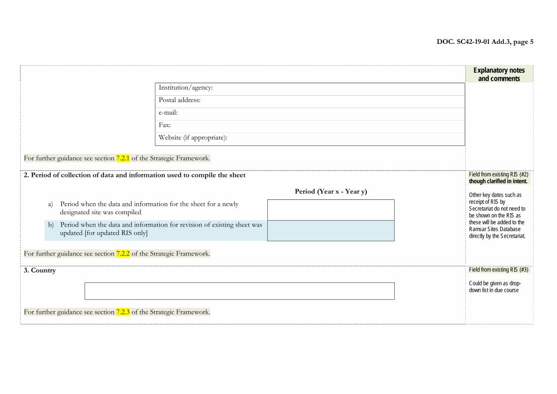
DOC. SC42-19-01 Add.3, page 5
Explanatory notes and comments
Institution/agency:
Postal address:
e-mail:
Fax:
Website (if appropriate):
For further guidance see section 7.2.1 of the Strategic Framework. 2. Period of collection of data and information used to compile the sheet
Period (Year x - Year y)
a) Period when the data and information for the sheet for a newly designated site was compiled
b) Period when the data and information for revision of existing sheet was updated [for updated RIS only]
For further guidance see section 7.2.2 of the Strategic Framework.
Field from existing RIS (#2) though clarified in intent. Other key dates such as receipt of RIS by Secretariat do not need to be shown on the RIS as these will be added to the Ramsar Sites Database directly by the Secretariat.
3. Country
For further guidance see section 7.2.3 of the Strategic Framework.
Field from existing RIS (#3) Could be given as drop-down list in due course

DOC. SC42-19-01 Add.3, page 6
4. Name of the Ramsar Site The official name of the designated site in one of the three official languages (English, French or Spanish) of the Convention. Non-official, alternative names, including in local language(s), can also be given below after the official name.
Official name at designation:
Non-official, alternative name 1
Non-official, alternative name 2
(Add more lines as appropriate if the site has further names) For further guidance see sections 5.11 and 7.2.4 of the Strategic Framework.
Field from existing RIS (#4)
5. Designation of new Ramsar Site or update of information related to an existing Site This RIS is for (tick one box only):
a) Designation of a new Ramsar Site; or
b) Updated information on an existing Ramsar Site.
For further guidance see section 7.2.5 of the Strategic Framework.
Field from existing RIS (#5)
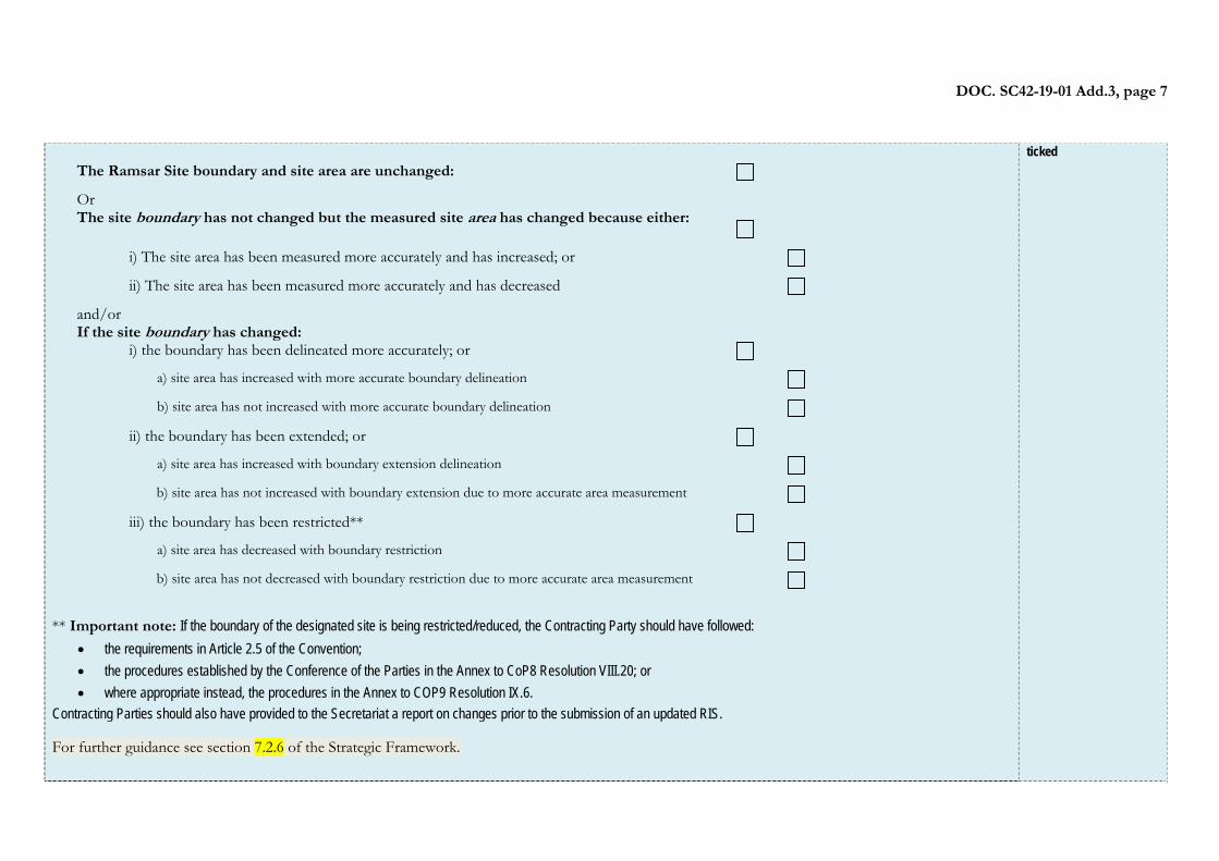
6. Changes to the site since its designation or earlier update. (FOR RIS UPDATES ONLY) 6a) Site boundary and area Please indicate all relevant categories that apply to the Site.
Field from existing RIS (#6a) In the electronic version, this question might only be visible if Q5b was
DOC. SC42-19-01 Add.3, page 7
The Ramsar Site boundary and site area are unchanged: Or The site boundary has not changed but the measured site area has changed because either:
i) The site area has been measured more accurately and has increased; or ii) The site area has been measured more accurately and has decreased
and/or If the site boundary has changed:
i) the boundary has been delineated more accurately; or a) site area has increased with more accurate boundary delineation b) site area has not increased with more accurate boundary delineation ii) the boundary has been extended; or a) site area has increased with boundary extension delineation b) site area has not increased with boundary extension due to more accurate area measurement iii) the boundary has been restricted** a) site area has decreased with boundary restriction b) site area has not decreased with boundary restriction due to more accurate area measurement
** Important note: If the boundary of the designated site is being restricted/reduced, the Contracting Party should have followed:
the requirements in Article 2.5 of the Convention; the procedures established by the Conference of the Parties in the Annex to CoP8 Resolution VIII.20; or where appropriate instead, the procedures in the Annex to COP9 Resolution IX.6.
Contracting Parties should also have provided to the Secretariat a report on changes prior to the submission of an updated RIS. For further guidance see section 7.2.6 of the Strategic Framework.
ticked
DOC. SC42-19-01 Add.3, page 8
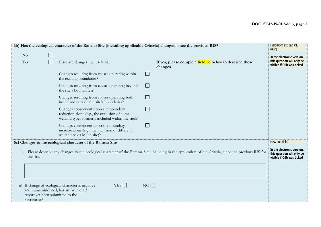
6b) Has the ecological character of the Ramsar Site (including applicable Criteria) changed since the previous RIS?
No
Yes If so, are changes the result of: If yes, please complete field 6c below to describe these changes
Changes resulting from causes operating within the existing boundaries?
Changes resulting from causes operating beyond the site’s boundaries?
Changes resulting from causes operating both inside and outside the site’s boundaries?
Changes consequent upon site boundary reduction alone (e.g., the exclusion of some wetland types formerly included within the site)?
Changes consequent upon site boundary increase alone (e.g., the inclusion of different wetland types in the site)?
Field from existing RIS (#6b) In the electronic version, this question will only be visible if Q5b was ticked
6c) Changes to the ecological character of the Ramsar Site
i) Please describe any changes to the ecological character of the Ramsar Site, including in the application of the Criteria, since the previous RIS for the site.
ii) If change of ecological character is negative
and human-induced, has an Article 3.2 report yet been submitted to the Secretariat?
YES NO
New sub-field In the electronic version, this question will only be visible if Q5b was ticked
DOC. SC42-19-01 Add.3, page 9
Part 1.2 About the site’s location
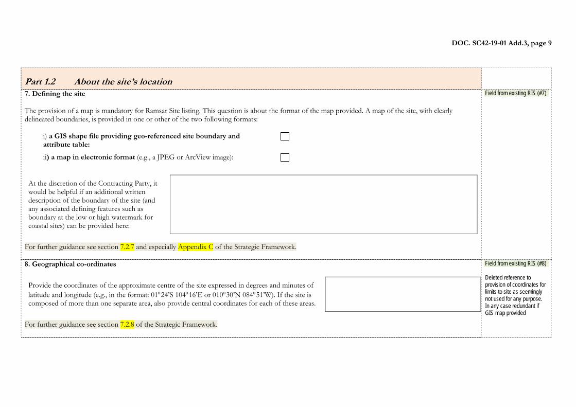
7. Defining the site The provision of a map is mandatory for Ramsar Site listing. This question is about the format of the map provided. A map of the site, with clearly delineated boundaries, is provided in one or other of the two following formats:
i) a GIS shape file providing geo-referenced site boundary and attribute table:
ii) a map in electronic format (e.g., a JPEG or ArcView image):
At the discretion of the Contracting Party, it would be helpful if an additional written description of the boundary of the site (and any associated defining features such as boundary at the low or high watermark for coastal sites) can be provided here:
For further guidance see section 7.2.7 and especially Appendix C of the Strategic Framework.
Field from existing RIS (#7)
8. Geographical co-ordinates
Provide the coordinates of the approximate centre of the site expressed in degrees and minutes of latitude and longitude (e.g., in the format: 0124’S 10416’E or 01030’N 08451’W). If the site is composed of more than one separate area, also provide central coordinates for each of these areas.
For further guidance see section 7.2.8 of the Strategic Framework.
Field from existing RIS (#8) Deleted reference to provision of coordinates for limits to site as seemingly not used for any purpose. In any case redundant if GIS map provided
DOC. SC42-19-01 Add.3, page 10
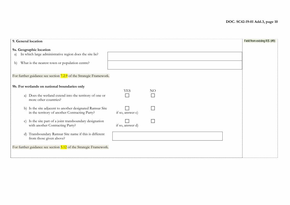
9. General location 9a. Geographic location a) In which large administrative region does the site lie?
b) What is the nearest town or population centre?
For further guidance see section 7.2.9 of the Strategic Framework.
9b. For wetlands on national boundaries only
YES NO a) Does the wetland extend into the territory of one or
more other countries?
b) Is the site adjacent to another designated Ramsar Site in the territory of another Contracting Party?
if so, answer c)
c) Is the site part of a joint transboundary designation with another Contracting Party?
if so, answer d)
d) Transboundary Ramsar Site name if this is different from those given above?
For further guidance see section 5.12 of the Strategic Framework.
Field from existing RIS (#9)
DOC. SC42-19-01 Add.3, page 11
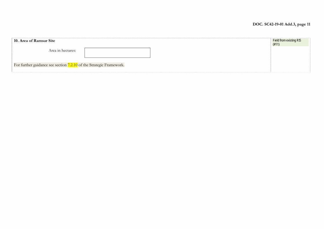
10. Area of Ramsar Site
Area in hectares:
For further guidance see section 7.2.10 of the Strategic Framework.
Field from existing RIS (#11)
DOC. SC42-19-01 Add.3, page 12
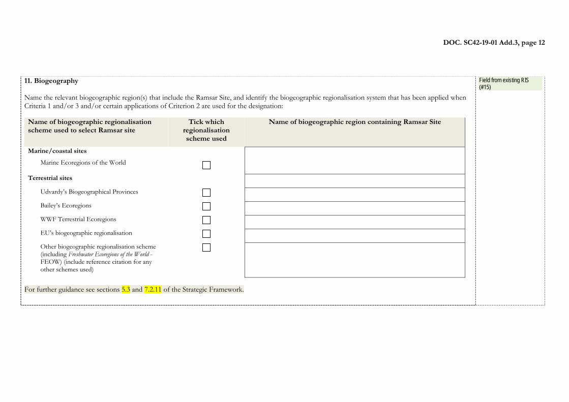
11. Biogeography Name the relevant biogeographic region(s) that include the Ramsar Site, and identify the biogeographic regionalisation system that has been applied when Criteria 1 and/or 3 and/or certain applications of Criterion 2 are used for the designation: Name of biogeographic regionalisation scheme used to select Ramsar site
Tick which regionalisation scheme used
Name of biogeographic region containing Ramsar Site
Marine/coastal sites
Marine Ecoregions of the World
Terrestrial sites Udvardy’s Biogeographical Provinces Bailey’s Ecoregions WWF Terrestrial Ecoregions EU’s biogeographic regionalisation Other biogeographic regionalisation scheme
(including Freshwater Ecoregions of the World - FEOW) (include reference citation for any other schemes used)
For further guidance see sections 5.3 and 7.2.11 of the Strategic Framework.
Field from existing RIS (#15)
DOC. SC42-19-01 Add.3, page 13
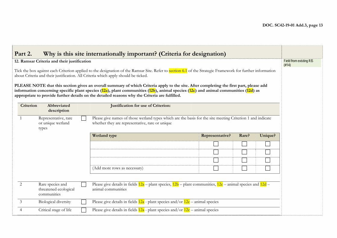
Part 2. Why is this site internationally important? (Criteria for designation) 12. Ramsar Criteria and their justification Tick the box against each Criterion applied to the designation of the Ramsar Site. Refer to section 6.1 of the Strategic Framework for further information about Criteria and their justification. All Criteria which apply should be ticked. PLEASE NOTE that this section gives an overall summary of which Criteria apply to the site. After completing the first part, please add information concerning specific plant species (12a), plant communities (12b), animal species (12c) and animal communities (12d) as appropriate to provide further details on the detailed reasons why the Criteria are fulfilled.
Criterion Abbreviated description
Justification for use of Criterion:
1 Representative, rare or unique wetland types
Please give names of those wetland types which are the basis for the site meeting Criterion 1 and indicate whether they are representative, rare or unique
Wetland type Representative? Rare? Unique?
(Add more rows as necessary) 2 Rare species and
threatened ecological communities
Please give details in fields 12a – plant species, 12b – plant communities, 12c – animal species and 12d – animal communities
3 Biological diversity Please give details in fields 12a - plant species and/or 12c – animal species
4 Critical stage of life Please give details in fields 12a - plant species and/or 12c – animal species
Field from existing RIS (#14)
DOC. SC42-19-01 Add.3, page 14
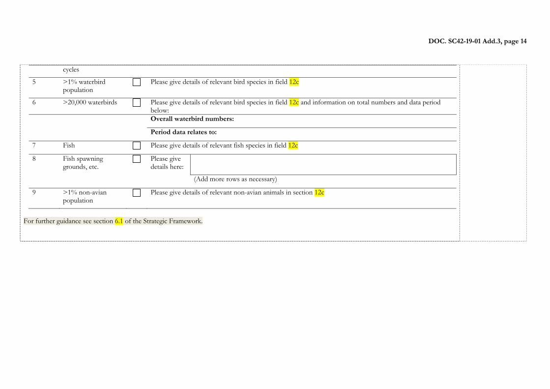
cycles
5 >1% waterbird population
Please give details of relevant bird species in field 12c
6 >20,000 waterbirds Please give details of relevant bird species in field 12c and information on total numbers and data period below:
Overall waterbird numbers:
Period data relates to:
7 Fish Please give details of relevant fish species in field 12c
8 Fish spawning grounds, etc.
Please give details here:
(Add more rows as necessary)
9 >1% non-avian population
Please give details of relevant non-avian animals in section 12c
For further guidance see section 6.1 of the Strategic Framework.
DOC. SC42-19-01 Add.3, page 15
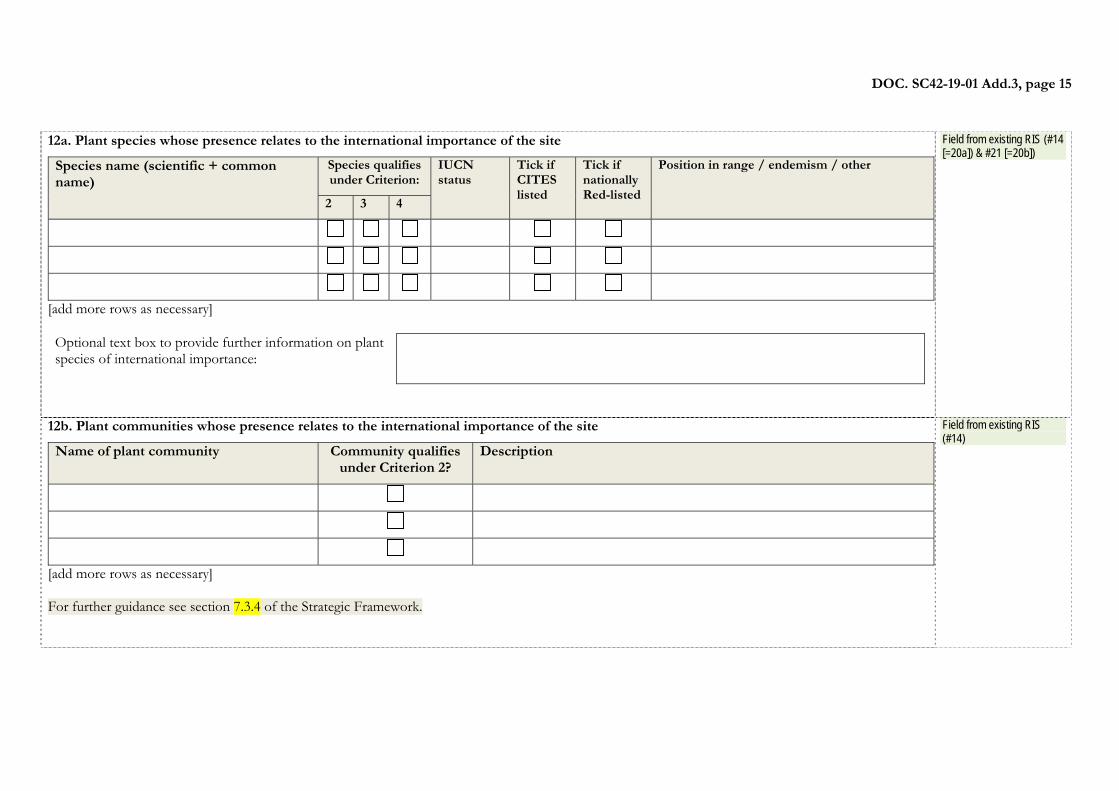
12a. Plant species whose presence relates to the international importance of the site
Species name (scientific + common name)
Species qualifies under Criterion:
IUCN status
Tick if CITES listed
Tick if nationally Red-listed
Position in range / endemism / other
2 3 4
[add more rows as necessary] Optional text box to provide further information on plant species of international importance:
Field from existing RIS (#14 [=20a]) & #21 [=20b])
12b. Plant communities whose presence relates to the international importance of the site
Name of plant community Community qualifies under Criterion 2?
Description
[add more rows as necessary] For further guidance see section 7.3.4 of the Strategic Framework.
Field from existing RIS (#14)
DOC. SC42-19-01 Add.3, page 16
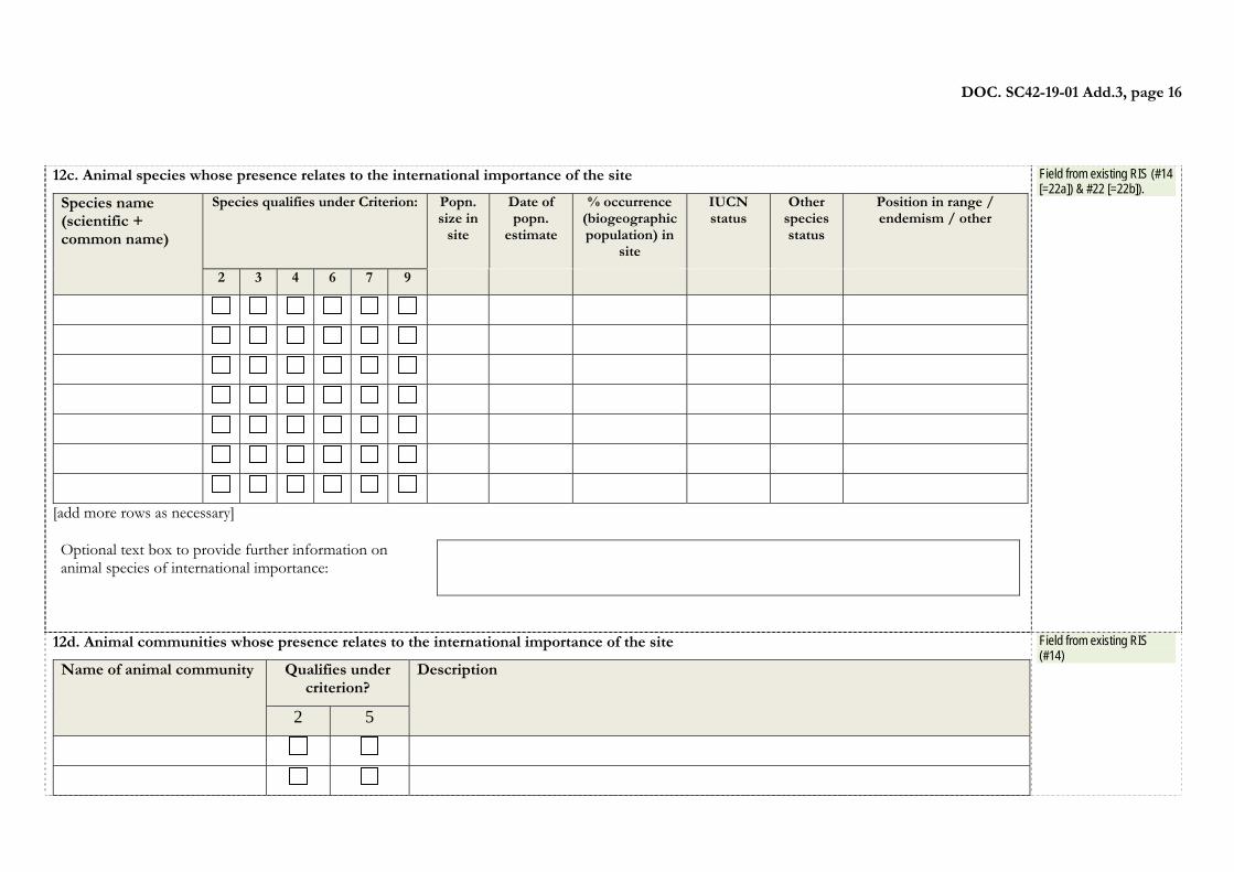
12c. Animal species whose presence relates to the international importance of the site
Species name (scientific + common name)
Species qualifies under Criterion: Popn. size in
site
Date of popn.
estimate
% occurrence (biogeographic population) in
site
IUCN status
Other species status
Position in range / endemism / other
2 3 4 6 7 9
[add more rows as necessary] Optional text box to provide further information on animal species of international importance:
Field from existing RIS (#14 [=22a]) & #22 [=22b]).
12d. Animal communities whose presence relates to the international importance of the site
Name of animal community Qualifies under criterion?
Description
2 5
Field from existing RIS (#14)
DOC. SC42-19-01 Add.3, page 17
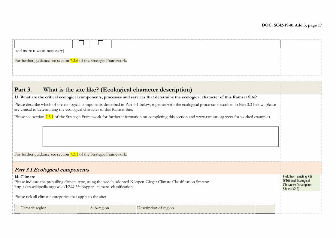
[add more rows as necessary] For further guidance see section 7.3.6 of the Strategic Framework.
Part 3. What is the site like? (Ecological character description)
13. What are the critical ecological components, processes and services that determine the ecological character of this Ramsar Site?
Please describe which of the ecological components described in Part 3.1 below, together with the ecological processes described in Part 3.3 below, please are critical to determining the ecological character of this Ramsar Site.
Please see section 7.3.1 of the Strategic Framework for further information on completing this section and www.ramsar.org.xxxx for worked examples.
For further guidance see section 7.3.1 of the Strategic Framework.
Part 3.1 Ecological components
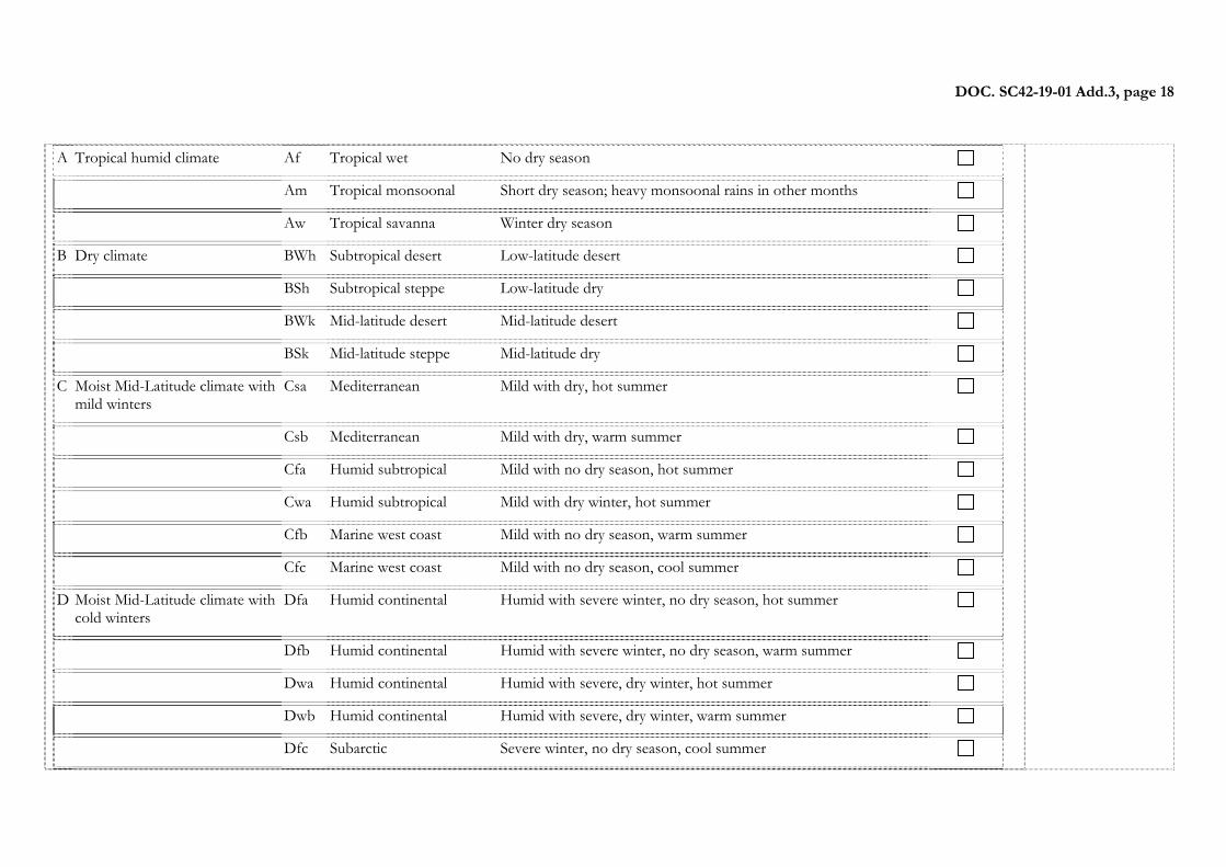
14. Climate Please indicate the prevailing climate type, using the widely adopted Köppen-Gieger Climate Classification System: http://en.wikipedia.org/wiki/K%C3%B6ppen_climate_classification. Please tick all climatic categories that apply to the site:
Climatic region Sub-region Description of region
Field from existing RIS (#16) and Ecological Character Description Sheet (#2.2)
DOC. SC42-19-01 Add.3, page 18
A Tropical humid climate Af Tropical wet No dry season
Am Tropical monsoonal Short dry season; heavy monsoonal rains in other months
Aw Tropical savanna Winter dry season
B Dry climate BWh Subtropical desert Low-latitude desert
BSh Subtropical steppe Low-latitude dry
BWk Mid-latitude desert Mid-latitude desert
BSk Mid-latitude steppe Mid-latitude dry
C Moist Mid-Latitude climate with mild winters
Csa Mediterranean Mild with dry, hot summer
Csb Mediterranean Mild with dry, warm summer
Cfa Humid subtropical Mild with no dry season, hot summer
Cwa Humid subtropical Mild with dry winter, hot summer
Cfb Marine west coast Mild with no dry season, warm summer
Cfc Marine west coast Mild with no dry season, cool summer
D Moist Mid-Latitude climate with cold winters
Dfa Humid continental Humid with severe winter, no dry season, hot summer
Dfb Humid continental Humid with severe winter, no dry season, warm summer
Dwa Humid continental Humid with severe, dry winter, hot summer
Dwb Humid continental Humid with severe, dry winter, warm summer
Dfc Subarctic Severe winter, no dry season, cool summer
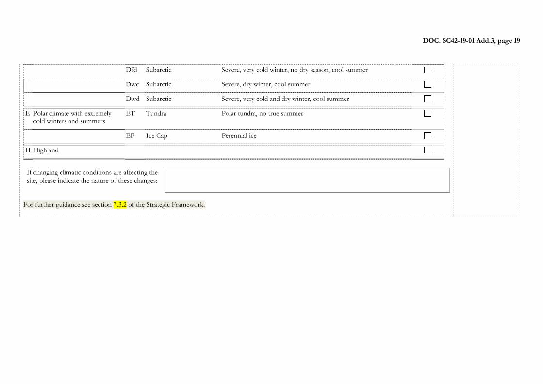
DOC. SC42-19-01 Add.3, page 19
Dfd Subarctic Severe, very cold winter, no dry season, cool summer
Dwc Subarctic Severe, dry winter, cool summer
Dwd Subarctic Severe, very cold and dry winter, cool summer
E Polar climate with extremely cold winters and summers
ET Tundra Polar tundra, no true summer
EF Ice Cap Perennial ice
H Highland
If changing climatic conditions are affecting the site, please indicate the nature of these changes:
For further guidance see section 7.3.2 of the Strategic Framework.
DOC. SC42-19-01 Add.3, page 20
15. Geomorphic setting
a) Elevation above sea level (in metres) Minimum: Maximum:
b) Position in landscape/river basin
Please tick all that apply
Entire river basin Upper part of river basin Middle part of river basin Lower part of river basin More than one river basin Not in river basin Coastal Other If ‘Other’, give type of river basin:
Name of river basin as appropriate. (For wholly coastal/ marine sites please give name of sea/ocean. If the site lies in a sub-basin then also provide the larger river basin name):
For further guidance see section 7.3.3 of the Strategic Framework.
Field from existing RIS (#10 & #17)
DOC. SC42-19-01 Add.3, page 21
16. What wetland type(s) are in the site? Please indicate either:
a) the presence of all the wetland types which occur on the site in column a); or
b) if possible, those wetlands which cover the greatest extent of the total area of the site ranked from 1 (greatest extent) to 4, in column b); or
c) if measurements are available, the area (in hectares) of each wetland type present, in column c).
For further guidance see section 5.2.2 of the Strategic Framework.
Wetland types Code and name of wetland
type a)
Wetland types present?
b)Ranking of
extent of wetland types
present (give ranks 1 [= greatest extent] to 4
only)
c)Area (ha) of wetland type
if known
Marine or coastal wetlands
Saline water Permanent A: Permanent shallow marine waters
Underwater vegetation B: Marine subtidal aquatic beds
Coral reefs C: Coral reefs
Shores Rocky D: Rocky marine shores
Sand, shingle or pebble E: Sand, shingle or pebble shores
Saline or brackish water Intertidal Flats (mud, sand or salt) G: Intertidal mud, sand or salt flats
Bivalve (shell-fish) reefs Ga: Bivalve (shell-fish) reefs
Field from existing RIS (#19). This section should adequately also address ECD #2.3 “Habitat types (including comments on particular rarity, etc.) and Ramsar wetland types”
DOC. SC42-19-01 Add.3, page 22
Marshes H: Intertidal marshes
Forested I: Intertidal forested wetlands Lagoons J: Coastal brackish/ saline
lagoons Estuarine waters F: Estuarine waters
Saline, brackish or fresh water
Subterranean Zk(a): Karst and other subterranean hydrological systems
Fresh water Lagoons K: Coastal freshwater lagoons Inland wetlands
Fresh water Flowing water Permanent Rivers, streams, creeks
M: Permanent rivers/ streams/ creeks
Deltas L: Permanent inland deltas
Springs, oases Y: Freshwater springs; oases Seasonal/ intermittent
Rivers, streams, creeks
N: Seasonal/ intermittent/ irregular rivers/ streams/ creeks
Lakes and pools Permanent > or = 8 ha O: Permanent freshwater lakes
< 8 ha Tp: Permanent freshwater marshes/ pools
Seasonal/ intermittent
> or = 8 ha P: Seasonal/ intermittent freshwater lakes
< 8 ha Ts: Seasonal/ intermittent freshwater marshes/ pools on inorganic soils
Marshes on inorganic soils
Permanent Herb-dominated Tp: Permanent freshwater marshes/ pools
Permanent/ seasonal/ intermittent
Shrub-dominated W: Shrub-dominated wetlands Tree-dominated Xf: Freshwater, tree-
dominated wetlands Seasonal/ intermittent
Herb-dominated Ts: Seasonal/ intermittent freshwater marshes/ pools
DOC. SC42-19-01 Add.3, page 23
on inorganic soils
Marshes on peat soils
Permanent Non-forested U: Non-forested peatlands Forested Xp: Forested peatlands
Marshes on inorganic or peat soils
High altitude (montane) Va: Montane wetlands
Tundra Vt: Tundra wetlands
Saline, brackish or alkaline water
Lakes Permanent Q: Permanent saline/ brackish/ alkaline lakes
Seasonal/ intermittent R: Seasonal/ intermittent saline/ brackish/ alkaline lakes and flats
Marshes & pools
Permanent Sp: Permanent saline/ brackish/ alkaline marshes/ pools
Seasonal/ intermittent Ss: Seasonal/ intermittent saline/ brackish/ alkaline marshes/ pools
Fresh, saline, brackish or alkaline water
Geothermal Zg: Geothermal wetlands
Subterranean Zk(b): Karst and other subterranean hydrological systems
Human-made wetlands
Aquaculture ponds 1
Ponds 2
Irrigated land 3
Seasonally flooded agricultural land 4
Salt exploitation sites 5
Water storage areas/Reservoirs 6
Excavations 7
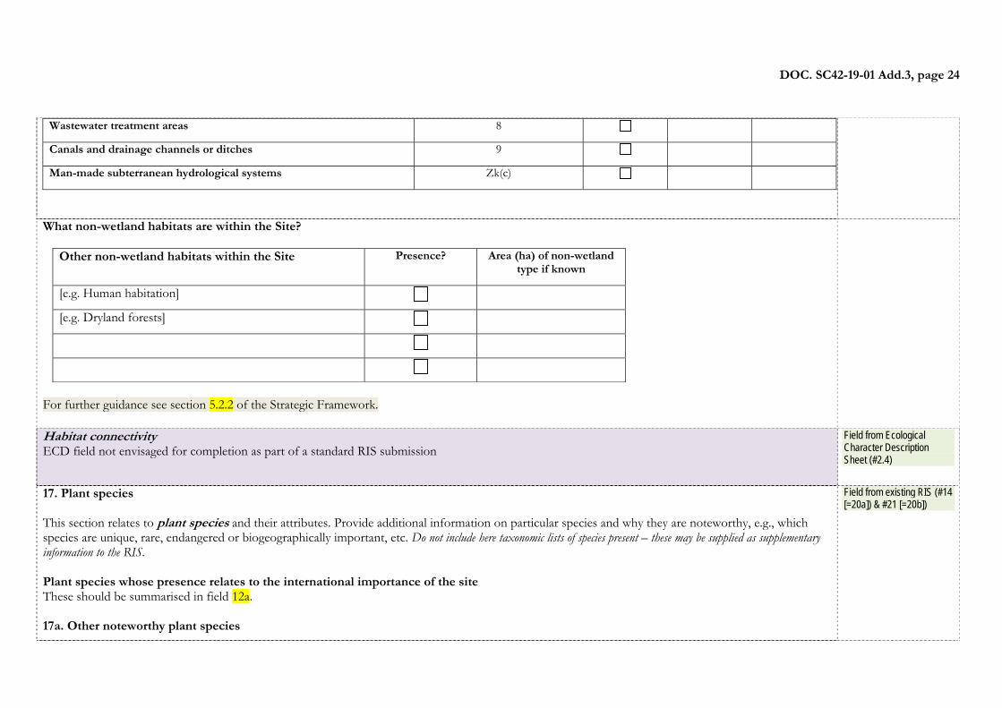
DOC. SC42-19-01 Add.3, page 24
Wastewater treatment areas 8
Canals and drainage channels or ditches 9
Man-made subterranean hydrological systems Zk(c)
What non-wetland habitats are within the Site?
Other non-wetland habitats within the Site Presence? Area (ha) of non-wetland type if known
[e.g. Human habitation] [e.g. Dryland forests]
For further guidance see section 5.2.2 of the Strategic Framework.
Habitat connectivity ECD field not envisaged for completion as part of a standard RIS submission
Field from Ecological Character Description Sheet (#2.4)
17. Plant species This section relates to plant species and their attributes. Provide additional information on particular species and why they are noteworthy, e.g., which species are unique, rare, endangered or biogeographically important, etc. Do not include here taxonomic lists of species present – these may be supplied as supplementary information to the RIS. Plant species whose presence relates to the international importance of the site These should be summarised in field 12a. 17a. Other noteworthy plant species
Field from existing RIS (#14 [=20a]) & #21 [=20b])
DOC. SC42-19-01 Add.3, page 25
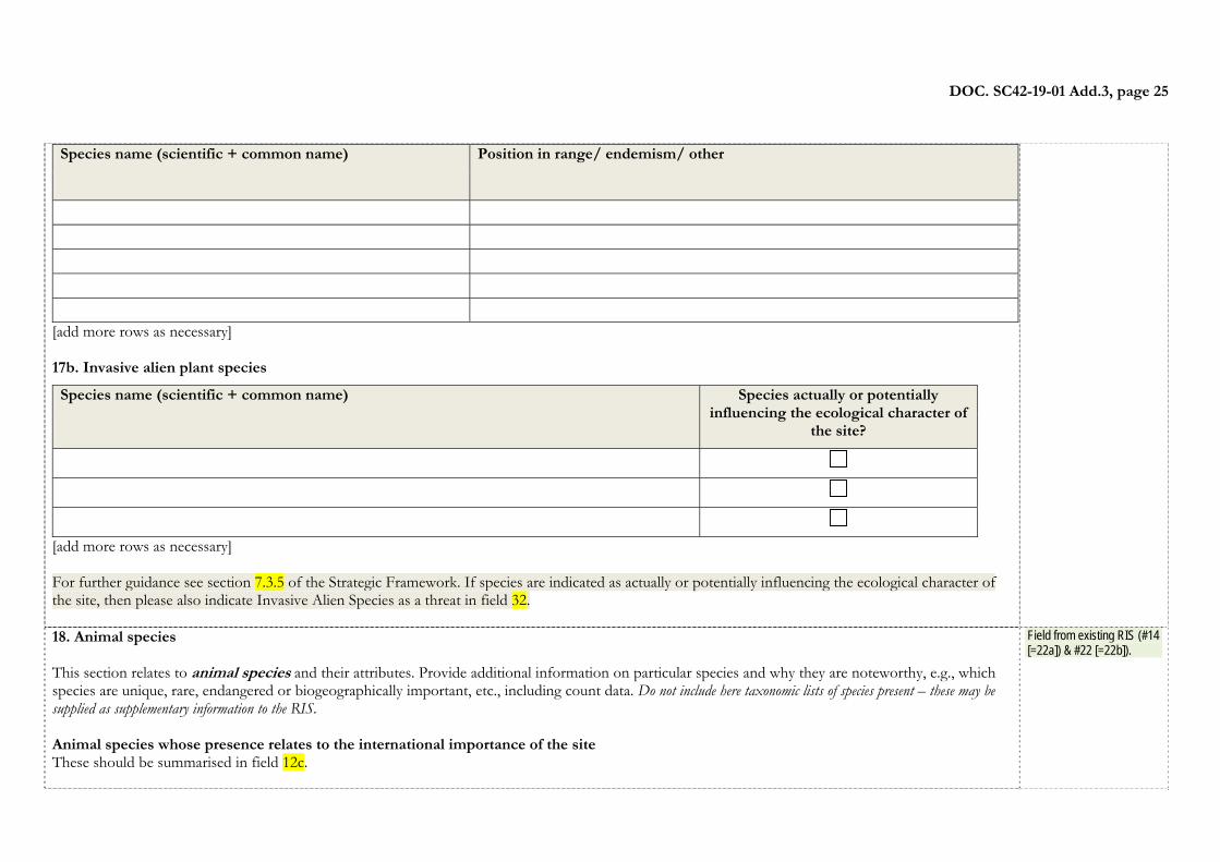
Species name (scientific + common name) Position in range/ endemism/ other
[add more rows as necessary] 17b. Invasive alien plant species
Species name (scientific + common name) Species actually or potentially influencing the ecological character of
the site?
[add more rows as necessary] For further guidance see section 7.3.5 of the Strategic Framework. If species are indicated as actually or potentially influencing the ecological character of the site, then please also indicate Invasive Alien Species as a threat in field 32. 18. Animal species This section relates to animal species and their attributes. Provide additional information on particular species and why they are noteworthy, e.g., which species are unique, rare, endangered or biogeographically important, etc., including count data. Do not include here taxonomic lists of species present – these may be supplied as supplementary information to the RIS. Animal species whose presence relates to the international importance of the site These should be summarised in field 12c.
Field from existing RIS (#14 [=22a]) & #22 [=22b]).

DOC. SC42-19-01 Add.3, page 26
18a. Other noteworthy animal species
Species name (scientific + common name)
Popn. size in site
Date of population estimate
% occurrence (biogeographic population)
Position in range / endemism / other
[add more rows as necessary] 18b. Invasive alien animal species
Species name (scientific + common name) Species actually or potentially influencing the ecological
character of the site?
[add more rows as necessary] For further guidance see section 7.3.7 of the Strategic Framework. If species are indicated as actually or potentially influencing the ecological character of the site, then please also indicate Invasive Alien Species as a threat in field 30. 19. Soil Please tick categories that apply:
Field from Ecological Character Description Sheet (#2.9)
DOC. SC42-19-01 Add.3, page 27
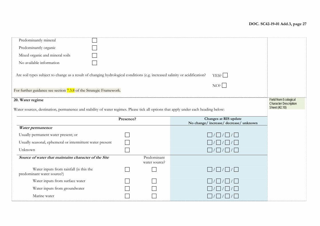
Predominantly mineral
Predominantly organic
Mixed organic and mineral soils
No available information Are soil types subject to change as a result of changing hydrological conditions (e.g. increased salinity or acidification? YES?
NO?
For further guidance see section 7.3.8 of the Strategic Framework. 20. Water regime Water sources, destination, permanence and stability of water regimes. Please tick all options that apply under each heading below:
Presence? Changes at RIS updateNo change/ increase/ decrease/ unknown
Water permanence
Usually permanent water present; or / / / Usually seasonal, ephemeral or intermittent water present / / / Unknown / / / Source of water that maintains character of the Site Predominant
water source?
Water inputs from rainfall (is this the predominant water source?)
/ / /
Water inputs from surface water / / / Water inputs from groundwater / / / Marine water / / /
Field from Ecological Character Description Sheet (#2.10)
DOC. SC42-19-01 Add.3, page 28
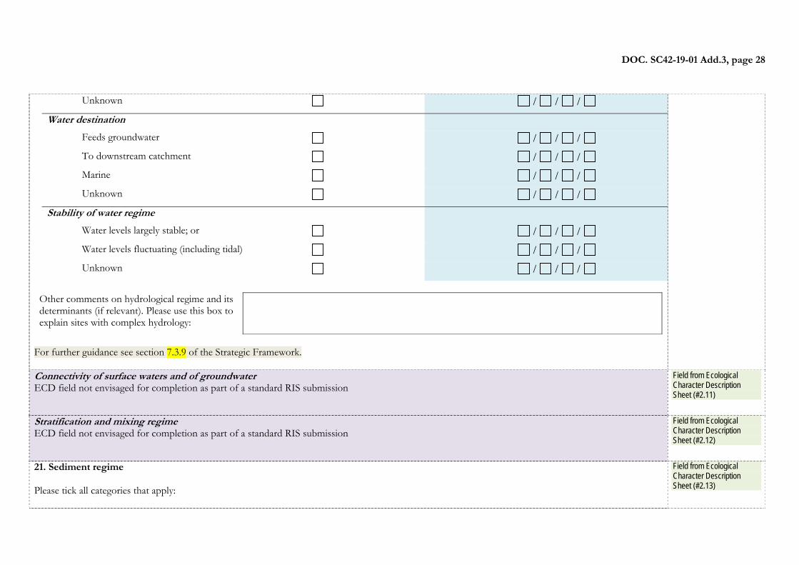
Unknown / / / Water destination Feeds groundwater / / / To downstream catchment / / / Marine / / / Unknown / / / Stability of water regime Water levels largely stable; or / / / Water levels fluctuating (including tidal) / / / Unknown / / /
Other comments on hydrological regime and its determinants (if relevant). Please use this box to explain sites with complex hydrology:
For further guidance see section 7.3.9 of the Strategic Framework. Connectivity of surface waters and of groundwater ECD field not envisaged for completion as part of a standard RIS submission
Field from Ecological Character Description Sheet (#2.11)
Stratification and mixing regime ECD field not envisaged for completion as part of a standard RIS submission
Field from Ecological Character Description Sheet (#2.12)
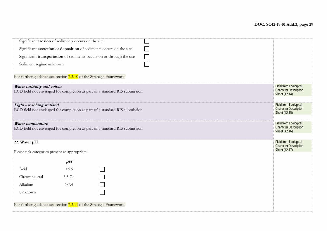
21. Sediment regime Please tick all categories that apply:
Field from Ecological Character Description Sheet (#2.13)
DOC. SC42-19-01 Add.3, page 29
Significant erosion of sediments occurs on the site
Significant accretion or deposition of sediments occurs on the site
Significant transportation of sediments occurs on or through the site
Sediment regime unknown
For further guidance see section 7.3.10 of the Strategic Framework. Water turbidity and colour ECD field not envisaged for completion as part of a standard RIS submission
Field from Ecological Character Description Sheet (#2.14)
Light - reaching wetland ECD field not envisaged for completion as part of a standard RIS submission
Field from Ecological Character Description Sheet (#2.15)
Water temperature ECD field not envisaged for completion as part of a standard RIS submission
Field from Ecological Character Description Sheet (#2.16)
22. Water pH Please tick categories present as appropriate:
pH Acid <5.5
Circumneutral 5.5-7.4
Alkaline >7.4
Unknown
For further guidance see section 7.3.11 of the Strategic Framework.
Field from Ecological Character Description Sheet (#2.17)
DOC. SC42-19-01 Add.3, page 30
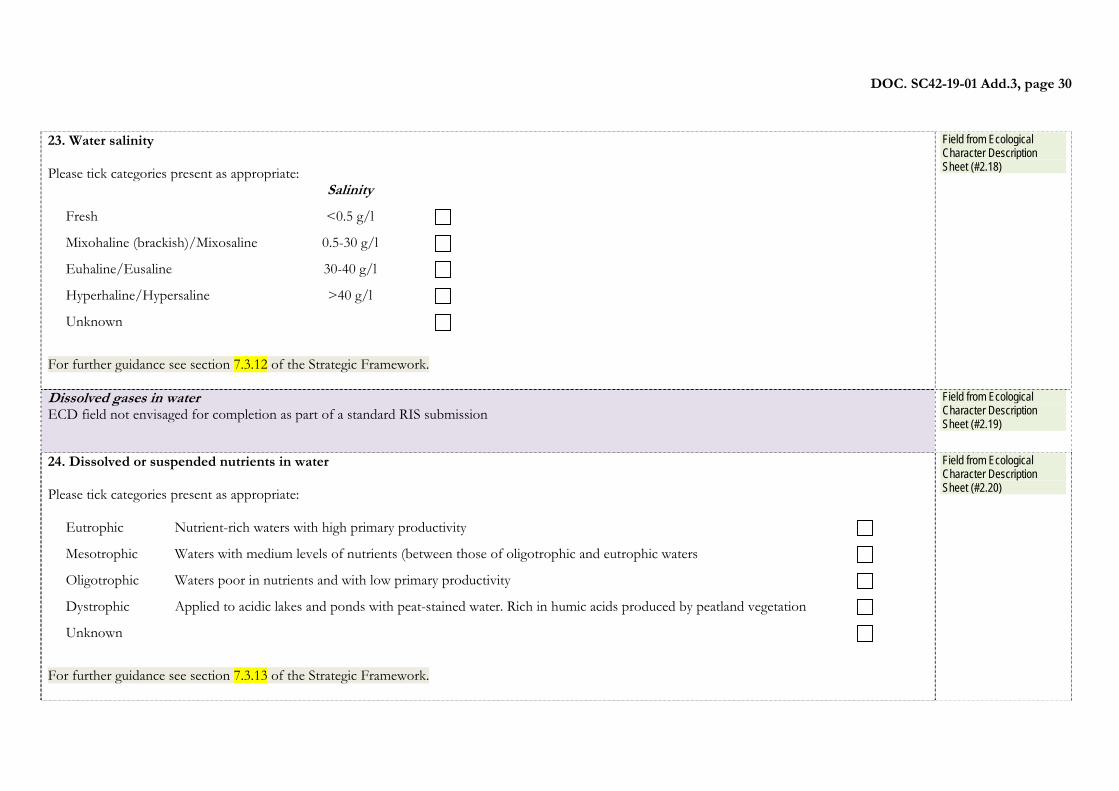
23. Water salinity Please tick categories present as appropriate:
Salinity Fresh <0.5 g/l
Mixohaline (brackish)/Mixosaline 0.5-30 g/l
Euhaline/Eusaline 30-40 g/l
Hyperhaline/Hypersaline >40 g/l
Unknown For further guidance see section 7.3.12 of the Strategic Framework.
Field from Ecological Character Description Sheet (#2.18)
Dissolved gases in water ECD field not envisaged for completion as part of a standard RIS submission
Field from Ecological Character Description Sheet (#2.19)
24. Dissolved or suspended nutrients in water Please tick categories present as appropriate:
Eutrophic Nutrient-rich waters with high primary productivity
Mesotrophic Waters with medium levels of nutrients (between those of oligotrophic and eutrophic waters
Oligotrophic Waters poor in nutrients and with low primary productivity
Dystrophic Applied to acidic lakes and ponds with peat-stained water. Rich in humic acids produced by peatland vegetation
Unknown For further guidance see section 7.3.13 of the Strategic Framework.
Field from Ecological Character Description Sheet (#2.20)
DOC. SC42-19-01 Add.3, page 31
Dissolved organic carbon ECD field not envisaged for completion as part of a standard RIS submission
Field from Ecological Character Description Sheet (#2.21)
Redox potential of water and sediments ECD field not envisaged for completion as part of a standard RIS submission
Field from Ecological Character Description Sheet (#2.22)
Water conductivity ECD field not envisaged for completion as part of a standard RIS submission
Field from Ecological Character Description Sheet (#2.23)
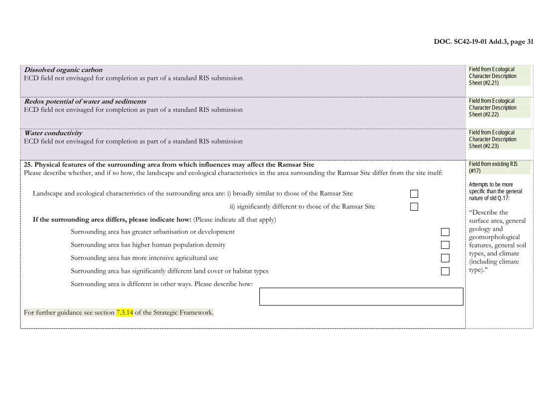
25. Physical features of the surrounding area from which influences may affect the Ramsar Site Please describe whether, and if so how, the landscape and ecological characteristics in the area surrounding the Ramsar Site differ from the site itself:
Landscape and ecological characteristics of the surrounding area are: i) broadly similar to those of the Ramsar Site ii) significantly different to those of the Ramsar Site If the surrounding area differs, please indicate how: (Please indicate all that apply)
Surrounding area has greater urbanisation or development
Surrounding area has higher human population density Surrounding area has more intensive agricultural use
Surrounding area has significantly different land cover or habitat types
Surrounding area is different in other ways. Please describe how:
For further guidance see section 7.3.14 of the Strategic Framework.
Field from existing RIS (#17) Attempts to be more specific than the general nature of old Q.17: “Describe the surface area, general geology and geomorphological features, general soil types, and climate (including climate type).”
DOC. SC42-19-01 Add.3, page 32
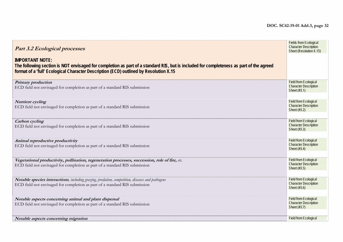
Part 3.2 Ecological processes IMPORTANT NOTE: The following section is NOT envisaged for completion as part of a standard RIS, but is included for completeness as part of the agreed format of a ‘full’ Ecological Character Description (ECD) outlined by Resolution X.15
Fields from Ecological Character Description Sheet (Resolution X.15)
Primary production ECD field not envisaged for completion as part of a standard RIS submission
Field from Ecological Character Description Sheet (#3.1)
Nutrient cycling ECD field not envisaged for completion as part of a standard RIS submission
Field from Ecological Character Description Sheet (#3.2)
Carbon cycling ECD field not envisaged for completion as part of a standard RIS submission
Field from Ecological Character Description Sheet (#3.3)
Animal reproductive productivity ECD field not envisaged for completion as part of a standard RIS submission
Field from Ecological Character Description Sheet (#3.4)
Vegetational productivity, pollination, regeneration processes, succession, role of fire, etc. ECD field not envisaged for completion as part of a standard RIS submission
Field from Ecological Character Description Sheet (#3.5)
Notable species interactions, including grazing, predation, competition, diseases and pathogens ECD field not envisaged for completion as part of a standard RIS submission
Field from Ecological Character Description Sheet (#3.6)
Notable aspects concerning animal and plant dispersal ECD field not envisaged for completion as part of a standard RIS submission
Field from Ecological Character Description Sheet (#3.7)
Notable aspects concerning migration Field from Ecological
DOC. SC42-19-01 Add.3, page 33
ECD field not envisaged for completion as part of a standard RIS submission
Character Description Sheet (#3.8)
Pressures and trends concerning any of the above, and/or concerning ecosystem integrity ECD field not envisaged for completion as part of a standard RIS submission
Field from Ecological Character Description Sheet (#3.9)
Part 3.3 Ecosystem services
26. Ecosystem services Please indicate the presence or absence of all relevant ecosystem services currently provided by the site in column a). If it is possible to assess the relative importance of different ecosystem services, this can be scored 0-3 in column b) as follows:
0 = not relevant for site 1 = present but low importance/extent or significance 2 = present, medium importance/extent or significance 3 = present, high importance/extent or significance
Ecosystem service Examples a)
Presence/ absence of
service
b)Please score 0-3 services provided by
the site if possible
Provisioning Services – products obtained from the ecosystem such as food, fuel and fresh water Food for humans Sustenance for humans (e.g. fish, molluscs) Fresh water Drinking water for humans and/or livestock Water for irrigated agriculture Water for industry Water for energy production (hydro-electricity) Wetland products non-food products
Timber Fuel wood Peat
Field from existing RIS (#29, #30 & #31)
DOC. SC42-19-01 Add.3, page 34
Livestock fodder Reeds and fibre
Other Biochemical products Extraction of material from biota Genetic materials Medicinal products Genes for tolerance to certain conditions (e.g. salinity) Genes for resistance to plant pathogens Ornamental species (live and dead) Regulating Services – benefits obtained from the regulation of ecosystem processes such as climate regulation, water regulation and natural hazard regulation
Maintenance of hydrological regimes
Groundwater recharge and discharge
Storage and delivery of water as part of water supply systems for agriculture and industry Erosion protection Soil, sediment and nutrient retention Pollution control and detoxification
Water purification/waste treatment or dilution
Climate regulation Local climate regulation/buffering of change Regulation of greenhouse gases, temperature, precipitation and other climactic processes Biological control of pests and disease
Support of predators of agricultural pests (e.g. birds feeding on locusts)
Hazard reduction Flood control, flood storage Coastal shoreline and river bank stabilization and storm protection
Cultural Services – benefits obtained from the regulation of ecosystem proceses such as climate regulation, water regulation and natural hazard regulation
Recreation and tourism* Recreational hunting and fishing Water sports and activities Picnics, outings, touring Nature observation and nature-based tourism Spiritual and inspirational Inspiration
DOC. SC42-19-01 Add.3, page 35
Cultural heritage (historical and archaeological) Contemporary cultural significance, including for arts and creative inspiration, and
including existence values
Spiritual and religious values Aesthetic and “sense of place” values Scientific and educational* Educational activities and opportunities Important knowledge systems, and importance for research (scientific reference area or
site)
Long-term monitoring site Major scientific study site ‘Type location’ for a taxon Supporting Services – services necessary for the production of all other ecosystem services such as water cycling, nutrient cycling and habitat for biota. These services will generally have an indirect benefit to humans or a direct benefit over a long period of time. Biodiversity Supports a variety of all life forms including plants, animals and microorganisms, the
genes they contain and the ecosystems of which they form a part
Soil formation Sediment retention Accumulation of organic matter Nutrient cycling Storage, recycling, processing and acquisition of nutrients Carbon storage/sequestration
Other ecosystem service(s) not included above:
Have there been studies or assessments on the economic valuation of ecosystem services provided by this Ramsar Site?
YES NO
For further guidance see section 7.3.16 of the Strategic Framework.
27. Social or cultural values
Field from existing RIS (#23)
DOC. SC42-19-01 Add.3, page 36
Is the site considered of international importance for holding, in addition to relevant ecological values, examples of significant cultural values, whether material or non-material, linked to its origin, conservation and/or ecological functioning? If so, please describe this importance under one or more of the following categories:
Type of social or cultural importance Applicable? Description if applicable
i) sites which provide a model of wetland wise use, demonstrating the application of traditional knowledge and methods of management and use that maintain the ecological character of the wetland
ii) sites which have exceptional cultural traditions or records of former civilizations that have influenced the ecological character of the wetland
iii) sites where the ecological character of the wetland depends on the interaction with local communities or indigenous peoples
iv) sites where relevant non-material values such as sacred sites are present and their existence is strongly linked with the maintenance of the ecological character of the wetland
For further guidance see section 7.3.17 of the Strategic Framework.
Part 4. How is the site managed? (Conservation and management)
Part 4.1 Land tenure and responsibilities (‘Managers’)
28. Land tenure/ownership Please indicate all relevant categories that apply to the site:
Field from existing RIS (#24)
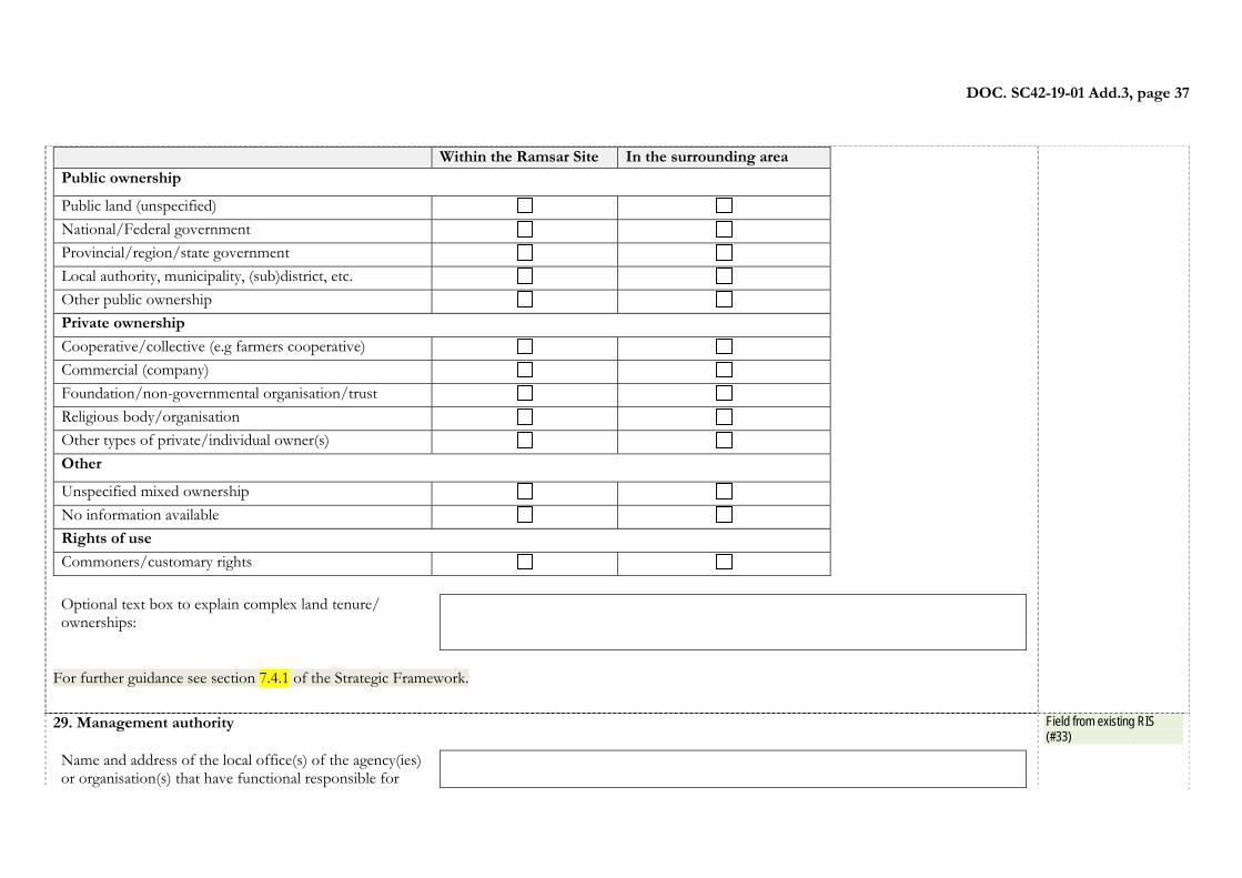
DOC. SC42-19-01 Add.3, page 37
Within the Ramsar Site In the surrounding areaPublic ownership
Public land (unspecified) National/Federal government Provincial/region/state government Local authority, municipality, (sub)district, etc. Other public ownership Private ownership
Cooperative/collective (e.g farmers cooperative) Commercial (company) Foundation/non-governmental organisation/trust Religious body/organisation Other types of private/individual owner(s) Other
Unspecified mixed ownership No information available Rights of use Commoners/customary rights
Optional text box to explain complex land tenure/ ownerships:
For further guidance see section 7.4.1 of the Strategic Framework.
29. Management authority Name and address of the local office(s) of the agency(ies) or organisation(s) that have functional responsible for
Field from existing RIS (#33)
DOC. SC42-19-01 Add.3, page 38
oversight of the site’s management: Title and/or name of the person or persons in this office with responsibility for the wetland:
Postal address:
e-mail address:
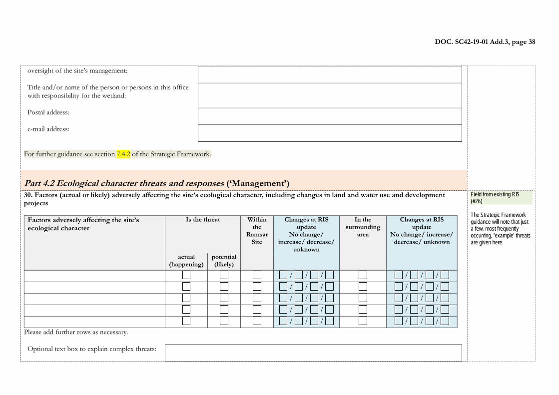
For further guidance see section 7.4.2 of the Strategic Framework.
Part 4.2 Ecological character threats and responses (‘Management’)
30. Factors (actual or likely) adversely affecting the site’s ecological character, including changes in land and water use and development projects
Factors adversely affecting the site’s ecological character
Is the threat Within the
Ramsar Site
Changes at RIS update
No change/ increase/ decrease/
unknown
In the surrounding
area
Changes at RIS update
No change/ increase/ decrease/ unknown
actual
(happening)potential (likely)
/ / / / / / / / / / / / / / / / / / / / / / / / / / / / / /
Please add further rows as necessary. Optional text box to explain complex threats:
Field from existing RIS (#26) The Strategic Framework guidance will note that just a few, most frequently occurring, ‘example’ threats are given here.
DOC. SC42-19-01 Add.3, page 39
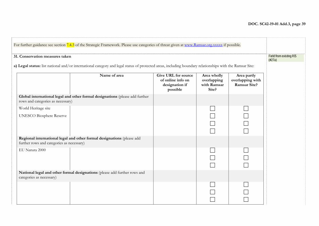
For further guidance see section 7.4.3 of the Strategic Framework. Please use categories of threat given at www.Ramsar.org.xxxxx if possible.
31. Conservation measures taken a) Legal status: list national and/or international category and legal status of protected areas, including boundary relationships with the Ramsar Site:
Name of area Give URL for source of online info on
designation if possible
Area wholly overlapping with Ramsar
Site?
Area partly overlapping with
Ramsar Site?
Global international legal and other formal designations (please add further rows and categories as necessary)
World Heritage site
UNESCO Biosphere Reserve
Regional international legal and other formal designations (please add further rows and categories as necessary)
EU Natura 2000
National legal and other formal designations (please add further rows and categories as necessary)
Field from existing RIS (#27a)
DOC. SC42-19-01 Add.3, page 40
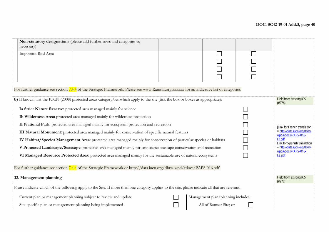
Non-statutory designations (please add further rows and categories as necessary)
Important Bird Area
For further guidance see section 7.4.4 of the Strategic Framework. Please see www.Ramsar.org.xxxxxx for an indicative list of categories. b) If known, list the IUCN (2008) protected areas category/ies which apply to the site (tick the box or boxes as appropriate):
Ia Strict Nature Reserve: protected area managed mainly for science
Ib Wilderness Area: protected area managed mainly for wilderness protection
II National Park: protected area managed mainly for ecosystem protection and recreation
III Natural Monument: protected area managed mainly for conservation of specific natural features
IV Habitat/Species Management Area: protected area managed mainly for conservation of particular species or habitats
V Protected Landscape/Seascape: protected area managed mainly for landscape/seascape conservation and recreation
VI Managed Resource Protected Area: protected area managed mainly for the sustainable use of natural ecosystems
For further guidance see section 7.4.4 of the Strategic Framework or http://data.iucn.org/dbtw-wpd/edocs/PAPS-016.pdf.
Field from existing RIS (#27b) [Link for French translation = http://data.iucn.org/dbtw-wpd/edocs/PAPS-016-Fr.pdf Link for Spanish translation = http://data.iucn.org/dbtw-wpd/edocs/PAPS-016-Es.pdf]
32. Management planning Please indicate which of the following apply to the Site. If more than one category applies to the site, please indicate all that are relevant.
Current plan or management planning subject to review and update Management plan/planning includes:
Site-specific plan or management planning being implemented All of Ramsar Site; or
Field from existing RIS (#27c)
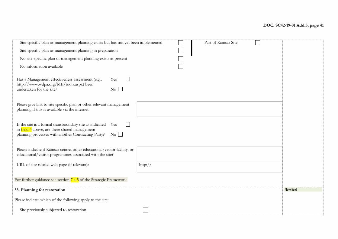
DOC. SC42-19-01 Add.3, page 41
Site-specific plan or management planning exists but has not yet been implemented Part of Ramsar Site
Site-specific plan or management planning in preparation
No site-specific plan or management planning exists at present No information available
Has a Management effectiveness assessment (e.g., http://www.wdpa.org/ME/tools.aspx) been undertaken for the site?
Yes No
Please give link to site specific plan or other relevant management planning if this is available via the internet:
If the site is a formal transboundary site as indicated in field 4 above, are there shared management planning processes with another Contracting Party?
Yes No
Please indicate if Ramsar centre, other educational/visitor facility, or educational/visitor programmes associated with the site?
URL of site-related web-page (if relevant):
http://
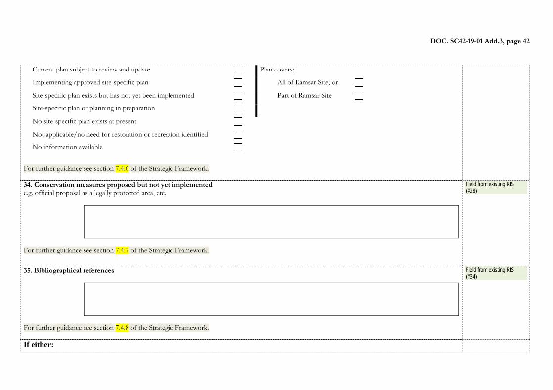
For further guidance see section 7.4.5 of the Strategic Framework. 33. Planning for restoration Please indicate which of the following apply to the site:
Site previously subjected to restoration
New field
DOC. SC42-19-01 Add.3, page 42
Current plan subject to review and update Plan covers:
Implementing approved site-specific plan All of Ramsar Site; or
Site-specific plan exists but has not yet been implemented Part of Ramsar Site
Site-specific plan or planning in preparation
No site-specific plan exists at present Not applicable/no need for restoration or recreation identified No information available
For further guidance see section 7.4.6 of the Strategic Framework. 34. Conservation measures proposed but not yet implemented e.g. official proposal as a legally protected area, etc.
For further guidance see section 7.4.7 of the Strategic Framework.
Field from existing RIS (#28)
35. Bibliographical references
For further guidance see section 7.4.8 of the Strategic Framework.
Field from existing RIS (#34)
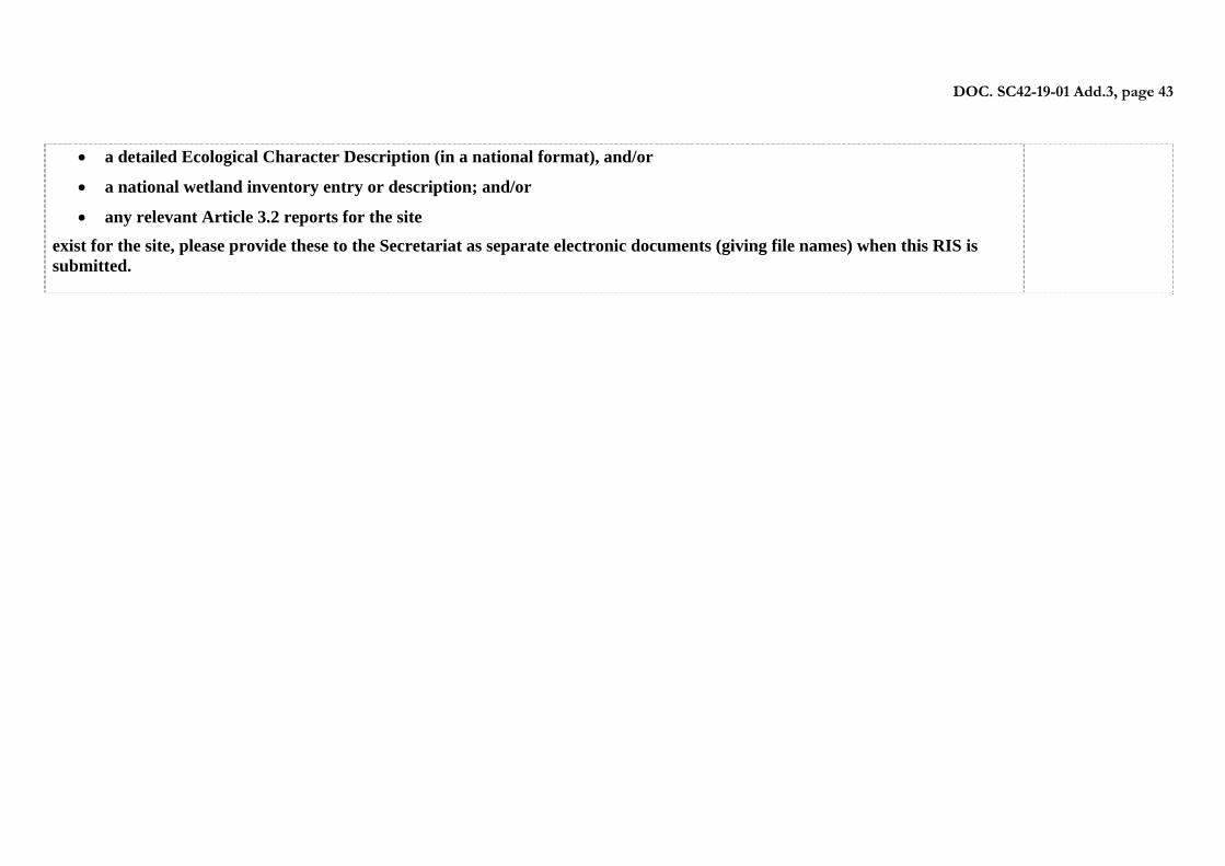
If either:
DOC. SC42-19-01 Add.3, page 43
a detailed Ecological Character Description (in a national format), and/or
a national wetland inventory entry or description; and/or
any relevant Article 3.2 reports for the site
exist for the site, please provide these to the Secretariat as separate electronic documents (giving file names) when this RIS is submitted.