REVERSE STEPTOES IN LLANCANELO VOLCANIC … STEPTOES IN LLANCANELO VOLCANIC FIELD,...
7
Lanmag Leers, Volume 3, Special Issue (2013), OB11, 1-7. Proceedings Montevideo, Uruguay OB11 - 1/7 REVERSE STEPTOES IN LLANCANELO VOLCANIC FIELD, MENDOZA- ARGENTINA: GEOLOGICAL AND GEOPHYSICAL EVIDENCES C. Prezzi 1 , C. Risso 2 , M. J. Orgeira 3 , F. Nullo 4 , L. Margonari 1 , K. Németh 5 1 Department of Geology-FCEN-FI-University of Buenos Aires-CONICET 2 Department of Geology-FCEN-University of Buenos Aires 3 Department of Geology-FCEN-University of Buenos Aires-CONICET 4 Newphoenix SRL 5 Massey University, CS-IAE, Volcanic Risk Solutions, New Zealand ABSTRACT In this paper we analyze what happens in a sector of the Llancanelo Volcanic Field where there are “circular patterns”/steptoes with the ages in reverse, i.e. the surrounding lava flow is older than the inland pyroclastic cone. The geophysical-geological studies carried out, support the proposed model for the formation of the “circular patterns” that sorround some newly scoria cones located along lineaments in the Llancanelo Volcanic Field, Mendoza, Argentina. Such “circular patterns” would have been formed by secondary fracturation of previous solidified basaltic lava flows associated to reverse dipolar magnetic anomalies, due to a new ascent and degassing of magma. The younger scoria cones (i.e., Las Bombas), associated to normal dipolar magnetic anomalies and negative complete Bouguer anomalies, would have been formed by such new magma ascent, in the depressions generated by the fracturation of the older basaltic lava flows. The younger scoria cones were eroded, reaching the heights and slopes observed today. This morphological modification underwent by the scoria cones allowed the formation of small sedimentary basins around them viewed as “circular patterns”. Keywords: circular pattern, scoria cones, phreatomagmatism, geophysic anomalies RESUMEN En este trabajo se analiza un sector del Campo Volcánico Llancanelo, donde se encuentran patrones circulares/”steptoes” con las edades invertidas, i.e., la colada de lava que lo rodea es más antigua que el cono piroclástico que se encuentra en el centro del patrón circular. Los estudios geológicos-geofísicos que se llevaron a cabo apoyan el modelo propuesto para la formación de los patrones circulares que rodean a algunos conos de escoria recientemente formados a lo largo de lineamientos en el Campo Volcánico Llancanelo, Mendoza, Argentina. Dichos patrones circulares se habrían formado por fracturación secundaria de flujos de lava previamente solidificados, asociados a anomalías magnéticas dipolares reversas, debido a un nuevo ascenso y desgasificación de magma. Los conos de escoria más jóvenes (i.e., Las Bombas), asociados a anomalías magnéticas dipolares normales y anomalías de Bouguer completas negativas, se habrían formado por el ascenso del nuevo magma, en las depresiones generadas por la fracturación de los flujos de lava más antiguos. Los conos de escoria más jóvenes fueron erosionados, alcanzando las alturas y pendientes observadas hoy en día. Esta modificación morfológica sufrida por los conos de escoria permitió la formación de pequeñas cuencas sedimentarias alrededor de los mismos, vistas como patrones circulares. Palabras Clave: patrón circular, conos de escoria, freatomagmatismo, anomalías geofísicas
Transcript of REVERSE STEPTOES IN LLANCANELO VOLCANIC … STEPTOES IN LLANCANELO VOLCANIC FIELD,...

Latinmag Letters, Volume 3, Special Issue (2013), OB11, 1-7. Proceedings Montevideo, Uruguay
OB11 - 1/7
REVERSE STEPTOES IN LLANCANELO VOLCANIC FIELD, MENDOZA-ARGENTINA: GEOLOGICAL AND GEOPHYSICAL EVIDENCES
C. Prezzi1, C. Risso2, M. J. Orgeira3, F. Nullo4, L. Margonari1, K. Németh5
1 Department of Geology-FCEN-FI-University of Buenos Aires-CONICET2 Department of Geology-FCEN-University of Buenos Aires
3 Department of Geology-FCEN-University of Buenos Aires-CONICET4 Newphoenix SRL
5 Massey University, CS-IAE, Volcanic Risk Solutions, New Zealand
ABSTRACT
In this paper we analyze what happens in a sector of the Llancanelo Volcanic Field where there are “circular patterns”/steptoes with the ages in reverse, i.e. the surrounding lava flow is older than the inland pyroclastic cone.The geophysical-geological studies carried out, support the proposed model for the formation of the “circular patterns” that sorround some newly scoria cones located along lineaments in the Llancanelo Volcanic Field, Mendoza, Argentina.Such “circular patterns” would have been formed by secondary fracturation of previous solidified basaltic lava flows associated to reverse dipolar magnetic anomalies, due to a new ascent and degassing of magma. The younger scoria cones (i.e., Las Bombas), associated to normal dipolar magnetic anomalies and negative complete Bouguer anomalies, would have been formed by such new magma ascent, in the depressions generated by the fracturation of the older basaltic lava flows. The younger scoria cones were eroded, reaching the heights and slopes observed today. This morphological modification underwent by the scoria cones allowed the formation of small sedimentary basins around them viewed as “circular patterns”.
Keywords: circular pattern, scoria cones, phreatomagmatism, geophysic anomalies
RESUMEN
En este trabajo se analiza un sector del Campo Volcánico Llancanelo, donde se encuentran patrones circulares/”steptoes” con las edades invertidas, i.e., la colada de lava que lo rodea es más antigua que el cono piroclástico que se encuentra en el centro del patrón circular.Los estudios geológicos-geofísicos que se llevaron a cabo apoyan el modelo propuesto para la formación de los patrones circulares que rodean a algunos conos de escoria recientemente formados a lo largo de lineamientos en el Campo Volcánico Llancanelo, Mendoza, Argentina.Dichos patrones circulares se habrían formado por fracturación secundaria de flujos de lava previamente solidificados, asociados a anomalías magnéticas dipolares reversas, debido a un nuevo ascenso y desgasificación de magma. Los conos de escoria más jóvenes (i.e., Las Bombas), asociados a anomalías magnéticas dipolares normales y anomalías de Bouguer completas negativas, se habrían formado por el ascenso del nuevo magma, en las depresiones generadas por la fracturación de los flujos de lava más antiguos. Los conos de escoria más jóvenes fueron erosionados, alcanzando las alturas y pendientes observadas hoy en día. Esta modificación morfológica sufrida por los conos de escoria permitió la formación de pequeñas cuencas sedimentarias alrededor de los mismos, vistas como patrones circulares.
Palabras Clave: patrón circular, conos de escoria, freatomagmatismo, anomalías geofísicas
Latinmag Letters, Volume 3, Special Issue (2013),OB11, 1-7. Proceedings Montevideo, Uruguay
OB11 - 2/7
Introduction
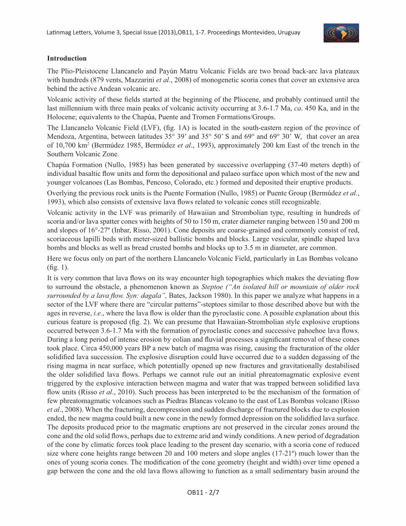
The Plio-Pleistocene Llancanelo and Payún Matru Volcanic Fields are two broad back-arc lava plateaux with hundreds (879 vents, Mazzarini et al., 2008) of monogenetic scoria cones that cover an extensive area behind the active Andean volcanic arc. Volcanic activity of these fields started at the beginning of the Pliocene, and probably continued until the last millennium with three main peaks of volcanic activity occurring at 3.6-1.7 Ma, ca. 450 Ka, and in the Holocene; equivalents to the Chapúa, Puente and Tromen Formations/Groups.The Llancanelo Volcanic Field (LVF), (fig. 1A) is located in the south-eastern region of the province of Mendoza, Argentina, between latitudes 35° 39’ and 35° 50’ S and 69° and 69° 30’ W, that cover an area of 10,700 km2 (Bermúdez 1985, Bermúdez et al., 1993), approximately 200 km East of the trench in the Southern Volcanic Zone.Chapúa Formation (Nullo, 1985) has been generated by successive overlapping (37-40 meters depth) of individual basaltic flow units and form the depositional and palaeo surface upon which most of the new and younger volcanoes (Las Bombas, Pencoso, Colorado, etc.) formed and deposited their eruptive products.Overlying the previous rock units is the Puente Formation (Nullo, 1985) or Puente Group (Bermúdez et al., 1993), which also consists of extensive lava flows related to volcanic cones still recognizable. Volcanic activity in the LVF was primarily of Hawaiian and Strombolian type, resulting in hundreds of scoria and/or lava spatter cones with heights of 50 to 150 m, crater diameter ranging between 150 and 200 m and slopes of 16°-27º (Inbar, Risso, 2001). Cone deposits are coarse-grained and commonly consist of red, scoriaceous lapilli beds with meter-sized ballistic bombs and blocks. Large vesicular, spindle shaped lava bombs and blocks as well as bread crusted bombs and blocks up to 3.5 m in diameter, are common.Here we focus only on part of the northern Llancanelo Volcanic Field, particularly in Las Bombas volcano (fig. 1).It is very common that lava flows on its way encounter high topographies which makes the deviating flow to surround the obstacle, a phenomenon known as Steptoe (“An isolated hill or mountain of older rock surrounded by a lava flow. Syn: dagala”, Bates, Jackson 1980). In this paper we analyze what happens in a sector of the LVF where there are “circular patterns”-steptoes similar to those described above but with the ages in reverse, i.e., where the lava flow is older than the pyroclastic cone. A possible explanation about this curious feature is proposed (fig. 2). We can presume that Hawaiian-Strombolian style explosive eruptions occurred between 3.6-1.7 Ma with the formation of pyroclastic cones and successive pahoehoe lava flows. During a long period of intense erosion by eolian and fluvial processes a significant removal of these cones took place. Circa 450,000 years BP a new batch of magma was rising, causing the fracturation of the older solidified lava succession. The explosive disruption could have occurred due to a sudden degassing of the rising magma in near surface, which potentially opened up new fractures and gravitationally destabilised the older solidified lava flows. Perhaps we cannot rule out an initial phreatomagmatic explosive event triggered by the explosive interaction between magma and water that was trapped between solidified lava flow units (Risso et al., 2010). Such process has been interpreted to be the mechanism of the formation of few phreatomagmatic volcanoes such as Piedras Blancas volcano to the east of Las Bombas volcano (Risso et al., 2008). When the fracturing, decompression and sudden discharge of fractured blocks due to explosion ended, the new magma could built a new cone in the newly formed depression on the solidified lava surface. The deposits produced prior to the magmatic eruptions are not preserved in the circular zones around the cone and the old solid flows, perhaps due to extreme arid and windy conditions. A new period of degradation of the cone by climatic forces took place leading to the present day scenario, with a scoria cone of reduced size where cone heights range between 20 and 100 meters and slope angles (17-21º) much lower than the ones of young scoria cones. The modification of the cone geometry (height and width) over time opened a gap between the cone and the old lava flows allowing to function as a small sedimentary basin around the
Latinmag Letters, Volume 3, Special Issue (2013), OB11, 1-7. Proceedings Montevideo, Uruguay
OB11 - 3/7
cone collecting aeolian as well as sheet wash deposits from the new cone. From the air, these depressions look circular (“circular patterns”) and surrounding relatively young scoria cones.With the aim of testing the above proposed explanation for the formation of the observed circular pattern that surrounds the Las Bombas volcano, geophysical studies were done. Detailed topographic, magnetometric and gravimetric land surveys were carried out. The analysis and interpretation of the obtained results support and are in agreement with the genetic model presented in this work.
Geophysical Studies
In order to geophysically characterize the study area and test the genetic hypothesis proposed above, we carried out detailed topographic, magnetic and gravimetric land surveys in Las Bombas volcano.
Figure 1. A: Geological map of Las Bombas volcano and surroundings in the LVF. B: WE Malargue basin stratigraphic section (out of scale)

Latinmag Letters, Volume 3, Special Issue (2013),OB11, 1-7. Proceedings Montevideo, Uruguay
OB11 - 4/7
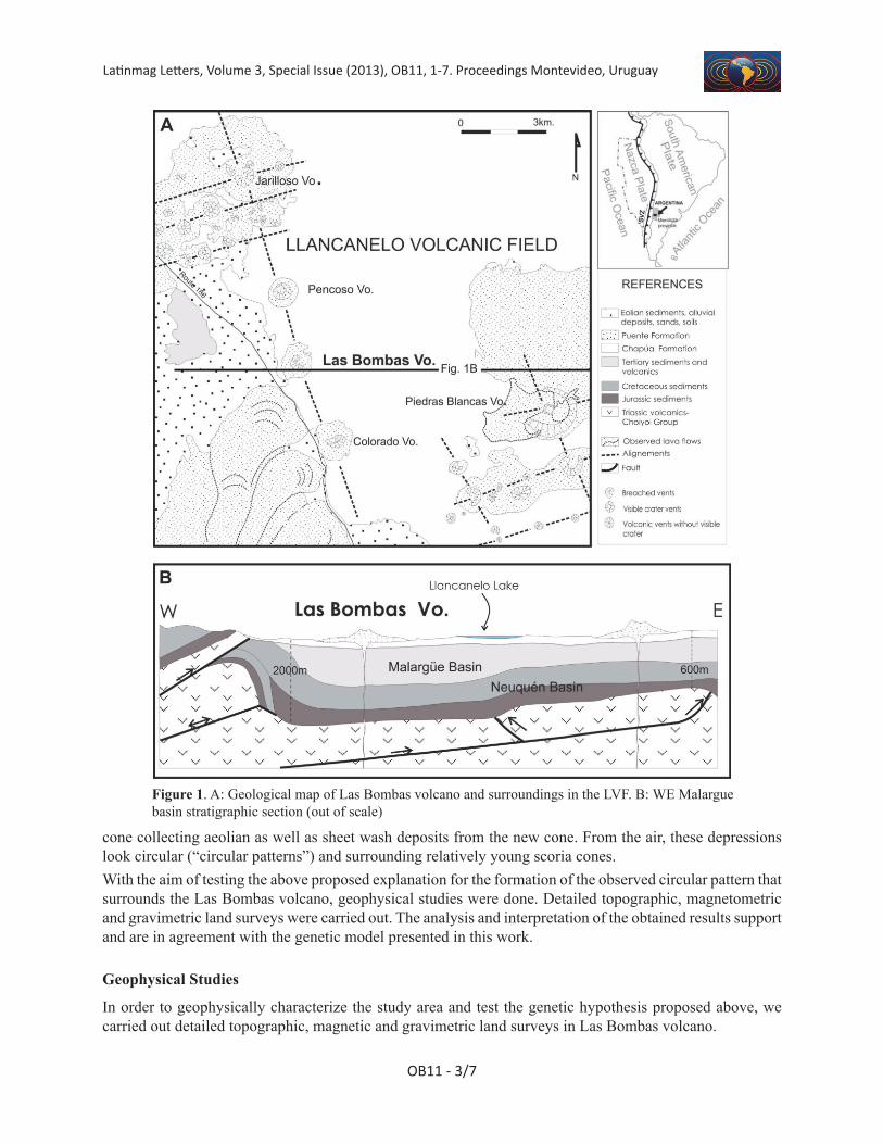
A number of 451 topographic points were surveyed with a Constructor SP 571145130 total station (fig. 3). The obtained values were gridded applying the minimum curvature algorithm. Total magnetic field was measured at 1823 stations (fig. 4), using a Geometrics 856 proton precession magnetometer with an equidistance of 10 m between stations. The obtained data were corrected for the diurnal variations in the Earth’s magnetic field and the corresponding IGRF (International Geomagnetic Reference Field) value was subtracted. Relative gravity measurements were made using a ZLS Burris Standard gravity meter in 122 stations (fig. 5), with an equidistance of 20 m and a precision of 0.01 mGal. The survey was not tied to an absolute gravity station. The geographic location of each one of the measured gravity stations was determined with
Figure 2. Geological sketch (out of scale) showing the development of the “circular pattern” during time.
Figure 3. Detailed topography surveyed in the field of Las Bombas volcano and its sorrounding “circular pattern”. Triangles: topographic stations.
Latinmag Letters, Volume 3, Special Issue (2013), OB11, 1-7. Proceedings Montevideo, Uruguay
OB11 - 5/7
the Constructor SP 571145130 total station. Current standards for reduction of observed gravity to Bouguer anomaly established by the U.S. Geological Survey (USGS) and the North American Gravity Database Committee were applied through the use of the spreadsheet for reduction of raw data to the Bouguer anomaly developed by Holom and Oldow (2007). With the additional use of solid earth tide and terrain corrections, the complete Bouguer anomaly was calculated. This spreadsheet (Holom, Oldow 2007) calculates the corrections for instrument drift, as well as the DC shift (i.e., constant value added or subtracted to observed gravity values) for multiple-day gravity surveys. To do these corrections we measured relative gravity in the same base station several times a day during the survey. The average instrument drift correction in each station was of approximately of 0.01 mGal.To calculate height and Bouguer spherical cap corrections, the height above the WGS84 reference ellipsoid for each station was measured using the Constructor SP 571145130 total station with a precision of 0.05 m. Earth tide correction was calculated with the software TSoft version 2.1.15 and entered in the spreadsheet of Holom and Oldow (2007). Finally, terrain correction was performed using as input the topographic grid obtained from the detailed topography survey and also entered in the spreadsheet of Holom and Oldow (2007). The maximum terrain correction was of 0.542 mGal, with an average value of 0.075 mGal.
Results And Discussion
The magnetic survey shows two dipolar magnetic anomalies (fig. 4). One of them corresponds to the basaltic pahoehoe flows forming the border of the circular pattern associated with Las Bombas volcano. This dipolar anomaly presents a minimum ~of −800 nT to the north of the area and a maximum ~ of 1900 nT to the south (fig. 4). Ten oriented hand samples from these basaltic flows were taken for natural remanent magnetization (NRM) intensity measurements in the laboratory, using a SQUID 2G SSR cryogenic magnetometer. The intensity of the NRM has an average value of 11378 mA/m. This intensity of the NRM would control one of the detected dipolar magnetic anomalies which is of reverse character. Such magnetic signature indicates that these basalts cooled during a period in which the polarity of the geomagnetic field was opposite to the present one. The other dipolar magnetic anomaly, located in the centre of the area, is closely associated with the scoria cone (fig. 4). It presents a maximum ~ of 2500 nT to the north and a minimum ~ of -800 nT to the south (fig. 4), being of normal polarity. This anomaly would suggest that the formation of the scoria cone occurred during a period in which the polarity of the geomagnetic field was like the present one.
Figure 4. Magnetic anomaly (nT) detected in Las Bombas volcano and its sorrounding “circular pattern”. White dots: magnetic stations. Black lines: topographic contour lines.
Latinmag Letters, Volume 3, Special Issue (2013),OB11, 1-7. Proceedings Montevideo, Uruguay
OB11 - 6/7
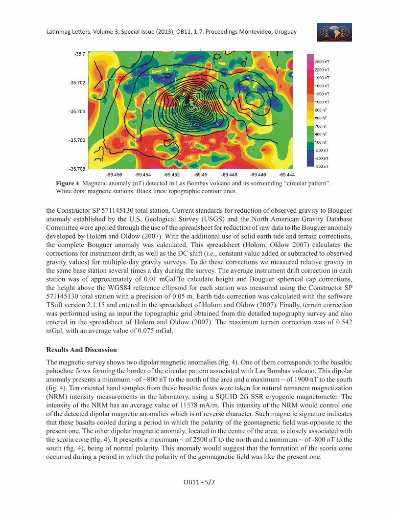
The complete Bouguer anomaly presents a minimum value of ~ -5 mGal, which correlates perfectly with the maximum height of the scoria cone (~ 50 m) (fig. 5). This negative anomaly indicates the existence of a mass deficit below the cone. Considering that all the geogical Formations described in the area correspond to basaltic flows, no density contrast due to lithological differences should be expected. Therefore, the negative anomaly could only be satisfactorily explained by means of the existence of secondary fracturation below the cone generated during the volcanic eruption.
Our results suggest that the volcanic processes in the area took place in two different events during distinct time spans. The oldest one occurred during a period in which the polarity of the geomagnetic field was opposite to the present one. The basaltic flows responsible of this reverse dipolar magnetic anomaly, which conforms the border of the studied circular pattern, were assigned to Chapúa Formation (see above; Late Pliocene to Early Pleistocene; between 3.6 to 1.7 Ma). Considering these facts, such basaltic flows could have solidified during the Matuyama chron (2.41 to 0.7 Ma) or Late Gilbert chron (older than 3.4 Ma); all the same, it should be taken into account that cooling during reverse events of the Gauss chron could not be completely ruled out. On the other hand, according to the geological observations, the youngest volcanic event associated with the formation of the scoria cone and responsible of the normal dipolar magnetic anomaly detected should have occurred during the Bruhnes chron (< 0.7 Ma). Consequently, the results of the geophysical studies carried out here agree with the explanation proposed for the formation of the observed circular pattern which sorrounds Las Bombas volcano (fig. 2).
Conclusions
The results of the geophysical studies carried out in this work, support the here proposed model for the formation of the “circular patterns” that sorround the scoria cones located along lineaments in the Llancanelo Volcanic Field, Mendoza, Argentina.Such “circular patterns” would have been formed by secondary fracturation of previous solidified basaltic lava flows associated to reverse dipolar magnetic anomalies (assigned to Chapúa Formation), due to a new ascent and degassing of magma. The younger scoria cones, associated to normal dipolar magnetic anomalies and negative complete Bouguer anomalies, would have been formed by such new magma ascent, in the depressions generated by the fracturation of the older basaltic lava flows.
Figure 5. Complete Bouguer Anomaly (mGal) detected in Las Bombas volcano and its sorrounding “circular pattern”. Triangles: gravity stations.

Latinmag Letters, Volume 3, Special Issue (2013), OB11, 1-7. Proceedings Montevideo, Uruguay
OB11 - 7/7
The younger scoria cones were eroded, reaching the heights and slopes observed today. This morphological modification underwent by the scoria cones allowed the formations of small sedimentary basins around them.
References
Bates R., Jackson J., 1980. Glossary of Geology, 2º ed. American Geological Institute.Bermúdez A., Delpino D., Frey F., Saal A.,1993, Los basaltos de retroarco extraandinos.,
In: Ramos, V. (Ed) Geología y Recursos Naturales de Mendoza - 12º Congreso GeológicoBermúdez, A., 1985. Los basaltos post-pliocenos entre los 36º y 37º de latitud, provincia de Mendoza,
Argentina., IV Congreso Geológico Chileno, Actas (Antofagasta), 3, 52-67Holom D., Oldo, D., 2007. Gravity reduction spreadsheet to calculate the Bouguer anomaly
using standardized methods and constants, Geosphere, 3(2), 86-90. doi: 10.1130/GES00060.1Inbar M., Risso C., 2001. A morphological and morphometric analysis of a high density cinder cone volcanic
field - Payún Matru, south-central Andes, Argentina, Zeitschrift für Geomorphologie, 45, 321-343Mazzarin, F, Fornaciai A., Bistacchi A., Pasquarè F., 2008. Fissural volcanism, polygenetic volcanic fields,
and crustal thickness in the Payen Volcanic Complex on the central AndesAndes foreland (Mendoza, Argentina). G3, 9(9). doi:10.1029/2008GC002037
Nullo F., 1985, Hoja Geológica Cerro Campanario 1:250.000 Unpublished Geological Map and Report, SEGEMAR, Buenos Aires.
Risso C., Nemeth K., Nullo F., Inbar M., 2010. “Circular features” on old solidified lava flow fields associated with some young scoria cones from Llancanelo and Payún Matru Volcanic Fields, Mendoza province, Argentina, Bolletino di Geofisica Teorica ed Applicata, Scientific contributions, Vol 51, 83-85.
Risso C., Nemeth K., Combina A., Nullo F., Drosina M., 2008. The role of phreatomagmatism in a Plio-Pleistocene high-density scoria cone field: Llancanelo Volcanic Field (Mendoza), Argentina. Journal of Volcanology and Geothermal Research, 169, 1-2, 61-86.