Restoration Plan-Albany Rapp Road Landfill D...J:060590:060708 5 Albany Rapp Road Landfill 3....
109
J:060590:060708 Albany Rapp Road Landfill ALBANY RAPP ROAD LANDFILL ECOSYSTEM MITIGATION, RESTORATION & ENHANCEMENT PLAN ALBANY, NEW YORK Prepared by: Applied Ecological Services, Inc. 17921 City of Albany Rd. Brodhead, WI 53520 AES Project Number 06-0590 September 2008
Transcript of Restoration Plan-Albany Rapp Road Landfill D...J:060590:060708 5 Albany Rapp Road Landfill 3....

J:060590:060708 Albany Rapp Road Landfill
ALBANY RAPP ROAD LANDFILL ECOSYSTEM MITIGATION, RESTORATION & ENHANCEMENT
PLAN
ALBANY, NEW YORK
Prepared by:
Applied Ecological Services, Inc. 17921 City of Albany Rd.
Brodhead, WI 53520 AES Project Number 06-0590
September 2008

J:060590:060708 2 Albany Rapp Road Landfill
ALBANY RAPP ROAD LANDFILL ECOSYSTEM MITIGATION, RESTORATION & ENHANCEMENT
PLAN
ALBANY, NEW YORK
1 PREFACE........................................................................................................................3 2 INTRODUCTION..........................................................................................................3 3 MITIGATION GOALS & OBJECTIVES ......................................................................5 3.1 Statement of Purpose.................................................................................................5 3.2 Ecosystem Restoration – A Background & Basis for Restoration ............................6 3.3 Potential Impacts & Mitigation .................................................................................12 3.4 Proposed Mitigation Wetlands & Restored Upland Ecosystems, Functions & Values .........................................................................................................................14 3.5 Restoration Program Summary..................................................................................18 4 COMPONENTS OF THE RESTORATION & MANAGEMENT PROGRAM.........20 4.1 Restoration & Management Philosophy ...................................................................20 4.2 Adaptive Restoration & Management .......................................................................20 4.3 Structure & Initial Implementation ...........................................................................20 4.4 Scheduling..................................................................................................................21 4.5 Ecological Monitoring ...............................................................................................21 4.6 Reporting ...................................................................................................................22 4.7 Construction Phasing.................................................................................................22 4.8 Closure Plan ...............................................................................................................22 4.9 Long-Term Management Program ...........................................................................25 ATTACHMENT 1. Plan Set .......................................................................................................26 ATTACHMENT 2. Construction Specifications .......................................................................27 ATTACHMENT 3. Monitoring Specifications ..........................................................................90

J:060590:060708 3 Albany Rapp Road Landfill
ALBANY RAPP ROAD LANDFILL ECOSYSTEM MITIGATION, RESTORATION & ENHANCEMENT
PLAN ALBANY, NEW YORK
1. PREFACE This document provides a detailed ecosystem-based restoration plan and specifications for addressing the mitigation needs for the potential impacts of the expansion of the Rapp Road Landfill adjacent to Albany Pine Bush Preserve lands and for direct, unavoidable impacts to State and federally regulated wetlands and other waters of the United States. As a member of the Albany Pine Bush Preserve Commission and a major contributor to the Commission’s funds for operation and maintenance of the Preserve, the City also recognized the opportunity to go beyond normal impact-mitigation assessments to provide enhancements to the preserve that would probably not occur without a major funding source. The Ecosystem Mitigation, Restoration & Enhancement Plan (plan, restoration plan, restoration program) is comprised of an introduction and overview narrative; a Plan Set (Attachment 1) which contains the construction drawings showing the restoration locations, grading plans, planting details, phasing, and the layout of the monitoring program; the Construction Specifications (Attachment 2) providing details on construction techniques, plant materials, management requirements for the restored landscapes, reporting requirements during construction and restoration phases; and Monitoring Specifications (Attachment 3) providing requirements and protocols for measuring the performance of the restoration program. Discussions of the existing conditions and the intended outcomes of the restoration program are also provided in the Supplemental Draft Environmental Impact Statement (SDEIS) prepared for the landfill project. We include selected information from the SDEIS in the restoration plan document, to support the restoration program details. The City of Albany (the City) acknowledges that to successfully undertake the restoration program will require a committed team and close coordination with the Albany Pine Bush Preserve Commission (APBPC, the Preserve) and staff, and other locally knowledgeable experts. The City is also committed to using the current design team or equally qualified firm to oversee and build, manage, and monitor the restoration program to successfully complete the project to the satisfaction of regulators and conservation professionals with the APBPC. 2. INTRODUCTION The proposed landfill project involves the expansion of the existing Rapp Road Landfill onto City-owned lands located east of the existing landfill (Eastern Expansion) in order to continue to meet the solid waste disposal needs of City residents and businesses as well as the communities that make up the Albany New York Solid Waste Energy Recovery System (ANSWERS) Solid Waste Management Planning Unit, and the Capital Region as a whole. ANSWERS is comprised of a consortium of communities that include the cities of Albany, Rensselaer, and Watervliet, the towns of Berne, Bethlehem, Guilderland, Knox, New Scotland, Rensselaerville, and Westerlo, and the Villages of Green Island and Altamont.

J:060590:060708 4 Albany Rapp Road Landfill
The Eastern Expansion of the landfill involves an overfill of approximately 23 acres of the existing landfill and a lateral expansion of approximately 15 acres that includes 2 acres within the existing landfill operations area (disturbed/developed lands) and 13 acres within undeveloped City-owned property directly to the northeast. Existing landfill infrastructure including offices, the recycling building, and other accessory uses will be relocated to three parcels totaling approximately 3.5 acres located directly east of the landfill entrance road off of Rapp Road. An approximately 1-acre remnant parcel of land owned by the State of New York, under the jurisdiction of the Department of Transportation, would be required to access the relocated landfill operations off of Rapp Road. Plans in Attachment 1 illustrate the general layout of the expansion. An integral part of the Eastern Expansion proposal is the restoration program. There is a significant opportunity to re-establish habitat linkages from west to east in the APBP through the existing mobile home park property and over portions of the closed landfill. Implementation of the restoration plan would be an ongoing process, beginning with wetland mitigation and stream restoration on the mobile home park property and demonstration plots on the existing landfill, and continuing with habitat restoration efforts on closed portions the existing landfill as well as surrounding areas of currently degraded habitat. It is envisioned that the landfill can be blended into the APBP landscape, providing critical habitat for rare ecological communities and threatened and endangered species. The plan is also designed to address other influences on the natural communities within the APBP. These influences include the mobile home park and the grading and sand mining that removed Pine Bush habitat and changed the landscape, the relocation and ditching of natural streams that are tributary to Lake Rensselaer, and the draining and ditching of large wetland areas for past agricultural purposes, all of which contribute to poor water quality and the loss of natural/native Pine Bush communities. The restoration program and the Eastern Expansion are intertwined in terms of construction phasing, financing, and closure. Restoration, mitigation, and enhancement projects will begin during the first year of the landfill expansion and will be phased over the anticipated 6.6-year life of the project, with the final phase a component of the closure plan. The end result converts the entire Rapp Road Landfill complex and surrounding lands, with the exception of landfill operations structures that will be needed to continue to address gas and leachate collection, odor abatement, and possible transfer station operations, into Pine Bush habitat. This expansion project provides the financial means to restore and enhance approximately 250 acres of land. With limited State and local funding sources, the ability of the APBPC to achieve the goals of the restoration program is significantly diminished if not impossible. The intent of the City is to make this win-win scenario a reality. The restoration plan is proposed in concert with the Eastern Expansion to restore and enhance pine bush ecology within degraded areas north of the landfill, to reconnect viable pine bush east and west of the mobile home park, to integrate the landfill itself back into the pine bush, to improve downstream water quality, and to compensate for the direct, unavoidable impacts to State and federally regulated wetlands and other waters of the United States.

J:060590:060708 5 Albany Rapp Road Landfill
3. MITIGATION GOALS AND OBJECTIVES 3.1 Statement of Purpose The purpose and need statement for the Rapp Road Landfill expansion is documented in the SDEIS prepared for this project and presented elsewhere. The restoration plan is prepared in recognition that the landfill is an important public facility providing an essential waste disposal service to residents, businesses, and institutions throughout the Capital Region. Because the restoration plan will ultimately result in converting the vast majority of the landfill and surrounding City properties into restored Pine Bush habitats, the timing of the continued operational needs of the landfill are important to understand. The additional capacity that will be realized by the proposed Eastern Expansion will provide the time needed to plan, site, and develop the next generation of waste management facilities for the Capital Region. At current rates of disposal, the Eastern Expansion at the Rapp Road Landfill will provide 6-7 years of landfill life. However, unlike previous expansion efforts, the option for an additional future expansion will be foreclosed due both to the fact that all surrounding lands are dedicated to the APBP and because the proposed restoration plan will be phased in during construction and operation of the expansion, with the last phase of the restoration encompassing the Eastern Expansion after closure. The result would be a landfill transformed into Pine Bush habitat with some remaining landfill infrastructure such as landfill offices, a possible future transfer station, and gas-to-energy facilities. Therefore, the majority of the landfill, as well as the surrounding lands, will be committed to habitat, leaving no room for further expansion. The plan outlines a program for restoring and managing native plant communities associated with a comprehensive package of mitigation and enhancement proposed at the Rapp Road Landfill. This document describes the restoration and management plans and the monitoring program to measure the effectiveness of the restoration program, and provides the specifications that will be used to implement the restoration plans. The plan is designed to address the following objectives:
1. Replace ecological functions and values of impacted wetland acreages in accordance with a
wetland mitigation plan; restore appropriate upland plant and animal communities in locations that are currently highly degraded upland and lowland environments, such as the trailer park and eventual closed landfill surface acreages; and improve existing degraded (tile and ditch drained hydrology) wetlands found in neighboring NYDEC properties.
2. Restore the ecology, diversity, and beauty of native plant communities in low quality existing ecosystems.
3. Create an ecologically meaningful and sizable wetland mitigation project that can serve as an important wildlife habitat area and that can link currently fragmented landscapes in and adjacent to the APBP.
4. Provide for public use and enjoyment of the expanded restored natural resource areas and open space.
With regard to objective number 3 above, Table 1 summarizes the potential impacts to wetland communities and the overall enhancement and mitigation package. The proposed Eastern Expansion will result in the unavoidable taking of 5.05 acres of disturbed wetlands (see the Supplemental Draft Environmental Impact Statement (SDEIS) for the wetland delineation and other reports that document the condition of the proposed impacted wetlands), as well as 0.56 acres of impact outside of the Landfill

J:060590:060708 6 Albany Rapp Road Landfill
Expansion area within the restoration area associated with filling an existing Phragmites-dominated ditch for construction of a biofilter wetland, and an additional 4.29 acres of wetland vegetation to be disturbed by construction grading. A total of 52.88 acres of wetland will be mitigated and enhanced, including 21.84 acres to be created (wetlands derived from disturbed/poor quality upland areas through grading, planting and other means to modify hydrology and encourage the growth of native wetland species), 4.29 acres to be restored (existing wetlands to be graded and modified to higher quality wetlands), and 26.75 acres to be enhanced (existing wetlands to be slightly modified through less invasive measures in order to eliminate invasive species and improve overall functions and values). A total of 205.85 acres of upland Pine Bush grassland and forest communities will also be enhanced as part of the restoration program. Table 1. Disturbed and Mitigation acreages for the Rapp Road Landfill Project.
Impacts Mitigation Landfill
Expansion Area
Restoration Area
Restoration Area & Landfill
Community
Acres Filled
Acres Filled
Acres Graded for
Wetland Restoration
Acres
Created
Acres
Restored
Acres
Enhanced
Degraded Wetlands Ditches/Wet Old Fields
0.38
0.72
Disturbed Forested Wetland
5.05
2.96
Subtotals 5.05 0.38 3.68 Restored Wetlands
Bog 1.04 Sedge Meadow 0.76 Forested Wetlands (Red Maple Hardwood Swamp)
19.65
2.96
27.45
Biofilter Wetland 0.69 0.72 Subtotals 22.14 3.68 27.45
Totals 5.43 3.68 53.27 Streams
Ditch (from upland) 190 lf 500 lf Ditched Stream 1,490 lf 600 lf Restored Stream 3,500
Totals 1,680 lf 1,100 lf 3,500
Enhanced Uplands Dry Prairie & Dunes 51.83 Pitch Pine Oak Forest 154.42
Total 206.25

J:060590:060708 7 Albany Rapp Road Landfill
3.2 Ecosystem Restoration—A Background & Basis for Restoration The following provides an introduction to the existing conditions and the basis for the restoration needs in the lands within and adjacent to the landfill expansion zone. Several previous attempts to establish some types of Pine Bush communities at the landfill have met with mixed success. For example, vegetative test plots were installed on the landfill clay cap but did not establish well, as the soil types were not the more recently understood necessary sand soils found in the Pine Bush. The mobile home park to the north of the landfill was dedicated to the APBP by the City. There was never an obligation on the part of the City to restore the mobile home park to pine bush and until more recently when concepts were developed by the City’s consultants and discussed with APBP and NYSDEC staff as the result of this landfill expansion proposal, no comprehensive plan exists for how that parcel would be restored and managed. The current Eastern Expansion proposal presented a unique opportunity to look at the landfill, the mobile home park, and the APBP as a whole. As a result, the City of Albany retained Applied Ecological Services, Inc. (AES), a nationally recognized ecological restoration firm with specific expertise in Pine Barrens communities. After an initial field visit, AES identified issues and concerns within the landfill and surrounding areas and developed restoration concepts that were used to begin a dialog with the APBPC technical staff. Next, the project team began detailed investigations of the vegetation, soils, and hydrology within project impact areas, degraded areas, and high quality reference areas and used this data to refine concepts and to further engage the APBPC technical staff. This resulted in the Ecosystem Mitigation, Restoration & Enhancement Plan. The following sections provide greater detail on the elements of the plan. Existing Conditions The first step in restoring habitat is to understand the opportunities and constraints that exist within the project area. In this instance, the project area is defined as the Rapp Road Landfill property, the mobile home park to the north, and the surrounding APBP and State-owned lands generally extending from New Karner Road and the APBP Discovery Center east to Lake Rensselaer. As a result, several important issues were identified, which became restoration goals. These issues are described in the sections to follow. Disturbed Pine Bush In late 1960’s or early 1970’s, prior to the creation of the Albany Pine Bush Preserve Commission, the City began land filling at the Greater Albany Landfill (GAL). About this time, Fox Run Estates (formerly known as Whitestone) mobile home park was constructed. Prior to that, lands north of the landfill were mined for the sand. These activities had a direct impact on Pine Bush habitat but also contributed to a suite of currently present other habitat barriers now found on the land between Pine Bush habitat to the east and west as a result of other development in the area. Overall, the landfill is but one use within the Pine Bush landscape that has directly impacted or fragmented Pine Bush habitat. Long before the landfill was constructed, other development consumed large areas of the Pine Bush. The fact that the Pine Bush was not officially recognized as important habitat until the mid-1970’s when the State, City of Albany and other municipalities purchased lands for

J:060590:060708 8 Albany Rapp Road Landfill
preservation, and that the Albany Pine Bush Preserve Commission was not established until 1988 led to the current fragmentation of the remaining habitat. Additionally, the detailed evaluations of habitat adjacent to the Rapp Road Landfill and archeological investigations revealed the historic uses in this area that created east-west habitat fragmentation long before the landfill and mobile home park were created. Historic photos, the ditched drainage, and remnant drain tiles revealed the agricultural activities that occurred in the large wetland area located east of the landfill. There is a long history of disturbance and fragmentation within the current Pine Bush boundaries as defined by APBP and beyond. The restoration plan provides an opportunity to begin to erase a century or more of separation between east and west. Other secondary impacts have included edge effects where the Pine Bush habitat has degraded due to lack of fire maintenance and the migration of imported landfill soils from the landfill slopes into the Pine Bush-landfill interface, changing chemistry and promoting more invasive species. Other properties to the east of the mobile home park and the landfill were originally in private ownership and were not maintained as Pine Bush communities. In particular, the State-owned land to the east of the landfill was farmed at one time and later considered for commercial office development. It was this development project that spurred the State to propose a land swap, preserving the parcel. During the period of time the land was farmed, the large wetland area was tiled and drained to the southern, unnamed tributary of Lake Rensselaer that flows directly through the property. The stream was ditched (widened and deepened) to promote drainage, which has degraded the wetland. Degraded Water Quality Two streams once originated in the Pine Bush and were tributary to Lake Rensselaer. The remnants of these tributaries exist today and are generally in their natural state east of Rapp Road. However, agriculture and development activities to the west of Rapp Road have significantly changed the character of the streams. As noted above, the southern tributary of Lake Rensselaer flows through the wetland on State land to the east of the landfill. This stream has been relocated and ditched as a result of agriculture and development and is currently connected to a pond located on APBP lands west of the landfill. The result of the ditching and draining of this stream within the wetland east of the landfill is a quicker decay of the organic soils that comprise the majority of the wetland. This releases nutrients to the surface water and contributes to nutrient loading down-stream, which may well be a major cause of eutrophication within Lake Rensselaer. Evidence of the draining effect of the ditching is visible in the orange-colored iron flocculent present in the ditch. It is likely that the flocculated iron results from the high-iron content of the soil weathered under oxygen-rich conditions (due to soil dewatering), forming free iron oxide (Fe2O3) that is only weakly bound to the sandy soil. Water moving through the sands can displace the flocculated iron and leach it in solid form into the stream. As long as the stream retains high dissolved oxygen content, the iron flocs will be noticeable in the stream. This process is naturally-occurring in areas with iron rich soils and ground water and a high level of reducing and oxidizing conditions that will affect the solubility, mobility, and reformation of iron compounds.

J:060590:060708 9 Albany Rapp Road Landfill
In many locations within the proposed restoration areas, iron loving bacteria participate in precipitating the iron flocculent material, creating gelatinous masses of orange, iron-rich material along the shorelines of lakes, wetlands, and streams where ground water seeps and springs are found. This is most evident on State-owned lands to the east of the landfill where the dredged and channelized former agricultural ditch was previously excavated (by farmers approximately 50 years ago or more) deep into the underlying soils, intercepting the iron rich ground water and precipitating the flocculent behavior in the dredged channel locations. The northern tributary once passed through the area that is now the mobile home park. The stream was ditched west of the mobile home park and redirected to the southern tributary. It originates in a wetland located near the northwest corner of the mobile home park. There is no evidence that the ditch is receiving drainage from the lands to the north of the railroad tracks in this location—no culvert was found. East of the mobile home park, the stream was ditched and collects drainage from the northeast corner of the mobile home park and possibly from areas on the north side of the railroad. The drainage is conveyed east and south to a man-made pond, through a culvert and back to an open ditch out to Rapp Road. The manipulation of drainage through construction of the mobile home park, access road, and the railroad have significantly changed the natural characteristics of the streams and have decreased water quality by providing sources of pollutants. Future Impacts The impacts of the proposed landfill expansion are thoroughly discussed in Section 3.0 of the SDEIS. However, the restoration plan addresses the ecological impacts of the expansion and therefore these impacts are mentioned briefly here. Most of the proposed expansion will be located on previously disturbed landfill and related landfill uses. This is referred to as the overfill but also includes lands now used for the detention pond and the recycling facility. The project will also involve a lateral expansion onto approximately 13 acres of undeveloped land that includes mostly degraded and modified upland and wetland forest. In addition, residential property to the southeast of the landfill at the current landfill entrance will be used to provide adequate space for the landfill operations and infrastructure. The expansion area north of the existing landfill includes two community types, a forested wetland and a forested upland. The forested wetland is dominated by red maple (Acer rubrum) with an understory of green ash (Fraxinus pennsylvanica), black cherry (Prunus serotina), and Japanese barberry (Berberis thunbergii). The upland forest consists of black cherry, northern red oak (Quercus rubra), and black locust (Robinia pseudoacacia). With the exception of the developed portions of the residential properties located southeast of the landfill, the lands proposed for facility relocation are forested with a mix of oaks, black cherry, black locust, and remnant pitch pine (Pinus rigida). The Eastern Expansion will eliminate the natural community types within the expansion and facility relocation areas, resulting in approximately 5 acres of wetland impact and the loss of approximately 7.4 acres of black cherry-red oak forest. Plan Recommendations

J:060590:060708 10 Albany Rapp Road Landfill
The overriding purpose of the restoration plan is to reclaim the landfill and the mobile home park as a part of the Pine Bush ecology and improve upon the water quality of the Lake Rensselaer watershed. Therefore, with the exception of the obvious topographic difference, the intent is to blend the landfill and vicinity back into Pine Bush habitat, and restore and enhance surrounding lands to create viable Pine Bush and re-establish the habitat connection between viable Pine Bush to the east and west. The goals of the Plan are as follows:
• Eliminate habitat fragmentation by restoring Pine Bush habitat across both the mobile home park and the closed landfill and enhancing adjacent lands that have not been maintained due to the proximity of development and past private land ownership.
• Restore degraded aquatic resources by reconnecting natural drainage courses and restoring wetland functions.
• Reduce the Landfill “edge effect” by collecting, treating and diverting landfill stormwater runoff and improving landfill operations to address odors and blowing trash.
• Mitigate for wetland impacts associated with the proposed Eastern Expansion of the Landfill by creating new riparian wetlands and bogs.
The following sections provide details on the plan elements. Habitat Restoration and Enhancement To begin this discussion, it is important to define the terminology. Restoration refers to the process of re-establishing an ecological community type that once existed in a given area but was previously eliminated in favor of other uses. By this definition, restoration is planned to take place on the landfill and within the mobile home park. Both areas are developed, and successful reestablishment of Pine Bush ecology will require the establishment of the appropriate soils, hydrology, and vegetation. Enhancement is the process of improving upon the ecological elements already present and involves far less construction and site manipulation than restoration. For degraded Pine Bush, enhancement will involve the removal of invasive and other non-fire tolerant species to reestablish pine barrens. Within the wetland located on State land east of the landfill, enhancement will include the reestablishment of hydrology that was manipulated many years ago through ditching and the installation of drain tiles. To restore the landfill cap, approximately 2 feet of sand will be placed over the existing surface and roughly graded to provide microtopography as is found in natural conditions. Soils are a critical element for the success of the restoration project. The simplest way to ensure proper soil conditions is to use the existing Pine Bush soils. Some of the soils are expected to come from the expansion area but more soil will be needed. Since the project will be phased over the 6-7 year life of the landfill expansion, it is anticipated that soils can be “collected” from other areas within the Pine Bush Preserve study area as projects occur. These soils would be stockpiled and used as each phase progresses. The overall intent is to create pine barrens across the landfill cap to provide Karner blue butterfly (Lycaeides melissa samuelis) habitat for this federally and State listed endangered species, as well as habitat for other State listed species unique to the pine barrens community. This community type includes dry grasslands punctuated by occasional pitch pine trees and scrub oak (Quercus ilicifolia and Q. prinoides)

J:060590:060708 11 Albany Rapp Road Landfill
An important challenge for the restoration project is to eliminate the invasive vegetation. Of particular concern is the common reed (Phragmites australis) that dominates the landfill slopes. Two primary characteristics of these slopes are the reason for the presence of this highly aggressive species: wet and disturbed soils. Common reed prefers wet soils and is a well-known wetland invasive. Runoff from the landfill has created seeps along the slopes that create the hydrology for this species to survive. The soils consist of fill material and are therefore ideal for the plant to colonize. The restoration plan will first eliminate the common reed by excavating the area and implementing a stormwater management plan that will capture, redirect, and treat runoff. Sufficient sand will be placed on the affected areas to the extent that the hydrology that supports the common reed is eliminated and replaced by xeric (dry) conditions that are more conducive to pine barrens habitat. Repair of Degraded Aquatic Resources Natural drainage in the restoration and expansion areas has been impacted by construction of the landfill and mobile home park, old agricultural activities, and the railroad and other development to the north and south. There are two stream corridors, tributary to Lake Rensselaer, that have been significantly manipulated over the years. It is the intent of the restoration plan to reconnect the streams in a manner that will improve upon water quality. Both streams will be reconnected across the mobile home park through riparian wetland corridors. This will be part of the overall integration of the mobile home park back into the Preserve. The southern stream currently originates from a pond located on Preserve lands to the west. Its new channel will meander through a riparian floodplain, relocated to the north of the proposed landfill expansion area. The stream will eventually reconnect to its existing channel within the wetland located on State lands to the east of the landfill. From its reconnection to the culvert at Rapp Road, the stream bed will be partially filled to eliminate the draining effect it is having on the wetland. Weirs will also be installed in selected locations along the stream to further promote an extended hydro period. The purpose of this effort is to re-saturate the organic soils comprising the wetland and reduce the accelerated decay of this material that is a primary suspect for nutrient loading and a potential cause of eutrophication in Lake Rensselaer. The northern stream will reconnect to the forested wetland located on the west side of the mobile home park. Drainage from the wetland area southward to the southern stream will be eliminated in order to separate these two streams. The northern stream will pass through a forested riparian corridor that will improve water quality over the current road and mobile home park runoff. Reducing the “Edge Effect” The primary issues associated with the interface between the landfill and the Preserve from an ecological perspective is stormwater runoff and lack of fire maintenance. Other issues such as blowing trash (primarily plastic bags) and odors may have an impact on the Preserve as a recreational resource. Stormwater runoff will be addressed by the design and installation of a stormwater management system that will collect runoff from the landfill slopes and redirect it to a biofilter that will treat the runoff before it enters the Preserve. The current issues with stormwater runoff are associated with earlier phases of landfilling (Greater Albany Landfill – GAL) when stormwater and landfill regulations did not require the capture and treatment of runoff.

J:060590:060708 12 Albany Rapp Road Landfill
Lack of management along the landfill edge, particularly to the west of the landfill has resulted in the spread of poplar (Populus spp.) and black locust. Fire management has not been used in this area on the belief that methane was migrating from the landfill. This belief has since been shown to be unfounded. Recent conversations between APBPC staff and landfill personnel suggest that controlled burning is possible in the area. Therefore, between the elimination of stormwater runoff impacts and the renewed potential for maintenance by APBPC staff, the “edge effect” could be significantly reduced. Restoration efforts on the landfill cap will further contribute to a blending of existing pine barrens with the created habitat. Through the development of the restoration plan, a more specific analysis of the “edge effect” will be conducted. The protocols for sampling have been established and will use the same methods used in establishing the baseline study of reference natural areas and other areas included in the restoration plans. These methods include sampling of soils, hydrology, topography, vegetation, and the development of criteria for minimizing impacts to the Pine Bush with future mitigation plans. The following specific evaluations will be provided by the methods that have been established with the protocols:
• Soil chemistry impact evaluation • Vegetation and invasive plant impact evaluation • Fire suppression impact evaluation • Buffer effectiveness evaluation • Establish criteria for minimizing impacts
Mitigating Direct Expansion Impacts Mitigation is an essential component of the Plan. The project will impact approximately 5.05 acres of forested riparian wetland. This loss can be compensated through the creation of forested riparian corridors associated with the reconnected streams. By integrating new restored wetlands with proposed stream reconnections there will be reduced erosion of stream banks, providing the opportunity to beneficially improve water quality. Other opportunities for wetland creation and enhancement include the creation of bogs on the disturbed sands located to the west of the mobile home park. Bogs were once a part of the Pine Bush ecosystem but most, if not all, are gone. In total, it is estimated that approximately 20 acres of wetland communities can be created with an additional 30 acres of wetland enhancement. An important point is that all this mitigation is tied into a restoration and enhancement plan addressing the larger issue of large scale habitat connectivity within the Preserve. At the end of 6-7 years, when the landfill is closed, there will be a total of approximately 250 acres of restoration, mitigation and enhancement, all of which will be permanently protected. 3.3 Potential Impacts and Mitigation The habitat assessment performed for the project Study Area revealed that the Expansion Area and all the areas proposed for restoration are degraded ecological communities, having been modified by past land uses such as farming, mining, and development (Fox Run). All of these activities have impacted drainage, soils, and native vegetative communities. Therefore, conversion of the Expansion Area to landfill and the work necessary to restore, mitigate and enhance natural communities in the Restoration Area will have no significant impact on any rare, threatened or endangered species.

J:060590:060708 13 Albany Rapp Road Landfill
Expansion & Facilities Areas Expansion of the landfill will impact approximately 13 acres of degraded forested upland and wetland communities. Detailed vegetative and habitat assessment in this area revealed no rare or vulnerable species or communities. Therefore, the implications of this loss will be to common wildlife species and degraded and invasive plant communities. Relocation of the landfill operations facilities to the existing residential parcels to the east will impact approximately 1.5 acres of Appalachian oak-pine forests, much of which is dominated by black locust. The remaining land is lawn, buildings, and driveways. Given the disturbed nature of this area, no significant impact to wildlife or important vegetative communities is anticipated. The loss of approximately 5.05 acres of primarily forested wetland will require regulatory approval from the U.S. Army Corps of Engineers (USACE) to impact Waters of the U.S. In this instance, Waters of the U.S. are identified as the wetlands and ditch. Approximately 1,400 linear feet of ditched stream will be filled and relocated outside of the Expansion Area. Another 320 linear feet of ditch that was dug to divert drainage from the north to the existing, relocated southern drainage channel on the west side of the mobile home park will be eliminated as part of the process of restoring the northern drainage channel across the mobile home park. Design alternatives included a wetland avoidance scenario and a modification of the proposed layout that would allow for on-site stream relocation. Both are discussed in detail in SDEIS Section 5.2. The wetland avoidance scenario is not feasible since it would significantly limit capacity and reduce landfill life to about 2.8 years. This will not provide sufficient time to address long term solid waste management plans nor would it be cost effective due to the need for relocation of significant infrastructure. The primary mitigation for wetland loss will be the creation of riparian wetland corridors associated with the relocated and restored streams. Unlike the existing wetlands, the new stream work will result in broad riparian corridors, restoration of floodplain forests, and improved water quality and habitat. In addition, there are opportunities to create a bog, sedge meadow, and red maple hardwood forest. And, unlike many mitigation plans that do not have the opportunity to connect to other significant areas of protected habitat, the potential for over 21 acres of wetland creation will be part of the 257 acre restoration and enhancement project that will further connect to hundreds of acres of preserved lands. Key to the success of restoring Pine Bush terrestrial and aquatic communities is the study of high quality reference areas within the Preserve. Detailed vegetation, soils and hydrology data have been collected and analyzed from the reference areas and compared to records in an extensive literature search. Additional hydrology monitoring critical for the success of the wetland communities, is ongoing and includes groundwater elevations, vernal pool/pond surface water elevations, and stream flow and water quality. Surface and groundwater monitoring methodology is discussed in the SDEIS. Acceptable mitigation for the loss of wetland is the replacement of the lost wetland functions and values or for State purposes, functions and benefits. The restoration plan provides the opportunity to replace and improve upon the lost functions and to provide much higher quality habitat over the existing conditions that provide numerous benefits to habitat and water quality. The proposed wetland and upland communities to be restored and enhanced are presented in Table 1.

J:060590:060708 14 Albany Rapp Road Landfill
The proposed acreages for the various aquatic ecological communities appear to be sufficient to meet the typical regulatory compensation ratios of 2:1 for forested wetland, with stream channel loss replaced in kind and enhanced. It is also important to note that all of the mitigation efforts have a purpose in the overall restoration of Pine Bush habitat. All of the existing communities and in particular the wetland communities have been modified. The restoration plan in its conceptual form was not created with regulatory mitigation requirements as the primary focus. Rather, the intent of the proposed aquatic communities within the proposed pine barrens and enhanced forested habitats was to improve water quality, restore the health of existing wetlands and former stream channels, diversify habitat, and reintroduce lost communities (bog). And by conducting detailed field analysis at the beginning of the concept stage, all this work will be done with the utmost sensitivity to the important existing rare communities associated with the Pine Bush. No significant secondary impacts to waters of the U.S. have been identified for the project. Existing wetland corridors to the north of the proposed Expansion Area will maintain hydrology through their use as the re-established drainage corridors, as identified in the restoration plan. The existing power line easement will be relocated onto the proposed landfill Expansion Area (toe of the landfill) and will not be relocated onto undeveloped lands. Therefore, no trees and other vegetation will be cut for this relocation. Restoration Area The entire Restoration Area includes primarily degraded communities. Within highly disturbed areas such as the mobile home park and adjacent disturbed sands area to the west, full restoration is proposed. Disturbance of the existing highly degraded communities within these areas will be necessary to create the desired Pine Bush habitat. As previously noted, such disturbance will not impact any rare or vulnerable species of plant or animal. To the east of the mobile home park are forested lands and some open lands that are conducive to both enhancement and restoration. Within existing forested communities, the intent is to enhance the community by eliminating invasive species that can dominate the community. These areas are referred to as Upland Forest Buffer Enhancement (Appalachian oak pine forest). Past agricultural ditching and draining of the wetland located to the east of the proposed expansion (State land) has allowed for the introduction of invasive species and degraded water quality. Modifications to this system (enhancement) will improve/restore the hydrology of this wetland and eliminate the invasives in favor of native wetland species and improved habitat. This work is not intended to significantly change the hydrology to the extent that the community type changes from forested to meadow, for example. Careful manipulation of the hydrology based on data collected in the field will assure the forested wetland remains forested. Work on these State lands will require a Temporary Revocable Permit from the State. The western extent of the restoration area, in the vicinity of the P-4 mitigation pond, contains some rare species and habitats such as the vernal pond and known areas of wild lupine. The frosted elfin is also known to occur in this area. The purpose of the restoration plan is to restore the rare Pine Bush communities that once occurred throughout this area. This work will be done with the utmost care and respect for existing rare communities and species. Actual work areas will be evaluated and delineated to prevent any unintended impacts. All work will be monitored by experienced ecologists.
J:060590:060708 15 Albany Rapp Road Landfill
3.4 Overview of Mitigation Wetlands & Restored Upland Ecosystems, Functions & Values The overall ecological benefits and functional values of the restoration program and specific details regarding the vegetation communities to be created, restored or enhanced are discussed here. Descriptions of the existing degraded and proposed restored conditions and the other intended ecological outcomes of the restoration program have also been provided in Section 3 of the SDEIS. Restoration, enhancement, and creation of native plant communities will improve the health of ecosystems, including wildlife habitat and ecological function (e.g. stormwater management). The restructuring and management of integrated native woodland, wetland, prairie, and savanna vegetation complexes, with increased biodiversity and productivity, provides an opportunity to preserve and enhance the richness and productivity of native breeding birds, invertebrates, mammals, and other species that are present, that have been present, or that could be attracted to the restored project site. By fostering and planting deep-rooted and fibrous rooted plants, the installation and enhancement of native plant communities stabilizes and improves soil, captures and slows runoff from current agricultural lands, and speeds the absorption of water into the soil and groundwater. Reduction of shade increases the light reaching the ground, stimulating shade suppressed native grasses, sedges, and wildflowers to bloom and grow more vigorously. Hidden from view, but as important, the leaching of nitrogen and phosphorus that typically occur in agricultural lands can be a major contributor to water pollution and algae blooms. This process will be slowed and water quality downstream improved by planting diverse wetlands and prairies. Other functions, from seed bank replenishment to the provision of food for wildlife, are enhanced by restoration. The first two to three years of the restoration, enhancement, and creation process are the most critical. To firmly take hold, the favored native plants must be helped to compete against established noxious weeds, such as European buckthorn, Tartarian honeysuckle (Lonicera tartarica), garlic mustard (Alliaria petiolata), purple loosestrife (Lythrum salicaria), common reed (Phragmites australis), and reed canary grass (Phalaris arundinacea). Once the native plants are established, routine maintenance of the native plant communities will begin. Wetland Communities Forested Wetland Enhancement (Red Maple Hardwood Swamp)—26.75 acres This broadly defined, highly variable hardwood swamp features a variety of hardwood species many of which produce hard mast (acorns and nuts) which are high quality browse for many species of wildlife. In addition to this, the growth in the sapling and small tree canopy provides extensive bud and bark browse for animals during the winter months. This community also contains or adjoins community elements of the riverine system, the vernal pool community type, and nearly every other palustrine and terrestrial community of the restoration area. The highly diverse community interactions and the diverse internal species structure of this community indicate that it can be a productive community in the site for wildlife. However, the existing forested wetlands found in the State property are highly degraded and continue to demonstrate a modified hydrology and associated vegetation systems. And the restoration and enhancement plans are focused on reversing these trends. Currently, remnant agricultural drain tiles were found to be functioning and are located throughout this property on ~20-30 foot centers. These clay tiles drain the upper 18-24 inches of the hydric soils present in the wetland to the dredged

J:060590:060708 16 Albany Rapp Road Landfill
agricultural ditch also present in this property. The dredged ditch has further eroded down into underlying substrates and this downcutting and the presence of the tiles both act to acerbate the dewatering effect on the adjoining wetlands. This dewatering effect is not only contributing to impaired water quality (e.g. runoff in the ditch contains exfoliating dewatered muck substrates that are eroding from the ditch banks, and also the entrenched ditch has encountered an iron rich and red-ochre discolored ground water found to be present below the surface soils which is now freely flowing into the surface waters of the ditch) but also allowing for invasive plant species such as garlic mustard, reed canary grass and even multiflora rose to colonize into the dewatered nutrient rich substrates. Restoration will install several log grade control structures that will prevent the further down-cutting of this ditch, will help reverse this down-cutting by creating locations where the existing delivery of eroded substrates from the banks will be used by the stream to naturally backfill entrenched locations and to again bury the source of the discolored iron rich ground water. In addition, we will disable the tile systems which along with the surcharging of water in the ditch created by the small grade control structures will surcharge the hydrology again into the dewatered soils. This surcharging of water will prevent the further colonization by invasive plant species that require the dewatered soils presently found in the property. In addition, restoration will also be focused on directly managing to remove and reduce the invasive species that have already colonized the degraded site conditions. We will also stabilize the eroding dredge spoil piles on both sides of the ditch by planting wetland grasses and other plants that can grow in such shaded environments in these soil types. The restoration activities will not reduce the tree cover in the NYDEC property and are focused on affecting the positive hydrology and vegetation restoration outcomes, and will also have the direct effect of improved water quality downstream. Forested Wetland and Forested Riparian Wetland (Red Maple Hardwood Swamp)—19.57 acres created Observations made within the larger contiguous portions of this community showed that in some areas, including within the riparian corridor, red maple is the only canopy dominant. In other areas it was seen as a co-dominant with one or more other species of hardwoods, but most typically with swamp white oak or silver maple. Forested wetlands created in the mobile home park will be designed to have similar functions as the other more mature forested wetlands on the property. This community will require numerous years of forest growth to achieve the functions and values of the existing forested communities. However, during this transitional phase the created wet forests will provide habitat cover, some food sources, and a lush ground cover to assist in infiltration and provide some if not all of the functional values of the successional disturbed substrate swamp found in the area to be impacted for the landfill expansion. As this community matures, this highly variable hardwood swamp will feature a variety of hardwood species many of which will produce hard mast (acorns and nuts) which are high quality browse for many species of wildlife. In addition, the dense growth in the sapling and small tree canopy will provide extensive bud and bark browse for animals during the winter months. The highly diverse community interactions and the diverse internal species structure of this community suggest this community type will become one of the most productive communities of the landfill property for wildlife. Biofilter Wetland—1.41 acres created and restored The biofilter wetlands are primarily installed within the restoration plan to receive stormwater runoff waters from the landfill surface in the operational interim and after the landfill closure and restoration of

J:060590:060708 17 Albany Rapp Road Landfill
the surface acreage occurs. This community is targeted to provide a basic diversity of appropriate native plant species that will act to slow and contribute to cleansing the runoff waters from the landfill surface and from service roads around the landfill. While this biofilters system will provide some food and cover for wildlife, this is a secondary outcome and not the primary purpose of the vegetation plantings in the biofilters. Wetland vegetation will absorb and adsorb some nutrients and thus reduce nutrient inputs entering the restored stream and associated restored riparian forests found downstream of the biofilters wetlands. The biofilters also are sized and planted to provide floodwater storage when high water and high rainfall events occur. The wetland plant community will provide aesthetic beauty and recreational opportunities for local residents and others who visit the site for activities such as bird watching and wildlife viewing. An aggressive maintenance program will be focused on removing invasive plants (e.g. Phragmites communis) from the biofilters wetlands, and also debris and sediments that are likely to accumulate during the landfill interim operational period over the next 6-7 years before the landfill operations are closed and stabilized with native vegetation plantings as described below. Bog—1.14 acres created A bog community that used to be present within the larger Pine Bush landscape outside of the Preserve has been converted in recent years by land development. The restoration of a bog represents a very valuable opportunity for the Preserve to again have this community represented and part of the ecological system. The bog communities within the mitigation area will be dominated by various mosses, sedges, grasses, and herbaceous species as well as shrubs such as meadow-sweet, high bush blueberry, black chokecherry, and leather leaf. The soils of these communities will be saturated on a permanent basis, and the basin occupied by the bog will be completely constructed by earth moving and by placement of appropriate soils. The drainage of bogs is unique in that bogs are internally drained with no significant tributary surface areas beyond the surface area of the bog providing stormwater runoff or nutrient inputs into the bog. In addition, most bogs are found above regional shallow ground water tables that further separates them from the influence of ground water chemistry. In short, the bog we will create will be essentially isolated from all water sources except for direct precipitation. This will be accomplished using the piezometric water data we have collected over the past several years in the proposed bog restoration location (the collected data identifies the ground water surface elevations and variability) and also by creating a grading plan that elevates the bog above surface water routing and influences. Substrates beneath the bog will be unique and will include an aquaclude created in the graded depressional area, by installing compacted layers of organic compost and fine muck soils, followed by the installation of a clean white sand layer that will be the rooting medium for seeding and planting bog plants. Bogs can provide habitat for amphibian species such as salamanders, toads, and frogs. While AES has undertaken bog restorations and enhancements previously, this project may be the first ever of its type, to reconstruct the hydrology and soil systems, and planting communities from scratch to restore a bog community. In addition to providing habitat for amphibians, these communities are utilized by a variety of insect, avian, mammalian, and reptilian species for seasonal and year-round hunting, feeding, resting and nesting habitat. Sedge Meadow—0.44 acres created The sedge meadow community will provide a diversity of plant species and will provide wildlife food and cover. This sedge-dominated community will provide a vegetative transition zone between the bog and the restored native riparian forest communities along the restored stream. The sedge community and associated bog are two of the rarest communities in the APBP and restoration of these communities

J:060590:060708 18 Albany Rapp Road Landfill
in this location provides an asset of increasing value as local communities of these types are lost to continued land development around the Preserve. Non-Wetland Communities Several non-wetland plant communities integral to the overall success of the restoration and mitigation program will also be restored or enhanced. Dry Prairie/Sand Flat—60.32 acres restored; Karner Blue Butterfly Stepping Stones—0.56 acres restored; Dune and Dune/Barrens—3.75 acres restored Reconnecting the APBP across the property currently occupied by the operational landfill, the trailer park and adjacent degraded old fields (e.g. west of the trailer park) will be primarily accomplished by re-establishing dry prairies and dune systems growing with dry prairie grasses and other native plant species. The majority of the closed landfill surface will be restored to dry prairie (and scrub community –see below) and this represents a large acreage that will in the future provide ecological benefits to the Preserve. In particular, the restoration of these communities will be focused on reestablishing the plant communities that are important and necessary for expanding the Karner Blue Butterfly habitat in the APBP landscape. The dry prairie and dune restoration areas will be created in graded flats and created dune structure areas which are planted with little bluestem grass, lupines and numerous other plant species found in the reference area studies elsewhere in the Preserve. The expansion of these community types presents another unique outcome of the restoration program and increases the acreage and continuity of these very important and needed ecological communities in the Preserve. Pitch Pine/Scrub Oak Thicket—42.11 acres restored; Pitch Pine/Oak Forest—3.07 acres restored and 99.96 acres buffer enhancement The pine bush habitat is a dynamic landscape occupied by dry grasslands where fire frequencies and intensities restrict scrub oaks and tree growth. In slopes and draws and extensive flats, trees and scrub oaks have colonized, and while these are regularly managed with prescribed fire, they persist and are a part of the landscape plant community mosaic. The restoration plan includes the restoration of these forest and thicket communities in some locations to compliment the mosaic and connectivity desired over the Preserve. These areas will be restored by planting the same matrix of dry prairie grassland as described above, and then by modifying the fire management program and planting oaks, native shrubs, and many of the other herbaceous and graminoid plant species found in reference natural areas of the Preserve. Some existing upland forested areas that provide a buffering function against the New York State Thruway and developed lands to the east will be enhanced as Pitch Pine/Oak Forest. Where these forested communities are highly degraded with few pine and oak canopy trees (adjacent to the highway), invasive species will be removed and native tree species will be reintroduced over time. Less degraded forested uplands will require understory enhancement of the herb layer. 3.5 Restoration Program Summary The activities associated with the restoration program will each and collectively result in significantly improved wetland functions over the existing degraded landscape and in locations which currently do not contain any desirable ecological conditions. Falling into the last category would be the trailer park and landfill surfaces, and degraded areas such as the ditch and tile drained former agricultural lands. The degraded water quality and accelerated stormwater releases currently generated from these lands will be reversed with the restoration of ecosystem functions that will allow the land to hold water, reducing downstream flooding and improving water quality. Wildlife habitat that is currently restricted or non-

J:060590:060708 19 Albany Rapp Road Landfill
existent for many species, including special status species such as the Karner blue butterfly, buck moth, eastern spade foot toad, and perhaps others, will be greatly and significantly expanded under the restoration program. Restoration will involve earth moving in the trailer park to remove existing imported topsoils that support ornamental and invasive plants, to create the landform and hydrology relationships that will support the desired restored wetlands and also the establishment of the dry prairie and scrub-forested uplands. Restoration will also involve changing the cover on the landfill surface to desirable native dry prairie and scrub ecosystem as a part of the site closure. This will require killing the existing nonnative weeds and cover plantings, establishing a nutrient poor sandy rooting medium on top of the approved landfill cap and planting dry prairies and scrub community into this new rooting medium. Later sections of the restoration plan layout the overall restoration philosophy to be employed, phasing strategies and plans, detailed construction specifications and grading plans, monitoring and maintenance programs, and ongoing management and restoration needs during the life of the restoration program. In addition, performance terms are defined to ensure that expectations are clearly understood among all parties, and most importantly, that triggers for success and any rollover of the perpetual responsibilities for management, maintenance, and monitoring occur in a logical, sequenced, and orderly fashion. We are committed to restoring all areas with the use of local-genotype native plant seeds and plants, and by use of management techniques that will stimulate any remnant seed bank that is present in some of the soil systems. These plant communities will be restored and created on bare soil, free of invasive non-native plant species by planting seeds, live plants, and other plant propagules and by using salvaged substrates from the wetlands that will be impacted as a part of landfill expansion. There are opportunities for native plant (e.g. tree and shrub) and propagules (e.g. seed and acorn) salvage on the landfill Expansion Area. Salvage includes removing live trees and shrubs, gathering native plant seeds, acorns, and other fruits, and transplanting plants and soil from one location to another on site. From an ecological standpoint, this is beneficial because it preserves local genetic material that is adapted to local climate and soil conditions, thus, improving the chances for long-term survival of the planted material. It is also valuable from a cultural perspective because it attempts to preserve and transplant desirable native vegetation representing a natural history legacy, which would otherwise be lost in this area due to activities including construction and agriculture. Acorns could also be harvested on site and directly seeded in restoration and enhancement areas, or if not germinating, over wintered in cold storage and planted in the spring. Soil containing desirable native propagules or plants will be scraped from areas to be disturbed and spread in restoration and enhancement areas. While salvaging existing native vegetation from the new landfill Expansion Area site is not required for successful execution of a restoration plan, the opportunity to use this beneficial technique does exist and has been incorporated into the plans. In 2008, we propose to start to coordinate an expansion of the existing local seed collecting program in the APBP using AES nursery operations. On other projects where AES has done this, we have quickly and successfully initiated a substantial seed collection program and very large quantities of locally derived native plant seeds for eventual use in restoration. For example at the Seneca Meadows Landfill near Seneca Falls, NY seeds for nearly 300 species were collected for propagation and use in the
J:060590:060708 20 Albany Rapp Road Landfill
restoration of the property. And for The Nature Conservancy in Indiana, AES seed collection crews (and local hired high school and other students and neighbors) collected over 300 species and thousands of pounds of seed annually for use in the Kankakee Sands restoration project. This strategy creates the best possible outcomes for local employment and community engagement, the development of a substantial local supply of seeds for species that are part of the diversity of places such as the APBP but that are often not commercially available from regional nurseries, and also establishes immediate conservation-based relationships between the City and land owners who have remnant Pine Bush habitat on their property. In some projects we have paid adjacent landowners fees for allowing the collecting of seeds resulting in private landowners becoming committed to conservation of their lands. The lists of targeted species are provided in the Restoration Planting Schedule in the attached plan set.

J:060590:060708 21 Albany Rapp Road Landfill
4. COMPONENTS OF THE RESTORATION AND MANAGEMENT PROGRAM 4.1 Restoration and Management Philosophy The restoration philosophy focuses on creating ecologically valuable biological communities within the context of a developed or disturbed landscape. This document provides information that will serve as a baseline for assessing the effectiveness of future activities and management efforts. The goal of restoration, enhancement, and creation—creating a quality environment—is represented by the plant life in the form of native plant communities. The assumption is that if the plant communities are restored, wildlife populations, ecological functioning, and human enjoyment will be enhanced. This project focuses on creating and restoring diverse ecological systems in existing, lower quality forested wetlands and other altered lands including former agricultural lands now called forested wetlands and owned by the State of New York. Historic vegetation, along with other information on the existing conditions of the land was used as a reference to guide the restoration work. It is the intent of this project to create plant communities that are native to the area, and to the site. Changes in the landscape and existing conditions preclude the possibility of re-creating the original landscapes present 150-200 years ago, and not the intent of this mitigation and enhancement plan. Where plant communities are adjacent to developed or traditionally landscaped areas, the plan will integrate the native planting with the adjacent lands, by creating transition areas that act as buffers to protect these areas, and to visually transition between the differing land uses. Properly designed and maintained native plantings of shrubs, wildflowers, and grasses will result in an intriguing, often stunning display of color and form. These will blend into the more natural conservation areas or provide a transition from restored plant communities to the developed areas. 4.2 Adaptive Restoration and Management The mitigation enhancement and management program needs to be flexible because of the variability exhibited by the temporal and spatial resources addressed by the plan. Programs need at times, to be changed in response to new data and derived insights. For these reasons, the restoration program should be viewed as being neither conclusive nor absolute. The performance commitments, in other words, the diversity and plant communities targeted as outcomes are firm, but the planting zone acreages of each may vary from the plan. For instance, depending on final hydrology, less emergent acreage and greater wet prairie acreage may result. This should not be thought of as a failure or an unwanted outcome. Plans on a map need to be flexible. This program is a starting point in an ongoing process of restoring the site’s biodiversity and natural processes. Regular monitoring during the management and monitoring phase anticipated to begin in 2010 will provide feedback on the program’s effectiveness and generate information to evaluate and justify the need for changes. This process of evaluation, adjustment, refinement, and change is called “adaptive management.” Adaptive management is a tool that is fundamental to the restoration, management, and maintenance work described below. 4.3 Structure and Initial Implementation The ecological restoration and management program will comprise two phases:

J:060590:060708 22 Albany Rapp Road Landfill
a) Restoration Phase: The restoration phase is the period when major efforts are undertaken to restore, enhance, and create vegetation and biological diversity. This begins the process of restoring ecological functions. Tasks during this phase include reducing non-native and undesirable native species, restoring hydrology, mowing, seeding and planting of native plant species, and performing routine management activities.
b) Management Phase: After achieving initial goals, the restoration, enhancement, and creation processes shift to a lower-cost, reduced-intervention management program. Tasks during this phase include spot herbicide treatments, remedial planting, and other approved management activities. This may provide an opportunity for long-lasting personal involvement by local residents and/or employees in land stewardship. Direct involvement in site stewardship and conducting plant monitoring and bird-use assessments can provide an important meaningful way to engage the community in the restoration project.
To conduct the native plantings and enhancements, ecological concepts and prescriptions are written and scheduled over a multi-year period for each of the several management units at the site. Management units are typically ecologically significant groupings of plant communities that are convenient to access and manage. After restoration is underway, and recovery of native plant communities ensured, the management plans are solidified and the management phase begins. Tasks are performed on a regular schedule, guided by annual ecological monitoring. Management strategies are usually completed on a rotational basis. For example, areas to be managed are often split into management units demarcated by existing and convenient breaks, such as hiking trails or surface water features. While certain management tasks will occur only in particular management units in a given year, the annual monitoring and other annual management tasks will occur throughout the entire wetland mitigation project area. Attachments 2 and 3 provide a detailed approach to be implemented regarding the monitoring and maintenance of the mitigation and enhancement sites. 4.4 Scheduling The planting and management schedule developed for the site is designed to produce healthy and sustainable ecological systems in the site’s conservation areas. This program outlines an initial two-year construction and installation period followed by a ten-year management program with the option of making adjustments if necessary. Attachments 2 and 3 include monitoring methods, management methods, and performance standards. In this way the plan helps to ensure that the site will support healthy ecological systems over a long period of time. 4.5 Ecological Monitoring Ecological monitoring provides important data about the effectiveness of the restoration and management program. Monitoring requires that the response of the native plant communities and often fish and wildlife use be checked regularly by measuring ecological indicators of plant and animal community recovery (Attachment 3). Effectiveness is judged against the goals and objectives of the project design. Goals can be modified over time as a result of this feedback. The results of annual monitoring are used to direct the management activities for the upcoming year. Photography will be used to document a chronosequence of ecological change during restoration and management. Baseline ecological monitoring as a part of the permit requirements was conducted in 2006 and these reports are provided under separate cover.
J:060590:060708 23 Albany Rapp Road Landfill
4.6 Reporting Management reports detailing locations and dates of restoration and management efforts undertaken will be completed annually during the restoration phase of the project. Summary reports will be prepared for the restoration program. During the permit compliance period, a proposed 10-year period after restoration is complete for each of the settings to be restored; annual monitoring and reporting will be conducted as outlined in Attachments 2 and 3. 4.7 Construction Phasing The construction phasing of the Rapp Road Landfill Eastern Expansion and the restoration earth moving needs will be coincident. It is the intention of the city to use the design team to oversee and build the restoration programs included in this plan. Oversight by the AES and CH design team of the grading activities will be essential to ensure that the very specialized grading needs associated with the ecosystem restoration areas is completely accurately. Immediately upon concluding the grading for the restoration areas (bog, sedge meadow, new stream channels, etc) the salvaged soil sand plant stock materials found in the eastern expansion areas will be salvaged and then immediately placed in the receiving locations in the restoration zones. No stockpiling of the salvaged materials is desirable or anticitpated with the construction phasing plans proposed in this program. 4.8 Closure Plan When the Eastern Expansion reaches capacity, the landfill will be closed with the construction of a multi-layered cover system including a cushion layer, a barrier layer, a drainage layer, a barrier protection layer, and a topsoil layer. The restoration and re-vegetation plan as well as stormwater controls will also be included in the closure construction. No modifications to the closure cover system components summarized as follows are proposed: Cushion Layer The cushion soil layer will consist of a six inch layer of soil containing no particles larger than one inch in diameter. The purpose of this layer is to provide a uniform surface for support of the barrier layer. Barrier Layer The barrier layer will consist of a 40 mil textured LLDPE geomembrane. The main function of the geomembrane is to prevent percolation of water into the waste mass and prevent the generation of leachate. Drainage Layer The drainage layer constructed above the barrier layer will consist of geocomposite drainage net. The geocomposite will consist of an HDPE core net with a non-woven geotextile fabric bonded to each side. The function of the geocomposite is to promote rapid horizontal drainage of water that percolates to the geomembrane barrier surface in order to prevent saturation of the overlying cover soil and maintain stability of the cover system.
J:060590:060708 24 Albany Rapp Road Landfill
Barrier Protection Layer The barrier protection layer will consist of a two foot thick layer of soil containing no particles larger than one inch in diameter. The purpose of this layer is to provide protection of the barrier layer from frost action, root penetration, and physical impact. Topsoil Layer The topsoil layer will consist of sands capable of supporting Pine Bush communities as discussed later in this document. The top soil layer is proposed to be sand substrates found locally that meet the chemistry and physical specifications that have been designed in coordination with the Pine Bush Preserve Staff and based on measured chemistry from reference natural areas in the Pine Bush Preserve. The specifications for soils are included in Attachment 2. Vegetation and Erosion Controls Initially, non-aggressive and short lived cover crop plantings will be used to stabilize the slopes and top of the closed landfill where the new topsoil layer has been applied. We will simultaneously seed and plan native grasses and other vegetation to create the ecosystem types on the restoration plans and developed from reference-area data collected from native plant communities in the Albany Pine Bush Preserve. Temporary erosion controls such as straw mulch, silt fence, and diversion swales and other strategies will provide stabilization of the landfill slopes. Demonstration Plots The demonstration plots will be the early testing grounds for the larger restoration, enhancement and mitigation efforts. Examples of former restoration and demonstration programs for testing invasive species management and restoration strategies will be provided under separate cover. A specific demonstration and testing program plan will be further developed after the SEQR process, following the general program layout in Attachment 3. Implementation Details of the Ecological restoration plan will be developed following the SEQR process when the best alternative has been identified and the layout finalized. Design standards for the Ecological restoration plan have been developed and are provided under separate cover. These are a result of the fall 2006 detailed field sampling of soils, hydrology, topography and vegetation in reference natural areas in the Pine Bush. These data have been analyzed and summarized in simple technical memoranda that are the design standards for use in design of all restoration and mitigation elements in this project. The design standards created by this analysis include technical specifications and standards for:
• soil chemistry, stratigraphy and texture; • shallow ground water and surface water dynamics; • topography data providing water entry grades for wetland restorations, stream profiles, and
correlated soils, hydrology and vegetation along cross sections; and • vegetation structure, composition and diversity by woody and herbaceous strata.

J:060590:060708 25 Albany Rapp Road Landfill
The Ecological restoration plan requires a significant effort and commitment of money and resources to implement and is contemplated by the City only as a component of the landfill expansion project. The expansion will provide the financial capability to undertake this massive effort over time. Since a portion of the landfill would remain active for 6-7 years as a result of the proposed expansion, the restoration will occur in phases over this time period. Detailed cost estimates will be prepared as the plan becomes refined towards construction drawings. The Phasing Plan in Attachment 1 illustrates the anticipated phasing of the project. The first phase will occur in Year 1 and will be concurrent with construction of the first landfill cell that will include overfill and expansion onto other currently disturbed lands. Wetland impact will be avoided or minimal in this phase and therefore wetland mitigation will not be the primary focus. However, this phase will provide the opportunity to prepare for wetland mitigation and the rescue of desirable species from the Expansion Area. During this phase, ecologists will begin the process of identifying and preparing species for transfer. A nursery will be established on the mobile home park site where some species will be transferred. For those trees that will stump sprout, roots will be cut and the trees will be allowed to adjust before it is transplanted. Restoration during Phase 1 will focus on the establishment of pine barrens test plots on portions of the closed landfill with the intent of demonstrating the viability of these natural communities on a capped landfill. Phase 2 is identified as years 2 and 3 and will provide some very substantive results by restoring the mobile home park to pine barrens and riparian wetland, reconnecting streams, restoring wetland hydrology, enhancing degraded wetlands, and improving water quality. Most of the wetland and stream mitigation work will occur in this phase. Phase 3 (years 3 and 4) will again take on some significant restoration and enhancement efforts, particularly on the landfill, creating the pitch pine buffer along the Thruway, addressing stormwater and invasive species issues on the western edge of the landfill, and completing the east-west habitat connection with the restoration of pine barrens in the northeast portion of the project area. Phases 4 & 5 (years 5-6 and 7-10) will focus on the landfill cap, restoring pine barrens to currently closed portions in Phase 4. Phase 5 will be part of the final closure of the landfill. In order to support the unique ecological communities of the Pine Bush, the sands should come from the Pine Bush or possibly from other areas within the region with similar soils. The results of the detailed soils analysis performed as part of this SDEIS may also allow for the chemical modification of sands taken from other sources should there be no other options. Sands will be stockpiled and used as needed. The success of this undertaking will depend partly on continued cooperation between the City and various stakeholders such as the APBPC, The Nature Conservancy, and regulatory agencies, as well as on the input received from the public during the SEQR and permit processes.

J:060590:060708 26 Albany Rapp Road Landfill
4.9 Long-Term Management Program It is anticipated that after the first five years of the 10 years of ecological restoration, enhancement, and management the project will transition into the long-term management program. The long-term management program is critical for maintaining the value of the investment, perpetuating the plant community, and maximizing the ecological and aesthetic benefits of the native plant communities. Management activities occur within designated management units. Appropriate management tasks for the entire conservation area and within particular management units will be guided by the annual monitoring. Monitoring provides the necessary feedback on the success of the restorations and enhancements. Monitoring also identifies developing problems, and is used to modify management techniques in order to achieve a higher success rate. Both long-term management and long-tem monitoring should be conducted in perpetuity. As noted in Attachment 3, Final Monitoring Program, the City will take responsibility for monitoring, management and maintenance for 10 years following construction of the wetlands in Phase 2 (re-establishment of the riparian corridors in the mobile home park). Long term care and maintenance (beyond 10 years) will become the responsibility of the Albany Pine Bush Preserve Commission. Use of appropriate physical (e.g., cutting) and chemical (e.g., herbicide) treatments will be necessary to control invasive plant species at the site, as well as other allowable management techniques. Species of particular concern observed at the site include purple loosestrife, European buckthorn, black locust, Tartarian honeysuckle, and reed canary grass. The management tasks described in Table 2 (next page) is repeated at certain intervals for different plant communities. Repetition is necessary to ensure that the restored condition of the plant communities is maintained over the long term. Table 2. Long-Term Management Activities.
Plant Community Spot Herbicide Treatment
Remedial Seeding
& Planting
Annual Monitoring
Forested Wetlands 2-3 3-5 1 Other Wetlands 2 3 1 Upland Forests 1-2 2-3 1 Oak Savanna and Prairie Mosaic
1-2 2-3 1
Wet Prairie 1-2 3-5 1 Emergent Wetland 1-2 3-5 1
Notes: Numbers represent frequency of tasks (in years). Spot Herbicide Treatment and Remedial Seeding & Planting schedules assume mowing (or other allowable management techniques) will be employed as a restoration and management technique.

J:060590:060708 27 Albany Rapp Road Landfill
ATTACHMENT 1. Ecosystem Mitigation, Restoration & Enhancement Plan Set for Albany
Rapp Road Landfill Project.
See Plan Set accompanying this document.

J:060590:060708 28 Albany Rapp Road Landfill
ATTACHMENT 2.
ALBANY RAPP ROAD LANDFILL
ECOSYSTEM MITIGATION, RESTORATION & ENHANCEMENT PLAN
SPECIFICATIONS
ALBANY, NEW YORK
September 2008

J:060590:060708 29 Albany Rapp Road Landfill
DOCUMENT 00 01 10
TABLE OF CONTENTS
DIVISION 01 – GENERAL REQUIREMENTS
01 35 43 Environmental Protection 01 56 39 Protection of Existing Vegetation DIVISION 31 – EARTHWORK
31 10 00 Site Clearing 31 13 13 Selective Woody Brush Removal 31 13 14 Herbaceous Species Removal 31 23 00 Excavation and Fill 31 25 00 Erosion and Sediment Control DIVISION 32 – EXTERIOR IMPROVEMENTS
32 91 13 Soil Preparation 32 91 14 Soil Chemistry Parameters 32 92 13 Hydromulching 32 92 19 Seeding 32 92 20 Cover Crop Seeding 32 93 13 Perennial Plantings 32 93 43 Trees and Shrubs 32 94 50 Landscape Maintenance Period 32 95 50 Log Based Channel Stabilization
J:060590:060708 30 Albany Rapp Road Landfill
ALBANY LANDFILL PINE BUSH RESTORATION SPECIFICATIONS
ALBANY, NEW YORK
SECTION 01 35 43
ENVIRONMENTAL PROTECTION
PART 1 - GENERAL
1.1 SUMMARY
A. Section Includes: Requirements for environmental protection of air, water, and land resources during construction of Albany Landfill wetland mitigation and restoration project complete in all respects.
B. The CONTRACTOR shall furnish all labor, equipment, and materials required for environmental protection during and as the results of construction operations.
1.2 REGULATORY REQUIREMENTS
A. The CONTRACTOR shall comply with all applicable Federal, State, and local laws and regulations concerning environmental protection, as well as the specific requirements stated in this Section and elsewhere in the Specifications.
PART 2 - PRODUCTS
2.1 GENERAL
A. All material shall be in accordance with the CONTRACTOR’s plan for environmental protection.
PART 3 - EXECUTION
3.1 PROTECTION OF LAND RESOURCES
A. Alteration, damage, or impacts of any kind on the land resources outside the limits of work are strictly prohibited. If the land resources outside the limits of work are affected by the work, such affected areas shall be restored to a condition after completion of construction that is equal to existing conditions.
B. The CONTRACTOR shall confine his construction activities to the area defined on the Drawings or in the Specifications except with written approval of the OWNER and OWNER’S

J:060590:060708 31 Albany Rapp Road Landfill
REPRESENTATIVE. In no case shall wetlands be disturbed in any manner inconsistent with the Drawings and Specifications, and all disturbances shall be in accordance with the conditions of the permits referenced in Section 1.2 above.
C. Limits of working area include areas for storage of construction equipment and material, and shall be cleared in a manner which will not negatively affect the environment during or after the construction period. The CONTRACTOR shall not enter beyond the limits of the working area except with written approval of the OWNER and OWNER’S REPRESENTATIVE.
D. The location of storage of the CONTRACTOR’S equipment and materials for the performance of the work shall be limited to staging areas approved by the OWNER.
E. The CONTRACTOR shall remove all temporary construction facilities and unused materials and equipment from the work site prior to final acceptance of the work. Disturbed storage areas shall be graded and filled as required to prevent ponding of surface water.
3.2 PROTECTION OF WATER RESOURCES
A. All work shall be performed in accordance with the Stormwater Pollution Prevention Plan (SWPPP) for the project. The Stormwater Pollution Prevention Plan will be provided by the OWNER to the CONTRACTOR prior to the start of work. The CONTRACTOR shall become familiar with the requirements of the Stormwater Pollution Prevention Plan prior to the start of work and shall be prepared to implement the plan in accordance with the requirements contained therein.
B. The CONTRACTOR shall not pollute streams, lakes, or reservoirs with fuels, oils, or other harmful materials. It is the responsibility of the CONTRACTOR to investigate and comply with all applicable Federal, State, County, and Municipal laws concerning pollution of rivers, streams and impounded water. All work shall be preformed in such a manner that objectionable conditions will not be created in streams through, or bodies of water adjacent to, the project area.
C. Surface drainage from cuts and fills within the construction limit, whether or not completed, shall be graded to control erosion within acceptable limits.
D. Measures shall be taken to prevent chemicals, fuels, oils, grease, waste washings, and other harmful materials from entering public waters. Should any spillage into public waters occur, the CONTRACTOR shall immediately notify the proper authorities? The CONTRACTOR will be responsible for any and all cost associated with the cleanup of spillages.
E. Disposal of any materials, wastes, trash, garbage, oil, grease, chemical, etc., in areas adjacent to streams or other waterways shall be strictly prohibited. If any such material is dumped in an unauthorized area, the CONTRACTOR shall remove the material and restore the area to its original condition. If necessary, contaminated soils and vegetation shall be excavated, properly disposed of and replaced with suitable fill material, compacted and finished with topsoil, all at the expense of the CONTRACTOR.
3.3 PROTECTION OF FISH AND WILDLIFE
A. The CONTRACTOR shall take such steps as required to prevent any interference or disturbance to fish and wildlife. The CONTRACTOR will not be permitted to alter water flows or otherwise disturb native habit adjacent to the project area.

J:060590:060708 32 Albany Rapp Road Landfill
B. Fouling or polluting of waters will not be permitted. Wash waters and wastes shall be processed, filtered, ponded, or otherwise treated prior to their release into streams or other waterways, and if not adequately treated shall be properly disposed of off site. Should polluting or fouling of any watercourse occur, the CONTRACTOR shall immediately notify the proper authorities. The CONTRACTOR will be responsible for any and all costs associated with the cleanup of polluted or fouled waters.
3.4 MAINTENANCE
A. The CONTRACTOR shall dispose of all debris and waste in a manner approved by the OWNER’S REPRESENTATIVE. Toilet facilities shall be kept clean and sanitary at all times. Services shall be performed at such time and in such manner to least interfere with site operations.
B. The CONTRACTOR shall frequently remove materials no longer required on the site so that at all times, the site, access routes to the site and any other areas disturbed by the CONTRACTOR’S operations shall present a neat, orderly, workmanlike appearance.
C. Before final payment, the CONTRACTOR shall remove all surplus material and debris of every nature resulting from the CONTRACTOR’s operations. The CONTRACTOR shall restore the site to a neat and orderly condition satisfactory to the OWNER.
3.5 DUST CONTROL
A. The CONTRACTOR shall maintain all excavation, embankments, stockpiles, haul roads, permanent access roads, borrow areas, and all other work areas within the project boundaries free from dust which would cause a hazard or nuisance, or which would contribute to surface water contamination.
B. Approved temporary methods for dust control include the spraying of water and the removal of dried soil from land or roadway surfaces with self-loading motor sweepers or vacuum trucks. Spraying water shall be repeated at such intervals as to keep the disturbed areas dampened. The use of additives must be approved by the OWNER’S REPRESENTATIVE prior to application. Penetrating asphaltic materials are prohibited for use in dust control at the site. Dust control is to be performed daily as required to prevent nuisance or hazardous conditions.
3.6 NOISE AND VIBRATION CONTROL
A. The CONTRACTOR shall use every effort and means to minimize noise caused by the CONTRACTOR’s operations. The CONTRACTOR shall provide working machinery equipped with adequate muffler systems. The CONTRACTOR is responsible for maintaining compliance with all applicable noise regulations and all State and local noise ordinances.
3.7 PROHIBITED CONSTRUCTION PROCEDURES
A. The CONTRACTOR is advised that the disposal of any material in unauthorized areas, including but not limited to wetlands and stream corridors is strictly prohibited.
B. The CONTRACTOR shall, at a minimum, be prohibited from performing the following construction procedures:
Dumping of spoil material into any stream corridor, wetland, surface water or specified location. Indiscriminate, arbitrary or capricious operation of equipment in any stream corridor, wetland, or surface water.

J:060590:060708 33 Albany Rapp Road Landfill
Pumping of silt-laden waters from excavation into any natural surface waters, stream corridor, or wetland. Damaging vegetation adjacent to, or outside of, the limit of work. Disposal of trees, brush, and other debris in any stream corridor, wetland, surface water or unspecified locations. Permanent or unspecified alteration of the flow line of any stream outside the limit of work shown on the Drawings. Open burning of project debris. Location of storage stockpile areas in environmentally sensitive area.
END OF SECTION

J:060590:060708 34 Albany Rapp Road Landfill
SECTION 01 56 39
PROTECTION OF EXISTING VEGETATION
PART 1 - GENERAL
1.1 SUMMARY
A. This section includes the protection of all vegetation to remain undisturbed during completion of earthwork required for construction of the Albany Landfill wetland mitigation and restoration project, complete in all respects. All vegetation outside the limits of work defined on the drawings shall be protected and not disturbed. Any disturbance by the CONTRACTOR of vegetation outside of the limits of work shall be restored in kind and in accordance with the vegetative planting requirements in these specifications, at no additional cost to the OWNER.
B. Related Sections: 1. Section 31 13 13 – Selective Woody Brush Removal, 2. Section 31 13 14 – Herbaceous Species Removal, 3. Section 31 22 00 – Excavation and Fill
1.2 REGULATORY REQUIREMENTS
A. Perform all work in accordance with applicable Federal and State wetlands regulations
1.3 QUALITY ASSURANCE
A. Provide at least one person responsible for this portion of the work, who shall be thoroughly familiar with the vegetation to be preserved, and means and methods of preservation. Said person shall direct the work performed under this section.
1.4 SUBMITTALS
A. Materials: Prior to delivery of any materials to the site, submit to the OWNER a complete list of materials to be used during this portion of the work. Include complete data on source, size and quality. This submittal shall in no way be construed as permitting substitution for specific items described on the plans or in these specifications unless approved in writing by the OWNER.
PART 2 - PRODUCTS
2.1 MATERIALS
A. Red or fluorescent pink vinyl flagging.
B. Fencing, 48” tall, high density polyethylene (HDPE) with nominal mesh opening size of 1.25” x 1.25”, orange, and mounted on metal T posts, minimum 72” in length, or approved equal.

J:060590:060708 35 Albany Rapp Road Landfill
PART 3 - EXECUTION
3.1 GENERAL
A. Demarcate limits of vegetation to be protected, using flagging, fencing, or other approved means, in accordance with the requirements of the drawings and specifications, permits referenced in Section 1.2, and in accordance with the Stormwater Pollution Prevention Plan and Part 360 permit and associated engineering design drawings governing the limits of and sequence of work.
B. No work of any kind shall be performed within protected areas demarcated in accordance with A. No vehicles, equipment, or material shall be stored, placed, deposited, etc. in protected areas.
C. Demarcation limits shall be maintained in a clearly visible manner during the course of the work. Means of demarcation shall be promptly repaired, as needed.
3.2 CLEAN-UP, REMOVAL AND REPAIR
A. Clean up: after work is complete, clean up any remaining materials, debris, trash, etc. Keep the protected area free from construction and other debris at all times.
B. Removal: after all work has been completed remove any remaining flagging, fence, posts, ties and all other debris. Restore the ground to a condition similar to prior to work, or the condition of surrounding ground after work is complete.
C. Repair: Repair any damage caused by the CONTRACTOR during completion of the work described in this Section.
3.3 INSPECTION
A. Prior to the commencement of any other work, the CONTRACTOR shall schedule with the OWNER a provisional acceptance inspection of fencing.
B. The CONTRACTOR shall conduct inspections of fencing to ensure that it is maintained in an upright position, at least daily in areas of active work.
END OF SECTION

J:060590:060708 36 Albany Rapp Road Landfill
SECTION 31 10 00
SITE CLEARING
PART 1 - GENERAL
1.1 SUMMARY
A. Section Includes: Clearing, grubbing and removal of debris at the work site shown on the Drawings.
B. Related Sections: 1. Section 01 35 43 – Environmental Protection 2. Section 31 23 00 – Excavation and Fill
1.2 REGULATORY REQUIREMENTS
A. Conform to all applicable codes for disposal of debris. Burning of debris is prohibited.
PART 2 - PRODUCTS
2.1 MATERIALS
A. None under this Section.
PART 3 - EXECUTION
3.1 CLEARING AND GRUBBING
A. No clearing, grubbing, or stripping of surficial soil shall commence until the CONTRACTOR has staked out the proposed work, except for the work that may be required to complete the stakeout survey.
B. Except as otherwise directed, the CONTRACTOR shall cut, grub, remove and dispose of all objectionable material such as trees, stumps, stones, brush, shrubs, roots, rubbish, and debris within the limits of the clearing as defined in the Drawings. All such material shall be removed from areas to be occupied by structures, roads, or any other appurtenant construction, and from areas designated for stripping. No stumps, trees, limbs or brush shall be buried in any areas not designated to receive such material.
C. When so designated by the OWNER’S REPRESENTATIVE, the CONTRACTOR shall protect adjacent wetlands vegetation, trees or groups of trees, monitoring wells, property markers, survey control monuments or other site features from damage by any construction operations by erecting suitable barriers, or by other approved means, and as specified in Specification 01 56 39. The CONTRACTOR shall make every effort not to damage common native trees and shrubs, other than those he is permitted to cut, within or adjacent to the limits of work. Areas outside the limits of clearing shall be protected. No equipment or materials shall be stored in or allowed to damage these areas.

J:060590:060708 37 Albany Rapp Road Landfill
D. The CONTRACTOR will dispose of all trees, brush, stumps and roots off-site or as directed by the OWNER’S REPRESENTATIVE.
3.2 STRIPPING
A. Stripping of Topsoil shall be performed in accordance with Specification 31 23 00.
3.3 CLEAN-UP, REMOVAL, AND REPAIR
A. After site clearing work is complete, any remaining materials, debris, and trash shall be cleaned and removed from the site by the CONTRACTOR. All areas damaged by the CONTRACTOR during this work shall be repaired by the CONTRACTOR and all areas outside of the construction limits disturbed by construction shall be restored to pre-construction conditions.
END OF SECTION

J:060590:060708 38 Albany Rapp Road Landfill
SECTION 31 13 13
SELECTIVE WOODY BRUSH REMOVAL
PART 1 - GENERAL
1.1 SUMMARY
A. This section includes the selective cutting and disposal of woody brush including trees and shrubs, as necessary for construction of the Albany Landfill mitigation project, complete in all respects.
B. Related Sections: 1. Section 31 13 14 – Herbaceous Species Removal 2. Section 32 92 19 – Seeding 3. Section 32 93 13 – Perennial Plantings
1.2 REGULATORY REQUIREMENTS
A. Perform all work in accordance with applicable Federal and State wetlands regulations
1.3 QUALITY ASSURANCE
A. Provide at least one person during execution of this portion of the work that shall be thoroughly familiar with this type of work, means and methods, and the type of materials being used. Said person shall be competent at identification of plant materials to be cut and to be preserved during the season work is to be completed. Said person shall also direct the work performed under this section.
B. All materials used during this portion of the work shall meet or exceed applicable federal, state, county and local laws and regulations. The use of any herbicide shall follow directions given on the herbicide label. In the case of a discrepancy between these specifications and the herbicide label, the label shall prevail.
1.4 SUBMITTALS
A. Materials: Prior to delivery of any materials to the site, submit to the OWNER a complete list of all materials to be used during this portion of the work. Include complete data on source, amount and quality. This submittal shall in no way be construed as permitting substitution for specific items described on the plans or in these specifications unless approved in writing by the OWNER’S REPRESENTATIVE.
B. Licenses: Prior to any herbicide use the CONTRACTOR shall submit to the OWNER a current copy of the appropriate State of New York pesticide applicator’s license for each person who will be applying herbicide at the project site. A copy of each pesticide applicator’s license must be maintained on site at all times during completion of the work.
C. Equipment: Prior to commencement of any work, submit to the OWNER a written description of all mechanical equipment and its intended use during the execution of the work.
D. Permits: Prescribed burning will not be permitted without the prior written approval of the OWNER. If prescribed burning is permitted, prior to the commencement of any prescribed

J:060590:060708 39 Albany Rapp Road Landfill
burning, the CONTRACTOR shall submit copies of all required open burn permits to the OWNER.
PART 2 - PRODUCTS
2.1 MATERIALS
A. Herbicide to be used for basal applications shall be triclopyr: 3,5,6-trichloro-2-pyridinyloxyacetic acid, butoxyethyl ester, trade name Garlon 4 or equivalent as approved in writing by the OWNER.
B. Herbicide to be used for foliar applications shall be triclopyr: 3,5,6-trichloro-2-pyridinyloxyacetic acid, butoxyethyl ester, trade name Garlon 3 or equivalent as approved in writing by OWNER.
PART 3 - EXECUTION
3.1 GENERAL
A. The CONTRACTOR will cut all woody species designated for removal with hand tools including, but not necessarily limited to, gas-powered chain saws, gas-powered clearing saws, bow saws, and loppers.
B. All stumps shall be cut flat with no sharp points, and to within two inches of surrounding grade.
C. Removal of undesirable woody species shall preferentially occur when the ground is frozen. Vegetation removal at times other than the winter season, from November 1 through March 14, is prohibited without the prior written approval of the OWNER. The OWNER shall grant such approval only if consistent with the provisions of the permits referenced in Section 1.2.
D. Stumps shall be left in the ground and not removed. All stumps shall be treated with an approved herbicide mixed with a marking dye.
E. Girdling may also be used in combination with cutting and stump herbicide treatment if approved in writing by the OWNER. Trees to be girdled shall have a one inch deep notch cut completely around the trunk approximately 36” above surrounding grade. A basal application of an approved herbicide shall also be used following label directions.
F. All brush shall be removed from the entire work area and disposed of by the OWNER or CONTRACTOR in accordance with all applicable laws and regulations.
G. A supply of chemical absorbent shall be maintained at the project site. Any chemical spills shall be properly cleaned up and reported to the OWNER within 24 hours.
H. The CONTRACTOR shall maintain copies at the project site of all current pesticide applicator’s licenses, herbicide labels, and MSDS’s (Material Safety Data Sheets) for all chemicals utilized during completion of the work.
I. Species designated for removal are:
COMMON NAME SCIENTIFIC NAME DISPOSITION
Box elder Acer negundo Remove all
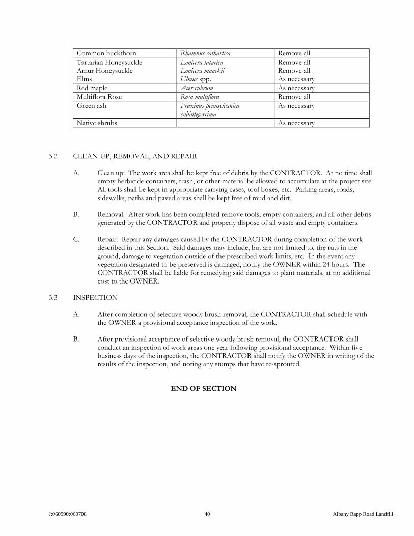
J:060590:060708 40 Albany Rapp Road Landfill
Common buckthorn Rhamnus cathartica Remove all Tartarian Honeysuckle Amur Honeysuckle Elms
Lonicera tatarica Lonicera maackii Ulmus spp.
Remove all Remove all As necessary
Red maple Acer rubrum As necessary Multiflora Rose Rosa multiflora Remove all Green ash Fraxinus pennsylvanica
subintegerrima As necessary
Native shrubs As necessary
3.2 CLEAN-UP, REMOVAL, AND REPAIR
A. Clean up: The work area shall be kept free of debris by the CONTRACTOR. At no time shall empty herbicide containers, trash, or other material be allowed to accumulate at the project site. All tools shall be kept in appropriate carrying cases, tool boxes, etc. Parking areas, roads, sidewalks, paths and paved areas shall be kept free of mud and dirt.
B. Removal: After work has been completed remove tools, empty containers, and all other debris generated by the CONTRACTOR and properly dispose of all waste and empty containers.
C. Repair: Repair any damages caused by the CONTRACTOR during completion of the work described in this Section. Said damages may include, but are not limited to, tire ruts in the ground, damage to vegetation outside of the prescribed work limits, etc. In the event any vegetation designated to be preserved is damaged, notify the OWNER within 24 hours. The CONTRACTOR shall be liable for remedying said damages to plant materials, at no additional cost to the OWNER.
3.3 INSPECTION
A. After completion of selective woody brush removal, the CONTRACTOR shall schedule with the OWNER a provisional acceptance inspection of the work.
B. After provisional acceptance of selective woody brush removal, the CONTRACTOR shall conduct an inspection of work areas one year following provisional acceptance. Within five business days of the inspection, the CONTRACTOR shall notify the OWNER in writing of the results of the inspection, and noting any stumps that have re-sprouted.
END OF SECTION

J:060590:060708 41 Albany Rapp Road Landfill
SECTION 31 13 14
HERBACEOUS SPECIES REMOVAL
PART 1 - GENERAL
1.1 DESCRIPTION
A. This section includes the eradication of herbaceous species, including grasses and forbs, as required for construction of the Albany Landfill mitigation project, complete in all respects, as shown on the drawings and as required by these specifications.
1.2 RELATED SECTIONS
A. Section 32 91 13 – Soil Preparation
B. Section 32 92 19 – Seeding
C. Section 32 93 13 – Perennial Plantings
1.3 QUALITY ASSURANCE
A. Qualifications of workmen: Provide at least one person during execution of this portion of the work that shall be thoroughly familiar with this type of work, means and methods, and the type of materials being used. Said person shall be competent at identification of plant materials to be removed and to be preserved during the season (summer, winter) work is to be completed. Said person shall direct the work performed under this section.
B. Standards: All materials used during this portion of the work shall meet or exceed applicable federal, state, county and local laws and regulations. The use of any herbicide shall follow directions given on the herbicide label. In the case of a discrepancy between these specifications and the herbicide label, the label shall prevail.
1.4 SUBMITTALS
A. Materials: Prior to delivery of any materials to the site, submit to the OWNER a complete list of all materials to be used during this portion of the work. Include complete data on source, amount and quality. This submittal shall in no way be construed as permitting substitution for specific items described on the plans or in these specifications unless approved in writing by the OWNER’S REPRESENTATIVE.
B. Licenses: Prior to any herbicide use the Contractor shall submit to the OWNER a current copy of the appropriate State of New York pesticide applicator’s license for each person who will be applying herbicide at the project site. A copy of each pesticide applicator’s license must be maintained on site at all times during completion of the work.
C. Equipment: Prior to commencement of any work, submit to the OWNER a written description of all mechanical equipment and its intended use during the execution of the work.

J:060590:060708 42 Albany Rapp Road Landfill
PART 2 - PRODUCTS
2.1 MATERIALS
A. Herbaceous species to be removed in areas without standing water or saturated soils shall be treated with Glyphosate, N-(phosphonomethyl) Glycine, trade name Roundup or equivalent as approved in writing by OWNER.
B. Herbaceous species to be removed in areas with standing water or saturated soils shall be treated with Glyphosate, N-(phosphonomethyl) Glycine in a form approved for aquatic applications such as Rodeo or equivalent as approved in writing by OWNER.
C. Selective grass herbicides and other specialty herbicides may also be used in appropriate locations, but only with the prior written approval of the OWNER. For any materials not specifically called for herein, CONTRACTOR shall submit complete identifying information including manufacturer’s literature, manufacturer’s recommendations for use, restrictions on use, MSDS, and any other information requested by the OWNER. Alternatives to specified materials will not be used in the work unless approved by the OWNER in writing.
PART 3 - EXECUTION
3.1 METHOD
A. The CONTRACTOR will treat all vegetation within targeted areas with an approved herbicide. Herbicide application instructions given on the label shall be followed at all times.
B. Targeted areas will be located in the field by the OWNER. Contractor shall not proceed with any herbaceous species removal until the areas of the work have been clearly identified and marked.
C. Care shall be taken not to affect vegetation outside of target areas. If areas outside the limits of work are affected, such areas shall be restored in kind at no additional cost to the OWNER.
D. A supply of chemical absorbent shall be maintained at the project site. Any chemical spills shall be properly cleaned up and reported to the Owner within 24 hours.
E. The CONTRACTOR shall maintain copies at the project site of all current pesticide applicator’s licenses, herbicide labels, and MSDS’s (Material Safety Data Sheets) for all chemicals utilized during completion of the work.
F. Herbicide may be applied using a backpack sprayer, a hand-held wick applicator, or a vehicle mounted high pressure spray unit.
3.2 CLEAN-UP, REMOVAL AND REPAIR
A. Clean up: The work area shall be kept free of debris by the CONTRACTOR. At no time shall empty herbicide containers, trash, or other material be allowed to accumulate at the project site. All tools shall be kept in appropriate carrying cases, tool boxes, etc. Parking areas, roads, sidewalks, paths and paved areas shall be kept free of mud and dirt.
B. Removal: After work has been completed remove tools, empty containers, and all other debris generated by the CONTRACTOR and properly dispose of all waste and empty containers.

J:060590:060708 43 Albany Rapp Road Landfill
C. Repair: Repair any damages caused by the Contractor during completion of the work described in this Section. Said damages may include, but are not limited to, tire ruts in the ground, damage to vegetation outside of the prescribed work limits, etc. In the event any vegetation designated to be preserved is damaged, notify the OWNER within 24 hours. The Contractor shall be liable for remedying said damages to plant materials, at no additional cost to the OWNER.
3.3 INSPECTION
After completion of herbaceous species removal, the Contractor shall schedule with the OWNER a provisional acceptance inspection of the work.
END OF SECTION

J:060590:060708 44 Albany Rapp Road Landfill
SECTION 31 23 00
EXCAVATION AND FILL
PART 1 - GENERAL
1.1 DESCRIPTION
A. Excavation and fill shall include topsoil stripping, soil excavation, topsoil replacement, subsoil replacement, excavation and topsoil material stockpiling construction, and appurtenant items as shown on the Drawings and as detailed in these specifications, for construction of the Albany Landfill mitigation project, complete in all respects.
1.2 RELATED SECTIONS
A. Section 32 92 19 – Seeding B. Stormwater Pollution Prevention Plan (under separate cover)
C. CONTRACTOR is also referred to the standard technical detail drawings for the soil
preparation needs for the bog, dunes, new stream channel, and landfill rooting medium installation that is shows in the Plan Set found in ATTACHMENT 1.
1.3 QUALITY ASSURANCE
A. Qualifications of workmen: provide at least one person who shall be present during execution of this portion of the work and who shall be thoroughly familiar with the type of equipment being used and the Drawings and Specifications. Said person shall direct the work performed under this section.
B. Standards: All materials, equipment, and procedures used during this portion of the work shall meet or exceed applicable federal, state, county and local laws and regulations.
1.4 SUBMITTALS
A. Materials: Prior to delivery of any materials to the site, CONTRACTOR shall submit to the OWNER a complete list of all materials to be used during this portion of the work. The list shall include complete data on source, size and quality. For earth or stone materials not originating on site, CONTRACTOR shall provide a sample of the material, and an affidavit with supporting test data certifying that the material is clean. Submittals shall in no way be construed as permitting substitution for specific items described on the Drawings or in these specifications unless approved in writing by the OWNER.
PART 2 - PRODUCTS
2.1 MATERIALS
A. Topsoil
1. Topsoil shall be suitable organic soil obtained from on site excavation work performed for the Albany Landfill mitigation project. All topsoil shall be stockpiled in accordance with the

J:060590:060708 45 Albany Rapp Road Landfill
provisions of the Stormwater Pollution Prevention Plan for the project, and shall be accepted by the OWNER’S REPRESENTATIVE prior to use in the work.
2. Topsoil from other on-site sources on the OWNER’S property may be used in the work provided the material is supplied by the OWNER from contiguous property, and the OWNER’s authorization for supplemental topsoil use is obtained in writing, in advance.
3. Topsoil from off-site sources shall not be used in the work unless the CONTRACTOR first provides information on organic content, pH, gradation, and soluble salt content for review and approval by the ONWER’S REPRESENTATIVE. Off-site sources of topsoil shall only be accepted for use in the work if they are suitable for wetlands application, as determined by a qualified wetlands ecologist, and with the prior written approval of the OWNER.
B. Unclassified Excavation - Unclassified excavation shall consist of all soil, which is not topsoil. All unclassified excavation shall be from within the limits of work for the Albany Landfill mitigation project, and shall be re-used on site.
C. Stormwater Pollution Prevention Plan Materials and Appurtenances – The final Stormwater Pollution Prevention Plan (bound under separate cover) contains additional requirements for earthwork and soil erosion and sediment control practices. The CONTRACTOR shall conform to the requirements of the Stormwater Pollution Prevention Plan in executing the work shown on the drawings and specified herein.
PART 3 - EXECUTION
3.1 GENERAL
A. The CONTRACTOR shall provide temporary means of preventing erosion of excavated materials into any watercourse, and shall comply with the Stormwater Pollution Prevention Plan for the project.
B. The CONTRACTOR shall provide control and grade stakes for the grading construction. The CONTRACTOR shall arrange for staking with the OWNER and will be responsible for protecting the stakes.
C. Grade all natural planting areas as identified on the drawings to within 0.30 foot (4 inches + 1 inch). More exacting accuracy is not desired, to reduce or minimize soil compaction.
D. Site grading is based on the assumption of a net cut and fill balance, and CONTRACTOR shall plan the work to achieve a balance. CONTRACTOR may vary final grades to achieve a cut and fill balance; however, such alteration of grades shall be permitted only in areas approved, in advance, in writing, by the OWNER. Revised grading shall be otherwise subject to the tolerances specified herein. CONTRACTOR shall not create a grading plan that requires importation of additional fill. If regrading is required to achieve cut and fill balance, CONTRACTOR shall do so at no additional cost to the OWNER.
3.2 TOPSOIL
A. Topsoil excavation shall consist of the stripping of existing topsoil from the excavation areas and the stockpiling of the topsoil material necessary to provide topsoil replacement.

J:060590:060708 46 Albany Rapp Road Landfill
1. Topsoil shall mean the upper portion (A-horizon) of native soil that is a friable loam, generally dark brown to black in color, and containing organic matter, typically in the range of 2-6 percent.
2. Prior to topsoil removal, CONTRACTOR shall confirm removal depth with the OWNER’S REPRESENTATIVE.
3. CONTRACTOR shall remove heavy growths of grass or vegetation from areas of work, prior to stripping.
4. Topsoil shall be stripped so as not to mix with subsoil.
5. Topsoil shall be stockpiled in locations approved by the OWNER, and shall be in compliance with the project Stormwater Pollution Prevention Plan. Stockpiles shall be free from brush, trash, large stones, and other extraneous material.
6. CONTRACTOR shall stockpile sufficient topsoil to replace on the disturbed areas with vegetation, as shown on the Drawings.
B. Topsoil replacement shall consist of re-spreading the topsoil over disturbed areas to be revegetated and the preparation of the topsoil for planting.
C. Finish grading shall be completed in a manner and time frame to minimize compaction during equipment operation. Contractor shall not run equipment traffic across completed areas with topsoil and subsoil replaced. Topsoil and subsoil shall not be worked when moisture content is so great that excessive compaction will occur, nor when it is so dry that dust will be generated or clods produced which will not break readily. Apply water, if necessary, to bring soil to an optimum moisture content for tillage by typical farming equipment.
D. The fill areas shall be graded with uniform slope between points where elevations are given or between such points and existing grades. Finish grading operations shall be perpendicular to the slope. In the excavated locations for emergent or wet prairie wetlands the grading shall be generally uniform between elevation points, but slope irregularity below the proposed water line is allowable.
E. Use equipment of appropriate size and type to achieve a uniform soil surface free of high areas, depressions and tracks, and place in a manner that will minimize settlement. Excessive or differential settlement shall be repaired by the CONTRCTOR, as determined solely by the OWNER, at no additional cost.
F. Do not compact the topsoil over subsoil or re-spread wetland substrates greater than 50 PSI or the value for adjacent undisturbed topsoil, whichever is higher. Follow the cone penetrometer methods outlined in the American Society of Agricultural and Biological Engineers Standards S313.3 and EP542. Use an applicable penetrometer to test soil compaction. If excess compaction of the replaced topsoil or wetland substrates occurs, the CONTRACTOR shall present a plan to the OWNER or OWNER’S representative to eliminate compaction through ripping (at the optimum moisture content) or other approved methodology. The compaction alleviation shall be completed by the CONTRACTOR, at no additional cost.
G. Care shall be exercised in conducting restoration, reclamation and landscaping operations near utilities. If at any time the CONTRACTOR damages the utilities in place, the CONTRACTOR shall pay for the full cost of or repair such damages.

J:060590:060708 47 Albany Rapp Road Landfill
3.4 EXCAVATION
A. Excavation shall consist of the removal of all materials (except topsoil) lying above the topsoil replacement elevation. Unclassified excavation shall proceed as follows:
1. Excavated soil to be re-used shall be used directly in the work to the extent practicable, or when not practicable shall be stockpiled as directed by the OWNER and in conformance with the Stormwater Pollution Prevention Plan.
2. Excavation shall be to the lines and grades shown on the Drawings and to the tolerances in Section 3.1.
3. Over-excavation shall be remedied by replacing with like material, properly compacted and graded, and at no additional cost to the OWNER.
4. Excavation shall be confined to the work limits and all equipment traversing the area of the excavation either for removal of soil or for transport to fill areas or to temporary stockpiles shall be restricted to the limits of work. Any disturbance of areas outside the limits of work shall be restored in kind at no additional cost to the OWNER.
5. Stormwater management during excavation shall be in strict conformance with the Stormwater Pollution Prevention Plan for the project.
6. Unfinished excavation areas shall be properly protected with signs, warning tape, or fences, as necessary to restrict access.
3.5 WATER MANAGEMENT
A. All stormwater shall be managed in accordance with the Stormwater Pollution Prevention Plan.
B. Grading for the project includes the construction of ponded, bogs, streams, and wetland areas. In accordance with the Stormwater Pollution Prevention Plan, water that accumulates on site may be discharged to an adjacent pond for temporary stormwater management to provide dewatered access for pond excavation or final grading. Under no circumstances shall the CONTRACTOR discharge such water except through a soil erosion and sediment control structure constructed in accordance with the Stormwater Pollution Prevention Plan.
C. Excavation and fill is for the construction of dunes, bogs, streams, wetlands and, therefore, water (both surface and ground water) may be present at various times. CONTRACTOR is responsible for all necessary water management, in accordance with the Stormwater Pollution Prevention Plan, necessary to perform the work in the proper manner, and in accordance with the drawings and these specifications.
D. CONTRACTOR shall not discharge any water from the site, except in accordance with the Stormwater Pollution Prevention Plan.
3.6 CLEAN-UP, REMOVAL, AND REPAIR
A. After excavation and fill work is complete, any remaining materials, debris, and trash shall be cleaned and removed from the site by the CONTRACTOR. All waste material shall be properly disposed of in accordance with all applicable laws and regulations. All areas damaged by the CONTRACTOR during the execution of this work shall be repaired by CONTRACTOR and all

J:060590:060708 48 Albany Rapp Road Landfill
areas outside of the construction limits disturbed by construction shall be restored to the pre-construction conditions, at no additional cost to the OWNER.
3.7 INSPECTION
A. Prior to the commencement of planting construction, the CONTRACTOR shall obtain a provisional acceptance of the grading from the OWNER. The CONTRACTOR shall be responsible for scheduling a provisional acceptance inspection with the OWNER.
END OF SECTION

J:060590:060708 49 Albany Rapp Road Landfill
SECTION 31 25 00
EROSION AND SEDIMENT CONTROL
PART 1 PART 1 - GENERAL
1.1 SUMMARY
A. The work in this Section shall include construction and maintenance of temporary and permanent erosion control measures as shown on the Drawings and for all areas disturbed by the CONTRACTOR for the implementation of the Albany Landfill mitigation project. The work will include, but is not necessarily limited to installation and maintenance of all of the measures presented in the Stormwater Pollution Prevention Plan, and generally consists of the following measures:
1) Seeding and mulching 2) Silt fences 3) Sediment traps 4) Sediment basins 5) Drainage swales 6) Appurtenances
B. Related Sections: 1. Section 01 35 43 – Environmental Protection 2. Section 31 23 00 – Excavation and Fill 3. Section 32 92 19 – Seeding 4. Section 32 92 13 – Hydromulching 5. CONTRACTOR is also referred to the standard technical detail drawings for the soil
preparation needs for the bog, dunes, new stream channel, and landfill rooting medium installation that is shows in the Plan Set found in ATTACHMENT 1.
1.2 REGULATORY REQUIREMENTS AND REFERENCES
A. All work for this Section shall be executed in accordance with the New York State Standards and Specifications for Erosion and Sediment Control dated August 2005, or current version.
B. Selected materials specified in Section 2.1 below shall meet the material requirements of the New York State Department of Transportation Standard Specifications for Construction and Materials (NYSDOT) were applicable.
C. The CONTRACTOR shall work in accordance with all State and federal permits.
1.3 OTHER STANDARDS
A. Work performed under this Section will follow the requirements provided in the Stormwater Pollution Prevention Plan (SWPPP) for the project.
1.4 DELIVERY, STORAGE, AND HANDLING
A. Storage areas shall be stable, dry, relatively flat, and well drained and located outside the waterway’s floodplain.

J:060590:060708 50 Albany Rapp Road Landfill
PART 2 - PRODUCTS
2.1 SILT FENCE FABRIC
A. Silt fence fabric shall be woven and consist of monofilaments of polypropylene treated with ultraviolet light stabilizers. The fabric shall have sleeves through which either steel or two-inch square wood posts can be inserted.
B. Silt fence fabric shall be inert to chemicals commonly found in soils and to hydrocarbons.
C. Silt fence fabric shall be resistant to mildew, rot, insects, and rodent attack.
D. Silt fence fabric shall be supported by 14 gauge minimum, galvanized welded wire mesh or polymeric mesh.
2.2 SILT FENCE POSTS
A. Wood shall be composed of sound quality hardwood.
B. Wood posts shall be a minimum of 36 inches long.
C. Steel posts shall be standard T & V section weighing not less than one pound/linear foot.
2.3 MULCH
A. See Section 32 92 13 – Hydromulching of these Specifications
2.4 SEED
A. See Section 32 92 19 – Seeding of these Specifications
2.5 RIP-RAP
A. Rip-Rap shall be of sizes shown on the Drawings and shall be of natural, hard, durable material, rounded or angular. Stone shall be reasonably free of shale or shaley stone. Stone shall be reasonably free of laminations, seams, cracks and other structural defects or imperfections tending to affect its resistance to weather and flows.
B. Where a size specification is supplied as a minimum, at least 90% of the stones shall be of the size specified. Where a size specification is supplied as a maximum no more than 10% of stones may be larger than specified, and the maximum dimension of larger stones shall be subject to the approval of the OWNER’S REPRESENTATIVE. Where a D50 size specification is provided, a minimum of 50% of stones shall be of the size specified or larger.
2.6 SEDIMENT BASIN AND SEDIMENT TRAP SOILS
A. Sediment basins and traps shall be constructed of on-site soil materials, but basin containment berms shall not be constructed of pervious materials including Unified Soil Classification System classes GW, GP, SW or SP.
B. Soil used for berm construction shall be free of organic matter, oversized particles, debris, or other objectionable materials and shall be unfrozen when placed.

J:060590:060708 51 Albany Rapp Road Landfill
2.7 GEOTEXTILE
A. Geotextile shall be non-woven, minimum 12 oz/sy material, with an AOS of no larger than 100 sieve, and shall be manufactured of virgin polypropylene or polyester. Geotextile shall be Mirafi 1120, or equivalent as approved by the OWNER.
2.8 APPURTENANCES
A. Appurtenances include, but are not limited to, sediment basin spillway pipe, anti-seep collars, drain piping, anti-vortex plates, stabilized construction entrance, and miscellaneous concrete.
B. Corrugated metal pipe shall conform to the relevant requirements of NYSDOT Specification 603. Drain piping shall conform to the relevant requirements of NYSDOT Specification 605.
C. Stabilized construction entrance shall conform to the relevant requirements of NYSDOT Specification 209.
D. Concrete used in incidental construction shall conform with the relevant requirements of NYSDOT Specification 501, and have a minimum 28-day compressive strength of 3,000 psi. Reinforcing steel used in incidental construction shall conform with the relevant requirements of NYSDOT Specification 556.
PART 3 - EXECUTION
3.1 GENERAL
A. The CONTRACTOR shall perform all work under this Contract in such a manner that objectionable conditions will not be created in water courses through or adjacent to the project area.
B. The CONTRACTOR shall install the erosion control devices required to control erosion and sedimentation in accordance with applicable requirements based on the sequencing of work and miscellaneous construction activities. The CONTRACTOR shall inspect all erosion and sedimentation control devices on a daily basis and maintain, adjust, relocate and supplement devices to ensure complete control of erosion and prevention of water pollution.
C. The CONTRACTOR shall install erosion and sedimentation control devices prior to soil or vegetation disturbance other than that soil and vegetation disturbance required to install the subject erosion and sedimentation control devices.
D. Temporary erosion and sedimentation control devices shall be maintained in working order throughout the project duration.
E. Soil erosion and sediment control devices shall be constructed at the locations shown on the drawings, and to the lines and grades shown on the drawings.
F. All soil erosion and sediment control devices shall conform with the requirements of the Stormwater Pollution Prevention Plan, which is incorporated by reference and made a part of these specifications.
G. All soil erosion and sediment control devices shall be maintained in accordance with the requirements of the Stormwater Pollution Prevention Plan, including necessary repairs, and

J:060590:060708 52 Albany Rapp Road Landfill
removal and proper disposal of accumulated sediment, at the predetermined terms as described in the Plan.
3.2 Earthwork
A. Fill for sediment basin or sediment trap construction shall be placed on a scarified subgrade.
B. Embankment fill shall be placed at moisture content permitting proper compaction.
C. Embankment fill shall be placed in lifts of approximately six to eight inches, and compacted with the earthmoving equipment so that the entire surface of a lift is traversed by at least one pass of a wheel or tread track.
D. Embankment shall be constructed to 10% above design elevation to account for settlement.
E. Stone fill shall be placed and compacted with earthmoving equipment to a non-movement condition under the equipment load.
F. Rip-rap shall be dumped stone or hand placed, as required, and shall be placed so that stones are uniformly supported and are distributed in size throughout the area. Stones shall be place to the dimensions and thickness indicated on the drawings.
G. Geotextile used in earthwork shall be placed on suitable subgrade that will not damage the geotextile, and adjoining panels shall be overlapped a minimum of 12 inches.
H. Drainage swales shall be excavated to the dimensions required in the Stormwater Pollution Prevention Plan, to the line and grade shown, and shall maintain positive drainage.
3.3 SEEDING AND MULCHING
A. See Section 32 92 19 – Seeding and Section 32 92 13 – Hydromulching of these Specifications.
3.4 SILT FENCES
A. Silt fence shall be installed to follow ground contours and in the locations shown on the Drawings down slope of any area before disturbance by construction activities. The silt fence fabric panels shall be installed loosely with adjacent panels overlapped a minimum of 12 inches. Silt fence material shall be embedded at least six inches beneath ground surface and shall extend upward at least 16 inches above the disturbed area ground surface. The top edge of the fabric shall be reinforced or shall have a one-inch tuck.
END OF SECTION

E:060590:060708 53 Albany Rapp Road Landfill
SECTION 32 91 13
SOIL PREPARATION
PART 1 - GENERAL
1.1 SUMMARY
A. This section includes preparation of soil used in the construction Albany Landfill mitigation project, prior to seeding and/or planting.
B. Related Sections 1. Section 32 92 19 – Seeding 2. Section 32 93 23 – Perennial Plantings 3. CONTRACTOR is also referred to the standard technical detail drawings for the soil
preparation needs for the bog, dunes, new stream channel, and landfill rooting medium installation that is shows in the Plan Set found in ATTACHMENT 1.
1.2 QUALITY ASSURANCE
A. Provide at least one person during execution of this portion of the work that shall be thoroughly familiar with the type and operation of equipment being used. Said person shall direct the work performed under this Section.
B. All materials used during this portion of the work shall meet or exceed all applicable federal, state, county, and local laws and regulations.
1.3 SUBMITTALS
A. Prior to commencement of any work, submit to the OWNER a written description of all mechanical equipment and its intended use during the execution of the work.
PART 2 - PRODUCTS
2.1 MATERIALS
A. None under this Section
PART 3 - EXECUTION
3.1 GENERAL
3.2 A. Protection of Existing Conditions: 1. General: Use every possible precaution to prevent damage to existing conditions to remain such as structures, utilities, plant materials and walks on or adjacent to the site of the work. 2. Barriers: Provide barricades, fences or other barriers to protect existing conditions to remain from damage during construction.

E:060590:060708 54 Albany Rapp Road Landfill
3. Operations: Do not store materials or equipment, does not allow burning of debris, or operate or park equipment under the branches of existing plants to remain. 4. Notification of damages: Give written notification of damaged plants and structures immediately.
3.3 B. Environmental Requirements: 1. Do not work soil when moisture content is so great that excessive compaction will occur, nor when it is so dry that dust will form in the air or those clods will not break readily. Apply water, if necessary, to bring soil to an optimum moisture content for tilling. 2. Do not work soil when muddy or frozen. 3. Do not apply chemicals and pesticides if wind conditions will cause hazardous drift to people or property.
3.4 Surface Preparation:
3.5 Prior to seeding and planting, check compaction of topsoil (0-6” depth). Chisel plowing shall be done in areas of soil compaction. All re-graded surfaces shall be chisel plowed to a depth of approximately 12” prior to topsoil placement.
3.6 Upland Prairie and Wetland Planting: Disc or rotovate, and drag to produce a fine seedbed. Re-check soil compaction as described above after tillage. Repeat treatment until ninety percent or more of penetrometer readings are less than five pounds per square inch.
3.7 The CONTRACTOR shall submit a report including test locations and penetrometer readings at the OWNER’s request.
3.8 Remove foreign matter from the areas to be seeded and/or planted.
3.9 CLEAN-UP, REMOVAL, AND REPAIR
A. After soil preparation is complete, clean up any remaining materials, debris, trash, etc. CONTRACTOR shall not drive over finished areas. If additional compactive effort is imparted to finished areas as result of equipment traffic, CONTRACTOR shall repeat penetrometer testing and confirm compliance with these specifications. If soil exceeds compaction requirements, CONTRACTOR shall re-work soil per Section 31 23 00 Part 3.2.
B. The CONTRACTOR shall repair any damages caused by the CONTRACTOR during completion of the work described in this Section at no cost to the OWNER.
END OF SECTION

E:060590:060708 55 Albany Rapp Road Landfill
SECTION 32 91 14
SOIL CHEMISTRY PARAMETERS
Soil – Chemical Parameters and Restoration Requirements
The project area, including the restoration areas, are comprised of Colonie loamy fine sand, Elnora loamy fine sand, Granby loamy fine sand, Pits, Gravel, Stafford loamy fine sand, Udipsamments, and Adrian muck. These soils series are generally described by deep, excessively drained loamy fine sand to sand, with variations between horizons stemming from small gradations in texture and/or organic matter content. The soil horizons are deep, typically much greater than 60 inches and are generally described in the following sequence:
0 to 12 inches (± 3 inches): loamy fine sand 12 to 25 inches (± 5 inches): fine sand to loamy fine sand 25 to 60+ inches: sand to fine sand
Soil samples from the lowland and upland series were collected throughout the project area and in ecological reference areas (examples of high quality ecological communities proposed to be replicated within the project area). Lowland - The lowlands mapped include soils found in wetlands, typically where water flows and collects, or where the topographical aspect is low and intercepts the water table, creating perennially wet conditions. Uplands - The typical upland soils in the Albany Pine Bush were found on ridge tops and side slopes. Laboratory Analytical Results Soil samples were collected for laboratory analyses of the following parameters: texture (percent sand, silt, and clay), pH, percent organic matter, phosphorous, potassium, calcium, magnesium, and cation exchange capacity. A total of fifteen lowland soils and twenty-six upland soils were analyzed. The results of the analysis follow:
Statistical P K Parameter
Soil Texture pH OM % ppm ppm Ca ppm
Mg ppm CEC
Lowland Soils Average 5.2 15.8 49 49 1942 116 18
Standard Dev 0.9 14.1 59 41 2176 127 21 Max 7.6 45.8 193 151 6201 363 60 Min
varies from sand to loam
3.9 1.4 4 16 49 5 1 Upland Soils
Average 5.5 4.0 59 38 1092 68 7 StDev 0.8 3.0 53 20 1194 66 8 Max 7.3 14.2 177 87 6067 343 42 Min
varies from sand to
loamy sand 4.1 0.7 5 19 21 7 1
Restoration Requirements
Topsoil will be removed prior to disturbance and replaced after grading is completed in the restoration areas. Removed lowland and upland soils shall be stockpiled separately and shall be replaced on the same type of land after restoration. The replaced surface soil shall be analyzed to determine if its chemical parameters are within the

E:060590:060708 56 Albany Rapp Road Landfill
standard deviation of the average value in the preceding table. If needed, the soil shall be amended to bring the replaced soil within the standard deviation for the average value for an individual chemical property.
END OF SECTION

E:060590:060708 57 Albany Rapp Road Landfill
SECTION 32 92 13
HYDROMULCHING
PART 1 - GENERAL
1.1 DESCRIPTION A. This section includes hydromulching of seeded areas disturbed for the Albany Landfill mitigation
project, which are revegetated, where shown on the drawings or called for in these specifications, or called for in the Stormwater Pollution Prevention Plan.
1.2 RELATED SECTIONS
A. Section 32 92 29 – Seeding
1.3 QUALITY ASSURANCE
A. Qualifications of workmen: Provide at least one person during execution of this portion of the work that shall be thoroughly familiar with the type and operation of equipment being used. Said person shall direct the work performed under this section.
B. Standards: All materials used during this portion of the work shall meet or exceed applicable federal, state, county and local laws and regulations.
1.4 SUBMITTALS
A. Materials: Prior to delivery of any materials to the site, submit to the OWNER a complete list of all materials to be used during this portion of the work. Include complete data on source, quantity and quality. This submittal shall in no way be construed as permitting substitution for specific items described on the plans or in these specifications unless approved in writing by the OWNER’S REPRESENTATIVE.
B. Equipment: Prior to commencement of any work, submit to the OWNER a written description of all mechanical equipment and its intended use during the execution of the work.
PART 2 - PRODUCTS
2.1 MATERIALS
A. Wood fiber mulch shall be 100% recycled wood fiber, minimum 99% organic content, such as Re-Fiber Wood manufactured by Wood Recycling, Inc. or equivalent if approved in writing by the OWNER.
B. Tackifier shall be a Polyacrylamide-based product (PAM), with more than 100,000 monomer units per molecule, moderately anionic (18% active sites), such as cf2000 by Construction Fabrics and Materials or equivalent if approved in writing by the OWNER.
PART 3 - EXECUTION

E:060590:060708 58 Albany Rapp Road Landfill
3.1 METHOD
A. The CONTRACTOR shall use 25 pounds of tackifier and 1,000 pounds of wood fiber mulch per acre to be treated. A minimum of 1,000 gallons of slurry, mixed in a tank with a mechanical agitator shall be applied per acre.
B. Hydromulch designated areas with a uniform, even coat of slurry after seeding. Take care not to spray adjacent areas, existing vegetation, pavement, and open water.
3.2 CLEAN-UP, REMOVAL AND REPAIR
A. Clean up: CONTRACTOR shall keep the work area free of debris. After the work is complete, clean up any remaining materials, debris, trash, etc. Do not drive or walk over hydromulched area, to minimize disturbance.
B. Removal: After work has been completed remove any tools, equipment, empty containers, and all other debris generated by the CONTRACTOR.
C. Repair: Repair any damages caused by the CONTRACTOR during completion of the work described in this section at no additional cost to OWNER. If hydromulch is spread beyond limits of work on to existing vegetation, CONTRACTOR shall, at the direction of the OWNER, remove the hydromulch and restore existing vegetation in kind, at no additional cost to the OWNER.
3.3 INSPECTION
A. After completion of hydromulching, the CONTRACTOR shall schedule with the OWNER a final acceptance inspection of the work.
END OF SECTION

E:060590:060708 59 Albany Rapp Road Landfill
SECTION 32 92 19
SEEDING
PART 1 - GENERAL
1.1 SUMMARY
A. This section includes the seeding of areas with native plant seeds, as necessary for the Albany Landfill mitigation project, as shown in the mitigation and restoration plan.
B. Related Sections
1. Section 32 91 13 – Soil Preparation 2. Section 32 93 13 – Perennial Plantings
1.2 QUALITY ASSURANCE
A. Provide at least one person during execution of this portion of the work that shall be thoroughly familiar with the type and operation of equipment being used. Said person shall direct the work performed under this section.
B. All materials used during this portion of the work shall meet or exceed applicable federal, state, county and local laws and regulations. All seed shall be free from insects and disease. Species shall be true to their scientific name as specified.
1.3 SUBMITTALS
A. Prior to delivery of any materials to the site, submit to the OWNER a complete list of all seed to be used during this portion of the work, including a certified affidavit from the seed supplier attesting to the quantity, quality, source, and composition of the seed in each of the supplied containers. This submittal shall in no way be construed as permitting substitution for specific items described on the plans or in these specifications unless approved in writing by the OWNER.
B. Prior to commencement of any work, submit to the OWNER a written description of all mechanical equipment and its intended use during the execution of the work.
C. After the work is complete submit to the OWNER record drawings including a listing of all species installed, and quantities installed.
PART 2 - PRODUCTS
2.1 MATERIALS
A. All grass species shall be supplied as pure live seed (PLS). Submit to the OWNER lab germination test results.
B. Seed of all species native to New York shall be from within a 300-mile radius of the project site. If certain species are unavailable within this radius, substitute species and/or sources outside of

E:060590:060708 60 Albany Rapp Road Landfill
the 300-mile radius may be used, but only with the prior written approval of the OWNER’S REPRESENTATIVE.
C. Straw or hay for erosion control shall be clean, seed-free hay or threshed straw of wheat, rye, oats, or barley.
D. Native plant species and quantities shall be as shown on the Drawings.
PART 3 - EXECUTION
3.1 GENERAL
A. Seeds shall have proper stratification and/or scarification to break seed dormancy for spring planting.
B. All legumes shall be inoculated with proper rhizobia at the appropriate time prior to planting.
C. Seeding shall be preferentially conducted as a late fall dormant seeding (after November 1) or in early spring (as soon as the soil is free of frost and in workable condition, but no later than June 15).
D. All seed shall be installed with a rangeland type grain drill or no-till planter, such as by Truax, or equivalent as approved in writing by the OWNER, or by hydroseeding.
E. If soil is too wet to install seed using grain drill or no-till methods, a mechanical broadcast seeder, such as by Cyclone, or hydroseeding/hydromulching may be used. Hand broadcasting of seed may also be employed. Within 24 hours or as soon as site conditions permit, broadcast seeded areas shall be rolled or dragged perpendicular to the slope.
F. Within seven days of seeding, crimp 2,000 pounds per acre of straw or hay into seeded areas for erosion control or hydromulch in accordance with Specification 32 92 13. Crimp mulch immediately after application. Crimp with a straight disc or specialized crimping roller pulled at right angles to slopes. Keep equipment and vehicle traffic off mulched and seeded areas.
G. If area to be seeded was treated with herbicide, seeding shall occur no less than 14 days after herbicide application.
H. Staking Perimeter of Seed Zones: Stake the perimeter of zones determined by different seed mix types at the locations shown on the drawings with 3 feet long wood lath stakes at 100-300 feet on center. Spray paint top 6 inches of each stake on both sides. Tie ribbons securely to stake 6 inches below top of stake. Color code paint and ribbon to correspond with each planting mix. 1. Review of Seed Mix Locations: Ecologist will review and adjust layout to meet field conditions without additional cost to owner prior to the commencement of seeding. 2. Notification of Review: Notify the ecologist within at least 3 days prior to the anticipated date for review of the seed mix locations, for the purpose of adjusting the seed mix locations.
I. Prior to starting work, calibrate and adjust seeding equipment to sow seeds at the proper seeding rate. Equipment shall be operated in a manner to insure complete coverage of the entire area to be seeded.
E:060590:060708 61 Albany Rapp Road Landfill
1. Prepare soil and restore grading work where existing cover crop has been disturbed. 2. Drill-seed across slope parallel with the contours; not up and down slope. 3. Drill wildflower and grass seeds no deeper than 1/2 inch depth. 4. Implement and maintain erosion control measures within planting areas. 5. Maintain erosion control installed materials until grasses and wildflowers are established and throughout the maintenance period.
3.2 CLEAN-UP, REMOVAL, AND REPAIR
A. The work area shall be kept free of debris by the CONTRACTOR. After seed installation is complete, clean up any remaining materials, debris, trash, etc. Do not drive over seeded areas, to minimize disturbance.
B. After work has been completed remove any tools, equipment, empty containers, and all other debris generated by the CONTRACTOR.
C. Repair any damage caused by the CONTRACTOR during completion of the work described in this section, at no cost to the OWNER.
END OF SECTION
E:060590:060708 62 Albany Rapp Road Landfill
SECTION 32 92 20
COVER CROP SEEDING
PART 1 - GENERAL
1.1 DESCRIPTION A. This section includes installation of cover crop seed in any area of disturbed soil required for the
construction of the Albany Landfill mitigation project, which may or may not be final planting to native plantings and species.
1.2 RELATED SECTIONS
A. Section 31 12 02 – Herbaceous Species Removal
B. Section 32 91 13 – Soil Preparation
C. Section 32 93 13 – Perennial Plantings
1.3 QUALITY ASSURANCE
A. Qualifications of workmen: provide at least one person during execution of this portion of the work that shall be thoroughly familiar with the type and operation of equipment being used. Said person shall direct the work performed under this section.
B. Standards: all materials used during this portion of the work shall meet or exceed applicable federal, state, county and local laws and regulations. All seed shall be free from insects and disease. Species shall be true to their scientific name as specified.
1.4 SUBMITTALS
A. Materials: Prior to delivery of any materials to the site, submit to the OWNER a complete list of all seed to be used during this portion of the work. Include complete data on source, quantity and quality. This submittal shall in no way be construed as permitting substitution for specific items described on the plans or in these specifications unless approved in writing by the OWNER.
B. Equipment: Prior to commencement of any work, submit to the OWNER a written description of all mechanical equipment and its intended use during the execution of the work.
D. After the work is complete submit to the OWNER record drawings including a listing of all species installed, and quantities installed.

E:060590:060708 63 Albany Rapp Road Landfill
PART 2 - PRODUCTS
2.1 UPLAND NATIVE GRASSLAND COVER CROP SPECIES LIST
SCIENTIFIC NAME COMMON NAME POUNDS/ACRE
Avena sativa (Spring) Oats 30.00
Lolium multiflorum (Spring) Annual rye 30.00
Secale cereale (Fall) Winter rye 40.00
2.2. WETLAND COVER CROP SPECIES LIST
SCIENTIFIC NAME COMMON NAME POUNDS/ACRE
Echinochloa crusgalli Barnyard grass 0.50
Lolium multiflorum Annual rye 20.00
Polygonum spp. Smartweed 0.50
2.3. NEW STREAM CHANNEL COVER CROP
SCIENTIFIC NAME COMMON NAME POUNDS/ACRE
Echinochloa crusgalli (Spring) Barnyard grass 20.00
Lolium multiflorum (Spring) Annual rye 20.00
Secale cereale (Fall) Winter rye 60.00
2.4 TREE PLANTING AREA COVER CROP
SCIENTIFIC NAME COMMON NAME POUNDS/ACRE
Lolium multiflorum (Spring/fall) Annual rye 30.00
Echinochloa crusgalli (Spring) Barnyard grass 20.00
2.5 MATERIALS
A. All grass species shall be supplied as pure live seed. Submit to the OWNER lab germination test results.

E:060590:060708 64 Albany Rapp Road Landfill
B. Straw or hay for erosion control shall be clean, seed-free hay or threshed straw of wheat, rye, oats, or barley.
PART 3 - EXECUTION
3.1 METHOD A. Seeds shall have proper stratification and/or scarification to break seed dormancy for spring planting. B. Seeding shall be preferentially conducted as a late fall dormant seeding (after November 1) or in early
spring (as soon as the soil is free of frost and in a workable condition but no later than June 15).
C. All seed shall be installed with a rangeland type grain drill or no-till planter, such as by Truax, or equivalent as approved in writing by the OWNER, or by hydroseeding/hydromulching.
D. If soil is too wet to install seed by grain drill or no till methods, a mechanical broadcast seeder, such as by Cyclone, or hydroseeding, may be used. Hand broadcasting of seed may also be employed. Within 24 hours, or as soon as site conditions permit, broadcast seeded areas shall be rolled or dragged perpendicular to the slope.
E. Within seven days of seeding, crimp 2,000 pounds per acre of straw or hay for erosion control onto slopes greater than one foot horizontal to five foot vertical (1:5), or hydromulch in accordance with specification 32 92 13.
F. If area to be seeded was treated with herbicide, seeding shall occur no less than 14 days after herbicide application.
3.2 CLEAN-UP, REMOVAL AND REPAIR
A. Clean up: the work area shall be kept free of debris by the CONTRACTOR. After seed installation is complete, clean up any remaining materials, debris, trash, etc. Do not drive over seeded areas to minimize disturbance.
B. Removal: after work has been completed remove any tools, equipment, empty containers, and all other debris generated by the CONTRACTOR .
C. Repair: repair any damages caused by the CONTRACTOR during completion of the work described in this section.
END OF SECTION

E:060590:060708 65 Albany Rapp Road Landfill
SECTION 32 93 13
PERENNIAL PLANTINGS
PART 1 – GENERAL
1.1 DESCRIPTION
A. This section includes installation of live herbaceous perennial plants, as required for construction of the Albany Landfill mitigation project.
1.2 RELATED SECTIONS
A. Section 32 91 13 – Soil Preparation
B. Section 32 92 19 – Seeding
1.3 QUALITY ASSURANCE
A. Qualifications of workmen: provide at least one person during execution of this portion of the work that shall be thoroughly familiar with the type and operation of equipment being used. Said person shall direct the work performed under this section.
B. Standards: all materials used during this portion of the work shall meet or exceed applicable federal, state, county and local laws and regulations. All live herbaceous perennial plants, tubers, bulbs, and dormant rootstocks of herbaceous perennial plants shall be free from insects and disease.
1.4 SUBMITTALS
A. Materials: Prior to delivery of any materials to the site, CONTRACTOR shall submit to the OWNER a complete list of all live herbaceous perennial plants, tubers, bulbs, and dormant rootstocks of herbaceous perennial plants to be used during this portion of the work. The list shall include a certified affidavit from the plant supplier attesting to the plant source, quantity and quality. This submittal shall in no way be construed as permitting substitution for specific items described on the plans or in these specifications unless approved in writing by the OWNER’s representative.
B. Equipment: Prior to commencement of any work, submit to the OWNER a written description of all mechanical equipment and its intended use during the execution of the work.
C. After the work is complete submit to the OWNER record drawings including a listing of all species installed, and quantities installed.

E:060590:060708 66 Albany Rapp Road Landfill
PART 2 - PRODUCTS
2.1 MATERIALS
A. Live herbaceous perennial plants shall be from within a 300-mile radius of the project site and native to New York. Species shall be true to their scientific name as specified. If certain species are unavailable within this radius, substitute species and/or sources outside of the 300-mile radius may be used, but only with the prior written approval of the OWNER’S REPRESENTATIVE.
B. All live herbaceous perennial plants shall be nursery grown stock unless approved in writing by the OWNER.
C. A percentage of trees and shrubs will be planted as Root Production Method (RPM) grown material. At a minimum, 50% of the trees and shrubs will be RPM grown stock.
D. Plant species and quantities shall be as shown on the Drawings.
PART 3 - EXECUTION
3.1 METHOD
A. Planting of all live herbaceous perennial plants, tubers, bulbs, and dormant rootstocks of herbaceous perennial plants shall be completed after May 15 but no later than July 15. Herbaceous perennial plants, trees, and shrubs can be installed after August 30 until October.
B. All live herbaceous plants shall be potted, nursery grown stock unless approved in writing by the OWNER. Do not remove container-grown stock from containers until planting time. All plant material, included collected stock, shall comply with New York State and Federal laws with respect to inspection for plant diseases and insect infestations.
C. All live herbaceous perennial plants, tubers, bulbs, and dormant rootstocks of herbaceous perennial plants shall be approved by the OWNER prior to installation.
D. Provide healthy, vigorous live herbaceous perennial plants; provide freshly dug tubers, bulbs, and dormant rootstocks of herbaceous perennial plants. Do not use materials that have been in cold storage for longer than 45 days. 5. Plants shall be free from insects and diseases and must show appearance of normal health and vigor.
E. Deliver live herbaceous perennial plants, tubers, bulbs, and dormant rootstocks of herbaceous perennial plants to project site after preparations for planting have been completed.
F. Live herbaceous perennial plants, tubers, bulbs, and dormant rootstocks of herbaceous perennial plants shall be packed in such a manner as to insure adequate protection against wind damage, desiccation, and other physical damage while in transit.
G. If planting is delayed more than four hours after delivery, keep plants in refrigerated container or set plants in shade protected from weather and mechanical damage, and keep moist and cool.

E:060590:060708 67 Albany Rapp Road Landfill
H. Live herbaceous perennial plants, tubers, bulbs, and dormant rootstocks of herbaceous perennial plants shall be installed in areas shown on the Drawings.
I. If planting into an area treated with herbicide, plant materials shall be installed not less than 14 days after herbicide treatment.
J. Emergent wetland plantings shall be protected from geese herbivory. Cages or other proposed protection methods will be submitted in writing and approved by project ecologist shall be used in emergent zones.
3.2 CLEAN-UP, REMOVAL AND REPAIR
A. Clean up: the work area shall be kept free of debris by the CONTRACTOR. After the work is complete, clean up any remaining materials, plant containers, debris, trash, etc. Do not drive or walk over planted areas, to minimize disturbance.
B. Removal: after work has been completed remove any tools, equipment, empty containers, and all other debris generated by the CONTRACTOR.
C. Repair: repair any damages caused by the CONTRACTOR during completion of the work described in this section.
3.3 INSPECTION
A. After completion of planting, the CONTRACTOR shall schedule with the OWNER a provisional acceptance inspection of the work.
END OF SECTION

E:060590:060708 68 Albany Rapp Road Landfill
SECTION 32 93 43
TREES AND SHRUBS PART 1 - GENERAL 1.1 RELATED DOCUMENTS
A. Drawings and general provisions of the Contract, including General and Supplementary
Conditions and Division 01 Specification Sections, apply to this Section.
1.2 SUMMARY
A. Section Includes:
1. This section includes planting of native trees and shrubs. B. Related Sections:
Selective Woody Brush Removal 31 13 13 Seeding 32 92 19 Perennial Plantings 32 93 13
1.3 DEFINITIONS
A. Backfill: The earth used to replace or the act of replacing earth in an excavation. B. Finish Grade: Elevation of finished surface of planting soil.
C. Sub-grade: Surface or elevation of subsoil remaining after completing excavation, or top surface
of a fill or backfill, before placing planting soil.
D. Topsoil: Natural or cultivated surface-soil layer containing organic matter and sand, silt, and clay particles; friable, pervious, and black or a darker shade of brown, gray, or red than underlying subsoil; reasonably free of subsoil, clay lumps, gravel, and other objects more than 4 inches in diameter.
E. Manufactured Soil: Soil produced off-site by homogeneously blending mineral soils or sand with
stabilized organic soil amendments to produce topsoil or planting soil.
F. Planting Soil: Native or imported topsoil, manufactured topsoil, or surface soil modified to become topsoil; mixed with soil amendments.
G. Subsoil: All soil beneath the topsoil layer of the soil profile, and typified by the lack of organic
matter and soil organisms. H. Balled and Burlapped Stock: Trees and shrubs dug with firm, natural balls of earth in which they
are grown, with ball size not less than diameter and depth recommended by ANSI Z60.1 for type and size of tree or shrub required; wrapped, tied, rigidly supported, and drum laced as recommended by ANSI Z60.1.

E:060590:060708 69 Albany Rapp Road Landfill
1. Clump: Three or more young trees planted in groups that have grown together as a single tree having three or more main stems or trunks.
2. Container-Grown Stock: Healthy, vigorous, well-rooted trees and shrubs grown in a container
with well-established root system reaching sides of container and maintaining a firm ball when removed from container. Container shall be rigid enough to hold ball shape and protect root mass during shipping and be sized according to ANSI Z60.1 for type and size of exterior plant required.
3. Multi-Stem: Three or more main stems emerging from a single root crown or at a point right
above the root crown.
1.4 SUBMITTALS
A. Qualification Data: For qualified Contractor. B. Product Data: For each type of product indicated. C. Samples for Verification: For each of the following:
1. 1 lb (0.45 kg) of mineral mulch for each color and texture of stone required, in labeled
plastic bags. 2. 1 lb (0.45 kg) samples of all wood mulch types that will be used, in labeled plastic bags.
D. Planting Schedule: Indicating anticipated planting dates for trees and shrubs. E. Materials: Prior to delivery of any materials to the site, submit to the Owner a complete list of all
trees and shrubs to be installed during this portion of the Work. Include complete data on source, quantity and quality.
1. This submittal shall in no way be construed as permitting substitution for specific items
described on the Plan set or in these Specifications unless approved in writing by the Owner. F. Planting Schedule: Indicating anticipated planting dates for each type of planting. G. Equipment: Prior to commencement of any work, submit to the Owner a written description of
all mechanical equipment and its intended use during the execution of the work. H. Post Construction Drawings: After the work is complete submit to the Owner “as-built” plans
including a listing of all species installed, and quantities installed. Mark in red ink on the original Plan set any field changes or deviations from the original Plan set.
I. Maintenance Instructions: Recommended procedures to be established by Owner for
maintenance of trees and shrubs during a calendar year.
1. Submit before expiration of required maintenance periods. J. Warranty: Sample of special warranty.
1.5 QUALITY ASSURANCE

E:060590:060708 70 Albany Rapp Road Landfill
A. Installer Qualifications: A qualified Contractor whose work has resulted in successful establishment of trees and shrubs.
1. Installer's Field Supervision: The Contractor is required to maintain an experienced full-time
supervisor on Project site when planting is in progress. B. Supervisor Qualifications: Provide at least one person who shall be present at all times during
execution of this portion of the work; that shall be thoroughly familiar with the type and operation of equipment being used. Said person shall direct all work performed under this section.
C. Standards: All materials used during this portion of the Work shall meet or exceed applicable
federal, state, county and local laws and regulations. All plant materials shall be free from insects and disease. Species shall be true to their scientific name as specified.
1. Do not use materials that have been dug more than 30 days in advance. 2. No trees or shrubs dug with a ball shall be accepted if the ball is broken before or during
planting operations, except by special approval of the Owner. 3. Trees and shrubs with broken major branches, or badly bruised or damaged bark, are not
acceptable and may be rejected by the Owner.
4. All trees and shrubs are to be installed in accordance with the standard specifications shown on the Plan, except as modified herein.
D. Materials: The Contractor shall submit to the Owner for approval a complete list of all materials
to be used during this portion of the Work prior to delivery of any materials to the site.
1. Include complete data on source, amount and quality. 2. This submittal shall in no way be construed as permitting substitution for specific items
described on the Plans or in these Specifications unless approved in writing by the Owner. 3. Notify the Owner of sources of planting materials 10 days in advance of delivery to site.
Provide healthy, vigorous, freshly dug plant materials.
E. Provide quality, size, genus, species, and variety of trees and shrubs indicated, complying with applicable requirements in ANSI Z60.1, "American Standard for Nursery Stock."
1. Substitutions will not be permitted without the approval of the Owner. 2. If proof is submitted that any tree or shrub specified is not obtainable, a proposal will be
considered for use of nearest equivalent size or variety, with an equitable adjustment to the contract price. Such proof shall be substantiated in writing to the Owner.
3. All aspects of this project have been designed to work together; native plant arrangements
and restorations are carefully designed for the planting site conditions as well as species compatibility. Changes to the plans or specifications must be approved in writing by Applied Ecological Services (AES) or the Owner. AES is in no way responsible for problems resulting from any changes to the design made by any party without the written permission of AES.

E:060590:060708 71 Albany Rapp Road Landfill
F. Observation: The Owner may inspect trees and shrubs either at place of growth or at site before
planting for compliance with requirements for genus, species, variety, size, and quality. The Owner retains right to inspect trees and shrubs further for size and condition of balls and root systems, insects, injuries, and latent defects and to reject unsatisfactory or defective material at any time during progress of work.
G. Remove rejected trees or shrubs immediately from Project site.
H. Preinstallation Conference: Conduct conference at the Project Site in order to coordinate
equipment movement within planting areas and to avoid soil compaction. Review underground utility location maps and plans. This meeting shall be coordinated by the Construction Project Manager.
I. Equipment utilized in planting areas shall have low unit pressure ground contact.
1. Topsoil compaction shall not exceed 70% standard proctor density (ASTM D698). 2. Subsoil compaction shall not exceed 92% standard proctor density (ASTM D698).
1.6 DELIVERY, STORAGE, AND HANDLING
A. Deliver trees and shrubs freshly dug.
1. Immediately after digging up bare-root stock, pack root system in wet straw, hay, or other suitable material to keep root system moist until planting.
B. Do not prune trees and shrubs before delivery except as approved by Owner. C. Protect bark, branches, and root systems from sun scald, drying, sweating, whipping, and other
handling and tying damage. Do not bend or bind-tie trees or shrubs in such a manner as to destroy their natural shape. Provide protective covering for all trees and shrubs during delivery.
D. Do not drop trees or shrubs during delivery and handling. E. Handle planting stock by root ball. F. Deliver trees and shrubs after preparations for planting have been completed and install
immediately. If planting is delayed more than six hours after delivery, set trees and shrubs and trees in shade, protected from weather and mechanical damage, and keep roots moist.
1. Heel-in bare-root stock. Soak roots that are in dry condition in water for two hours. Reject
dried-out plants. 2. Set balled stock on ground and cover ball with soil, peat moss, sawdust, or mulch. 3. Do not remove container-grown stock from containers before time of planting. 4. Water root systems of trees and shrubs stored on-site with a fine-mist spray. Water as often
as necessary to maintain root systems in a moist condition.

E:060590:060708 72 Albany Rapp Road Landfill
1.7 PROJECT CONDITIONS
A. Planting Restrictions: Coordinate planting periods with maintenance periods to provide required maintenance from date of Substantial Completion.
1. Planting of trees and shrubs shall be completed between September 15 and November 15.
B. Weather Limitations: Proceed with planting only when existing and forecasted weather
conditions permit planting to be performed according to manufacturer's written instructions and warranty requirements.
1. When conditions are such that, by reason of drought, excessive moisture, or other factors,
satisfactory results are not likely to be obtained, the Work will be stopped by the Owner or AES and shall be resumed only when directed.
C. Coordination with Seeded Areas: Plant trees and shrubs after finish grades are established and
before planting seeded areas unless otherwise acceptable to AES or Owner.
1. When planting trees and shrubs after lawns, protect lawn areas and promptly repair damage caused by planting operations.
1.8 WARRANTY
When warranties are required, verify with Owner's Counsel that special warranties stated in this article are not less than remedies available to Owner under prevailing local laws.
A. Special Warranty: Contractor’s standard form in which Contractor agrees to repair or replace
plantings and accessories that fail in materials, workmanship, or growth within specified warranty period.
1. Failures include, but are not limited to, the following:
a. Death and unsatisfactory growth, except for defects resulting from lack of adequate maintenance, neglect, abuse by Owner, or incidents that are beyond Contractor's control.
b. Structural failures including plantings falling or blowing over.
2. Warranty Periods from Date of Substantial Completion:
a. Trees and shrubs in formalized landscape portions of the Site as defined in the Plans: One
year b. Trees and shrubs in restoration portions of the Site as defined in the Plans: Three years
3. Include the following remedial actions as a minimum:
a. Remove dead plants immediately. Replace immediately unless required to plant in the succeeding planting season.
b. Replace plants that are more than 30 percent dead or in an unhealthy condition at end of
warranty period.

E:060590:060708 73 Albany Rapp Road Landfill
c. A limit of one replacement of each plant will be required except for losses or replacements due to failure to comply with requirements.
d. Provide extended warranty for replaced plant materials; warranty period equal to original
warranty period. 1.9 MAINTENANCE SERVICE
A. Initial Maintenance Service for Trees and Shrubs: Provide full maintenance by skilled employees
of the Contractor. Maintain as required in Part 3. Begin maintenance immediately after each area is planted and continue until plantings are healthy, well established, and Provisional Acceptance has been achieved but for not less than maintenance period below.
1. Maintenance Period for formalized landscape portions of the Site as defined in the Plans:
One year from date of Provisional Acceptance. 2. Maintenance Period for restoration portions of the Site as defined in the Plans: Three years
from date of Provisional Acceptance. B. Continuing Maintenance Proposal: Contractor shall submit to the Owner, in the form of a
standard yearly (or other period) maintenance agreement, starting on date initial maintenance service is concluded. State services, obligations, conditions, and terms for agreement period and for future renewal options.
PART 2 - PRODUCTS 2.1 MATERIAL
A. General: Furnish nursery-grown trees and shrubs complying with ANSI Z60.1, with healthy
root systems developed by transplanting or root pruning. Provide well-shaped, fully branched, healthy, vigorous stock free of disease, insects, eggs, larvae, and defects such as knots, sun scald, injuries, abrasions, and disfigurement.
B. Provide trees and shrubs of sizes, grades, and ball or container sizes complying with ANSI Z60.1
for types and form of trees and shrubs required. Trees and shrubs of a larger size may be used if acceptable to Owner, with a proportionate increase in size of roots or balls.
C. Root-Ball Depth: Furnish trees and shrubs with root balls measured from top of root ball,
which shall begin at root flare according to ANSI Z60.1. Root flare shall be visible before planting.
D. Label at least one tree and one shrub of each variety and caliper with a securely attached,
waterproof tag bearing legible designation of botanical and common name. E. Where formal arrangements or consecutive order of trees or shrubs is shown, select stock for
uniform height and spread, and number label to assure symmetry in planting. F. The original parent generation of plants shall be from within a 200-mile radius of the project
site. Species shall be true to their scientific name as specified and native to New York. G. Tree and Shrub Measurements: Measure according to ANSI Z60.1 with branches and trunks or
canes in their normal position. Do not prune to obtain required sizes. Take caliper

E:060590:060708 74 Albany Rapp Road Landfill
measurements 6 inches (150 mm) above the ground for trees up to 4 inch (100-mm) caliper size, and 12 inches (300 mm) above the ground for larger sizes. Measure main body of tree or shrub for height and spread; do not measure branches or roots tip-to-tip.
2.2 SHADE AND FLOWERING TREES
A. Shade Trees: Single-stem trees with straight trunk, well-balanced crown, and intact leader, of
height and caliper indicated, complying with ANSI Z60.1 for type of trees required.
1. Provide balled and burlapped trees for all shade trees over 2” caliper or > 6’ height. 2. Branching Height: One-half of tree height.
B. Small Trees: Branched or pruned naturally according to species and type, with relationship of
caliper, height, and branching according to ANSI Z60.1; stem form as follows:
1. Stem Form: Single trunk or multi-trunk as specified in the planting schedule. 2. Provide balled and burlapped or container-grown trees, for all trees under 2” caliper or < 6’
height.
2.3 NYDECIDUOUS SHRUBS
A. Form and Size: Shrubs with not less than the minimum number of canes required by and measured according to ANSI Z60.1 for type, shape, and height of shrub.
1. Shrub sizes indicated are sizes after pruning. 2. Provide balled and burlapped or container-grown shrubs.
2.4 CONIFEROUS EVERGREENS
A. Form and Size: Normal-quality, well-balanced, coniferous evergreens, of type, height, spread,
and shape required, complying with ANSI Z60.1. B. Form and Size: Specimen quality as described, symmetrically shaped coniferous evergreens.
1. Shearing Designation: Natural, never sheared. 2. Provide balled and burlapped trees for all trees over 6’ height.
2.5 BROADLEAF EVERGREENS
A. Form and Size: Normal-quality, well-balanced, broadleaf evergreens, of type, height, spread, and shape required, complying with ANSI Z60.1.
B. Form and Size: Specimen quality as described symmetrically shaped broadleaf evergreens.
1. Shearing Designation: Natural, never sheared. 2. Provide balled and burlapped or container-grown trees and shrubs.

E:060590:060708 75 Albany Rapp Road Landfill
2.6 SOIL PREPARATION
A. Topsoil: All planting areas should have a minimum of 3 inches of topsoil, ASTM D 5268, pH range of 5.5 to 7, a minimum of 3-5 percent organic material content. Acceptable topsoil shall consist of loose friable loam, free of heavy clay, refuse, stumps and large roots, rocks over 2 inches (50 mm) in diameter, brush, weeds and weed seeds, or other material which would be detrimental to the proper development of vegetative growth.
1. Source: Reuse surface soil stockpiled on-site. Verify suitability of stockpiled surface soil to
produce topsoil. Clean surface soil of roots, plants, sod, stones, clay lumps, and other extraneous materials harmful to plant growth.
a. Supplement with imported or manufactured topsoil from off-site sources when quantities
are insufficient. Obtain topsoil displaced from naturally well-drained construction or mining sites where topsoil occurs at least 4 inches (100 mm) deep; do not obtain from agricultural land, bogs or marshes.
2. Prior to planting, confirm topsoil placement by the Earthwork Contractor in all planting
zones as specified in the grading specifications. 3. Prior to planting, examine the compaction of topsoil (0-6” depth) and normal subsoil depth
(6-12” depth). A 150 lb. person should leave no greater than a ¼” deep footprint. B. Areas which have been excavated into subsoil should be amended by the Earthwork Contractor
in the following process: Over excavate to 6 inches below the final elevations shown on plans Apply and spread evenly enough topsoil achieve final grades as specified in the grading plans.
C. Undulation or irregularities in the surface that would interfere with the Contractor's operations
or maintenance shall be leveled before the next specified operation. D. In areas with a slope greater than 10:1, ensure that disc tracks run parallel to the contour so as
not to encourage rilling.
2.7 ORGANIC SOIL AMENDMENTS
A. Compost: Well-composted, stable, and weed-free organic matter, pH range of 5.5 to 8; moisture content 35 to 55 percent by weight; 100 percent passing through 3/4-inch; soluble salt content of 5 to 10 decisiemens/m; not exceeding 0.5 percent inert contaminants and free of substances toxic to plantings; and as follows:
1. Organic Matter Content: 50 to 60 percent of dry weight.
B. Manure: Well-rotted, unleached, stable or cattle manure containing not more than 25 percent by
volume of straw, sawdust, or other bedding materials; free of toxic substances, stones, sticks, soil, weed seed, and material harmful to plant growth.
2.8 FERTILIZER
A. Fertilizer: ‘Mag-Amp’ (7-40-6) or equal, complete, slow-release granular type fertilizer; or Agri-
Form Prolonged Nitrogen Release (20-10-5) containing the following percentages by weight: 20 percent nitrogen, 10 percent phosphorous, and 5 percent potash; incorporated into the soil with

E:060590:060708 76 Albany Rapp Road Landfill
granular fertilizer (‘corn’ fertilizer 0-46-10), containing the following percentages by weight: 0 percent nitrogen, 46 percent phosphorous, 10 percent potash.
1. These fertilizers shall be used together according to manufacturer’s rate instructions; or
‘Woodace’ Slow-release tablet fertilizers (14-3-3) by Estech, Inc. Corp.
2.9 MULCHES
A. Mulch as specified in plans. B. Organic Mulch: Free from deleterious materials and suitable as a top dressing of trees and
shrubs, consisting of one of the following:
1. Shredded Hardwood Mulch: Shall be twice shredded hard wood mulch of uniform texture and size, and shall be a slow decomposing, all organic material. The mulch shall be dark brown in color and free of foreign material.
C. Mineral Mulch: Hard, durable stone, washed free of loam, sand, clay, and other foreign
substances, of following type, size range, and color:
1. Type: Rounded riverbed gravel or smooth-faced stone. 2. Size Range: 2 inch maximum, 3/4 inch minimum. 3. Color: Uniform tan-beige color range acceptable to Owner.
PART 3 - EXECUTION 3.1 EXAMINATION
A. Examine areas to receive trees and shrubs for compliance with requirements and conditions
affecting installation and performance. B. Ensure that finish grades slope to drain, are free of depressions or other irregularities after
thorough settlement and compaction of soil, and are uniform in slope between grading controls and the elevations indicated on Drawings.
1. If finish grades are determined by the Contractor and the Project Coordinator to be
insufficient for planting, the Site Clearing and Earthwork Contractor shall re-grade areas as directed by the Project Coordinator.
C. Ensure topsoil was uniformly distributed in a quantity sufficient to provide at least 3 inches of
topsoil after subgrading and compaction and was spread, cultivated, lightly compacted to prevent future settlement, dragged, and graded to finish grade.
D. Proceed with installation only after unsatisfactory conditions have been corrected.
3.2 PREPARATION
A. Protect structures, utilities, sidewalks, pavements, and other facilities, and lawns and existing
trees and shrubs from damage caused by planting operations.

E:060590:060708 77 Albany Rapp Road Landfill
B. Provide erosion-control measures to prevent erosion or displacement of soils and discharge of soil-bearing water runoff or airborne dust to adjacent properties and walkways.
C. See Plans for location of trees and shrubs.
D. Locate and space trees and shrubs as specified in the Plans. E. Deliver trees and shrubs to project site after preparations for planting have been completed. F. Trees and shrubs shall be transported and stored in such a manner as to insure adequate
protection against wind damage, desiccation, and other physical damage. G. Lay out individual tree and shrub locations and areas for multiple plantings.
1. Stake locations, outline areas, adjust locations when requested, and obtain Owner’s acceptance of layout before planting.
2. Make minor adjustments as required; minor adjustments will be accommodated at no cost to
the Owner.
3.3 EXCAVATION FOR TREES AND SHRUBS
A. Pits and Trenches: Excavate circular pits with sides sloped inward. Trim base leaving center area rose slightly to support root ball and assist in drainage. Do not further disturb base. Scarify sides of plant pit smeared or smoothed during excavation.
1. Excavate approximately three times as wide as ball diameter for balled and burlapped and
container-grown stock. B. Subsoil removed from excavations may be used as backfill. C. Obstructions: Notify Owner immediately if unexpected rock, obstructions, or adverse drainage
detrimental to trees or shrubs are encountered in excavations.
1. Hardpan Layer: Drill 6 inch diameter holes, 24 inches apart, into free-draining strata or to a depth of 10 feet, whichever is less, and backfill with free-draining material.
D. Drainage: Notify Owner if subsoil conditions evidence unexpected water seepage or retention in
tree or shrub pits. E. Fill excavations with water and allow water to percolate away before positioning trees and
shrubs.
3.4 TREE AND SHRUB PLANTING A. Before planting, verify that root flare is visible at top of root ball according to ANSI Z60.1. B. Do not place trees or shrubs closer than ½ the diameter of crown, sized at time of planting,
from all planting bed edges. C. Set balled and burlapped stock plumb and in center of pit or trench with top of root ball 2 inches
above adjacent finish grades.

E:060590:060708 78 Albany Rapp Road Landfill
1. Remove burlap and wire baskets from tops of root balls and partially from sides, but do not
remove from under root balls. 2. Remove pallets, if any, before setting.
3. Do not use planting stock if root ball is cracked or broken before or during planting
operation. 4. Place planting soil mix around root ball in layers, tamping to settle mix and eliminate voids
and air pockets.
5. When pit is approximately one-half backfilled, water thoroughly before placing remainder of backfill.
6. Repeat watering until no more water is absorbed.
7. Water again after placing and tamping final layer of planting soil mix.
D. Set container-grown stock plumb and in center of pit or trench with top of root ball 1 inch
above adjacent finish grades.
1. Carefully remove root ball from container without damaging root ball or plant. 2. Place planting soil mix around root ball in layers, tamping to settle mix and eliminate voids
and air pockets.
3. Do not use planting stock if root ball is cracked or broken before or during planting operation.
4. When pit is approximately one-half backfilled, water thoroughly before placing remainder of
backfill.
5. Repeat watering until no more water is absorbed.
6. Water again after placing and tamping final layer of planting soil mix. E. Inspect tree trunks for injury, improper pruning, and insect infestation; take corrective measures
required before wrapping. F. Handle trees and shrubs in accordance with best horticultural practices.
1. Lift ball and burlap materials from the bottom of root ball only.
G. If planting is delayed more than four hours after delivery, set trees and shrubs in shade,
protected from weather and mechanical damage, mulch and water root balls, and keep trees and shrubs moist and cool.
H. Plant trees and shrubs as specified in the details in the Plans. I. When conditions detrimental to plant growth are encountered during excavation such as rubble
fill, adverse drainage, or other obstructions, notify Owner immediately, before planting.

E:060590:060708 79 Albany Rapp Road Landfill
3.5 TREE AND SHRUB PRUNING
A. Remove only dead, dying, or broken branches. Do not prune for shape. B. Prune, thin, and shape trees and shrubs as directed by AES C. Prune, thin, and shape trees and shrubs according to standard horticultural practice.
D. Prune trees to retain required height and spread.
E. Unless otherwise indicated by AES, do not cut tree leaders; remove only injured or dead
branches from flowering trees.
F. Prune shrubs to retain natural character.
3.6 TREE STABILIZATION A. Staking is not required. However, the Contractor will be responsible for any damage to trees or
shrubs.
1. If the Contractor wishes to stake trees, a detail of the proposed staking method must be submitted and approved by the Owner.
B. Contractor will be responsible for the removal of stakes when trees and shrubs are established.
3.7 PLANTING BED MULCHING
A. Mulch backfilled surfaces of planting beds and other areas indicated. Provide mulch ring around
trees in lawn areas.
1. Organic Mulch: Apply 3 inch average thickness of organic mulch, and finish level with adjacent finish grades. Do not place mulch against plant stems.
2. Mineral Mulch: Apply 3 inch average thickness of mineral mulch, and finish level with
adjacent finish grades. Do not place mulch against plant stems. B. Mulch trees with a 4 foot diameter mulch ring and shrubs with a 3 foot diameter mulch ring
within 48 hours of planting.
1. Trees and shrubs planted in masses shall be mulched as a continuous bed with mulch extending 2 feet beyond the base of outermost shrubs.
3.8 PLANT MAINTENANCE
A. Tree and Shrub Maintenance: Maintain plantings by pruning, cultivating, watering, weeding,
fertilizing, restoring planting saucers, adjusting and repairing, and resetting to proper grades or vertical position, as required to establish healthy, viable plantings.
1. Water all trees and shrubs within 12 hours of planting.

E:060590:060708 80 Albany Rapp Road Landfill
2. Apply water until soil is thoroughly saturated during planting. No irrigation is required or desired in the natural areas that are restored under the project plan. However, any woody plantings on the landfill will need to be irrigated until initial establishment is assured..
3. Continue to water trees and shrubs on the landfill surface per recommendation of Irrigation
Plan for the Site.
3.9 CLEANUP AND PROTECTION A. During planting, keep adjacent paving and construction clean and work area in an orderly
condition. B. Protect trees and shrubs from damage due to landscape operations, operations by other
contractors and trades, and others.
1. Maintain protection during installation and maintenance periods. 2. Treat, repair, or replace damaged plantings.
C. Clean up: The work area shall be kept free of debris by the Contractor. Parking areas, roads,
sidewalks, paths, trails, and paved areas shall be kept free of mud and dirt at all times.
1. The Contractor shall at all times keep the premises free from accumulations of waste materials or rubbish caused by their employees or their work.
D. All tools shall be stored in appropriate carrying cases, toolboxes, etc., while not in use. E. Avoid driving over planted areas to minimize disturbance.
F. Removal: After work has been completed remove any tools, equipment, empty containers, and
all other debris generated by the Work.
G. Repair: The Contractor shall repair any damages that occurred during completion of the Work described in this section. Damages may include, but are not limited to, tire ruts, damage to planted areas, damage to seeded areas, damage to lawn areas, etc.
1. All areas outside of the construction limits disturbed or damaged by construction by the
Contractor shall be restored to the pre-construction conditions.
2. All areas damaged by the Contractor during the execution of this Work shall be repaired by Contractor and restored to the conditions shown on the Plans at no additional cost to the Owner.
H. The Contractor is not responsible for damage to planting areas that are the result of negligence
by other trades or Contractors operating on the Site.
3.10 DISPOSAL A. Disposal: Remove surplus soil and waste material, including excess subsoil, unsuitable soil, trash,
and debris, and legally dispose of them off Owner's property. 3.11 INSPECTION

E:060590:060708 81 Albany Rapp Road Landfill
A. After completion of the work, the Contractor shall schedule with the Owner a provisional
acceptance inspection of the work.
3.12 ACCEPTANCE AND GUARANTEE
A. Provisional Acceptance: The Work shall be considered 90% complete after initial planting, mulching, removal, and repair as described above is completed.
B. Final Acceptance: The Work shall be 100% complete after the Contractor has met or exceeded
the Work as outlined above, including the 1 year warranty.
C. Final Acceptance: The Work shall be 100% complete after the Contractor has met or exceeded the Work as outlined in 3.12.C of this section, and has completed all required clean up, removal, and repair as described in 3.9 of this section, including the warranty described in 1.8 of this section.
D. The Contractor shall guarantee planted areas will meet or exceed the following performance
criteria one full year after Provisional Acceptance.
1. 100% survivorship of all trees and shrubs shown in formalized landscape portions of the Site as defined in the Plans based on qualitative visual inspection, with all species present within all planted areas one year after provisional acceptance.
2. 75% survivorship of all trees and shrubs shown in restoration portions of the Site as defined
in the Plans based on qualitative visual inspection, with all species present within all planted areas one year after provisional acceptance.
3. Tree or shrub determined by the Owner to be equal to or greater than 1/3 dead or likely to
be greater than ½ dead within the next 12 months will not be accepted.
E. The Contractor shall guarantee planted areas will meet or exceed the following performance criteria two full years after Provisional Acceptance. 4. 70% survivorship of all trees and shrubs shown in restoration portions of the Site as defined
in the Plans based on qualitative visual inspection, with all species present within all planted areas one year after provisional acceptance.
5. Tree or shrub determined by the Owner to be equal to or greater than 1/3 dead or likely to
be greater than ½ dead within the next 12 months will not be accepted.
F. The Contractor shall guarantee planted areas will meet or exceed the following performance criteria three full years after Provisional Acceptance.
6. 60% survivorship of all trees and shrubs shown in restoration portions of the Site as defined
in the Plans based on qualitative visual inspection, with all species present within all planted areas one year after provisional acceptance.
7. Tree or shrub determined by the Owner to be equal to or greater than 1/3 dead or likely to
be greater than ½ dead within the next 12 months will not be accepted.
END OF SECTION

E:060590:060708 82 Albany Rapp Road Landfill
SECTION 32 94 50
LANDSCAPE MAINTENANCE PERIOD
PART 1. GENERAL 1.1 SUMMARY
A. This Section Includes the management activities for maintaining the native plant communities created, restored and enhanced on the Albany Rapp Road Landfill Property.
B. Related Sections:
1. Section 32 91 13 -- Soil Preparation 2. Section 32 92 19 -- Native Plant Seeding
3. Section 32 93 13 -- Perennial Plantings 4. Section 32 93 43 -- Trees and Shrubs
1.2. Regulatory Requirements:
A. Perform all work in accordance with applicable Federal and State wetland regulations.
1.3 QUALITY ASSURANCE
A. Contractor Qualifications: 1. Maintenance Management CONTRACTOR: Minimum 10 years experience in
maintenance of similar landscape projects. 2. Maintenance Supervisor: Minimum of 10 years experience in landscape maintenance
supervision, with experience or training in prairie management, entomology, pest control, soils, fertilizers and plant identification.
3. Labor Force: Familiar with and trained in the work to be accomplished and perform the
task in a competent, efficient manner acceptable to the Owner. All laborers applying herbicide must have commercial herbicide applicators license.
4. Supervision: The Project Superintendent shall directly employ and supervise the work
force.
5. Notification of Change in Supervision: Notify OWNER of changes in supervision.
6. Identification: Provide proper identification for landscape firm's labor force.
PART 2 PRODUCTS 2.1 PRODUCT DELIVERY, STORAGE AND HANDLING
A. Labeling: Furnish standard products in unopened manufacturer's standard containers bearing
original labels showing quantity, analysis and name of manufacturer. B. Storage: Store products with protection from weather or other conditions, which would damage
or impair the effectiveness of the product. Products requiring state permits or licensing, such as

E:060590:060708 83 Albany Rapp Road Landfill
herbicides, will be stored in an approved facility in compliance with applicable laws and regulations.
C. Handling: Do not lift or handle container plants by tops, stems or trunks at any time. Do not
bind or handle plants with wire or rope at any time. D. Anti-Desiccant: At contractor's option, spray evergreen or deciduous plant material in full leaf
immediately before transporting with anti-desiccant. Apply an adequate film over trunks, branches, twigs and foliage.
E. Digging: Dig ball and burlap (B & B) plants with firm, natural balls of earth of diameter meeting
requirements of ANSI Z60.1, and of sufficient depth to include the fibrous and feeding rots.
2.2 SEQUENCING AND SCHEDULING
A. Work Schedule: 1. Work Hours: Perform maintenance during hours accepted by OWNER. 2. Maintenance: Work force shall be present at the project site at least once per month during
the first year's growing season for observation and/or as often as necessary to perform specified maintenance in accordance with the accepted maintenance schedule.
2.3 MATERIALS
A. Herbicides, Insecticides, and Fungicides: Legal commercial quality non-staining materials with original manufacturers' containers, properly labeled with guaranteed analysis, as recommended by licensed applicators and ecologist.
PART 3 EXECUTION 3.1 GENERAL
A. Protection of Existing Conditions:
1. General: Use every possible precaution to prevent damage to existing conditions to remain such as structures, utilities, plant materials and walks on or adjacent to the site of the work.
2. Barriers: Provide barricades, fences or other barriers as necessary to protect existing
conditions from damage during maintenance operations. 3. Hazardous Operations: Do not store materials or equipment, do not allow burning, or
operate or park equipment under the branches of existing plants. 4. Notification: Give written notification of damaged plants and structures.
5. Replacement of plant material: Replace existing plants which are damaged during
maintenance with plants of the same species and size as those damaged at no cost to the OWNER.
3.2 MAINTENANCE PERIOD

E:060590:060708 84 Albany Rapp Road Landfill
A. Ten years: 1. The maintenance period shall be 10 years. First year of maintenance shall be the year
when substantial seeding and planting has been completed and trees and shrub installed. Currently the tentative year for beginning the ten years of maintenance is 2010. This is contingent on the construction schedule and substantial completion of the seeding and planting. Ongoing maintenance as necessary during the construction phase will also occur. Attachment 1 provides a ten-year restoration, management and monitoring schedule for this project. Proposed quarterly dates for restoration tasks are target dates. Adjustments to these dates will need to be made to address site needs and responses to adaptive management.
3.3 GRASSES AND WILDFLOWERS MAINTENANCE AND MANAGEMENT
A. Mowing:
1. Prior to mowing install highly visible flags outlining zones to be mowed.
2. Mowing shall be required if weed cover is determined to be a problem for establishment
of native grasses and wildflowers. Ecologist will determine if and when mowing will be required. Mowing, direct plant herbicide application, and hand pulling are the primary methods of weed control to be exercised. Mowing to a height of 8-10 inches in mid June-July may be conducted during years 1-3 in all upland planting sites. Mowing will be authorized annually as necessary. It is anticipated that 1-2 times annually will be required at the recommendation by the Ecologist. The contractor performing the native areas weed management is to supply the Ecologist with a letter report on weed control efforts performed from July through September of each year.
3. Use a rotary type mower to prevent creation of mats of clippings.
4. Use appropriate low profile equipment for slope conditions to minimize the damage to
soils and vegetation.
5. Do not mow shorter than 6-8 inch height, unless written approval from Ecologist.
B. Noxious Weed Management:
1. Control of plants deemed to be undesirable (either listed as noxious weeds, or undesirable because of ecological characteristics that create or effect undesirable outcomes in the native species landscaping) by the Ecologist shall be conducted by the landscape contractor. Roundup or equivalent applied by wick treatment may be required annually for the 10-year period.
2. Ecologist will determine if and when approved herbicide application is required.
C. Brush Management:
1. Restored wetlands that are invaded by non-native shrub and invasive tree species shall
be brushed by cutting stems close to ground level and herbiciding cut stems with an approved herbicide to reduce and remove these shrubs and trees. All non-native trees and shrubs will be removed and up to 50% of native invasive trees, such as box elder.

E:060590:060708 85 Albany Rapp Road Landfill
2. Trees and shrubs to be cut, will be field flagged by project ecologist and zones mapped. Cut trees and shrubs shall be cut and dropped on site or chipped. Chips may be removed and properly disposed of, or reused as mulch on site as determined by the project ecologist. Some trees and shrubs may be left standing and basal bark treated at the direction of project ecologist.
3. All cut stumps shall be treated by a certified and licensed herbicide applicator with the
herbicides Roundup, Garlon 4A or a suitable substitute. For control of invading woody vegetation, treating stumps and girdles and foliar or wick apply plants using the following methods: a) Application of Garlon 4 will follow the "cut stump treatment" listed on the label using 30 gallons of Garlon 4 to make 100 gallons of equivalent spray mixture, or b) Use a 40% solution of Garlon 4 and 40% Tordon 101 mixed with 20% basal oil, or, c).
4. Brushing work performed in regulated wetlands shall be conducted during late fall (Nov.
2) to late winter (March 14).
5. Performance required for acceptance is that 90% of cut and herbicided stumps have no evidence of re-sprouting or re-growth 1 year after treatment.
6. Any tree or shrub species to not be cut and treated shall be field flagged by the project
Ecologist.
D. Forest and Shrub Plantings The reforestation and restoration plantings may need to be maintained against damage from the following problems:
1. Deer browsing damage. 2. Rabbit and mouse girdling damage. 3. Goose browsing 4. Disease and insect infestation.
Herbivore browsing damage to tree and shrubs require preventative strategies. These include appropriate stem wraps, and other techniques as necessary to allow trees and shrubs to continue normal growth and development. Disease and insect infestations that may threaten tree and shrub will be addressed during the initial 10-year establishment period. Integrated pest control management techniques including use of strategies allowed by USDA, Forest Service and State Agricultural extension will be the preferred methods on the project site.
E. Herbicide Application
1. Applying the herbicide will be done as to conform with all Federal, State and local regulations and label guidelines and by trained licensed applicators. Use listed product label mixes as specified unless options call for varied approved mixes. Use Roundup in a 50:50 mix, or, d) Use Rodeo in a 50:50 mix for use in or near aquatic systems wetlands.
2. Herbicide can be applied: a) with sponges to prevent the herbicide from coming into
contact with the ground or other existing vegetation (a heavy duty floor sponge is recommended). A sponge applicator is effective on stem densities of 1" and less. The cut surface of the stump the sides and are treated thoroughly, but not to the point of

E:060590:060708 86 Albany Rapp Road Landfill
runoff, or, b) use an extremely low pressure manual sprayer to apply the herbicide to the cut surface of the stump and the sides of the stump and root collar, until thoroughly wet, but not to the point of runoff, or, c) Use fine mist application spray as a foliar spray. Other methods, proposed by the herbicide contractor, must be approved by the project ecologist.
3. Herbicide mixture needs to be applied completed around the entire cambium layer of the
cut stump or girdle. 4. Treatment shall be done within 2 hours of cutting the brush or trees and before any
mud or dirt gets onto the cut surface. 5. Use adequate dye to provide visual record of treated stumps to avoid untreated stumps.
6. All herbicide shall be mixed and filled according to the following requirements:
A. An applicable tracer colorant shall be used in all chemical mixes. The contractor shall inform the
Owner of the color to be used.
B. Filling of containers or mixing of herbicides shall be done at a point away from any natural area, trees, shrubs, herbaceous, woody growth or body of water.
C. A tarp beneath a cutoff 55-gallon plastic drum (or similar device) shall be utilized to guard
against any spills being leaked onto the ground. All mixing shall be done in or directly above the drum. The method for spill prevention must be approved by the Owner.
D. Cleaning of all equipment shall be done away from plantings or any surrounding natural areas. will be required where herbicides are used. On this project, it is anticipated that herbicides will be used primarily to control invading woody vegetation. Spot noxious weed management is also anticipated.
E. Herbicides should not be transported into the working area in any container except the container
designated as an application tool, or in the manufacturer's original container.
F. Drift should be minimized by not applying herbicide in unsuitable weather conditions according to label directions and by using low pressure spray techniques.
G. Water will be brought to the site by the contractor, or pumped carefully from natural sources.
H. A sufficient supply of chemical absorbent shall be available for spill containment.
I. Any spill will be treated with absorbent and reported to the project ecologist. All clean up shall
be according to the best management practices as required by agreed upon by local, state, and federal guidance.
J. Applicator shall have on the premises the appropriate herbicide labels and MSDS (Material
Safety Data Sheets) for the chemicals being applied.
3.4 CLEAN-UP, REMOVAL AND REPAIR

E:060590:060708 87 Albany Rapp Road Landfill
A. All debris generated by the work crews (food wrappers, beverage containers, cigarette butts, oil cans, etc.) shall be routinely removed. A routine inspection shall be made by the project ecologist to insure that this is occurring.
3.5 INSPECTION
A. Preliminary Inspection: 1. Upon the complete installation of the landscape work, request a review by the ecologist to
determine whether landscape work conforms to the requirements of the contract documents.
B. Preliminary Acceptance:
1. When the ecologist determines that the landscape work conforms to the requirements of the contract documents the landscape contractor will receive a written notification of preliminary acceptance.
2. The maintenance period will commence upon the date specified by the notification of
preliminary acceptance. Currently it is anticipated that the maintenance period will begin in 2010.
C. Final Review:
1. At the end of the maintenance period, request a review by the ecologist to determine whether landscape and maintenance work conforms to the requirements of the contract documents.
D. Final Completion:
1. When the ecologist determines that the landscape and maintenance work conforms to the requirements of the contract documents the landscape contractor will receive a written notification of final completion.
2. The Owner will accept maintenance responsibility upon the date specified by the notification
of final completion. 3. Continue maintenance of landscape work until the date that the owner accepts maintenance
as specified by the written notification of final completion.
END OF SECTION

E:060590:060708 88 Albany Rapp Road Landfill
SECTION 32 95 50
LOG BASED CHANNEL STABILIZATION
PART 1. GENERAL 1.1 DESCRIPTION
A. This section includes log cross vane, overflow logs, and gravel/cobble stream bed construction.
1.2 RELATED SECTIONS 1.3 QUALITY ASSURANCE
A. Qualifications of Workers: provide at least one person who shall be present at all times during execution of this portion of the Work, who shall be thoroughly familiar with the type and operation of equipment being used. Said person shall direct all Work performed under this section.
B. Standards: all materials, equipment, and procedures used during this portion of the Work shall
meet or exceed applicable federal, state, county, and local laws and regulations.
1.1 SUBMITTALS
A. Materials: It is intended that logs used for construction of the cross vanes will be obtained from onsite areas. Prior to commencing construction, Contractor will meet with Owner and Owner’s representative to define sources for this rock material. Gravel and cobble materials used for streambed construction may be obtained from onsite sources as available. Contractor should obtain additional material from offsite as part of the work. Overflow logs shall be obtained from onsite sources as available.
B. Equipment: With submittal of a bid the Contractor shall provide a list of equipment and a
description and location of its intended use, and a list of said persons performing the Work and their qualifications for operating and maintaining the listed equipment.
C. After the Work is completed the Contractor shall submit to the Owner “post construction”
plans. Mark in red ink on the original Plans any field changes or deviations from the original Plans.
PART 2. PRODUCTS 2.1 MATERIALS
A. Logs for cross vanes shall be solid and freshly cut. . B. Gravel and alluvium backfill shall be reasonably free organics, sticks, or other materials that
might Decay. C. Geotextile fabric for overflow log shall be 12 oz/yd3, non-woven, needle-punched
polypropylene, such as 1120N by T.C. Mirafi, or equivalent if approved by Owner. PART 3. EXECUTION

E:060590:060708 89 Albany Rapp Road Landfill
3.1 CROSS-VANES AND GRADE CONTROLS
A. A trench shall be dug conforming to the shape of the cross-vane or grade control across the entire bankfull width of the stream. The depth of the trench shall be greater than or equal to 3 times the height of the log controlling the invert elevation of the structure.
B. Footer logs and alluvium backfill shall be precisely placed with an excavator equipped with a
hydraulic thumb. Footer logs shall be placed first with the header rocks placed upstream and overlapping the top 1/3 of the footer logs prior to backfilling the trench.
3.2 CLEAN-UP, REMOVAL AND REPAIR
A. Clean up: the Work area shall be kept free of debris by the Contractor. At no time shall trash or other material be allowed to accumulate at the project site. All tools shall be kept in appropriate carrying cases, tool boxes, etc. Parking areas, roads, sidewalks, paths, trails, and paved areas shall be kept free of mud and dirt.
B. Removal: after Work has been completed remove tools and all other debris generated by the
Contractor. C. Repair: The Contractor shall repair any damages that occurred during completion of the Work
described in this section. Said damages may include, but are not limited to, tire ruts in the ground, damage to planted areas, damage to trails, etc. All areas damaged by the Contractor during the execution of this Work shall be repaired by Contractor and restored to the conditions shown on the Plans at no additional cost to the Owner. All areas outside of the construction limits disturbed by construction shall be restored to pre-construction grades and stabilized with turf, except where native seed, shrubs, and/or trees are designated on the Planting Plan.
3.1 INSPECTION
A. After completion, the Contractor shall schedule with the Owner a final acceptance inspection of the Work.
3.2 ACCEPTANCE AND GUARANTEE
A. Final acceptance: the Work shall be considered 100% complete after construction of cross-vanes, grade controls, and gabion basket walls and after the Contractor has completed all clean-up, removal and repair as described in 3.3 of this section.
END OF SECTION

J:060590:030508 90 Albany Rapp Road Landfill
Attachment 1. General Ten Year Management and Monitoring Schedule for Albany Rapp Road Landfill Ecosystem Restoration. Year 1 Year 2 Year 3 Year 4 Year 5 Year 6 Year 7 Year 8 Year 9 Year 10 1. Weed Management and Site
Inspection 1[2] [3]4 1[2] [3]4 1[2] [3]4 1[2] [3]4 1[2] [3]4 1234 1234 1234 1234 1234
Assess site condition, identify threats, i.e. purple loosestrife, reed canary grass. Recommend mowing where necessary and/or design herbicide application plan. 2. Mowing. 1[2] [3]4 1[2] [3]4 1[2] [3]4 1234 1234 1234 1234 1234 1234 1234 Conducted twice annually for weed control. 3. Herbicide Management 1[2] [3]4 1[2] [3]4 1[2] [3]4 1[2] [3]4 1[2] [3]4 1234 1234 1234 1234 1234 Wick application to non-native invasions, purple loosestrife, reed canary grass, woody invasives such as buckthorn and honeysuckle. 4. Additional Management
Techniques 1[2] [3]4 1[2] [3]4 1[2] [3]4 1[2] [3]4 1[2] [3]4 1234 1234 1234 1234 1234
Annual report to client to provide specifics on activity and recommendations. 5. Summary Report 123[4] 123[4] 123[4] 123[4] 123[4] 1234 1234 1234 1234 1234 Annual report to client to provide specifics on activity and recommendations. 6. Vegetation Monitoring 1[2] 3 [4
] 1[2]3[4 ] 1[2]3[4 ] 1[2]3[4 ] 1[2]3[4 ] 1234 1234 1234 1234 1234
Biannual field sampling and report for submittal to USACOE and NYSNYDEC. 7. Hydrologic Monitoring Equipment 1 [2] 34 1234 1234 1234 1234 1234 1234 1234 1234 1234 Installation of automatic water level recorders. 8. Hydrologic Monitoring 12 [3] [4] [1][2][3][4] [1][2][3][4] [1][2][3][4] [1][2][3][4] 1234 1234 1234 1234 1234 Quarterly data retrieval and report for submittal to USACOE and NYDEC.

E:060590:060708 91 Albany Rapp Road Landfill
ATTACHMENT 3.
FINAL MONITORING PROGRAM
ALBANY RAPP ROAD LANDFILL ECOSYSTEM RESTORATION PLAN
ALBANY, NEW YORK
Prepared by. Applied Ecological Services, Inc.
17921 City of Albany Road P.O. Box 256
Brodhead, Wisconsin 53520-0256 608/897-8641 Phone
608/897-8486 Fax [email protected] Email
June, 2008
E:060590:060708 92 Albany Rapp Road Landfill
1. INTRODUCTION The following sections describe the monitoring requirements and performance standards for the wetland restorations and enhancements associated with the eastern expansion of the Albany Rapp Road Landfill. This document also includes a common understanding of the measurement systems that will be used to document restoration program success and trigger points for final acceptance of the restoration areas. Readers are referred to the plan set in Attachment 1 contains a Monitoring Plan Sheet that shows the locations of monitoring transects and other measurement locations proposed throughout this document. 2. MONITORING REQUIREMENTS & PERFORMANCE STANDARDS Table 1 provides the monitoring requirements, sampling methods, and performance standards for the Albany Landfill Mitigation Project.
Annual vegetative monitoring beginning prior to (baseline 2007) and in conjunction with landfill expansion into permitted wetlands, beginning in 2010 and ending at a certificate of completion or another mutually agreed upon time will be conducted. It is anticipated that annual monitoring will be conducted for a ten year period beginning in 2010.
The qualitative plant and faunal goals for the wetland mitigation area are consolidated below: 1. Plants and Birds Response to Restoration and Enhancements
• There will be a measured increase in richness in plants and birds.
• There will be an increase in habitat availability to support wider use by native plants and birds after restoration.
• The trailer park properties once restored will harbor richer plant and bird communities during breeding and migratory season than the current trailer park lands.
• The new habitat areas will provide breeding and migratory season habitat-use opportunities.
• The restored plant communities will meet the compositional and diversity criteria in the restoration specifications.
2. Amphibians Response to Restoration and Enhancements
• There will be a measured increase in richness in amphibians.
• There will be an increased habitat availability to support wider use by amphibians.
• The new habitat areas will provide breeding and migratory seasonal habitat-use opportunities.
These qualitative goals will be used as the framework for analysis over the 10-year monitoring reporting periods.

E:060590:060708 93 Albany Rapp Road Landfill
2.1 Long-term Management To better understand long-term management, as applied to this wetland mitigation project, it is necessary to differentiate between active restoration, short-term management and maintenance, and long-term care (Figure 1). Active restoration includes that time period during which activities such as surface contouring, topsoil placement, initial seeding and live plant installation, and general site stabilization are conducted. Short-term management is considered that period of time between the beginning of re-vegetation and the submittal of a Notice of Completion (NOC) of restoration. The short-term management period requires an intensive level of site management. Long-term management is considered that period of time between the NOC and the issuance of a Certificate of Completion (COC) or other standard agency documentation. The long-term management period requires a moderate level of site management. Long-term management requirements are as follows:
• Develop the restored native plant community consistent with naturally occurring plant communities
• Encourage native volunteer species wherever possible • Manage grassland vegetation using approved management methods • Annual maintenance of the site as necessary
Long-term maintenance is considered that period of time after the NOC and extending for some time after the COC during which time the vegetation will be maintained using appropriate methods. The principal method for long-term maintenance will be on-going brush management, spot herbicide application, mowing, and other approved activities. This period of time can be variable in length and will be up until the time of COC. Long-term care is that period of time after the COC.
Figure 1. Proposed Management/Maintenance Definition and Timeline
Maintenance Management Restoration Notice of Certificate of Completion Begins Short-term Long-term Management Long-term Care Management Long-term Maintenance
City of Albany Albany Pine Bush Preserve Commission Year 1 Years 2 - 5 Years 6 - 10 Years 11-40
2.2 Performance Standards As part of the wetland mitigation concept, a set of performance criteria has been developed for the property to assess the success of wetland and other plantings. Annual quantitative vegetation monitoring and data analysis to measure performance and determine compliance will be according to the following standards. The performance criteria used for evaluating the subject property are presented in italics below.

E:060590:060708 94 Albany Rapp Road Landfill
HYDROLOGY Wetland status Jurisdictional Status: Wetlands created or restored for credit shall meet the criteria for wetlands detailed in the 1987 Corps of Engineers Wetland Delineation Manual, or other such Federal manual used by the Corps at the time the mitigation bank was established. The 1987 US Army Corps Wetland Delineation Manual indicates that an area exhibits wetland hydrology if it is inundated or saturated within 12 inches of the surface on consecutive days for at least 12.5% of the growing season (Primary Hydrology Indicator). If an area is inundated or saturated for between 5% and 12.5% of the growing season the area must meet at least one primary hydrology indicator and/or two secondary hydrology indicators to exhibit wetland hydrology. Areas inundated or saturated for less than 5% do not exhibit wetland hydrology and therefore, are not wetlands. According to the local NRCS Office, the average growing season in Albany County is 147 days (May 15th – October 25). If inundation or saturation is within 12 inches of the surface for a minimum 19 consecutive days in Albany County the primary hydrology criteria has been achieved. If not, additional data will be analyzed and the use of additional primary and secondary hydrology criteria will be evaluated. Telogs will be used as the primary means to measure inundation and saturation (Primary Hydrology Indicator). In addition to Telogs, soil moisture recorders, and a soil moisture probe will also used to measure for soil saturation. Sixteen automatic water level recorders (i.e. telogs) and 6 soil moisture level recorders will be installed at the site in areas designed to be wetlands to measure the water levels above and below ground and the soil moisture. The automatic water level recorder will provide a constant record of water level through electronic measurements via a pressure sensitive transducer. Soil Moisture Recorders The soil moisture recorders provide an electronic measurement of the level of moisture in the soil. The data will be downloaded from the automatic water level recorders and soil moisture recorders and graphically displayed. The soil moisture recorder measures the dielectric constant of soil in order to determine its volumetric water content. Six soil moisture recorders will be installed on the site. There will be two different probe depths in each unit. One will record data at 6 inches below the ground’s surface and the second will record data at 12 inches below the surface. During operation, values of 0 to 0.4 m3/m3 are possible. A value of 0. to 0.1 m3/m3 indicates oven dry to dry soil, respectively. A value of 0.3 to 0.4 m3/m3 indicates wet to saturated soil. Thus, any value of 0.3 or greater will be indicative of a saturated soil. These soil saturation levels, which will promote the growth of a predominance of hydrophytic vegetation, will have a value 0f 0.3 or greater within 12” of the ground surface for a minimum of 19 consecutive days in Albany County. Soil Moisture Meter Probe A Soil Moisture probe will also be used along several transects to measure the soil moisture content within 12 inches of the soil surface in areas between the telogs and soil moisture meters. Several transects will start in an existing wetland and will extend upslope to an upland zone. Following

E:060590:060708 95 Albany Rapp Road Landfill
calibration of the moisture meter in 100% saturated soils, the probe will record soil moisture values every 20 meters along each transects to a depth of 12 inches. Each point will be surveyed using a hand-held GPS unit. A soil moisture meter probe value of 0 represents Dry (0% saturation) soil; values of 2-4 represent Average to Dry soil; values of 4-6 represent Average soil moisture, and values greater than 7 generally represent saturated soils. Data collected will be summarized and provide supporting data for achievement of the hydrology performance standard. Primary and Secondary Hydrology Indicators The Corps 1987 Wetland Delineation manual states a site must exhibit one or more “Primary Hydrology Indicators” and/or two or more “Secondary Hydrology Indicators” to meet wetland hydrology requirement. Primary and secondary hydrology indicators such as drainage patterns, soil survey data, and hydrophytic vegetation dominance (Fac-Neutral Test) will also be evaluated for achievement of the hydrology performance standard. Local Hydric Soil Map. The historic Albany County Soil Survey maps showed nearly all lower ground soils in the Trailer park to have been former hydric soils that have been filled with the sand mining and subsequent land leveling created to support the existing trailer park. These soil types are somewhat poorly drained and hydric soils in the County. These soil types were confirmed during site visits. The presence of mapped hydric soils is another secondary indicator of hydrology. A wetland delineation with a GPS boundary survey of wetlands and natural community mapping will be conducted in the spring, beginning in year 2 and be conducted again in years 3, 4, 6, 8, and 10 of the ten monitoring period that is tentatively scheduled to begin in 2010 (Table 2A). VEGETATION Species Composition Species selected for the planting shall be native to the county where the mitigation site is located and shall be appropriate for the hydrologic zone to be planted. A minimum number of native perennial species proposed for establishment must be present within each plant community to meet performance standards are as follows: -Bog minimum of 12 native perennial species -Sedge meadow/wet prairie minimum of 20 native perennial species -Dry prairie (buffer) minimum of 20 native perennial species -Forested wetland minimum of 12 native perennial species In addition, at least 50% of the required minimum number of species must occur at a 10% frequency or greater by year 5. Species Dominance Dominance shall be determined by calculating importance values (IV), with at least two parameters, frequency and cover, used to calculate species importance. Cattails (Typha spp), reed canary grass (Phalaris arundinacea), and non-native species shall cumulatively comprise not more than 20% of the total dominance measure for each community for which credit is granted. The native perennial species within each wetland plant community shall represent at least 70% of the total dominance measure.

E:060590:060708 96 Albany Rapp Road Landfill
3. THE MONITORING PROGRAM Typifying or representative areas from the major restoration zones will be monitored using the following program. The following quantitative ecological methods (please see Table 1 and Bibliography for technical literature citations) have been selected to address each of the aforementioned monitoring performance standards: Percent cover
• Line transects and nested 1 square meter sample quadrats • Permanent transects comparison with annually randomized transects
Diversity
• Line transects and nested 1 square meter sample quadrats • Comparison between permanent and annually randomized transects • Timed meander search • Nested belt transects-cover intercept and diameter breast height • Point-plot avian census technique • Derived measures • Frequency of occurrence • Importance value • Richness • Habitat rating
4. MEASUREMENT METHODS AND TECHNIQUES This section provides a description of each method proposed to measure the restoration outcomes for the Property. Table 1 identifies each monitoring requirement, the methods of measurement to meet performance standards, sampling sufficiency determinations, and the technical literature citations pertinent to the methods of sampling and data analyses and interpretations for each monitoring requirement. 4.1 Line Transects and Nested 1 Square Meter Sample Quadrats An approximate location map of Transects, water monitoring wells, bird study stations, and water quality and stream gage Stations for collection of the annual monitoring data as part of the 10 years of ecological monitoring beginning in 2010 (Table 2A) is found in found in Figure 1 of this attachment. Transect direction will be established with randomly generated compass bearings. Starting from each randomly chosen grid point, a 100-meter measuring tape will be pulled taut along the randomly chosen compass bearing. The transect end points will be GPS surveyed and permanently marked with ground flush steel rebar rod. Sample quadrats will be placed at 10-meter increments along each transect. At 10-meter increments

E:060590:060708 97 Albany Rapp Road Landfill
along the measuring tape, a circular meter square quadrat will be centered over the tape and the herbaceous plant percent cover (a measure of the vertical projection of photosynthetic leaf area) will be measured in each quadrat: The recorded data at each quadrat will include:
• Percent cover by species including all woody plants of less than 1.0-meter height • Percent cover by substrate type (fine litter, 1 hour combustible fuels), coarse litter (>1 hour
combustible fuels), rock, bare soil, and bryophytes (mosses, lichens, liverworts, etc.) The following information and results will be derived from the data collected from each quadrat: • Frequency of occurrence (percent of the total number of sample quadrats in which each species
occurs) Richness (number of plant species)
• Erosion control effectiveness (average +- St. Deviation for percent bare soil and percent total plant and substrate cover/quadrat)
• Absolute and relative cover • Frequency of occurrence • Importance Value (IV), the summation of relative cover and frequency of occurrence for a
given species IV, percent cover, and frequency of occurrence data will be calculated for each plant species for each transect, community type, and overall site performance level
In addition, a timed meander search, described below, will be used to help develop plant species richness and plant diversity in the wetlands and upland plant communities. 4.2 Timed Meander Search Technique Plant species richness and diversity in each community type will be sampled using the Timed Meander Search (TMS) technique5. The TMS technique involves slowly walking though each plant community type and listing new plant species while blocking the search into increments of time. The TMS sampling technique will cover representative areas of the site. The TMS method develops time-equated plant species lists. The data contribute to the development of total plant species lists and help quantify diversity for each plant community. The data contribute not only to the species lists and diversity measurements, but statistics can be used to help characterize community development and compare different areas within the same community type. 4.3 Nested Belt Transects-Cover Intercept and DBH Woody vegetation equal to or greater than 1.0-meter height will be sampled along the identical 50-meter linear study transects laid out for percent cover as described above. Parallel belts, two meters wide and nested within the 100-meter transects, will be laid out on both sides of a study transect. The woody plants ≥ 1.0-meter encountered within each 4-meter wide x 100-meter linear belt transect will be measured for:
• Percent canopy intercept (vertical projection of photosynthetic leaf area, over measured lineal distance of transect tape)

E:060590:060708 98 Albany Rapp Road Landfill
• Survivorship (measured as alive or dead canopy intercept) • Diameter and if appropriate, Diameter at Breast Height [DBH- 4.5 feet above ground] • Number of stems for each woody plant species
4.4 Permanent Transects Comparison With Annually Randomized Transects In Representative Community Types Along with the permanent transects used to measure vegetation (e.g. annual use of identical quadrat and belt transect locations), a number of different randomized transects will be installed each year. An appropriate number of the additional random transects will be determined statistically. These random transects will be sampled in the same way as the permanent transects. Data will be summarized, analyzed and compared statistically with the analysis from the permanent transects. The statistical comparison will evaluate whether the paired samples are from significantly similar populations, and if so, confirm the assumption of random sampling, which strengthens statistical robustness. 5. FAUNAL SURVEYS 5.1 Bird Surveys Above and beyond the proposed wildlife habitat evaluation procedure, City of Albany intends to document and characterize breeding bird use of the habitats created through surface restoration activities. Therefore, breeding birds will be sampled as a measure of wildlife habitat quality. Bird surveys were conducted during the baseline year (2007) and will be surveyed again in Years 1, 2, 3, 4, 5, 6, 8, and 10 (Table 2A). Richness (number of species of birds), breeding bird density (number of breeding pairs by species) and spatial and habitat-use affinities (mapped locations of bird use relative to habitat types) are the avian variables that will be measured. Sampling will be conducted during the period late May through late June during the breeding season. An additional sampling for bird species will occur in spring and fall for detecting migratory bird species. Sampling points will be spatially correlated or may coincide with transect end points and habitat types. Representative study locations will be chosen throughout the Property after an initial reconnaissance of the property. Locations to be studied on the site will be identified once a fundamental understanding of the complexity, patchiness, and types of avian habitat present on the landfill site has been ascertained. Study points must be spaced sufficiently throughout the site to ensure independence of data from other study points. A preliminary location of potential bird sampling areas is shown in the monitoring point location map in Figure 1 of this attachment. Avian surveys will use modified methods15 designed for quantification of richness and relative abundance of bird species. At each study point birds will be surveyed daily at dawn through mid-morning over four consecutive days during summer breeding under suitable meteorological conditions. Arrival at each study point will be followed by one-to-two minutes of acclimation while data sheets are being labeled as to time, date, surveyor, study point number, and survey identification. During timed surveys (using stopwatch) the bird species heard or observed each minute will be recorded and locations mapped. Surveys will be continued until no additional species are recorded at each study point, often requiring 15-20 minutes of total survey time. Only after at least four consecutive minutes with no new-recorded species are surveys complete at each point and the survey is terminated. The modification of the Reynolds et al. (Ibid.) method is similar to the Goff’s proposal for surveying plants.

E:060590:060708 99 Albany Rapp Road Landfill
Additional listings of birds observed or heard in the property but not at study points will be noted while moving between study points. Identification and nomenclature for birds follows Robbins16 and the American Ornithological Union2. All raw field data will be entered into a database to create a list of birds as well as for summary and analysis. This study will determine the breeding status of species identified during surveys. Avian breeding status on the site will follow the criteria adopted by the Illinois Department of Conservation (IDOC) for the Breeding Bird Atlas Project7 or other appropriate criteria. These criteria will be used to document the status and distribution of breeding birds and are adopted for use in this study. Criteria are: 1). Observed: A species, male or female, was observed during the breeding season, but no evidence exists to indicate the species is breeding. 2). Possible: A species, male or female, was observed in suitable habitat and at a time during the breeding season that indicated it was possible that breeding occurred. Singing males often indicate possible breeding. 3). Probable: Several types of observations are available that would indicate the species is probably breeding. Multiple males singing in suitable habitat, a pair (male and female) observed in suitable habitat, a permanent territory is identified by multiple observations of a singing male, or male/male conflicts, courtship or copulation is observed, or agitated behavior. 4). Confirmed: This is the most important level of classification. Observation in this category indicates direct evidence that the species is breeding at the site. Nest building by species other than wrens or woodpeckers, physiological breeding evidence, distraction displays, a used nest or eggshells, recently fledged young, an occupied nest, adults carrying a fecal sac or food, a nest with eggs, or a nest with young seen or heard. 5.2 Reptile and Amphibians (Herptile) Surveys No Baseline reptile and amphibians studies have been conducted but we propose to use similar techniques to develop sampling protocol are used to identify and evaluate herpetological communities in the Wetland Mitigation site (Table 2A). Beginning in year 1 of the 10 year monitoring program, a site reconnaissance will be conducted to relocate the previous sampling stations if possible. Depending on the habitat type, sampling stations will be defined by transects or by individual habitat features (e.g., pond or stream shorelines), or by random searches through a distinct habitat type. Sampling stations associated with stream channels and pond areas will be established by walking the edges and shallow portions of the water bodies for a known distance. Several survey techniques will be employed in order to effectively sample a wide variety of habitats and attempt to encounter as many species as possible. The primary method to be used will be visual encounter surveys. Visual encounter surveys are timed, systematic visual searches of suitable habitat. Shoreline and other appropriate habitats will be walked slowly and visually searched for herps. In addition, any frogs or toads heard calling in the immediate vicinity of a sampling station also will be noted during visual encounter surveys. Visual encounter surveys will be conducted

E:060590:060708 100 Albany Rapp Road Landfill
during both daytime and nighttime in order to maximize the likelihood of detecting nocturnal species. Dip netting, seining, cover turning, and aquatic funnel traps will be used as appropriate to complement visual encounter surveys. These additional sampling approaches will be employed to maximize the possibility of detecting species that generally remain hidden in vegetation, underneath cover, or in other areas where they may go undetected during visual searches. Cover turning is the lifting and turning of cover objects, such as rocks, logs, boards, and other large objects under which animals can find shelter. Cover objects encountered at a sampling station will be turned and then returned to their original position after being searched. Aquatic funnel traps, consisting of standard minnow traps, will be used to sample amphibian larvae and adults in pond and stream habitats. All collected or encountered herps will be identified to species and counted. Numbers of organisms occurring in large aggregations, such as tadpoles or calling frogs, will be estimated, with representative individuals being collected for identification. All collected herps will be released unharmed in the vicinity of their point of capture following identification and enumeration, with the exception of a few representative specimens of tadpoles, which may have to be retained. 5.3 Fishes Fishes will not be sampled under this program of monitoring. 5.4 Hydrology Monitoring The hydrologic monitoring conducted will include wells (Telogs), continuous soil moisture recorders, hand held manual soil moisture meter probes, and the observation of primary and secondary hydrologic characteristics (the prevalence of vegetation which is adapted for anaerobic soil conditions and other secondary characteristics) to determine hydrology for the site. Telog The Telog monitoring wells will consist of a single PVC pipe protected by a steel shaft. The 2’ diameter x 48” PVC well is fitted with a Telog unit consisting of an electronic data logger with a pressure sensitive transducer to provide constant water level monitoring. Sixteen Telog recorders will be installed. Each Telog will be downloaded monthly from April-October. The criteria for establishing if wetland hydrology is being achieved for Telog data is to determine the maximum number of consecutive growing season days the water in the wells is within 12” of the ground surface. The 1987 Corps Manual indicates that a predominance of vegetation which is indicators of hydrology should grow when the water level (100% soil saturation) is within 12” of the ground surface between 5% and 12.5% of the growing season. The average growing season in Albany County runs from May 1—Oct 20. The actual growing season in wetland areas is slightly longer and begins on approximately April 15 resulting in a 189-day growing season. The water levels which will promote the growth of a predominance of hydrophytic vegetation should be within 12” of the ground a minimum of 10 days to two weeks in Albany County.
E:060590:060708 101 Albany Rapp Road Landfill
Soil Moisture Recorders The soil moisture recorder measures the dielectric constant of soil in order to determine its volumetric water content. Six soil moisture recorders will be installed on the site. There will be two different probe depths in each unit. One will record data at 6 inches below the ground’s surface and the second will record data at 12 inches below the surface. During operation, values of 0 to 0.4 m3/m3 are possible. A value of 0. to 0.1 m3/m3 indicates oven dry to dry soil, respectively. A value of 0.3 to 0.4 m3/m3
normally indicates wet to saturated soil. Thus, any value of 0.3 or greater will be indicative of a saturated soil. These soil saturation levels, which will promote the growth of a predominance of hydrophytic vegetation, will have a value 0f 0.3 or greater within 12” of the ground surface for a minimum of 19 consecutive days in Albany County. Soil Moisture Probe The Soil Moisture Probe consists of a hand held unit with a moisture sensor that is calibrated on site by placing the sensor into soil that is known to be 100% saturated and calibrating the probe to 100%. Several transects will be established that both begin in the existing wetland and extend upslope to an upland area. The unit will be driven into soils every 20 meters to a depth of 12 inches. The unit has meter reading categories related to the amount of moisture in the ground at the level of the sensor. A reading of 0 equals Dry (0% saturation); 2-4 equals Average Dry; 4-6 equals Average, 6-8 equals Average Wet; and 10 equals Wet (100% saturation). The criteria for establishing the hydrology criteria via the Soil Moisture probe is when the meter reads between 7 and 10+ within 12” of the surface a minimum of 19 days (12.5% of growing season) throughout the growing season. Primary and Secondary Hydrology Indicators According to the Corp 1987 Wetland Delineation Manual, a site must exhibit one or more “Primary Hydrology Indicators: and/or two or more “Secondary Hydrology Indicators” to meet wetland hydrology requirements. The hydrology on a site determines the type of plants that grow and the soils that develop. When hydrology is present, hydrophytic plants dominate. The Corp 1987 manual states that the hydrophytic vegetation criteria for wetland classification is met when greater than 50% of the dominant plant species are hydrophytes. The indicator status of plant species is expressed in terms of the estimated probabilities of that species occurring in wetland conditions within a given region. Hydrophytes include all plants classified as “FAC” (with the exception of “FAC-“), “FACW” or “OBL”. According to the 1987 manual, a dominance of hydrophytes is also a secondary indicator of hydrology (Fac neutral test). Vegetation data will be collected throughout areas designed as wetlands and the percentage of plants having wetland status determined. When wetland hydrology is present for given periods of time, hydric soils begin to form. County soil survey maps include the location of hydric soil units that can be used to determine if hydric soils are present on a site even if previously existing wetlands are no longer present. In addition in field soil sampling to determine the soils chroma will be evaluated. Soils with a chroma value of 1 or less meet the wetland soils criteria. In addition soils with a chroma value of 2 and have mottling also meet the wetland soils criteria The presence of a hydric soil and the presence of mapped hydric soil is also a secondary indicator of wetland hydrology.
E:060590:060708 102 Albany Rapp Road Landfill
6. SCHEDULES FOR IMPLEMENTATION Construction Phase On-site Monitoring CITY OF ALBANY is committed to the highest quality of workmanship and creating a successful mitigation program outcome. On-site third party monitoring and oversight personnel with commensurate qualifications and appropriate wetland restoration experience will be involved in oversight of layout, final grading and other critical construction activities in the mitigation project areas on an as-needed basis . The on-site monitor will provide appropriate documentation of accomplishments to CITY OF ALBANY, photo-document construction activities and be available for discussion and updates during the construction phase with the agencies. CITY OF ALBANY anticipates that a full time availability commitment will be required by the onsite monitor during the critical construction phases of the Wetland Mitigation Project for compliance with permit conditions and approved agency(ies) plans. Implementation schedules are projected for all monitoring tasks and years for the restored wetlands in Table 2A. This table identifies the likely quarter of each year when each of the tasks and performance measures will be implemented. There are two primary sampling periods for vegetation: Early summer and mid-to-late summer. Timed Meander Search (TMS) will occur in both early summer and mid-to-late summer. Quadrat analysis will occur in mid-to-late summer. A single breeding avian sampling period will occur in late May-to-late June, concurrent with the early season TMS and migratory bird surveys will also occur in early spring and Fall in years scheduled in Table 2A. Amphibian and fish surveys will be conducted spring of scheduled years (Table 2A). 7. DATA ANALYSIS AND STATISTICS Plant data usefulness is directly related to the statistical design and quality of the data collected. Sampling strategies, plot design and layout, and data collection methods proposed in this report ensure that assumptions of statistical analysis to be employed are understood and integrated. The strategies and methods follow standard procedures as detailed in Greig- Smith6, Sokal and Rohlf19, and Zar26.
• For all sample plots, standardized, and reproducible primary and secondary methods of data summary and analysis will be employed
• Plots will be laid out to provide measures of trend analysis (repeated sampling strategies) or plots will be partitioned or split to establish separate controlled replicated opportunities which provides for the use of the most robust non-parametric statistics and the use of standard statistical software for analysis such as SPSS, SAS, Systat, etc.
• Multivariate statistical analyses (cluster analysis, ordination, etc.) provide powerful methods for illustrating relationships among data and variables
• Automatic water level data will be periodically downloaded and graphically displayed in annual monitoring reports
Sampling of the variables in each community type and use of sampling sufficiency analysis during the field work will be used to determine the number of transects required to meet 90% confidence limits for the key variables measured. All plant identifications will follow Gleason4 as the taxonomic authority for this monitoring program.

E:060590:060708 103 Albany Rapp Road Landfill
8. REPORTING Baseline Condition Documentation CITY OF ALBANY will continue developing baseline documentation of biological resources in restoration and mitigation areas and use these baseline condition measurements for tracking and future comparison of biological performance in annual reporting of mitigation success. CITY OF ALBANY will conduct baseline ecological monitoring for the Wetland Mitigation Project as described in attached Table 1 and at a frequency outlined in attached Tables 2A prior to the commencement of construction activities required to provide the required hydrological zones in the Wetland Mitigation Project. Ecological monitoring will not occur during the construction period, but will begin after a record topographic map is submitted. Hydrological monitoring equipment will be installed after site construction and then the seeding plan will be submitted and planting will begin. This will constitute year 1 as shown in the attached Table 2A and continue for a total of ten years. Contingency Planning for Poor or Biological Non-performance of the Mitigation Project CITY OF ALBANY will prepare contingency plans for areas of the Wetland Mitigation Project site that are in substantial non-compliance with the performance criteria established for each vegetation restoration zone. Substantial non-compliance is defined to occur when the measured performance of the monitored vegetation variables for which quantitative performance criteria have been established (see attached Table 1) are not being met or anticipated to be met on the timeline in the plan. Contingency plans will provide the process to resolve poor and non-performance issues and locations. Plans will be delivered to CITY OF ALBANY by its consultant/contractor after the annual monitoring reports are reviewed where the poor and non-performance is an acknowledged trend decisively shown in the monitoring data. CITY OF ALBANY will deliver the contingency plan to NYDEC and USACOE to inform agencies on the intended direction to reconcile the biological non-performance. Commensurate monitoring and reporting will be provided by CITY OF ALBANY to document resolution of biological non-performance. Milestones and Performance Requirements for the Mitigation Project The initiation of the mitigation restoration timeline is triggered with the generation of a record topographic survey of restoration phase areas. The hydrological milestone accomplishment (Section 2.2 Hydrology) is anticipated to be provided (by CITY OF ALBANY) to NYDEC and USACOE no later than the end of year 2 of the ecological monitoring period. Acceptance of hydrological performance sooner than two years may be allowed at the NYDEC's and USACOE's discretion to allow for flexibility and will be exhibited in any linked decisions found elsewhere in the permit. Other performance milestones are outlined in attached Table 1. A series of floral, faunal, and hydrological parameters will be monitored (Table 2A) by the CITY OF ALBANY restoration team and when milestones are achieved, CITY OF ALBANY will notify NYDEC and USACOE and request a field visit and appropriate responses including annual concurrence on achieved milestones, and ultimate notice and certificate of completion. Annual restoration monitoring reports will be provided no later than December 31st each year, unless an extension date is requested in writing to the regulatory agency(ies).

E:060590:060708 104 Albany Rapp Road Landfill
Schedule and Variables for Monitoring and Reporting CITY OF ALBANY proposes to monitor the biological and hydrological parameters and report and annual findings in the Wetland Mitigation Project following the schedule in Table 2A . The target timeline for proposed agency approvals and signoff are also included in this table. Integrated Pest Management Plan for Restoration and Mitigation Lands CITY OF ALBANY will provide an integrated pest management plan to address exotic species issues, both existing and unforeseen, after the first year of restoration implementation. Adaptive Management The CITY OF ALBANY application is focused on following an adaptive management process throughout the life of the restoration program. CITY OF ALBANY will provide documentation on adaptive management needs of this program in the annual reporting to NYDEC and USACOE. Adaptive management is defined as the day to day, season to season refinements in restoration programming needed for CITY OF ALBANY to achieve success against the performance criteria. This adaptive refinement is not considered critical, and does not require a contingency plan, as this refinement is an anticipated normal process on restoration and mitigation projects. Adaptive management is intended to take advantage annually, and from time to time, of the latest scientific and technological techniques for successfully accomplishing restoration and mitigation projects. This is a regular and routine process that CITY OF ALBANY will follow. CITY OF ALBANY is fully responsible for the performance of the Wetland Mitigation Project wetlands during the life of this project. CITY OF ALBANY assumes full responsibility for following the adaptive management protocols and documenting the process used and proposed. 8.1 Notice of Completion and Certificate of Completion CITY OF ALBANY intends to successfully complete all restoration and provide supporting documentation including annual restoration reports in favor of the submittal of a Notice of Completion (NOC) to NYDEC. Certificate of Completion (COC) request is projected to be at the end of the tenth year, assuming that the substantial completion of the plant installation is designated as year 1 (2010). 8.2 Annual Restoration Report Content The following report outline highlights the primary elements that the monitoring information and data analysis will focus upon. Guild Tracking and Reporting CITY OF ALBANY will document in the annual monitoring report the trends of guilds of faunal groups and plants. For example, bird guilds are defined as species that have similar foraging behaviors and needs, such as birds that drill on wood for insects (called timber drillers), and birds that forage on the ground (called ground brush foragers). For plants, we propose that two major guilds be distinguished (native and non-native). As wetland restoration is an important component of the mitigation plan these two main plant sub-groups will also be designated as to the likelihood of occurring in wetlands or upland communities. The National List of Vascular Plant Species that Occur

E:060590:060708 105 Albany Rapp Road Landfill
in Wetlands (USFWS 1996) will be used to designate plants as either upland (UPL), facultative upland (FACU), facultative (FAC), facultative wet (FACW) or obligate (OBL). For herptile and fish guilds will be developed in consultation with NYDEC and USACE following completion of the first year of biological baseline data collection. As with the bird and plant guilds, the amphibian and fish guilds will be used in reporting annual results on biological performance in the wetland mitigation and enhancement areas. The performance standards to be used for fish and herptiles during the restoration monitoring phase of the site include successfully completing the surveys per the methods, schedule and sampling design layout, and generating the richness and location data for amphibians, and richness and physical habitat conditions for future comparisons to the 2007 baseline conditions being surveyed at the wetland mitigation site. For faunal groups, the performance standards will be to ensure that the monitoring work and reporting is completed successfully. As a part of this performance requirement, the annual reports will provide an analysis of trends by species, by guild and by community, using richness, frequency of occurrence, and habitat-use mapping, depending on the group. I. Documentation and Reporting Documentation Goals: A. Erosion control effectiveness.
B. Plant community development and trajectory. C. Habitat development and trajectory.
D. Key wildlife group use and trajectory. E. Statistical summary of re-vegetation success as compared to permit performance standards.
• Achievement of vegetation and hydrology milestones.
II. Reporting Frequency A. Annually, by December 31st, the annual restoration report, and B. Concludes upon issuance of the certificate of completion.
C. Monthly, hydrological reports beginning in May during construction years 1 and 2, as to the properties wetland areas achievement of the hydrology performance standards.

E:060590:060708 106 Albany Rapp Road Landfill
9. BIBLIOGRAPHY 1. American Ornithologists’ Union. 1976. Thirty-third supplement to the American
Ornithologists’ Union checklist of North American Birds. Auk 93:875-879.
2. American Ornithologists’ Union. 1983. Check-list of North American birds. 6th edition. Am. Ornithol. Union. 877 pp.
3. Bent, A. C. 1926. Life histories of North American marsh birds. U. S. Natl. Mus. Bull. 135. 392 pp.
4. Gleason, H. A. 1952. The new Britton and Brown illustrated flora of the Northeastern United States and adjacent Canada. Macmillan Publishing Co., NY 3 vols.
5. Goff, F. G., G. A. Dawson, and J. J. Rochow. 1982. Site examination for threatened and endangered plant species. Environ. Manage. 6(4):307-316.
6. Greig- Smith, P. 1969. Quantitative plant ecology. Butterworths, London. 256pp. 7. Illinois Department of Conservation. 1987. Illinois breeding bird project: handbook for
surveyors 1986-1990. Springfield, Ill. 14 pp.
8. MacArthur, R. H. 1964. Environmental factors affecting bird species diversity, Amer. Nat. 98:387-398.
9. MacArthur R. H. and J. W. MacArthur. 1961. On bird species diversity. Ecology 42:594-598. 10. Martin, A. C., H. S. Zimm, and A. L. Nelson. 1951. American wildlife and plants; a guide to
wildlife food habitats. r Publications, New York. 500 pp.
11. Panzer, R. 1985. Insular biogeography and the conservation of prairie and wetland animals in Illinois. In R. Kirt, W. Lampa, and R. Armstrong, eds., Proceedings of the seventh northern Illinois prairie workshop. College of DuPage, Glen Ellyn, Ill.
12. Patton, D. R. 1975. A diversity index for quantifying habitat “edge.” Wildl. Soc. Bull. 3(4):171-173.
13. Pielou, C. E. 1966. Species Diversity and Pattern Diversity in the Study of Ecological Succession. J. Theor. Biol. 10:370-383.
14. Pielou, C. E. 1975. Ecological Diversity. John Wiley and Sons, New York. 162 pp.
15. Reynolds, R. T., J. M. Scott and R. A. Nussbaum. 1980. A variable circular-plot method for estimating bird numbers. Condor 82:309-313.

E:060590:060708 107 Albany Rapp Road Landfill
16. Robbins, C. S., B. Bruun, and H. S. Zim. 1966. Birds of North America. Golden Press, Western Publishing Company, Racine, WI. 340 pp.
17. Robinson, S. K. 1988. Reappraisal of the costs and benefits of habitat heterogeneity for nongame wildlife. Trans. 53rd N. A. Wildlife Nat. Res. Conf.
18. Severinghaus, William D. and Terry D. James. 1986. Proceedings: Conference on Applications
of the Guild Concept to Environmental Management. University of Illinois and USACOE Construction Engineering Research Lab, Champaign, IL; 20-22 April 1982.
19. Short, H. L., and R. J. Cooper. 1985. Habitat suitability index models: Great blue heron. U. S.
Fish and Wildl. Serv. Biol. Rep 82(10.99). 23 pp.
20. Sokal, R. R, and F. J. Rohlf. 1973. Introduction to biostatistics. W. H. Freeman and Company. 368 pp.
21. Thomas J. W., C. Maser, and J. E. Roldiek. 1977. Edges – Their interspersion, resulting
diversity, and its measurement. Proc. Of Conference and Nongame Bird Habitat Management in Coniferous Forests of the Western United States, Portland, Oregon.
22. U. S. Department of the Interior, Fish and Wildlife service. 1985. Endangered and threatened wildlife and plants; review of plant taxa for listing as endangered or threatened species; notice of review. Federal Register 50(188):39536-39527 + table 57 pp.
23. USFWS. 1996. National List of Vascular Plant Species that Occur in Wetlands: 1996 National
Summary.
24. Wilcox, D. A., S. I. Apfelbaum, and R. D. Hiebert. 1985. Cattail invasion of sedge meadow following hydrologic disturbance in the Cowles Bog wetland, Indiana Dunes National Lakeshore. Wetlands 4:115-128.
25. Willson, M. f. 1974. Avian community organization and habitat structure. Ecology 55:1017-1029.
26. Yoakum, J., and W. P. Dasmann. 1969. Habitat manipulation practices. Pages 173-231 in R. H. Giles, Jr., ed., Wildlife management techniques. The Wildlife Society, Washington, D. C. 633 pp.
27. Youngberg, C. T. 1951. Evolution of prairie-forest soils under cover of invading northern hardwoods, southwestern New York. Trans. Wisc. Acad. Sci. 40:285-289.
28. Zar, H. J. 1984. Biostatistical analysis, second edition. New Jersey: Prentice-Hall, Inc. 718 pp.

E:060590:060708 108 Albany Rapp Road Landfill
TABLE 1
Proposed Ecological Monitoring, Performance Standards, Sampling Methods, and Sampling Sufficiency Determinations for the Albany Rapp Road Landfill, City of Albany, New York.
Monitoring Requirement Performance Standard Sampling Method References1 Sampling Sufficiency Determination
Percent cover • 70% at 90% Confidence Interval • Total cover • Measured annually in August or
September • Correlated with Aerial Photography• 200+ 1m2 quadrats • Sampled throughout, wetland,
grassland and woodland communities
• Line transect nested 1m2 quadrats • Compare permanent and annual
random transects
4, 6 Standard error of means
Diversity • Frequency of occurrence by species• Minimum 15 species per grassland,
wetland and woodland, minimum of 12 species in forested wetland enhancement
• Line transect nested 1m2 quadrats • Compare permanent and annual
random transects • TMS • Nested belt transects-cover
intercept and DBH
4,5,13,14,17,21,22,23,27
Birds2 • Richness • Breeding density • Spatial habitat location
• Point plot • Flush plot • Mapping
1, 2, 3, 7,8,9,10,15,16,17,18,24,25
Herptiles (Amphibians & Reptiles)
• Richness • Habitat location
• Visual encounter survey • Sampling station • Night survey • Ripnet • Seiming • Funnel Traps
*
Fishes • Richness • Physical habitat
• Visual observation (habitat) • Backpack electroshocking
**
Hydrology • USACE hydrology criteria • ECL Article 24
• Telogs Standard error of means and repeatability
1 See Bibliography

E:060590:060708 109 Albany Rapp Road Landfill
Table 2A
WETLAND MITIGATION PROJECT RESTORATION MONITORING SCHEDULE
Phase 1 and Phase 2: Restoration Ecological Monitoring Schedule for the Albany Rapp Road Landfill, Albany, NY
Post-Construction Seeding and Planting Establishment Maintenance
Task
Baseline Site Construction Year 1 Year 2 Year 3 Year 4 Year 5 Year 6 Year 7 Year 8 Year 9 Year 10
Quarter
1 2 3 4 1 2 3 4 1 2 3 4 1 2 3 4 1 2 3 4 1 2 3 4 1 2 3 4 1 2 3 4 1 2 3 4 1 2 3 4 1 2 3 4
1
Vegetation
a
Diversity
X X X X X X X X X X X X X X X X X X X X X X
b
Percent Cover
X X X X X X X X X X X X X X X X X X X X X X
c
Woody Plant Dist.
X X X X X X X X X X X X X X X X X X X X X X
d
Wetland Delineation
X X X X X X
2
Birds
a
Breeding Surveys
X X X X X X X X X
b
Spring Migratory
X X X X X X X X X
c
Fall Migratory
X X X X X X X X X
3
Amphibians
X X X X X X X X X
4
Fishes
NOT MEASURED X X
5
Hydrology
X X X X X X X X X X X X X X X X X X X X X X X X X X X X X X X X X X X X X X X X X X X X
6
Reporting
X X X X X** X X X X X X X X X X X X X X X X X
7
Target Date Notice of Completion (Application) X
8
Target Dates Certification of
Completion (Agencies) X
9 HGM/HEP or other
Model X X X X X X
10
Agency review and approved
release * CITY OF ALBANY has committed to initiate construction of Phase 1 and Phase 2 of the Wetland Mitigation Project simultaneously. ** Year 2 Second Quarter Report will include Year 2 June 15th Hydrological Performance Standard.