Resource Management Plan for Del Dios Highlands … a… · This Resource Management Plan (RMP) is...
106
Resource Management Plan for Del Dios Highlands Preserve San Diego County Revised June 2011
Transcript of Resource Management Plan for Del Dios Highlands … a… · This Resource Management Plan (RMP) is...

Resource Management Plan for
Del Dios Highlands Preserve San Diego County
Revised June 2011


Del Dios Highlands Preserve RMP Revised June 2011
i
TABLE OF CONTENTS 1.0 INTRODUCTION ............................................................................................. 1
1.1 Purpose of Resource Management Plan ................................................ 1 1.1.1 MSCP Background ....................................................................... 2 1.1.2 South County Subarea Plan and North County Plan .................... 2 1.1.3 Framework Management Plans and ASMDs ................................ 3
1.2 Implementation ........................................................................................ 3 1.2.1 Management Approach ................................................................ 3 1.2.2 Responsible Parties/Designation of Land Manager ...................... 4 1.2.3 Regulatory Context ....................................................................... 4 1.2.4 Limitations and Constraints .......................................................... 5
2.0 PROPERTY DESCRIPTION ........................................................................... 6
2.1 Property Location .................................................................................... 6 2.2 Geographical Setting ............................................................................... 6
2.2.1 Site Access ................................................................................... 6 2.2.2 MSCP Context .............................................................................. 9
2.3 Physical and Climatic Conditions ............................................................ 9 2.3.1 Geology and Soils ........................................................................ 9 2.3.2 Climate ....................................................................................... 13 2.3.3 Hydrology ................................................................................... 14 2.3.4 Fire History ................................................................................. 16
2.4 Land Use ............................................................................................... 16 2.4.1 On-Site Land Use ....................................................................... 16 2.4.2 Adjacent Properties .................................................................... 16 2.4.3 Easements, Rights or Restrictive Covenants ............................. 19
2.5 Trails ..................................................................................................... 19 3.0 BIOLOGICAL RESOURCES ........................................................................ 20
3.1 Vegetation Communities/Habitat ........................................................... 20 3.2 Plant Species ........................................................................................ 24
3.2.1 Plant Species Present ................................................................ 24 3.2.2 Rare, Threatened or Endangered Plants Present ...................... 24 3.2.3 Rare, Threatened or Endangered Plants with High Potential to
Occur .......................................................................................... 28 3.2.4 Non-Native and/or Invasive Plants ............................................. 28
3.3 Wildlife Species ..................................................................................... 32 3.3.1 Wildlife Species Present ............................................................. 32 3.3.2 Rare, Threatened or Endangered Wildlife Present ..................... 33 3.3.3 Rare, Threatened or Endangered Wildlife with High Potential to
Occur .......................................................................................... 48 3.3.4 Non-native and/or Invasive Wildlife ............................................ 48
3.4 Overall Biological and Conservation Value ........................................... 49 3.4.1 Wildlife Linkages and Corridors .................................................. 50

Del Dios Highlands Preserve RMP Revised June 2011
ii
4.0 CULTURAL RESOURCES ........................................................................... 51 4.1 Site History ............................................................................................ 51
4.1.1 Pre-Contact ................................................................................ 51 4.1.2 Post-Contact ............................................................................... 51
4.2 Native American Consultation ............................................................... 53 4.3 Cultural Resource Descriptions ............................................................. 53
4.3.1 Prehistoric Resources ................................................................ 53 4.3.2 Historic Resources ..................................................................... 56 4.3.3 Modern Resources ..................................................................... 56
4.4 Resource Significance .......................................................................... 56 5.0 RESOURCE MANAGEMENT ....................................................................... 59
5.1 Management Goals and Objectives ...................................................... 59 5.1.1 County-Specific .......................................................................... 59 5.1.2 MSCP-Related ........................................................................... 59 5.1.3 Management Directives and Implementation Measures ............. 60
5.2 Biological Resources Element (A) ......................................................... 62 5.2.1 Biological Monitoring .................................................................. 62 5.2.2 Species-Specific Monitoring and Management .......................... 64 5.2.3 Non-Native Invasive Wildlife Species Control ............................. 74 5.2.4 Future Research ......................................................................... 75
5.3 Vegetation Management Element (B) ................................................... 77 5.3.1 Habitat Restoration ..................................................................... 77 5.3.2 Non-Native Invasive Plant Species Removal and Control .......... 78 5.3.3 Fire prevention, control, and management ................................. 78
5.4 Public Use, Trails, and Recreation Element (C) .................................... 81 5.4.1 Public Access ............................................................................. 81 5.4.2 Fencing and Gates ..................................................................... 83 5.4.3 Trail and Access Road Maintenance .......................................... 83 5.4.4 Signage ...................................................................................... 84
5.5 Operations and Facility Maintenance Element (D) ................................ 85 5.5.1 Litter/Trash and Materials Storage ............................................. 85 5.5.2 Hydrological Management .......................................................... 85 5.5.3 Emergency, Safety and Police Services ..................................... 86 5.5.4 Adjacency Management Issues .................................................. 87
5.6 Cultural Resources Element (E) ............................................................ 88 6.0 REFERENCES .............................................................................................. 91

Del Dios Highlands Preserve RMP Revised June 2011
iii
TABLES Table 1. Vegetation Communities within the Preserve ............................................ 20 Table 2. Non-native Invasive Plants within the Preserve ........................................ 28 Table 3. Potential Significance of Cultural Resources within the Preserve ............. 57 FIGURES Figure 1. Regional Map ............................................................................................. 7 Figure 2. Site Location .............................................................................................. 8 Figure 3. MSCP Designations and Adjacent Conserved Lands .............................. 10 Figure 4. Soils ......................................................................................................... 11 Figure 5. Hydrology Map ......................................................................................... 15 Figure 6. Fire History .............................................................................................. 17 Figure 7. Land Use Map ......................................................................................... 18 Figure 8. Vegetation Communities .......................................................................... 21 Figure 9. Sensitive Plant Species ........................................................................... 25 Figure 10. Target Invasive Non-Native Plant Species Locations and Potential
Restoration Areas ................................................................................. 29 Figure 11. Sensitive Wildlife Species ...................................................................... 34 APPENDICES Appendix A Biological Diversity Baseline Report for the Del Dios Highlands
Preserve, County of San Diego Appendix B Management Plan for Archaeological Resources within the Del Dios
Highlands Preserve, San Diego County (Confidential) Appendix C Baseline Biodiversity Survey for the Pascoe, Helix-Lambron and Cielo
Azul Parcel Additions to the Del Dios Highlands Preserve Appendix D Archaeological Survey Report for the Pascoe, Helix-Lambron and
Cielo Azul Parcel Additions to the Del Dios Highlands Preserve (Confidential)
Appendix E Del Dios Highlands Preserve Vegetation Management Plan

Del Dios Highlands Preserve RMP Revised June 2011
1
1.0 INTRODUCTION Del Dios Highlands Preserve (Preserve) is an approximately 781.8-acre1
open space preserve owned by the County of San Diego (County). The Preserve is located southwest of the City of Escondido, west of Del Dios Highway, and northwest of Lake Hodges, within an unincorporated area of San Diego County. The County Department of Parks and Recreation (DPR) began acquiring the parcels that make up the Preserve beginning in 2002 with the most recent additions acquired in 2009-10. The Del Dios Highlands Preserve contributes to a larger network of preserved lands in the area including the County’s 350-acre Escondido Creek Preserve and the 784-acre Elfin Forest Recreational Reserve (Reserve), which is owned by the San Diego County Water Authority (Water Authority) and managed by the Olivenhain Municipal Water District (OMWD). The Preserve is included in the County of San Diego’s South County and North County Multiple Species Conservation Program (MSCP) preserve systems and is open to the public for passive recreational activities along a designated 1.5-mile multi-use (hiking, biking and equestrian use) trail.
1.1 Purpose of Resource Management Plan This Resource Management Plan (RMP) is a revision of the June 2009 RMP and includes information on the parcels acquired since the first RMP was prepared. The RMP has been prepared as a guidance document to manage and preserve the biological and cultural resources within the Preserve, and to provide Area-Specific Management Directives (ASMDs) pursuant to the requirements of the County’s Multiple Species Conservation Program (MSCP) South County Subarea Plan (County 1997), Framework Management Plan (County 2001), and Sections 10.9A and 10.9B of the Implementing Agreement (County 1998), as well as the Draft North County MSCP Plan (North County Plan) and Draft Framework Resource Management Plan (County 2009b). Specifically, this RMP will:
a) guide the management of vegetation communities/habitats, plant and animal species, cultural resources, and programs described herein to protect and, where appropriate, enhance biological and cultural values;
b) serve as a guide for appropriate public uses of the property;
c) provide a descriptive inventory of the vegetation communities/habitats, plant and animal species, and the archaeological and/or historical resources that occur on this property;
1 The assessor’s parcel data list the Preserve to be 774.11 acres; however, calculations generated from GIS data show the Preserve as 781.8 acres. Therefore, this RMP references the property as 781.8 acres.

Del Dios Highlands Preserve RMP Revised June 2011
2
d) establish the baseline conditions from which adaptive management will be determined and success will be measured; and
e) provide an overview of the operation and maintenance requirements to implement management goals.
Chapter 5 of this RMP includes ASMDs for Del Dios Highlands Preserve. It is recognized that the County-owned land is only a small portion of the MSCP preserve systems. The County does ensure management of other lands that are dedicated as a conservation easement for discretionary project mitigation through requiring land developers to prepare Resource Management Plans. The County will spearhead a larger coordinated effort to ensure that other conserved lands in the area that make up the MSCP preserve are also being monitored and managed consistent with this RMP and the overall goals of the subregional MSCP Plan (City of San Diego 1998). 1.1.1 MSCP Background The MSCP is a comprehensive habitat conservation planning program and one of three subregional habitat planning efforts in San Diego County which contribute to preservation of regional biodiversity through coordination with other habitat conservation planning efforts throughout southern California. Agencies participating in the MSCP include the County, other local jurisdictions, the U.S. Fish and Wildlife Service (USFWS) and the California Department of Fish and Game (CDFG). Local jurisdictions and special districts implement their respective portions of the subregional MSCP Plan through Subarea plans, which describe specific implementing mechanisms for the MSCP. The combination of the subregional MSCP Plan and Subarea plans serve as a Multiple Species Habitat Conservation Plan (HCP) pursuant to Section 10(a)(1)(B) of the Federal Endangered Species Act (ESA), the Natural Community Conservation Planning (NCCP) Program pursuant to the California NCCP Act of 1991, and the California Endangered Species Act (CESA). Del Dios Highlands Preserve is included within both the County of San Diego’s South County Subarea Plan and North County Plan preserve systems. 1.1.2 South County Subarea Plan and North County Plan The South County Subarea Plan was adopted in October 1997 and covers 23 vegetation communities and 85 plant and animal species. The South County Subarea is subdivided into three segments: Lake Hodges, South County, and Metro-Lakeside-Jamul, with Del Dios Highlands Preserve located in the North Metro-Lakeside-Jamul segment. In this segment, preserve boundaries were not designated; rather, pre-approved mitigation areas consisting of high-value habitats

Del Dios Highlands Preserve RMP Revised June 2011
3
were identified and a set of preserve design goals and criteria for cores and linkages were established for consideration during project review. The County is preparing the North County Plan as a habitat conservation planning effort which will expand the County’s MSCP into the northwestern unincorporated areas of the County. The North County Plan area encompasses approximately 489 square miles in and around the unincorporated communities of Bonsall, De Luz, Fallbrook, Harmony Grove, Lilac, Pala, Pauma Valley, Rainbow, Ramona, Rincon Springs, Twin Oaks Valley, and Valley Center. The North County Plan will help conserve habitat that benefits numerous species, including the 63 species proposed for coverage under the plan. 1.1.3 Framework Management Plans and ASMDs According to Section 6.3.1 of the subregional MSCP Plan and as a condition of the Implementing Agreement with the Wildlife Agencies (Section 10.10), the County is required to prepare framework management plans for the portions of the MSCP preserve within the County’s South County Subarea Plan and North County Plan boundaries. The South County Framework Management Plan was submitted to the Wildlife Agencies on August 31, 2001 and the North County Framework Resource Management Plan is currently in draft form. These framework management plans provide general direction for all preserve management and biological monitoring within the preserve systems. The framework management plans also incorporate a requirement for the subsequent preparation and implementation of ASMDs to address management and monitoring issues at the site-specific level. ASMDs are to be developed in accordance with the framework management plans using the information gained during the biological and cultural resources baseline surveys. Chapter 5 of this RMP includes ASMDs for Del Dios Highlands Preserve. 1.2 Implementation 1.2.1 Management Approach A key concept of the MSCP is the use of “Adaptive Management Techniques” directed at the conservation and recovery of individual species. This term refers to modifying management actions when monitoring of resources indicates that changes are needed. It is particularly useful where there is uncertainty regarding the efficacy of certain management measures and/or the needs of target species. Adaptive management and an associated monitoring program are designed to inform land managers of the status and trends of sensitive species, natural communities, and landscapes in a manner that provides data to allow informed management actions and decisions.

Del Dios Highlands Preserve RMP Revised June 2011
4
It is anticipated that the recommended management actions provided in this RMP will be dynamic in nature. Applying adaptive management, the effectiveness and appropriateness of recommended management actions would be determined through review of management goal and objective achievement so that changes can be made to management directives and implementation measures as needed. Adaptive management techniques depend upon the specific issues impacting the resources. Therefore, the techniques herein may be subject to change or revisions when applied. Additionally, the monitoring protocols/requirements for MSCP covered species and habitats are being revisited by participants of the MSCP and are subject to change based on adoption of updated protocols. It is anticipated that this RMP will be reviewed and revised once every five years, as needed. The RMP may be revised on a shorter time scale if there is a change in circumstance, for example, acquisition of additional Preserve land. 1.2.2 Responsible Parties/Designation of Land Manager The County is responsible for management, biological monitoring, and meeting the conditions of MSCP coverage on County-owned lands conserved as part of the MSCP preserve systems. The Preserve is fully owned DPR and the DPR District Park Manager assigned to the Preserve is the land manager. The Preserve is maintained and operated by DPR except for the westernmost 100-acre Cielo Azul parcel which is maintained and operated by OMWD under a Cooperative Agreement with the County. The Preserve is located in the management district of one supervising park ranger, three park rangers, and three seasonal park attendants. Park rangers patrol the Preserve daily and more frequently on weekends and holidays. It is expected that many of the implementation measures, especially maintenance tasks, will be carried out by the rangers who are most familiar with the site and currently patrol the Preserve. The DPR District Park Manager and Resource Management Division staff will be responsible for the implementation and enforcement of this RMP. 1.2.3 Regulatory Context The County’s park rangers manage County parks/preserves and enforce Preserve rules and regulations pursuant to San Diego County Code of Regulatory Ordinances Title 4, Division 1, Chapter 1 County Parks and Recreation. In addition, per County Code of Regulatory Ordinance Sec 41.111, 41.112, 41.113, all wildlife, plant, historical artifacts, and geologic features are protected and are not to be damaged or removed. Any person who violates any provision of Sections 41.111, 41.112, 41.113 is guilty of a misdemeanor as provided in Sections 11.116, 11.117, and 11.118 of this Code, punishable by fines up to $2,500 a day for each day the person violates these sections. The park rangers will contact law enforcement who will cite the offending individual. In addition, if an individual does not comply with signs within a facility and ignores park ranger instructions, the individual could potentially be charged with a misdemeanor by law enforcement.

Del Dios Highlands Preserve RMP Revised June 2011
5
1.2.4 Limitations and Constraints Implementation and timing of many of the management directives in this RMP will be based on the amount of available funding in any fiscal year and will be determined by the DPR Operations Division. The DPR Operations Division will prioritize Preserve needs in their work plan for the fiscal year based on the priority of the management directives as identified in this RMP.

Del Dios Highlands Preserve RMP Revised June 2011
6
2.0 PROPERTY DESCRIPTION 2.1 Property Location Del Dios Highlands Preserve is located at 9860 Del Dios Highway, Escondido, California 92025. The Preserve is southwest of the City of Escondido, west of Del Dios Highway, and northwest of Lake Hodges, within an unincorporated area of San Diego County (Figure 1). The Preserve is mapped within the U.S. Geological Survey (USGS) 7.5-minute Escondido and Rancho Santa Fe quadrangles: Township 12 South, Range 2 West, Sections 6 and 31; Township 12 South, Range 3 West, Section 36; and Township 13 South, Range 2 West, Sections 6 and 7 (Figure 2). The Preserve comprises the following Assessor’s Parcel Numbers (APNs):
238-020-34 270-010-03 270-030-17* 272-161-03* 238-020-36 270-010-04 270-047-01 272-161-04* 238-020-37 270-010-05 270-047-02 679-140-11* 238-021-07* 270-030-07 270-290-08* 679-140-16* 270-010-02 270-030-15 272-060-01* *Parcels acquired in 2009-10 as additions to the existing Preserve.
2.2 Geographical Setting The Preserve is located in the coastal foothills of the Peninsular Ranges of southern California. The Preserve is comprised of moderately to steeply sloping terrain ranging in elevation from approximately 480 feet (150 meters) to 1310 feet (400 meters) above mean sea level (AMSL). Several ridgelines and drainages occur within the Preserve and San Elijo Canyon and Escondido Creek cross through the northwest portion of the Preserve. The Preserve is surrounded by the city of Escondido to the north and east, Lake Hodges and the community of Del Dios to the east, unincorporated land to the south, and the Elfin Forest Recreational Reserve and Olivenhain Reservoir to the west. 2.2.1 Site Access Primary access to the Preserve is via the main entrance and staging area along the eastern boundary located off of Del Dios Highway at the intersection with Date Lane. A graded multi-use trail/access road extends from Del Dios Highway and bisects the north central portion of the Preserve ultimately providing a western connection to the adjacent Elfin Forest Recreational Reserve trail system and an OMWD maintenance road. There are existing vehicle gates at both the eastern and western ends of the trail/access road.

ImperialBeach
ChulaVista
NationalCity
Bonita
Coronado
LemonGrove
LaMesa
Poway
Encinitas
San Diego
Carlsbad
SanMarcos Escondido
VistaValleyCenter
Camp PendletonSouth Hidden
MeadowsOceanside
Bonsall
CampPendleton
North
Fallbrook
Rainbow
Jamul
Rancho SanDiegoSpring
Valley
Casa deOro-Mount Helix
AlpineHarbisonCanyon
Lakeside PineValley
El Cajon
Santee
Ramona San DiegoCountryEstates
Julian
BorregoSprings
SanClemente
DanaPoint
San JuanCapistrano
AlisoViejo
Coto DeCaza
MissionViejo
TrabucoHighlands
Temecula
Jacumba
Boulevard
Imperial County
OrangeCounty
San DiegoCounty
San Diego County
San Diego County
Riverside County
§̈¦15
§̈¦5 §̈¦805§̈¦8
§̈¦215
?78
?94
?79?76
?86
?67
?371 ?111
?98
?1
?75
?56
?163
?74
?52
?209
?195
?905 ?188
M e x i c oM e x i c o
P a c i f i c O c e a n
S a l t o n S e a
FIGURE 1Regional Map
REVISED DRAFT Del Dios Highlands Preserve - Vegetation Management Plan6680-1D
MONTH 2010
I0 155 10
Miles
Preserve Location^

FIGURE 2Site Location
6680-1DDel Dios Highlands Preserve RMP
SOURCE: USGS 7.5-Minute Series Quadrangle.
0 2,0001,000FeetI
Preserve Boundary

Del Dios Highlands Preserve RMP Revised June 2011
9
2.2.2 MSCP Context The southern portion of the Preserve is included in the Hodges Reservoir/San Pasqual Valley Core Area of the South County Subarea Plan’s North Metro-Lakeside-Jamul. Preserve lands in this area are designated as Hardline Preserve and Pre-Approved Mitigation Area (PAMA) as well as Take Authorized Area in some parcels that were originally slated for development by a previous owner (Figure 3). However, the entire Preserve, including the take authorized area, is considered MSCP preserve gain and will not be developed. The southern portion of the Preserve is surrounded by spaced rural and single family residences, and vacant undeveloped land designated as Unincorporated Land. The northern portion of the Preserve is included in the Harmony Grove Core Area of the North County Plan. Preserve lands in this area are designated as Hardline Preserve or PAMA (Figure 3). The majority of the area to the north of the Preserve is designated as PAMA and consists of spaced rural residences, vacant undeveloped land, and field crops. To the northwest is the adjacent County-owned Escondido Creek Preserve, which is designated as Hardline Preserve. In addition, OMWD and the Water Authority own open space preserve lands to the west and south; Water Authority lands are identified as Managed Mitigation Area under the Water Authority’s Subregional NCCP/HCP (Water Authority and USFWS 2010). 2.3 Physical and Climatic Conditions 2.3.1 Geology and Soils Geologically, the Preserve lies within the Southern California Batholith and the Peninsular Ranges. Mesozoic (245-65 million years ago [MYA]) granitic and gabbroic rock and Quaternary (1.6 MYA to present) sedimentary deposits (Wagner and Maldonado 2000) are present within the Preserve. The granitic and gabbroic rocks were formed in the Cretaceous Period during the later part of the Mesozoic Era. The designation for the area of the Preserve is mid-Cretaceous period Klh or Leucogranodiorite of Lake Hodges. It is “massive, coarse- and medium-grained biotitehornblende, leucogranodiorite” (Kennedy and Tan 2005). The soils within the Preserve are described as “residual soils of very shallow depth to bedrock” (Storie and Weir 1951) The Preserve contains 12 soil types (Figure 4) belonging to nine (9) different soil series (USDA 1973). A brief description of each soil series and associated soil types that occur on the Preserve is provided below. Cieneba Series Cieneba series soils consist of excessively drained, very shallow to shallow coarse sandy loams that form in material weathered in place from granitic rock. Cieneba

Figure 3. MSCP Designations and Adjacent Conserved Lands
0 650 1300 m.
Legend
THIS MAP/DATA IS PROVIDED WITHOUT WARRANTY OF ANY KIND, EITHER EXPRESS OR IMPLIED, INCLUDING BUT NOT LIMITED TOTHE IMPLIED WARRANTIES OF MERCHANTABILITY AND FITNESS FOR A PARTICULAR PURPOSE. This product may contain informationfrom the SANDAG Regional Information System which cannot be reproduced without the written permission of SANDAG.
This product may contain information which has been replicated with the permission granted by Thomas Brothers Maps.Scale: 1:37,183
Map center: 33° 4' 33" N, 117° 7' 45" W

Helix/Lambron
Pascoe
Cielo Azul
FIGURE 4Soils
6680-01
MONTH 2009
SOURCE: Digital Globe 2008 SANGIS 2008
0 1,000500Feet
Parcel Addition Boundary
Preserve Boundary
SoilsCieneba very rocky coarse sandy loam
Cieneba-Fallbrook rocky sandy loams
Fallbrook sandy loam
Las Posas fine sandy loam
Las Posas stony fine sandy loam
San Miguel-Exchequer rocky silt loams
Steep gullied land
Visalia sandy loam
Vista rocky coarse sandy loam
stony land

Del Dios Highlands Preserve RMP Revised June 2011
12
soils exhibit rapid to very rapid runoff with a high to very high erosion hazard. The majority of the Preserve consists of Cieneba soils including the following three soil types: Cieneba very rocky coarse sandy loam (30 to 75% slopes), Cieneba-Fallbrook rocky sandy loam (9 to 30% slopes, eroded), and Cieneba-Fallbrook rocky sandy loam (30 to 65% slopes, eroded). On the Preserve, these soil types support southern mixed chaparral, coastal sage scrub, eucalyptus woodland, coast live oak woodland, southern coast live oak riparian forest, southern willow scrub, and non-native grassland. These soil types also support the following sensitive plant species: Palmer’s sagewort, wart-stemmed ceanothus, summer holly, Brewer’s calandrinia, and Robinson’s pepper-grass. Fallbrook Series Fallbrook series soils are well-drained, moderately deep to deep sandy loams formed from material weathered in place from granodiorite. The soil type found within the Preserve, Fallbrook sandy loam (15 to 30% slopes, eroded), exhibits medium to rapid runoff and a moderate to high erosion hazard. This soil type occurs within the northeast corner of the Preserve and supports southern mixed chaparral, coastal sage scrub, and southern willow scrub. Las Posas Series Las Posas series soils are well-drained, moderately deep, stony fine sandy loams that have a clay subsoil. These soils formed in material weathered from basic igneous rocks. Las Posas soils exhibit medium to very rapid runoff with a moderate to high erosion hazard. Las Posas soils occur in two small areas along the northern boundary of the Preserve including: Las Posas stony fine sandy loam (30 to 65% slopes) and Las Posas fine sandy loam (15 to 30% slopes, eroded). On the Preserve, these soil types support southern mixed chaparral and non-native grassland. Placentia Series Placentia series soils consist of moderately well drained sandy loams that have a clay subsoil. These soils formed in granitic alluvium. The soil type found within the Preserve, Placentia sandy loam (2 to 9% slopes), exhibits slow to medium runoff and a slight to moderate erosion hazard. This soil type occurs in a small area along the eastern boundary of the Preserve south of the main entrance, and supports southern mixed chaparral. San Miguel Series San Miguel series soils are well-drained, shallow to moderately deep silt loams with a clay subsoil that are derived from metavolcanic rock. San Miguel soils are known to occur as a complex with Exchequer series soils. Exchequer series soils are well-drained, shallow silt loams derived from weathered hard metabasic (metamorphosed

Del Dios Highlands Preserve RMP Revised June 2011
13
basalt), or mafic, rock. Both soils exhibit medium to rapid runoff and a moderate to high erosion hazard. San Miguel-Exchequer rocky silt loam (9 to 70% slopes) occurs in the southern portion of the Preserve and supports southern mixed chaparral. Steep Gullied Land Steep gullied land consists of strongly sloping to steep lands that are actively eroding into old alluvium or decomposed rock. It occurs as large individual gullies or networks of multiple connected gullies where vegetative cover is sparse or has been depleted by grazing or wildfire. Vegetation mostly consists of a sparse cover of shrubs, annual grasses, and forbs. Runoff is very rapid and the erosion hazard is very high. Steep gullied land occurs in areas along the eastern portion of the Preserve and supports southern mixed chaparral, eucalyptus woodland and southern willow scrub. Stony Land Stony land is made of many stones, boulders, cobblestones, and some finer material. It occurs at the base of cliffs or below steep rocky slopes in areas that are strongly sloping to very steep. Stony land occurs in the southeastern portion of the Preserve and supports southern mixed chaparral. Visalia Series Visalia series soils consist of moderately well drained, very deep sandy loams derived of granitic alluvium. The soil type found within the Preserve, Visalia sandy loam (2 to 5% slopes), exhibits slow runoff and a slight erosion hazard. This soil type occurs in a small area in the western portion of the Preserve and supports southern mixed chaparral and non-native grassland. Vista Series Vista series soils consist of well-drained, moderately deep and deep coarse sandy loams derived from granodiorite or quartz diorite. The soil type found within the Preserve, Vista rocky coarse sandy loam (15 to 30% slopes), exhibits medium to rapid runoff and a moderate to high erosion hazard. About 10 percent of the ground surface within the soil type is covered by rock outcrops and another 10 percent with large boulders. This soil type occurs in the central portion of the Preserve and supports southern mixed chaparral, eucalyptus woodland, and southern willow scrub. 2.3.2 Climate As with most of southern California, the regional climate in the vicinity of the Preserve is influenced by the Pacific Ocean and is frequently under the influence of

Del Dios Highlands Preserve RMP Revised June 2011
14
a seasonal, migratory, subtropical high-pressure cell known as the Pacific High. Wet winters and dry summers with mild seasonal changes generally characterize the southern California climate. This climate pattern is occasionally interrupted by extreme periods of hot weather; winter storms; or dry, easterly Santa Ana winds. However, there is some local variance to the typical southern California climate. The inland location of the Preserve affects the degree of influence of the Pacific Ocean, resulting in less-regulated temperatures. The average high temperature calculated from January 1900 to March 1979 for the Escondido area is approximately 75.9º Fahrenheit (F), with higher temperatures in summer and early fall (July through September) reaching up to 88.2°F (Western Regional Climate Center 2009). The mean precipitation for the area is 16.22 inches per year, with the most rainfall concentrated in the months of December (2.67 inches), January (3.24 inches), and February (3.11 inches) (Western Regional Climate Center 2009). 2.3.3 Hydrology The western portion of the Preserve is located within the Carlsbad Watershed and the eastern portion of the Preserve is located in the San Dieguito Watershed (Figure 5). Due to the multiple intersecting ridgelines and drainages within the Preserve, accumulated precipitation drains into three separate hydrologic sub-areas. Water in the northwest portion of the Preserve generally drains northwest to the Escondido (904.62) hydrologic sub-area and draws toward Escondido Creek, which runs through the northwest corner of the Preserve. Escondido Creek flows approximately 11.5 miles from the Preserve to the Pacific Ocean via San Elijo Lagoon. Water in the south central and southwestern portions of the Preserve generally drains south and west to the San Elijo (904.61) hydrologic sub-area and draws toward the Olivenhain Reservoir where it is controlled by the Olivenhain Dam, which is owned and operated by the Water Authority. Water in the eastern portion of the Preserve generally drains east to the Del Dios (905.21) hydrologic sub-area and draws towards Lake Hodges, the nearest receiving water body. Lake Hodges flows into the San Dieguito River, which flows approximately 12 miles from the Preserve into the Pacific Ocean via San Dieguito Lagoon. Designated beneficial uses for Escondido Creek in this area include: agricultural supply; municipal and domestic supply; contact and non-contact water recreation; warm and cold freshwater habitat; and wildlife habitat. According to the 2006 Clean Water Act (CWA) Section 303(d) list, Escondido Creek is impaired for dichlorodiphenyltrichloroethane (DDT), manganese, phosphate, selenium, sulfates, and total dissolved solids (TDS).

Cielo Azul
Pascoe
Helix/Lambron
Escond ido C reek
FIGURE 5Hydrology Map
6680-01 MONTH 2010
SOURCE: USGS 7.5-Minute Series Quadrangle SANGIS 2010 USGS NHD 2010
0 2,0001,000Feet
Parcel Addition Boundary
Preserve Boundary
Streams
Watersheds:Carlsbad
San Dieguito

Del Dios Highlands Preserve RMP Revised June 2011
16
2.3.4 Fire History The Preserve is classified as a Very High Fire Hazard Severity Zone by the California Department of Forestry and Fire Protection (CAL FIRE) (FRAP 2011) and is located within a fuel management priority area (Rancho Project Area) as identified by the Forest Area Safety Task Force (County 2009c). Wildfires have consumed all or portions of the Preserve in 1919, 1943, 1980, 1985, 1990, 1997, and most recently in 2007 (Witch Creek Fire) (Figure 6). The central portion of the Preserve is designated a local responsibility area (i.e., local fire protection agencies are responsible for wildfire protection), while the remaining portions to the north, south and west are designated a state responsibility area (i.e., CAL FIRE is responsible for wildfires). The Preserve lies within the service areas of the Rancho Santa Fe Fire Protection District, Elfin Forest/Harmony Grove Fire Department, and Escondido Fire Department. 2.4 Land Use 2.4.1 On-Site Land Use The Preserve is an approximately 781.8-acre open space preserve. The Preserve is nearly contiguous, bisected only in the south by a graded, inaccessible extension of Mount Israel Road (Mount Israel Place). The main entrance to the Preserve is located along the eastern boundary of the property off Del Dios Highway adjacent to the intersection with Date Lane. The Preserve entrance is developed with a dirt staging/parking area and kiosk. A 1.5-mile multi-use trail, which also serves as an access road, originates at the main entrance and staging area off Del Dios Highway in the east and extends west through the north central portion of the Preserve ultimately providing a western connection to the adjacent Elfin Forest Recreational Reserve trail system and an OMWD maintenance road (Figure 7). There are existing vehicle gates at both the eastern and western ends of the trail/access road. Also located in the eastern portion of the Preserve along Del Dios Highway are the remnants of a former residence (Derbas property), which was destroyed in the 2007 Witch fire. In addition, the Elfin Forest Recreational Reserve trail system and a City of Escondido sewer easement access road cross through the westernmost portion of the Preserve. 2.4.2 Adjacent Properties The Preserve lies approximately one-quarter mile west of Lake Hodges and east of the Olivenhain Reservoir. The Preserve is bounded by Del Dios Highway to the east, Mount Israel Road to the south, open space parcels to the west and northwest, and private land including residences, field crops and vacant undeveloped land to the north and northeast. The adjacent open space parcels include the County’s

Helix/Lambron
Pascoe
Cielo Azul
FIGURE 6Fire History
6680-01
MONTH 2009
SOURCE: Digital Globe 2008 FRAP 2009
0 1,000500Feet
Parcel Addition Boundary
Preserve Boundary
Fire History (Date)Witch (2007)
Del Dios (1997)
Paint (1990)
Unknown (1943)
Unknown (1919)

LakeHodgesLakeHodges
LakeHodges
HARMONY GROVE RD
VIA RANCHO PY
QUESTHAVEN RD
ELFIN
FOREST RD
W VA
LLEY PY
DEL DIOS HY
DEL DIOS HY
Figure 7Land Use Map
Del Dios Highlands
THIS MAP/DATA IS PROVIDED WITHOUT WARRANTY OF ANY KIND, EITHER EXPRESS OR IMPLIED, INCLUDING BUT NOT LIMITED TO, THE IMPLIED WARRANTIES OF MERCHANTABILITY AND FITNESS FOR A PARTICULAR PURPOSE. Note: This product may contain information from the SANDAG Regional Information System which cannot be reproduced without the written permission of SANDAG. This product may contain information reproduced with permission granted by RAND MCNALLY & COMPANY® to SanGIS. This map is copyrighted by RAND MCNALLY & COMPANY®. It is unlawful to copy or reproduce all or any part thereof, whether for personal use or resale, without the prior, written permission of RAND MCNALLY & COMPANY®.Copyright SanGIS 2009 - All Rights Reserved. Full text of this legal notice can be found at: http://www.sangis.org/Legal_Notice.htmCopyright 2008 Eagle Aerial Imaging, All Rights Reserved.; Copyright SanGIS. All Rights Reserved.
Path: E:\MXDs\11\11_06_DelDiosLandUse.mxd, 06/02/11, mcasey
±1,000 0 1,000500
Feet
Del Dios Highlands Preserve
Escondido Creek PreserveElfin Forest Recreational Reserve
Fuel Modification Zone
Preserve Trail
Elfin Forest Reserve Trail
Unpaved Service Road
Intermittent Stream
Gate
Trailhead
Staging Area
Picnic Area
View Point
Del Dios Highlands Preserve RMP Revised June 2011
19
Escondido Creek Preserve and the Elfin Forest Recreational Reserve, which is owned by the Water Authority and managed by OMWD.
2.4.3 Easements, Rights or Restrictive Covenants Multiple easements are present within the Preserve. Several public agencies hold easements in the portion of the Preserve along Escondido Creek. The San Diego County Flood Control District and OMWD hold a flowage easement and a conservation easement, respectively, over Escondido Creek. Along the south side of Escondido Creek, the City of Escondido holds a 20-foot wide sewer outfall easement, which serves as an access road and informal trail. In the western portion of the Preserve, OMWD holds trail easements for those portions of the Elfin Forest Recreational Reserve trail system that are located on the Preserve property. In the southern portion of the Preserve, there is a 60-foot-wide easement off of Mount Israel Road, totaling 1.5 acres, for road and public utility purposes. San Diego Gas & Electric (SDG&E) retains an easement for a main overhead power line that traverses the middle portion of the Preserve. SDG&E conducts operation and maintenance activities for their facilities consistent with the SDG&E Subregional NCCP (SDG&E 1995). The SDG&E NCCP was approved by the wildlife agencies and is compatible with this RMP. In addition, there are restrictive covenants on several of the Preserve parcels that were acquired using grant funds associated with the Caltrans Environmental Enhancement and Mitigation Program (APNs 238-020-36 and -37), and California Wildlife Conservation Board (APNs 270-030-17, 270-290-08, 272-060-01, 272-161-03 and -04). 2.5 Trails The County maintains an approximately 1.5-mile multi-use trail within the north central portion of the Preserve (Figure7). This trail extends from the Preserve’s main entrance and staging area off Del Dios Highway and provides a connection to the Elfin Forest Recreational Reserve trail system west of the Preserve. Approximately 0.7-mile of the Elfin Forest Recreational Reserve’s 11-mile trail system traverses the western portion of the Del Dios Highlands Preserve. The Elfin Forest Recreational Reserve trails are maintained and operated by OMWD.

Del Dios Highlands Preserve RMP Revised June 2011
20
3.0 BIOLOGICAL RESOURCES
Baseline biological surveys of the Preserve were first conducted in 2007-08 (TAIC 2008). In 2009-10, DPR acquired several new parcels as additions to the Preserve and baseline biological surveys of these newly acquired parcels were conducted in 2010-11 (Dudek 2011a). The results of these surveys are attached as Appendices A and C. The survey results were used in the preparation of this RMP. 3.1 Vegetation Communities/Habitat The predominant vegetation community within the Preserve is southern mixed chaparral; however eight (8) other vegetation communities and land cover types have been mapped within the Preserve including: coast live oak woodland, southern coast live oak riparian forest, eucalyptus woodland, Diegan coastal sage scrub, non-native grassland, southern willow scrub, disturbed habitat and urban/developed land (Figure 8, Table 1).
Table 1. Vegetation Communities within the Preserve
Holland Code Vegetation Community MSCP Tier Level1 Acreage 37120 Southern Mixed Chaparral2 Tier III 728.54 71160 Coast Live Oak Woodland Tier I 15.12 11300 Disturbed Habitat Tier IV 13.92 61310 Southern Coast Live Oak Riparian Forest Tier I 11.97 32500 Diegan Coastal Sage Scrub3 Tier II 5.05 79100 Eucalyptus Woodland Tier IV 3.09 12000 Urban/Developed Tier IV 2.21 42200 Non-native Grassland Tier III 1.23 63320 Southern Willow Scrub Tier I 0.68
Total 781.81 1 MSCP Tier levels rank habitat sensitivity, with Tier 1 being most sensitive and Tier IV being least sensitive. 2 Includes 2.56 acres of disturbed southern mixed chaparral 3 Includes 1.53 acres of disturbed coastal sage scrub
Southern Mixed Chaparral (Holland Code 37120) Southern mixed chaparral is a dense, relatively short, shrub-dominated community widely distributed on arid landscapes in coastal southern California (Holland 1986). Southern mixed chaparral is the dominant vegetation community on the Preserve and occurs on north and south facing slopes, ridges, and canyons. Southern mixed chaparral covers approximately 728.54 acres on the Preserve. Of this, approximately 2.56 acres in the southern portion of the Preserve are considered disturbed due to invasion by African fountain grass (Pennisetum setaceum) Wart-stemmed ceanothus (Ceanothus verrucosus) and mission manzanita (Xylococcus bicolor) are co-dominant in the southern mixed chaparral on site. Other species characteristic of southern mixed chaparral within the Preserve include
SCLORF
SWS
LOW
DH
DH
DH
DEV
DEV
DEV
DEVDEVDEV
DH
DH
DH
DH
DH
SMX
SMX
CSS
CSS CSS
CSS
DEV
DEV
DEV
DHDH
DH
DH
DH
DH
DH
DH
DH
DH
DH
DH
DHDH
DH
EUC
EUC
LOW
NNG
NNG
SCLORF
SMX
SMX
SMXSMX
SMX
SMX
SWS
SWS
SWS
dCSS
dCSS
dSMXdSMX
SMX
SMX
FIGURE 8Vegetation Communities/Habitats
n6680-1D
MONTH 2009
SOURCE: Digital Globe 2008
0 1,000500FeetI
Preserve Boundary
Vegetation Types (Holland Code) (Acres)CSS, Coastal Sage Scrub (32500) (3.52 acres)
DEV, Urban/Developed (12000) (2.21 acres)
DH, Disturbed Habitat (11300) (13.92 acres)
EUC, Eucalyptus Woodland (79100) (3.09 acres)
LOW, Coast Live Oak Woodland (71160) (15.12 acres)
NNG, Non-native Grassland (42200) (1.23 acres)
SCLORF, Southern Coast Live Oak Riparian Forest (61310) (11.97 acres)
SMX, Southern Mixed Chaparral (37120) (725.98 acres)
SWS, Southern Willow Scrub (63320) (0.68 acre)
dCSS, disturbed Coastal Sage Scrub (32500) (1.53 acres)
dSMX, disturbed Southern Mixed Chaparral (37120) (2.56 acres)

Del Dios Highlands Preserve RMP Revised June 2011
22
Eastwood manzanita (Arctostaphylos glandulosa ssp. glandulosa), chamise (Adenostoma fasciculatum), laurel sumac (Malosma laurina), toyon (Heteromeles arbutifolia), mountain mahogany (Cerocarpus minutiflorus), holly-leaved cherry (Prunus ilicifolia ssp. ilicifolia), summer holly (Comarostaphylis diversifolia ssp. diversifolia), and Ramona lilac (Ceanothus tomentosus). Unique for this region is also the occurrence of the rare Encinitas baccharis (Baccharis vanessae). Common coastal sage scrub species such as laurel sumac, black sage (Salvia mellifera) and California buckwheat (Eriogonum fasciculatum var. foliolosum) are also present, but at sub-dominant levels. Coast Live Oak Woodland (Holland Code 71160) Coast live oak woodland is dominated by a single evergreen species, coast live oak (Quercus agrifolia var. agrifolia), and typically occurs on north-facing slopes and ravines in San Diego County (Holland 1986). The shrub layer is poorly developed, but may include toyon, gooseberry (Ribes spp.), laurel sumac, or blue elderberry (Sambucus mexicana). The herb component is continuous, dominated by a variety of introduced species. There are 15.12 acres of coast live oak woodland adjacent to Escondido Creek extending up a north-facing slope in the northwestern portion of the Preserve. This area is dominated by coast live oak with laurel sumac and toyon present and an understory of western poison oak (Toxicodendron diversilobum), bromes (Bromus spp.), and common eucrypta (Eucrypta chrysanthemifolia). Southern Coast Live Oak Riparian Forest (Holland Code 61310) Southern coast live oak riparian forest is a locally dense riparian forest dominated by coast live oak (Holland 1986). Southern coast live oak riparian forest occurs along Escondido Creek and an unnamed ephemeral drainage in the northwestern corner of the Preserve. At higher elevations in this drainage, southern coast live oak riparian forest intergrades with southern mixed chaparral. The southern coast live oak riparian forest present on the Preserve is richer in understory shrubs and poorer in herbaceous vegetation than other riparian communities. This community is dominated by coast live oak with sub-dominant species including mountain mahogany, toyon, holly-leaved cherry, lilac (Ceanothus spp.), Eastwood manzanita, mission manzanita, scrub oak (Quercus acutidens), lemonadeberry (Rhus integrifolia) and summer holly. This vegetation community comprises approximately 11.97 acres of the Preserve. Diegan Coastal Sage Scrub (Holland Code 32500) Diegan coastal sage scrub is a community dominated by drought deciduous soft-woody sub-shrubs frequently found on arid or steep sites (Holland 1986). Diegan coastal sage scrub frequently intergrades with chaparral communities such as southern mixed chaparral at higher elevations. On the Preserve, Diegan coastal sage scrub is present in very limited distribution in the northern and eastern portions of the Preserve. This community is dominated by black sage in association with

Del Dios Highlands Preserve RMP Revised June 2011
23
saw-toothed goldenbush (Hazardia squarrosa var. grindelioides), California buckwheat, toyon, and laurel sumac. Diegan coastal sage scrub and disturbed Diegan coastal sage scrub comprise approximately 5.05 acres of the Preserve. Non-Native Grassland (Holland Code 42200) Non-native grassland is characterized by a dense to sparse cover of annual grasses, including wild oat (Avena spp.), bromes (Bromus spp.), mustard (Brassica spp.), and filaree (Erodium spp.) (Oberbauer et al. 2008). Non-native grassland may support special-status plant and animal species and provide valuable foraging habitat for raptors. Non-native grassland occupies two small areas totaling 1.23 acres within the northeastern and western portions of the Preserve. In both areas, foxtail chess (Bromus madritensis) is dominant with lesser cover of deerweed (Lotus scoparius) and California filago (Filago californica). Southern Willow Scrub (Holland Code 63320) Southern willow scrub is a dense broad-leafed winter deciduous thicket dominated by several Salix species (Holland 1986). Although most of the Preserve is too dry to support southern willow scrub, this community does occur in two small patches/clusters within two separate ephemeral drainages on the northeastern portion of the Preserve and within the main flow channel of Escondido Creek. The southern willow scrub in the Preserve consists entirely of black willow (Salix gooddingii) with a limited quantity of mule fat (Baccharis salicifolia) in its understory along with other southern mixed chaparral shrub species. Approximately 0.68 acre of southern willow scrub is present within the Preserve. Eucalyptus Woodland (Holland Code 11100) Eucalyptus woodland is typically characterized by dense monotypic stands of eucalyptus trees (Eucalyptus camaldulensis) (Holland 1986). Plants in this genus, imported primarily from Australia, were originally planted in groves throughout many regions of coastal California as a potential source of lumber and building materials, for their use as windbreaks, and for their horticultural novelty. Approximately 3.1 acres of eucalyptus woodland occurs in the Preserve near the historic Derbas property adjacent to Del Dios Highway and in a small cluster a few hundred feet south of the main trail on the northeastern corner of the Preserve. Eucalyptus woodland habitat in the Preserve uncharacteristically consists of an understory of native southern mixed chaparral species. Disturbed Habitat (Holland Code 11300) Disturbed habitat refers to areas that are not developed, yet lack native vegetation, and generally have been significantly altered by human activities. Vegetation, if present, is nearly exclusively composed of non-native plant species. The disturbed habitat within the Preserve is mostly comprised of well-worn, unvegetated trails;

Del Dios Highlands Preserve RMP Revised June 2011
24
however, disturbed habitat also occurs in a small area surrounding the historic Derbas property on the eastern edge of the Preserve along Del Dios highway. Dominant plant species observed within the disturbed areas include short-pod mustard (Hirschfeldia incana), sweet fennel (Foeniculum vulgare), tree tobacco (Nicotiana glauca), long-beak filaree (Erodium botrys), ripgut grass (Bromus diandrus), red brome (Bromus rubens), and tecolote (Centaurea melitensis). Approximately 13.92 acres of disturbed habitat occurs within the Preserve. Urban/Developed (Holland Code 12000) On the Preserve, developed lands include the foundation of a burnt residence, its paved driveway, ancillary structures, cistern tank, and immediate surroundings. This burnt homestead is located in the eastern portion of the Preserve, along Del Dios Highway. In addition, developed areas include discrete areas of ornamental landscaping within the Preserve boundaries. These areas of planted non-native trees and shrubs include assorted eucalyptus (Eucalyptus spp.), ornamental acacia (Acacia baileyana), Peruvian pepper tree (Schinus molle), and jade plant (Crassula ovata). Approximately 2.21 acres of urban/developed land occurs within the Preserve. 3.2 Plant Species
3.2.1 Plant Species Present A total of 213 plant species were documented within the Preserve during 2007-08 surveys, and 136 species were documented within the newly acquired parcels during the 2010-11 surveys. Appendices A and C include complete lists of all plant species observed during the baseline surveys.
3.2.2 Rare, Threatened or Endangered Plants Present A special-status plant species is one (a) listed, or proposed for listing, as threatened or endangered, or otherwise designated as “listed”, “candidate”, “sensitive” or “species of concern” by federal and/or state agencies; (b) considered rare by the California Native Plant Society (CNPS); included on the County’s Sensitive Plant List (County 2010); or (d) covered or proposed for coverage under the MSCP. Seven (7) special-status plant species were detected within the Preserve during the baseline surveys (Figure 9). Information on each of these species is provided below. San Diego (Palmer’s) Sagewort (Artemisia palmeri) CNPS List 4.2, County List D San Diego sagewort (also known as Palmer’s sagewort) is an aromatic herb typically located in perennial creeks and drainages near the coast (Reiser 1994). In

1
5
52
550
3010
2601870
75 4
10
FIGURE 9Sensitive Plant Species Locations
6680-1D
MONTH 2009
SOURCE: San Diego County 2010 Digital Globe 2008 TAIC 2008
0 1,000500Feet
Butterfly Host Plant SpeciesCommon Owl’s CloverDot-seed PlantainAshy spike-moss
Special-status Plant Species (# = population count)Encinitas BaccharisSan Diego sagewortBrewer’s CalandriniaRobinson’s PeppergrassSummer HollyWart-stemmed Ceanothus
Wart-stemmed ceanothus (Density)HighMediumLowPreserve Boundary

Del Dios Highlands Preserve RMP Revised June 2011
26
California, San Diego sagewort is found only in San Diego County. This species is found in a wide range of habitat types including chaparral, coastal scrub, riparian forest, riparian scrub, and riparian woodland in sandy, mesic conditions between 15 to 915 meters (50 to 3,000 feet) AMSL (CNPS 2010). San Diego sagewort grows within a shaded understory beneath willow, sycamore, or cottonwood canopy and occasionally beneath coast live oak canopy (Reiser 1994). San Diego sagewort was observed throughout the central and northwestern portions of the Preserve and approximately 1,500 individuals were observed in the southeast portion of the Preserve. Brewer’s Calandrinia (Calandrinia breweri) CNPS List 4, County List D In California, Brewer’s calandrinia is found in San Diego, Los Angeles, San Bernardino, Contra Costa, Mendocino, Monterey, Mariposa, Marin, Napa, Santa Barbara, Santa Clara, Santa Cruz, San Luis Obispo, San Mateo, Sonora, and Ventura counties (Reiser 1994). The species is a fire-follower and typically reported in areas of recently burned chaparral and coastal sage scrub on sandy or loamy soils (CNPS 2010). Brewer’s calandrinia is apparently rare in Southern California and its populations are presumed to be declining due to loss of habitat along the coast (Reiser 1994). Brewer’s calandrinia was observed in the northwestern portion of the Preserve. Wart-stemmed Ceanothus (Ceanothus verrucosus) CNPS List 2.2, County List B, South County & North County MSCP Wart-stemmed ceanothus is a large, evergreen shrub typically located in coastal chaparral intermixed with chamise and mission manzanita. Typically, this species is a dominant shrub within the vegetation community where it occurs. This species occurs below 380 meters (1,250 feet) AMSL and is known from records in San Diego County and Baja California, Mexico (Reiser 1994). Once regionally abundant within the coastal canyons of the County, the species has been substantially reduced in numbers because of urban sprawl. Wart-stemmed ceanothus was observed as a common component of the southern mixed chaparral within the Preserve. This population is substantial in size, representing an important occurrence for the species in the region. Summer Holly (Comarostaphylis diversifolia ssp. diversifolia) CNPS List 1B.2, County List A Summer holly is a large, showy, perennial shrub found in chaparral and cismontane woodland habitats between 30 to 550 meters (100 to 1,800 feet) AMSL. This species is usually found in southern mixed chaparral on mesic north-facing slopes
Del Dios Highlands Preserve RMP Revised June 2011
27
and is known from records in San Diego, Riverside, and Orange counties and Baja California, Mexico. Summer holly is declining throughout its range and is threatened by residential development (Reiser 1994). Summer holly was observed throughout the central portion of the Preserve. Robinson’s Pepper-grass (Lepidium virginicum var. robinsonii) CNPS List 1B.2, County List A Robinson’s pepper-grass occurs in San Diego, Riverside, Orange, Los Angeles, San Bernardino, and Santa Barbara counties, on Santa Cruz Island, and in Baja California, Mexico. Robinson’s pepper-grass occurs in chaparral and coastal scrub habitats between 1 to 885 meters (3.3 to 2,900 feet) AMSL (CNPS 2010). This annual herb grows in openings in chaparral and coastal sage scrub, generally well away from the coast in southern California in foothill landscapes. This species is typically observed on relatively dry, exposed locales, rather than beneath a shrub canopy or along creeks (Reiser 1994). Robinson’s pepper-grass was observed in the northeastern portion of the Preserve. Encinitas Baccharis (Baccharis vanessae) Federally Threatened, State Endangered, CNPS List 1B.1, County List A, South County & North County MSCP Encinitas baccharis is a perennial deciduous shrub in the aster family (Asteraceae), with slightly fleshy, sticky leaves. It bears both staminate and pistillate flowers from August to November (Jepson Flora Project 2011; CNPS 2010). Encinitas baccharis is endemic to San Diego County, and occurs from 60 to 720 meters (197 to 2,362 feet) AMSL (CNPS 2010). Approximately 300 individuals (totaling approximately three acres) of Encinitas baccharis occur in the southern portion of the Preserve north of Mount Israel Road. Ashy Spike-moss (Selaginella cinerascens) CNPS List 4.1, County List B Ashy spike-moss is a perennial rhizomatous herb found in chaparral and coastal scrub habitats between 20 and 640 meters (66 to 2,100 feet) AMSL (CNPS 2010). This prostrate groundcover species is a good indicator of site degradation because it is rarely found on disturbed soils. Although ashy spike-moss is substantially declining due to urban expansion along the coast, it still occurs at several thousand locales (Reiser 1994). Ashy spike-moss was observed throughout the western and southern parcels of the Preserve.

Del Dios Highlands Preserve RMP Revised June 2011
28
3.2.3 Rare, Threatened or Endangered Plants with High Potential to Occur Two (2) special-status plant species have a high potential to occur within the Preserve as described below. Additional information on these species can be found in Appendices A and C. California Adolphia (Adolphia californica) CNPS List 2.1, County List B This species has been recorded within five miles of the Preserve and has potential to occur intermixed with the Diegan coastal sage scrub on site or in the peripheral chaparral habitat along the hillside near Escondido Creek. Felt-leaved Monardella (Monardella hypoleuca ssp. lanata) CNPS List 1B.2, County List A, South County & North County MSCP This species has been recorded within one mile of the Preserve and has potential to occur within the southern mixed chaparral and coast live oak woodland habitats on site.
3.2.4 Non-Native and/or Invasive Plants Ten (10) California Invasive Plant Council (Cal-IPC) listed plants were identified within the Preserve during the baseline surveys (Figure 10, Table 2).
Table 2. Non-native Invasive Plants within the Preserve
Scientific Name Common Name Cal-IPC Rating* Carpobrotus edulis Hottentot fig, iceplant High Cortaderia selloana Pampas grass High Eucalyptus spp. Eucalyptus Limited/Moderate Foeniculum vulgare Sweet fennel High Nicotiana glauca Tree tobacco Moderate Olea europa Olive Limited Pennisetum setaceum Fountain grass Moderate Schinus molle Peruvian peppertree Limited Tamarix ramosissima Tamarisk High Washingtonia robusta Mexican fan palm Moderate
* Cal-IPC Ratings High: Species have severe ecological impacts, are conducive to moderate to high rates of dispersal/establishment, and
most are widely spread. Moderate: Species have substantial and apparent, but generally not severe, ecological impacts, are conducive to
moderate to high rates of dispersal, although establishment is generally dependent on ecological disturbance, and distribution may range from limited to widespread.
Limited: Species are invasive, but their ecological impacts are minor on a statewide level (or there was not enough information to justify a higher score), they have low to moderate rates of invasiveness, and are generally limited but may be locally persistent and problematic.

Hb10
Euc5
Euc6
Euc6
Euc8
10
Euc12
15Euc15
20
50
100
Fg25
Fg30
Fg50
500
1000
1000
Pg1
Pg5
Euc1
Euc1
Euc1Euc1
Euc1Euc1Euc1
Euc1
Euc1Euc1
Euc1
Euc1
Euc1
Euc1
Euc1 Euc1
Euc2
Euc2Euc2Euc2
Fen1
Fen1Fen2
Fen10Fen15
Tt1Tt1
Tt1
Tt1 Tt1
Tt1
Tt2
Tt10Eo1
Fg2
Fg2Fg3
Fg30
Ppt1
Sc2
Fp1
50
Fg1
Euc10
Euc1 Euc1
Euc1
Euc1
Euc1
Sc1
Euc1Euc1
Euc1Euc1Euc1Euc1
RestorationArea 1
RestorationArea 2
RestorationArea 2
RestorationArea 13
RestorationArea 12
Restoration Area 11
RestorationArea 10
Restoration Area 8
Restoration Area 9
Restoration Area 7
Restoration Area 6
RestorationArea 3 Restoration
Area 4Restoration Area 5
FIGURE 10 Target Invasive Non-Native Plant Species Locations and Potential Restoration Areas
R6680-1D
MONTH 2009
SOURCE: Digital Globe 2008
0 1,000500FeetI
Preserve Boundary
Restoration AreasActive Restoration
Passive Restoration
Invasive (# = Population Count)Eo, European Olive
Euc, Eucalyptus
Fen, Fennel
Fg, Fountain Grass
Fp, Fan Palm
Hb, Hottenpot Big
Pg, Pampas Grass
Ppt, Peruvian Pepper Tree
Sc, Salt Cedar
Tt, Tree Tabacco

Del Dios Highlands Preserve RMP Revised June 2011
30
Eucalyptus (Eucalyptus spp.) Mainly located in an upland area in the northeastern portion of the Preserve, eucalyptus trees cover approximately 7.68 acres. The majority of the eucalyptus trees are blue gum (Eucalyptus globulus), with a few numbers of other eucalyptus species also present. Many of the eucalyptus were burned in the 2007 wildfire and are regrowing. This species is a concern in the Preserve due to its potential to increase fire hazard and the observed propagation of new saplings. Fountaingrass (Pennisetum setaceum) Fountain grass is a small clumping grass that has spread in large part due to its popularity as an ornamental plant. This species possesses a low ability to displace well-established, native upland vegetation communities and will primarily colonize disturbed areas. Fountain grass is well-adapted to fire and can increase in density following a burn. A total of 5.42 acres of fountain grass has been mapped in the eastern and southeastern portions of the Preserve. Hottentot Fig (Carpobrotus edulis) Hottentot fig (also known as iceplant) is a succulent shrub that was introduced as an ornamental plant. This species has been known to invade native areas adjacent to where it is planted and “carpet” over existing plants. This species has colonized less than 300 square feet adjacent to Mount Israel Road in the southeastern portion of the Preserve. Mexican Fan Palm (Washingtonia robusta) Mexican fan palm is a species of palm tree commonly used for landscaping that has become invasive in riparian areas. It is known to create monotypic stands and dead fronds of the tree can create a fire hazard. Mexican fan palm is a Cal-IPC Alert species, indicating it has a significant potential to invade new ecosystems. One occurrence of Mexican fan palm was observed growing in a drainage area in the northeast corner of the Preserve. Olive (Olea europa) Non-native olive trees are commonly grown as a crop in California and may be a concern due to the potential to spread from orchards. One occurrence of olive was observed growing near the Preserve entrance and staging area off Del Dios Highway. Pampas Grass (Cortaderia selloana) Pampas grass is an aggressive-spreading, ornamental grass, which is extremely flammable and can increase the potential for fire ignition. This species produces an

Del Dios Highlands Preserve RMP Revised June 2011
31
abundance of seed, which can be windblown into the surrounding areas. This species was observed within the southern mixed chaparral in the north-central portion of the Preserve and in a disturbed area in the southern portion of the Preserve, totaling approximately 150 square feet. Peruvian Peppertree (Schinus molle) Peruvian peppertree is mildly invasive ornamental tree that can invade natural areas. One occurrence of this species was observed near the Preserve entrance and staging area off Del Dios Highway. Sweet Fennel (Foeniculum vulgare) Sweet fennel is a common perennial herb that can drastically alter the composition and structure of many plant communities, including grasslands, coastal scrub and riparian communities. In addition, it can also alter fire regimes, creating an intense, fast-moving fire. Sweet fennel was observed next to a dirt trail/road within southern mixed chaparral in the north-central portion of the Preserve, and along the main entrance road off Del Dios Highway. Approximately 400 square feet of this species was observed in total. Tamarisk (Tamarix ramosissima) Tamarisk (also known as salt cedar) is a shrub or tree typically found along waterways, drainages and riparian areas. It is associated with dramatic changes in geomorphology, groundwater availability, soil chemistry, fire frequency, plant community composition, and native wildlife diversity. Tamarisk presents the greatest risk of reducing habitat quality of the riparian areas within the Preserve. Approximately 350 square feet of tamarisk was observed within drainages in the northeastern portion of the Preserve. Tree Tobacco (Nicotiana glauca) Tree tobacco is an introduced, invasive tree/shrub that frequently colonizes areas of soil disturbance in a variety of upland habitats. Approximately 600 square feet of tree tobacco was observed in the northeastern portion of the Preserve in or near areas of disturbance. In addition, Cootamundra wattle (Acacia baileyana), an invasive, non-native plant not rated by Cal-IPC, was found in large numbers within the Preserve adjacent to the historic Derbas property on site.

Del Dios Highlands Preserve RMP Revised June 2011
32
3.3 Wildlife Species 3.3.1 Wildlife Species Present A total of 153 wildlife species were documented within the Preserve during 2007-08 surveys, and 139 species were documented within the newly acquired parcels during the 2010-11 surveys. Appendices A and C provide complete lists of all wildlife species observed during the baseline surveys. Invertebrates Baseline surveys detected a total of 25 butterfly species from six (6) different families including: skippers; swallowtails; whites and sulfurs; metalmarks; blues, hairstreaks and coppers; and brush-foots. No special-status butterfly species or other invertebrate species were detected during the baseline surveys. Amphibians Four (4) amphibian species were detected during baseline surveys including: garden slender salamander (Batrachoseps major), Pacific tree frog (Pseudacris regilla), western toad (Bufo boreas), and western spadefoot (Spea hammondii), which is a special-status species. Reptiles Baseline surveys detected a total of 18 reptile species from seven (7) different families including: spiny lizards, skinks, whiptails, alligator lizards, boas, colubrid snakes, and vipers. Eight (8) of these species are considered special-status species. Birds A total of 115 bird species, including 19 special-status species, were detected during baseline surveys. The birds observed at the Preserve are largely those characteristic of chaparral in coastal southern California and to a lesser extent species characteristic of woodland and developed areas. In addition, because of the proximity to Lake Hodges and the Olivenhain Reservoir, several species of waterbirds were recorded flying over the Preserve. Mammals A total of 47 mammal species, including 13 special-status species, were detected during baseline surveys. These species included 18 small mammals, 15 medium and large mammals, and 14 bats.

Del Dios Highlands Preserve RMP Revised June 2011
33
3.3.2 Rare, Threatened or Endangered Wildlife Present A special-status wildlife species is one (a) listed, or proposed for listing, as threatened or endangered, or otherwise designated as “listed”, “candidate”, “sensitive” or “species of concern” by federal and/or state agencies; (b) included on the County’s Sensitive Animal List (County 20010b); or (c) covered or proposed for coverage under the MSCP Overall, a total of 42 special-status wildlife species were detected within the Preserve during baseline surveys (Figure 11). Each of these species is addressed below in more detail. 3.3.2.1 Herpetofauna Western Spadefoot (Spea hammondii) State Species of Special Concern, County Group 2, North County MSCP Western spadefoot is almost endemic to California, ranging from the Central Valley and southward on the coastal slope from Point Conception to northern Baja California (Jennings and Hayes 1994). It generally occurs below 3,000 feet (914 meters), but can be found as high as 4,500 feet (1,372 meters) AMSL. This species prefers grassland, scrub, and chaparral habitat; occasionally occurring in oak woodlands. During the breeding season (January to May), vernal pools or slow flowing creeks must be available for egg laying and larval development. The greatest threats to this species are loss and fragmentation of habitat due to urban and agricultural development, non-native predators, heavy grazing, off-road vehicles use, and contaminant runoff. Western spadefoot was captured on a south-facing slope composed of sparse southern mixed chaparral in the central portion of the Preserve during the 2007-08 surveys, and a single male was detected along Escondido Creek in 2011. Orange-throated Whiptail (Cnemidophorus hyperythrus) State Species of Special Concern, County Group 2, South County & North County MSCP Orange-throated whiptail inhabits low-elevation coastal scrub, chamise-redshank chaparral, mixed chaparral, and valley-foothill hardwood habitats. This species is restricted to the extreme southwest of California and northwest of Baja California Norte, Mexico (Stebbins 2003). In California, it is found on the west side of the Peninsular Ranges between sea level and 3,000 feet (915 meters) AMSL, in Los Angeles, San Bernardino, Orange, Riverside and San Diego counties (Zeiner et al. 1988). It is still locally common in many areas where it remains. The principal threat to orange-throated whiptail is degradation and loss of habitat; however, it is also impacted by off-road vehicle activity, over-grazing by livestock, and predation by

A
B
C
D
E
F
G
H
I
J
K
L
M N O
P
QR
ST
UV
W X
Y
FIGURE 11 Sensitive Animal Species Locations
6680-1D
MONTH 2009
SOURCE: Digital Globe 2008
0 1,000500Feet
Sensitive Bird Species LocationsBell’s Sage Sparrow
Barn Owl
California Gnatcatcher
Gadwall
Red-shouldered Hawk
Great Blue Heron
Northern Harrier
Common Loon
Cooper’s Hawk
Double-crested Cormorant
Ferruginous Hawk
Peregrine Falcon
Sharp-shinned Hawk
So. Ca. Rufous-crowned Sparrow
Vaux’s Swift
Western Bluebird
Western Whiptail
White-faced Ibis
Yellow Warbler
Yellow-breasted Chat
Sensitive Bat Species LocationsBig Free-tailed Bat
Pocketed Free-tailed Bat
Townsend’s Big-eared Bat
Western Mastiff Bat
Western Red Bat
Western Yellow Bat
Yuma Myotis
Sensitive Herpetofauna Species LocationsCoast (Blainville’s) horned lizard
Northern Red-diamond Rattlesnake
Orange-Throated Lizard
Rosy Boa
San Diego Ringneck Snake
Two-striped Garter Snake
Western Patched-Nosed Snake
Western Spadefoot Toad
Sensitive Large Mammal Species LocationsMule Deer
Mountain Lion scat
Sensitive Small Mammal Species LocationsCalifornia Pocket Mouse
San Diego Desert Woodrat
Northwestern San Diego Pocket Mouse
San Diego Black-tailed Jackrabbit
Wildlife Survey LocationsHerp Array Location
Herp Cover-board Location
Large Mammal Camera Location
Bat Survey Location
Avian Survey Location
Preserve Boundary
Data Location ID SpeciesA Pocketed Free-tailed Bat
A Western Red Bat
B Sage Sparrow
B Rufous-crow ned Sparrow
C Double-crested Cormorant
C California Gnatcatcher
C Sage Sparrow
D California Pocket Mouse
D San Diego Pocket Mouse
D Desert Woodrat
E Common Loon
E Double-crested Cormorant
E Sage Sparrow
E Rufous-crow ned Sparrow
F Sage Sparrow
F Sharp-shinned Haw k
F Rufous-crow ned Sparrow
G Rufous-crow ned Sparrow
G Sage Sparrow
H Rufous-crow ned Sparrow
H Sage Sparrow
I Double-crested Cormorant
I Rufous-crow ned Sparrow
I Yellow Warbler
J Double-crested Cormorant
J Sharp-shinned Haw k
J Ferruginours Haw k
J Sage Sparrow
K Coast (Blainsville’s) Horned Lizard
K Orange-throated Lizard
L Coast (Blainsville’s) Horned Lizard
L Orange-throated Lizard
M Double-crested Cormorant
M Rufous-crow ned Sparrow
M Yellow Warbler
N Double-crested Cormorant
N Rufous-crow ned Sparrow
N Western Bluebird
N Cooper’s Haw k
N Vaux’s Sw ift
N White-faced Ibis
O San Diego Pocket Mouse
O Desert Woodrat
P California Pocket Mouse
P San Diego Pocket Mouse
Q Pocketed Free-tailed Bat
Q Western Red Bat
R Pocketed Free-tailed Bat
R Western Red Bat
R Western Mastiff Bat
S Coast (Blainsville’s) Horned Lizard
S Orange-throated Lizard
S Red Diamond Rattlesnake
S Western Patched-nosed Snake
T California Gnatcatcher
T Double-crested Cormorant
U San Diego Pocket Mouse
U Desert Woodrat
V California Pocket Mouse
V San Diego Pocket Mouse
V Desert Woodrat
W San Diego Pocket Mouse
W Desert Woodrat
X Pocketed Free-tailed Bat
X Western Red Bat
Y California Pocket Mouse
Y San Diego Pocket Mouse
Y Desert Woodrat

Del Dios Highlands Preserve RMP Revised June 2011
35
introduced predators (e.g., cats and dogs). A limiting factor to the species' range is the availability of its primary food item, the termite (Reticulitermes hesperus). Orange-throated whiptail was captured in the eastern and central portions of the Preserve during the 2007-08 surveys. Red Diamond Rattlesnake (Crotalus ruber ruber) State Species of Special Concern, County Group 2, North County MSCP Red diamond rattlesnake is found in southwestern California from the Morongo Valley west to the coast and south along the peninsular ranges to mid Baja California, Mexico. This heavy-bodied species inhabits coastal chaparral, oak and pine woodlands, grasslands, arid scrub, and cultivated areas. Dense vegetation with rocky areas and an abundance of burrowing small mammals are important habitat factors for this species. In addition to small mammals, this species preys on lizards and birds. This species is inactive during cooler winter months. The primary threats to this species are loss of habitat. Red diamond rattlesnake was captured in the eastern and western portions of the Preserve during the 2007-08 surveys, and a single juvenile was observed on the northernmost parcel in 2011. Coast Horned Lizard (Phrynosoma coronatum) State Species of Special Concern, County Group 2, South County & North County MSCP Coast horned lizard occurs from northern California to the tip of Baja California, Mexico (SDNHM 2008) from sea level to approximately 8,000 feet (2,438 meters) AMSL. This lizard occupies open habitats such as grasslands, coastal sage scrub, and chaparral, with loose soils. Horned lizards forage on the ground in open areas, often between shrubs and near ant nests. They are also commonly found along dirt roads and trails. Current threats to the species include destruction of coastal habitat, introduction of non-native ant species, especially the Argentine ant (Iridomyrmex humilis), which displace its native ant food base, collection, and off-road activity. Coast horned lizards were frequently captured at pitfall arrays in the eastern and central portions of the Preserve during the 2007-08 surveys and one individual was observed in the northernmost parcel during botanical surveys in 2011. Western Patch-nosed Snake (Salvadora hexalepis) State Species of Special Concern, County Group 2 Western patch-nosed snake occurs in California from the northern Carrizo Plains in San Luis Obispo County, south through the coastal zone, south and west of the deserts, into coastal northern Baja California up to 7,000 feet (2,120 meters) AMSL. It occurs in semi-arid brushy areas within chaparral, desert scrub, washes, and sandy flats and rocky areas (CDFG 2005). This species seems to require at least a

Del Dios Highlands Preserve RMP Revised June 2011
36
low shrub structure of minimum density; it is not found in habitats lacking this habitat characteristic (Jennings and Hayes 1994). An opportunistic predator, it will prey on lizards (Cnemidophorus spp., Coleonyx spp.), small mammals (Dipodomys spp.), and the eggs of lizards and snakes (Zeiner et al. 1988). This species is normally active in the spring and early summer, with the greatest activity occurring in May and June (Marlow 2005). Western patch-nosed snake was captured at an array in the eastern portion of the Preserve during the 2007-08 surveys. Coastal Western Whiptail (Aspidoscelis tigris stejnegeri) County Group 2 Coastal western whiptail occurs primarily in hot, dry open areas with little vegetation, including chaparral, woodland, and riparian habitats (CaliforniaHerps 2009). The coastal western whiptail occurs in coastal southern California, ranging north into Ventura County and south into Baja California. Coastal western whiptails forage on small lizards and invertebrates, especially spiders, scorpions, centipedes, and termites. Threats to this species include habitat loss due to development, widespread use of insecticides, off-road vehicle use, and genetic isolation. Coastal western whiptail was observed along Escondido Creek and in the northernmost parcel of the Preserve during the 2010-11 surveys. Rosy Boa (Charina trivirgata roseofusca) County Group 2 The preferred habitat of rosy boa consists of moderate vegetation and rocky cover found in desert, coastal sage and chaparral habitats (Zeiner et al. 1988). Rosy boa is found widely throughout southern California in canyons, washes and mountains ranging in elevation from sea level to 4,000 feet (1,219 meters) AMSL. Rosy boas feed on small rodents, birds and maybe lizards (Lemm 2006). Rosy boa was observed in the southern portion of the Preserve in 2011. San Diego Ringneck Snake (Diadophis punctatus similis) County Group 2 San Diego ringneck snake is widespread from the coast to the mountains at elevations from sea level to 7,000 feet (2,133 meters) AMSL, and is frequently found in coastal sage, chaparral, oak woodlands, pinyon-juniper woodlands, riparian areas and grasslands. This species uses damp environments like rotting logs, leaf litter, burrows, and rocks to seek out prey such as salamanders, lizards, frogs, earthworms and small snakes (Lemm 2006). One female San Diego ringneck snake was observed along Escondido Creek during aquatic surveys conducted in 2011.
Del Dios Highlands Preserve RMP Revised June 2011
37
Two-striped Garter Snake (Thamnophis hammondii) State Species of Special Concern, County Group 1, North County MSCP Two-striped garter snake occurs along the coast of California from Monterey County to San Diego County. Two-striped garter snake inhabits areas with sufficient water vegetation, such as pools, creeks, riparian areas, chaparral and coniferous forests. Two-striped garter snake occurs at elevations ranging from sea level to 8,000 feet (2,438 meters) AMSL. Two-striped garter snake has a diet that consists of frogs, salamanders, and fish and their eggs, and is able to climb trees up to nine feet tall (Lemm 2006). Threats to this species include habitat loss and increases in recreational use of riparian areas. One male two-striped garter snake was observed along Escondido Creek during aquatic surveys conducted in 2011. 3.3.2.2 Birds Cooper’s Hawk (Accipiter cooperii) State Watch List, County Group 1, South County MSCP Cooper’s hawk is distributed throughout much of the U.S. from southern Canada to northern Mexico. It is a regular nesting species in San Diego County. This species has previously been closely associated with oak woodland, and the densely foliaged crowns of the coast live oak remain a favored site for Cooper's hawks to place their nests. Recently, however, Cooper's hawks have adapted to the urban environment and often nest in eucalyptus trees. Additionally, they can be observed foraging in many types of upland and riparian habitats. Habitat loss, pesticide contamination, and human disturbance at the nest site limit this species population sizes (Remsen 1978). Cooper’s hawk was observed during point counts in the northeastern portion of the Preserve in 2007-08, and in the southern portion in 2011. Sharp-shinned Hawk (Accipiter striatus) State Watch List, County Group 1 Sharp-shinned hawk breeds from Alaska south to California, central Arizona, New Mexico, Texas, and into Mexico (AOU 1998). In California, sharp-shinned hawks breed throughout the state, including the mountains of southern California, but the majority probably breed in the northern half of the state (Small 1994). In California this species typically nests in coniferous forests, often within riparian areas or on north-facing slopes (USFS 2008). Nests are often near water and are typically in close proximity to open areas (Zeiner et al. 1990a). Breeding bird survey data over the last 20 years (1980-2000) indicate a significant decline in sharp-shinned hawk populations in California (Sauer et al. 2001). Sharp-shinned hawk was observed at point count locations in the central portion of the Preserve during the 2007-08 surveys.

Del Dios Highlands Preserve RMP Revised June 2011
38
Red-Shouldered Hawk (Buteo lineatus) County Group 1 Red-shouldered hawk inhabits riparian woodlands below 5,000 feet (1,524 meters) AMSL, particularly in areas with interspersed wetlands. Red-shouldered hawks forage primarily along wet meadow, swamp, and emergent wetland edges for a variety of prey including mammals, snakes, lizards, amphibians, small or young birds, and large insects. They nest in dense riparian habitats near permanent water (Zeiner et al. 1990a). Red-shouldered hawks are diurnally active and yearlong residents. Red-shouldered hawk was observed near Escondido Creek during the 2010-11 surveys. Southern California Rufous-crowned Sparrow (Aimophila ruficeps canescens) State Watch List, County Group 1, South County & North County MSCP Southern California rufous-crowned sparrow is a common resident of scrub habitats of the coastal plain and foothills of southern California and Baja California, Mexico. It is locally common in open coastal sage scrub in San Diego County, and often occurs on slopes that are steep, sparsely vegetated, and rocky or recently burned. Urban development is greatest threat to this species due to the loss, degradation, and fragmentation of coastal sage scrub habitat and associated edge effects (Zeiner et al. 1990a). Southern California rufous-crowned sparrow was observed at point count locations throughout the central portion of the Preserve during the 2007-08 surveys. Bell’s Sage Sparrow (Amphispiza belli belli) State Watch List, County Group 1, North County MSCP The sage sparrow is distributed in arid areas of the western U.S. and Mexico. Bell’s sage sparrow, a dark colored subspecies, occurs year round in the western two thirds of San Diego County. This subspecies tends to forage on the ground, and as such, prefers open coastal sage scrub or chaparral habitat. It is often found in areas that are recovering from fire. Breeding activity generally occurs from late March through June. Nest building occurs low down in the brush, and sometimes on the ground. The greatest threat to Bell’s sage sparrow is habitat fragmentation resulting from urban development. This subspecies may be the most sensitive shrubland bird to habitat fragmentation (Bolger et al. 1997, Lovio 1996). Bell’s sage sparrow was observed at point count locations throughout the central portion of the Preserve in 2007-08, and in the northernmost parcel in 2011.

Del Dios Highlands Preserve RMP Revised June 2011
39
Ferruginous Hawk (Buteo regalis) State Watch List, County Group 1, South County MSCP Ferruginous hawk is an uncommon winter resident and migrant at lower elevations and open grasslands in the Modoc Plateau, Central Valley, and Coast Ranges (CDFG 2005). The species is fairly common winter resident of grasslands and agricultural areas in southwestern California (Garrett and Dunn 1981). In San Diego County, about 100 individuals reach the county annually (Unitt 2004). This species frequents open grasslands, sagebrush flats, desert scrub, low foothills surrounding valleys, and fringes of pinyon-juniper habitats (CDFG 2005). Loss of extensive grasslands, overgrazing, and indiscriminate use of rodenticides threaten this species (Unitt 2004). Ferruginous hawk was observed in the central portion of the Preserve during point counts in 2007-08. Northern Harrier (Circus cyaneus) State Species of Special Concern, County Group 1, South County & North County MSCP Northern harrier inhabits meadows, grasslands, open rangelands, desert sinks, and fresh and saltwater emergent wetlands; this species is rarely found in wooded areas. Northern harriers nest in shrubby vegetation on the ground, usually at the edge of a marsh, and feed on voles and other small mammals, birds, frogs, small reptiles, crustaceans, and insects; northern harriers rarely feed on fish (Zeiner et al. 1990a). Northern harrier is a permanent resident in the northeastern plateau and coastal areas of California and a less common resident of the Central Valley. This species is a widespread winter resident and migrant in suitable habitat. A pair of northern harriers was observed foraging in the southern portion of the Preserve in 2011. Vaux’s Swift (Chaetura vauxi) State Species of Special Concern In North America, Vaux's swift breeds from southeast Alaska, British Columbia, northern Idaho and western Montana south to the Coast Ranges and Sierra Nevada of central California (Sterling and Paton 1996). In San Diego County, Vaux’s swift is largely a migrant, occasionally common (Unitt 2004). Vaux's swift breed in coniferous and mixed coniferous/deciduous forests more often in old growth than younger stands (USFS 2008). The presence of live or dead large diameter, hollow trees is a necessary requisite for breeding (Bull and Collins 1993). Non-breeding and post-breeding birds also require hollow trees for roosting (USFS 2008). Open water where insects congregate is probably an important element of high quality foraging habitat, and proximity of nest sites to such areas may be a factor influencing reproductive success (Sterling 2001). Vaux’s swift was observed in the northeastern portion of the Preserve during point counts in 2007-08.

Del Dios Highlands Preserve RMP Revised June 2011
40
Yellow Warbler (Dendroica petechia brewsteri) State Species of Special Concern, County Group 2 Yellow warbler breeds throughout most of San Diego County (CDFG 2005). In southern California, yellow warblers breed in riparian woodlands in the lowlands and foothill canyons (Unitt 2004). They typically occur in riparian forests that contain cottonwoods, sycamores, willows, or alders (Stephenson and Calcarone 1999). The breeding season of yellow warbler generally begins in May and can last to August. Available data show a strong tendency for breeding- and wintering-site fidelity over successive years (Lowther et al. 1999). Nest parasitism by brown-headed cowbirds (Molothrus ater) has been strongly implicated as a cause of yellow warbler population declines in coastal lowland and foothill riparian areas of southern California (Unitt 2004). Yellow warbler was observed in the central portion of the Preserve during point counts in 2007-08, and a single male was detected along Escondido Creek in 2011. Peregrine Falcon (Falco peregrines anatum) State Fully Protected, County Group 1, South County MSCP Peregrine falcon is in the process of recovering much of its former breeding range in North America. Within San Diego County, peregrine falcons occur along coastal areas and at reservoirs in the county during winter. Peregrine falcons mainly prey on birds, but may take mammals, insects, and fish as well (Zeiner et al. 1990a). Foraging habitat for this species includes coastal wetland areas, extensive riparian areas, and lakes that support large flocks of waterbirds (ducks, shorebirds) or pigeons. Peregrine falcons traditionally nest on cliff faces, but have adapted to also nest on towers, and other tall structures. Nest sites need minimal human disturbance. Peregrine falcon was observed in the eastern portion of the Preserve during point counts in 2007-08. Common Loon (Gavia immer) State Species of Species Concern, County Group 2 Common loon is fairly common in estuarine and subtidal marine habitats along the coast, and uncommon on large, deep lakes in valleys and foothills throughout California from September to May (CDFG 2005). Common loon prefers to nest on small islets, but also uses protected sites on shore; usually less than 4 feet (1.2 meters) from water and concealed by rocks or vegetation (Palmer 1962). This species is highly sensitive to nest disturbance by humans (Terres 1980). Common loon was observed in the western portion of the Preserve adjacent to Olivenhain Reservoir during point counts in 2007-08.

Del Dios Highlands Preserve RMP Revised June 2011
41
Yellow-breasted Chat (Icteria virens) State Species of Special Concern, County Group 1, North County MSCP Yellow-breasted chat is a migratory species, arriving in San Diego County around April and departing by late September for wintering grounds in Mexico and Guatemala. This species requires dense riparian thickets of willows, vine tangles, and dense brush associated with streams, swampy ground and the borders of small ponds (Small 1994). Some taller trees (e.g., cottonwoods) are required for song perches (Dunn and Garrett 1997). It is most often found in areas in early stages of succession, as opposed to young and mature forests (Melhop and Lynch 1986). Loss and degradation of riparian habitat have caused a marked decline in the breeding population in recent decades in California. Additionally, chats are a frequent host of brown-headed cowbird (Burhans and Thompson 1999). Yellow-breasted chat was observed in the northwest corner of the Preserve during point counts in 2007-08. White-faced Ibis (Plegadis chihi) State Watch List, County Group 1, South County & North County MSCP White-faced ibis is an uncommon summer resident in sections of southern California, a rare visitor in the Central Valley, and is more widespread in migration. It prefers to feed in fresh emergent wetland, shallow lake waters, muddy ground of wet meadows, and irrigated or flooded pastures and croplands and nests in dense, fresh emergent wetland (CDFG 2005). This species roosts amidst dense, freshwater emergent vegetation such as bulrushes, cattails, reeds or low shrubs over water (Ryder and Manry 1994). White-faced ibis has declined in California and stopped breeding regularly, probably from destruction of extensive marshes required for nesting (Remsen 1978). White-faced ibis was observed in the northeast portion of the Preserve during point counts in 2007-08. Double-crested Cormorant (Phalacrocorax auritus) State Watch List, County Group 2 Double-crested cormorant is a yearlong resident along the entire coast of California and on inland lakes, in fresh, salt and estuarine waters. This species rests in daytime and roosts overnight beside water on offshore rocks, islands, steep cliffs, dead branches of trees, wharfs, jetties, or even transmission lines (CDFG 2005). Perching sites must be barren of vegetation (Bartholomew 1943). The species usually forages within 5 to 10 miles (8 to 16 kilometers) of roost or nest colony (Palmer 1962). Double-crested cormorant is susceptible to reduced nesting success from persistent pesticides in water (CDFG 2005). Many nesting colonies in California have been abandoned after human disturbance and habitat destruction

Del Dios Highlands Preserve RMP Revised June 2011
42
(Remsen 1978). Double-crested cormorant was observed throughout the central portion of the Preserve during point counts in 2007-08. Coastal California Gnatcatcher (Polioptila californica californica) Federally Threatened, State Species of Special Concern, County Group 1, South County & North County MSCP Coastal California gnatcatcher is a non-migratory bird endemic to the coastal slope of southern California and northwestern Baja California Norte, Mexico, from Ventura County southward to approximately El Rosario, Mexico. It is considered an obligate resident of coastal scrub habitat in arid washes, on mesas, and on slopes of coastal hills of which California buckwheat, coastal sagebrush, and prickly pear patches are especially preferred (Zeiner et al. 1990a). The breeding season extends from late February through July, with the peak of nest initiations occurring from mid-March through mid-May. Coastal California gnatcatcher is threatened by urban development and nest parasitism by brown-headed cowbird. Coastal California gnatcatcher was observed throughout the Preserve during point counts in 2007-08 and 2011. Western Bluebird (Sialia mexicana) County Group 2, South County MSCP Western bluebird is a common cavity-nesting songbird of oak woodland and pine forests throughout the western U.S. It breeds in open oak woodlands, riparian deciduous trees, or conifers with herbaceous understory, and winters in a wide variety of open habitats at elevations below 4,000 feet (1,200 meters) AMSL. Western bluebirds breed from the eastern reaches of lowland coastal valleys such as Lake Hodges, along the San Diego River east of Santee, and drainages east of Otay Reservoir, up through the foothills and montane areas where suitable habitat occurs. This species is vulnerable to competition with more aggressive introduced species (e.g., European starling, [Sturnus vulgaris]) for scarce nesting cavities (Patterson 1979). However, in San Diego County, this species appears to be extending its range, successfully colonizing urban areas and adapting to novel nest sites such as nest boxes and certain species of palms (Unitt 2004). Western bluebird was observed in the northeastern portion of the Preserve during point counts in 2007-08, and within the northernmost parcel and adjacent to the westernmost parcel in 2011. Great Blue Heron (Ardea herodias) County Group 2 Great blue heron is found in estuaries, and both fresh and saltwater wetlands throughout most of California where they feed off mostly fish and sometimes

Del Dios Highlands Preserve RMP Revised June 2011
43
amphibians, small rodents, lizards, and birds (Zeiner et al 1990a). Great blue heron nests at the top of tall groves of trees near feeding areas, where the most active feeding takes place yearlong around dawn and dusk (Zeiner et al. 1990a). Great blue heron does very little migrating, many depart eastern and northeastern areas during winter. Great blue heron was observed adjacent to Escondido Creek during the 2010-11 surveys. Turkey Vulture (Cathartes aura) County Group 1 Turkey vulture most regularly inhabits a wide variety of habitats including pastured rangeland, non-intensive agriculture, and wild areas, with rock outcrops suitable for nesting. Turkey vultures feed on a wide variety of carrion, consisting largely of mammals, ranging from rodents to large ungulates (Kirk and Mossman 1998). Turkey vulture nests primarily on rocky cliffs or slopes. In California, this species occurs year-round in the Coast Ranges and inland. It breeds in the eastern portion of the state (Kirk and Mossman 1998). Turkey vultures were often observed flying over the Preserve during surveys conducted in 2010-11; however, there is no suitable nesting habitat on site. Barn Owl (Tyto alba) County Group 2 Barn owl inhabits a variety of open habitats. Barn owls nest in cavities, both natural and man-made, including trees, cliffs, caves, riverbanks, church steeples, barn lofts, haystacks, and artificial nest boxes. Barn owls feed at night and locate prey by sound. Their diet consists primarily of rodents, but also includes shrews, bats, and leporids (rabbits and hares) and less frequently includes birds, reptiles, amphibians, and arthropods (Marti et al. 2005). Barn owls breed and winter throughout lowlands and lightly forested foothills in California. Where climate permits, barn owls can breed year-round (Marti et al. 2005). One barn owl was detected in the northernmost parcel during nighttime point counts in 2011. Gadwall (Anas strepera) County Group 2 Gadwall is a duck found in interior valleys, wetlands, ponds, and streams throughout most of California. It may occur year-round in southern California. Gadwall uses freshwater lake and emergent habitats, and to a lesser extent, estuary and saltwater emergent habitats to forage and rest while nesting occurs in herbaceous and cropland habitats. Gadwalls glean the surface or subsurface waters for aquatic plants, such as grasses, sedges, pondweeds, and algae, and may also eat seeds and cultivated grains. Gadwall usually nests from April to July and will lay 8 to 12

Del Dios Highlands Preserve RMP Revised June 2011
44
eggs per clutch (Zeiner et al. 1990a). Gadwall was observed adjacent to Escondido Creek during aquatic surveys conducted in 2011. 3.3.2.3 Mammals San Diego Black-tailed Jackrabbit (Lepus californicus bennettii) State Species of Special Concern, County Group 2, North County MSCP San Diego black-tailed jackrabbit is found in coastal scrub and chaparral areas in San Diego, Riverside, San Bernardino, and Los Angeles counties. This species is herbivorous and grazes on grasses and forbs, and uses shrubs for cover. San Diego black-tailed jackrabbit breeds throughout the year and young are born beneath vegetation (Zeiner et al. 1990b). Black-tailed jackrabbit was observed within the westernmost parcel of the Preserve during the 2010-11 surveys. Dulzura (California) Pocket Mouse (Chaetodipus californicus femoralis) State Species of Special Concern, County Group 2 Dulzura pocket mouse is distributed from San Francisco Bay south to the border of Mexico. It is found in a variety of habitats year-round, including coastal scrub, chamise-redshank and montane chaparral, sagebrush, annual grassland, valley foothill hardwood, valley foothill hardwood-conifer, and montane hardwood habitats at elevations from sea level to 7,900 feet (2,400 meters) AMSL. The species occurs in brushy areas, but probably is attracted to grass-chaparral edge (CDFG 2005). Dulzura pocket mouse was captured at small mammal plots located throughout the central portion of the Preserve during the 2007-08 surveys. Northwestern San Diego Pocket Mouse (Chaetodipus fallax fallax) State Species of Special Concern, County Group 2 Northwestern San Diego pocket mouse occurs from the eastern San Gabriel Mountains to the coast and south into Baja California (Lackey 1996),. It is found in a variety of habitats including coastal scrub, mixed chaparral, sagebrush, and annual grassland habitats (CDFG 2005). This species generally exhibits a strong microhabitat affinity for moderately gravelly and rocky substrates and appears to be sensitive to habitat fragmentation and degradation (Price and Waser 1984). Data suggests that isolated habitat patches must be at least 62 to 198 acres (25 to 80 hectares) to sustain native rodent populations (Bolger et al. 1997). Northwestern San Diego pocket mouse was captured in the eastern portion of the Preserve during the 2007-08 surveys, and in the southern portion and along Escondido Creek during the 2010-11 surveys.

Del Dios Highlands Preserve RMP Revised June 2011
45
San Diego Desert Woodrat (Neotoma lepida intermedia) State Species of Special Concern, County Group 2 San Diego desert woodrat occurs in coastal California from San Luis Obispo south through the Transverse and Peninsular Ranges into Baja California. This species commonly inhabits mixed chaparral, Joshua tree woodlands, pinyon-juniper woodlands, sagebrush, and desert habitats (Zeiner et al. 1990b). Thompson (1982) observed desert woodrats actively avoiding open areas that did not provide adequate refuge sites. Nests are constructed with twigs, sticks, cactus parts, rocks and are usually built against a rock crevice, at the base of creosote or cactus, or in the lower branches of trees (CDFG 2005). San Diego desert woodrat was captured throughout the central portion of the Preserve in 2007-08. Southern Mule Deer (Odocoileus hemionus fuliginatus) County Group 2, South County MSCP Southern mule deer are common across the western U.S. in a variety of habitats from forest edges to mountains and foothills (Zeiner et al. 1990b). Southern mule deer prefer edge habitats, rarely travel or forage far from water and are most active around dawn and dusk. Southern mule deer scat and track were observed throughout the Preserve during both the 2007-08 and 2010-11 surveys, and wildlife cameras detected six (6) individual mule deer on site in 2010-11. Mountain Lion (Puma concolor) County Group 2, South County & North County MSCP Mountain lions range throughout most of California. In general, they occupy areas wherever deer or bighorn sheep are present. The most suitable mountain lion habitats include foothills and mountains. Although deer are their main food source, mountain lions have also been known to take livestock and pets (Zeiner et al. 1990b). Mountain lion scat and tracks were observed on the northernmost parcel during butterfly surveys conducted in 2011. Greater Western Mastiff Bat (Eumops perotis californicus) State Species of Special Concern, County Group 2 Greater western mastiff bat is a year-round resident in California found in desert scrub, chaparral, mixed conifer forest, giant sequoia forests, and montane meadows (Philpott 1997). It requires large bodies of flat water for drinking sites (USFS 2008). Day roosts are generally found in areas with rugged, rocky canyons and cliffs (Best et al. 1996). Western mastiff bat populations in California are believed to have undergone significant declines in recent years, due primarily to extensive loss of

Del Dios Highlands Preserve RMP Revised June 2011
46
habitat by urbanization and widespread use of insecticides (Williams 1986) and other factors such as loss of large open water drinking sites and activities that disturb or destroy cliff habitat (Texas Parks and Wildlife 2003). Western mastiff bat was observed in the eastern portion of the Preserve during the 2007-08 surveys. Western Red Bat (Lasiurus blossevillii) State Species of Special Concern, County Group 2 Western red bat occurs in California from Shasta County to the Mexican border and west of the Sierra Nevada/Cascade crest and deserts (Zeiner 1990b). There is little information on the distribution and relative abundance of this species in southern California (Stephenson and Calcarone 1999). This bat is associated with large deciduous trees in riparian habitat and often occurs in streamside habitats dominated by cottonwood, oaks, sycamore, and walnut (Harvey et al. 1999). This primarily solitary species roosts in the foliage of trees and shrubs in habitats bordering forests, rivers, cultivated fields, and urban areas (Harvey et al. 1999). Western red bat forages over a wide variety of habitats including grasslands, shrublands, open woodlands and forests, and croplands (CDFG 2005). The species does not form colonies and is difficult to find and census (USFS 2008). Western red bat was observed in the central portion of the Preserve during the 2007-08 bat surveys and within all newly acquired parcels during the 2010-11 bat surveys. Western Yellow Bat (Lasiurus xanthinus) State Species of Special Concern Western yellow bat occurs year-round in California and is only known from Los Angeles and San Bernardino counties, south to the Mexican border. This species occurs in valley foothill riparian, desert riparian, desert wash, and palm oasis habitats below 2,000 feet (610 meters) AMSL (Zeiner 1990b). Western yellow bats roosts and feed in and around palm oases and riparian habitats. This species gives birth in June and July, with peak birthing in mid-June. Western yellow bat was detected off Mount Israel Road and in the northernmost parcel of the Preserve during the 2010-11 bat surveys. Pocketed Free-tailed Bat (Nyctinomops femorosaccus) State Species of Special Concern, County Group 2 Pocketed free-tailed bat occurs in Riverside, San Diego, and Imperial counties and is more common in Mexico. Habitats frequently used by this species include pinyon-juniper woodlands, desert scrub, desert succulent shrub, desert riparian, desert wash, alkali desert scrub, Joshua tree, and palm oasis. Pocketed free-tailed bat prefers rock crevices in cliffs as roosting sites. The status of this species in California is poorly known, but it appears to be rare (CDFG 2005). Pocketed free-
Del Dios Highlands Preserve RMP Revised June 2011
47
tailed bat was observed at all bat survey locations during both the 2007-08 and 2010-11 surveys. Big Free-tailed Bat (Nyctinomops macrotis) State Species of Special Concern, County Group 2 Big free-tailed bat is a permanent resident of San Diego County in areas with rugged, rocky canyon terrain and up to 8,000 feet (2,438 meters) AMSL. This species roosts in crevices in high cliffs and rocky outcrops, and forages for large moths late in the evening. Young big free-tailed bats are born in June and July in nursery roosts found in high rocky crevices (Zeiner et al 1990b). Big free-tailed bat was detected in the northernmost parcel and along Del Dios Highway in the southern portion of the Preserve during the 2010-11 bat surveys. Townsend’s big-eared bat (Corynorhinus townsendii) State Species of Special Concern, County Group 2, North County MSCP Townsend’s big-eared bat is distributed throughout California, but is most common in mesic habitats. Townsend’s big-eared bat roosts in caves, tunnels, or mines and maternity roosts usually consist of small groups of less than 100 individuals. Townsend’s big-eared bat feeds mainly on moths and sometimes soft bodied insects that they find at night by using echolocation. Mating occurs between November and February and one offspring is born between May and June. Hibernation occurs from October through April (Zeiner et al 1990b). Townsend’s big-eared bat was detected along Del Dios Highway in the southern portion of the Preserve during the 2010-11 bat surveys. Yuma Myotis (Myotis yumanensis) County Group 2 Yuma myotis occurs throughout California, but is uncommon in the Mojave and Colorado desert regions, except the mountain ranges bordering the Colorado River Valley. They can be found in many habitat types, but prefer open forests and woodlands with sources of water they can forage over. Yuma myotis ranges from sea level to 11,000 feet (3,352 meters) AMSL, but is generally found below 8,000 feet (2,438 meters). Yuma myotis roosts in groups of several thousand in caves buildings, mines, and under bridges. Reproduction for Yuma myotis begins in the fall and single litter of one young is born sometime between May and June (Zeiner et al. 1990b). Yuma myotis was observed at every bat survey location in 2010-11.

Del Dios Highlands Preserve RMP Revised June 2011
48
3.3.3 Rare, Threatened or Endangered Wildlife with High Potential to Occur Three (3) special-status wildlife species have high potential to occur within the Preserve as described below. Additional information on these species can be found in Appendices A and C. Quino Checkerspot Butterfly (Euphydryas editha quino) Federally Endangered, County Group 1, North County MSCP
Quino checkerspot butterfly was not detected during the baseline surveys; however, it has been historically documented within the Preserve (1930, 1931 and 1932). This species is generally associated with sage scrub, open chaparral, grassland, and vernal pool habitats where its host plants or nectar plants occur (USFWS 2002). Both suitable habitat and the species’ larval host plants are present on the Preserve and, if the species is not currently occupying the Preserve, metapopulation dynamics may lead to future recolonization. Hermes Copper Butterfly (Lycaena hermes) County Group 1, North County MSCP Hermes copper butterfly was previously recorded near Escondido Creek before the 2007 wildfires. The host plant for this species, spiny redberry (Rhamnus crocea), was detected within the Preserve during the 2007-08 surveys and this species has a high potential to occur within the mixed woodlands, chaparral and coastal sage scrub habitats on site. Golden Eagle (Aquila chrysaetos) State Fully Protected and Watch List, County Group 1, South County & North County MSCP A pair of golden eagles had a traditional nest site on the steep slopes and cliffs just south of the Preserve, which continued to be active into the study period for the San Diego County bird atlas (1997–2001). This species was not observed during the baseline surveys, but the Preserve provides foraging habitat for eagles that may potentially nest in the area. 3.3.4 Non-native and/or Invasive Wildlife Three (3) non-native and/or invasive species were detected within the Preserve during the baseline surveys: brown-headed cowbird (Motothrus ater), European starling (Sturnus vulgaris), and Virginia opossum (Didelphis viginiana).

Del Dios Highlands Preserve RMP Revised June 2011
49
Brown-headed cowbird (Motothrus ater) is a native North American species, but was absent from the coastal slope of San Diego County before 1913. This species is a brood parasite, and is known to parasitize the nests of native songbirds including California gnatcatcher and Bell’s sage sparrow (Zeiner et al. 1990a). The entire Preserve provides suitable breeding resources for cowbirds and this species was detected twice in the eastern portion of the Preserve during the 2007-08 surveys. In addition, two (2) individuals were detected along Escondido Creek and three individuals were observed within the coastal sage scrub in the northern portion of the Preserve during surveys conducted in 2011. European starlings are aggressive competitors for nest cavities, and can reduce the reproductive success of native bird species, such as woodpeckers, bluebirds, swallows and wrens, by outcompeting them for nest resources (Zeiner et al. 1990a). This species was observed within the eucalyptus trees located in the eastern portion of the Preserve during the 2007-08 surveys and throughout the newly acquired parcels during the 2010-11 surveys. Introduced in 1910, Virginia opossum is an omnivorous, non-native species, which may eat native birds, reptiles and amphibians. This species occurs widely in western California and is typically only of concern in urban areas. Virginia opossum was detected along Escondido Creek during the 2010-11 surveys and is not likely to adversely affect the Preserve. 3.4 Overall Biological and Conservation Value The southern portion of the Preserve lies within the Hodges Reservoir/San Pasqual Valley MSCP Core Area of the South County MSCP North Metro-Lakeside-Jamul Segment. The Hodges Reservoir/San Pasqual Valley Core Area provides a connection to the San Luis Rey River north of the South County Subarea Plan boundary, and is directly west of an identified major regional linkage: Hodges Reservoir north to La Costa/Carlsbad. The northern portion of the Preserve is located in the Harmony Grove Core Area of the Draft North County MSCP. The Harmony Grove Core Area consists of 4,609 acres adjacent to Elfin Forest and northwest of Lake Hodges. Approximately 87% of this core area contains natural vegetation communities. The vast majority of the area supports chaparral (MSCP Tier III habitat) with riparian vegetation along Escondido Creek and other waterways. Encinitas baccharis occurs in a few locations and wart-stemmed ceanothus is abundant forming dense stands making this an important area for both species. According to the MSCP Habitat Evaluation Model, the majority of habitat within the Preserve ranges from moderate to very high in overall quality with some smaller areas of low quality habitat. The most extensive habitat within the Preserve is southern mixed chaparral, which is considered MSCP Tier III habitat and supports a variety of sensitive plant and wildlife species. Other smaller habitat types within the

Del Dios Highlands Preserve RMP Revised June 2011
50
Preserve are considered either MSCP Tier I habitat (oak and riparian woodlands, native grasslands, and wetlands), Tier II habitat (coastal sage scrub) or Tier IV habitat (eucalyptus woodland, disturbed habitat, and developed land). 3.4.1 Wildlife Linkages and Corridors The Preserve is an important component of a corridor connecting the coast to significant open space in the inland portions of North and East San Diego County. The corridor connects to the coast through the San Dieguito River and Escondido Creek. This corridor is somewhat fragmented given the development of this region. The core area of this corridor is located west of Interstate 15 and comprises the Preserve, Escondido Creek Preserve, Elfin Forest Recreational Reserve, and the open space surrounding Olivenhain Reservoir and Lake Hodges. The general area functions to convey large and medium mammals within the Preserve area as indicated by the presence of mule deer and coyote documented by wildlife cameras, and mountain lion documented by scat. Observation of mammal tracks and scat were documented anecdotally throughout the Preserve within no specific areas of concentrated activity. Deer and coyote may use the path of least resistance, which can include drainages, ridgelines, and the numerous dirt trails/roads throughout the Preserve. Winged species, such as birds and bats, are not restricted to specific routes or linkages since these species are able to move freely over the entire sire. Typically riparian areas, such as those found along Escondido Creek in the northwestern corner of the Preserve, tend to support increased wildlife movement; however, this was not shown to be the case in the Preserve. In general, the entire area currently functions as a block of habitat and does not constrain wildlife use to specific locations.

Del Dios Highlands Preserve RMP Revised June 2011
51
4.0 CULTURAL RESOURCES San Diego County is characterized by a rich and varied historical past. Cultural resources which reflect this history consist of archaeological remains, historic structures, artifacts, photographs, oral histories, Native American memories and public documents. This RMP identifies the known cultural resources within Del Dios Highlands Preserve and describes areas of potential resources. Archaeological surveys of the Preserve and Preserve Additions were completed in 2008 and 2010, respectively, in compliance with the California Environmental Quality Act (CEQA) and County cultural resources guidelines (County 2007) to assist in continued and future land use and resource protection planning. These Phase I inventories involved site records searches, literature reviews, Native American consultation, historic map review, field surveys, and resource documentation (Hector and Akyüz 2008, ASM 2011). The survey and inventory results were used in the preparation of this RMP. 4.1 Site History 4.1.1 Pre-Contact The area surrounding the Preserve was occupied and used by both the Ipai (also termed Diegueño and Kumeyaay) and the Luiseño (also termed Puyumkowitchum and Ataxum) Indians before European contact. The Preserve parcels are associated primarily with the San Pasqual Band of Ipai (presently known as the San Pasqual Band of Diegueño Mission Indians). San Pasqual Valley, to the east of the Preserve, was home to the San Pasqual Band of Ipai, and approximately three kilometers to the east of the Preserve is the site of a large San Pasqual village. The Preserve is located on the border between Ipai and the Luiseño ancestral lands. Therefore, the Preserve is located within a cultural transition or overlap area. The Preserve lies between two major waterway and catchment areas for the Ipai and the Luiseño: Escondido Creek and the San Dieguito River. Many permanent settlements were maintained near these waterways, which produced a habitat that was rich in resources, including oak trees, which grow near the creeks and drainages. The Preserve vicinity provided the shortest passage between the two waterways. 4.1.2 Post-Contact In the Spanish period (1769-1822), the Del Dios Highlands area was peripheral to mission lands although the Ipai inhabitants were close enough to come under their influence. The Mexican period (1822-1848) saw the granting of large ranchos to private parties. It is likely that some cattle were grazed in the area from the adjacent ranchos. With the breakup of most of the ranchos in the American period (1848-present) smaller ranching and farming communities developed throughout San

Del Dios Highlands Preserve RMP Revised June 2011
52
Diego County, reaching a peak in the land booms of the 1800’s when many of the present urban centers of northern and eastern San Diego County had their start. Most of the project area history relates to this period. The Preserve is located in an area that has largely remained undeveloped due to its rough terrain. The Preserve parcels were surveyed in the 1850s as part of a larger land assessment by the General Land Office. Within a short 20-year span, settlers had already begun making their way into the area. Mountains noted as “impassable” lie west of the Preserve, largely inhibiting the area from settlement. Rancho Rincon del Diablo, now known as Escondido, was opened to settlement around 1886 as a new citrus-growing community. Soon after, nearby Harmony Grove was incorporated as the Harmony Grove Spiritualist Camp Meeting Association of San Diego County, where San Diegans and travelers from Los Angeles annually met to study spiritualism. By the late 1910s, Escondido had become one of the principal agricultural communities in the county. During the 1920s, the small annual spiritual camp meeting site became a spiritual community, following the purchase of 10 acres by pioneers who granted the land to the association. Between 1915 and 1922 a major road was constructed connecting Escondido with Solana Beach and, in combination with a northern portion of an existing road connecting Lusardi with Escondido, became known as Del Dios Highway, after the Del Dios community. The new road facilitated the construction of the Santa Fe Land and Improvement Company’s Hodges Dam in 1918. Damming the San Bernardino/San Dieguito River formed Lake Hodges and San Dieguito Reservoir as part of the San Dieguito Irrigation System. The small rural fishing community of Del Dios, first known as Lake Hodges Grove and later Campo Del Dios, began as an adjunct development of that new project. Year-round residents began living in the area during its heyday in the 1920s and 1930s, and the Harmony Grove area developed into a valley of farms and ranches with orchards. A 1932 homesite is located in the northeastern portion of the Preserve and a rock and stucco Craftsman design house and storage shed were constructed on the site in the late 1930s or 1940s. By 1938, at least six properties were constructed off Mount Israel Place near the southern portion of the Preserve. A new spiritual community, Questhaven, was established along present-day Questhaven Road in 1942. Most of the buildings associated with the spiritual retreat were constructed in the 1950s. Otherwise, the areas between Elfin Forest Road and Harmony Grove Road, and southwest of Elfin Forest Road remained sparsely developed. Over the years Del Dios remained a small fishing town, Harmony Grove remained a small spiritualist/agricultural/pastoral community and the areas between Harmony Grove and Elfin Forest largely remained rural with scattered development until the late 1970s. Aerials show that the area between Elfin Forest Road and Harmony Grove Road remained relatively undeveloped with enclaves of development between 1964 and 1980, especially southwest of Elfin Forest Road and the junction

Del Dios Highlands Preserve RMP Revised June 2011
53
of that road with Harmony Grove Road. New, smaller roads and grading existed north of Mount Israel Place and within the Preserve between 1953 and 1964. Beginning in 1977, a number of large properties in the Elfin Forest area were listed for sale with a majority of the homes constructed thereafter. By 1979, Del Dios had become a community of more than 160 homes. 4.2 Native American Consultation Prior to both the 2008 and 2010 field surveys, the Native American Heritage Commission (NAHC) was contacted to request a search of their files for any recorded Native American cultural resources, traditional cultural properties or heritage sites. The NAHC file search responses to both requests indicated that no Native American cultural resources were known within the Preserve, Preserve Additions, or within a 0.5-mile buffer. The response letters also provided listings of all Native American tribal representatives who may have further knowledge of such sites within the area. All listed tribal representatives were contacted by letter to solicit further information regarding any known Native American resources. One response regarding the 2010 survey was received from the Pala Band of Mission Indians indicating the Preserve is within the boundaries of the territory that the tribe considers its Traditional Use Area, and requesting the tribe be kept informed of activities associated with the Preserve including copies of reports, further investigations and information on any sites found. In addition, Native American monitors were present for the duration of both field surveys. Carmen Lucas, Kwaaymii, Laguna Band of Mission Indians, Laguna Mountain participated in the 2008 survey, and Stacy Mojado, P.J. Stoneburner, and Carmen Mojado of the San Luis Rey Band of Mission Indians participated in the 2010 survey. 4.3 Cultural Resource Descriptions Twenty cultural resources have been recorded within the Preserve, including 16 prehistoric resources, four historic resources, and one modern resource. 4.3.1 Prehistoric Resources Bedrock Milling Sites CA-SDI-12,928 (P-37-012928) This previously recorded site consisted of an isolated milling slick. The site was not relocated during the 2008 survey, and may have been exfoliated off the surface of the bedrock by wildfire.

Del Dios Highlands Preserve RMP Revised June 2011
54
CA-SDI-12,930 (P-37-012930) This previously recorded site consisted of two milling slicks and visible artifacts (one metate and two mano fragments), which were collected at the time of recordation. The site was not relocated during the 2008 survey, and may have been exfoliated off the surface of the bedrock by wildfire. CA-SDI-20,157 (P-37-031735) This site was recorded during the 2010 survey and consists of a water-worn, isolated bedrock milling feature containing four milling slicks. Habitation Sites CA-SDI-12,047 (P-37-012047) This previously recorded habitation site consisted of a large number of ceramic and lithic artifacts on and under the ground. There is currently no evidence of this site on the surface because all surface artifacts were collected during previous testing. Lithic Scatters CA-SDI-5,496 (P-37-0005496) This previously recorded site consisted of a lithic scatter and habitation debris. Although most of the surface artifacts were collected by previous recorders, this site was relocated during the 2008 survey. CA-SDI-12,929 (P-37-012929) This previously recorded lithic scatter consisted of flakes and tools. All surface artifacts were collected at the time of recordation and, therefore, this site was not relocated during the 2008 survey. CA-SDI-15,999 (P-37-024046) This previously recorded ceramic scatter consisted of 10 Tizon Brownware sherds. The site was not relocated during the 2010 survey, and may have moved downslope due to erosion or been obscured by dense vegetation. CA-SDI-19,063 (P-37-029814) This site was recorded during the 2008 survey and consists of two volcanic flakes, one retouched volcanic flake, two quartz flakes and one scraper.

Del Dios Highlands Preserve RMP Revised June 2011
55
CA-SDI-19,064 (P-37-029815) This site was recorded during the 2008 survey and consists of six volcanic flakes and one scraper. Isolates P-37-015524 This previously recorded isolate consisted of a single flake. The isolate was not relocated during the 2008 survey. P-37-024043 This previously recorded isolate consisted of a single metavolcanic flake. The isolate was not relocated during the 2010 survey. P-37-024044 This previously recorded isolate consisted of a single quartz flake. The isolate was not relocated during the 2010 survey. P-37-024045 This previously recorded isolate consisted of a single chert flake. The isolate was not relocated during the 2010 survey. P-37-026435 This previously recorded isolate consisted of a single medium grained metavolcanic biface fragment. The isolate was not relocated during the 2010 survey. P-37-029813 This isolate was recorded during the 2008 survey and consists of a single volcanic flake. P-37-031746 This isolate was recorded during the 2010 survey and consists of an assayed metavolcanic cobble and a metavolcanic core fragment.
Del Dios Highlands Preserve RMP Revised June 2011
56
4.3.2 Historic Resources Mine Shaft CA-SDI-13,646H (P-37-013646) This previously recorded site consists of a historic mine shaft and associated tailings. During the 2010 survey this site was relocated and found to be unchanged since its initial recording in 1993. Derbas Property CA-SDI-19,062 (P-37-029812) The previously recorded Derbas property consists of remnants of a rock and stucco Craftsman style house (stone walls, chimneys, foundation), storage shed, retaining walls, and irrigation features including a concrete cistern. Since the original recordation of the property, the wooden superstructure of the house was destroyed in the 1997 Del Dios fire and the building has lost its overall integrity. Trash Scatter P-37-031725 Recorded during the 2010 survey, this historic-period trash scatter consists of a total of six brown bottle bases and two clear bottle bases. Also found at the site is one highly deteriorated church-key-opened beverage tin can. Based on the age of the artifacts, it was determined that the site dated to after 1945. 4.3.3 Modern Resources Rock Art P-37-030076 Recorded during the 2008 survey, this site consists of modern petroglyphs of three people in a canoe, two suns, a deer, an arrow, rectilinear images, an inverted “V”, and a skull. These images were not mentioned in any previous reports and appear to be recent additions. 4.4 Resource Significance Table 3 lists the cultural resources located within the Preserve and includes the reasons for their potential significance. Based on the results of the record searches, background information, and the results of field surveys, some of the sites in the Preserve may be considered significant under the County of San Diego Resource Protection Ordinance, the San Diego County Register of Historical Resources,

Del Dios Highlands Preserve RMP Revised June 2011
57
CEQA and National Register of Historic Places guidelines. According to the County of San Diego guidelines, sites are considered significant until tested and determined otherwise (County 2007). Isolated artifacts are not interpreted as significant and do not warrant subsurface testing.
Table 3. Potential Significance of Cultural Resources within the Preserve
Site Number Potential Significance Discussion
CA-SDI-5,496 (P-37-0005496)
Not significant This site was previously evaluated through subsurface testing and was found not to be significant.
CA-SDI-12,047 (P-37-012047)
Significant This site was previously deemed significant through subsurface testing.
CA-SDI-12,928 (P-37-012928)
Significant This site has not yet been evaluated and therefore must be treated as significant.
CA-SDI-12,929 (P-37-012929)
Not significant This site was previously evaluated through subsurface testing and was found not to be significant.
CA-SDI-12,930 (P-37-012930)
Not significant This site was previously evaluated through subsurface testing and was found not to be significant.
CA-SDI-13,646H (P-37-013646)
Significant This site has not yet been evaluated and therefore must be treated as significant.
CA-SDI-15,999 (P-37-024046)
Significant This site has not yet been evaluated and therefore must be treated as significant.
CA-SDI-19,062 (P-37-029812)
Significant The Derbas House was considered significant under CEQA for its Craftsman architectural style and for its use of local rock. Its superstructure burned since its initial evaluation. The house has suffered damage that has compromised its architectural integrity and the ruins of the house can no longer be considered significant. However, the rest of the property has not been evaluated and must be considered significant until testing has shown otherwise. While the structure has lost integrity, the site may still be significant.
CA-SDI-19,063 (P-37-029814)
Significant This site has not yet been evaluated and therefore must be treated as significant.
CA-SDI-19,064 (P-37-029815)
Significant This site has not yet been evaluated and therefore must be treated as significant.
CA-SDI-20,157 (P-37-031735)
Significant This site has not yet been evaluated and therefore must be treated as significant.
P-37-015524 Not significant Not considered significant as an isolate.
P-37-024043 Not significant Not considered significant as an isolate.
P-37-024044 Not significant Not considered significant as an isolate.
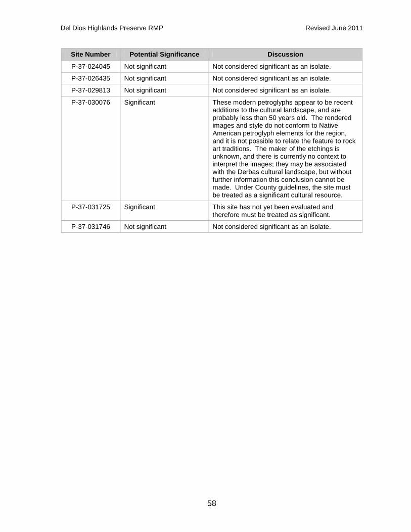
Del Dios Highlands Preserve RMP Revised June 2011
58
Site Number Potential Significance Discussion
P-37-024045 Not significant Not considered significant as an isolate.
P-37-026435 Not significant Not considered significant as an isolate.
P-37-029813 Not significant Not considered significant as an isolate.
P-37-030076 Significant These modern petroglyphs appear to be recent additions to the cultural landscape, and are probably less than 50 years old. The rendered images and style do not conform to Native American petroglyph elements for the region, and it is not possible to relate the feature to rock art traditions. The maker of the etchings is unknown, and there is currently no context to interpret the images; they may be associated with the Derbas cultural landscape, but without further information this conclusion cannot be made. Under County guidelines, the site must be treated as a significant cultural resource.
P-37-031725 Significant This site has not yet been evaluated and therefore must be treated as significant.
P-37-031746 Not significant Not considered significant as an isolate.
Del Dios Highlands Preserve RMP Revised June 2011
59
5.0 RESOURCE MANAGEMENT 5.1 Management Goals and Objectives Management of the natural and cultural resources within the Preserve will be guided by the goals and objectives of both the County and the MSCP. 5.1.1 County-Specific County-specific goals and objectives used to guide the management of resources within the Preserve can be found in the County Strategic Plan, the DPR Strategic Plan, and the San Diego County General Plan (including the San Dieguito Community Plan and the North County Metropolitan Subregional Plan). The County’s overall goal or mission, as indicated in the 2009-2014 Strategic Plan, is to provide the residents of San Diego County with superior County services in terms of quality, timeliness and value in order to improve the region’s quality of life. The Strategic Plan for Parks and Recreation is closely aligned with the County’s strategic initiatives. The DPR Strategic Plan 2008-2013, outlines the department’s priorities for accomplishing its mission over a five-year period. The overall goal or mission of DPR is to provide opportunities for high quality parks and recreation experiences and to preserve regionally significant natural and cultural resources. DPR makes this mission a reality through programs that create healthy communities, protect valuable natural and cultural resources, provide recreation opportunities, reduce crime and vandalism, and foster economic development. In addition, County-specific goals and guidelines can be found in the San Diego County General Plan. Specifically, the Preserve is located within areas covered by the San Dieguito Community Plan and the North County Metropolitan Subregional Plan. These plans have goals to provide a system of open space to preserve and protect environmental resources including archaeological resources and unique natural elements. In addition, the San Dieguito Community Plan designates the portion of Escondido Creek within the Preserve as a Resource Conservation Area. 5.1.2 MSCP-Related The MSCP Plan, the South County Subarea Plan and the North County Plan provide general and core area-specific goals. The Preserve is comprised of parcels included in both the Hodges Reservoir/San Pasqual Valley Core Area of the South County MSCP North Metro-Lakeside-Jamul Segment, and the Harmony Grove Core Area of the North County MSCP. The overall MSCP goal is to maintain and enhance biological diversity in the region and conserve viable populations of endangered, threatened, and key sensitive species and their habitat, thereby preventing local extirpation and ultimate extinction.

Del Dios Highlands Preserve RMP Revised June 2011
60
Specific conservation goals for the Hodges Reservoir/San Pasqual Valley Core Area include the following:
• Maximize habitat structural diversity of conserved habitat areas, including conservation of unique habitats and features.
• Provide for conservation of extensive patches of coastal sage scrub and other habitat types that were ranked as having high and very high biological value.
• Minimize impacts to narrow endemic species and avoid impacts to core populations of narrow endemic species.
Specific conservation goals for the Harmony Grove Core Area include the following:
• Protect Encinitas baccharis, including different genders to ensure reproductive capability, and wart-stem lilac, particularly dense stands.
• Protect the Escondido Creek floodplain. Conserve riparian and upland habitat along Escondido Creek for water quality and sensitive species, such as least Bell’s vireo. Maintain natural flow regimes to maintain functionality of the San Elijo Lagoon.
• Maintain connectivity, particularly east-west, along Escondido Creek canyon by minimizing roads and maintaining natural habitat. Maintain connectivity through natural lands for wildlife movement of large and medium sized mammals between preserved habitats.
• Remove invasive, non-native species (e.g., Tamarix, Arundo, brown-headed cowbirds, etc.), particularly to enhance habitat quality along Escondido Creek.
5.1.3 Management Directives and Implementation Measures Based on the above goals and objectives, recommended management directives have been identified. The ASMDs provided herein have been designated as Priority 1 or Priority 2. This designation recognizes the fact that many of the directives cannot be immediately implemented, but instead will occur over the life of the MSCP. The ability to implement and the timing of many of the management directives will be directly related to the availability of funding in any fiscal year and on the priority. The priorities are, therefore, intended to assist in decisions on where and how to spend limited funds. Priority designations are as follows:
Priority 1: Directives that protect the resources in the Preserve and the MSCP preserve, including management actions that are necessary to ensure that sensitive species are adequately protected.
Priority 2: Directives other than those required for sensitive species status and other long-term items that may be implemented during the life of the MSCP as funding becomes available.

Del Dios Highlands Preserve RMP Revised June 2011
61
This RMP includes management directives and implementation measures to meet MSCP goals and objectives under the following elements: (A) Biological Resources, (B) Vegetation Management; (C) Public Use, Trails, and Recreation; (D) Operations and Facility Maintenance; and (E) Cultural Resources.
Del Dios Highlands Preserve RMP Revised June 2011
62
5.2 Biological Resources Element (A) 5.2.1 Biological Monitoring Biological monitoring will be performed onsite to gather information that will assist DPR in making land management decisions to conform to MSCP goals and objectives, as well as DPR objectives. The biological monitoring that will occur will be designed to guide decisions at the individual preserve level. Baseline surveys of the Preserve were conducted in 2007-08 and 2010-11 and the results are included in Appendices A and C. On-going monitoring is expected to commence in 2013. Additional monitoring results will be incorporated into stand alone monitoring reports. These reports may recommend revisions to the management directives contained within this RMP. Monitoring at the preserve scale is focused on obtaining information for management purposes, but can be useful for subregional and ecoregional monitoring assessment as well. DPR will monitor the status and trends of MSCP covered species and collect data on key environmental resources within the Preserve to select, prioritize, and measure the effectiveness of management activities. In most instances, the array of threats or stressors on preserved habitats, their mechanisms of action, and the responses of the habitats and associated species are not completely understood at this time. Therefore, ASMDs must comprehensively address resource management issues for each preserve. Information collected within each preserve will be aggregated for analysis at the subregion and ecoregion scales. The key to successful monitoring at the individual preserve level is: close coordination with stakeholder groups that are performing subregional monitoring; sharing of data, future plans and schedules; and keeping abreast of monitoring methods as they are developed. To ensure uniformity in the gathering and treatment of data, a (SANDAG) land management working group (known as the San Diego Monitoring and Management Program) has been formed and has designated a land manager who will assist jurisdictions in coordinating monitoring programs, analyzing data, and providing other information and technical assistance. The County is an active participant in the development of monitoring methods for the MSCP. Once these methods are fully developed, and as feasible, these methods will be adapted for the Preserve. DPR will follow the habitat- and species-specific monitoring requirements outlined in Table 3-5 of the Subregional MSCP Plan (City of San Diego 1998) and/or those proposed in the North County Plan, as appropriate. Additionally, DPR will follow USGS rare plant monitoring protocols (McEachern et al. 2007), San Diego State University habitat and vegetation community monitoring protocols (Deutschman et al. 2009) and USFWS wildlife monitoring protocols (USFWS 2008). These references will assist DPR in developing monitoring methods at the preserve level,

Del Dios Highlands Preserve RMP Revised June 2011
63
as well as the management directives that are identified for specific species in this document. Management Directive A.1 – Conduct habitat monitoring to ensure MSCP goals and DPR objectives are met (Priority 1)
Implementation Measure A.1.1: DPR will conduct habitat monitoring at five-year intervals. On-going monitoring within the Preserve will identify any adverse changes in vegetation community distribution and habitat quality, such as changes from fire, invasion by non-natives or decline of existing species, and indicate if modifications to current management actions are needed. More frequent monitoring may be required following a significant fire within the Preserve. The main product of this monitoring will be a report that will include a discussion of monitoring objectives, monitoring methods to meet those objectives, and an updated vegetation community map.
Implementation Measure A.1.2: DPR will conduct general wildlife and rare plant surveys at five-year intervals utilizing and refining baseline monitoring methods to facilitate trend and distribution status analysis. This information will be included in the monitoring report. Implementation Measure A.1.3: DPR will conduct monitoring for invasive plant species at five-year intervals to assess invasion or re-invasion by invasive, nonnative plants within the Preserve. These surveys will focus on areas where invasive, non-native plants have been detected in the past, but also look for new occurrences in the Preserve. This information will be included in the monitoring report.
Management Directive A.2 – Meet the corridor monitoring requirements of the MSCP (Priority 2) As discussed in Section 3.4.1, the Preserve is a component of a corridor connecting the coast to open space areas in the inland portions of North and East San Diego County. Due to adjacent residential development to the northeast and east, the trend for local movement across the Preserve is likely south to west or east to west if wildlife can cross Del Dios Highway. While corridor monitoring within the Preserve will take place at the preserve-level, it is anticipated that it will provide data for better understanding wildlife movement on a regional scale.
Implementation Measure A.2.1: DPR will conduct corridor monitoring at five-year intervals in conjunction with habitat monitoring, and general wildlife and rare plant surveys (see implementation measures A.1.1 and A.1.2). The scope of monitoring will be sufficient to determine if corridors are being utilized, but not to determine the extent of use (i.e., how many individuals of any given species use a corridor). The results of the assessment of habitat linkage function, including a list of species detected, will be included in the monitoring report.

Del Dios Highlands Preserve RMP Revised June 2011
64
5.2.2 Species-Specific Monitoring and Management Not all species occurring within the Preserve are expected to require species-specific management. It is expected, rather, that the general management directives and implementation measures outlined under the Biological Resources and Vegetation Management elements are sufficient to protect and manage optimal habitat conditions for most, if not all, species to maintain and/or thrive within the Preserve. However, some special-status species, such as MSCP-covered and County-listed species, require additional measures. Table 3-5 of the Subregional MSCP Plan provides specific management and/or monitoring measures that are conditions of coverage for South County MSCP-covered species. In addition, the North County MSCP provides habitat-specific management and monitoring guidelines that will benefit certain covered species for the following habitat types: riparian, marsh and wet meadow habitat; coastal sage scrub, chaparral, and grassland habitat; oak woodlands and coniferous forest; and vernal pools. The North County Framework Resource Management Plan outlines the major factors that are a risk to these specific habitats and discusses management and monitoring to reduce the threats. Additionally, the North County Plan conservation analysis provides species-specific monitoring and management conditions for proposed covered species that may need more specialized management directives. Management Directive A.3 - Comply with applicable conditions of coverage for South County MSCP Covered Species and/or provide management and monitoring of North County MSCP Covered Species (Priority 1) DPR will implement the habitat-based and, in some cases, species-specific monitoring and management conditions and guidelines as outlined in Table 3-5 of the Subregional MSCP Plan and/or the North County Plan for all species within the Preserve that are covered or proposed for coverage under the MSCP.
The conditions of coverage and recommended guidelines for those species currently known to occur in the Preserve are listed below followed by an explanation of how monitoring and management activities in the Preserve will comply. In order to avoid repetition, the following is a list of the common threats/risk factors to habitats and covered species, and the corresponding management directives or implementation measures intended to address these factors.
• Invasive, non-native plants: Management directives B.2 & B.3, and implementation measures A.1.3, B.4.5 & C.5.3
• Invasive, non-native wildlife: Implementation measures A.5.1 & A.5.2
• Fire: Management directive B.4

Del Dios Highlands Preserve RMP Revised June 2011
65
• Human disturbance: Management directives C.1, C.2, C.5, D.7 & D.8, and implementation measures C.4.1 & D.3.3
• Edge effects: Management directives D.7 & D.8, and implementation measures B.4.1 & C.5.3
• Hydrological Management: Management directive D.3. Wart-stemmed Ceanothus (Ceanothus verrucosus) MSCP Coverage: South County & North County Monitoring: Trend Monitoring (Medium Priority) Monitoring efforts include habitat monitoring, general wildlife and rare plant surveys, and monitoring for invasive plant species (see A.1.1, A.1.2 and A.1.3), as well as the species-specific monitoring described in the implementation measure below.
Implementation Measure A.3.1: DPR will conduct surveys of the wart-stemmed ceanothus populations within the Preserve to determine the number, size, variability and health status (e.g., new vegetative growth, flowering). These surveys will also document observations of insect pollinators, the status of invasive species in the vicinity of wart-stemmed ceanothus, and the condition of soils and evidence of soil disturbance. These surveys will be conducted at five-year intervals in conjunction with habitat monitoring.
Management: Table 3-5 Conditions & Population/Habitat Maintenance/Enhancement Table 3-5 states ASMDs must include specific management measures to increase populations, including specific management measures to address the autecology and natural history of the species, and to reduce the risk of catastrophic fire. Wart-stemmed ceanothus was observed throughout the entire Preserve as a common component of the southern mixed chaparral and the population on site is substantial in size (estimated at over 450,000 individuals). Therefore, the management approach for this species is maintenance of the population and suitable habitat (chaparral) within the Preserve, and, when necessary, enhancement. Chaparral habitat will be managed to reduce the threat of fire and invasive, non-native plants. Encinitas Baccharis (Baccharis vanessae) MSCP Coverage: South County & North County Monitoring: Trend Monitoring (High Priority) Monitoring efforts include habitat monitoring, general wildlife and rare plant surveys, and monitoring for invasive plant species (see A.1.1, A.1.2 and A.1.3), as well as the species-specific monitoring described in the implementation measure below.

Del Dios Highlands Preserve RMP Revised June 2011
66
Implementation Measure A.3.2: DPR will conduct surveys of the Encinitas baccharis populations within the Preserve to determine the number, size, variability and health status (e.g., new vegetative growth). These surveys will also document the status of invasive species in the vicinity of Encinitas baccharis, condition of soils, evidence of disturbance, and time period since most recent fire. These surveys will be conducted at five-year intervals in conjunction with habitat monitoring.
Management: Table 3-5 Conditions & Population/Habitat Maintenance/Enhancement The management approach for this species is maintenance of the population and suitable habitat (chaparral) within the Preserve, and, when necessary, enhancement. Chaparral habitat will be managed to reduce the threat of fire and invasive, non-native plants. Table 3-5 states ASMDs must include specific management measures to address the autecology and natural history of the species, measures to reduce the risk of catastrophic fire, and appropriate female/male plant ratios. Encinitas baccharis is likely a fire-adapted species that is enhanced by fire; however, the exact fire-response mechanism is not known (Reiser 1994). The area where the population occurs burned most recently in 1990. However, determining the appropriate fire cycles for reproduction will require evaluating the species response to future fire events as described below.
Implementation Measure A.3.3: DPR will evaluate the distribution of Encinitas baccharis following fire events within the Preserve. Evaluating its response to fires in the Preserve will involve long-term assessment and more than one fire cycle.
Western Spadefoot (Spea hammondii) MSCP Coverage: North County Monitoring: Status Monitoring (Low Priority) Monitoring efforts include habitat monitoring, general wildlife and rare plant surveys, and monitoring for invasive plant species (see A.1.1, A.1.2 and A.1.3). Management: Habitat Maintenance The management approach for this species is maintenance of suitable breeding habitat (riparian/wetlands) and upland foraging and aestivation habitat (oak woodland) along Escondido Creek within the Preserve. These habitats will be managed to reduce the threat of fire and invasive, non-native species, and maintain hydrology.

Del Dios Highlands Preserve RMP Revised June 2011
67
Orange-throated Whiptail (Cnemidophorus hyperythrus beldingi) MSCP Coverage: South County & North County Monitoring: Status Monitoring (Low Priority) Monitoring efforts include habitat monitoring, general wildlife and rare plant surveys, and monitoring for invasive plant species (see A.1.1, A.1.2 and A.1.3). Management: Table 3-5 Conditions & Habitat Maintenance The management approach for this species is maintenance of suitable habitat (chaparral, sage scrub and grassland) within the Preserve. These habitats will be managed to reduce the threat of fire and invasive, non-native species. In addition, management of these habitats also addresses edge effects as a condition of Table 3-5. Coast Horned Lizard (Phyrnosoma coronatum blainvillii) MSCP Coverage: South County & North County Monitoring: Status Monitoring (Low Priority) Monitoring efforts include habitat monitoring, general wildlife and rare plant surveys, and monitoring for invasive plant species (see A.1.1, A.1.2 and A.1.3), as well as monitoring for presence of Argentine ant (see A.5.1). Management: Table 3-5 Conditions & Habitat Maintenance The management approach for this species is maintenance of suitable habitat (chaparral, sage scrub and grassland) within the Preserve. These habitats will be managed to reduce the threat of fire and invasive, non-native species as well as edge effects as a condition of Table 3-5. In addition, Table 3-5 states area-specific management directives must include specific measures to address Argentine ant. Argentine ants are a demonstrated stressor on this species in areas with substantial urban development, which is not typical of this region. No Argentine ants have been documented within the Preserve. . Red Diamond Rattlesnake (Crotalus ruber ruber) MSCP Coverage: North County Monitoring: Status Monitoring (Low Priority) Monitoring efforts include habitat monitoring, general wildlife and rare plant surveys, and monitoring for invasive plant species (see A.1.1, A.1.2 and A.1.3).

Del Dios Highlands Preserve RMP Revised June 2011
68
Management: Habitat Maintenance The management approach for this species is maintenance of suitable habitat (chaparral and sage scrub) within the Preserve. These habitats will be managed to reduce the threat of fire and invasive, non-native species. Two-striped garter snake (Thamnophis hammondii) MSCP Coverage: North County Monitoring: Status Monitoring (Low Priority) Monitoring efforts include habitat monitoring, general wildlife and rare plant surveys, and monitoring for invasive plant species (see A.1.1, A.1.2 and A.1.3). Management: Habitat Maintenance The management approach for this species is maintenance of suitable habitat (riparian/wetlands, chaparral, sage scrub and oak woodland) along Escondido Creek within the Preserve. These habitats will be managed to reduce the threat of fire and invasive, non-native species, and maintain hydrology. Southern California Rufous-crowned Sparrow (Aimophila ruficeps canescens) MSCP Coverage: South County & North County Monitoring: Trend Monitoring (Medium Priority) Monitoring efforts include habitat monitoring, general wildlife and rare plant surveys, and monitoring for invasive plant species (see A.1.1, A.1.2 and A.1.3), as well as the species-specific monitoring described in the implementation measure below.
Implementation Measure A.3.4: DPR will conduct focused surveys of rufous-crowned sparrows to determine the number of populations and the proportion of occupied habitat within the Preserve. These surveys will be conducted at five-year intervals in conjunction with habitat monitoring.
Management: Table 3-5 Conditions & Population/Habitat Maintenance/Enhancement The management approach for this species is maintenance of the population and suitable habitat (chaparral and sage scrub) within the Preserve and, when necessary, enhancement. Chaparral and sage scrub habitats will be managed to reduce the threat of fire and invasive, non-native plants. Table 3-5 states ASMDs must include maintenance of dynamic processes, such as fire, to perpetuate some open phases of coastal sage scrub with herbaceous components. There are only

Del Dios Highlands Preserve RMP Revised June 2011
69
three relatively small areas of coastal sage scrub, totaling approximately 5.05 acres, within the Preserve. Two of these patches burned most recently in 1997 and the other burned in 1943. However, the majority of the chaparral habitat within the preserve has burned multiple times over the years, thus providing open areas needed by this species. Bell’s Sage Sparrow (Amphispiza belli belli) MSCP Coverage: North County Monitoring: Trend Monitoring (Medium Priority) Monitoring efforts include habitat monitoring, general wildlife and rare plant surveys, and monitoring for invasive plant species (see A.1.1, A.1.2 and A.1.3), as well as the species-specific monitoring described in the implementation measure below.
Implementation Measure A.3.5: DPR will conduct focused surveys of Bell’s sage sparrow to determine the number of occupied locations, proportion of occupied habitat, and colonization of unoccupied, restored or recovering (e.g., from wildlife) habitat within the Preserve. These surveys will be conducted at five-year intervals in conjunction with habitat monitoring.
Management: Population/Habitat Maintenance/Enhancement The management approach for this species is maintenance of the population and suitable habitat (chaparral and sage scrub) within the Preserve and, when necessary, enhancement. Chaparral and sage scrub habitats will be managed to reduce the threat of fire and invasive, non-native plants. Cooper’s Hawk (Accipiter cooperii) MSCP Coverage: South County Monitoring: Status Monitoring (Low Priority) Monitoring efforts include habitat monitoring, general wildlife and rare plant surveys, and monitoring for invasive plant species (see A.1.1, A.1.2 and A.1.3). Management: Table 3-5 Conditions & Habitat Maintenance The management approach for this species is maintenance of suitable foraging (upland and riparian habitats) and nesting habitat (oak woodland and riparian forest near water) within the Preserve. These habitats will be managed to reduce the threat of fire and invasive, non-native plants, and maintain hydrology. In addition, management of these habitats will include 300-foot impact avoidance areas around

Del Dios Highlands Preserve RMP Revised June 2011
70
any active nests, and minimization of disturbance in oak woodlands and oak riparian forests as a condition of Table 3-5. Ferruginous hawk (Buteo regalis) MSCP Coverage: South County Monitoring: Status Monitoring (Low Priority) Monitoring efforts include habitat monitoring, general wildlife and rare plant surveys, and monitoring for invasive plant species (see A.1.1, A.1.2 and A.1.3). Management: Habitat Maintenance Table 3-5 does not include any conditions for coverage of this species as it is not known to nest in the South County MSCP Subarea. The management approach for this species is maintenance of suitable foraging habitat (chaparral, sage scrub and grassland) within the Preserve. These habitats will be managed to reduce the threat of fire and invasive, non-native plants. Peregrine Falcon (Falco peregrinus) MSCP Coverage: South County Monitoring: Status Monitoring (Low Priority) Monitoring efforts include habitat monitoring, general wildlife and rare plant surveys, and monitoring for invasive plant species (see A.1.1, A.1.2 and A.1.3). Management: Habitat Maintenance Table 3-5 does not include any conditions for coverage of this species as it is has very low population numbers in the County and all known nesting sites occur outside of the South County MSCP Subarea. The management approach for this species is maintenance of suitable habitat (riparian/wetlands) within the Preserve. These habitats will be managed to reduce the threat of fire and invasive, non-native plants, and maintain hydrology. Northern Harrier (Circus cyaneus) MSCP Coverage: South County & North County Monitoring: Status Monitoring (Low Priority) Monitoring efforts include habitat monitoring, general wildlife and rare plant surveys, and monitoring for invasive plant species (see A.1.1, A.1.2 and A.1.3).
Del Dios Highlands Preserve RMP Revised June 2011
71
Management: Table 3-5 Conditions & Habitat Maintenance The management approach for this species is maintenance of suitable habitat (open sage scrub and grassland) within the Preserve. These habitats will be managed to reduce the threat of fire and invasive, non-native plants. In addition, management of these habitats will include 900-foot impact avoidance areas around any active nests as a condition of Table 3-5. Yellow-breasted Chat (Icteria virens) MSCP Coverage: North County Monitoring: Status Monitoring (Low Priority) Monitoring efforts include habitat monitoring, general wildlife and rare plant surveys, and monitoring for invasive plant species (see A.1.1, A.1.2 and A.1.3). Management: Habitat Maintenance The management approach for this species is maintenance of suitable habitat (riparian woodland) within the Preserve. Riparian woodland will be managed to reduce the threat of fire and invasive, non-native plants, and maintain hydrology. White-faced Ibis (Plegadis chihi) MSCP Coverage: South County & North County Monitoring: Status Monitoring (Low Priority) Monitoring efforts include habitat monitoring, general wildlife and rare plant surveys, and monitoring for invasive plant species (see A.1.1, A.1.2 and A.1.3). Management: None This species was observed flying over the Preserve during the 2007-08 surveys; however, there is not suitable nesting, foraging or roosting habitat within the Preserve. This species was more than likely flying to or from Lake Hodges or the adjacent Olivenhain Reservoir. Therefore, no management is proposed at this time. Coastal California Gnatcatcher (Polioptila californica) MSCP Coverage: South County & North County Monitoring: Trend Monitoring (Medium Priority)

Del Dios Highlands Preserve RMP Revised June 2011
72
Monitoring efforts include habitat monitoring, general wildlife and rare plant surveys, and monitoring for invasive plant species (see A.1.1, A.1.2 and A.1.3), as well as monitoring for cowbird nest parasitism and Argentine ants (see A.5.1). In addition, monitoring efforts will include the species-specific monitoring described in the implementation measure below.
Implementation Measure A.3.6: DPR will conduct focused surveys of California gnatcatcher to determine the number of occupied locations, proportion of occupied habitat, and colonization of unoccupied, restored or recovering (e.g., from wildlife) habitat within the Preserve. These surveys will be conducted at five-year intervals in conjunction with habitat monitoring.
Management: Table 3-5 Conditions & Population/Habitat Maintenance/Enhancement The management approach for this species is maintenance of the population and suitable habitat (coastal sage scrub) within the Preserve and, when necessary, enhancement. Coastal sage scrub will be managed to reduce the threat of edge effects, fire, and invasive, non-native plants. In addition, disturbance to coastal sage scrub will be minimized during the nesting period (February 15 to August 31) and no clearing of occupied habitat will occur between March 1 and August 15 as a condition of Table 3-5. Western Bluebird (Sialia mexicana) MSCP Coverage: South County Monitoring: Status Monitoring (Low Priority) Monitoring efforts include habitat monitoring, general wildlife and rare plant surveys, and monitoring for invasive plant species (see A.1.1, A.1.2 and A.1.3) as well as monitoring for European starling (see A.5.1). Management: Habitat Maintenance Table 3-5 does not include any conditions for coverage of this species as its persistence in the County depends largely on conservation of existing large populations on public lands east of the South County MSCP subarea. The management approach for this species is maintenance of suitable nesting (oak woodland and riparian forest) and foraging habitat (chaparral and grasslands) within the Preserve. These habitats will be managed to reduce the threat of fire and invasive, non-native plants. San Diego Black-tailed Jackrabbit (Lepus californicus benettii) MSCP Coverage: North County

Del Dios Highlands Preserve RMP Revised June 2011
73
Monitoring: Status Monitoring (Low Priority) Monitoring efforts include habitat monitoring, general wildlife and rare plant surveys, and monitoring for invasive plant species (see A.1.1, A.1.2 and A.1.3). Management: Habitat Maintenance The management approach for this species is maintenance of suitable habitat (chaparral, sage scrub and grassland) within the Preserve. These habitats will be managed to reduce the threat of fire and invasive, non-native plants. Southern Mule Deer (Odocoileus hemionus) MSCP Coverage: South County Monitoring: Status Monitoring (Low Priority) Monitoring efforts include habitat monitoring, general wildlife and rare plant surveys, and monitoring for invasive plant species (see A.1.1, A.1.2 and A.1.3) as well as corridor monitoring (see A.2.1). Management: Habitat Maintenance Table 3-5 does not include any conditions for coverage of this species because it is generally not considered sensitive, but is considered an important species to protect for its aesthetic and intrinsic values. The management approach for this species is maintenance of the open space within the Preserve to facilitate large mammal movement. Mountain Lion (Puma concolor) MSCP Coverage: South County & North County Monitoring: Status Monitoring (Low Priority) Monitoring efforts include habitat monitoring, general wildlife (including status of prey populations) and rare plant surveys, and monitoring for invasive plant species (see A.1.1, A.1.2 and A.1.3) as well as corridor monitoring (see A.2.1). Management: Habitat Maintenance Table 3-5 does not include any conditions for coverage of this species because it is generally not considered sensitive, but is considered an important species to protect for its aesthetic and intrinsic values. The management approach for this species is maintenance of the open space within the Preserve to facilitate large mammal movement.

Del Dios Highlands Preserve RMP Revised June 2011
74
Townsend’s Big-eared Bat (Corynorhinus townsendii) MSCP Coverage: North County Monitoring: Status Monitoring (Low Priority) Monitoring efforts include habitat monitoring, general wildlife and rare plant surveys, and monitoring for invasive plant species (see A.1.1, A.1.2 and A.1.3). Management: Habitat Maintenance The management approach for this species is protection and maintenance of suitable roosting habitat (e.g., rock crevices, old buildings, caves and mining shafts) from human disturbance within the Preserve. Management Directive A.4 - Provide management and monitoring of other sensitive species listed on the County’s Sensitive Plant List (Lists A and B) (Priority 1) The Biological Mitigation Ordinance is the implementing ordinance for the MSCP and requires avoidance of narrow endemic plant species as well as species included in Lists A and B of the County’s Sensitive Plant List. List A and B species are considered rare, threatened or endangered in California. The general management directives and implementation measures outlined in this RMP are intended to be adequate for the conservation of these species, and the County will monitor these species to ensure this is the case. Monitoring efforts for List A and List B plants will include the monitoring described in the implementation measure below.
Implementation Measure A.4.1: DPR will conduct surveys of County List A and List B plant species, not covered by the MSCP, within the Preserve including summer holly, Robinson’s pepper-grass and ashy spike-moss. Surveys will document the locations of species populations, and quantify the number of individuals and/or the acreage of these populations. These surveys will be conducted at five-year intervals in conjunction with habitat monitoring.
5.2.3 Non-Native Invasive Wildlife Species Control One of the conservation goals for the Harmony Grove Core Area is the removal of invasive, non-native species. The North County MSCP Plan-wide and habitat-specific management and monitoring guidelines for non-native, invasive species control were used to develop the management directives and implementation measures provided below, which are intended to meet this goal. Management Directive A.5 – Reduce, control or, where feasible, eradicate invasive, non-native fauna known to be detrimental to native species and/or the local ecosystem (Priority 2)

Del Dios Highlands Preserve RMP Revised June 2011
75
As discussed in Section 3.3.4, two invasive, non-native species of management concern were detected within the Preserve during baseline surveys. These include brown-headed cowbird and European starling. These species do not currently appear to be posing an immediate threat to native species and/or the local ecosystem; however, they have potential to outcompete native species for valuable resources.
Implementation Measure A.5.1: DPR will conduct surveys for the presence of invasive, non-native wildlife species of management concern, including cowbirds and European starlings as well as Argentine ants, at five-year intervals in conjunction with habitat monitoring and general wildlife surveys (see A.1.1 and A.1.2). Subsequent surveys will document and monitor the extent of cowbird parasitism on target species nests, if any, in the Preserve.
Implementation Measure A.5.2: If future monitoring indicates that cowbird parasitism is occurring within the Preserve and having a detrimental effect on native bird species, DPR will consider establishing a cowbird trapping program to increase the nesting success of target species.
5.2.4 Future Research The MSCP preserve presents a rich array of research opportunities for the academic and professional communities, primarily in disciplines related to biology, ecology, and natural resources management, but also ranging to environmental design, sociology, and park use and administration. The County of San Diego encourages research within the MSCP preserve in order to gain valuable information unavailable through other means. There are a multitude of unanswered questions posed by the development of a multiple species and habitat system where little literature or previous research exists on the majority of species inhabiting the region. In addition, research on vegetation associations and habitats, natural regeneration, restoration, fragmentation, edge effects, genetics, viability, predation, wildlife movement, and much more, would be useful to provide information on the health and dynamics of this open space system, as well as how to improve conditions. Management Directive A.6 – Allow for future research opportunities within the Preserve (Priority 2)
Implementation Measure A.6.1: DPR will accept and review proposals for scientific research, monitoring, and habitat restoration and enhancement activities, which are permitted within the MSCP Preserve. Proposed research activities will be subject to approval by DPR. All such activities must obtain any necessary permits and shall be consistent with this RMP. Additionally, any person conducting research of any kind within the Preserve shall obtain a Right-

Del Dios Highlands Preserve RMP Revised June 2011
76
of-Entry Permit from DPR, which will outline the precautions to be taken to preserve and protect sensitive biological and cultural resources within the Preserve, and require the results of any research be made available to DPR.
Del Dios Highlands Preserve RMP Revised June 2011
77
5.3 Vegetation Management Element (B) The North County MSCP provides Plan-wide and habitat-specific management and stewardship guidelines for non-native invasive species control, habitat restoration, and fire and vegetation management. In addition, a Vegetation Management Plan (VMP) for the Preserve has been prepared in conjunction with the baseline surveys (Dudek 2011b) and is included as Appendix E. The VMP characterizes current site conditions and details recommended measures for invasive species control, habitat restoration, and fire management within the Preserve. These guidelines and recommendations were used to develop the management directives and implementation measures provided below. 5.3.1 Habitat Restoration Habitat restoration is not typically required by the South County Subarea Plan or the North County Plan, but is encouraged if resources are available. Management Directive B.1 – Restore degraded habitats to protect and enhance populations of rare and sensitive species through stabilization of eroded lands and strategic revegetation (Priority 2) The Preserve is generally composed of high-quality native vegetation communities, and habitat restoration opportunities within the Preserve are limited. However, several areas of disturbed habitat are recommended for passive and active restoration.
Implementation Measure B.1.1: DPR will implement passive restoration methods (e.g., perform weed and erosion control) in proposed restoration areas 4, 6 and 7 (Figure 10) as recommended in the VMP (Dudek 2011b). Since the process of recruitment and establishment of native plant species has already begun, no soil disturbance (e.g., ripping, tilling, grading) or other soil preparation is recommended. Passive restoration areas will be maintained weed free, as feasible, to allow native recruitment to continue until these areas are reincorporated back into the surrounding southern mixed chaparral. Should natural recruitment slow or stop over time, DPR will consider incorporation of active restoration in these areas including seed application or installation of container plants. Implementation Measure B.1.2: DPR will implement active restoration methods (e.g., soil preparation, seed application and installation of container plants) in proposed restoration areas 1-3, 5, and 8-13 (Figure 10) as recommended in the VMP (Dudek 2011b). Any plant materials will be native species from San Diego County, preferably originating within 25 miles of the Preserve. Quantities, rates and composition of seed mixes or planting palettes will be determined on an individual basis, based on the existing plant composition surrounding the restoration sites.

Del Dios Highlands Preserve RMP Revised June 2011
78
5.3.2 Non-Native Invasive Plant Species Removal and Control One of the conservation goals for the Harmony Grove Core Area is the removal of invasive, non-native species to enhance habitat quality. The following management directives and implementation measures are intended to meet this goal. In addition, non-native, invasive plant removal serves the dual purpose of vegetation thinning for fire suppression. Management Directive B.2 – Reduce, control, or where feasible eradicate invasive, non-native flora known to be detrimental to native species and/or the local ecosystem (Priority 1) As described in Section 3.2.4, 10 Cal-IPC rated invasive, non-native plant species were identified within the Preserve. These species were ranked for removal priority (high, moderate and low) in the VMP to assist management efforts within the Preserve.
Implementation Measure B.2.1: DPR park rangers will routinely pull weeds or remove any invasive, non-native plant species in early stages of growth observed along trails or access roads. Implementation Measure B.2.2: DPR will coordinate with other agencies, non-profit organizations, and/or volunteer groups in order to seek funding and implement invasive, non-native plant removal projects within the Preserve. Precedence will be given to those species identified as high priority, followed by moderate and then low priority species. See also B.4.5.
Management Directive B.3 – Manage and minimize the expansion of invasive, non-native flora within the Preserve (Priority 2)
Implementation Measure B.3.1: DPR will implement an educational program for Preserve visitors and adjacent residents in order to discourage introduction of invasive, non-native plants into the Preserve. Provided information will discuss invasive plants harmful to the Preserve, and prevention methods. The program may also encourage residents to voluntarily remove invasive, non-native plants from their landscaping. See also D.8.1.
5.3.3 Fire Prevention, Control and Management As described in Section 2.3.4, the Preserve is classified as a Very High Fire Hazard Severity Zone by CAL FIRE (FRAP 2011) and is located within the Rancho Priority Area for fuel management as identified by the Forest Area Safety Task Force (County 2009c). Current fire management activities in the Preserve include the fuel modification zones described below:

Del Dios Highlands Preserve RMP Revised June 2011
79
• Defensible space along the northern and northeastern borders of the
Preserve where the Preserve abuts residential development (fuel modification in these areas provide the adjacent residences a 100-foot buffer as measured from the residential structures).
• 30-foot fuel modification zone from the right-of-way of Del Dios Highway along the entire eastern border of the Preserve.
• 30-foot fuel modification zone from the right-of-way of Mount Israel Road
along the southern border of the Preserve.
• 30-foot fuel modification zone around the perimeter of the main entrance road and staging area.
The intent of the fuel modification zones is to protect habitable structures within and adjacent to the Preserve from wildfires and provide for safe access for fire agency vehicles and crew when responding to a fire within the Preserve. These areas may further protect the resources within the Preserve by absorbing some of the “edge effects” that might otherwise occur within the Preserve. In the event of a fire, the designated multi-use trail through the north central portion of the Preserve serves as an access road that can be used for emergency response. Management Directive B.4 – Provide for necessary fire management activities that are sensitive to natural and cultural resources protection (Priority 1)
Implementation Measure B.4.1: Park ranger staff will maintain, and extend where necessary, the established fuel modification zones on Preserve property adjacent to the existing residential structures within 100 feet of the Preserve boundary, along the Del Dios Highway and Mount Israel Road right-of-ways, and along the main entrance road and staging area. Management of the fuel modification zone and defensible space will adhere to CAL FIRE, Rancho Santa Fe Fire Protection District, Elfin Forest/Harmony Grove Fire Department, and Escondido Fire Department requirements.
Implementation Measure B.4.2: Park ranger staff will install and maintain inconspicuous fuel modification extent markers for all fuel modification zones to minimize additional thinning outside the intended areas and protect adjacent sensitive resources. Implementation Measure B.4.3: Park ranger staff will maintain the designated multi-use trail that serves as an access road, as needed, to remove fuels and maintain a 10- to 20-foot-wide travel surface in order to facilitate emergency response and access. See also C.5.1.
Del Dios Highlands Preserve RMP Revised June 2011
80
Implementation Measure B.4.4: Park ranger staff will coordinate with SDG&E to conduct fuel reduction (especially non-native trees) beneath the high voltage electrical transmission lines that cross the Preserve, and along utility line access roads to reduce the likelihood of ignitions and fire spread.
Implementation Measure B.4.5: DPR will coordinate with other agencies, non-profit organizations, and/or volunteer groups in order to seek funding and implement non-native, invasive plant removal projects for priority species that pose fire hazards within the Preserve. See also B.2.2.
Implementation Measure B.4.6: DPR will continue to coordinate with CAL FIRE, the Rancho Santa Fe Fire Protection District, Elfin Forest/Harmony Grove Fire Department, and Escondido Fire Department to ensure that the fire response and implementation measures outlined in this RMP and in the VMP (Dudek 2011b) are up-to-date and adequate for effective fire response within the Preserve. As part of this effort, DPR will review fire history maps at least once every 10 years to determine if Preserve lands are within natural fire return intervals and for estimation of fuel age class.

Del Dios Highlands Preserve RMP Revised June 2011
81
5.4 Public Use, Trails, and Recreation Element (C) 5.4.1 Public Access Management Directive C.1 – Limit types of public uses to those that are appropriate for the Preserve (Priority 1)
Implementation Measure C.1.1: Park ranger staff will enforce the following prohibited public uses and restrictions within the Preserve. Park rangers may call the sheriff for legal enforcement, as appropriate.
a. Off-road or cross-country vehicle and public off-highway recreational vehicle activity (except for law enforcement, Preserve management, and/or emergency purposes)
b. Hunting or discharge of firearms (except for law enforcement, and/or emergency purposes)
c. Poaching, collecting or otherwise adversely impacting plant or animal
species, and archaeological or historical features, artifacts or fossils.
d. Fishing, swimming, and wading in rivers, streams, or creeks
e. Camping (including homeless and itinerant worker camps)
f. Feeding wildlife
g. Domestic animals, except horses and leashed dogs
h. Smoking
i. Campfires/Open Flames
j. Off-trail biking, equestrian use, or hiking
k. Littering
Implementation Measure C.1.2: Park ranger staff will ensure that prohibited uses are clearly specified on kiosks, signage and/or trail maps.
Management Directive C.2 – Manage public access in sensitive biological and cultural resource areas within the Preserve (Priority 1)
Implementation Measure C.2.1: DPR has identified and mapped sensitive vegetation communities, plant and wildlife species, and cultural sites in the Preserve so that these areas can be avoided and/or monitored. Updated information on sensitive resources in relation to public access areas will be obtained in conjunction with routine monitoring activities (see A.1.1 and A.1.2).

Del Dios Highlands Preserve RMP Revised June 2011
82
Implementation Measure C.2.2: DPR will provide sufficient signage to clearly identify public access areas within the Preserve. In areas where adverse effects to sensitive resources are observed, DPR will implement measures to restrict public access in order to protect highly sensitive areas. Measures may include barriers such as vegetation, rocks/boulders or fencing. The appropriate types of barriers to be used will be determined based on location, setting and use.
Management Directive C.3 – Provide appropriate interpretive and educational materials (Priority 2)
Implementation Measure C.3.1: DPR will share outreach and educational information, and notify the public of volunteer opportunities that advance the management, monitoring, and stewardship resources available, and objectives of this RMP. This information will be provided on the DPR website, www.sdparks.org. Implementation Measure C.3.2: DPR will identify opportunities for educational trail-side signage and educational kiosks within the Preserve. In addition, signage provided at access points and on trails maps provides a form of education. The use of signs that attract attention to sensitive species or cultural resources will be limited so as to not invite disturbance. See also E.2.3 and E.3.1.
Management Directive C.4 – Analyze any future proposed public access such that recreational use of the Preserve is consistent with the protection and enhancement of biological and cultural resources (Priority 2)
Implementation Measure C.4.1: If, in the future, it is decided to open additional areas of the Preserve to the public, DPR will develop a comprehensive Public Access Plan to determine the appropriate level of public access and recreational use within the Preserve, and provide recommendations for preferred trail alignments and features compatible with the protection and enhancement of biological and cultural resources. DPR will ensure that any proposed trail system is compatible with the MSCP and the County-approved Community Trails Master Plan (County 2009a). Implementation Measure C.4.2: DPR will explore opportunities for public access and viewpoints at the Derbas house site and ensure that any new public-use trails are designed and constructed to avoid and/or minimize impacts to sensitive biological and cultural resource areas. Implementation Measure C.4.3 DPR will ensure that any future proposed trails will undergo environmental review in accordance with CEQA prior to public use of the Preserve.

Del Dios Highlands Preserve RMP Revised June 2011
83
5.4.2 Fencing and Gates There are existing gates located on the eastern and western boundaries of the Preserve (Figure 7) and fencing along the southern boundary. Management Directive C.4 – Install and maintain fencing and gates within the Preserve (Priority 1)
Implementation Measure C.4.1: Park ranger staff will install fencing and/or gates as needed to restrict unauthorized access and protect particularly sensitive resources from impacts. Points of unauthorized public access and sensitive resource impacts will be identified in conjunction with routine monitoring activities (see A.1.1 and A.1.2). DPR will ensure that any fences or gates will be designed and located so they do not impede wildlife movement or impact cultural resources. Implementation Measure C.4.2: Ranger staff will regularly inspect and maintain all fencing and gates within the Preserve. Fencing segments and gates will be repaired or replaced as necessary.
5.4.3 Trail and Access Road Maintenance As described in Section 2.3.4, the designated 1.5-mile multi-use trail, which also serves as an access road, originates at the main entrance and staging area off Del Dios Highway in the east and extends west through the north central portion of the Preserve ultimately providing a western connection to the adjacent Elfin Forest Recreational Reserve trail system and an OMWD maintenance road. Management Directive C.5 – Properly maintain access roads, staging areas and trails for user safety, to protect natural and cultural resources, and to provide high-quality user experiences (Priority 1)
Implementation Measure C.5.1: Park ranger staff will monitor access roads, staging areas, and trails for degradation and off-trail access and use. If necessary, park ranger staff will provide necessary repair/maintenance in accordance with the Community Trails Master Plan (County of San Diego 2009a). See also B.4.3. Implementation Measure C.5.2: If temporary closure of a trail is deemed necessary for maintenance or remediation, temporary closure actions will be accompanied by educational support, and public notification through signs and/or public meeting announcements. An implementation schedule will be written by DPR Operations staff when maintenance or remediation is deemed necessary. The trail will be posted with signage that indicates temporary closure and the primary reason for the temporary closure (e.g., erosion issues, sensitive

Del Dios Highlands Preserve RMP Revised June 2011
84
biological resource impacts). Finally, signs will provide contact information for anyone wishing to provide input on trail use or gain additional information regarding temporary closure of trails. Once posted, the trails in need of maintenance will be blocked with A-frame barricades and/or caution tape. Enforcement of the temporary closure of a trail will require increased ranger patrols of these areas and investigations to determine if the barriers are effective. Implementation Measure C.5.3: DPR will restore degraded habitats, control non-native plant species along trails, and reduce detrimental edge effects through spot treatment of non-native plants, maintenance and stabilization of trails, and strategic revegetation. Measures to counter the effects of trail erosion may include the use of stone or wood cross-joints, edge plantings of native grasses, and mulching of the trail in accordance with the Community Trails Master Plan (County of San Diego 2009a). See also B.1.1 and B.1.2. Implementation Measure C.5.4: If unauthorized trail formation is observed by park ranger staff, those specific areas will be posted with clear signage reminding the public to remain on authorized trails.
5.4.4 Signage Management Directive C.6 – Install, and maintain appropriate signage to effectively communicate important information to Preserve visitors (Priority 1) Current posted signs include the following rules and regulations: Off-roading and ATV Vehicles Prohibited 41.130; Dogs on Leash At All Times 41.123(c); Weapons and Fireworks Prohibited 41.117; All Plants and Animals Are Protected 41.111 and 41.112; Campfire or Open Flames Prohibited 41.118; and Yield to Trail Users Obey Posted Speed Limit.
Implementation Measure C.6.1: Park ranger staff will regularly inspect and maintain all posted signs within the Preserve in good condition. Signs shall be kept free from vandalism and will be repaired or replaced as necessary.
Del Dios Highlands Preserve RMP Revised June 2011
85
5.5 Operations and Facility Maintenance Element (D) 5.5.1 Litter/Trash and Materials Storage Management Directive D.1 – Maintain a safe and healthy environment for Preserve users (Priority 1)
Implementation Measure D.1.1: Park ranger staff will maintain the trash receptacles provided at the main entrance and staging area. The trash receptacles are designed to be secure from intrusion by wildlife species. Park ranger staff will regularly empty trash receptacles at least twice a week or more/less as deemed necessary. Implementation Measure D.1.2: DPR will prohibit the permanent storage of hazardous and toxic materials within the Preserve. Any temporary storage must be in accordance with applicable regulations, and otherwise designed to minimize any potential impacts.
Management Directive D.2 – Publicize and enforce regulations regarding littering/dumping (Priority 1)
Implementation Measure D.2.1: DPR will ensure that regulations regarding littering/dumping (County Code of Regulatory Ordinance Section 41.116) are clearly posted (e.g., on kiosks and at staging area) and enforced within the Preserve. Penalties for littering and dumping will be imposed by law enforcement officers sufficient to prevent recurrence and reimburse costs to remove and dispose of debris, restore the area if needed, and pay for additional DPR staff time. Areas where dumping recurs will be evaluated for potential barrier placement. Additional monitoring and enforcement will be provided as needed.
5.5.2 Hydrological Management Conservation goals for the Harmony Grove Core Area include protecting the Escondido Creek floodplain; conserving riparian and upland habitat along Escondido Creek for water quality and sensitive species; and maintaining natural flow regimes to maintain functionality of the San Elijo Lagoon. The North County Plan habitat-specific hydrology management and monitoring guidelines were used to develop the management directives and implementation measures provided below, which are intended to meet these goals. Management Directive D.3 – Retain Escondido Creek and floodplain in its natural condition (Priority 1)
Implementation Measure D.3.1: DPR will review the data resulting from the County Watershed Protection Program, which monitors water quality throughout

Del Dios Highlands Preserve RMP Revised June 2011
86
the County annually for pollutants that are likely to be delivered from nearby land use, to identify any potential water quality concerns within the Preserve. Implementation Measure D.3.2: DPR will conduct visual assessments of the Escondido Creek channel conditions in conjunction with habitat monitoring (see A.1.1). Where channel conditions are considered poor (e.g., unstable banks), follow up surveys will be conducted to determine if management actions are necessary. Currently, OMWD and the County of San Diego Flood Control District hold a conservation easement and flowage easement, respectively, over Escondido Creek. Where necessary, DPR will coordinate with these agencies to determine appropriate measures to stabilize banks and control erosion. Implementation Measure D.3.3: Park ranger staff will inspect for off-trail access and use along the City of Escondido sewer easement and access road south of Escondido Creek during regular patrols and monitoring (see C.5.1). If necessary, DPR will coordinate with the City of Escondido to implement measures to control public access along the sewer easement, such as installation of signage, access road management and increased patrols, as necessary.
Implementation Measure D.3.4: DPR shall close the Preserve after heavy rains that cause Escondido Creek to flood in conjunction with closures of the adjacent Elfin Forest Recreational Reserve. DPR shall re-open the Preserve at the time Elfin Forest Recreational Reserve re-opens.
5.5.3 Emergency, Safety and Police Services Management Directive D.4 – Cooperate with public health and safety personnel to achieve their goals while helping to reduce or eliminate impacts to biological and cultural resources within the Preserve (Priority 1)
Implementation Measure D.4.1: DPR will allow law enforcement officials and all medical, rescue and other emergency services to access Preserve property as necessary to enforce the law and carry out operations necessary to protect the health, safety, and welfare of the public. DPR will coordinate with the applicable agencies to inform field personnel of the locations of particularly sensitive biological and significant cultural resources and how to minimize damage to these resources. Implementation Measure D.4.2: DPR will maintain the existing local fire agency locks on all Preserve gates. DPR ranger staff will report any removed or missing locks to the appropriate fire agency.
Management Directive D.5 – Provide for a safe recreational experience for Preserve visitors (Priority 1)

Del Dios Highlands Preserve RMP Revised June 2011
87
Implementation Measure D.5.1: In the event of a natural disaster, such as a fire or flood, DPR shall evacuate the Preserve and coordinate with the Emergency Operations Center. In addition, staff will coordinate with the local agency in charge of responding to the emergency and, if possible, assist where necessary.
5.5.4 Adjacency Management Issues As described in Section 2.4.2, the Preserve abuts large areas of conserved open space owned and/or managed by the Water Authority and OMWD as well as the County’s Escondido Creek Preserve. The lands owned by the Water Authority and are covered under the Water Authority’s Subregional NCCP/HCP, which was designed to be compatible with other conservation plans in the region (Water Authority and USFWS 2010). Management Directive D.6 – Coordinate with adjacent landowners and open space land managers (Priority 1)
Implementation Measure D.6.1: DPR will coordinate with the Water Authority and OMWD as the adjacent open space landowners and land managers on an annual basis, or more regularly as needed, to ensure the contiguous preserved habitat is managed consistently and in accordance with the MSCP and Water Authority Subregional NCCP/HCP.
Management Directive D.7 - Enforce Preserve boundaries (Priority 1)
Implementation Measure D.7.1: DPR and park ranger staff will enforce, prevent, and remove illegal intrusions into the Preserve (e.g., orchards, decks) on an annual basis, in addition to a complaint basis.
Management Directive D.8 – Educate residents in surrounding areas about Preserve adjacency issues (Priority 2)
Implementation Measure D.8.1: DPR will post this RMP on the DPR website (www.sdparks.org) to inform surrounding residents of Preserve adjacency issues including access, appropriate landscaping, construction or disturbance within the Preserve boundaries, pet intrusion, and fire management. See also B.3.1.
Del Dios Highlands Preserve RMP Revised June 2011
88
5.6 Cultural Resources Element (E) The goal of this section of the RMP is long-term preservation and public interpretation of cultural resources, and interaction with bands of Native Americans in whose traditional tribal territory this Preserve exists. Management Directive E.1 – Identify, record, and assess the significance of any new cultural resources discovered within the Preserve (Priority 1) As noted in the archaeological survey reports (Hector and Akyüz 2008, ASM 2011), a substantial portion of the Preserve exceeds 20 percent slope and the majority of the terrain is densely vegetated, which largely precluded surveys in these areas. Resources may possibly exist in these unsurveyed areas. If future ground disturbing activities are proposed in these areas, significant adverse effects on potentially significant unknown resources could occur.
Implementation Measure E.1.1: DPR will identify and record cultural resource sites in previously unsurveyed areas of the Preserve where, if in the future, brush is removed as a result of wildfire or planned ground disturbing activities, including clearing, grubbing or new trail development efforts. Any cultural materials collected from the Preserve will be curated at a qualified curation facility. No removal or modification of cultural resources shall occur without written approval by the Director of Parks and Recreation.
Management Directive E.2 – Preserve and protect significant cultural resources to ensure that sites are available for appropriate uses by present and future generations (Priority 2) Potential impacts to cultural resources within the Preserve are most likely to result from fire suppression and maintenance activities, especially vegetation clearing and grading for fire breaks, and from use of roads by the public for hiking, biking and equestrian use. In order to protect these resources, it is necessary that impacts be prevented, reduced, eliminated, or adverse effects mitigated.
Implementation Measure E.2.1: DPR will provide maps of sensitive cultural resources with sufficient buffer around them within the Preserve to the local fire agencies for inclusion in their wildland pre-response plans so that these resources can be avoided to the maximum extent possible. Implementation Measure E.2.2: All management activities within the Preserve including, but not limited to, routine maintenance and habitat restoration, will take into consideration potential impacts to cultural resources and shall avoid adverse impacts to any cultural resources to the maximum extent possible. No ground disturbing activities will be allowed on or in any cultural resource site within the Preserve until the impacts have been assessed.

Del Dios Highlands Preserve RMP Revised June 2011
89
If avoidance is not feasible, appropriate mitigation measures will be established in conjunction with consultation with local Native American tribes. Removal or disturbance of cultural resources shall not occur prior to completion of an approved mitigation program, such as data recovery and a grading monitoring program consisting of a County approved consultant and Native American representative. Preservation in place is the preferred mitigation measure. If human remains are discovered, the County Coroner shall be contacted. In the event that the remains are determined to be of Native American origin, the Most Likely Descendant, as identified by the Native American Heritage Commission, shall be contacted in order to determine proper treatment and disposition of the remains. Mitigation measures will be developed on a case by case basis by the County archaeologist and the archaeological consultant. Implementation Measure E.2.3: Signs shall be posted at kiosks, trail heads and/or throughout the Preserve to notify users that sensitive cultural resources within the Preserve cannot be damaged and that removal of any archaeological material is prohibited by law. Protection and preservation of cultural resources is provided by County of San Diego ordinances (Title 4; Public Property, Division 1; Parks and Beaches, Article 2, Section 41.113), and applicable state and federal laws. The use of signs that attract attention to significant cultural resources will be limited so as to not invite disturbance. Implementation Measure E.2.4: DPR will ensure that park ranger staff has sufficient training through the DPR Ranger Academy to actively protect cultural resource sites from vandalism and other forms of human impact. If a person(s) is suspected of vandalism to cultural resources, the appropriate law enforcement authorities shall be notified. More aggressive measures may be needed if vandalism and damage continue or increase.
Implementation Measure E.2.5: The condition and status of known cultural resources on site shall be noted as part of routine monitoring activities conducted on a five-year basis (or on a more frequent basis as determined by DPR) and remedial measures shall be taken if damage is noted. Monitoring activities should also photo-document site conditions so that comparisons can be made over time. Any monitoring of the sites in the Preserve will follow County guidelines (County 2007). All site location information will be kept strictly confidential, and will be available only for qualified cultural resource staff and land managers. Site locations will not be shown on maps or divulged to the public.
Management Directive E.3 – Promote the beneficial uses of cultural resources through interpretation and educational programs (Priority 2)
Del Dios Highlands Preserve RMP Revised June 2011
90
Implementation Measure E.3.1: Off-site, and when possible, on-site interpretive programs for Native American heritage, local and regional history, and prehistory will be developed for the Preserve. These may include lectures, walks, kiosks, signs, historic brochures, and displays, but will not include excavations, collecting of artifacts, or disclosure of confidential site locations unless an interpretive plan is developed and approved by the Director of Parks and Recreation. The plan will include supervision by a qualified archaeologist approved by the Director of Parks and Recreation. See also C.3.1 and C.3.2.
Management Directive E.4 – Honor Native American Heritage and promote Native American ceremonies, gathering, and cultural practices (Priority 2)
Implementation Measure E.4.1: DPR will continue to coordinate and consult with tribal representatives who may have knowledge of the Preserve area, including those representing the Pala Band of Mission Indians and the San Pasqual Band of Diegueño Mission Indians, in order to keep them informed of activities associated with the Preserve. Consultation shall be conducted frequently in order to identify appropriate management of pre-contact and ethnographic cultural resources. The tribes will be encouraged to participate in surveys, evaluation, recordation, protection and preservation of cultural resources.
Implementation Measure E.4.2: DPR will open the Preserve to traditional uses by the Pala Band of Mission Indians and the San Pasqual Band of Diegueño Mission Indians, as well as other tribes which may have traditionally used the Preserve area. All activities by Native Americans in the Preserve shall be conducted with a Right-of-Entry permit specifically designed for the Preserve.

Del Dios Highlands Preserve RMP Revised June 2011
91
6.0 REFERENCES AOU (American Ornithologists' Union). 1998. Checklist of North American birds. 7th
ed. Washington, DC: American Ornithologists' Union. ASM (ASM Affiliates, Inc.). 2011. Archaeological Survey Report for the Pascoe,
Helix-Lambron, and Cielo Azul Parcel Additions to the Del Dios Highlands Preserve, San Diego County California. Prepared for the County of San Diego Department of Parks and Recreation.
Bartholomew, G. A., Jr. 1943. The daily movements of comorants on San Francisco
Bay. Condor 45:3-18. Best, T. L., W. M. Kiser, P. W. Freeman. 1996. Eumops perotis. Mammalian Species
No. 534. American Society of Mammalogists; 1-8. Bolger, D. T., T. A. Scott, and J. T. Rotenberry. 1997. Breeding bird abundance in an
urbanizing landscape in coastal southern California. Conservation Biology, 11: 406-421.
Bolster, B. C. 1998. Western red-bat, Lasiurus blossevillii. In: Ecology, conservation
and management of western bat species: Bat species accounts. Unpublished document distributed at the Western Bat Working Group Meeting, February 9-13, 1998, Reno, NV.
Bull, E. L. and C. T. Collins. 1993. Vaux's Swift (Chaetura vauxi). In: Poole, A; Gill,
F., eds. The birds of North America. No. 77. Philadelphia, PA: The Academy of Natural Sciences and Washington, DC: The American Ornithologists' Union.
Burhans, D. E., F. R. Thompson, III. 1999. Habitat patch size and nesting success of
Yellow-breasted Chats. Wilson Bull. 111: 210–215. CDFG (California Department of Fish and Game). 2005. California Wildlife Habitat
Relationships System (CWHR), version 8.1 personal computer program. Sacramento, CA: California Department of Fish and Game.
Cal-IPC (California Invasive Plant Council). 2006. California Invasive Plant
Inventory. Cal-IPC Publication 2006-02. California Invasive Plant Council. Berkely, CA. Available at: http://www.cal-ipc.org/ip/inventory/weedlist.php
CNPS (California Native Plant Society). 2010. Inventory of Rare and Endangered
Plants (online edition, c7-10dec). California Native Plant Society, Sacramento. Available at: http://cnps.site.aplus.net/cgi-bin/inv/inventory.cgi
CaliforniaHerps. 2009. California Reptiles and Amphibians. Accessed December
2009: http://www.californiaherps.com/index.html
Del Dios Highlands Preserve RMP Revised June 2011
92
City of San Diego. 1998. Final Multiple Species Conservation Program: MSCP Plan. County (County of San Diego). 1997. Multiple Species Conservation Program:
County of San Diego Subarea Plan. ———. 1998. Implementing Agreement by and between United States Fish and
Wildlife Service, California Department of Fish and Game, County of San Diego. ———. 2001. Framework management plan for the Multiple Species Conservation
Program (MSCP) South County Subarea Plan. ———. 2007. County of San Diego Guidelines for Determining Significance, Cultural
Resources: Archaeological and Historic Resources. Available at: http://www.co.san-diego.ca.us/dplu/docs/Cultural_Guidelines.pdf
———. 2009a. County Trails Program: Community Trails Master Plan. 2005,
updated 2009. Available at: http://www.co.san-diego.ca.us/reusable_components/images/parks/doc/tocrev.pdf
———. 2009b. Multiple Species Conservation Program: Draft North County Plan.
San Diego County. Available at: http://www.sdcounty.ca.gov/dplu/mscp/docs/Plan_Appendices.pdf
———. 2009c. Vegetation Management Report: A Report on Vegetation
Management in the Unincorporated Area of San Diego County. Available at: http://www.sdcounty.ca.gov/dplu/mscp/FINAL_VEGETATION_MGMT_PLAN.pdf
———. 2010b. County of San Diego Guidelines for Determining Significance,
Biological Resources. Available at: http://www.co.san-diego.ca.us/dplu/docs/Biological_Guidelines.pdf
Dudek. 2011a. Baseline Biodiversity Survey for the Pascoe, Helix-Lambron and
Cielo Azul Parcel Additions to the Del Dios Highlands Preserve. Prepared for the County of San Diego Department of Parks and Recreation. May 2011.
———. 2011b. Del Dios Highlands Preserve Vegetation Management Plan.
Prepared for the County of San Diego Department of Parks and Recreation. May 2011.
Dunn, J. and K. Garrett. 1997. A field guide to the warblers of North America. New
York, NY: Houghton Mifflin Company. FRAP (Fire and Resource Assessment Program). 2011. California Department of
Forestry and Fire Protection. Available at: http://frap.cdf.ca.gov/

Del Dios Highlands Preserve RMP Revised June 2011
93
Garrett, K. and J. Dunn. 1981. Birds of southern California. Los Angeles, CA: Los Angeles Audubon Society.
Harvey, M. J., J. S. Altenbach, T. L. Best. 1999. Bats of the United States. Arkansas:
Arkansas Game and Fish Commission. Hector, Susan and Linda Akyüz. 2008. Management Plan for Archaeological
Resources within the Del Dios Highlands Preserve, San Diego County. Prepared for the County of San Diego Department of Parks and recreation.
Holland, R.F. 1986. Preliminary Descriptions of the Terrestrial Natural Communities
of California. State of California Department of Fish and Game, Non-game Heritage Program, Sacramento.
Jennings, M. R. and M. P. Hayes. 1994. Amphibian and reptile species of special
concern in California. Final report to the California Department of Fish and Game, Inland Fisheries Division, Rancho Cordova, CA.
Jepson Flora Project. 2011. Jepson Online Interchange. Accessed January 2011.
http://ucjeps.berkeley.edu/interchange.html Kennedy, M. and S. Tan under California Department of Conservation. 2005.
Geologic Map of the Oceanside 30' X 60' Quadrangle. U.S. Geological Survey, Department of Earth Sciences, University of California, Riverside. Available at: ftp://ftp.consrv.ca.gov/pub/dmg/rgmp/Prelim_geo_pdf/oceanside_map2_ai9.pdf
Kirk, David A. and Michael J. Mossman. 1998. “Turkey Vulture (Cathartes aura),”
The Birds of North America Online (A. Poole, Ed.). Ithaca: Cornell Lab of Ornithology; Retrieved from the Birds of North America Online: http://bna.birds.cornell.edu/bna/species/339doi:10.2173/bna.339
Lackey, J. A. 1996. Chaetodipus fallax. Mammalian Species 517: 1–6. Lemm, J.M. 2006. Field Guide to Amphibians and Reptiles of the San Diego Region.
University of California Press, Berkeley. Lovio, J. C. 1996. The effects of habitat fragmentation on the breeding-bird
assemblage in California coastal sage scrub. M.S. thesis, San Diego State University.
Lowther, P. E., C. Celada, N. K. Klein, C. C. Rimmer, D. A. Spector. 1999. Yellow
warbler (Dendroica petechia). In: Poole, A.; Gill, F., eds. The birds of North America, No. 454. Philadelphia, PA: The Birds of North America, Inc. and Washington, DC: The American Ornithologists' Union.

Del Dios Highlands Preserve RMP Revised June 2011
94
McEachern, K., B. Pavlik, J. Rebman, and R. Sutter. 2007. San Diego Multiple Species Conservation Program Rare Plant Monitoring Review and Revision. Technical report prepared for the City of San Diego.
Marti, Carl D., Alan F. Poole and L. R. Bevier. 2005. “Barn Owl (Tyto alba),” The
Birds of North America Online (A. Poole, Ed.). Ithaca: Cornell Lab of Ornithology; Retrieved from the Birds of North America Online: http://bna.birds.cornell.edu/bna/species/001doi:10.2173/bna.1
Melhop, P. and J. F. Lynch. 1986. Bird/habitat relationships along a successional
gradient in the Maryland coastal plain. Am. Midl. Nat. 116:225-239. Oberbauer, Thomas, Meghan Kelly, and Jeremy Buegge. 2008. Draft Vegetation
Communities of San Diego County. Based on “Preliminary Descriptions of the Terrestrial Natural Communities of California”, Robert F. Holland, Ph.D., October 1986. March.
Palmer, R. S., ed. 1962. Handbook of North American birds. Vol. 1. Yale University
Press, New Haven CT. 567pp. Patterson, R. M. 1979. Experimental nesting box program: sparrow competition
thwarted? Sialia 1:36-39. Philpott, W. 1997. Summaries of the life histories of California bat species.
Unpublished document. USDA Forest Service, Sierra National Forest, Pineridge Ranger Station.
Price, M. V. and N. M. Waser. 1984. On the relative abundance of species: Postfire
changes in a coastal sage scrub rodent community. Ecology 65: 1161–1169. Reiser, C. H. 1994. Rare plants of San Diego County. Aquafir Press, Imperial Beach,
CA. Remsen, J. V. 1978. Bird species of special concern in California. Calif. Dept. Fish
and Game, Wildlife Mgmt. Branch Admin. Rep. 78-1. Ryder, R. A. and D. E. Manry. 1994. White-faced Ibis (Plegadis chihi). In, The Birds
of North America, No. 130 (A. Poole and F. Gill, eds.). Philadelphia: The Academy of Natural Sciences; Washington, D. C.: The American Ornithologists' Union.
San Diego Gas & Electric Company. 1995. Subregional Natural Community
Conservation Plan, Final. San Diego Gas & Electric Company Real Estate Operations Department, San Diego.

Del Dios Highlands Preserve RMP Revised June 2011
95
SDNHM (San Diego Natural History Museum). 2008. Field Guide: Reptiles and Amphibians. Available at: http://www.sdnhm.org/fieldguide/herps/index.html
Sauer, J. R., J. E. Hines, J. Fallon. 2001. The North American breeding bird survey,
results and analysis 1966-2000. Version 2001.2, Laurel, MD: U.S. Geological Survey, Patuxent Wildlife Research Center.
Small, A. 1994. California Birds: Their status and distribution. Vista, CA: Ibis
Publishing Company. Stebbins, R. C. 2003. A field guide to western reptiles and amphibians, 3rd edition.
Houghton Mifflin Co., Boston, Mass. Stephenson, J. R. and G. M. Calcarone. 1999. Southern California mountains and
foothills assessment: Habitat and species conservation issues. General Technical Report GTR-PSW-172. Albany, CA: Pacific Southwest Research Station, Forest Service, U.S. Department of Agriculture.
Sterling, J. 2001. Vaux's swift (Chaetura vauxi). In: California partners in flight
coniferous forest bird conservation plan. Available at: http://www.prbo.org/calpif/htmldocs/species/conifer/vaswacct.html.
Sterling, J. and P. W. C. Paton. 1996. Breeding distribution of Vaux's swift in
California. Western Birds 27: 30–40. Storie, E., and W. Weir. 1951. Generalized Soil Map of California. Berkeley:
University of California. TAIC (Technology Associates International Corporation). 2008. Biological Diversity
Baseline Report for the Del Dios Highlands Preserve County of San Diego. Prepared for the County of San Diego Department of Parks and Recreation. November 2008.
Terres, J. K. 1980. The Audubon Society encyclopedia of North American birds. A.
Knopf, New York. 1100pp. Texas Parks and Wildlife (Ed.). 2003. Texas Parks and Wildlife web site, species
descriptions. Available at: http://www.tpwd.state.tx.us/. Thompson, S. D. 1982. Spatial utilization and foraging behavior of the desert
woodrat, Neotoma lepida lepida. Journal of Mammalogy 63(4): 570–581. Unitt, P. 2004. San Diego County bird atlas. San Diego Society of Natural History
Proceeding 39.

Del Dios Highlands Preserve RMP Revised June 2011
96
USDA (U.S. Department of Agriculture). 1973. Soil Survey, San Diego Area, California. Washington, DC: U.S. Dept. of Agriculture, Soil Conservation Service [now Natural Resources Conservation Service] and Forest Service.
USFS (U.S. Forest Service). 2008. Species Accounts: Animals. Available at:
http://www.fs.fed.us/r5/scfpr/projects/lmp/read.htm. USFWS (U.S. Fish and Wildlife Service). 2002. Survey protocol for the Quino
checkerspot butterfly. Prepared by the Carlsbad Fish and Wildlife Office, California.
———. 2008. Draft San Diego Multiple Species Conservation Program Animal
Monitoring Protocols. Prepared for the City of San Diego Department of City Planning and Community Investment.
Wagner, D., and D. Maldonado. 2000. Generalized Geologic Map of California.
Sacramento: California Geologic Survey. Available at: www.conservation.ca.gov Water Authority and USFWS (San Diego County Water Authority and U.S. Fish and
Wildlife Service). 2010. Final Environmental Impact Report/Environmental Impact Statement for the San Diego County Water Authority Subregional Natural Community Conservation Plan/Habitat Conservation Plan.
Western Regional Climate Center. 2009. California Climate Data Archive. Available
at: http://www.calclim.dri.edu/rawslist.html Williams, D. F. 1986. Mammalian species of special concern in California. California
Department of Fish and Game, Wildlife Management Division Administrative Report (86-1): 1-112.
Zeiner, D.C., W.F. Laudenslayer, Jr., and K.E. Mayer, ed. 1988. California’s Wildlife,
Volume 1: Amphibians and Reptiles. Sacramento, California: California Department of Fish and Game.
———. 1990a. California’s Wildlife, Volume 2: Birds. Sacramento, California:
California Department of Fish and Game. ———. 1990b. California’s Wildlife, Volume 3: Mammals. Sacramento, California:
California Department of Fish and Game.
Del Dios Highlands Preserve RMP Revised June 2011 Technical Appendices
APPENDIX A
Biological Diversity Baseline Report for the Del Dios Highlands Preserve
County of San Diego
(See www.co.san-diego.ca.us/parks/management_plans.html)
Del Dios Highlands Preserve RMP Revised June 2011 Technical Appendices
APPENDIX B Management Plan for Archaeological Resources within
the Del Dios Highlands Preserve San Diego County
(Confidential)
Del Dios Highlands Preserve RMP Revised June 2011 Technical Appendices
APPENDIX C
Baseline Biodiversity Survey for the Pascoe, Helix-Lambron and Cielo Azul Parcel Additions
to the Del Dios Highlands Preserve
(See www.co.san-diego.ca.us/parks/management_plans.html)

Del Dios Highlands Preserve RMP Revised June 2011 Technical Appendices
APPENDIX D
Archaeological Survey Report for the Pascoe, Helix-Lambron and Cielo Azul Parcel Additions
to the Del Dios Highlands Preserve
(Confidential)
Del Dios Highlands Preserve RMP Revised June 2011 Technical Appendices
APPENDIX E
Del Dios Highlands Preserve Vegetation Management Plan
(Available upon request)