Resource Consent Application and Assessment of...
68
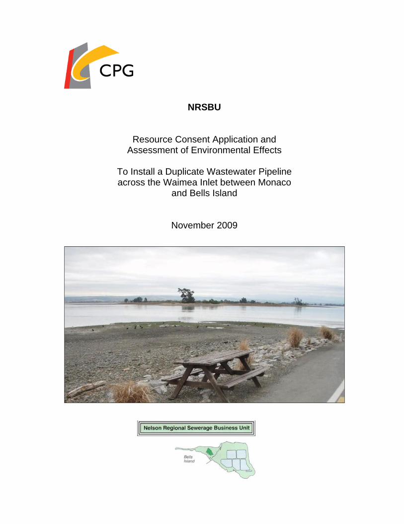
NRSBU Resource Consent Application and Assessment of Environmental Effects To Install a Duplicate Wastewater Pipeline across the Waimea Inlet between Monaco and Bells Island November 2009
-
Upload
doankhuong -
Category
Documents
-
view
219 -
download
2
Transcript of Resource Consent Application and Assessment of...
NRSBU
Resource Consent Application and Assessment of Environmental Effects
To Install a Duplicate Wastewater Pipeline across the Waimea Inlet between Monaco
and Bells Island
November 2009

NRSBU
Resource Consent Application and
Assessment of Environmental Effects
To Install a Duplicate Wastewater Pipeline in the Waimea Inlet between Monaco and Bells Island
This report has been prepared for the Nelson Regional Sewerage Business Unit (NRSBU) by CPG (formerly Duffill Watts). No liability is accepted by this company or any employee or sub-consultant of this company with respect to its use by any other parties. This disclaimer shall apply notwithstanding that the report may be made available to other persons for an application for permission or approval to fulfil a legal requirement.
Quality Assurance Statement
Task Responsibility Signature
Project Manager: Derrick Railton
Prepared by: Georgina McPherson
Reviewed by: Graham Miller
Approved for Issue by: Derrick Railton
Revision Schedule
Rev. No Date Description Prepared by Reviewed by Approved by
Prepared by: CPG New Zealand Ltd 236 Armagh Street File No.: 700000 P O Box 13-875 Job No.: 700000 Christchurch 8141 Date: November 2009 New Zealand Telephone: +64 3 374 6515
Ref: 700000-rpt251109 AEE NRSBU Duplicate Pipeline.doc
Fax: +64 3 374 6516 E-mail: [email protected]

NRSBU
Resource Consent Application and Assessment of Environmental Effects
To Install a Duplicate Wastewater Pipeline in the Waimea Inlet between Monaco and Bells Island
TABLE OF CONTENTS
1.0 INTRODUCTION 1 1.1 Purpose of this Report 1 1.2 The Nelson Regional Sewerage Business Unit 1 1.3 Background to the Scheme 1 1.4 Resource Consents Required 2
2.0 DESCRIPTION OF THE ENVIRONMENT 4 2.1 General 4 2.2 Waimea Inlet 4 2.3 Monaco Peninsula 4 2.4 Saxton Island 5 2.5 Bells Island 6 2.6 Rabbit Island 6 2.7 Estuary Bed 6 2.8 Subtidal and Intertidal Biota 7 2.9 Birds 8 2.10 Tangata Whenua Ki Whakatu 9 2.10.1 Tangata Whenua Relationship with the Waimeha (Waimea) 9 2.10.2 Archaeological Sites 10 2.11 Natural Character and Landscape Values 11 2.12 Recreation Values 11 2.13 Zoning 12
3.0 EXISTING REGIONAL WASTEWATER SCHEME 13
4.0 NEED FOR A DUPLICATE PIPELINE 15
5.0 PROJECT DESCRIPTION 16 5.1 Proposed Duplicate Pipeline 16 5.2 Nelson Golf Course Pipeline 16 5.3 Air Vents and Manholes 17 5.4 Existing Pipeline 17 5.5 The Construction Process 18 5.5.1 Possible Installation Methods 18 5.5.2 Preferred Construction Method 19 5.5.3 Construction and Material/Mechanical Equipment Storage Areas 20 5.5.4 Welding of Pipe Strings 20 5.5.5 Drilling Areas & Sediment Settling Ponds 21 5.5.6 Repair of Existing Estuary Pipeline 21 5.6 Duration of Works and Construction Hours 21 5.7 Noise 22 5.8 Traffic Movements 22 5.9 Glare 22

6.0 DEVELOPMENT OF ALTERNATIVES 24
7.0 ASSESSMENT OF PLANNING MATTERS 25 7.1 Introduction 25 7.2 The Resource Management Act 1991 (RMA) 25 7.3 Nelson Resource Management Plan 25 7.3.1 Transitional Regional Coastal Plan for the Tasman District 26 7.3.2 The Tasman Resource Management Plan 26 7.4 Activity Status 26
8.0 ASSESSMENT OF EFFECTS 34 8.1 Overview 34 8.2 Sediments in the Estuary 34 8.3 Effects on Intertidal Biota 35 8.4 Effects on Subtidal / Benthic Biota 35 8.5 Effects on Fish 36 8.6 Effects on Birds 36 8.7 Effects on Saxton Island Vegetation 37 8.8 Assessment of Possible Effects on Tangata Whenua Cultural and
Spiritual Values 38 8.9 Assessment of Possible Effects on Archaeological Sites 39 8.10 Assessment of Possible Effects of Pipeline Construction on Social
and Economic Environment 39 8.10.1 Disruption to Traffic Flows 39 8.10.2 Noise 40 8.10.3 Sand and Dust 40 8.10.4 Safety of Residents 40 8.10.5 Restriction of Recreation and Loss of Amenity Values 41 8.10.6 Landscape and Natural Character Values 41
9.0 OBJECTIVES AND POLICIES 43 9.1 Overview 43 9.2 New Zealand Coastal Policy Statement 43 9.3 Nelson Regional Policy Statement 45 9.4 Tasman Regional Policy Statement 46 9.5 Nelson Resource Management Plan 47 9.6 Tasman Resource Management Plan 49 9.7 Conclusion 49
10.0 CONSULTATION 51 10.1 Initial Consultation 51 10.2 Public Consultation Document 51 10.3 Hearing on Public Consultation Document 51 10.4 Telephone Survey 52 10.5 Tangata Whenua Ki Whakatu 52 10.6 Department of Conservation 53 10.7 Ornithological Society of New Zealand 54 10.8 Owners of Saxton Island 54
11.0 PROPOSED CONDITIONS OF CONSENT 56
12.0 CONCLUSION 59
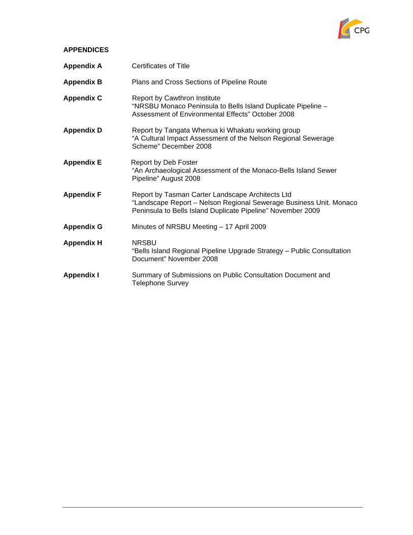
APPENDICES Appendix A Certificates of Title Appendix B Plans and Cross Sections of Pipeline Route Appendix C Report by Cawthron Institute
“NRSBU Monaco Peninsula to Bells Island Duplicate Pipeline – Assessment of Environmental Effects” October 2008
Appendix D Report by Tangata Whenua ki Whakatu working group
“A Cultural Impact Assessment of the Nelson Regional Sewerage Scheme” December 2008
Appendix E Report by Deb Foster
“An Archaeological Assessment of the Monaco-Bells Island Sewer Pipeline” August 2008
Appendix F Report by Tasman Carter Landscape Architects Ltd
“Landscape Report – Nelson Regional Sewerage Business Unit. Monaco Peninsula to Bells Island Duplicate Pipeline” November 2009
Appendix G Minutes of NRSBU Meeting – 17 April 2009 Appendix H NRSBU
“Bells Island Regional Pipeline Upgrade Strategy – Public Consultation Document” November 2008
Appendix I Summary of Submissions on Public Consultation Document and
Telephone Survey

Form 9
APPLICATION FOR RESOURCE CONSENT
UNDER SECTION 88 OF THE
RESOURCE MANAGEMENT ACT 1991 TO: Nelson City Council
The Nelson Regional Sewerage Business Unit (NRSBU), c/- CPG New Zealand Ltd, applies for the resource consents described below.
1. THE NAMES AND ADDRESSES of the owners and occupiers of any land to which the
application relates are as follows:
Owners/Occupiers: NE, JW & CC Saxton 60 Stanley Crescent
Nelson 2. THE LOCATION to which this application relates is:
The Waimea Inlet between Monaco Peninsula and Saxton Island.
Legal Description Island 6-7 District of Waimea Islands Saxton Island: NL114/234
Certificates of Title are attached in Appendix A. 3. THE TYPES of resource consent sought from the Nelson City Council are:
• A coastal permit to construct and maintain a network utility structure within the Coastal Marine Area;
• A coastal permit to undertake repairs to the existing estuary pipeline; • A coastal permit to disturb the bed of an estuary; • A coastal permit to undertake drilling in the Coastal Marine Area; and • A land use consent to undertake earthworks in the coastal environment overlay.
4. A DESCRIPTION of the activity to which the application relates is:
• The establishment and operation of a duplicate pipeline to convey wastewater from Monaco Peninsula to the Bells Island wastewater treatment plant; and
• The installation of a pipeline to convey treated wastewater from the Bells Island treatment plant to the Nelson Golf Course for the sustainable re-use of treated wastewater to meet the irrigation needs of the golf course.
• Maintenance works to repair the joints and fittings of the existing estuary pipeline.
A detailed description of the proposal is included in the attached plans and Assessment of Environmental Effects (AEE) which forms part of this application.
5. THE DURATION of consent sought is 35 years 6. THE FOLLOWING ADDITIONAL RESOURCE CONSENTS ARE REQUIRED from the
Tasman District Council:

• A coastal permit to disturb the bed of an estuary. • A coastal permit to undertake repairs to the existing estuary pipeline.
7. AN ASSESSMENT of any effects that the proposed activities may have on the environment
in accordance with the Fourth Schedule to the Resource Management Act 1991 is attached 8. THE ATTACHED assessment of environmental effects also contains any other such
information required to be included in the application by the District or Regional Plan(s) or Act or Regulations.
Signed on behalf of applicant Georgina McPherson Senior Planner CPG New Zealand Ltd Dated this 26 day of November 2009. ADDRESS FOR SERVICE of Applicant: NRSBU C/- CPG New Zealand Ltd 236 Armagh Street P O Box 13 875 CHRISTCHURCH 8141 PH: (03) 374 6515 FX: (03) 374 6516 Email: [email protected]

Form 9
APPLICATION FOR RESOURCE CONSENT
UNDER SECTION 88 OF THE
RESOURCE MANAGEMENT ACT 1991 TO: Tasman District Council
The Nelson Regional Sewerage Business Unit (NRSBU), c/- CPG New Zealand Ltd, applies for the resource consents described below.
1. THE NAMES AND ADDRESSES of the owners and occupiers of any land to which the
application relates are as follows:
Owners/Occupiers Tasman District Council Bells Island: Private Bag 4
Richmond 7050
Nelson City Council PO Box 645 Nelson 7040
2. THE LOCATION to which this application relates is:
The Waimea Inlet between Monaco Peninsula and Bells Island.
Legal Description Island No 2 (Bells) District of Waimea Islands Bells Island: NL56/193
Certificates of Title are attached in Appendix A. 3. THE TYPES of resource consent sought from the Tasman District Council are:
• A coastal permit to disturb the bed of an estuary. • A coastal permit to undertake repairs to the existing estuary pipeline.
4. A DESCRIPTION of the activity to which the application relates is:
• The establishment and operation of a duplicate pipeline to convey wastewater from Monaco Peninsula to the Bells Island wastewater treatment plant.
• The installation of a pipeline to convey treated wastewater from the Bells Island
treatment plant to the Nelson Golf Course for the sustainable re-use of treated wastewater to meet the irrigation needs of the golf course.
• Maintenance works to repair the joints and fittings of the existing estuary pipeline.
A detailed description of the proposal is included in the attached plans and Assessment of Environmental Effects (AEE) which forms part of this application.
5. THE DURATION of consent sought is 35 years

6. THE FOLLOWING ADDITIONAL RESOURCE CONSENTS ARE REQUIRED from the Nelson City Council:
• A coastal permit to construct and maintain a network utility structure within the
Coastal Marine Area; • A coastal permit to undertake repairs to the existing estuary pipeline. • A coastal permit to disturb the bed of an estuary; • A coastal permit to undertake drilling in the Coastal Marine Area; and • A land use consent to undertake earthworks in the coastal environment overlay.
7. AN ASSESSMENT of any effects that the proposed activities may have on the environment
in accordance with the Fourth Schedule to the Resource Management Act 1991 is attached 8. THE ATTACHED assessment of environmental effects also contains any other such
information required to be included in the application by the District or Regional Plan(s) or Act or Regulations.
Signed on behalf of applicant Georgina McPherson Senior Planner CPG New Zealand Ltd Dated this 26 day of November 2009. ADDRESS FOR SERVICE of Applicant: NRSBU C/- CPG New Zealand Ltd 236 Armagh Street P O Box 13 875 CHRISTCHURCH 8141 PH: (03) 374 6515 FX: (03) 374 6516 Email: [email protected]

700000-rpt251109 AEE NRSBU Duplicate Pipeline.doc Page 1
1.0 INTRODUCTION
1.1 Purpose of this Report This resource consent application and Assessment of Environmental Effects (AEE) has been prepared in support of a proposal by the Nelson Regional Sewerage Business Unit (NRSBU) to construct a duplicate wastewater pipeline across the Waimea Inlet between the Monaco Peninsula and Bells Island. The purpose of the duplicate pipeline is to safeguard against the potential failure of the existing estuary pipeline. The existing pipeline is in a poor state of repair and has been assessed as being at a high risk of failure. The environmental implications of such a failure and the resultant uncontrolled discharge of untreated sewage to the Waimea Inlet are considered to be unacceptable and there is an immediate need to address this existing situation. The proposed duplicate pipeline will follow the route of the existing pipeline from the Monaco Peninsula via Saxton Island to the Bells Island wastewater treatment plant. It will carry the entire Richmond and Nelson South catchment flow across the estuary to the treatment plant, providing a critical link in the regional sewerage network. On completion of the duplicate pipeline, it is proposed to undertake maintenance works to repair the joints and fittings of the existing estuary pipeline. Investigations are currently underway into the need for major system wide upgrades of the regional sewerage network. The proposed duplicate pipeline will provide a significant short term improvement in the efficiency and operation of the regional sewerage network and will allow the more major reticulation and pumping works that will be required in the long term to be deferred for around 8 – 10 years. Construction of the proposed duplicate pipeline also provides the opportunity to lay a secondary pipeline across the estuary to convey treated wastewater from the Bells Island treatment plant to the Nelson Golf Course for use in irrigation. This secondary pipeline would be laid in the same location and manner as the proposed duplicate pipeline. Plans illustrating the proposed works are included in Appendix B. This application has been prepared by CPG New Zealand Limited (CPG) on behalf of the NRSBU. It has been prepared in accordance with the requirements of the Resource Management Act 1991 (RMA) and sets out a consideration of the actual and potential effects of the proposed works on the environment.
1.2 The Nelson Regional Sewerage Business Unit The NRSBU (“the applicant”) is a joint committee of the Tasman District and Nelson City Councils and was instigated to look after the Councils’ interests in the Regional Sewerage Scheme. It was set up as a business unit in October 2000 and previously operated as the Nelson Regional Sewerage Authority. A Memorandum of Understanding was signed by the two Mayors and CEOs in December 2000 and governs the operation of the NRSBU.
1.3 Background to the Scheme The Nelson Regional Sewerage Scheme treats municipal waste (mainly domestic sewage) from Nelson City, Stoke, Tahunanui, Richmond, Wakefield, Brightwater and Mapua as well as industrial wastewater from Alliance Nelson, ENZA Food and Nelson Pine Industries.

700000-rpt251109 AEE NRSBU Duplicate Pipeline.doc Page 2
Wastewater from these areas is treated at the NRSBU’s Bells Island Treatment Plant and discharged into one of the main channels of the Waimea Inlet on the outgoing tide. A comprehensive review of the regional reticulation system was undertaken for the NRSBU by CPG in 2008. The review considered the needs of the region for the next 80 years and identified a number of upgrade options. The key findings of the study were:
1. Immediate action needs to be taken to duplicate the pipeline between Monaco Peninsula and Bells Island. This is necessary because of the risk of pipeline failure, which could result in serious environmental impacts and associated social, economic and cultural consequences.
2. In the longer term, major system wide upgrades will be required to provide the capacity for future flows of waste. There are a number of options for the provision of this capacity and much of the work is not required immediately.
In order to determine the preferred option for the long term pipeline strategy, the NRSBU has commissioned a range of specialist reports to assess the environmental effects of each of the options from various perspectives including cultural, ecological, landscape and archaeological. In addition, the NRSBU co-ordinated a public consultation programme in early 2009 and has undertaken consultation directly with key stakeholder groups. In May this year (2009) the NRSBU resolved to proceed with a resource consent application for the duplicate pipeline between Monaco and Bells Island. Implementation of the pipeline will allow the more major reticulation and pumping works to be deferred for around 8 – 10 years. Investigations are continuing to determine the preferred option for the long term pipeline strategy.
1.4 Resource Consents Required The proposed pipeline will cross through the administrative boundaries of both the Nelson City Council (NCC) and the Tasman District Council (TDC). Both councils are unitary authorities and therefore manage activities both on land and within the Coastal Marine Area. A detailed assessment of the proposed activities against the Nelson Resource Management Plan (NRMP), the Transitional Regional Coastal Plan for the Tasman District (TRCP) and the Tasman Resource Management Plan (TRMP) is set out below in Section 4 of this report. The consents being applied for in this application are summarised in Table 1 below: At this stage in the project it is not practical to define the exact construction methods to be used. The method for laying the pipeline will be determined through the tender process. Contractors will be encouraged to present innovative solutions to managing the construction process within the constraints of a tidal estuary environment. A variety of construction options are possible and resource consents are sought to cover several different construction techniques. Depending on the methods of pipeline construction finally chosen, some of the consents sought may not need to be exercised. Table 1: Summary of Resource Consent Requirements
Consent Authority Consent Requirement Status
Nelson City Council A coastal permit for the construction of two pipelines under the bed of the Waimea Inlet.
Discretionary activity (Rule CMr.27.3 NRMP)
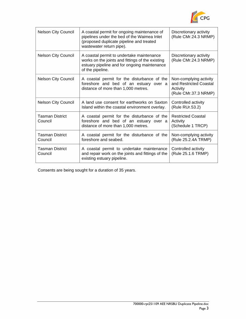
700000-rpt251109 AEE NRSBU Duplicate Pipeline.doc Page 3
Nelson City Council A coastal permit for ongoing maintenance of pipelines under the bed of the Waimea Inlet (proposed duplicate pipeline and treated wastewater return pipe).
Discretionary activity (Rule CMr.24.3 NRMP)
Nelson City Council A coastal permit to undertake maintenance works on the joints and fittings of the existing estuary pipeline and for ongoing maintenance of the pipeline.
Discretionary activity (Rule CMr.24.3 NRMP)
Nelson City Council A coastal permit for the disturbance of the foreshore and bed of an estuary over a distance of more than 1,000 metres.
Non-complying activity and Restricted Coastal Activity (Rule CMr.37.3 NRMP)
Nelson City Council A land use consent for earthworks on Saxton Island within the coastal environment overlay.
Controlled activity (Rule RUr.53.2)
Tasman District Council
A coastal permit for the disturbance of the foreshore and bed of an estuary over a distance of more than 1,000 metres.
Restricted Coastal Activity (Schedule 1 TRCP)
Tasman District Council
A coastal permit for the disturbance of the foreshore and seabed.
Non-complying activity (Rule 25.2.4A TRMP)
Tasman District Council
A coastal permit to undertake maintenance and repair work on the joints and fittings of the existing estuary pipeline.
Controlled activity (Rule 25.1.6 TRMP)
Consents are being sought for a duration of 35 years.

700000-rpt251109 AEE NRSBU Duplicate Pipeline.doc Page 4
2.0 DESCRIPTION OF THE ENVIRONMENT
2.1 General The proposed duplicate pipeline will follow the route of the existing wastewater pipeline from the Monaco Peninsula across the Waimea Inlet via Saxton Island to the Bells Island wastewater treatment plant. It will be located between 5 and 20 metres to the south of the existing pipeline. This section of the report provides a description of the locations and receiving environment that will be affected by the proposed pipeline route including the Waimea Inlet, Monaco Peninsula, Saxton Island and Bells Island.
2.2 Waimea Inlet The Waimea Inlet is located in the south of Tasman Bay between Nelson City to the east, Richmond to the south and Mapua to the west. It covers an area of approximately 3,455 ha and is the largest barrier enclosed estuary in the South Island. The Inlet provides a sheltered habitat for a diverse range of plant, invertebrate, fish and bird life and is recognised as being of significant regional, national and international value. It has been classed as a wetland of national importance by the Department of Conservation (DOC) and is recognised in the Tasman Resource Management Plan as an area with nationally important natural ecosystem values. The Inlet is a shallow bar built estuary and contains several islands. The largest of these are Rabbit Island, Rough Island, Bells Island and Bests Island. The estuary has a large tidal volume of up to 62 million cubic metres of seawater. This, in combination with the shallow nature of the estuary and the large tides in Tasman Bay results in a rapid tidal flushing. The estuary receives water from the Waimea River to the south and has two outlets to the sea. The smaller of these lies to the west of Rabbit Island at Mapua, while the much larger outlet, Blind Channel, is at the eastern end of the estuary. The margins of the estuary have been substantially modified by drainage and reclamation. Most of the land on the western side of the estuary is in pastoral, horticultural or agricultural use, although there is a small residential settlement at Mapua near the western outlet of the estuary. To the south and east of the estuary are the urban areas of Tahunanui, Monaco, Stoke and Richmond. Residential settlements adjoin the estuary at Tahunanui and Monaco, while land to the south east of the estuary between Stoke and Richmond is used primarily for commercial and industrial purposes. Operations in this area include the Alliance Group meat processing plant, the ENZA fruit processing plant and the Nelson Pine Industries wood processing plant. Within the estuary itself, Rabbit and Rough Island are predominantly planted in pines. Bests Island contains the Green Acres Golf Course and a small residential settlement at the eastern end. Bells Island is predominantly occupied by the regional wastewater treatment plant.
2.3 Monaco Peninsula The duplicate pipeline will connect into the existing sewerage network at the westernmost point of the Monaco Peninsula. It will extend from a manhole located near the intersection of
700000-rpt251109 AEE NRSBU Duplicate Pipeline.doc Page 5
Point Road and Martin Road across the foreshore and into the Waimea Inlet. This manhole is the end point of the recent Saxton Road to Monaco pipeline upgrade project which was completed in 2006. Parts of the Monaco Peninsula foreshore may also be used during the construction period for the storage of pipe sections and welding of pipe strings. The Monaco Peninsula is a sand and gravel bank on the eastern side of the Waimea Inlet. It is almost completely occupied by residential development and forms a western suburb of Nelson City. Point Road and Martin Road extend around the perimeter of the peninsula forming a boundary between the foreshore and the adjacent residential development. There are extensive areas of coastal rock protection resulting in a road/foreshore interface devoid of vegetation. The boat ramp and jetty at Martin Point provide access to the coast. However boats are launched and retrieved at various places around the peninsula and vehicles drive across the intertidal area on a fairly regular basis. Vehicle access is particularly common on the southeastern side of the peninsula where a section of Point Road crosses below Mean High Water Springs (MHWS) and is accessible at low tide. A number of residential properties as well as some small businesses, a cafe, gift shop and accommodation, are located at the western tip of the peninsula. A small council reserve, Foster Reserve, is also located at the western tip of the peninsula.
2.4 Saxton Island Saxton Island is one of several islands located in the Waimea Inlet. The island is a serpentine bar comprising well sorted gravel with sandy beaches that extend only a metre or so above MHWS. There is a broad intertidal region along the northern side of the island and the proposed duplicate pipeline and the return pipeline will cross through this area on the landward side of the existing wastewater pipe. Two new air valves will be constructed in this intertidal region in close proximity to the air valves associated with the existing pipeline. The island is in private ownership and is accessible only by boat. Several baches are present on the island and are used intermittently throughout the year. There are no permanent residents on the island. Vegetation on the island comprises a mix of natural and modified plant communities including sheltered salt marshes, fields of Stipa stipoides Needle Tussock and Ngaio / Coprosma groves. There are several native intertidal succulents on the island including Sarcocornia quinquefolia – Glasswort, Selliera radicans – Remuremu, Sueda novae – zealandiae – Sea Blite. Saxton Island is also home to two plots of Lepidium banksii – coastal peppercress, which has been identified by DOC as a nationally critically threatened plant species. The plant has been translocated to the island and both plots are actively managed by DOC staff. The plot on the northeastern shoreline of the island is located approximately 7 – 8 metres inland of the existing pipeline in a copse of Coprosma repens, Muehlenbecia complexa and marram grass. The proposed new pipelines will be laid so as to avoid disturbing the peppercress plants. In addition an invasive succulent species Wilsonia backhausi has been identified along the proposed pipeline route on the northern side of the island. The plant extends through areas of the foreshore and intertidal zone and is present in close proximity to the existing air valves.

700000-rpt251109 AEE NRSBU Duplicate Pipeline.doc Page 6
The plant has been classified by DOC as an invasive weed with potential to threaten the intertidal habitats of the inlet and the wider coastal area of Tasman Bay. It is a coloniser of cobble substrate and competes with native estuarine species. The plant has not been found in any other parts of the Waimea Inlet. DOC is currently seeking resource consents from the Nelson City Council to undertake a spray eradication programme in late 2009. There is historical evidence that the island was used or occupied by Maori including a scheduled archaeological site located at the easternmost point of the island. Further information on this site is set out in section 2.9 below.
2.5 Bells Island Bells Island is one of the larger islands in the estuary and is jointly owned by the Nelson City and Tasman District Councils. The island is largely occupied by the regional wastewater treatment plant which comprises a series of bunded oxidation ponds. Vehicle access to the island is available at low tide via a concrete causeway between Bests and Bells Island. There is an area of farmland at the northwestern end of the island, which is currently leased for dairy farming. The far western end of the island is managed in pine plantation. Most of the island is surrounded by natural sand beaches interspersed with some areas of mud and deposits of softer sand or stone cobbles. Riparian vegetation on the island is made up predominantly of a mixture of gorse and pines interspersed with some limited native vegetation. Some native planting has been undertaken at the southeastern end of the island close to the arrival point of the existing pipeline route. To the north of the existing pipeline, approximately 300 metres away, is a significant bird nesting and roosting area on the Bells Island shellbanks. A scheduled archaeological site is located approximately 50 metres to the south of the pipeline extending inland from the foreshore area. These sites are described in more detail in sections 2.9 and 2.10.1 below. The proposed duplicate pipeline will come ashore on Bells Island approximately 10 – 20 metres to the south of the existing pipeline. The return pipeline taking treated wastewater to irrigate the Nelson Golf Club will leave Bells Island at the same point, approximately 300mm to the north of the duplicate pipeline.
2.6 Rabbit Island The eastern tip of Rabbit Island has been identified as a potential location for the storage of materials and welding of pipe strings. Rabbit Island is predominantly occupied by plantation forestry and any activities associated with construction of the duplicate pipeline would take place on the sandy foreshore area.
2.7 Estuary Bed The Cawthron Institute undertook field surveys of the Waimea Inlet, in August and September 2008, in order to characterise the site environment. The survey included an assessment of substrate characteristics as well as subtidal and intertidal habitats in the vicinity of the proposed pipeline route. Approximately 4.8 hectares of the estuary bed was included in the survey area, representing the potential construction footprint of 10 metres either side of the 2.4 km pipeline route. Substrates along the course of the pipeline vary as the route extends over the beaches and intertidal zones of Monaco Peninsula, Saxton and Bells Islands and into the deeper subtidal channels between Monaco and Saxton Island and between Saxton and Bells Island.
700000-rpt251109 AEE NRSBU Duplicate Pipeline.doc Page 7
In total, approximately 1km of the pipeline route will be over beach areas on Monaco Peninsula, Saxton and Bells Islands. Beach substrates in these locations typically comprise firm packed cobble/shingle fields with varying degrees of mud and sand. Another 1km of the pipeline route will be over intertidal areas on Monaco Peninsula, Saxton and Bells Islands. Intertidal habitats in these locations comprise a mix of cobble, shingle and mud with varying degrees of sand, shell and shingle. The final 0.4km of the pipeline route will be through the deeper subtidal channels of the estuary. Benthic substrates in the Monaco-Saxton channel vary from cobble/sand to areas of cobble/shingle/mud while substrates in the Saxton-Bells channel include a mix of gravel/coarse sand and mud/fine sand/gravel substrate. Please refer to the Cawthron Institute report titled “NRSBU Monaco Peninsula to Bells Island Duplicate Pipeline – Assessment of Environmental Effects”, which is included in Appendix C for a detailed description of bed substrates at each of the survey locations.
2.8 Subtidal and Intertidal Biota The Cawthron report (refer Appendix C) also provides a detailed assessment of estuary biota in the vicinity of the proposed pipeline route. The survey results indicate that the mix of species and communities in this part of the estuary is typical of the Waimea Inlet as a whole and is indicative of a healthy and productive intertidal/subtidal environment. Three features in the vicinity of the pipeline route were specifically identified as being of some ecological significance in the Waimea Inlet:
• Eelgrass or Zostera beds located in the lower intertidal habitats between Bells Island and Saxton Island.
• Several patches of sabellaird tubeworm mounds were identified in the intertidal/subtidal zones of Bells Island, Saxton Island and Monaco Peninsula.
• Two sponge gardens – one in the Monaco-Saxton Island channel and a second in the Saxton-Bells Island channel. These gardens are considered ecologically important in terms of their relatively limited distribution in the Waimea Inlet and the diversity of life they support.
A review of previous estuary surveys undertaken by the Cawthron Institute between 1999 and 2006 suggests that the eelgrass and sabellarid tubeworm populations are relatively robust and have remained stable despite the dynamic nature of their location (e.g. strong current flows, large tidal ranges) and the nearby wastewater outflow. The sponge garden off Bells Island was newly discovered during the 2008 surveys and is thought to be a result of improvements in estuary water quality and flow dynamics in recent years. The subtidal survey of the Monaco-Saxton channel found sponges in the immediate vicinity of the existing pipeline, indicating that sponges have re-colonised the area following installation disturbance. Bed substrates in the Monaco-Saxton and Saxton-Bells channels are soft and are subject to periodic disturbance during storms causing resuspension of sediments and elevated levels of turbidity. The Cawthron report indicates that as a result, communities in these habitats have a degree of inherent tolerance to increased turbidity. The report notes that much of the upper and middle zone of the intertidal habitats on Monaco Peninsula and Bells Island has already been altered by previous shoreline

700000-rpt251109 AEE NRSBU Duplicate Pipeline.doc Page 8
modifications. These regions are considered to be of limited ecological diversity and productivity. Forty-one species of fish have been recorded in the Waimea Inlet, most of which enter the estuary with the incoming tide. A number of fish use the estuary to breed and spend their juvenile life in the sheltered waters until they are ready to go out to sea.
2.9 Birds The Nelson / Tasman region is nationally significant for wading birds which breed on estuaries and inlets along the coast or visit on migration from the northern hemisphere. Farewell Spit is one of five sites in the country designated under the Convention on Wetlands of International Importance especially as Waterbird Habitat (RAMSAR). Waimea Inlet, Moutere Inlet, Motueka Sandspit, and Westhaven Inlet are all wetlands of national importance and are used by a wide variety of bird species. The Tasman District Council published an overview of the biodiversity of the Tasman District in 2008 (Tasman Biodiversity Overview 2008). This document identifies a number of bird species of particular significance that are found in the Waimea Inlet including:
• Variable Oystercatcher Haematopus unicolour (resident)
The estuary is home to significant numbers of Variable Oystercatchers. Studies by the Ornithological Society of New Zealand (OSNZ) indicate that Waimea Inlet is a settling area for birds that have been hatched elsewhere in the country. The national population of Variable Oystercatchers is only around 4000 birds
• Wrybill Anarhynchus frontalis (winter visitor)
The Bells Island shell banks have been identified by OSNZ as an important staging point for Wrybill during the spring migration, although the birds nest outside the district on Canterbury and Otago rivers.
• Bar-tailed Godwit Limosa lapponica (non-breeding visitor)
Significant numbers of Bar-tailed Godwit migrate to Tasman Bay from Alaska in September / October to over-winter and feed prior to their return journey. Around 4500 birds have been observed in Tasman Bay concentrated at Motueka Sandspit and the Bells Island shell banks.
• Black Fronted Terns Sterna albostriata (resident)
The Black-fronted Tern has been identified by DOC as a threatened species ‘in serious decline’. The Waimea Inlet is home to a significant population of terns with over 300 birds being observed on Bells Island in April 2006 by the OSNZ.
• Banded Rail Rallus philippensis assimilis (resident)
An estimated 85 pairs were recorded breeding in the district in 1980-82, representing most of the South Island’s population. Re-surveys of Golden Bay in 1994 and Waimea Inlet in 1990 and 1997/98 found that numbers had apparently changed little at these two sites.
• Caspian Tern Sterna caspia (breeding visitor)

700000-rpt251109 AEE NRSBU Duplicate Pipeline.doc Page 9
Caspian Terns have been observed to breed at Bells Island since the mid-1980s and the shell banks are considered to provide a nationally important breeding colony.
The main areas of significance to bird species in the estuary are the Bells Island shell banks, the saltmarsh areas on the estuary margins and the intertidal areas which provide substantial feeding grounds for a variety of bird species. The Bells Island shell banks are located off the eastern end of Bells Island and are approximately 300 metres to the north of the area of works.
2.10 Tangata Whenua Ki Whakatu The Waimea Inlet, its islands, and the plains that surround the estuary have a long and rich Maori history that reaches back to the earliest tribes known to have lived in the South Island. The name Waimea was originally “Waimeha”, which means brackish or insipid water. Manawhenua (customary authority) over the area is held by six iwi who are affiliated with Whakatu Marae and have a close relationship with Te Tau Ihu (the top of the South Island):
• Ngati Koata; • Ngati Kuia; • Ngati Rarua; • Ngati Tama; • Ngati Toa; and • Te Atiawa.
Manawhenua relates to political and occupational authority over a particular area and carries a responsibility to manage resources sustainably for future generations. This responsibility is realised through kaitiakitanga (guardianship), which involves the application of resource management practices, rules and techniques to ensure the long term well being of the natural environment. A central duty is to protect and strengthen the mauri (life force) and wairua (spirit) of a resource, place or taonga. In order to understand the key values relevant to the duplicate pipeline proposal, the NRSBU has engaged in extensive consultation with the tangata whenua ki Whakatu working group, which represents the six iwi affiliated with the Whakatu Marae. A Cultural Impact Assessment (CIA) has been prepared by the working group to assist the NRSBU in considering the cultural impacts of the proposals. The CIA describes the relationship of tangata whenua with the Waimeha estuary and the ways this has been affected over time by changing land uses and modification of the estuary margins. The report also sets out an assessment of the proposed duplicate pipeline on the cultural and spiritual values of tangata whenua. A copy of the CIA is included in Appendix D.
2.10.1 Tangata Whenua Relationship with the Waimeha (Waimea) The relationship of tangata whenua with the Waimeha estuary encompasses the spiritual and physical realms. Tangata whenua view the estuary as part of a wider system, which encompasses the entire catchment area. This includes the waterways flowing from the Gordon Range, eastern slopes of the Richmond and Bryant Ranges and Dun Mountain through the flood plains to the coastal waters and out to sea. The CIA reveals that the estuary and adjoining Waimeha Plains have been used extensively by tangata whenua as far back as the 13th and 14th centuries during the period known as the Great Migration from Hawaiki to New Zealand.

700000-rpt251109 AEE NRSBU Duplicate Pipeline.doc Page 10
The estuary provided sheltered canoe routes, landings and campsites as well as valuable food, stone and timber resources. Food gathered from the Waimeha estuary included a variety of fish, shellfish and seabirds, while the swamp forests and wetlands bordering the estuary provided food such as Pukeko, Kereru, Tui, and Kaka. Eels and ducks were abundant and Inanga (whitebait) could be caught in the streams. Land on either side of the Waimeha River extending from the estuary up as far as Brightwater was cultivated and represents some of the largest known Maori gardening soils in New Zealand. Important resources such as flax, medicinal plants, timber and other building materials were sourced from the swamp forests and wetlands bordering the estuary, while argillite, used for a range of fine tools and weapons was found in the hillsides above. Argillite was important for trade and along with kumara and dried snapper, was traded with the West Coast iwi for raw and worked pounamu. The estuary provided a gateway to the trading route between Whakatu (Nelson) and Te Tai Poutini (West Coast). Waka (canoe) and Koiwi (human skeletal remains) have also been found on the estuary’s islands and edges.
2.10.2 Archaeological Sites The New Zealand Archaeological Association (NZAA) Site Recording Scheme records thirty five individual archaeological sites within approximately 200m of the Waimea Inlet. To make sure that any such site would not be disturbed by the pipeline construction and to assess the route of the pipeline for other sites of heritage/archaeological value an archaeological assessment of the pipeline route was commissioned. This report titled “An Archaeological Assessment of the Monaco-Bells Island Sewer Pipeline” is included in Appendix E. The sites listed by NZAA are mainly middens containing shells from different food items like pipi, cockles and mudsnails. Of these, two sites are located within the vicinity of the proposed pipeline route. Site number N27/136 is the site of a midden/oven. It is located on the eastern most tip of Saxton Island more than 100 metres away from the pipeline route and is unlikely to be affected by the construction of the duplicate pipeline. The site is recorded as midden / ovenstones / stoneworking and is reported to include some moa hunter material. It is referenced in the NRMP as archaeological site MS23. A survey of N27/136 and the entire perimeter of the island by archaeologist Deb Foster in 2008 did not find any additional sites on the island (full report contained in Appendix E). However, the fact that site number N27/136 extends well into the intertidal zone was considered to highlight the possibility that additional archaeological material could be discovered below the high tide mark during pipe laying. In addition, a burial site that was discovered on the southern side of the island in 1990, but is not recorded on the NZAA site recording scheme, was considered to emphasise the potential for accidental discovery of burials in other locations on the island. Site number N27/141 is a recorded midden/oven site. It is located adjacent to a stream at the southeastern end of Bells Island and is approximately 50 metres to the south of where the existing pipeline comes ashore. The site is recorded as a midden with oven stones eroding out of the beach front section. The site is referenced in the TRMP as archaeological site TDC 16014.

700000-rpt251109 AEE NRSBU Duplicate Pipeline.doc Page 11
Test pitting was undertaken in the general environs of the site by archaeologist Deb Foster in 2008 to determine the full extent of the site. The results of the test pitting indicate that the site extends approximately 40 metres to the south of the stream mouth and approximately 40 metres out onto the beach and intertidal area. The northern extent of the site was more difficult to determine. However the test pitting indicated that the proposed duplicate pipeline could be laid up to 20 metres south of the existing line with relatively little impact on the archaeological site. A new site, N27/181, was recorded on the Monaco Peninsula during the archaeological investigations undertaken for the duplicate pipeline project. The site is not in an area that will be directly affected by the proposed works. However it is significant in terms of highlighting the potential for accidental discovery of previously unrecorded sub-surface evidence during construction of the pipeline.
2.11 Natural Character and Landscape Values A landscape report was commissioned to identify the landscape and visual values of the Waimea Inlet. A copy of the landscape report, prepared by Tasman Carter Ltd is included in Appendix F. The report notes that the eastern portion of the Inlet, to the east of Rabbit Island, has been extensively modified by development within the Richmond, Tahunanui and Monaco Peninsula urban areas as well as the wastewater treatment plant on Bells Island. The western part of the Inlet is less developed and was considered to have higher landscape values and aesthetic qualities than the eastern side. The Monaco Peninsula is dominated by residential development and is completely devoid of riparian vegetation, with the road extending right down to the foreshore area. As a result, the natural character and landscape values of the peninsula were considered to be relatively low. Saxton Island was identified as harbouring significant natural character values as well as some modified landscapes. A range of natural habitats are present on the northern side of the island including some relatively undisturbed patches of Stipa stipoides Needle Tussock and a small plot of the critically endangered Lepidium banksii Coastal Peppercress. Bells Island is predominantly occupied by the wastewater treatment plant and the natural character and landscape values of the island have been highly modified. Some native planting has been undertaken at the southeastern end of the island. However, much of this has been overtaken by gorse. Overall, the landscape report considered the Waimea Inlet to have intrinsic coastal and natural character values that are widely recognised by the community. However the report notes that the Inlet has not been formally identified as an Outstanding Natural Landscape or Outstanding Natural Feature in the Tasman District or Nelson City Resource Management Plans.
2.12 Recreation Values The Waimea Inlet is used for a range of recreational activities including boating, fishing, swimming, water-skiing, duck shooting, walking and bird-watching. The most popular areas of the Inlet are Tahunanui 'back beach', Monaco, Rabbit Island (the Rabbit Island gates are closed at night) and Mapua. Boat ramps are provided at Nelson, Monaco, Mapua and the inside of Rabbit Island (high tide only).

700000-rpt251109 AEE NRSBU Duplicate Pipeline.doc Page 12
The main bird watching location is the north-eastern corner of Bells Island at high tide during the summer season, when there are many northern hemisphere migratory birds present.
2.13 Zoning The district boundary runs through the Waimea Inlet between Saxton Island and Bells Island. The western and southern portions of the Inlet, comprising approximately two thirds of the estuary, are administered by the Tasman District Council. The eastern part of the estuary including Saxton Island and the Monaco Peninsula are administered by the Nelson City Council. Table 2 below summarises the relevant zoning and planning map references that apply to each part of the proposed pipeline route. Table 2: Relevant zoning and planning maps
Nelson Resource Management Plan
Zoning Saxton Island • Rural Zone • Riparian overlay • Coastal Environment overlay • Archaeological Site MS23
Waimea Inlet • Marine Area of Significant Conservation Value (ASCV) • Management for Fisheries, Fish Spawning, Aquatic Ecosystems
and Aesthetic Purposes (FEA)
Monaco Peninsula • Coastal Environment overlay • Inundation overlay • Riparian overlay • FEA & Contact Recreation overlay
Planning Maps 26; 54; A1.1; A1.2; A1.3
Tasman Resource Management Plan
Zoning Bells Island • Industrial • Coastal Environment Area • Archaeological Site TDC 16014
Rabbit Island • Open Space Zone • Rural 2 Zone • Coastal Environment Area
Waimea Inlet • Schedule 25.1F Area with nationally important natural ecosystem
value • Schedule 18.1C Significant Natural Area
Planning Maps 55 and 57
700000-rpt251109 AEE NRSBU Duplicate Pipeline.doc Page 13
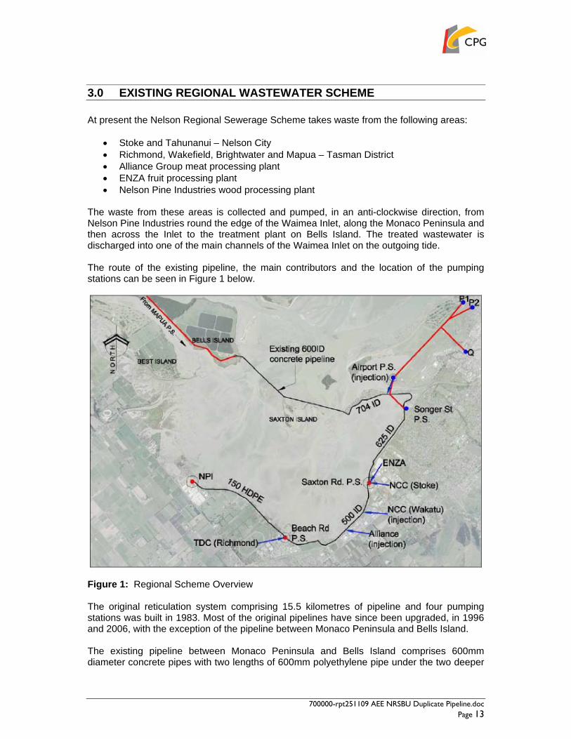
3.0 EXISTING REGIONAL WASTEWATER SCHEME At present the Nelson Regional Sewerage Scheme takes waste from the following areas:
• Stoke and Tahunanui – Nelson City • Richmond, Wakefield, Brightwater and Mapua – Tasman District • Alliance Group meat processing plant • ENZA fruit processing plant • Nelson Pine Industries wood processing plant
The waste from these areas is collected and pumped, in an anti-clockwise direction, from Nelson Pine Industries round the edge of the Waimea Inlet, along the Monaco Peninsula and then across the Inlet to the treatment plant on Bells Island. The treated wastewater is discharged into one of the main channels of the Waimea Inlet on the outgoing tide. The route of the existing pipeline, the main contributors and the location of the pumping stations can be seen in Figure 1 below.
Figure 1: Regional Scheme Overview The original reticulation system comprising 15.5 kilometres of pipeline and four pumping stations was built in 1983. Most of the original pipelines have since been upgraded, in 1996 and 2006, with the exception of the pipeline between Monaco Peninsula and Bells Island. The existing pipeline between Monaco Peninsula and Bells Island comprises 600mm diameter concrete pipes with two lengths of 600mm polyethylene pipe under the two deeper

700000-rpt251109 AEE NRSBU Duplicate Pipeline.doc Page 14
parts of the estuary. An assessment of the condition of the existing pipeline undertaken by CPG in 2007 concluded that some of the fittings joining sections of the pipe, and in particular some fittings which could not be located, are likely to be in a very fragile condition and there is a real risk of failure in the near future.

700000-rpt251109 AEE NRSBU Duplicate Pipeline.doc Page 15
4.0 NEED FOR A DUPLICATE PIPELINE In 2007 CPG was commissioned to undertake a comprehensive review of the regional reticulation system serving the Bells Island Wastewater Treatment Plant. This review considered the needs of the region for the next 80 years and identified a number of upgrade options to meet these requirements. The key findings of the review were presented in the NRSBU Regional Pipeline Strategic Issues and Options Report issued in June 2008. The study reported on the condition of the Monaco to Bells Island section of pipeline, which is the only section of the original reticulation scheme that has not been replaced. In terms of system operation, this section of pipeline is critical as it provides the only link across the estuary to the treatment plant and carries the entire Richmond and Nelson South catchment flow. Whilst the pipeline itself appears to be in reasonable condition, the condition of some of the joints and fittings on the pipeline was found to be questionable. These joints and fittings were considered to pose an unacceptable risk of potential failure and the pipeline was considered overall to be in an unacceptable condition. In order to repair or replace the existing pipeline, a duplicate line must be laid across the estuary. This is because:
• There is currently no alternative way to deliver wastewater to the Bells Island treatment plant;
• It is not possible to repair the pipeline while it is in use; • There is limited ability to store wastewater within the system; therefore closing this
section while repairs are undertaken is not feasible. For these reasons, as well as the serious environmental consequences of pipeline failure, the report concluded that immediate steps should be taken to duplicate the line as soon as possible. In May 2009 the NRSBU resolved to proceed with a resource consent application for the duplicate pipeline between Monaco and Bells Island. Implementation of the pipeline will allow the more major reticulation and pumping works that will be required in the longer term to upgrade the regional system to be deferred for around 8 – 10 years. Investigations are continuing to determine the preferred option for the long term pipeline strategy.

700000-rpt251109 AEE NRSBU Duplicate Pipeline.doc Page 16
5.0 PROJECT DESCRIPTION
5.1 Proposed Duplicate Pipeline The NRSBU (“the applicant”) proposes to construct a duplicate wastewater pipeline across the Waimea Inlet from Monaco Peninsula to the Bells Island wastewater treatment plant. The proposal will meet the immediate need to duplicate the existing estuary pipeline to safeguard against the potential failure of the existing pipeline. It will also provide a significant improvement in the efficiency and operation of the sewerage network and will allow the more major reticulation and pumping works that will be required to upgrade the system in the long term to be deferred for around 8 – 10 years. The proposed duplicate pipeline will follow the route of the existing pipeline across the estuary. It will extend from the end of the Monaco Peninsula across the channel to the eastern end of Saxton Island. From here it will continue along the northern side of Saxton Island before crossing a second channel in the estuary and connecting into the wastewater treatment plant at Bells Island. The duplicate pipeline will be approximately 2.4km in length and will be installed on the southern side of the existing pipeline. The separation distance between the two pipelines will vary between 5 and 20 metres to take account of various features along the route. The proposed pipeline will be located no more than 20 metres to the south of the existing line, while a minimum separation distance of 5 metres will be maintained so as to avoid the risk of damage to the existing pipeline during construction works. The majority of the pipeline route will be through the coastal marine area of the Waimea Inlet. Works will be required above the level of MHWS at the western end of the Monaco Peninsula where the duplicate line will connect into the existing sewerage network at a manhole near the junction of Point Road and Martin Road. Two very short sections of pipeline may extend slightly above the level of MHWS at Saxton Island in the vicinity of the existing air valves. Works will also be required above the level of MHWS at the southeastern end of Bells Island where the proposed pipeline will come ashore to connect into the wastewater treatment plant. The pipeline will either be 800 or 900mm OD (outside diameter) high density polyethylene pipe (HDPE), the final diameter selection being subject to confirmation during the final design process. The pipeline will be buried with at least 1 metre cover below the bed of the estuary.
5.2 Nelson Golf Course Pipeline A secondary element of the proposal involves the installation of a second, smaller pipeline to convey treated wastewater from the Bells Island treatment plant to the Nelson Golf Course for the sustainable re-use of treated wastewater to meet the irrigation needs of the golf course. The pipeline size is also subject to confirmation, but is likely to be 180 to 250mm OD HDPE. The secondary pipeline would be laid together with the proposed duplicate pipeline and would follow the exact same route through the estuary between Bells Island and the western end of the Monaco Peninsula. It would be located approximately 300mm to the north of the

700000-rpt251109 AEE NRSBU Duplicate Pipeline.doc Page 17
duplicate pipeline. The treated effluent return pipeline would be 2.4km in length and buried at least 1 metre below the bed of the estuary. This estuary pipeline to convey treated wastewater from the Bells Island wastewater treatment plant to the Monaco Peninsula forms an essential component of the golf course irrigation project. The construction of this irrigation pipeline together with the NRSBU’s larger duplicate pipeline is seen as an ideal opportunity to bring forward this essential component of the irrigation project, which may not otherwise have been financially viable as an individual pipeline development. Resource consents are being sought to provide for the construction and installation of this secondary pipeline. However, this application does not seek any additional consents that may be required to convey treated wastewater from the end of the Monaco Peninsula to the golf course itself or to use the treated wastewater for irrigation purposes.
5.3 Air Vents and Manholes The installation of air vent structures will be required at two locations on Saxton Island to vent any locked air to make sure that the wastewater pumps effectively along the pipeline and does not become air locked at any point along the route. These will be very similar to the existing two air vent structures and will be immediately adjacent to the existing ones. Similarly, air vents will be required at these locations for the secondary pipeline to convey treated wastewater from Bells Island to the end of the Monaco Peninsula, but the installation of these will be combined in the same structure as for the main pipeline vents. These structures will be located within the intertidal area close to MHWS and will extend to approximately 1 metre in height above ground level. Upgrade or replacement works will be required to the manhole at the end of Monaco Peninsula to provide for the connection of the proposed duplicate pipeline into the existing network. The structure will be finished to a similar standard as the existing manhole, which is visible at ground level adjacent to Point Road. The temporary closure of a portion of Point Road in the vicinity of the manhole may be required during connection of the proposed pipeline into the existing sewerage network and related works.
5.4 Existing Pipeline The existing pipeline, together with the new pipeline, will form part of the Long Term Strategy for the Regional Sewerage Scheme, notwithstanding that further work is required to confirm particular details of that strategy. Work on the long-term strategy is continuing and the selection of a preferred option may still be some way off. Once the new pipeline is installed, the existing pipeline can then be safely inspected and repairs undertaken to the joints and fittings as necessary. Four key joints have been identified as needing repair or replacement. These are located on either side of the two main estuary channels. Ultimately, depending on the longer term condition of the concrete pipe, it is envisaged that a smaller approximately 500mm diameter polyethylene pipeline will be inserted into the existing line to maintain the continued integrity of the existing pipeline.

700000-rpt251109 AEE NRSBU Duplicate Pipeline.doc Page 18
5.5 The Construction Process A range of construction methods are available for installation of the pipeline across the estuary. The final construction approach will be determined through selection of an experienced contractor through the tender process once the necessary resource consents have been obtained. As elements of the construction process will vary depending on the adopted pipe laying method, the contractor will be required to produce a Construction Management Plan prior to the commencement of works setting out details of the construction approach including:
• The type of construction method to be adopted. • The key locations required for activities associated with construction works. • A construction programme including timetable, sequence of events, hours of
operation and duration. • Detailed information about traffic, noise, dust and navigational safety. • Detailed information on how potential environmental effects will be mitigated.
The Construction Management Plan would be subject to Council approval. In broad terms, three possible methods for installing the pipeline across the estuary have been identified and are described below. In addition, an overview of associated activities such as the location of construction and storage areas, welding of pipe strings and the need for drilling areas and sediment settling ponds has been provided below.
5.5.1 Possible Installation Methods An overview of three potential methods of construction is set out below:
• Open trench / dig and lay – Open trenching would involve the use of diggers to excavate a trench across the estuary into which the pipe strings would be positioned.
In shallow parts of the estuary, excavators would drive out onto the estuary bed during low tide conditions to excavate the trench, though the diggers may be barge mounted in some cases. Timber platforms or pads are likely to be required to prevent the excavators from sinking into mud particularly where soft sections of material are encountered. . Where the pipeline crosses the deeper channels and for other sections if necessary, excavators will need to work off barges. Sheet piling may be used on some sections of the trench to prevent collapse and minimise the width of the excavation and the effects of sedimentation. There may also be a need to use sheet piling around the air vents and manhole structures to facilitate connection of the pipeline into the existing network.
Excavated material would normally be laid adjacent to the open trench on the bed of the estuary during construction and used to back fill the top part of the trench once the pipe is laid. In some sensitive areas, it may be possible to use geotextile mega-containers (geobags) to store the temporarily removed sediments adjacent to excavations in order to prevent them being washed away and spread across the broader region.
The trench will generally be 2 metres deep and 1.5 – 2.5 metres wide. With an associated 10 metre zone either side of the pipeline, the total width of disturbance across the estuary will be approximately 20 metres.

700000-rpt251109 AEE NRSBU Duplicate Pipeline.doc Page 19
Open trenching may involve installation by several short sections (i.e. as much as can be dug in a day) or multiple excavators working at once to install longer sections at a time. There would be limited need to import fill material or dispose of excavated material from the trench off-site under this construction approach.
• Mole ploughing – This method involves laying pipe strings on the bed of the estuary from where they would gradually be sunk into the bed by running a ploughing device up and down the length of the pipe section.
Mole ploughing would require the establishment of a winching base at each end of a pipe section. These would likely be at a point on Monaco Peninsula, a point on Saxton Island and a point on Bells Island. The mole ploughing method would also require sections of open trenching to complete the installation at the ends of the pipe runs i.e. an open trench would need to be constructed at Monaco Peninsula, Saxton Island and Bells Island in the intertidal zone. This method is less likely to be used because of limitations in experience and equipment held by the NZ contracting industry.
• Directional drilling / trenchless methods – Trenchless methods would involve
establishing a series of drill pits (open trenches) across the estuary at Monaco Peninsula, Saxton Island and/or Bells Island. Depending on the length of pipeline that can be installed at once, additional drill pits may be required. It is expected that drilling lengths of 300 – 400 metres may be feasible, thus requiring 6 or 7 such drill pits. At each of these locations a drilling rig, slurry pumps and tanks would be set up. A remote controlled drill would be used to drill between these points under the bed of the estuary. The tunnel would be progressively opened out by passing reamers back and forth along a winch. Each pass of the reamer would increase the diameter of the tunnel until the required diameter is reached. Excavated material from the tunnels would be dewatered and transported by barge and/or truck to a pre-approved disposal location. Pipe strings would be inserted into the drilled holes.
Prior to any construction work, a geotechnical investigation would determine the presence of any gravel or rock layers at depths that may affect sheet piling, mole ploughing or directional drilling.
5.5.2 Preferred Construction Method Of the three potential methods of constructing the pipeline across the Waimea Inlet, the open trenching method is the most preferred by the NRSBU as it represents the most cost effective approach. Both the mole ploughing and directional drilling options would offer reduced disturbance of the estuary bed. However these methods are financially expensive in comparison with the dig and lay method. The method for laying the pipeline will be determined through the tender process. Contractors will be encouraged to present innovative solutions to managing the construction process within the constraints of a tidal estuary environment. Resource consents are being sought to cover all three of the potential construction methods described above. However,

700000-rpt251109 AEE NRSBU Duplicate Pipeline.doc Page 20
depending on the method of pipeline construction finally chosen, some of the consents sought may not need to be exercised.
5.5.3 Construction and Material/Mechanical Equipment Storage Areas Several construction areas will be required for the construction of the pipeline with the exact requirements varying slightly depending on which pipe laying method is used. Construction and material / mechanical equipment storage areas will be needed for all construction methods. Construction activities will occur in the following areas:
• Monaco Peninsula – The foreshore region off Point Road at the end of the Monaco Peninsula will be used as the main construction area for the storage of materials and equipment including excavators, barges, welding equipment, generators, pipe fittings, pipe weights and site caravan/amenities. This area is identified on Sheet C01 contained in Appendix B. Materials and equipment will be delivered to the Monaco Peninsula area by truck or barge and transported by barge to other construction sites in the estuary from the Martin Point boat ramp. This boat ramp will provide a key access point to the estuary for labour, materials and equipment.
• Saxton Island – Wherever practicable, equipment and machinery required for
construction works in the vicinity of Saxton Island will be stored on barges rather than on the island. Vehicle use and access on the island will be limited to the existing road along the border between the high intertidal and foreshore region. Should there be a need for the temporary storage of vehicles or equipment on the island, this will be restricted to the road or higher intertidal habitats away from the tussock border.
• Access will be restricted from the areas of tussock adjacent to the proposed air vents on Saxton Island as shown on Sheet C01 contained in Appendix B. No storage of pipes or welding of pipe strings is proposed on Saxton Island.
• Bells Island – The foreshore of Bells Island at the southeastern end of the island has
been identified as a potential storage and work area. The area of land immediately behind the beach would be used for the storage of pipes, construction of pipe strings and their dispatch for pressure testing and installation along the pipeline route. Bells Island would also be used as an access point to the Inlet for labour, materials and equipment required during the installation process.
• Rabbit Island – Rabbit Island is a potential pipe storage site and / or work area. The
area of storage / work would be on the beach and within the intertidal zone at the eastern end of the island as identified on Sheet C01 contained in Appendix B. Construction material would be delivered to Rabbit Island by truck or barge.
5.5.4 Welding of Pipe Strings For all construction methods there will be a need to weld pipe strings and store them temporarily prior to pressure testing and positioning into their final alignment. Welding of pipe strings will take place at the end of the Monaco Peninsula with welded pipe strings being stored on the foreshore alongside Point Road. It is likely that pipe strings will

700000-rpt251109 AEE NRSBU Duplicate Pipeline.doc Page 21
be welded into three or four sections of around 600m – 800m in length, which would then be flanged together just prior to installation.
The contractor may prefer to weld and store some lengths at Monaco Peninsula and others on the foreshore of Bells Island or Rabbit Island if there is insufficient space at Monaco.
Pipe strings will be towed to a point nearby in deeper water, where they will be anchored temporarily and pressure tested prior to positioning into their final alignment.
5.5.5 Drilling Areas & Sediment Settling Ponds Drilling pits and sediment settling ponds will be required if a directional drilling technique is adopted. It is expected that drilling lengths of 300 – 400 metres may be feasible meaning that up to 6 or 8 drilling pits would be required. Drilling areas will be about 10m by 5m wide, including a larger area around each drilling pit in the order of 2000 – 3000 m2. If a trenchless or directional drilling technique is used, it will be necessary to provide settling structures for the separation of estuary sediments and drilling muds. These would be adjacent to each drill pit and would be fenced off to members of the public. Settling structures could comprise transportable settling tanks or if the drilling pits are located close to the shore of the estuary, the contractor may prefer to install ponds to settle out the mud. Excavated mud would be removed and disposed of off-site in a pre-approved location.
5.5.6 Repair of Existing Estuary Pipeline Once the proposed duplicate pipeline is operational it is proposed to undertake repairs to the existing estuary pipeline. This will require excavation around each of the four critical joints so they can be inspected and repaired. This may, in addition to, or instead of trenching/excavation, involve sheet piling or sinking a caisson (a large cylinder) to contain the surrounding ground. Once the joints are exposed they can be inspected to determine whether repair is possible or whether they need to be replaced entirely. Should full replacement be required, a new joint will be fabricated resulting in a stand down period of several days between the initial excavation works and the subsequent repair work to the joint. Following repair, excavated material will be backfilled around the joint and the bed of the estuary reinstated to its former condition. These works are likely to affect a zone extending up to 10 metres around each of the joints.
5.6 Duration of Works and Construction Hours Within the project plan a six month period will be allocated for the contractor to build the pipeline. The actual construction works are unlikely to cover the full six month period, however, with some of this time being required to establish the construction sites and storage areas and to remove them again on completion of the works. Any part of the installation in the intertidal area will need to be undertaken at low tide. As such, there will be a requirement to adjust working hours to suit tidal patterns and there will be a need to undertake some construction works during the night time period. This will shorten the construction timeframe overall and reduce the duration of any negative effects on the environment during the construction period. The duration of construction works will vary depending on the type of installation method adopted. The construction period will also vary depending on whether the contractor prefers to install the pipeline sequentially from one end of the route to the other or to work on several different sections of the route at once. It is also likely that some lengths of the pipeline will be quicker to install than others. For example should an open trenching approach be adopted,

700000-rpt251109 AEE NRSBU Duplicate Pipeline.doc Page 22
construction through the beaches and upper intertidal areas would progress more quickly than works through the deeper estuary channels. Taking these variables into account, it is anticipated overall, that the pipeline will be constructed at a rate of approximately 150 metres per week. This indicates a construction period of around 18 weeks or 3 months. As noted above there will be a need to vary construction hours to suit tidal patterns, meaning pipe laying activities will be undertaken both during daylight hours and during the night. In addition, there will be a need to do cut ins of the proposed new pipeline to the existing system over night during low flow periods within the system. This work could be achieved in a single night at the Monaco Peninsula end of the pipe. Some operations will require 24 hr, 7 day per week working, for example dewatering pumps and tunnelling operations. A detailed construction programme setting out the sequence of events, hours of operation and duration of works will be included as part of the contractor’s Construction Management Plan, which will be subject to Council approval. Once the proposed duplicate pipeline has been installed and is operational, repair works will be undertaken on the existing estuary pipeline. It is anticipated that a maximum period of two weeks will be required to repair or replace each of the four critical joints, suggesting a total construction timeframe of up to 8 weeks. This will be included within the 6 month project timeframe.
5.7 Noise The level of noise generated during the construction period will be dependent on the final construction approach. The most sensitive receiving environment in this respect is the residential area at the end of Monaco Peninsula. The appropriate noise limits are set by NZS6803:1999 Acoustics – Construction Noise, which also forms the permitted activity standard for construction noise in the coastal marine environment in the Nelson Resource Management Plan. The standard sets noise limits by the time of day with noisy work limited to the hours of 0730 – 1800. Shoulder periods are provided between the hours of 0630 – 0730 and 1800 – 2000. It is anticipated that noise generated during the construction works will be within the limits set out above. Detailed information on working hours and noise will be required as part of the Construction Management Plan.
5.8 Traffic Movements The significant traffic movements associated with the project will be construction traffic to each of the construction areas and along the pipeline route. Typically materials such as pipes, concrete, sheet piling and other construction materials will be transported by truck or barge to the construction sites. Assuming there will be no more than 30 workers on site in total, staff transportation is likely to involve between 20 – 30 vehicle movements each day. The majority of the parking for construction vehicles will be on site within the identified construction areas. A traffic management plan will be required as part of the Construction Management Plan.
5.9 Glare Lighting will be required during the period when works occur at night.

700000-rpt251109 AEE NRSBU Duplicate Pipeline.doc Page 23
Navigation lights will be required on all marine vessels and lighting will be required on the construction areas. Some shielding may be used if glare becomes a problem and in general lights will be directed away from residential properties.

700000-rpt251109 AEE NRSBU Duplicate Pipeline.doc Page 24
6.0 DEVELOPMENT OF ALTERNATIVES As set out in section 4 of this report, the replacement or duplication of the existing pipeline to Bells Island is required because of the potential for failure of certain joints and fittings along the line and the associated risk of uncontrolled sewage discharge into the Waimea Inlet. The need to duplicate the pipeline has been assessed as urgent. As such, the alternative of deferring the work until such time as it could be incorporated into the long term upgrade strategy is not considered to be appropriate. Implementation of such works would likely take several years during which time the risk of pipeline failure would increase. Given the immediate risk of failure and the significant environmental consequences the NRSBU has resolved to apply for resource consent to upgrade the pipeline as a matter of urgency. The main alternatives to be considered in the construction and operation of the duplicate pipeline are the route of the pipeline and the installation methods. In terms of the pipeline route, the preferred option is to follow the course of the existing pipeline. This provides a logical connection between the existing infrastructure at the end of the Monaco Peninsula and the wastewater treatment plant on Bells Island. The duplication of the existing pipeline route will avoid the introduction of a pipeline into a previously undisturbed part of the estuary. Location of the duplicate pipeline to the south, rather than to the north, of the existing line provides the most straightforward technical solution to installation. This approach avoids the need for crossovers of the existing line at either end where the duplicate line connects into the existing infrastructure and represents the most cost effective approach. As set out in section 5.3.2 of this report, the preferred construction approach is open trenching as this represents the most cost effective method. However, at this stage in the project it is not practical to precisely define the construction methods to be used. This will be determined through the tender process and details will be finalised on appointment of a contractor. A variety of construction options are possible and resource consents are being sought to cover several different construction techniques. Depending on the methods of pipeline construction finally chosen, some of the consents sought may not need to be exercised.

700000-rpt251109 AEE NRSBU Duplicate Pipeline.doc Page 25
7.0 ASSESSMENT OF PLANNING MATTERS
7.1 Introduction This section of the report outlines the statutory and planning provisions that are relevant to the consenting of the Monaco to Bells Island duplicate pipeline project; the installation of a secondary pipeline to convey treated wastewater along the same route to the Nelson Golf Course; and the subsequent repair works to the existing estuary pipeline. A number of resource consents are required under the Resource Management Act from Nelson City Council and Tasman District Council. In order to determine the consent requirements for the proposal the following documents have been considered:
• Resource Management Act 1991 • Nelson Resource Management Plan • Transitional Regional Coastal Plan for Tasman District • Tasman Resource Management Plan
7.2 The Resource Management Act 1991 (RMA) Part 3 of the RMA sets in place a range of duties and restrictions about activities that can be undertaken as of right without the need for a resource consent and those that do need consent. Of relevance to the duplicate pipeline project are:
• Section 9 – this provides for the use of land, excluding land within the coastal marine area, unless the use is restricted by a rule in a district or regional plan. In relation to this project, resource consent is required for those uses above the level of MHWS at Monaco Peninsula, Saxton Island, Bells Island and Rabbit Island that are specifically restricted by a rule in a plan.
• Section 12 – this sets out restrictions on the use of land in the coastal marine area
unless the activity is expressly allowed by a national environmental standard, a rule in a relevant proposed or operative regional plan or by a resource consent. This presumption is the reverse of that for the use of land under Section 9. In relation to this project, this means that resource consent is required for activities affecting the foreshore and bed of the Waimea Inlet unless specifically allowed by a rule in a plan.
In addition, section 117 of the RMA applies to those aspects of the activity that are restricted coastal activities. The relevant applications for restricted coastal activities must be publicly notified, and the councils must provide a copy to the Minister of Conservation.
7.3 Nelson Resource Management Plan The Nelson Resource Management Plan (NRMP) incorporates the Nelson Regional Coastal Plan. The NRMP became operative in part on 1 September 2004 and the Regional Coastal Plan, with the exception of the provisions relating to Port Noise, was subsequently made operative on 1 May 2006. All rules applicable to this application are operative and therefore no assessment is required under the Nelson City Transitional Plan or the Transitional Regional Coastal Plan. The provisions of the NRMP apply to the proposed works on Monaco Peninsula, Saxton Island and the eastern portion of the pipeline route through the Waimea Inlet.

700000-rpt251109 AEE NRSBU Duplicate Pipeline.doc Page 26
7.3.1 Transitional Regional Coastal Plan for the Tasman District The Transitional Regional Coastal Plan (TRCP) comprises a Direction made by the Minister of Conservation on 1 October 1991, pursuant to Section 372 of the RMA. The Direction sets out a schedule of specific activities that are identified as restricted coastal activities for the purposes of the RMA. The section 372 Directions apply until superseded by an operative Regional Coastal Plan which must be prepared in accordance with the New Zealand Coastal Policy Statement. The coastal provisions set out in the proposed Tasman Resource Management Plan are not yet operative and as such, restricted coastal activities in the Tasman District must be identified in accordance with the TRCP. The provisions of the TRCP apply to the proposed works below the level of MHWS in the Waimea Inlet. Approximately 800 metres of the pipeline route is located within the portion of the Waimea Inlet that is administered by the Tasman District Council.
7.3.2 The Tasman Resource Management Plan The Tasman Resource Management Plan (TRMP) was publicly notified on 25 May 1996. Parts I (Introductory) and II (Land) became operative on 1 November 2008. Part III (Coastal Marine Area) of the TRMP, which comprises the Regional Coastal Plan has not yet been made operative. However, it is at an advanced stage of the process and a reasonable amount of weight should be attached to these provisions in considering the current proposal. As noted above, because the coastal provisions of the TRMP are not yet operative, any restricted coastal activities in the Tasman District must be identified in accordance with the Transitional Regional Coastal Plan. Those provisions of the TRMP which identify specific activities as being restricted coastal activities will not come into effect until such time as the Regional Coastal Plan is approved by the Minister of Conservation. The provisions of the TRMP apply to the proposed works on Bells Island and Rabbit Island and to the western portion of the pipeline route through the Waimea Inlet below the level of MHWS.
7.4 Activity Status The consent requirements, which were summarised in table 1 (section 1.4) for the proposal are set out in more detail in table 3 entitled Resource Consent Requirements. In summary, the proposal is considered to be a restricted coastal activity under the Transitional Regional Coastal Plan for the Tasman District and a non-complying activity under the Tasman Resource Management Plan. Under the Nelson Resource Management Plan, the proposal is considered to be a non-complying activity and a restricted coastal activity.
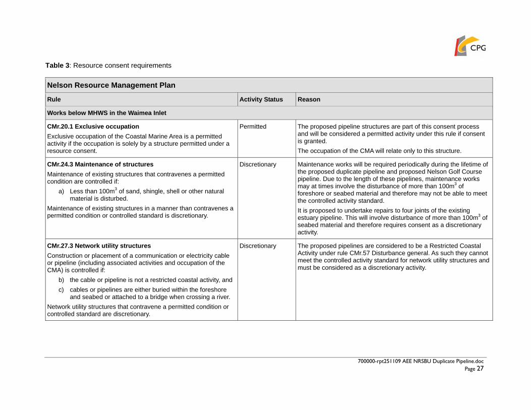
700000-rpt251109 AEE NRSBU Duplicate Pipeline.doc Page 27
Table 3: Resource consent requirements
Nelson Resource Management Plan
Rule Activity Status Reason
Works below MHWS in the Waimea Inlet
CMr.20.1 Exclusive occupation Exclusive occupation of the Coastal Marine Area is a permitted activity if the occupation is solely by a structure permitted under a resource consent.
Permitted The proposed pipeline structures are part of this consent process and will be considered a permitted activity under this rule if consent is granted. The occupation of the CMA will relate only to this structure.
CMr.24.3 Maintenance of structures Maintenance of existing structures that contravenes a permitted condition are controlled if:
a) Less than 100m3 of sand, shingle, shell or other natural material is disturbed.
Maintenance of existing structures in a manner than contravenes a permitted condition or controlled standard is discretionary.
Discretionary Maintenance works will be required periodically during the lifetime of the proposed duplicate pipeline and proposed Nelson Golf Course pipeline. Due to the length of these pipelines, maintenance works may at times involve the disturbance of more than 100m3 of foreshore or seabed material and therefore may not be able to meet the controlled activity standard. It is proposed to undertake repairs to four joints of the existing estuary pipeline. This will involve disturbance of more than 100m3 of seabed material and therefore requires consent as a discretionary activity.
CMr.27.3 Network utility structures Construction or placement of a communication or electricity cable or pipeline (including associated activities and occupation of the CMA) is controlled if:
b) the cable or pipeline is not a restricted coastal activity, and c) cables or pipelines are either buried within the foreshore
and seabed or attached to a bridge when crossing a river. Network utility structures that contravene a permitted condition or controlled standard are discretionary.
Discretionary The proposed pipelines are considered to be a Restricted Coastal Activity under rule CMr.57 Disturbance general. As such they cannot meet the controlled activity standard for network utility structures and must be considered as a discretionary activity.

700000-rpt251109 AEE NRSBU Duplicate Pipeline.doc Page 28
CMr.31.1 Damage to or removal of vegetation Damage to or removal of vegetation is permitted if it is associated with activities authorised by way of a resource consent.
Permitted Resource consent is being sought for the installation of two pipelines under the bed of the Waimea Inlet and any damage or removal of vegetation will be directly related to this. As such consent is not specifically required for any damage to or removal of vegetation during construction of the pipelines.
CMr.33 Disturbance of foreshore or sea bed by vehicles Driving of vehicles on, and disturbance of, the foreshore or seabed by vehicles, is permitted if the activity is associated with the construction or placement of network utility structures undertaken under a permitted activity rule of the Proposed Plan, or authorised by way of a resource consent.
Permitted Resource consent is being sought for utility structures and any vehicular activity on the foreshore/seabed will be directly related to this. As such, consent is not specifically required for vehicular activity on the foreshore/seabed during construction of the pipelines.
CMr.35 Drilling Drilling activities that contravene a controlled standard are discretionary.
Discretionary As the final construction methodology has not yet been decided it is not known for certain whether any drilling will be required. Should directional drilling be selected as the preferred construction approach, discretionary activity consent will be required for the following reasons:
a) The drilling equipment would have a maximum diameter of more than 200mm; and
b) The drilling operation would be undertaken within the Marine ASCV Overlay.

700000-rpt251109 AEE NRSBU Duplicate Pipeline.doc Page 29
CMr.37.3 Disturbance general Disturbance of foreshore or seabed that
a) Is not dealt with specifically in other rules, or b) Contravenes a permitted condition or controlled standard in
this rule, is discretionary. Any activity involving the disturbance of foreshore or seabed within the estuaries, other than maintenance work on existing roads, is a non-complying activity. In addition, any activity involving the disturbance of foreshore or seabed, including any removal of sand, shell, or shingle in any 12 month period:
c) in volumes greater than 50,000 m3; or d) extracted from areas equal to or greater than 4ha, or e) extending 1,000m or more over foreshore or seabed
is a restricted coastal activity.
Non-complying and Restricted Coastal Activity
Installation of the proposed pipelines will involve the disturbance of the seabed that is already a discretionary activity pursuant to rule CMr.27. However, as the proposed works are located within an estuary they must be considered as a non-complying activity under rule CMr.37.3. Furthermore, the works will require the disturbance of the foreshore and seabed of the Waimea Inlet over a distance of more than 1,000 metres and over an area of approximately 4.8 ha. Consequently the proposal must also be treated as a Restricted Coastal Activity.
CMr.56 Construction noise Noise levels generated by construction, maintenance or demolition work, measured at, or within any Residential Zone must not exceed the standards set out in NZS 6803P:1984, “The measurement and assessment of noise from construction, maintenance or demolition work”. Activities that contravene this condition are discretionary.
Permitted It is anticipated that noise generated during the construction period will be within the standards set out in NZS 6803P:1984.
Works above MHWS on Saxton Island
RUr.25 Vegetation clearance Vegetation clearance is a permitted activity if it does not take place within 20m of the Coastal Marine Area, except for the installation and maintenance of utility service lines including the excavation of holes for supporting structures, back-filled trenches, mole ploughing or thrusting, providing the clearance is no more than is required to permit the activity.
Permitted Some limited vegetation clearance may be required above the level of MHWS on Saxton Island. Any such works would be located within 20m of the Coastal Marine Area. Given the works are for the purpose of installing a utility service line they are permitted under rule RUr.25.

700000-rpt251109 AEE NRSBU Duplicate Pipeline.doc Page 30
RUr.26 Soil disturbance Soil disturbance is a permitted activity if it does not take place within 20m of the Coastal Marine Area, except for the installation and maintenance of utility service lines including the excavation of holes for supporting structures, back-filled trenches, mole ploughing or thrusting, providing the disturbance is no more than is required to permit the activity.
Permitted Some limited soil disturbance may be required above the level of MHWS on Saxton Island. Any such works would be located within 20m of the Coastal Marine Area. Given the works are for the purpose of installing a utility service line they are permitted under rule RUr.26.
RUr.27 Earthworks Earthworks are a permitted activity if they do not take place within 20m of the Coastal Marine Area, except for the purpose of installation and maintenance of utility service lines including the excavation of holes for supporting structures, back-filled trenches, mole ploughing or thrusting, providing the disturbance is no more than is required to permit the activity.
Permitted Some limited earthworks may be required above the level of MHWS on Saxton Island. Any such works would be located within 20m of the Coastal Marine Area. Given the works are for the purpose of installing a utility service line they are permitted under rule RUr.27.
RUr.53.2 Coastal Environment Overlay Earthworks Earthworks which contravene a permitted condition are controlled if they are not located within the Land Management Overlay and the maximum height or depth of excavation or filling does not exceed 3m.
Controlled Some limited earthworks associated with the construction works may extend above the level of MHWS in the vicinity of the easternmost air valve on Saxton Island. Any such earthworks would require consent as a controlled activity under RUr.53.2 as they would not exceed a maximum depth of 3m and would not be located within a Land Management Overlay area.
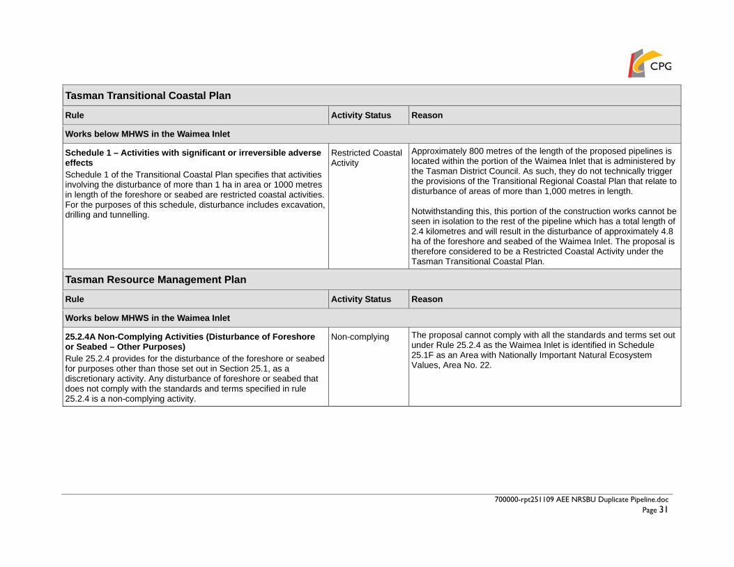
700000-rpt251109 AEE NRSBU Duplicate Pipeline.doc Page 31
Tasman Transitional Coastal Plan
Rule Activity Status Reason
Works below MHWS in the Waimea Inlet
Schedule 1 – Activities with significant or irreversible adverse effects Schedule 1 of the Transitional Coastal Plan specifies that activities involving the disturbance of more than 1 ha in area or 1000 metres in length of the foreshore or seabed are restricted coastal activities.For the purposes of this schedule, disturbance includes excavation, drilling and tunnelling.
Restricted Coastal Activity
Approximately 800 metres of the length of the proposed pipelines is located within the portion of the Waimea Inlet that is administered by the Tasman District Council. As such, they do not technically trigger the provisions of the Transitional Regional Coastal Plan that relate to disturbance of areas of more than 1,000 metres in length. Notwithstanding this, this portion of the construction works cannot be seen in isolation to the rest of the pipeline which has a total length of 2.4 kilometres and will result in the disturbance of approximately 4.8 ha of the foreshore and seabed of the Waimea Inlet. The proposal is therefore considered to be a Restricted Coastal Activity under the Tasman Transitional Coastal Plan.
Tasman Resource Management Plan
Rule Activity Status Reason
Works below MHWS in the Waimea Inlet
25.2.4A Non-Complying Activities (Disturbance of Foreshore or Seabed – Other Purposes) Rule 25.2.4 provides for the disturbance of the foreshore or seabed for purposes other than those set out in Section 25.1, as a discretionary activity. Any disturbance of foreshore or seabed that does not comply with the standards and terms specified in rule 25.2.4 is a non-complying activity.
Non-complying The proposal cannot comply with all the standards and terms set out under Rule 25.2.4 as the Waimea Inlet is identified in Schedule 25.1F as an Area with Nationally Important Natural Ecosystem Values, Area No. 22.

700000-rpt251109 AEE NRSBU Duplicate Pipeline.doc Page 32
Tasman Transitional Coastal Plan
Rule Activity Status Reason
25.1.6 Controlled Activities (Other Structures or Occupation) Any disturbance or occupation of the coastal marine area by or in connection with the use, maintenance, repair or removal of any pipe, discharge outfall structure, navigation aid, overhead line or with the upgrading of any overhead line, is a controlled activity if it complies with the following standards and terms:
a) The activity does not include the construction or installation of any facility in a new location;
b) The activity does not involve any additional support structure…
Controlled The proposed repair works to the existing estuary pipeline comply with all the standards and terms set out in Rule 25.1.6. This work is therefore considered to be a controlled activity.
Works above MHWS on Bells Island
16.6.2.1 Permitted Activities (Network Utilities and Public Works) Any upgrading of an existing facility or construction of a new facility for any network utility or public work, or any change in activity within an existing facility is a permitted activity that may be undertaken without a resource consent if it complies with conditions (a) through to (o).
Permitted The proposal involves the installation of a new wastewater pipeline above the level of MHWS on Bells Island. These works comply with all the conditions set out for network utility structures and are therefore considered to be a permitted activity.
18.1.6.1 Restricted Discretionary Activities (Construction of Building or Structure, Land Disturbance or Planting of Trees in relation to Archaeological Sites) The construction of any building or other structure, land disturbance, planting of trees, either on an archaeological site listed in Schedule 18.1D, or within a distance of 20 metres from the site, is a restricted discretionary activity.
Permitted Construction works on Bells Island will be undertaken at a distance of more than 20 metres from archaeological site N27/141, listed in Schedule 18.1D as TDC 16014. This work is therefore considered to be a permitted activity.

700000-rpt251109 AEE NRSBU Duplicate Pipeline.doc Page 33
Storage of construction materials on Rabbit Island
16.8.2.1 Temporary Activities Temporary activity ancillary or incidental to building and construction work limited either to the duration of the project or for a period not exceeding 12 months, whichever is the lesser.
Permitted Any use of Rabbit Island to store construction materials or for the welding of pipe strings would be limited to the duration of the construction period.
700000-rpt251109 AEE NRSBU Duplicate Pipeline.doc Page 34
8.0 ASSESSMENT OF EFFECTS
8.1 Overview This assessment has been prepared in accordance with the requirements of section 88(2)(b) and the Fourth Schedule of the Resource Management Act 1991 (“the Act”). Section 88 requires any application for resource consent to include an assessment of environmental effects in such detail that corresponds with the scale and significance of the effects the activity may have on the environment. To assess the actual and potential effects of the proposed pipeline, several specialist studies have been undertaken. These studies have considered the effects of the works on the cultural, social, ecological and economic environment and are included as appendices to this report.
8.2 Sediments in the Estuary The composition of estuary substrates varies as the pipeline route crosses from the hard-packed beach and intertidal areas of Monaco Peninsula, Saxton Island and Bells Island through the softer sediments of the estuary channels. The excavation of a pipeline trench or to a lesser extent the use of a mole ploughing device to install the proposed pipeline will disturb sediments in the estuary, particularly soft benthic sediments, causing them to suspend in the water column. Ecological implications of sediment suspension include:
• The effects of re-deposition/relocation of the suspended material on benthic communities;
• The release of nutrients and/or significant amounts of organic material into the water column; and
• The decrease in light available to aquatic algae and plants due to the suspension of sediments in the water column.
In this case, the effects of sediment suspension are expected to be minimal. This is because the level of resuspension from construction of the pipeline will be relatively small and localised in extent. In addition, the rapid tidal flows of the Waimea Inlet will quickly disperse sediment plumes and flush the bulk of suspended sediments out of the estuary. The natural background turbidity levels of the estuary are relatively high due to the dynamic nature of tidal flows through the Inlet and suspended sediments will blend into background turbidity within a relatively short distance of the point of suspension. The Cawthron report notes that organisms in the Waimea Inlet are typically well adapted to the natural processes of sediment movement, erosion and deposition. In those parts of the estuary likely to be affected by sedimentation, fauna communities are particularly used to dynamic flow regimes and, as a result, are inherently tolerant to turbidity. The smothering of benthic communities by sediment accumulation is likely to be confined to within a few metres of the pipeline and will be limited to the duration of the construction period. As set out in the Cawthron report, recovery of faunal communities via migration and recruitment is expected to be rapid, in the order of weeks to months. Evidence of complete community and habitat recovery from the construction of the existing pipeline was noted during subtidal and intertidal surveys.

700000-rpt251109 AEE NRSBU Duplicate Pipeline.doc Page 35
8.3 Effects on Intertidal Biota The intertidal zones on Monaco Peninsula, Saxton Island and Bells Island were surveyed by the Cawthron Institute in August and September 2008. The survey found that intertidal biota in the vicinity of the pipeline route was generally typical of the Waimea Inlet as a whole. Eelgrass fields and sabellarid worm mounds were identified in the lower intertidal habitats off all three survey sites. While these features are found in other parts of the estuary, they are relatively less abundant and the populations found in the vicinity of the pipeline route were described in the report as having some ecological significance. Eelgrasses both require and help to maintain relatively stable substrates, while the sabellarid worm mounds were noted for their relative uniqueness in the areas surveyed. Both species are relatively sensitive to disturbance and the destruction of some patches of these communities would be unavoidable should the pipeline be installed by way of an open trenching or mole ploughing technique. The Cawthron report notes that the presence of healthy communities in the surrounding areas would aid in the process of re-establishment following the completion of construction works. The report concludes that provided the pipeline installation project is carefully managed to minimise physical disturbance to these areas, construction activities are not expected to result in significant or long-lasting ecological effects to the wider estuary area. Mechanical damage to intertidal areas adjacent to the eelgrass beds and sabellarid worm mounds will be minimised as much as possible by undertaking excavation works in these areas from barges rather than driving excavators out onto the estuary bed.
8.4 Effects on Subtidal / Benthic Biota Subtidal habitats were also surveyed by the Cawthron Institute in August and September 2008. Most benthic species along the proposed pipeline route were found to be common throughout the estuary and the temporary disturbance or destruction of species over this restricted area is not considered to be ecologically significant. A sponge garden located within the Monaco-Saxton channel is, however, considered to be of moderate ecological and scientific value. The sponge garden provides a complex and varied ecological habitat and is thought to be serving as a ‘seed population’ for other regions within the estuary. Sponge gardens are not widespread in the estuary but appear to be re-colonising certain areas, including the newly discovered sponge garden off Bells Island. As with the eelgrass beds and sabellarid worm mounds in the intertidal zones, the destruction of some patches of the sponge garden would be unavoidable should the pipeline be installed by way of an open trenching or mole ploughing technique. However, as set out in the Cawthron report, the garden has been shown to encompass a total area of approximately 4.8 ha and any disturbance would affect only a small proportion of its full extent. Construction activities will be managed to minimise mechanical damage to the sponge gardens as much as possible. It is significant to note that the subtidal survey of the Monaco-Saxton channel found sponges in the immediate vicinity of the existing pipeline, indicating that following installation disturbance, sponges will re-colonise the area. Should a dig and lay method be used, the trench would be backfilled with sediment removed during the pipeline construction, which will promote rapid re-colonisation because of its existing organic and microbial content. With respect to other benthic species, rapid re-colonisation of the disturbed sediments is expected. Mobile adults will move in from surrounding habitats within weeks or months and

700000-rpt251109 AEE NRSBU Duplicate Pipeline.doc Page 36
larval recruitment of new individuals to the restored construction zone will also contribute to the re-colonisation of the estuary bed above the pipeline in the following year. Damage to the benthic environment would be minimal if a trenchless or directional drilling method was used to install the pipeline.
8.5 Effects on Fish A diverse range of fish species are present in the Waimea Inlet with an identified total of 41 species (Directory of Wetlands in New Zealand). The characteristics of each species are slightly different meaning they will each be affected in different ways by the construction activities. Disturbance of the estuary bed during excavation of a trench and the associated noise of any sheet piling is likely to cause adult fish and mobile juveniles to swim away from the disturbance and use other parts of the estuary. Juvenile fish unable to swim away from the area of construction and the eggs of species that breed and lay in the estuary may be smothered if they are in the path of the pipeline trench or associated area of disturbance, a combined total of approximately 20 metres in width. However, as set out in section 8.2 of this report the effects of sediment loading are expected to be minimal. Sheet piling of the trench in deeper and softer parts of the estuary would assist in containing sediments within a confined area. These effects are short-term and specific to the construction period of the pipeline through the estuary. Once the pipeline has been laid, the trench will be filled and the estuary bed restored to its original topography. The pipeline trench would not block the mouth of the Waimea River and would not cause an obstruction of the flow of the river or to fish species migrating between the estuary and the river, such as short and long fin eels, brown trout and lamprey. If a trench is not excavated across the estuary, fish in the estuary will not be affected by the pipeline installation.
8.6 Effects on Birds The Waimea Inlet is widely used by a number of bird species, with the Bells Island shellbanks being a key nesting and roosting site for shore birds and migratory species. The pipeline will come ashore on Bells Island approximately 300 metres to the south of the shellbanks. It is acknowledged that there may be a temporary effect on birds during the construction period, however given the separation distance of 300m between the area of works and the shellbanks it is unlikely that construction activities and the associated noise will displace these species. In addition, if timing to minimise those effects can be reasonably achieved, for example by establishing the Bells Island construction site and undertaking pipeline installation at the Bells Island end after the nesting season finishes in April and before the birds come in to roost in early September. This will be considered as part of the Construction Management Plan. The dig and lay method of pipeline construction or the mole ploughing method will cut across minor feeding grounds. As set out in the Cawthron report, these are likely to recover in time as benthic invertebrates living in the estuary bed re-colonise the disturbed pipeline route. Construction activities will displace birds from feeding along the pipeline route. However this is a temporary disturbance and birds will be able to feed in other parts of the estuary until construction has finished and sediments have been recolonised. There will be no long term effects to bird species as a result of the construction activities.

700000-rpt251109 AEE NRSBU Duplicate Pipeline.doc Page 37
8.7 Effects on Saxton Island Vegetation There are substantial areas of undisturbed vegetation on the northern side of Saxton Island including fields of Stipa stipoides Needle Tussock in the vicinity of the existing and proposed air valves. This plant community stabilises coastal sediments that would otherwise be potentially mobile but is susceptible to compaction and trampling. In addition a plot of the critically threatened plant species Lepidium banksii Coastal Peppercress is located on the northeastern shoreline of the island in the vicinity of the eastern air valves. The proposed pipeline itself will be located in the intertidal zone and will not directly affect these areas of vegetation. However, care will need to be taken during construction works to avoid damage to the foreshore and areas above MHWS. At the eastern end of the island, the separation distance between the existing and proposed pipeline will be reduced to 5-6 metres to ensure the new pipe can be laid without disturbing the plot of Coastal Peppercress. Suitable precautions, such as fencing of the plot, will be implemented during construction works and specific reference to the plants will be included in the Construction Management Plan to ensure the contractor is aware of the need to implement appropriate management procedures in this location. Where possible, all machinery associated with construction works on Saxton Island will be operated and/or stored on barges. If access and/or storage on the island is necessary, this would need to be carefully managed and details agreed through discussions with the landowner and DOC. Some areas on the island, such as the road, are already heavily modified landscapes and would be more suitable for these activities. The use or disturbance of the areas of tussock adjacent to the existing and proposed air vents as shown on Sheet CO1 in Appendix B would be specifically avoided. Detailed information on the construction approach on Saxton Island will be included in the Construction Management Plan. This will include details of all site restrictions, a description of exactly how construction works will be carried out and how restoration works will be undertaken on completion of the construction phase. DOC has identified the presence of an invasive succulent species along the proposed pipeline route, which could potentially spread to other locations in the estuary as a result of disturbance during construction work. The extent of this weed is shown on Sheet CO1 in Appendix B. DOC proposes to undertake a spray eradication programme, as soon as they obtain resource consent, to remove the weed from the island. It is not known what stage of the process this eradication programme will have reached by the time construction works are ready to commence on the proposed pipeline project. As such, it is not known whether or not there will be a need to undertake precautionary measures to avoid the spread of the weed during the construction process. Such measures could involve a surface scrape prior to works commencing to remove all plant specimens from the construction area. This material could either be buried immediately or be stockpiled and backfilled into the trench at a depth that would prevent grow-back. Contact will be maintained with DOC to monitor the progress of the eradication programme and the need for management of the weed species through the construction phase. Should there be a need to implement precautionary measures during construction works the nature of such measures would need to be agreed with DOC prior to construction commencing.
700000-rpt251109 AEE NRSBU Duplicate Pipeline.doc Page 38
8.8 Assessment of Possible Effects on Tangata Whenua Cultural and Spiritual Values
The Cultural Impact Assessment (contained in Appendix D) outlines a number of concerns held by tangata whenua ki Whakatu in relation to the impact of the existing Nelson Regional Sewerage Scheme on the Waimea Inlet. These concerns relate primarily to:
• Loss of rangatiratanga – inability of tangata whenua to practise kaitiakitanga and protect the mauri and wairua of the Waimea Inlet;
• Desecration of mahinga kai (food gathering places) and waahi tapu (sacred places or sites) due to the location of the outfall pipeline in the Waimea Inlet;
• Loss of mana resulting from the inability to provide for guests from the local food basket; • Contamination of waahi tapu from the discharge of sewerage (treated and untreated); • Risk of the destruction of waahi tapu due to the development of estuary margins; and • Loss of traditional resources and associated matauranga.
As a result, tangata whenua do not support the placement of a duplicate wastewater pipeline across the estuary and consider that the proposal will have further impacts on cultural and spiritual values. Iwi acknowledge, however, that any work which might be undertaken at a broader scale to improve the health of the estuary would be in vain if the existing estuary pipeline was to rupture and spill untreated sewage directly into the Waimea Inlet. As no other viable options have been identified to deal with the immediate threat of failure of the existing pipeline, the tangata whenua ki Whakatu working group has advised they are prepared to compromise and accept the proposed duplicate pipeline. Subsequent to issue of the CIA in August 2008, iwi representatives have advised that they will no longer insist on the removal or decommissioning of the duplicate pipeline within 10 years, but that following installation of the new pipeline, the NRSBU should continue to look seriously at other alternatives for a long term solution. This is set out in the minutes of a meeting of the NRSBU held on 17 April 2009 and attended by representatives of the local iwi, which are included in Appendix G. Work is continuing on identifying options for the long-term upgrade of the Nelson Regional Sewerage Network as a whole and the selection of a preferred option may still be some way off. In order to mitigate adverse effects on waahi tapu during construction of the proposed duplicate pipeline, iwi have requested that:
• An iwi monitor is present for all earthworks undertaken on Bells Island, Saxton Island and Monaco Peninsula;
• That further archaeological work is undertaken to investigate the extent of N27/141 on Bells Island and that the duplicate pipeline is positioned to avoid archaeological sites N27/136 and N27/141.
Further archaeological work has already been undertaken to investigate the extent of N27/141 on Bells Island, as detailed in section 8.9 below, and it is proposed to invite an iwi representative to be present on site during all excavation in these locations. With respect to the proposed secondary pipeline to convey treated wastewater from the Bells Island treatment plant to the Nelson Golf Club, iwi have advised they are prepared to agree to this activity as it is a good use of wastewater as a resource rather than discharging it to the estuary.
700000-rpt251109 AEE NRSBU Duplicate Pipeline.doc Page 39
In the case of both pipelines, iwi have requested support for the monitoring and improvement of the health of the Waimea Estuary and associated coastal area. These activities will form part of the ongoing work being undertaken by the NRSBU in relation to the long-term upgrade strategy. Aside from this process, the NRSBU is investigating the feasibility of establishing a dedicated group to monitor/plan the health of the estuary.
8.9 Assessment of Possible Effects on Archaeological Sites An archaeological assessment of the effects of the proposed duplicate pipeline was undertaken by archaeologist Deb Foster in August 2008 (contained in Appendix E). The report concludes that on Bells Island, the new pipeline could be laid up to 20 metres to the south of the existing line with relatively little impact on the archaeological site N27/141 located at the southeastern corner of the island. As shown on Sheet C01 contained in Appendix B, a separation distance of more than 20 metres will be maintained between the proposed pipeline and the northernmost extent of N27/141. As such, it is considered that the proposal will have minimal effect on N27/141. This plan also shows that the duplicate pipeline will pass more than 100 metres away from the archaeological site N27/136 located at the eastern end of Saxton Island. As such it is considered unlikely that the pipeline will adversely affect this archaeological site. Notwithstanding this, there is a possibility that undisturbed archaeological deposits exist in the vicinity of both sites, N27/141 and N27/136 and it is recommended that an iwi representative and an archaeologist be invited to monitor all excavations in these areas.
8.10 Assessment of Possible Effects of Pipeline Construction on Social and Economic Environment
The effects of construction activities on the social and economic environment will involve logistical disruption, noise generation, the generation of dust, sand mobilisation and increased traffic on the Monaco Peninsula. These effects are likely to be significant but time restricted and mitigation strategies will be employed to reduce effects.
8.10.1 Disruption to Traffic Flows During the construction of the pipeline from the end of Monaco Peninsula to Saxton Island there will be disruption to normal traffic flows along Point Road and Martin Street. A section of Point Road at the western tip of the peninsula near the junction with Martin Street will be closed for a period of time during construction works. This will prevent vehicles from driving around the end of the peninsula, however access is available to both sides of the peninsula via Point Road and Martin Street and to either side of the peninsula via Rainier Street and there will be only a minor diversion to access the end of the peninsula. At no point will any resident be unable to access their property, except by prior arrangement for limited periods of time. A Traffic Management Plan will be produced in accordance with the Code of Practice for Temporary Traffic Management (COPTTM), prior to the start of construction. During construction, an appropriate traffic flow system will be put into effect. As part of the construction operation a site foreman will be on site to deal with all issues and answer any immediate questions from residents or members of the public. Depending on the pipeline installation method, it is anticipated that pipe laying will involve up to 20 truck movements per day. A trenchless / directional drilling approach requiring the removal of excavated material from the site may involve up to 20 truck movements per day whereas a dig and lay or mole ploughing technique would require much fewer vehicle movements, as these approaches would not require the removal of material from the site.

700000-rpt251109 AEE NRSBU Duplicate Pipeline.doc Page 40
There will be minimal car vehicle movements involved in the project, with approximately 20 – 30 movements per day to the construction area at Monaco Peninsula. Truck movements to the end of the peninsula will be more intense during delivery of pipe sections, to be stored in the foreshore area. It is also possible that the boat ramp at Point Road will be used to load barges for transporting pipe sections to other storage locations in the estuary. In this case, the number and duration of truck movements to the peninsula would increase. These effects will be temporary and will be limited to the construction phase of the project.
8.10.2 Noise The level of noise generated during the construction period will be dependent on the final construction methodology, which is to be determined through the tender process. The appropriate criteria relating to construction noise levels are set out in NZS6803:1999 Acoustics – Construction Noise. This standard also forms the permitted activity standard in the NRMP for construction work in the Coastal Marine Area, albeit the older 1984 version of the standard is referenced in the NRMP. The construction noise standard makes allowance for higher noise levels associated with construction work on the basis that the work is temporary in nature. Noise limits are set by time of day with noisy work limited to the hours of 0730 – 1800 and shoulder periods provided between the hours of 0630 – 0730 and 1800 – 2000. In this case, there will be a requirement to vary working hours over the length of the construction period in response to tidal processes. Some construction activities can only be undertaken in low tide conditions and in the interests of minimising the overall construction timeframe, it is proposed to undertake some works during the night time period where this coincides with low tides. The construction process will be managed to ensure the noisiest activities are restricted to daytime hours only and it is anticipated that noise generated during construction works will be within the limits set by the above standards. It is noted that as the activities move progressively across the estuary they will be located further and further away from the residents of Monaco Peninsula and the level of noise experienced on the peninsula will reduce. A Noise Management Plan will be prepared once the final construction approach has been determined setting out the mitigation measures that will be followed in the project. It is considered that with appropriate community liaison, the implementation of mitigation measures and a requirement that the contractor utilise the quietest available techniques, noise levels can be kept within acceptable limits.
8.10.3 Sand and Dust During the construction phase of the project as the pipeline trench is excavated, an amount of sand and dust will become mobile and may be carried through the Monaco Peninsula area. As the majority of the pipeline will be located below the level of MHWS, the majority of excavations will involve wet materials. This will minimise the likelihood of wind-blown dust.
8.10.4 Safety of Residents To ensure the safety of residents and workers during pipeline construction, risk assessments will be produced for each stage of the project and all appropriate measures put in place to remove the potential for accident. A Risk Assessment and Health and Safety Plan will be produced by the contractor prior to the start of operations. As part of health and safety planning, members of

700000-rpt251109 AEE NRSBU Duplicate Pipeline.doc Page 41
the public will be restricted from entering construction areas during the construction phase of the project. There will be no increased risk to the safety of residents during the construction activities.
8.10.5 Restriction of Recreation and Loss of Amenity Values During the construction phase of the project, access for walkers to the beach and foreshore at the western end of the Monaco Peninsula will be restricted. Walking access will continue to be available along Point Road even where vehicle access is restricted. As construction work is completed access will be restored around the end of the peninsula. In addition, the Point Road boat ramp may be used to transport pipe sections, construction equipment and personnel to construction sites on Saxton Island and other parts of the estuary. This will result in more limited availability of the boat ramp for use by members of the public. In addition, as the pipeline is laid across the estuary, access will be restricted to boaters and water sports users in the affected area. Individuals wishing to utilise these areas will be temporarily displaced, however the construction activities will never completely occupy the channels on both sides of Saxton Island at any one time and alternative routes to access other parts of the estuary and Tasman Bay will always be available. Communication will be maintained with the Harbourmaster, who will be involved in the imposition of any temporary restrictions. This displacement effect will be limited to the construction phase of the project and specific to each area, dependent on the progress of construction.
8.10.6 Landscape and Natural Character Values There will be some level of disruption to the landscape and natural character values of the area as a result of the duplicate pipeline project. The majority of these effects will be limited to the duration of the construction phase and will be temporary in nature. During installation of the pipeline, care will be taken to avoid the most sensitive landscape features such as the riparian vegetation communities on Saxton Island. Access to the areas of vegetation adjacent to the air valves on Saxton Island will be restricted, as illustrated on Sheet CO1 in Appendix B, to ensure these plant communities are not affected. Likewise, a coastal buffer area would be established on Rabbit Island to protect sensitive coastal habitats, should there be a need to use the island for storage or pipe welding activities. This exclusion area is illustrated on Sheet CO1 in Appendix B. All construction works will be undertaken in accordance with a Construction Management Plan, which will set out details including:
• The type of construction method to be adopted. • Detailed information about transport and storage of materials and machinery throughout
the estuary. • A construction programme including timetable, sequence of events, hours of operation
and duration. Once the final construction approach has been determined, a restoration plan will be prepared taking into account the recommendations set out in the Tasman Carter Landscape Report, contained in Appendix F. On Bells Island, it is proposed to reinstate those areas that are directly affected by the construction works. No further planting work is proposed as land in the vicinity of the pipeline route forms part of the operational area of the wastewater treatment plant and is used to store materials associated with the treatment plant and as an access point to the estuary.

700000-rpt251109 AEE NRSBU Duplicate Pipeline.doc Page 42
The only visible effects on completion of the works will be the presence of an additional manhole cover to match the existing one adjacent to Point Road on the Monaco Peninsula and the additional rising mains adjacent to the existing structures within the intertidal area of Saxton Island. Within the context of the wider estuary environment, the visual effects of these new structures are considered to be negligible.

700000-rpt251109 AEE NRSBU Duplicate Pipeline.doc Page 43
9.0 OBJECTIVES AND POLICIES
9.1 Overview There are five policy documents containing objectives and policies relevant to this application. These are:
• New Zealand Coastal Policy Statement (NZCPS) • Nelson Regional Policy Statement (NRPS) • Tasman Regional Policy Statement (TRPS) • Nelson Resource Management Plan (NRMP) • Tasman Resource Management Plan (TRMP)
9.2 New Zealand Coastal Policy Statement The New Zealand Coastal Policy Statement 1994 (NZCPS) provides policy guidance to local authorities in their day to day management of the coastal environment. The NZCPS is currently under review. A draft revised NZCPS has been prepared and was notified in 2008. Hearings have been completed but no recommendations have yet been released from the Board of Inquiry. Consequently, the 1994 NZCPS remains the document with effect in planning terms. The relevant objectives and policies of the NZCPS relate to use and development of the coastal environment and preservation of the natural character of the coastal environment. Chapter 1 Chapter 1 and policies 1.1.1 to 1.1.5 are directed at providing for the preservation of the natural character of the coastal environment and giving protection from inappropriate subdivision, use and development. Policy 1.1.1 It is a national priority to preserve the natural character of the coastal environment by:
(a) encouraging appropriate subdivision, use or development in areas where the natural character has already been compromised and avoiding sprawling or sporadic subdivision, use or development in the coastal environment;
(b) taking into account the potential effects of subdivision, use or development on the values relating to the natural character of the coastal environment, both within and outside the immediate location; and
(c) avoiding cumulative adverse effects of subdivision, use and development in the coastal environment.
On completion of the construction works, the site will be rehabilitated and the pipeline will be buried beneath the bed of the estuary where it will not be visible. The only visible structures will be the two new air valves on Saxton Island and the new manhole at the end of Monaco Peninsula. As such, it is considered that the proposed pipeline will have limited adverse effects on the natural character of the coastal environment. Policy 1.1.2 It is a national priority for the preservation of the natural character of the coastal environment to protect areas of significant indigenous vegetation and significant habitats of indigenous fauna in that environment by:
(a) avoiding any actual or potential adverse effects of activities on the following areas or habitats:

700000-rpt251109 AEE NRSBU Duplicate Pipeline.doc Page 44
(i) areas and habitats important to the continued survival of any indigenous species; and
(ii) areas containing nationally vulnerable species or nationally outstanding examples of indigenous community types;
The Waimea Inlet is identified as an area with nationally vulnerable species and areas and habitats important to the survival of indigenous species. However, the duplicate pipeline will follow the route of the existing estuary pipeline thus restricting works to an area that has previously been exposed to some level of disturbance. The pipeline route avoids those areas of the estuary, such as salt marsh communities on the estuary margins, with the highest conservation values. The proposal will result in short term disturbances during the construction period. However the long term effect on the coastal environment is considered no more than minor. Policy 1.1.3 It is a national priority to protect the following features, which in themselves or in combination, are essential or important elements of the natural character of the coastal environment:
(a) landscapes, seascapes and landforms, including: (i) significant representative examples of each landform which provide the variety in
each region; (ii) visually or scientifically significant geological features; and (iii) the collective characteristics which give the coastal environment its natural
character including wild and scenic areas; (b) characteristics of special spiritual, historical or cultural significance to Maori identified
in accordance with tikanga Maori; and (c) significant places or areas of historic or cultural significance.
The Inlet is the largest example of a barrier enclosed estuary in the South Island and is a nationally important example of this type of natural feature. The project is considered to be consistent with this principle as the proposed pipeline will be buried under the bed of the estuary and will not affect the integrity of the landform. Known archaeological sites in the vicinity of the existing estuary pipeline have been surveyed and the route of the pipeline has been selected to avoid disturbing any such sites of cultural significance. Policy 1.1.4 It is a national priority for the preservation of natural character of the coastal environment to protect the integrity, functioning, and resilience of the coastal environment in terms of:
(a) the dynamic processes and features arising from the natural movement of sediments, water and air;
(b) natural movement of biota; (c) natural substrate composition; (d) natural water and air quality; (e) natural bio diversity, productivity and biotic patterns; and (f) intrinsic values of ecosystems.
Construction activities associated with installation of the pipelines are likely to have a temporary effect on the natural character of the area. However such effects will be short term. It is proposed to adopt best practise approaches, which will be confirmed by way of a detailed Construction Management Plan to ensure adverse effects are avoided, remedied or mitigated wherever possible. All construction areas will be restored on completion of the works.
700000-rpt251109 AEE NRSBU Duplicate Pipeline.doc Page 45
Policy 1.1.5 It is a national priority to restore and rehabilitate the natural character of the coastal environment where appropriate. All areas of the estuary disturbed by construction works will be rehabilitated on completion of the works. The future use of the existing pipeline will depend on the long-term upgrade strategy for the regional sewerage network as a whole. Options include complete decommission and removal, or the repair and reinstatement of the existing pipeline to provide improved capacity at a regional level. Investigations are continuing to determine the preferred options for this long-term strategy.
9.3 Nelson Regional Policy Statement The Regional Policy Statement (RPS) was made operative in March 1997 and sets out how the Nelson City Council will achieve integrated management of the significant resource management issues of the area. It includes general principles by which the Council will be guided in making decisions on these issues, and how the Council will address cross boundary issues with the wider community interest. The Councils 2007 review of the RPS has been indefinitely postponed and the 1997 RPS remains the operative document for consideration. The RPS acknowledges the enclosed coastal waters of the city including the Waimea Inlet as nationally significant features, vulnerable to change and requiring appropriate protection. It recognises that given the high and diverse values associated with the coastal environment, the potential exists for significant conflict between uses and values. Chapter 5 – Treaty of Waitangi Objective TW1.4.1 is to achieve resource use which provides for the relationship of tangata whenua with their ancestral lands, water and sites, waahi tapu, urupa and other taonga. Policy TW1.5.4 provides for matters stated to be of significance to tangata whenua, including cultural and archaeological sites. As set out in Section 10.5 of this report the applicant has consulted with tangata whenua and acknowledges the significant compromise that the tangata whenua ki Whakatu working group is accepting to their cultural values in agreeing to the pipeline proposals. The proposed duplicate pipeline is considered to be the only viable short term solution to safeguarding against failure of the existing estuary pipeline and the associated spillage of raw sewage into the estuary waters. The route of the pipeline has been aligned to avoid disturbing known archaeological sites within the estuary. Overall it is considered that these objectives and policies will not be infringed by the proposal. Chapter 8 – Management of the Coastal Environment This chapter sets out objectives and policies relating to the management of the region’s coastal environment. Objective CO1.2.1 Achievement of the social, economic and cultural needs of the community within the coastal environment, while ensuring a high level of protection is afforded to the natural character and to natural and physical resources associated with the coast.

700000-rpt251109 AEE NRSBU Duplicate Pipeline.doc Page 46
Policy CO1.3.2 seeks to achieve this objective by avoiding or remedy the effects of land uses or activities inland or within the coastal area and Policy CO1.3.4 seeks to protect the integrity, functioning and resilience of the coastal environment. The proposed works will be undertaken in a part of the estuary that has already been modified by residential development as well as the existing wastewater treatment plant and pipeline infrastructure. As set out in the report prepared by the Cawthron Institute (Appendix C) the effects of the proposed pipeline on the ecology of the coastal environment will be limited to localised areas, short in duration and will not have a long lasting effect. This is because local ecosystems are resilient and will recover quickly from the construction of the pipeline. The pipeline will be buried beneath the bed of the estuary and will not have a long term affect on coastal processes such as tidal flows and sediment transportation. Policy CO1.3.7 seeks to maintain and enhance public access to and along the Coastal Marine Area and Policy CO1.3.9 seeks to recognise and provide for matters of special significance to tangata whenua identified and protected in accordance with tikanga Maori. Public access to Point Road and the foreshore of Monaco Peninsula will be temporarily restricted during construction works to protect public health and safety.
9.4 Tasman Regional Policy Statement The Tasman Regional Policy Statement was made operative on 1 July 2001. The purpose of the document is to promote the sustainable management of natural and physical resources by providing an overview of the resource management issues of the region and setting out policies and methods to achieve integrated resource management. Objective 9.5 seeks to preserve the natural character of the coastal environment, including the functioning of natural processes. Policy 9.6 seeks to preserve the natural character of the coastal environment by protective natural features and landscapes, habitats, ecosystems, natural process and water and air quality. Once installed, the proposed pipeline will not be visible and the works will have only short term effects on the natural character of the Waimea Inlet. As set out in the Cawthron Institute Report (Appendix C), effects on the habitats and biota of the Inlet will be short term and these features will quickly recover to existing levels. It is proposed to manage all construction works so as to minimise adverse effects on the Waimea Inlet. The duplication and repair of the existing wastewater pipelines will provide for a more sustainable use of the regional sewerage infrastructure while minimising the risk of spills to the coastal marine area. Objective 9.6 and Policy 9.7 seeks to ensure that development of coastal land avoids, remedies or mitigates adverse effects on natural character, public access, amenity values, heritage values, Maori traditional associations and the natural qualities of coastal waters. The Tasman Regional Policy Statement recognises the Waimea Inlet as being of national importance. The Inlet possesses many coastal values relating to its natural character, coastal habitats and ecosystems and Maori cultural values.

700000-rpt251109 AEE NRSBU Duplicate Pipeline.doc Page 47
In order to ensure the effects of the proposal on these coastal values are avoided, remedied or mitigated, a Construction Management Plan will be implemented. This will set out full details of the construction approach and require adoption of best practice construction techniques. Objective 9.7 seeks the maintenance and enhancement of coastal water quality to provide for the needs of marine ecosystems and for sustainable public uses and values. Construction works will result in a short term increase in suspended sediments in the estuary waters. However these will quickly disperse with the natural tidal processes of the estuary. In the long term, the proposal will result in a reduced threat of sewage spills to the estuary, thus protecting the quality of the coastal waters. Objective 9.8 seeks to maintain public access to and along the coast while Policy 9.2 seeks to minimise navigation and safety risks. Public access to parts of the foreshore of Monaco Peninsula will be restricted during construction works in the interests of protecting public safety. However the proposal will not result in any long term effects on public access to the coast. Any need to regulate recreational boating in the vicinity of the pipeline route during construction works will be managed in consultation with the Harbour Master.
9.5 Nelson Resource Management Plan The Nelson Resource Management Plan recognises the Waimea Inlet as a Marine Area of Significant Conservation Value. Relevant objectives and policies are set out in chapter 13 of the plan. Chapter 5 – District Wide Objectives and Policies Objective DO1.1 states: management of natural and physical resources that recognise the needs of Maori communities and enables them to provide for their social economic, and cultural well being and their health and safety. It is acknowledged that conveyance of human waste through the coastal waters of the Waimea Inlet is considered to be culturally inappropriate by local iwi. However in this case, the proposed duplicate pipeline is considered preferable to the alternative of an uncontrolled spill of untreated sewage into the estuary, should the existing pipeline fail. Chapter 13 - Coastal Marine Area Objective CM1 supported by Policy CM1.1 seeks to maintain and enhance the life-supporting capacity of coastal ecosystems. The installation of the proposed duplicate pipeline will have a number of short term effects on the immediate estuary environment. Specifically, the disturbance of the estuary bed, suspension of sediment and the loss of flora and fauna within the construction zone. These adverse effects will be limited to the construction period. Following the completion of works and reinstatement of the site, ecosystems are expected to quickly return to the area. Policy CM1.2 seeks to avoid the adverse effects of subdivision, use and development in the coastal environment. Complete avoidance of works in this part of the estuary is not practicable as immediate action is necessary to avoid the threat of failure of the existing wastewater pipeline. The effects of such a

700000-rpt251109 AEE NRSBU Duplicate Pipeline.doc Page 48
failure on the coastal environment would be uncontrolled and are considered to be worse than any short term effects of installing the proposed duplicate pipeline on the estuary environment. Best practice construction techniques will be adopted to ensure the adverse effects of the construction works are effectively mitigated. It is considered that the scale of the proposed works and their overall character is such that any adverse effects can be adequately mitigated or remedied by the imposition of appropriate conditions. Objective CM2 together with Policy CM2.1 seek to preserve the natural character of the coastal environment and avoid the adverse effects of subdivision, use and development. The margins of the estuary have largely been developed and the Inlet itself has been modified by major infrastructure features such as the Bells Island wastewater treatment plant. However the northern side of Saxton Island is in a relatively undeveloped state and has a significant level of natural character. Once construction works are completed, the proposed pipeline will not be visible and the proposal will not have any long term adverse effect on the natural character of the coastal environment, nor will it affect the land/sea interface. As set out in the AEE, care will be taken to minimise any adverse effects during the construction process and details of the construction approach will be set out in a Construction Management Plan. Objective CM3 seeks to protect areas of significant indigenous vegetation, indigenous fauna and outstanding natural features. This objective is to be implemented through Policies CM3.1, CM3.2, CM3.3 and CM3.5, which seek to avoid the adverse effects of development on vegetation, fauna, habitats and marine areas of significant conservation value. Three features have been identified in the Cawthron report, contained in Appendix C, as having significant ecological value, eelgrass, sabellarid tubeworms and sponge gardens. These represent only small areas within or adjacent to the construction area in the bed of the estuary. Provided the pipeline installation project is carefully managed, the Cawthron Institute anticipate no significant or long-lasting effects to these populations. Best practice construction techniques will be adopted and details of the construction approach will set out in a comprehensive Construction Management Plan once a contractor is appointed to the project. At Saxton Island riparian vegetation will be protected from construction effects including compaction and trampling. The proposed Construction Management Plan and Restoration Plan will ensure these values are protected and enhanced. Policy CM4.5 seeks to ensure activities within the Coastal Marine Area do not interfere with navigation. There may be some short term disruption to recreational and navigation activities during the construction period. However, at no stage will vessels be prevented from travelling between the Martin Point jetty, the Waimea Inlet and out into Tasman Bay. Communication will be maintained with the Harbourmaster who will be involved should there be a need for any temporary diversions of vessels. Policy CM8.4 seeks to ensure that structures within the Coastal Marine Area do not interact with or intercept sediment flow in a way that could increase the risk of coastal erosion or accretion.

700000-rpt251109 AEE NRSBU Duplicate Pipeline.doc Page 49
The proposed pipeline will be buried beneath the bed of the estuary and will not affect sediment flow in any way. Under Policy CM8.5 disturbance of the foreshore or seabed should not remove such quantities of sediment from the onshore-offshore or longshore drift systems as to increase the risk of coastal erosion or accretion. The installation of the proposed pipeline will not require the removal of sediment from the foreshore or seabed. The construction area will be reinstated following completion of works.
9.6 Tasman Resource Management Plan Relevant objectives and policies are set out in Chapters 5, 8 and 21 of the Tasman Resource Management Plan. The provisions in these chapters closely reflect the requirements of the NZCPS. The objectives and policies of the TRMP relate to the proposed works on Bells Island, Rabbit Island and along the western portion of the pipeline route under the bed of the estuary. Policy 5.1.3.12 seeks to protect the natural character of coastal land from adverse effects of further subdivision, use or development. In the long term, the completed pipeline will not have a negative impact on the biota along the pipeline route or the natural functioning of ecological systems within the estuarine sediments Objective 8.1.1 seeks the maintenance and enhancement of public access to and along the margins of lakes, rivers, wetlands and the coast, which are of recreational value to the public. Public access to Bells Island is limited due to the presence of the wastewater treatment plant. The proposed duplicate pipeline will not result in any further restriction on public access. Objective 21.1.0 seeks to preserve the natural character of the coastal marine area and Policy 21.1.1 seeks to avoid, remedy or mitigate adverse effects of activities on the natural character of the coastal marine area. A Construction Management Plan will be prepared to ensure best practice construction techniques are adopted to mitigate adverse effects on the natural character of the coastal environment. Access will be restricted to areas of significant natural value on Rabbit Island, should this area be required for the storage of construction materials. Policy 21.1.3 seeks to restrict the placement of structures in or along the coastal marine area to those for which a coastal location is necessary. The proposal is considered to be consistent with this policy as there is an immediate need to address the risk of failure of the existing pipeline and the resultant spill of untreated sewage into the Waimea Inlet. In this case, there are no other viable alternatives to the current proposal to construct a duplicate pipeline through the estuary.
9.7 Conclusion As detailed in table 4 below, it is considered that the proposed works, overall, are consistent with the objectives and policies of the NZCPS, the Nelson and Tasman RPS, the Nelson Resource Management Plan and the Tasman Resource Management Plan. Specifically the proposal will provide for the continued social and economic wellbeing of the Nelson and Tasman communities by providing a sustainable sewerage network while reducing the threat of

700000-rpt251109 AEE NRSBU Duplicate Pipeline.doc Page 50
significant adverse effects on the coastal environment should the existing pipeline fail. Construction works will be undertaken in accordance with best practice approaches in order to avoid, remedy or mitigate any adverse environmental effects.

700000-rpt251109 AEE NRSBU Duplicate Pipeline.doc Page 51
10.0 CONSULTATION The NRSBU has undertaken initial consultation with a number of potentially affected parties prior to lodgement of this resource consent application. The consultation process has been worthwhile in that NRSBU representatives were able to demonstrate why the duplicate pipeline is necessary and were also able to better understand the concerns of affected parties. The consultation process is on going and it is the intention of the NRSBU to keep the public and stakeholder groups informed of progress for the duration of the consent process and throughout the construction of the pipeline.
10.1 Initial Consultation Initial consultation on the duplicate pipeline project was undertaken alongside consultation on the long term options for the Regional Pipeline Upgrade Strategy. There were three phases to this consultation – submissions were invited on a public consultation document; a hearing of submitters was held; and a telephone survey was undertaken. Subsequent to this, a meeting with iwi was held on 17 April 2009 to discuss the duplicate pipeline project in more detail. Further discussions have also been undertaken with the Department of Conservation, the Ornithological Society of New Zealand and the owners of Saxton Island in relation to the proposed duplicate pipeline.
10.2 Public Consultation Document To help the NRSBU determine a preferred long term strategy for the upgrading the regional sewerage network a Public Consultation Document was prepared and publicised in December 2008. The document presented the background information that underpins both the short term need for a duplicate pipeline across the estuary and the long term options for upgrading the regional sewerage network as a whole. A copy of the consultation document is contained in Appendix H. Sixty submissions were received during the consultation period, which ended on 27 February 2009. Questions on the submission form sought feedback primarily on the long term options for upgrading the regional sewerage network and an analysis of these submissions is presented in Appendix I. In relation to the duplicate pipeline proposal, the consultation document was useful in publicising the risk of failure of the existing pipeline and the need for immediate action to avoid the resultant uncontrolled discharge of raw sewage into the Waimea Inlet. Feedback from the consultation has assisted in identifying key environmental, economic, social and cultural concerns, such as the significance of the bird nesting areas at Bells Island, which needed to be taken into account prior to preparation of the resource consent application. Analysis of the submissions has also assisted in identifying the key stakeholder and community groups with an interest in the proposed works and with whom further consultation will need to be undertaken throughout the resource consent application process and construction of the pipeline.
10.3 Hearing on Public Consultation Document Submitters on the Public Consultation Document were given the opportunity to present their submissions in person at a public hearing on 17 April 2009. A number of submitters attended the hearing. Among the points made were:
• Decide on the strategy before doing any upgrading;

700000-rpt251109 AEE NRSBU Duplicate Pipeline.doc Page 52
• Consider whether sewage is a resource rather than a disposal issue; • The edges of the estuary merit protection; • Environmental drivers more important than economic; • Walkway idea could impact adversely on birdlife; • Safety and security important for whole system, not just the estuary pipeline; • Headingly Lane option likely to be the most reliable; • Long term value more important than short term cost; • Pipeline across the estuary preferable to one on its margins; • The consequences and costs of pipe failure are enormous; • Inclusion of the costs of failure could change the economics – duplicate now; and • Need more education and publicity.
10.4 Telephone Survey A randomly selected sample of residents were surveyed by telephone. Surveys were completed with 404 residents – a sample size which gives a margin of error of plus or minus 4.9% at the 95% confidence level. The questions asked in the survey were similar to those posed in the consultation document and related primarily to the long term options for upgrading the regional sewerage network. An analysis of the telephone survey is presented in Appendix I.
10.5 Tangata Whenua Ki Whakatu Tangata whenua ki Whakatu established a working party to represent iwi groups in discussions with the NRSBU on the Regional Pipeline Upgrade Strategy and the duplicate pipeline proposal. The working group prepared a Cultural Impact Assessment in August 2008, which provided information about the settlement of Maori in the area. It also presented the views of tangata whenua ki Whakatu on the existing regional wastewater scheme as well as an assessment of effects of the proposed duplicate pipeline. The CIA is included in Appendix D and is discussed in more detail in Section 8.8 of this report. Subsequent to this, a meeting was held between the NRSBU and iwi representatives on 17 April 2009 to discuss details of the duplicate pipeline proposal. Minutes of this meeting are included in Appendix G. Throughout the consultation process, tangata whenua ki Whakatu have expressed their cultural abhorrence for the discharge of sewage into the sea. However, the working group has advised that in this case they are prepared to accept a significant compromise to their values and agree to a duplicate pipeline through the estuary as the only viable short-term solution under the present circumstances. At the NRSBU meeting of 17 April 2009, iwi representatives advised that they would not insist on the removal or decommissioning of the duplicate pipe within 10 years as stated in the CIA. However, a number of additional concerns and expectations have been raised, as follows: Issue 1 – That following installation of the duplicate pipeline the NRSBU continue to look seriously at other alternatives for the long term solution. NRSBU response – At this stage the intention is for the new duplicate pipeline together with the existing pipeline (once repaired), to form part of the Long Term Strategy for the Regional Sewerage Scheme. Further work is required to confirm details of the long-term strategy, however, and the selection of a preferred option may still be some way off. Installation of the proposed duplicate pipeline will allow the more major capital works required as part of the long term upgrade strategy to be deferred for around 8 – 10 years. This provides the opportunity to consider and balance a wide range of issues in developing a long term solution to upgrading the

700000-rpt251109 AEE NRSBU Duplicate Pipeline.doc Page 53
regional sewerage network and the NRSBU is committed to maintaining ongoing dialogue with tangata whenua throughout this process. Issue 2 – In relation to the proposed duplicate pipeline between Monaco Peninsula and Bells Island:
• An iwi monitor is present for all earthworks undertaken on Bells Island, Saxton Island and Monaco Peninsula;
• Further archaeological work is undertaken to investigate the extent of NZ/141 on Bells Island. This information is necessary in order to implement appropriate protection of the site and surrounding area; and
• The duplicate pipeline is positioned to avoid sites NZ27/136 and NZ27/141. NRSBU response – The duplicate pipeline has been positioned to avoid sites NZ27/136 and NZ27/141 as far as possible. Further archaeological work has already been undertaken to investigate the extent of N27/141 on Bells Island and it is proposed to invite an iwi representative to be present during all earthworks undertaken on Bells Island, Saxton Island and Monaco Peninsula. Issue 3 – For the longer term, that:
• A walkway is constructed around the estuary to allow access for enjoyment and monitoring or this unique environment;
• That the NRSBU sponsors the establishment of a working party focused on monitoring and improving the health of the estuary and associated coastal area; and
• That all discharges are directed away from the Waimeha Inlet and coastal resources.
NRSBU response – As noted above, work on the long term strategy for upgrading the regional sewerage network is ongoing. This includes investigation of options involving land based sewage disposal and removal of all pipelines from the Waimea Inlet. The NRSBU is currently investigating the feasibility of establishing a group to monitor/plan the health of the estuary and will continue to liaise with tangata whenua throughout this process. At this stage the NRSBU does not plan to construct a walkway around the estuary. Such a proposal would involve balancing a range of ecological, social, cultural and economic factors and is beyond the scope of the current application to duplicate the existing estuary pipeline. Ongoing dialogue with tangata whenua in relation to the long term upgrades may provide the opportunity for further consideration of such a proposal in the future.
10.6 Department of Conservation The Department of Conservation submitted on the Public Consultation Document identifying a particular interest in the conservation and wildlife values of the Waimea Inlet. DOC also sought to ensure that any further development of the regional sewerage network was undertaken in a manner that was consistent with the New Zealand Coastal Policy Statement. Further consultation has been undertaken with DOC staff in relation to the duplicate pipeline project and a site meeting was held at Saxton Island on 20 October 2009 to identify any concerns or site constraints and consider how these could be mitigated. DOC identified three particular areas of concern in relation to the duplicate pipeline proposal:
1. Two plots of the critically endangered plant Lepidium banksii – Coastal Peppercress, have been translocated to the island. One of these is located on the northeastern side of

700000-rpt251109 AEE NRSBU Duplicate Pipeline.doc Page 54
island approximately 7-8 metres inland of the existing pipeline. DOC noted that there was some risk the plot could be damaged or destroyed by installation of the proposed duplicate pipeline.
2. DOC noted the presence of an invasive succulent species along the route of the
proposed pipeline, which could spread if not dealt with appropriately before the pipeline was excavated.
3. DOC also noted that there are undisturbed areas of vegetation on Saxton Island, which
contain the southernmost populations of the estuarine tussock Stipa stipoides. These are located on the northern side of the island in the vicinity of both proposed air valves and should be protected if at all possible.
The NRSBU have taken the following steps to address these concerns:
1. The separation distance between the existing and proposed pipelines has been reduced to 5 – 6 metres along the northern side of Saxton Island to ensure no disruption occurs to the Coastal Peppercress plot. Specific reference to the plants will be included in the Construction Management Plan so that the contractor is alerted to them and ensures suitable procedures are implemented to avoid any disruption to the plants.
2. DOC is currently seeking resource consent to undertake a spray eradication programme
of the invasive succulent species. The NRSBU will maintain ongoing dialogue with DOC during this process to gauge the success of the eradication programme and the need to take any precautionary action prior to installation of the pipeline. Such measures could involve a surface scrape prior to works commencing to remove all plant specimens from the construction area. This material could either be buried immediately or be stockpiled and backfilled into the trench at a depth that would prevent grow-back. A condition of consent is suggested requiring DOC’s agreement to this aspect of the Construction Management Plan prior to commencement of works.
3. Where possible, all machinery associated with construction works on Saxton Island will
be operated and/or stored on barges to avoid damage to vegetation. Access to the areas of tussock adjacent to the existing and proposed air vents will be specifically restricted.
10.7 Ornithological Society of New Zealand The Ornithological Society of New Zealand submitted on the Public Consultation Document drawing particular attention to the fact that Waimea Inlet supports a varied avifauna, including populations which are of national and international importance. Further discussions have been held with representatives of the OSNZ and as a result, the northern extent of the materials storage and construction area on Bells Island has been pulled right back away from the Bells Island shellbanks so as to avoid disruption to nesting and roosting birds. In addition, wherever possible it is proposed to structure the construction programme so that works at the Bells Island end of the pipeline are completed after the nesting season finishes in April and before the birds come in to roost in early September. This will be considered as part of the Construction Management Plan.
10.8 Owners of Saxton Island A site meeting was held with the owners of Saxton Island, Mr C and Mr J Saxton, on 20 October 2009 to identify any concerns and consider how these could be mitigated.

700000-rpt251109 AEE NRSBU Duplicate Pipeline.doc Page 55
The Saxton brothers requested that any effects of the pipeline on the island be minimised, including the restriction of all work to below the level of MHWS so as not to disturb any vegetation. In addition, the Saxton brothers requested that no machinery be stored on the island. As noted above, the separation distance between the existing and proposed pipelines has been reduced to 5-6 metres along the northern side of Saxton Island to ensure no disruption occurs to any vegetation. In addition, as per the recommendations set out in the Tasman Carter Landscape Report (Appendix F) it is proposed to operate all machinery from a barge wherever possible so as to avoid impacts on the intertidal area. Should there be a need for access and/or storage on the island, special measures, such as the placement of structures on piles, would be implemented. Some areas of the island have been heavily modified and would be more suitable for the storage or access of machinery. Details of all site restrictions, a description of exactly how work will be carried out in relation to Saxton Island and how restoration work will be completed will be set out in the Construction Management Plan. This Plan will be prepared in conjunction with the successful tenderer after tenders have been called and a contractor selected. The requirement for a Construction Management Plan is to be included as a condition of consent.

700000-rpt251109 AEE NRSBU Duplicate Pipeline.doc Page 56
11.0 PROPOSED CONDITIONS OF CONSENT The following conditions are proposed during the construction period.
1. All works shall be undertaken in general accordance with the application documents. 2. Construction Management Plan
Prior to the commencement of works, the consent holder shall submit to the Nelson City Council and the Tasman District Council a Construction Management Plan outlining the order of construction activities and all practices and procedures to be adopted in order that compliance with the conditions of this consent can be achieved and the effects of construction activities are minimised to the greatest extent practicable. This plan shall include, but shall not necessarily be limited to:
a. The type of construction method to be adopted. b. The key locations and extent of the areas required for activities associated with
construction works. c. A construction programme including timetable, sequence of events and duration. d. The mitigation measures to be adopted, including but not limited to sediment
control, dust, noise and glare. e. The specific measures to be adopted to avoid, remedy or mitigate adverse effects
on the intertidal area and riparian vegetation of Saxton Island and in particular the plot of Lepidium banksii – Coastal Peppercress located on the northern side of the island.
f. The specific measures to be taken to protect against the spread of the invasive weed Wilsonia backhausi to other parts of the estuary during construction works in the vicinity of Saxton Island. Such measures should be determined in consultation with the Department of Conservation.
g. Details of all necessary permissions required under other legislation (Historic Places Trust, Reserves Act, Maritime Safety Authority permits and notices to mariners etc) that have been obtained in relation to the works.
h. Details concerning the storage and use of hazardous chemicals (including fuels and oils) stored or used within the Coastal Marine Area, Construction Areas or at other temporary sites of work and provisions for refuelling and maintenance to be carried out, outside the Coastal Marine Area to the extent that this is practicable.
i. Spill Contingency Plan. j. Maintenance of the construction site in a clean and tidy state and the recovery
and removal of debris. k. Discovery protocol for koiwi, taonga or artefacts. l. Emergency procedures.
3. Construction Noise Management Plan
A Construction Noise Management Plan shall form part of the overall Construction Management Plan for the project. This plan shall outline the construction and management practices and procedures to be adopted in order that compliance with the conditions of this consent can be achieved and the effects of emission of noise from construction activities are minimised to the greatest extent practicable.

700000-rpt251109 AEE NRSBU Duplicate Pipeline.doc Page 57
4. Traffic Management Plan A Traffic Management Plan shall form part of the overall Construction Management Plan. The purpose of this plan is to show how traffic, including car parking, will be managed throughout the construction period. The plan shall include details of how construction materials will be transported to and from the construction areas throughout the estuary.
5. Restoration Plan A Restoration Plan shall form part of the overall Construction Management Plan for the project. The purpose of this plan is to outline the methods and procedures to be undertaken to reinstate and rehabilitate all construction areas (including re-vegetation where appropriate) to a stable condition similar to that existing prior to the commencement of the works.
6. The consent holder may, at any time, submit to the Nelson City Council and Tasman
District Council, an amended Construction Management Plan, Construction Noise Management Plan, Traffic Management Plan or Restoration Plan provided it is for the purpose of reducing or minimising an adverse environmental effect.
7. The pipes shall be laid at a depth no less than 1.0 metre below the seabed. 8. All works shall be undertaken in accordance with the Construction Management Plan
prepared in accordance with condition 2 of this consent to minimise sediment suspension and transport arising from the works.
9. All practicable measures shall be undertaken to minimise adverse effects on property
amenity values, wildlife, vegetation and ecological values. This shall include but no be limited to spillage or discharge of hazardous substances into the coastal marine area.
10. All machinery used shall be refuelled and maintained on land at least 10 metres from
mean high water springs.
11. On completion of works, all disturbed areas shall be returned to a state generally consistent with the surrounding estuary bed and foreshore. This restoration shall be carried out in accordance with the Restoration Plan required under condition 5 of this consent.
12. The consent holder shall notify the consent authority in writing of the proposed date of
commencement of the construction works, at least one month prior to the start date of the works.
13. The consent holder shall notify the Monaco Residents Association and the individual
residents in the Monaco area of any works within the Monaco area at least two weeks prior to any works commencing.
14. Access to residential properties from Point Road, Monaco is to be maintained as far as is
practicable at all times during layout, earthworks, installation and construction.
15. The consent holder shall notify the Director of Maritime Safety as defined in the Maritime Transport Act ("the Director"); and Land Information New Zealand as the National Hydrographic Authority for New Zealand ("LINZ"), and the Harbourmaster, of the location of the construction works and estuary pipeline, including providing all required map references.

700000-rpt251109 AEE NRSBU Duplicate Pipeline.doc Page 58
16. An iwi monitor shall be invited to monitor any earthworks carried out on the foreshore of Saxton Island and Bells Island.
17. If any archaeological and/or cultural artefacts or remains are found, the Historic Places
Trust and the iwi bodies shall be immediately informed, and work stopped until authorisation is provided by the Trust pursuant to its powers granted under the Historic Places Act 1993. If an iwi monitor is not already at the site, the monitor should be called to the site and the appropriate iwi representatives (Ngati Rarua Trust, Ngati Koata Trust, Ngati Tama Manawhenua ki Te Tau Ihu Trust, Te Ati Awa Manawhenua Ki Te Tau Ihu Trust, Te Runanaga O Ngati Kuia, Ngati Toa Rangitira, Ngati Awa Manawhenua (Central and Southern) Trust, Ngati Apa Ki Te Waipounamu Trust and the Nelson Iwi Resource Management Advisory Komiti as a separate body) shall be informed of the finds, and be included in the discussions with representatives of the Historic Trust if they so wish.

700000-rpt251109 AEE NRSBU Duplicate Pipeline.doc Page 59
12.0 CONCLUSION This application concerns a proposal to install a duplicate pipeline across the Waimea Inlet to convey wastewater from the catchment area to the regional wastewater treatment plant on Bells Island. The overall purpose of the pipeline is to avert the risk of an uncontrolled spillage of untreated sewage into the Waimea Inlet should there be a failure of the existing estuary pipeline. On completion of the duplicate pipeline, it is proposed to undertake maintenance works to repair the joints and fittings of the existing estuary pipeline, resulting in increased capacity in the regional sewerage network. Along with the duplicate pipeline, it is proposed to install a secondary pipeline to convey treated wastewater from the Bells Island treatment plant to the Nelson Golf Course. This element of the proposal represents a sustainable re-use of treated wastewater to meet the irrigation needs of the golf course. While installation of the pipelines and subsequent repair work to the existing pipeline will be disruptive to the surrounding estuary environment, such effects will largely be limited to the construction period and the proposal will have only minor long term effects. This view is supported in this application by thorough investigations on the benthic environment, natural character and landscape values and archaeological sites. The proposal will not result in any actual or potential effects on the environment which are more than minor in nature, or which cannot be mitigated through appropriate construction methods and proposed conditions outlined in this application. The proposed duplicate pipeline will not be contrary to the objectives and policies of the NRMP, the TRMP, the RPS for Nelson City or Tasman District or the NZCPS. The duplicate pipeline provides for improved safety and efficiency of the regional sewerage network, which is vital to the Nelson City and Tasman District communities, while mitigating any adverse effects on the environment. Consequently, it is concluded that the proposed duplicate pipeline is consistent with Section 5 of the Resource Management Act 1991 in that it will continue to promote the sustainable management of natural and physical resources while avoiding, remedying or mitigating adverse effects on the environment. In conclusion it is considered that it is appropriate to grant consent to this application in terms of Sections 104B and 104D of the Resource Management Act 1991.