Research Review: Areal Extent, Hydrogeologic ... - kb.osu.edu
7
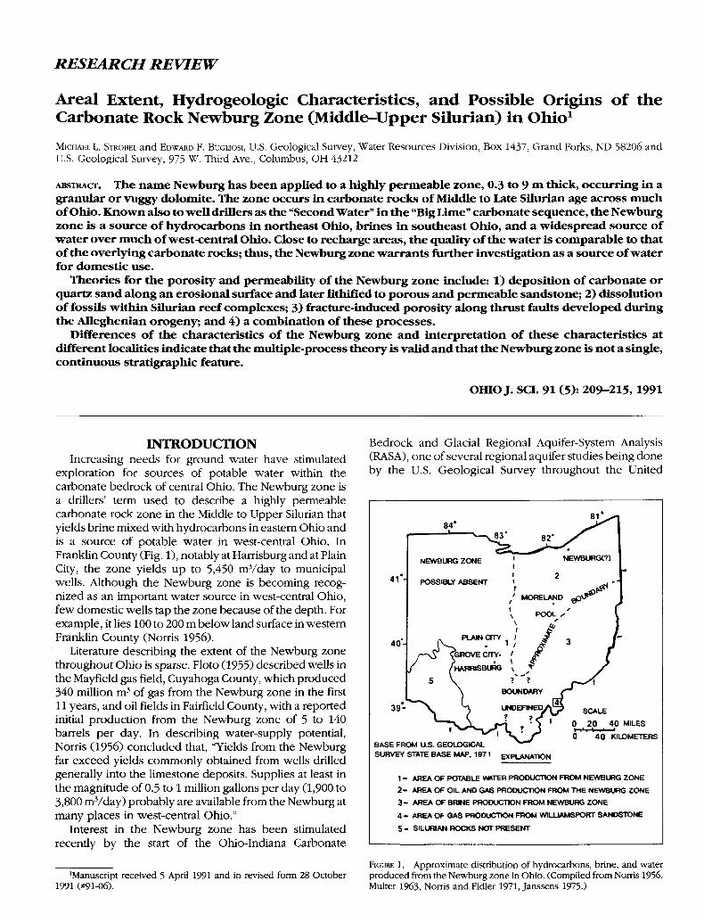
RESEARCH REVIEW Areal Extent, Hydrogeologic Characteristics, and Possible Origins of the Carbonate Rock Newburg Zone (Middle-Upper Silurian) in Ohio 1 MICHAEL L. STROBEL and EDWARD F. BUGLIOSI, U.S. Geological Survey, Water Resources Division, Box 1437, Grand Forks, ND 58206 and U.S. Geological Survey, 975 W. Third Ave., Columbus, OH 43212 ABSTRACT. The name Newburg has been applied to a highly permeable zone, 0.3 to 9 m thick, occurring in a granular or vuggy dolomite. The zone occurs in carbonate rocks of Middle to Late Silurian age across much of Ohio. Known also to well drillers as the "Second Water" in the "Big Lime" carbonate sequence, the Newburg zone is a source of hydrocarbons in northeast Ohio, brines in southeast Ohio, and a widespread source of water over much of west-central Ohio. Close to recharge areas, the quality of the water is comparable to that of the overlying carbonate rocks; thus, the Newburg zone warrants further investigation as a source of water for domestic use. Theories for the porosity and permeability of the Newburg zone include: 1) deposition of carbonate or quartz sand along an erosional surface and later lithified to porous and permeable sandstone; 2) dissolution of fossils within Silurian reef complexes; 3) fracture-induced porosity along thrust faults developed during the Alleghenian orogeny; and 4) a combination of these processes. Differences of the characteristics of the Newburg zone and interpretation of these characteristics at different localities indicate that the multiple-process theory is valid and that the Newburg zone is not a single, continuous stratigraphic feature. OHIO J. SCI. 91 (5): 209-215, 1991 INTRODUCTION Increasing needs for ground water have stimulated exploration for sources of potable water within the carbonate bedrock of central Ohio. The Newburg zone is a drillers' term used to describe a highly permeable carbonate rock zone in the Middle to Upper Silurian that yields brine mixed with hydrocarbons in eastern Ohio and is a source of potable water in west-central Ohio. In Franklin County (Fig. 1), notably at Harrisburg and at Plain City, the zone yields up to 5,450 mVday to municipal wells. Although the Newburg zone is becoming recog- nized as an important water source in west-central Ohio, few domestic wells tap the zone because of the depth. For example, it lies 100 to 200 m below land surface in western Franklin County (Norris 1956). Literature describing the extent of the Newburg zone throughout Ohio is sparse. Floto (1955) described wells in the Mayfield gas field, Cuyahoga County, which produced 340 million m 3 of gas from the Newburg zone in the first 11 years, and oil fields in Fairfield County, with a reported initial production from the Newburg zone of 5 to 140 barrels per day. In describing water-supply potential, Norris (1956) concluded that, "Yields from the Newburg far exceed yields commonly obtained from wells drilled generally into the limestone deposits. Supplies at least in the magnitude of 0.5 to 1 million gallons per day (1,900 to 3,800 mVday) probably are available from the Newburg at many places in west-central Ohio." Interest in the Newburg zone has been stimulated recently by the start of the Ohio-Indiana Carbonate Bedrock and Glacial Regional Aquifer-System Analysis (RASA), one of several regional aquifer studies being done by the U.S. Geological Survey throughout the United 84' 41- 40- 39- BASE FROM U.S. GEOLOGICAL SURVEY STATE BASE MAP. 1971 SCALE 0 20 4 0 MILES 0 40 KILOMETERS EXPLANATION 1 - AREA OF POTABLE WftTER PRODUCTION FROM NEWBURG ZONE 2- AREA OF OIL AND GAS PRODUCTION FROM THE NEWBURG ZONE 3- AREA OF BRINE PRODUCTION FROM NEWBURG ZONE 4 - AREA Of- GAS PRODUCTION FROM WILUAMSPORT SANDSTONE 5- SILURIAN ROCKS NOT PRESENT 'Manuscript received 5 April 1991 and in revised form 28 October 1991 (#91-06). FIGURE 1. Approximate distribution of hydrocarbons, brine, and water produced from the Newburg zone in Ohio. (Compiled from Norris 1956, Multer 1963, Norris and Fidler 1971, Janssens 1975.)
Transcript of Research Review: Areal Extent, Hydrogeologic ... - kb.osu.edu
RESEARCH REVIEW
Areal Extent, Hydrogeologic Characteristics, and Possible Origins of theCarbonate Rock Newburg Zone (Middle-Upper Silurian) in Ohio1
MICHAEL L. STROBEL and EDWARD F. BUGLIOSI, U.S. Geological Survey, Water Resources Division, Box 1437, Grand Forks, ND 58206 andU.S. Geological Survey, 975 W. Third Ave., Columbus, OH 43212
ABSTRACT. The name Newburg has been applied to a highly permeable zone, 0.3 to 9 m thick, occurring in agranular or vuggy dolomite. The zone occurs in carbonate rocks of Middle to Late Silurian age across muchof Ohio. Known also to well drillers as the "Second Water" in the "Big Lime" carbonate sequence, the Newburgzone is a source of hydrocarbons in northeast Ohio, brines in southeast Ohio, and a widespread source ofwater over much of west-central Ohio. Close to recharge areas, the quality of the water is comparable to thatof the overlying carbonate rocks; thus, the Newburg zone warrants further investigation as a source of waterfor domestic use.
Theories for the porosity and permeability of the Newburg zone include: 1) deposition of carbonate orquartz sand along an erosional surface and later lithified to porous and permeable sandstone; 2) dissolutionof fossils within Silurian reef complexes; 3) fracture-induced porosity along thrust faults developed duringthe Alleghenian orogeny; and 4) a combination of these processes.
Differences of the characteristics of the Newburg zone and interpretation of these characteristics atdifferent localities indicate that the multiple-process theory is valid and that the Newburg zone is not a single,continuous stratigraphic feature.
OHIO J. SCI. 91 (5): 209-215, 1991
INTRODUCTIONIncreasing needs for ground water have stimulated
exploration for sources of potable water within thecarbonate bedrock of central Ohio. The Newburg zone isa drillers' term used to describe a highly permeablecarbonate rock zone in the Middle to Upper Silurian thatyields brine mixed with hydrocarbons in eastern Ohio andis a source of potable water in west-central Ohio. InFranklin County (Fig. 1), notably at Harrisburg and at PlainCity, the zone yields up to 5,450 mVday to municipalwells. Although the Newburg zone is becoming recog-nized as an important water source in west-central Ohio,few domestic wells tap the zone because of the depth. Forexample, it lies 100 to 200 m below land surface in westernFranklin County (Norris 1956).
Literature describing the extent of the Newburg zonethroughout Ohio is sparse. Floto (1955) described wells inthe Mayfield gas field, Cuyahoga County, which produced340 million m3 of gas from the Newburg zone in the first11 years, and oil fields in Fairfield County, with a reportedinitial production from the Newburg zone of 5 to 140barrels per day. In describing water-supply potential,Norris (1956) concluded that, "Yields from the Newburgfar exceed yields commonly obtained from wells drilledgenerally into the limestone deposits. Supplies at least inthe magnitude of 0.5 to 1 million gallons per day (1,900 to3,800 mVday) probably are available from the Newburg atmany places in west-central Ohio."
Interest in the Newburg zone has been stimulatedrecently by the start of the Ohio-Indiana Carbonate
Bedrock and Glacial Regional Aquifer-System Analysis(RASA), one of several regional aquifer studies being doneby the U.S. Geological Survey throughout the United
8 4 '
4 1 -
40-
39-
BASE FROM U.S. GEOLOGICALSURVEY STATE BASE MAP. 1971
SCALE
0 2 0 40 MILES
0 40 KILOMETERS
EXPLANATION
1 - AREA OF POTABLE WftTER PRODUCTION FROM NEWBURG ZONE
2 - AREA OF OIL AND GAS PRODUCTION FROM THE NEWBURG ZONE
3 - AREA OF BRINE PRODUCTION FROM NEWBURG ZONE
4 - AREA Of- GAS PRODUCTION FROM WILUAMSPORT SANDSTONE
5 - SILURIAN ROCKS NOT PRESENT
'Manuscript received 5 April 1991 and in revised form 28 October1991 (#91-06).
FIGURE 1. Approximate distribution of hydrocarbons, brine, and waterproduced from the Newburg zone in Ohio. (Compiled from Norris 1956,Multer 1963, Norris and Fidler 1971, Janssens 1975.)
210 CARBONATE ROCK NEWBURG ZONE IN OHIO VOL. 91
States (Sun 1984). A major purpose of the RASA is todetermine the hydrogeologic characteristics of the carbon-ate aquifer system in the Silurian and Devonian rocks ineastern Indiana and western Ohio. The Newburg zone maythus play a significant regional role in the RASA carbonate-bedrock aquifer study. The purpose of writing this paper isto describe the areal extent and hydrogeologic characteris-tics of the Newburg zone compiled from available data andto present the various theories of the sedimentological ortectonic origin that have been proposed for this zone.
AREAL EXTENT AND GEOLOGICCHARACTERISTICS OF THE
NEWBURG ZONEDefinition
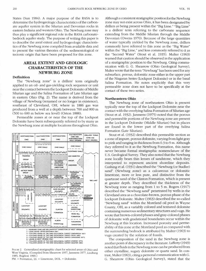
The "Newburg zone" is a drillers' term originallyapplied to an oil- and gas-yielding rock sequence or unitnear the contact between the Lockport Dolomite of MiddleSilurian age and the Salina Formation of Late Silurian agein eastern Ohio (Fig. 2). The name is derived from thevillage of Newburg (renamed or no longer in existence),southeast of Cleveland, OH, where in 1886 gas wasproduced from a well at a depth between 700 and 800 m(500 to 600 m below sea level) (Orton 1888).
Permeable zones at or near the top of the LockportDolomite have been subsequently referred to by many asthe Newburg zone at multiple locations throughout Ohio.
1 - NEWBURG SANO AND WILLIAMSPORT SANDSTONE OF WEST VIRGINIA?.- USGS USAGE-UPPER DEVONIAN ONLY
3 - FOLLOWS USAGE OF THE OH)O GEOLOGICAL SURVEY (SHEARROW 1957)4 - FOLLOWS USAGE OF THE OHO GEOLOGICAL SURVEY (DOW 1962)5 - FOLLOWS USAGE OF THE OHO GEOLOGICAL SURVEY (JANSSENS 1977)6 - USAGE IN WEST VIRGINIA ONLY7 - FOLLOWS USAGE OF THE OHIO GEOLOGICAL SURVEY (OWENS 1970)8 - FOLLOWS USAGE OF THE OHIO GEOLOGICAL SURVEY (MULTER 1963)
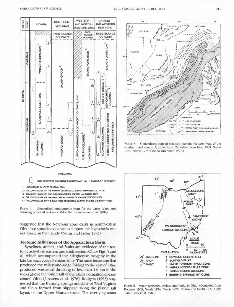
FIGURE 2. Generalized stratigraphic chart for selected areas of Ohio andWest Virginia. (Compiled from Shearrow 1957, Janssens 1977, Lindberg1985, Bugliosi 1990.)FM. = Formation, LS. = Limestone, DOL. = Dolomite.
Although a consistent stratigraphic position for the Newburgzone may not exist across Ohio, it has been designated bydrillers as being present within the "Big Lime." "Big Lime"is a drillers' term referring to the carbonate sequenceextending from the Middle Silurian through the MiddleDevonian (Owens 1970). Because of the large quantitiesof water typically yielded by the Newburg zone, drillerscommonly have referred to this zone as the "Big Water"within the "Big Lime," and less commonly referred to it asthe "Second Water" (Stout et al. 1935). Multer (1963)warned that caution should be observed in the applicationof a stratigraphic position to the Newburg. Citing commu-nication with G. G. Shearrow (Ohio Geological Survey),Multer wrote that the term "Newburg" has been used for anysubsurface, porous, dolomitic zone either in the upper partof the Niagaran Series (Lockport Dolomite) or in the basalSalina Formation. He notes explicitly that this verypermeable zone does not have to be specifically at thecontact of these two series.
Northeastern OhioThe Newburg zone of northeastern Ohio is present
typically near the top of the Lockport Dolomite near thecontact with the overlying Salina Formation of Silurian age(Stout et al. 1932). Janssens (1975) noted that the porousand permeable portions of the Newburg zone are presentin the Lockport Dolomite (Middle Silurian) but in placesare found in the lower part of the overlying SalinaFormation (Late Silurian).
Stout et al. (1932) described this permeable section asa zone of impure, porous dolomite, varying from light grayto pink and ranging in thickness from 0.3 to 9 m. Althoughthey referred to it as the Newburg Formation, this namenever became formal stratigraphic nomenclature of theU.S. Geological Survey. They also noted that the Newburgzone locally bears thin lenses of sandstone, which theyinterpreted to represent ancient shoreline deposits.Cushing et al. (1931) described the "Newburg (or Stadler)sand" (Newburg zone) as a calcareous or dolomiticlimestone, more or less pure, and distinctive from thequartzose sand of the Clinton Formation, which is presentat greater depth. They described the thickness of theNewburg zone as ranging from 1 to 5 m. Rogers (1917)described the "Newburg sand" penetrated by wells in theCleveland area as a chocolate-brown, porous phase of theLockport Dolomite. Multer (1963) described the so-called"Newburg sand" within the Moreland oil pool in WayneCounty, OH, as a variably colored and textured dolomitecontaining numerous sedimentary structures and vugs. Hewrote that brown-colored phases and gray-colored phasesof dolomite with gradational boundaries occur within theNewburg at this location. Increased porosity and perme-ability of this zone at the Moreland pool as compared withthe surrounding bedrock is attributed by Multer (1963) tovugs created by the solution of fossils.
The composition of the sand in the Newburg zone isanother point of discrepancy in the literature. Lafferty (1949)noted that fluids in the Newburg zone can be produced fromeither crystalline, sugary dolomite or quartz sand. In con-trast, Multer (1963), citing a personal communication with G.G. Shearrow (Ohio Geological Survey), stated that the
OHIO JOURNAL OF SCIENCE M. L. STROBEL AND E. F. BUGLIOSI 211
Newburg zone in Ohio is present only in a porous, sugarydolomite and does not contain beds of quartz sand, althoughsome secondary quartz may line the dolomite vugs. InMulter's (1963) description of the "Newburg sand," he didnot observe any evidence of beds of quartz sandstone in theNewburg zone at the Moreland pool.
Bownocker (1910) wrote that wells drilled in RichlandCounty penetrate the oil- and gas-bearing "sand" usuallyabout 195 m below the top of the "Big Lime." However,depths of the "sand" ranging from 119 to 152 m below thetop of the Big Lime have been reported for the county.
Southeastern OhioJanssens (1975) included the Williamsport Sandstone in
his description of the Newburg zone. The WilliamsportSandstone is a quartz sandstone occurring mainly in WestVirginia but extending into Meigs County, OH. Janssensreferenced drillers' logs in applying the term "Newburg"to this high-porosity zone in West Virginia, but strati-graphic or lithologic correlation to the Newburg zone ofcentral and northeastern Ohio has not been determined.Patchen (1967) explained that the use of the term "Newburgsand" is common in West Virginia drilling terminology todenote the Williamsport Sandstone, hence the use of"Newburg" for this unit in southeastern Ohio. Janssens(1975) analyzed the Newburg zone on a regional scale anddefined the zone on the basis of yield, not on stratigraphicoccurrence. Collins and Smith (1977), however, wrote thatminor amounts of sand deposits have been found at thetop of the Lockport Dolomite in Washington County, OH.Woodward (1959) identified this as the WilliamsportSandstone, corresponding with the Group C unit of theSalina Formation of Ohio (Janssens 1975).
Western OhioIn western Ohio, Norris and Fidler (1973) place the
Newburg zone in the lower part of the Bass Islands Group(Late Silurian). They stated that wells penetrating thispermeable stratum in west-central and western Ohioprovide evidence that the Newburg zone occurs at aspecific position in the stratigraphic column. Althoughevidence for the existence of the Newburg zone innorthwestern Ohio was not established by Norris andFidler (1971), field data strongly indicate that a highlypermeable zone is present in western Ohio and is correla-tive and probably continuous with the Newburg zone ofeastern Ohio (Norris and Fidler 1973).
WATER QUALITY IN THE NEWBURG ZONEThe water quality in the Newburg changes from
potable to brine along a traverse line from west to eastacross Ohio. Recharge to the Silurian-age bedrockaquifers occurs in the western part of the state where theseunits outcrop or subcrop. Although some local dischargeoccurs in areas where the overlying shale confining unitsare thin or missing, the majority of the ground water flowsdown-gradient to the east. The major change in waterquality occurs along this flowpath.
In western Ohio, the quality of water in the Newburgzone is comparable to that of water in the overlyingcarbonate rocks, which changes from a calcium bicar-
bonate type in areas of recharge to a calcium sulfate typein local areas of natural discharge (Norris and Fidler 1973).
The quality of the water sampled from the Newburgzone east of western Franklin County, OH, is compara-tively poor in comparison to other ground-water sourcesin the area. Water-quality data are listed for the Newburgzone in central Ohio; as indicated, water from this zone isvery hard and commonly contains elevated concentra-tions of dissolved solids (Table 1).
TABLE 1
Analyses of water from the "Newburg sand" (drillers' term) atHarrisburg, Plain City, and Grove City.
Properties andconstituents
Specific conductance(microsiemens percentimeter at 25° C)
pHColor, unitsHydrogen sulfideHardness as CaCO3:
Calcium and magnesiumNoncarbonateTotal hardness
CalciumMagnesiumSodiumPotassiumBicarbonateCarbonateSulfateChlorideFluorideSilicaDissolved solids (residue
on evaporation at 180° C)NitrateIronManganese
Harrisburg(2-16-55)
1,0507.45
.1
5322137451344835
3.4389
0239
232.1
15
720.2.37.00
Plain City(2-15-55)
1,0407.25
.5
57322679914352193.5
4200
235121.7
11
724.2.75.00
Grove City(10-23-54)
2,4607.033.6
1,5701,3102,880
42412451
5.8316
01,220
842.3
10
2,230.4.36.00
All values in parts per million unless noted otherwise.(From Norris 1956)
In eastern Ohio, the Newburg zone yields a widelydistributed brine (Stout et al. 1932). Production andmanufacturing of salt from the Newburg brine was com-mon during the 1800s throughout most of eastern Ohioand as far west as Jackson, Licking, and Morrow counties(Stout et al. 1932). There are no references to the Newburgas a source of potable water in eastern Ohio.
POSSIBLE ORIGINS OF THE POROSITYAND PERMEABILITY OF
THE NEWBURG ZONEThe relatively high permeability and porosity of the
Newburg zone has been attributed to: 1) deposition ofsands, later lithified into porous and permeable sandstonealong an erosional surface near the top of the LockportDolomite in eastern Ohio; 2) geochemical dissolution ofdolomitized fossils within Silurian reef complexes, whichhas created vugs in the rocks in western and northernOhio; and 3) solution of the Silurian carbonates along
212 CARBONATE ROCK NEWBURG ZONE IN OHIO VOL. 91
faults and fractures in southeastern Ohio, which resultedfrom tectonic activity associated with the Acadian andAlleghenian orogenies.
Sediment Deposition on an Erosional SurfaceThe theory of sediment deposition on an erosional
surface was first postulated by Stout et al. (1932). Theydescribed the Newburg zone as a unit containing thinlenses of sandstone that represent original shorelinedeposits of sand left along a surface of disconformity. Stoutet al. (1935), Lafferty (1949), and Collins and Smith (1977),among others, discussed the presence of sandstone alongthis surface, although there is some disagreement over thecomposition of the sandstone.
The contact between the Lockport Dolomite and theoverlying Salina Formation marks the position of theNewburg zone in some localities; but, in general, theposition of the Newburg zone is not stratigraphically fixed.The presence of the Newburg zone throughout much ofthe upper Lockport Dolomite in northeastern Ohio, thelower part of the Salina Formation in southeastern Ohio,and the lower Bass Islands Group in western Ohio (Fig. 2)may indicate a widespread erosional event over theregion; however, the sporadic occurrence and variablestratigraphic position of the Newburg zone suggests thatthe Newburg zone represents several erosional surfacesthat do not relate to the same erosional event. Drilling dataindicate that the Newburg zone is present within theLockport Dolomite at some places and stratigraphicallyabove it nearby. This supports the theory of an origin frommultiple discontinuous erosional surfaces rather than asingle, continuous surface. Because the carbonate units thatconstitute the "Big Lime" are relatively continuous verticallyand may be hydraulically connected in parts of Ohio, thevarious permeable zones would function as a single unit.Detailed mapping based on drilling logs, drill cuttings, andgeophysical logs would be required to improve an under-standing of the continuity of the Newburg zone.
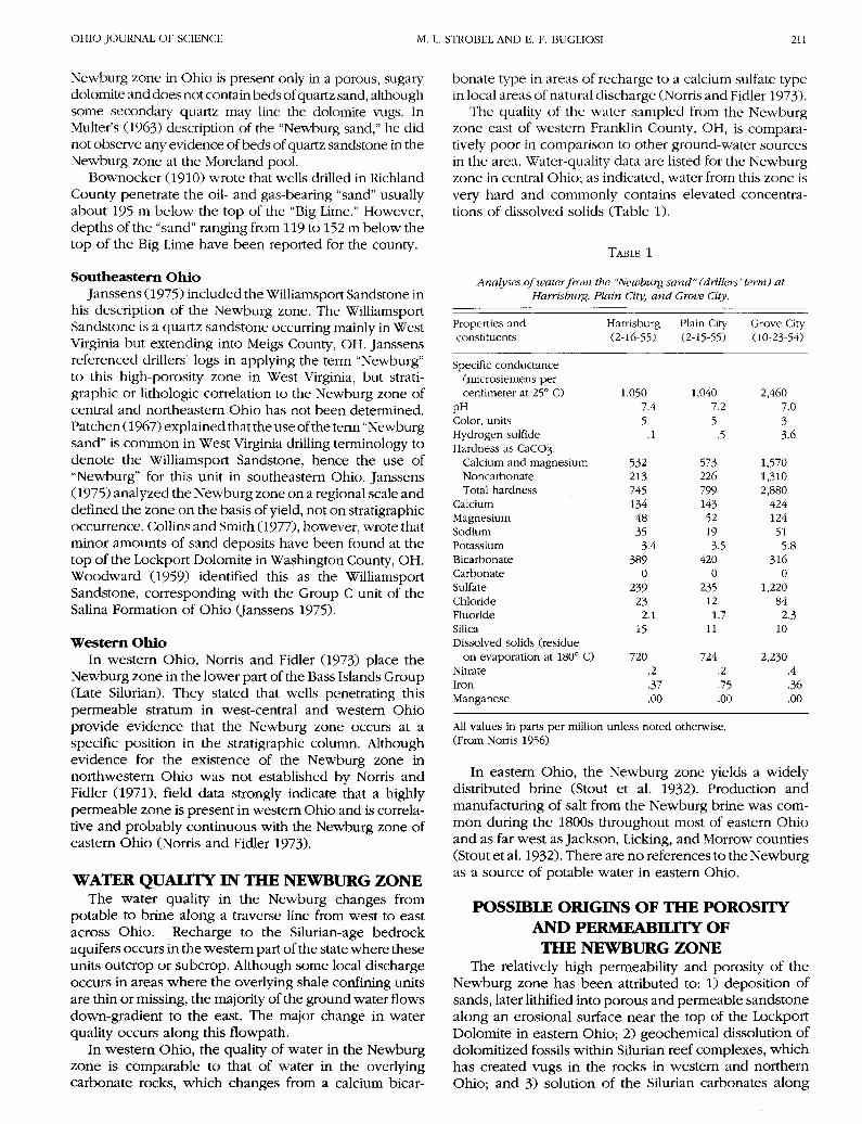
Dissolution of Fossils in Reef ComplexesFloto (1955) wrote that the Newburg zone has certain
structural and depositional characteristics associated withNiagaran-age reefs. These include relatively sharp closureof the structural contours, variations in the stratigraphicelevation of the Newburg zone caused by differentialcompaction on the reef complex, and local thickening ofthe Newburg zone at oil fields and gas fields; however,cuttings examined by Floto from two producing fields innortheastern Ohio offer no evidence of reef origin. Flotoattributed this lack of evidence to erosional, biological,and diagenetic processes that erased organic structuresand produced a dense, massive carbonate rock unit. Flotobased much of his argument for the presence of theNewburg zone on the development of rocks formed fromsediments deposited along the postulated position of theancient shoreline of the Niagaran sea and the documentedoccurrence of reef complexes in this environment (Fig. 3).
Porosity and permeability within the Newburg zonehave been attributed to the composition and fabric ofancient reef complexes at this stratigraphic level.Stromatoporoid structures at the top of the Newburg zone
41°-
4 0 -
39° -
EXPLANAT1ON KILOMETERS
REEF
CARBONATE BANK ORBARRIER REEF
FIGURE 3. Selected reefs and carbonate banks or barrier reefs in Silurianrocks of Ohio. (Modified from Shaver et al. 1978.)
at the Moreland oil pool, Wayne County, OH, are welldocumented by Multer (1963). According to Multer, physi-cal evidence, such as fossils of reef-forming organisms(brachiopods, gastropods, stromatoporoids, and corals),and structural evidence, such as slumping and slidingbeing confined to the immediately overlying gray dolo-mite, indicates the possibility of a reef origin. Multersuggested that the porosity and permeability of theNewburg zone appear to be related to: 1) solution byground water that dissolved fossils and left a vuggytexture; 2) open fractures; 3) stylolites; and 4) secondarymineralization within the vugs.
The variations in the stratigraphic position of theNewburg zone may be associated with the occurrence ofreef complexes. Reef cyclicity—the occurrence of succes-sive reef generations in a certain area (Shaver andSunderman 1989)—is characteristic of the Silurian sequencein Ohio rocks of the Appalachian Basin as it is for Silurianrocks of the Illinois and Michigan Basins (Fig. 4). Cyclesof reef growth can result in differences in the verticalstratigraphic position of the Newburg zone. Likewise,differential compaction of sediments on and around reefscould have resulted in stratigraphic and regionaldiscontinuities in the presence of permeable zones.
Close examination of these data suggests that thehypothesis that the high permeability of the Newburgzone results from the presence of reefs is inconsistentacross the state. In northwestern Ohio, where reef struc-tures in the Silurian rocks are well documented in out-crops, quarries, and cores, the Newburg zone is notpresent. In their ground-water study of northwestern Ohio,Norris and Fidler (1971) found high-yielding bedrock wellsin structurally high areas associated with ancient reefs;however, they did not find a specific water-yielding zonecorrelative to the Newburg zone in central Ohio. They
OHIO JOURNAL OF SCIENCE M. L. STROBEL AND E. F. BUGLIOSI 213
INDIANASOUTHERN
MICHIGAN
BASS ISLANDSDOLOMITE
WESTERNAND NORTH -
WESTERN OHIO
I .—
ONTARIOAND WESTERN
NEW YORK
BASS ISLANDSDOLOMITE
XPLANATION
AXIS OF ANTICLINE
AXIS OF SYNCLINE
NORMAL FAULT—ticks indicate dip direction
THRUST FAULT—teeth on upper plate
FIGURE 5. Generalized map of selected tectonic features west of thesouthern and central Appalachians. (Modified from King 1969, Norris1974, Norris 1975, Collins and Smith 1977.)
EXPLANATION
j | REEF GROWTHS. NUMBERED SEQUENTIALLY ( i.e. 1 = OLDEST. 6 = YOUNGEST )
1 - USGS USAGE IN UPPER SILURIAN ONLY
2.- FOLLOWS USAGE OF THE INDIANA GEOLOGICAL SURVEY (SHAVER ET AL. 1978)
3.- FOLLOWS USAGE OF THE OHIO GEOLOGICAL SURVEY (JANSSENS 1977)
4.- FOLLOWS USAGE OF THE GEOLOGICAL SURVEY OF CANADA (BOLTON 1957)
5 - FOLLOWS USAGE OF THE NEW YORK GEOLOGICAL SURVEY (FISHER AND BRETT 1981)
FIGURE 4. Generalized stratigraphic chart for the Great Lakes areashowing principal reef rock. (Modified from Shaver et al. 1978.)
suggested that the Newburg zone exists in northwesternOhio, but specific evidence to support this hypothesis wasnot found in their study (Norris and Fidler 1973).
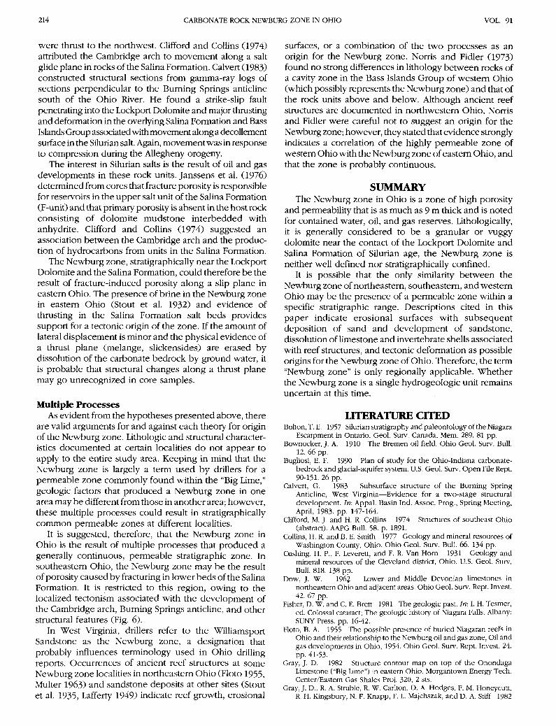
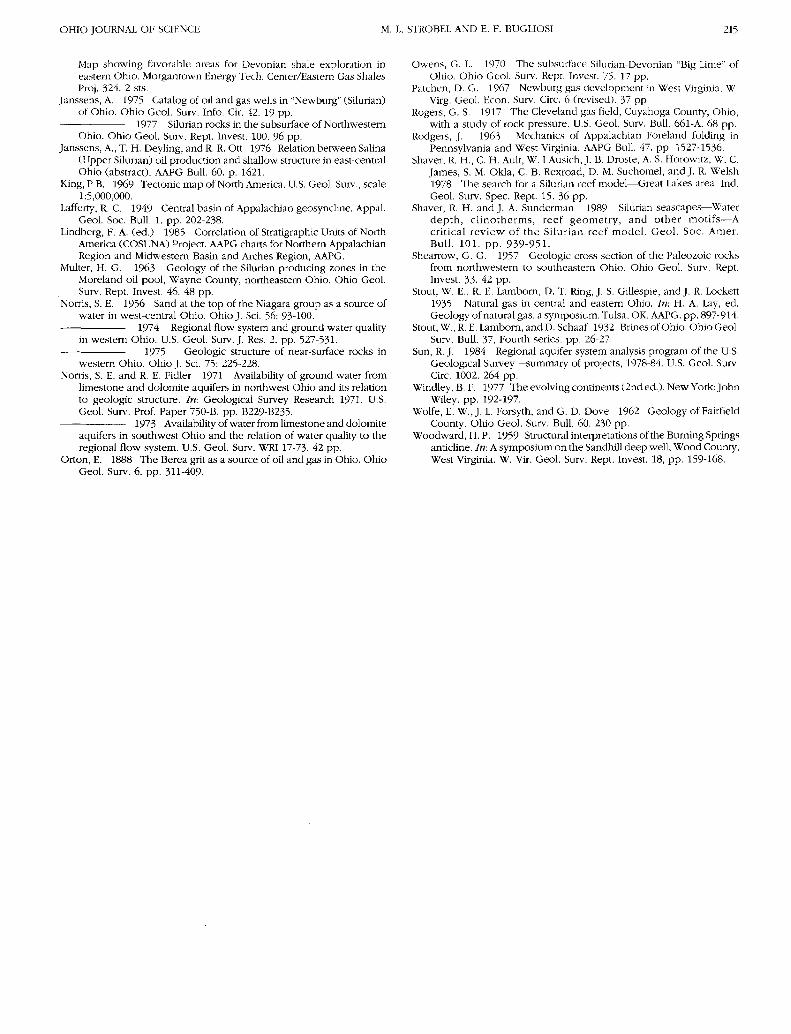
Tectonic Influences of the Appalachian BasinSynclines, arches, and faults are evidence of the tec-
tonic activity in eastern and southeastern Ohio (Figs. 5 and6), which accompanied the Alleghenian orogeny in thelate Carboniferous-Permian time. The same tectonism thatproduced the valley-and-ridge folding to the east of Ohioproduced westward thrusting of less than 1.6 km in therocks above the E-unit salt of the Salina Formation in east-central Ohio (Janssens et al. 1976). Rodgers (1963) sug-gested that the Burning Springs anticline of West Virginiaand Ohio formed from slippage along the plastic saltlayers of the Upper Silurian rocks. The overlying strata
4 1 " -
4 0 ° - CAMBRIDGEARCH j
50
EXPLANATION0 50 100
KILOMETERS
SYNCLINE 1 BOWLING GREEN FAULTARCH 2 SUFRELD FAULTFAULT 3 SMITH TOWNSHIP FAULT ZONE
4 NGHLANDTOWN FAULT ZONE5 PARKERSBURG SYNCLINE6 BURNING SPRINGS ANTICLINE
FIGURE 6. Major synclines, arches, and faults in Ohio. (Compiled fromRodgers 1963, Norris 1974, Norris 1975, Collins and Smith 1977, Gray1982, Gray et al. 1982.)
214 CARBONATE ROCK NEWBURG ZONE IN OHIO VOL. 91
were thrust to the northwest. Clifford and Collins (1974)attributed the Cambridge arch to movement along a saltglide plane in rocks of the Salina Formation. Calvert (1983)constructed structural sections from gamma-ray logs ofsections perpendicular to the Burning Springs anticlinesouth of the Ohio River. He found a strike-slip faultpenetrating into the Lockport Dolomite and major thrustingand deformation in the overlying Salina Formation and BassIslands Group associated with movement along a decollementsurface in the Silurian salt. Again, movement was in responseto compression during the Allegheny orogeny.
The interest in Silurian salts is the result of oil and gasdevelopments in these rock units. Janssens et al. (1976)determined from cores that fracture porosity is responsiblefor reservoirs in the upper salt unit of the Salina Formation(F-unit) and that primary porosity is absent in the host rockconsisting of dolomite mudstone interbedded withanhydrite. Clifford and Collins (1974) suggested anassociation between the Cambridge arch and the produc-tion of hydrocarbons from units in the Salina Formation.
The Newburg zone, stratigraphically near the LockportDolomite and the Salina Formation, could therefore be theresult of fracture-induced porosity along a slip plane ineastern Ohio. The presence of brine in the Newburg zonein eastern Ohio (Stout et al. 1932) and evidence ofthrusting in the Salina Formation salt beds providessupport for a tectonic origin of the zone. If the amount oflateral displacement is minor and the physical evidence ofa thrust plane (melange, slickensides) are erased bydissolution of the carbonate bedrock by ground water, itis probable that structural changes along a thrust planemay go unrecognized in core samples.
Multiple ProcessesAs evident from the hypotheses presented above, there
are valid arguments for and against each theory for originof the Newburg zone. Lithologic and structural character-istics documented at certain localities do not appear toapply to the entire study area. Keeping in mind that theNewburg zone is largely a term used by drillers for apermeable zone commonly found within the "Big Lime,"geologic factors that produced a Newburg zone in onearea may be different from those in another area; however,these multiple processes could result in stratigraphicallycommon permeable zones at different localities.
It is suggested, therefore, that the Newburg zone inOhio is the result of multiple processes that produced agenerally continuous, permeable stratigraphic zone. Insoutheastern Ohio, the Newburg zone may be the resultof porosity caused by fracturing in lower beds of the SalinaFormation. It is restricted to this region, owing to thelocalized tectonism associated with the development ofthe Cambridge arch, Burning Springs anticline, and otherstructural features (Fig. 6).
In West Virginia, drillers refer to the WilliamsportSandstone as the Newburg zone, a designation thatprobably influences terminology used in Ohio drillingreports. Occurrences of ancient reef structures at someNewburg zone localities in northeastern Ohio (Floto 1955,Multer 1963) and sandstone deposits at other sites (Stoutet al. 1935, Lafferty 1949) indicate reef growth, erosional
surfaces, or a combination of the two processes as anorigin for the Newburg zone. Norris and Fidler (1973)found no strong differences in lithology between rocks ofa cavity zone in the Bass Islands Group of western Ohio(which possibly represents the Newburg zone) and that ofthe rock units above and below. Although ancient reefstructures are documented in northwestern Ohio, Norrisand Fidler were careful not to suggest an origin for theNewburg zone; however, they stated that evidence stronglyindicates a correlation of the highly permeable zone ofwestern Ohio with the Newburg zone of eastern Ohio, andthat the zone is probably continuous.
SUMMARYThe Newburg zone in Ohio is a zone of high porosity
and permeability that is as much as 9 m thick and is notedfor contained water, oil, and gas reserves. Lithologically,it is generally considered to be a granular or vuggydolomite near the contact of the Lockport Dolomite andSalina Formation of Silurian age, the Newburg zone isneither well defined nor stratigraphically confined.
It is possible that the only similarity between theNewburg zone of northeastern, southeastern, and westernOhio may be the presence of a permeable zone within aspecific stratigraphic range. Descriptions cited in thispaper indicate erosional surfaces with subsequentdeposition of sand and development of sandstone,dissolution of limestone and invertebrate shells associatedwith reef structures, and tectonic deformation as possibleorigins for the Newburg zone of Ohio. Therefore, the term"Newburg zone" is only regionally applicable. Whetherthe Newburg zone is a single hydrogeologic unit remainsuncertain at this time.
LITERATURE CITEDBolton, T. E. 1957 Silurian stratigraphy and paleontology of the Niagara
Escarpment in Ontario. Geol. Surv. Canada, Mem. 289. 81 pp.Bownocker, J. A. 1910 The Bremen oil field. Ohio Geol. Surv. Bull.
12. 66 pp.Bugliosi, E. F. 1990 Plan of study for the Ohio-Indiana carbonate-
bedrock and glacial-aquifer system. U.S. Geol. Surv. Open File Rept.90-151. 26 pp.
Calvert, G. 1983 Subsurface structure of the Burning SpringAnticline, West Virginia—Evidence for a two-stage structuraldevelopment. In: Appal. Basin Ind. Assoc. Prog., Spring Meeting,April, 1983. pp. 147-164.
Clifford, M. J. and H. R. Collins 1974 Structures of southeast Ohio(abstract). AAPG Bull. 58. p. 1891.
Collins, H. R. and B. E. Smith 1977 Geology and mineral resources ofWashington County, Ohio. Ohio Geol. Surv. Bull. 66. 134 pp.
Cushing, H. P., F. Leverett, and F. R. Van Horn 1931 Geology andmineral resources of the Cleveland district, Ohio. U.S. Geol. Surv.Bull. 818. 138 pp.
Dow, J. W. 1962 Lower and Middle Devonian limestones innortheastern Ohio and adjacent areas. Ohio Geol. Surv. Rept. Invest.42. 67 pp.
Fisher, D. W. and C. E. Brett 1981 The geologic past. In: I. H. Tesmer,ed. Colossal cataract; The geologic history of Niagara Falls. Albany:SUNY Press, pp. 16-42.
Floto, B. A. 1955 The possible presence of buried Niagaran reefs inOhio and their relationship to the Newburg oil and gas zone, Oil andgas developments in Ohio, 1954. Ohio Geol. Surv. Rept. Invest. 24.pp. 41-53.
Gray, J. D. 1982 Structure contour map on top of the OnondagaLimestone ("Big Lime") in eastern Ohio. Morgantown Energy Tech.Center/Eastern Gas Shales Proj. 320, 2 sts.
Gray, J. D., R. A. Struble, R. W. Carlton, D. A. Hodges, F. M. Honeycutt,R. H. Kingsbury, N. F. Knapp, F. L. Majchszak, and D. A. Stiff 1982
OHIO JOURNAL OF SCIENCE M. L. STROBEL AND E. F. BUGLIOSI 215
Map showing favorable areas for Devonian shale exploration ineastern Ohio. Morgantown Energy Tech. Center/Eastern Gas ShalesProj. 324. 2 sts.
Janssens, A. 1975 Catalog of oil and gas wells in "Newburg" (Silurian)of Ohio. Ohio Geol. Surv. Info. Cir. 42. 19 pp.
1977 Silurian rocks in the subsurface of NorthwesternOhio. Ohio Geol. Surv. Rept. Invest. 100. % pp.
Janssens, A., T. H. Deyling, and R. R. Ott 1976 Relation between Salina(Upper Silurian) oil production and shallow structure in east-centralOhio (abstract). AAPG Bull. 60. p. 1621.
King, PB. 1969 Tectonic map of North America. U.S. Geol. Surv., scale1:5,000,000.
Lafferty, R. C. 1949 Central basin of Appalachian geosyncline. Appal.Geol. Soc. Bull. 1. pp. 202-238.
Lindberg, F. A. (ed.) 1985 Correlation of Stratigraphic Units of NorthAmerica (COSUNA) Project. AAPG charts for Northern AppalachianRegion and Midwestern Basin and Arches Region, AAPG.
Multer, H. G. 1963 Geology of the Silurian producing zones in theMoreland oil pool, Wayne County, northeastern Ohio. Ohio Geol.Surv. Rept. Invest. 46. 48 pp.
Norris, S. E. 1956 Sand at the top of the Niagara group as a source ofwater in west-central Ohio. Ohio J. Sci. 56: 93-100.
1974 Regional flow system and ground water qualityin western Ohio. U.S. Geol. Surv. J. Res. 2. pp. 527-531.
1975 Geologic structure of near-surface rocks inwestern Ohio. Ohio J. Sci. 75: 225-228.
Norris, S. E. and R. E. Fidler 1971 Availability of ground water fromlimestone and dolomite aquifers in northwest Ohio and its relationto geologic structure. In: Geological Survey Research 1971. U.S.Geol. Surv. Prof. Paper 750-B. pp. B229-B235.
1973 Availability of water from limestone and dolomiteaquifers in southwest Ohio and the relation of water quality to theregional flow system. U.S. Geol. Surv. WRI 17-73- 42 pp.
Orton, E. 1888 The Berea grit as a source of oil and gas in Ohio. OhioGeol. Surv. 6. pp. 311-409.
Owens, G. L. 1970 The subsurface Silurian-Devonian "Big Lime" ofOhio. Ohio Geol. Surv. Rept. Invest. 75. 17 pp.
Patchen, D. G. 1967 Newburg gas development in West Virginia. W.Virg. Geol. Econ. Surv. Circ. 6 (revised). 37 pp.
Rogers, G. S. 1917 The Cleveland gas field, Cuyahoga County, Ohio,with a study of rock pressure. U.S. Geol. Surv. Bull. 661-A. 68 pp.
Rodgers, J. 1963 Mechanics of Appalachian Foreland folding inPennsylvania and West Virginia. AAPG Bull. 47. pp. 1527-1536.
Shaver, R. H., C. H. Ault, W. I Ausich, J. B. Droste, A. S. Horowitz, W. C.James, S. M. Okla, C. B. Rexroad, D. M. Suchomel, andj . R. Welsh1978 The search for a Silurian reef model—Great Lakes area. Ind.Geol. Surv. Spec. Rept. 15. 36 pp.
Shaver, R. H. and J. A. Sunderman 1989 Silurian seascapes—Waterdepth, cl inotherms, reef geometry, and other motifs—Acritical review of the Silurian reef model. Geol. Soc. Amer.Bull. 101. pp. 939-951.
Shearrow, G. G. 1957 Geologic cross section of the Paleozoic rocksfrom northwestern to southeastern Ohio. Ohio Geol. Surv. Rept.Invest. 33- 42 pp.
Stout, W. E., R. E. Lamborn, D. T. Ring, J. S. Gillespie, and J. R. Lockett1935 Natural gas in central and eastern Ohio. In: H. A. Lay, ed.Geology of natural gas, a symposium. Tulsa, OK, AAPG. pp. 897-914.
Stout, W.,R.E. Lamborn, and D.Schaaf 1932 Brines of Ohio. Ohio Geol.Surv. Bull. 37, Fourth series, pp. 26-27.
Sun, R. J. 1984 Regional aquifer-system analysis program of the U.S.Geological Survey—summary of projects, 1978-84. U.S. Geol. Surv.Circ. 1002. 264 pp.
Windley, B. F. 1977 The evolving continents (2nd ed.). New York: JohnWiley, pp. 192-197.
Wolfe, E. W., J. L. Forsyth, and G. D. Dove 1962 Geology of FairfieldCounty. Ohio Geol. Surv. Bull. 60. 230 pp.
Woodward, H. P. 1959 Structural interpretations of the Burning Springsanticline. In. A symposium on the Sandhill deep well, Wood County,West Virginia. W. Vir. Geol. Surv. Rept. Invest. 18, pp. 159-168.