Research Article The Edgerton Structure: A Possible - downloads
7
Hindawi Publishing Corporation International Journal of Geophysics Volume 2009, Article ID 621528, 6 pages doi:10.1155/2009/621528 Research Article The Edgerton Structure: A Possible Meteorite Impact Feature in Eastern Kansas Daniel F. Merriam, 1 Jianghai Xia, 2 and John W. Harbaugh 3 1 Univesity of Kansas, 1930 Constant Avenue, West Campus, Lawrence, KS 66047, USA 2 Kansas Geological Survey, University of Kansas, Lawrence, KS 66047, USA 3 Department of Geological and Environmental Sciences, Stanford University, Stanford, CA 94305, USA Correspondence should be addressed to Daniel F. Merriam, [email protected] Received 18 March 2009; Accepted 18 October 2009 Recommended by Marek Grad Recognized meteorite impact features are relatively rare in the U.S. Midcontinent region, but recently with increased interest and research, the number has increased dramatically. We add another possibility to the growing list, the Edgerton structure in northwestern Miami County, Kansas. The feature is elliptical (∼5.5 × 6.5 km, slightly elongated east-west) with radial surface drainage. The feature was first observed on hillshade maps of digitized topography of 7.5 minute quadrangles. Subsequent magnetic profiles show a higher magnetic value in the center of the ellipse with higher values around the edges; this shape is characteristic of an impact feature. Depth to the anomalous body is estimated to be about 1 km, which puts it in the Precambrian crystalline basement under a cover of Paleozoic sediments. There are no deep boreholes in the vicinity and no seismic profiles are available. If it is an impact structure, it will be the second such feature documented in Kansas, the first being the Brenham meteorite crater at Haviland in Kiowa County in southwestern Kansas. It would be older than the other impact structures identified in the Midcontinent—Manson in Iowa, Ames in Oklahoma, Haswell Hole in Colorado, and possibly Belton in Missouri and Merna in Nebraska. There are at least two other prospective impact features in Kansas: the Goddard ring west of Wichita and Garden City ellipse north-west of Garden City. Copyright © 2009 Daniel F. Merriam et al. This is an open access article distributed under the Creative Commons Attribution License, which permits unrestricted use, distribution, and reproduction in any medium, provided the original work is properly cited. 1. Introduction Circular, oval, or elliptical features, observed on airphotos, remote-sensed images, topographic quadrangle maps, hill- shade maps, or on the ground in the field, may be the result of several independent or combination of factors. The most obvious and spectacular features are sinkholes that form relatively quickly and “buffalo wallows,” shallow depressions present in large numbers on the High Plains. More recently, some circular features have been attributed to meteorite impact. There are at least five causes of physiographic circular features: (1) erosion widens a valley and then closes the open end giving an illusion of a circular feature, for example, Cheyenne Bottoms in Barton County, (2) solution of material and collapse of overlying mate- rial to form a sinkhole, for example, Old Maids Pool in Wallace County, (3) meteorite impact feature, for example, Haviland crater (the term crater is used here in the sense of a meteorite impact feature and does not necessarily imply a surface depression) in Kiowa County, (4) buffalo wallows—formed by animals and enlarged by wind, with many examples on the High Plains [1], (5) dish-shaped structure with compaction of overlying sediments. We are interested here only in the meteorite impact features. There have been speculations for years of possible meteorite impact features in Kansas. In fact, Big Basin and
Transcript of Research Article The Edgerton Structure: A Possible - downloads

Hindawi Publishing CorporationInternational Journal of GeophysicsVolume 2009, Article ID 621528, 6 pagesdoi:10.1155/2009/621528
Research Article
The Edgerton Structure: A Possible Meteorite Impact Feature inEastern Kansas
Daniel F. Merriam,1 Jianghai Xia,2 and John W. Harbaugh3
1 Univesity of Kansas, 1930 Constant Avenue, West Campus, Lawrence, KS 66047, USA2 Kansas Geological Survey, University of Kansas, Lawrence, KS 66047, USA3 Department of Geological and Environmental Sciences, Stanford University, Stanford, CA 94305, USA
Correspondence should be addressed to Daniel F. Merriam, [email protected]
Received 18 March 2009; Accepted 18 October 2009
Recommended by Marek Grad
Recognized meteorite impact features are relatively rare in the U.S. Midcontinent region, but recently with increased interestand research, the number has increased dramatically. We add another possibility to the growing list, the Edgerton structure innorthwestern Miami County, Kansas. The feature is elliptical (∼5.5 × 6.5 km, slightly elongated east-west) with radial surfacedrainage. The feature was first observed on hillshade maps of digitized topography of 7.5 minute quadrangles. Subsequentmagnetic profiles show a higher magnetic value in the center of the ellipse with higher values around the edges; this shape ischaracteristic of an impact feature. Depth to the anomalous body is estimated to be about 1 km, which puts it in the Precambriancrystalline basement under a cover of Paleozoic sediments. There are no deep boreholes in the vicinity and no seismic profiles areavailable. If it is an impact structure, it will be the second such feature documented in Kansas, the first being the Brenham meteoritecrater at Haviland in Kiowa County in southwestern Kansas. It would be older than the other impact structures identified in theMidcontinent—Manson in Iowa, Ames in Oklahoma, Haswell Hole in Colorado, and possibly Belton in Missouri and Merna inNebraska. There are at least two other prospective impact features in Kansas: the Goddard ring west of Wichita and Garden Cityellipse north-west of Garden City.
Copyright © 2009 Daniel F. Merriam et al. This is an open access article distributed under the Creative Commons AttributionLicense, which permits unrestricted use, distribution, and reproduction in any medium, provided the original work is properlycited.
1. Introduction
Circular, oval, or elliptical features, observed on airphotos,remote-sensed images, topographic quadrangle maps, hill-shade maps, or on the ground in the field, may be the resultof several independent or combination of factors. The mostobvious and spectacular features are sinkholes that formrelatively quickly and “buffalo wallows,” shallow depressionspresent in large numbers on the High Plains. More recently,some circular features have been attributed to meteoriteimpact.
There are at least five causes of physiographic circularfeatures:
(1) erosion widens a valley and then closes the open endgiving an illusion of a circular feature, for example,Cheyenne Bottoms in Barton County,
(2) solution of material and collapse of overlying mate-rial to form a sinkhole, for example, Old Maids Poolin Wallace County,
(3) meteorite impact feature, for example, Havilandcrater (the term crater is used here in the sense ofa meteorite impact feature and does not necessarilyimply a surface depression) in Kiowa County,
(4) buffalo wallows—formed by animals and enlarged bywind, with many examples on the High Plains [1],
(5) dish-shaped structure with compaction of overlyingsediments.
We are interested here only in the meteorite impactfeatures.
There have been speculations for years of possiblemeteorite impact features in Kansas. In fact, Big Basin and
2 International Journal of Geophysics
(km)
(mi)
N
Hays
DodgeCity
Salina
Emporia
Wichita
Location of recorded meteorites
Haviland meteorite crater
Anthony
Zenith
CullisonBrenhamMullinville
Burdett
Otis
Ness County
Ness County
Galatia
Covert
Waconda
GretnaLong Island
Phillips CountyNorton
Densmore
AlmetoTownship
Morland
St PeterSaline
Selden
Dresden
OberlinBeardsley
Goodland
Oakley
Jerome
Modoc
Kalvesta
Pierceville
Ulysses
Hugoton
Rolla
Richfield
Ladder Creek
RussellSprings
TribuneHorace 1
Horace 2
Kasada
Achilles
Beeler
CastlesBros. Farm
Ransom
Belleville Washington
Farmington
Seneca Wathena
Mays
Ellis County
Yocemento
Coldwater
Becky’sKnob
Whitewater
Admire
Elm Creek
Ottawa
EdgertonLawrence
(KU)
Hesston
Inman
Belle Plaine III
Tonganoxie
0 60 120
0 60 80
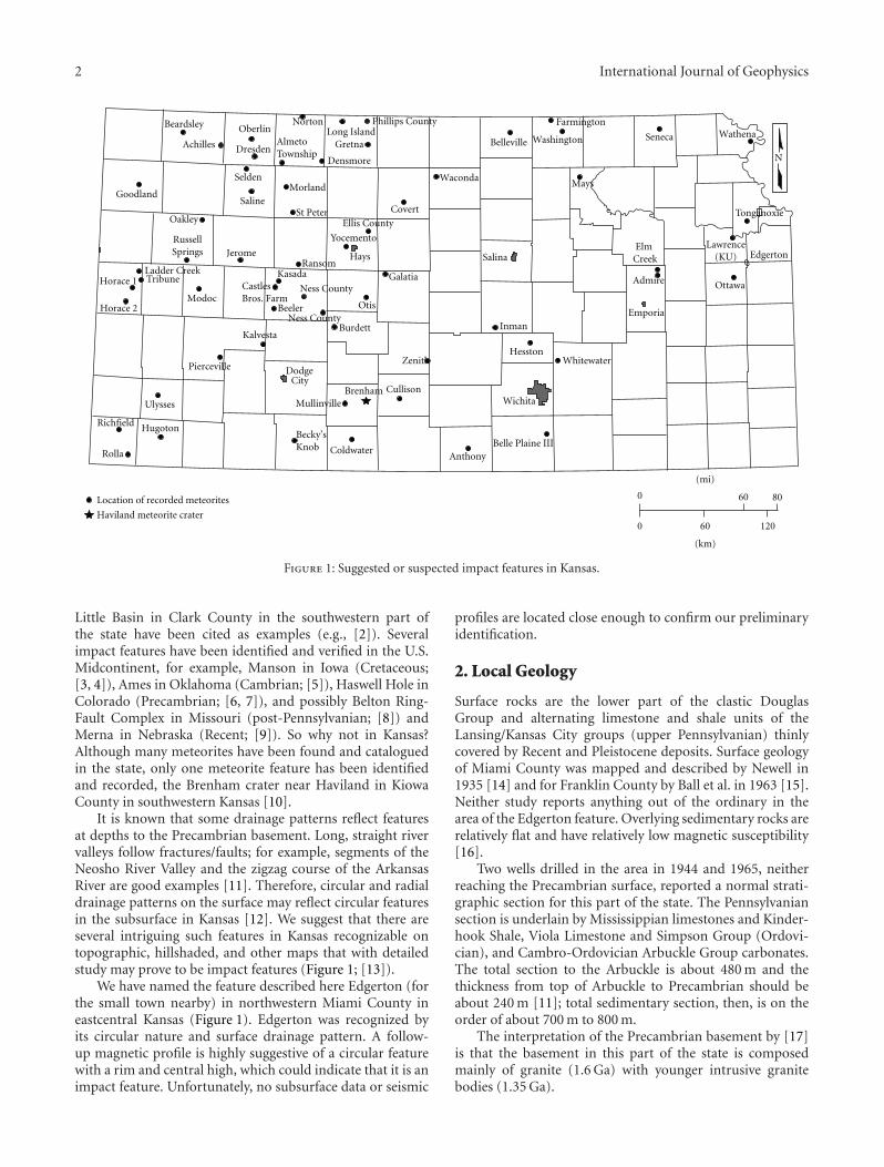
Figure 1: Suggested or suspected impact features in Kansas.
Little Basin in Clark County in the southwestern part ofthe state have been cited as examples (e.g., [2]). Severalimpact features have been identified and verified in the U.S.Midcontinent, for example, Manson in Iowa (Cretaceous;[3, 4]), Ames in Oklahoma (Cambrian; [5]), Haswell Hole inColorado (Precambrian; [6, 7]), and possibly Belton Ring-Fault Complex in Missouri (post-Pennsylvanian; [8]) andMerna in Nebraska (Recent; [9]). So why not in Kansas?Although many meteorites have been found and cataloguedin the state, only one meteorite feature has been identifiedand recorded, the Brenham crater near Haviland in KiowaCounty in southwestern Kansas [10].
It is known that some drainage patterns reflect featuresat depths to the Precambrian basement. Long, straight rivervalleys follow fractures/faults; for example, segments of theNeosho River Valley and the zigzag course of the ArkansasRiver are good examples [11]. Therefore, circular and radialdrainage patterns on the surface may reflect circular featuresin the subsurface in Kansas [12]. We suggest that there areseveral intriguing such features in Kansas recognizable ontopographic, hillshaded, and other maps that with detailedstudy may prove to be impact features (Figure 1; [13]).
We have named the feature described here Edgerton (forthe small town nearby) in northwestern Miami County ineastcentral Kansas (Figure 1). Edgerton was recognized byits circular nature and surface drainage pattern. A follow-up magnetic profile is highly suggestive of a circular featurewith a rim and central high, which could indicate that it is animpact feature. Unfortunately, no subsurface data or seismic
profiles are located close enough to confirm our preliminaryidentification.
2. Local Geology
Surface rocks are the lower part of the clastic DouglasGroup and alternating limestone and shale units of theLansing/Kansas City groups (upper Pennsylvanian) thinlycovered by Recent and Pleistocene deposits. Surface geologyof Miami County was mapped and described by Newell in1935 [14] and for Franklin County by Ball et al. in 1963 [15].Neither study reports anything out of the ordinary in thearea of the Edgerton feature. Overlying sedimentary rocks arerelatively flat and have relatively low magnetic susceptibility[16].
Two wells drilled in the area in 1944 and 1965, neitherreaching the Precambrian surface, reported a normal strati-graphic section for this part of the state. The Pennsylvaniansection is underlain by Mississippian limestones and Kinder-hook Shale, Viola Limestone and Simpson Group (Ordovi-cian), and Cambro-Ordovician Arbuckle Group carbonates.The total section to the Arbuckle is about 480 m and thethickness from top of Arbuckle to Precambrian should beabout 240 m [11]; total sedimentary section, then, is on theorder of about 700 m to 800 m.
The interpretation of the Precambrian basement by [17]is that the basement in this part of the state is composedmainly of granite (1.6 Ga) with younger intrusive granitebodies (1.35 Ga).
International Journal of Geophysics 3
(kilometers)
(miles)
0 1 2 3
0 21 3
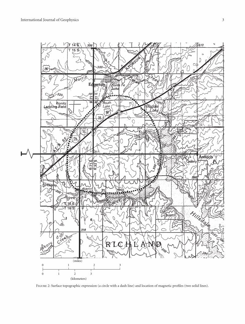
Figure 2: Surface topographic expression (a circle with a dash line) and location of magnetic profiles (two solid lines).

4 International Journal of Geophysics
−94.96−95−95.04−95.08
West longitude
−60
−40
−20
0
20
40
60
Tota
lmag
net
icfi
eld
anom
aly
(nT
)
Figure 3: Ground magnetic anomalies along east-west line afterdiurnal correction and spike and linear trend removal.
3. Edgerton Ring Surface Expression
It was the topographic ring or elliptical shape on the hillshademap near Edgerton that attracted attention. The slightlyelongated east-west feature is approximately 5.5 × 6.5 km.The features are emphasized by radial drainage with RockCreek and Bull Creek forming the southern and easternboundaries (Figure 2).
4. Geophysical Magnetic Survey
In December of 2004 surface east-west and north-southmagnetic profiles, based on accessibility of county roads,were made across the feature (Figure 2). Total magnetic fieldwas recorded with a Geometrics G858 cesium magnetometer.Data were acquired along a 12.8-km-long east-west line(longitude −95.0281 degrees) at the latitude 38.7229 degreesfrom the longitude −95.0914 to −94.9441 degrees and a12.8-km southnorth line near the center of the eastwest linefrom latitude 38.65 to 38.7821 degrees. Another GeometricsG856 Proton magnetometer was used to measure the diurnalchanges of the Earth’s field every 10 minutes at a fixed stationat the center of the two lines. The maximum diurnal changesduring the survey period of time were about 20 nT. Thenormal geomagnetic field in Miami County is 53,505 nT.
The field measurements were corrected for diurnal vari-ation. Magnetic spikes in the field measurements resultingfrom a highway overpass, a railroad, and utility lines wereremoved and replaced by the normal earth field value(53,505 nT). Small spikes resulting from culture noises wereremoved by the wavelet analysis [18]. A regional magneticfield was removed by a linear trend and Figure 3 is thefinal results of the ground magnetic feature. The maximumchange along the line is approximately 80 nT. It is interesting
−94.88−94.92−94.96−95−95.04−95.08
West longitude
1020
1040
1060
1080
1100
1120
Tota
lmag
net
icfi
eld
(nT
)(a)
−94.88−94.92−94.96−95−95.04−95.08
West longitude
−20
−10
0
10
20
Tota
lmag
net
icfi
eld
(nT
)
(b)
Figure 4: (a) Aeromagnetic data along latitude about N37.7382degrees with linear regional trend; (b) aeromagnetic anomaly withlinear regional field removed.
to note that there are almost identical anomaly highs (40 nT)at positions−94.9649 and−95.0593 degrees and a weak highat the center of the line (−6 km).
If we use the horizontal cylinder formula to estimatethe depth to an anomalous body [19], a maximum depthof about 1 km is computed for locations of −94.9649 and−95.0593 degrees. These locations suggest edges of thefeature.
International Journal of Geophysics 5
38.7638.7238.6838.64
North latitude
−20
−10
0
10
20
Tota
lmag
net
icfi
eld
anom
aly
(nT
)
Figure 5: Ground magnetic anomalies along southnorth line afterdiurnal correction, spike removal, and linear trend removal.
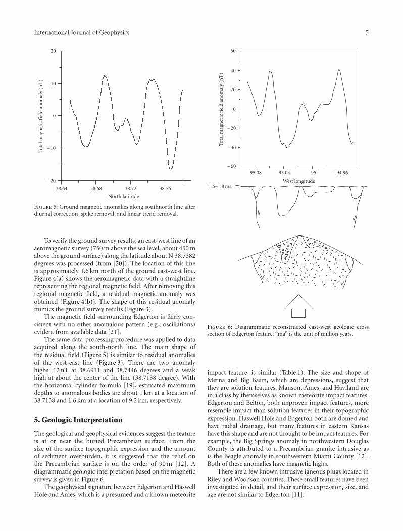
To verify the ground survey results, an east-west line of anaeromagnetic survey (750 m above the sea level, about 450 mabove the ground surface) along the latitude about N 38.7382degrees was processed (from [20]). The location of this lineis approximately 1.6 km north of the ground east-west line.Figure 4(a) shows the aeromagnetic data with a straightlinerepresenting the regional magnetic field. After removing thisregional magnetic field, a residual magnetic anomaly wasobtained (Figure 4(b)). The shape of this residual anomalymimics the ground survey results (Figure 3).
The magnetic field surrounding Edgerton is fairly con-sistent with no other anomalous pattern (e.g., oscillations)evident from available data [21].
The same data-processing procedure was applied to dataacquired along the south-north line. The main shape ofthe residual field (Figure 5) is similar to residual anomaliesof the west-east line (Figure 3). There are two anomalyhighs: 12 nT at 38.6911 and 38.7446 degrees and a weakhigh at about the center of the line (38.7138 degree). Withthe horizontal cylinder formula [19], estimated maximumdepths to anomalous bodies are about 1 km at a location of38.7138 and 1.6 km at a location of 9.2 km, respectively.
5. Geologic Interpretation
The geological and geophysical evidences suggest the featureis at or near the buried Precambrian surface. From thesize of the surface topographic expression and the amountof sediment overburden, it is suggested that the relief onthe Precambrian surface is on the order of 90 m [12]. Adiagrammatic geologic interpretation based on the magneticsurvey is given in Figure 6.
The geophysical signature between Edgerton and HaswellHole and Ames, which is a presumed and a known meteorite
−94.96−95−95.04−95.08
West longitude
−60
−40
−20
0
20
40
60
Tota
lmag
net
icfi
eld
anom
aly
(nT
)
1.6–1.8 ma
Figure 6: Diagrammatic reconstructed east-west geologic crosssection of Edgerton feature. “ma” is the unit of million years.
impact feature, is similar (Table 1). The size and shape ofMerna and Big Basin, which are depressions, suggest thatthey are solution features. Manson, Ames, and Haviland arein a class by themselves as known meteorite impact features.Edgerton and Belton, both unproven impact features, moreresemble impact than solution features in their topographicexpression. Haswell Hole and Edgerton both are domed andhave radial drainage, but many features in eastern Kansashave this shape and are not thought to be impact features. Forexample, the Big Springs anomaly in northwestern DouglasCounty is attributed to a Precambrian granite intrusive asis the Beagle anomaly in southwestern Miami County [12].Both of these anomalies have magnetic highs.
There are a few known intrusive igneous plugs located inRiley and Woodson counties. These small features have beeninvestigated in detail, and their surface expression, size, andage are not similar to Edgerton [11].
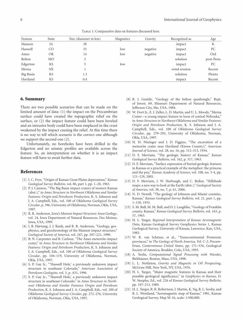
6 International Journal of Geophysics
Table 1: Comparative data on features discussed here.
Feature State Size (diameter in km) Magnetics Gravity Recognized as Age
Manson IA 38 impact K
Haswell CO 35 low negative impact PC
Ames OK 14 low negative impact Ord
Belton MO 3 solution post-Penn
Edgerton KS 5 low impact PC
Merna NE 1 wind erosion Recent
Big Basin KS 1.3 solution Pleisto
Haviland KS 0.4 impact Recent
6. Summary
There are two possible scenarios that can be made on thelimited amount of data: (1) the impact on the Precambriansurface could have created the topographic relief on thesurface, or (2) the impact feature could have been beveledand an intrusive body could have been emplaced in the crustweakened by the impact causing the relief. At this time thereis no way to tell which scenario is the correct one althoughwe support the second one (2).
Unfortunately, no boreholes have been drilled in theEdgerton and no seismic profiles are available across thefeature. So, an interpretation on whether it is an impactfeature will have to await further data.
References
[1] J. C. Frye, “Origin of Kansas Great Plains depressions,” KansasGeological Survey Bulletin, vol. 86, part 1, pp. 1–20, 1963.
[2] P. J. Cannon, “The Big Basin impact craters of western Kansas(abst.),” in Ames Structure in Northwest Oklahoma and SimilarFeatures: Origin and Petroleum Production, K. S. Johnson andJ. A. Campbell, Eds., vol. 100 of Oklahoma Geological SurveyCircular, p. 396, University of Oklahoma, Norman, Okla, USA,1997.
[3] R. R. Anderson, Iowa’s Manson Impact Structure: Iowa Geology,vol. 24, Iowa Department of Natural Resources, Des Moines,Iowa, USA, 1999.
[4] J. B. Hartung, J. J. Kunk, and R. R. Anderson, “Geology, geo-physics, and geochronology of the Manson impact structure,”Geological Society of America, vol. 247, pp. 207–221, 1990.
[5] B. N. Carpenter and R. Carlson, “The Ames meteorite-impactcrater,” in Ames Structure in Northwest Oklahoma and SimilarFeatures: Origin and Petroleum Production, K. S. Johnson andJ. A. Campbell, Eds., vol. 100 of Oklahoma Geological SurveyCircular, pp. 104–119, University of Oklahoma, Norman,Okla, USA, 1997.
[6] S. P. Gay Jr., “‘Haswell Hole,’ a previously unknown impactstructure in southeast Colorado,” American Association ofPetroleum Geologists, vol. 5, p. A51, 1996.
[7] S. P. Gay Jr., “‘Haswell Hole,’ a previously unknown impactstructure in southeast Colorado,” in Ames Structure in North-west Oklahoma and Similar Features: Origin and PetroleumProduction, K. S. Johnson and J. A. Campbell, Eds., vol. 100 ofOklahoma Geological Survey Circular, pp. 272–276, Universityof Oklahoma, Norman, Okla, USA, 1997.
[8] R. J. Gentile, “Geology of the belton quadrangle,” Rept.of Invest. 69, Missouri Department of Natural Resources,Jefferson City, Mo, USA, 1984.
[9] W. Dort Jr., E. J. Zeller, L. D. Martin, and U. L. Moody, “MernaCrater—a young impact feature in loess of central Nebraska,”in Ames Structure in Northwest Oklahoma and Similar Features:Origin and Petroleum Production, K. S. Johnson and J. A.Campbell, Eds., vol. 100 of Oklahoma Geological SurveyCircular, pp. 279–293, University of Oklahoma, Norman,Okla, USA, 1997.
[10] H. H. Nininger and J. D. Figgins, “The excavation of ameteorite crater near Haviland (Kiowa County),” AmericanJournal of Science, vol. 28, no. 16, pp. 312–313, 1934.
[11] D. F. Merriam, “The geologic history of Kansas,” KansasGeological Survey Bulletin, vol. 162, p. 317, 1963.
[12] D. F. Merriam, “Surface expression of buried geologic featuresin Kansas or a practical example of the metaphor: the princessand the pea,” Kansas Academy of Science, vol. 108, no. 3-4, pp.121–129, 2005.
[13] D. F. Merriam, J. W. Harbaugh, and C. Beiker, “Hillshademaps: a new way to look at the Earth (abst.),” Geological Societyof America, vol. 38, no. 7, p. 61, 2006.
[14] N. D. Newell, “The geology of Johnson and Miami counties,Kansas,” Kansas Geological Survey Bulletin, vol. 21, part 1, pp.1–150, 1935.
[15] S. M. Ball, M. M. Ball, and D. J. Laughlin, “Geology of Franklincounty, Kansas,” Kansas Geological Survey Bulletin, vol. 163, p.57, 1963.
[16] H. L. Yarger, Regional Interpretation of Kansas AeromagneticData, Kansas Geological Survey Geophysics Series 1, KansasGeological Survey, University of Kansas, Lawrence, Kan, USA,1983.
[17] W. R. van Schmus, et al., “Transcontinental Proterozicprovinces,” in The Geology of North America, Vol. C-2, Precam-brian, Conterminous United States, pp. 171–334, GeologicalSociety of America, Boulder, Colo, USA, 1993.
[18] A. Teolis, Computational Signal Processing with Wavelet,Birkhauser, Boston, Mass, USA, 1998.
[19] L. L. Nettleton, Gravity and Magnetic in Oil Prospecting,McGraw Hill, New York, NY, USA, 1976.
[20] H. L. Yarger, “Major magnetic features in Kansas and theirpossible geological significance,” in Geophysics in Kansas, D.W. Steeples, Ed., vol. 226 of Kansas Geological Survey Bulletin,pp. 197–213, 1989.
[21] H. L. Yarger, R. R. Robertson, J. Martin, K. Ng, R. L. Sooby, andR. L. Wentland, “Aeromagnetic map of Kansas,” 1981, KansasGeological Survey, Map M-16, scale: 1:500,000.

Submit your manuscripts athttp://www.hindawi.com
Hindawi Publishing Corporationhttp://www.hindawi.com
Volume 2013
Geological ResearchJournal of
Volume 2013
ISRN Paleontology
Hindawi Publishing Corporationhttp://www.hindawi.com
Geochemistry
Hindawi Publishing Corporationhttp://www.hindawi.com Volume 2013
Journal of
ISRN Geophysics
Hindawi Publishing Corporationhttp://www.hindawi.com Volume 2013
Journal ofPetroleum Engineering
Hindawi Publishing Corporationhttp://www.hindawi.com Volume 2013
Paleontology JournalHindawi Publishing Corporationhttp://www.hindawi.com Volume 2013
OceanographyInternational Journal of
Hindawi Publishing Corporationhttp://www.hindawi.com Volume 2013
ISRN Oceanography
Hindawi Publishing Corporationhttp://www.hindawi.com Volume 2013
EarthquakesJournal of
Hindawi Publishing Corporationhttp://www.hindawi.com Volume 2013
Hindawi Publishing Corporation http://www.hindawi.com Volume 2013
International Journal of
Geophysics
ISRN Atmospheric Sciences
Hindawi Publishing Corporationhttp://www.hindawi.com Volume 2013
Hindawi Publishing Corporationhttp://www.hindawi.com Volume 2013
MineralogyInternational Journal of
ISRN Meteorology
Hindawi Publishing Corporationhttp://www.hindawi.com Volume 2013
Meteorology
Hindawi Publishing Corporationhttp://www.hindawi.com Volume 2013
Advances in
Hindawi Publishing Corporation http://www.hindawi.com Volume 2013Hindawi Publishing Corporation http://www.hindawi.com Volume 2013
The Scientific World Journal
Mining
Hindawi Publishing Corporationhttp://www.hindawi.com Volume 2013
Journal of
ScientificaHindawi Publishing Corporationhttp://www.hindawi.com Volume 2013
ISRN Geology
Hindawi Publishing Corporationhttp://www.hindawi.com Volume 2013
Atmospheric SciencesInternational Journal of
Hindawi Publishing Corporationhttp://www.hindawi.com Volume 2013