REQUEST FOR PROPOSALS: ASSINIBOINE RIVER AND LAKE MANITOBA...
20
Water Control Systems Management Branch REQUEST FOR PROPOSALS: ASSINIBOINE RIVER AND LAKE MANITOBA BASINS FLOOD MITIGATION STUDY May 2012
Transcript of REQUEST FOR PROPOSALS: ASSINIBOINE RIVER AND LAKE MANITOBA...

Water Control Systems Management Branch
REQUEST FOR PROPOSALS:
ASSINIBOINE RIVER AND LAKE MANITOBA BASINS FLOOD MITIGATION STUDY
May 2012
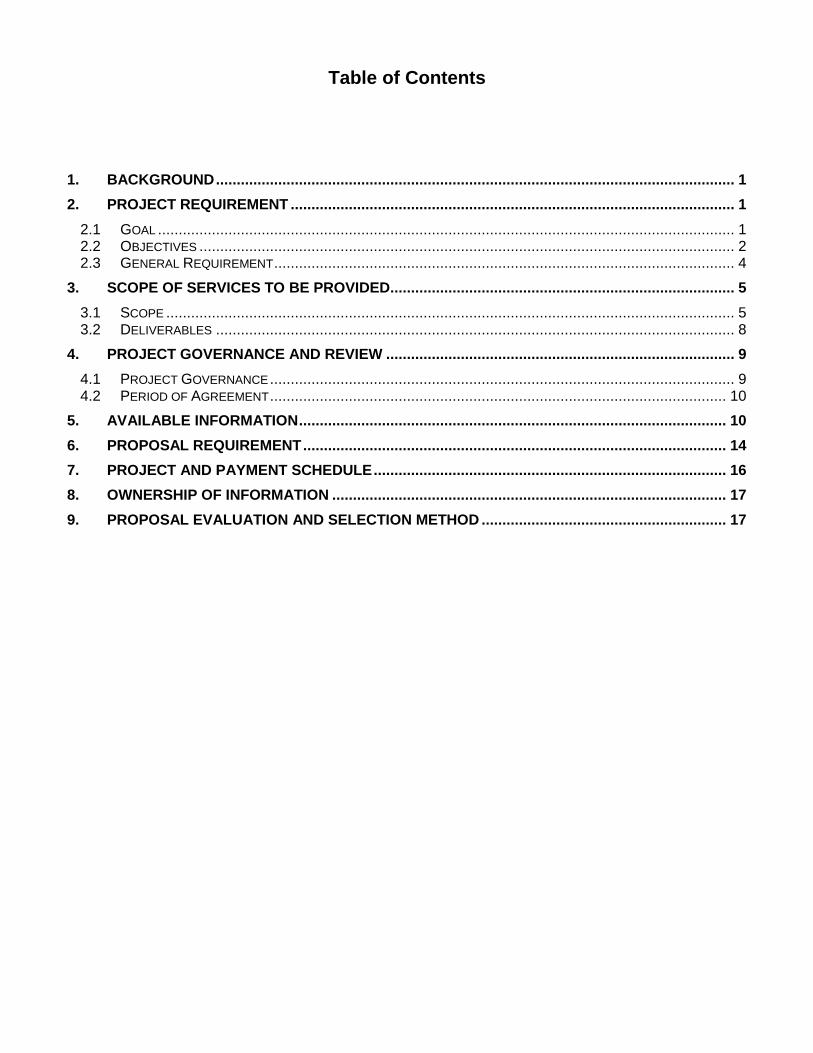
Table of Contents
1. BACKGROUND ............................................................................................................................. 1
2. PROJECT REQUIREMENT ........................................................................................................... 1
2.1 GOAL ........................................................................................................................................... 1 2.2 OBJECTIVES ................................................................................................................................. 2 2.3 GENERAL REQUIREMENT ............................................................................................................... 4
3. SCOPE OF SERVICES TO BE PROVIDED ................................................................................... 5
3.1 SCOPE ......................................................................................................................................... 5 3.2 DELIVERABLES ............................................................................................................................. 8
4. PROJECT GOVERNANCE AND REVIEW .................................................................................... 9
4.1 PROJECT GOVERNANCE ................................................................................................................ 9 4.2 PERIOD OF AGREEMENT .............................................................................................................. 10
5. AVAILABLE INFORMATION ....................................................................................................... 10
6. PROPOSAL REQUIREMENT ...................................................................................................... 14
7. PROJECT AND PAYMENT SCHEDULE ..................................................................................... 16
8. OWNERSHIP OF INFORMATION ............................................................................................... 17
9. PROPOSAL EVALUATION AND SELECTION METHOD ........................................................... 17

REQUEST FOR PROPOSAL FOR ASSINIBOINE RIVER AND LAKE MANITOBA BASINS FLOOD MITIGATION STUDY
Manitoba Infrastructure and Transportation (MIT) requests the services of an Engineering Service Provider (ESP) to conduct a comprehensive conceptual level flood mitigation study for the Assiniboine River and Lake Manitoba basins.
1. BACKGROUND
In the last hundred years there have been at least six major floods on the Assiniboine River, the most recent in 1976, 1995 and 2011. As well, on the Souris River there have been at least six major floods, the most recent in 1976, 1999 and 2011. Each event was unique in peaks, volumes and timing. Serious flooding on Lake Manitoba has been less frequent with the most serious before 2011 occurring in 1954, 1955 and 1956. Major flooding has not happened on Lake Manitoba since the Fairford River Control Structure was completed in 1961. The highest level occurred in 1979, 1.2 meters below the 2011 level and 0.84 meters below 1955. The flood of 2011 was remarkable in a number of ways. Virtually every Assiniboine River and Souris River tributary carried near record peak flows and volumes of water. Although not quite as extreme, very high flows were recorded on almost all streams and rivers in the Lake Manitoba watershed as well. For a flood event like this to occur on one or two major rivers is rare. For this to occur over all of western Manitoba is extremely rare and has highlighted several vulnerabilities in some of the existing flood control systems. Major flood protection on the Assiniboine River is provided by the Shellmouth Reservoir, the Portage Diversion and dikes between Portage la Prairie and Winnipeg. The latter two were tested to their limits in 2011. Other than dikes in Melita and Souris there are few flood control works on the Souris River in Manitoba. Manitoba also receives some flood protection benefits from significant storage in major reservoirs in Saskatchewan and North Dakota but even these were overwhelmed in 2011.
2. PROJECT REQUIREMENT
2.1 Goal Manitoba Infrastructure and Transportation (MIT) is requesting the services of an Engineering Service Provider (ESP) to provide a conceptual level study for the Assiniboine River and Lake Manitoba watersheds and make recommendations on how future flood events can be mitigated on the main stems of the Assiniboine River and Souris River, and around Lake Manitoba, Lake St. Martin, Dauphin Lake and Shoal Lakes. The study will include examination of a wide range of possible measures including non-structural measures, such as land use changes as well as structural measures, such as large dams. The ESP will as much as possible quantify the potential benefits, costs, implications and risks related to the various options. A desk top literature review is to be performed of viable projects that could be implemented in upstream jurisdictions. The results of this study will be the foundation for flood mitigation programs for the next few decades. Much of this work requires the review and updating of previous studies of projects proposed by various stakeholders. Projects and options that are determined to clearly have low benefits should be examined in a more cursory manner, and an explanation given as to why the benefits are so low.

2
It should be noted that a review is being conducted of the 2011 flood by an independent task force, with a goal of identifying improvements that can be made to infrastructure, amongst other things. As well, a review is being conducted of the desirable water level range for Lake Manitoba and Lake St. Martin. These reviews are scheduled to be completed in the fall of 2012 and the outputs of these reviews are to be used as inputs to this study.
2.2 Objectives
Manitoba Infrastructure and Transportation is requiring a comprehensive conceptual-level study that will identify and assess potential options to reduce flood risk for communities and major infrastructure along the Assiniboine River, Souris River, Qu’Appelle River, Dauphin Lake, Lake Manitoba, Fairford River, Lake St. Martin, Dauphin River and Shoal Lakes. A number of flood mitigation initiatives are currently well underway, and these are to be considered in the study assessments and analyses. The initiatives underway include the 2010 and 2011 Individual Flood Protection Initiatives (IFPI), numerous feasibility studies for community diking, City of Brandon dike enhancement, community dike construction and enhancements for some communities along the Assiniboine River, the Souris River and Lake Manitoba, Lake St. Martin outlet channel, Lake St. Martin diking, Dauphin River diking and the Lake St Martin flood mitigation study. These are in addition to existing flood mitigation infrastructure, such as the Shellmouth Dam and Reservoir, the Portage Diversion, the Fairford River Control Structure. During a typical flood season, a portion of the Assiniboine River’s flood waters are stored in the Shellmouth Reservoir and a portion of it is diverted from the Assiniboine River to Lake Manitoba through the Portage Diversion. The operation of these hydraulic structures is for the flood protection of downstream communities along the Assiniboine River and the City of Winnipeg and, therefore, the structures are operated in conjunction with the Red River Floodway. Water is also released from Lake Manitoba to Lake St. Martin through the Fairford River Control Structure. The majority of the inflow to Lake Manitoba, however, is contributed from Lake Winnipegosis through the Waterhen River. This interconnected system will require an analysis of the system as a single unit to identify flood mitigation options to reduce flood risk within that part of the basin. The ESP will undertake a conceptual level study and will make recommendations regarding flood mitigation solutions for the study area, as detailed below.
2.2.1 Upper Assiniboine River:
Communities and infrastructure along the upper Assiniboine River (upstream of Holland) are in one of the areas that was most affected by the 2011 flood. The study will examine the adequacy of existing (flood mitigation/protection) infrastructure and examine options to reduce flood risk, and will make recommendations regarding economically and technically feasible flood mitigation alternatives along the Assiniboine River.
3
2.2.2 Souris River:
Communities along the Souris River were also severely affected by the flood of 2011. Some major structural flood mitigation measures have been implemented along the Souris River. The study will assess and recommend on flood mitigation alternatives for communities and infrastructure along the Souris River.
2.2.3 Lower Assiniboine River:
Communities and infrastructure along the lower Assiniboine River (downstream of Holland to Winnipeg) are also in one of the areas most affected by the 2011 flood. The study will examine the adequacy of existing (flood mitigation/protection) infrastructure and examine options to reduce flood risk, and will make recommendations regarding flood mitigation alternatives. The options should include, as a minimum:
Increasing the capacity of the Assiniboine River downstream of Portage la Prairie to Winnipeg (a combination of river expansion and upgraded diking)
Increasing the capacity of the Portage Diversion The damages and impacts of not improving the flood control infrastructure in this area will be part of the study analyses.
2.2.4 Lake Manitoba and Lake St. Martin:
High water levels due to inflows from Lake Winnipegosis/ Dauphin River, the Portage Diversion and local runoff coupled with excessive wave action caused serious damage to home, farms, businesses, and cottages along Lake Manitoba during the flood season of 2011. The Fairford River Control Structure was operated close to the maximum capacity and, as a consequence, water levels on Lake St Martin were excessively high, with very significant flood impacts on adjacent communities. The study will assess the existing, underway, and proposed flood mitigation infrastructure, utilize the findings of flood mitigation studies (including very recent studies), assess options for improved and additional flood mitigation works (including the need for a permanent outlet channel from Lake St. Martin and an additional outlet from Lake Manitoba), and make recommendations regarding flood mitigation alternatives for communities and residents.
2.2.5 Dauphin Lake: Homes and cottages along Dauphin Lake were severely affected during the 2011 flood. Several efforts have been made to control lake level in the last century. In 1964, the Mossey River Dam, The ten bay concrete stoplog structure, was constructed at Terin's Landing at the outlet of the lake. The dam can restrict the outflow when conditions are dry and levels low but the river limits the outflow when the lake is high. Regulation of the lake is difficult. Conditions can change very quickly. For example a four day rain in June 1947 produced an estimated peak inflow
4
to the lake of 60,000 cfs (1,700 m3/s). At normal levels, the Mossey River can only take out about 500 cfs (14 m3/s) from the lake. The ESP will assess and recommend on the possible flood mitigation options for Dauphin Lake including a desirable water level range for the lake.
2.2.6 The Qu'Appelle River: The Qu’Appelle River is a river that flows 430 km east from Lake Diefenbaker in southwestern Saskatchewan to join the Assiniboine River in Manitoba, just south of Lake of the Prairies, near the village of St. Lazare. With the construction of the Qu'Appelle River Dam and Gardiner Dam upstream water flow was significantly increased and regulated. Most of the Qu'Appelle River's present flow is actually water diverted from the South Saskatchewan River. In the 2011 flood, the Qu’Appelle River contributed to damages at the community of St. Lazare. The ESP will conduct a conceptual level assessment and provide recommendation on possible flood mitigation measures for the communities and infrastructure that are directly affected by the river.
2.2.7 The City of Winnipeg: The City of Winnipeg’s flood protection system consists of non-structural and structural components. The non-structural components include legislation, policies, studies, and regular reporting. The structural components are the physical structures that divert or hold back water. The structural components include the major flood control works (Shellmouth Dam and Reservoir, Portage Diversion and the Red River Floodway), as well as all the structures associated with the City’s primary diking system and other miscellaneous controls. Hence, any alteration in the capacity or in the operation of the Portage Diversion or the Shellmouth Dam will have direct impact on the flood control methodology of the City of Winnipeg. The ESP will assess the benefits to Winnipeg’s flood protection capability of any relevant flood mitigation options examined in this study.
2.3 General Requirement The ESP shall meet the following requirements:
Possess adequate Professional Liability insurance coverage.
Be registered or licensed to practice with the Association of Professional Engineers and Geoscientists of Manitoba (APEGM) and shall abide by the Association's regulations, code of ethics and bylaws. Any sub-ESP`s hired by the ESP shall also be registered or licensed to practice with the Association of Professional Engineers and Geoscientists of Manitoba (APEGM) and shall abide by the Association's regulations, code of ethics and bylaws.
The ESP shall abide by the following design codes, standards, guidelines, requirements, policies and manuals:
Manitoba Workplace Health and Safety Act and Regulations (latest edition)

5
MIT’s ESP Engagement and Administration Manual. (latest edition).
MIT’s Structures Design Manual. (latest edition)
Department’s Standard Drawings and Details (latest version)
3. SCOPE OF SERVICES TO BE PROVIDED
3.1 Scope Below are some of the key elements of the required flood mitigation study.
3.1.1 Existing Vulnerabilities:
The study will detail all the major flood vulnerabilities throughout the study area. The current state of flood control works will be analyzed with respect to the infrastructure integrity, operational and public safety vulnerabilities, and how they could be improved.
3.1.2 Modeling: To assist in the evaluation of various flood mitigation options it may be necessary for the ESP to develop a computer model or more than one model for assessing some hydrologic or hydraulic aspects. It is understood that any models developed will likely be of a coarse nature because of the limited readily available input data, and the timeframes for this study.
3.1.3 Development Controls: The ESP should assess where development should be prohibited or restricted, ways that development could be limited, and ways that developments could be modified to reduce flood damages and flood fighting and other costs. This is not to be limited to existing communities but should include any significant developments within the study area. The ESP should identify all vulnerabilities for communities and the City of Winnipeg. The ESP should note that at this stage of the study it is not required to undertake flood risk mapping.
3.1.4 Land Use: Land use has an impact, sometimes a large impact, on the hydrology of an area. Generally, a large portion of precipitation runs off in urban areas, less runs off of cultivated land, less off of pasture or grass land, and even less runs off of wooded lands. The ESP will examine the potential impacts and benefits of land use changes, and identify opportunities that may still exist to preserve, expand or enhance significant areas with lower runoff potential. The ESP will also recommend possible

6
policies that could be adopted (or existing policies that could be enhanced) to encourage low runoff land use.
3.1.5 Wetlands: Wetlands are extensive throughout western Manitoba but their number is decreasing. Wetlands provide many benefits including water storage and reduced runoff flows. The ESP will quantify the benefits of wetlands in reducing flood damages and how benefits vary for different flood magnitudes, and examine options for enhancing and increasing the number of wetlands within Manitoba.
3.1.6 Diversions: The ESP will evaluate and assess potential, new diversion schemes for flood mitigation. Improvements and enlargements to the Portage Diversion and the Fairford River Control Structure will be examined, including costs, benefits, and environmental and social impacts. Particular attention will be given to the emergency outlet from Lake St. Martin in determining appropriate channel sizes, control structures, benefits, costs, environmental impacts, other implications and whether permanent works are economically and technically justified.
3.1.7 Community Dikes: Melita, Souris, Brandon, St. Lazare, Wawanesa and Spruce Woods Provincial Park have existing flood control dikes. Recently, a number of diking initiatives are being implemented, such as the 2010 and 2011 Individual Flood Protection Initiatives (IFPI), City of Brandon dike enhancements, community dike enhancements for some communities along the Assiniboine and Souris Rivers, Lake Manitoba, Lake St. Martin and Dauphin River. The ESP will review the adequacy of existing and proposed dikes and will assess the feasibility of new diking options.
3.1.8 Flood Storage Reservoirs: Various agencies have studied a number of potential flood storage dams in past decades. These range from small reservoirs with drainage areas less than a square mile, to very large dams like the proposed Holland Dam. Many of these were considered ineffective, too costly or otherwise impractical.
The ESP will provide an updated analysis of all the larger dams that have been looked at in the past both within Manitoba and upstream jurisdictions, and identify and assess promising additional sites within Manitoba only. Where the benefits are clearly small, the analysis should be cursory. However, it is expected that the most feasible and beneficial 5 to 10 sites will warrant a more detailed, conceptual-level analysis. Throughout the study it will be assumed that the proposed leaf gate addition on the Shellmouth Dam is in place with the associated additional flood

7
storage capacity. The ESP will recommend if there are any other opportunities to improve the dam’s effectiveness in reducing flood damages in the study area. The ESP will examine the option of construction of a multitude of small dams sufficient to reduce the impact of large floods. This examination will include an assessment of the availability and feasibility of suitable locations for storage areas.
3.1.9 Lake Winnipegosis: The largest portion of flows into Lake Manitoba comes from Lake Winnipegosis and as such, the ESP will also examine the potential to regulate Lake Winnipegosis to enhance flood protection on Lake Winnipegosis and Lake Manitoba.
3.1.10 Lower Assiniboine: The dikes on the Assiniboine River downstream of Portage la Prairie were tested to their limits in the flood of 2011 and it was found that their capacity was less than expected. The ESP will identify options, undertake an assessment, and provide a summary on the benefits and costs of enhancing the capacity of the river and dikes. The study will identify and assess the implications of these options as well as the implications of not enhancing the capacity. The study will also identify and assess other options of dealing with extreme events and provide a summary on the benefits and costs of the options.
3.1.11 Lake Manitoba: Many buildings and structures around Lake Manitoba were damaged or destroyed in the spring and summer of 2011. The Province has initiated a flood mitigation program to provide financial assistance for individual flood protection works. The study will report on vulnerabilities that will remain after the current programs are completed. Recommendations will be made on how these can be mitigated together with benefits, costs and implications. Moreover, the ESP will assess options to increase outflow from Lake Manitoba and Lake St. Martin, in alignment with the conclusion of Lake Manitoba/Lake St. Martin Water Level Regulation Studies.
3.1.12 Shoal Lakes: High water levels on the Shoal Lakes during several years in the past decade or more have caused damages to adjacent land used for agricultural purposes as well as to some infrastructure and privately-owned structures. A recent watershed study was conducted to examine options for alleviating flooding of the lands surrounding the Shoal Lakes. The ESP will incorporate the findings of this study into its assessment of potential flood mitigation options.
8
3.1.13 Temporary flood mitigation options: In some instances, permanent flood mitigation options are either not feasible or not economical to implement. This could be especially true when flood damages are caused only in larger, rarer events, like the flood of 2011. The ESP will assess in which geographic locations temporary flood mitigation options may be more suitable than permanent flood mitigation options (sandbags, aquadams, flood tubes, etc).
3.1.14 Benefit - Cost Analysis and Prioritization: The ESP will evaluate and quantify benefits, costs and other implications of all the alternatives studied. This analysis will be at a conceptual level. It will be less detailed for the options that clearly have low benefits. Benefits that accrue in smaller and summer events will be included in the analysis. The benefits of a given alternative should include the benefits of averting damage to real property, lost income, lost crops, losing homes for an evacuation period, stress, lost business, limited development opportunities, transportation restrictions etc. Determining some benefits (like reduction in stress) can be quite subjective and it may require interviewing a cross section of the public for their views and then estimating a reasonable value or range of values. A benefit-cost analysis will be conducted for each alternative that is deemed to be potentially feasible. While conducting the benefit cost analysis, the ESP will consider a wide range of frequencies including a 100 year event 500 year event and the flood of record. The ESP is also required to develop a methodology of prioritizing the various alternatives. Alternatives should be prioritized based on the benefit-cost ratio, the location of the project, its significance in improving flood protection for the City of Winnipeg, and other relevant criteria.
3.1.15 Environmental and Social Impacts of the alternatives The report should identify the environmental and social impacts of the recommended options including all potentially impacted resources and environmental issues such as fish, waterfowl, wildlife, haylands, livestock, water quality.
3.2 Deliverables
3.2.1 Draft Report a) The ESP will present one electronic copy (MS Word format) and 12 copies of a
draft report to the Technical Advisory Committee. The draft report will document the flood mitigation options considered, including the option details, the benefits, costs and implications of the options, as well as all other aspects of the study.

9
The ESP may provide the draft report in sections/chapters, as each component of the assignment is completed.
b) The Technical Advisory Committee will review the draft report and will hold a
meeting with the ESP to provide feedback and direction.
3.2.2 Final Report a) The ESP will develop and produce its Final Report (30 copies) and one electronic
copy (MS Word format) by the date indicated in 7.2a. b) The ESP must be available to the Technical Advisory Committee for follow up
questions concerning the Final Report.
3.2.3 Legacy Tools: The ESP will provide the legacy tools that have been used in the study once the study is completed. Legacy tools refer to any systems, software, Microsoft Excel codes, GIS and AutoCAD inscriptions, etc. that the ESP has used to accomplish the tasks. These legacy tools will be used by MIT in similar future studies. Hence, the ESP will describe the techniques and usage of the tools, the key assumptions made in developing the tools, and the limitations of the tools.
4. PROJECT GOVERNANCE AND REVIEW
4.1 Project Governance The overall governance regarding project scope and other such matters will be provided by a Steering Committee. The Steering Committee is comprised of staff from Conservation and Water Stewardship (MCWS), and from Infrastructure and Transportation (MIT). Direct communication throughout the duration of the project with the ESP will be through the Technical Advisory Committee.
4.1.1 Technical Advisory Committee To provide guidance to the ESP a Technical Advisory Committee (TAC), which will include a broad range of technical and non technical people, will be formed with representation from MCWS, MIT, Conservation Districts (CD’s), Manitoba Agriculture, Food and Rural Initiatives (MAFRI), Emergency Measures Organization (EMO), and local governments and local citizen groups.
The ESP will conduct a minimum of 6 and a maximum of 8 meetings with the TAC to summarize study results, provide updates on the progress of the work, and seek input from the TAC. The ESP will propose milestones at which these meetings are to

10
take place. Before each meeting the ESP will prepare a document outlining the progress and what topics will be up for discussion at the next meeting. This document will be emailed or mailed at least a week before the meeting to all members of the TAC. The majority of the meetings will be at a location within Winnipeg; approximately two of the meetings could be in a community elsewhere in southern Manitoba. Each meeting will be approximately three hours in duration.
4.1.2 Technical Workshop (Symposium) A technical workshop will be developed jointly by the TAC and ESP as the first step towards to obtaining technical input on the study. The ESP and TAC will select and invite technical people with experience in Manitoba floods from various government and non government sectors to attend the workshop. The ESP will collect necessary background information and will conduct a literature review prior to the workshop and will present the findings to the invitees.
4.1.3 Public Meetings The ESP will conduct a minimum of two presentations (half day open houses) in three different locations. That is, the ESP will hold a minimum of six half-day open houses in various communities throughout western Manitoba (probably in Brandon, Ashern and Portage la Prairie). The first presentation will be conducted in the early stages of the project and the second presentation will be conducted when the study is nearing completion (or at some other time directed by the TAC). The purpose of the meetings will be to inform the public about the initiated study, to discuss the goals of the study, and to obtain public input that may help during the study period, and to inform the public on the findings of the study. The public will be encouraged to provide input either at the open houses or by email, mail etc.
4.2 Period of Agreement Work under the Agreement shall commence as soon as practicable after the date of signing, and shall be completed within 18 months duration.
5. AVAILABLE INFORMATION
Manitoba will provide to the ESP available information on the existing and proposed flood mitigation infrastructure and the completed flood mitigation studies; available topographic, hydrologic, and hydrometric information; and any available hydrologic and hydraulic models. The ESP will be provided with the following:
Shoal Lakes Watershed Study Report (2011)
Shoal Lakes Water Management Options – Preliminary Investigation (2002)
Upper Assiniboine River Basin Study Appendix A to F (2000)
11
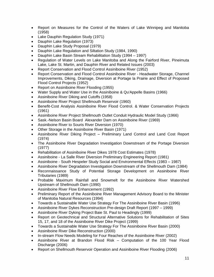
Report on Measures for the Control of the Waters of Lake Winnipeg and Manitoba (1958)
Lake Dauphin Regulation Study (1971)
Dauphin Lake Regulation (1973)
Dauphin Lake Study Proposal (1979)
Dauphin Lake Regulation and Siltation Study (1984, 1990)
Dauphin Lake Basin Stream Rehabilitation Study (1994 – 1997)
Regulation of Water Levels on Lake Manitoba and Along the Fairford River, Pineimuta Lake, Lake St. Martin, and Dauphin River and Related Issues (2003)
Report Conservation and Flood Control Assiniboine River (1952)
Report Conservation and Flood Control Assiniboine River - Headwater Storage, Channel Improvements, Diking, Drainage, Diversion at Portage la Prairie and Effect of Proposed Flood Control Projects (1952)
Report on Assiniboine River Flooding (1955)
Water Supply and Water Use in the Assiniboine & Qu'Appelle Basins (1966)
Assiniboine River Diking and Cutoffs (1958)
Assiniboine River Project Shellmouth Reservoir (1960)
Benefit-Cost Analysis Assiniboine River Flood Control. & Water Conservation Projects (1961)
Assiniboine River Project Shellmouth Outlet Conduit Hydraulic Model Study (1966)
Sask.-Nelson Basin Board Alexander Dam on Assiniboine River (1969)
Assiniboine River to Souris River Diversion (1970)
Other Storage in the Assiniboine River Basin (1971)
Assiniboine River Diking Project – Preliminary Land Control and Land Cost Report (1974)
The Assiniboine River Degradation Investigation Downstream of the Portage Diversion (1977)
Rehabilitation of Assiniboine River Dikes 1978 Cost Estimates (1978)
Assiniboine - La Salle River Diversion Preliminary Engineering Report (1981)
Assiniboine - South Hespeler Study Social and Environmental Effects (1983 – 1987)
Assiniboine River Degradation Investigation Downstream of the Shellmouth Dam (1984)
Reconnaissance Study of Potential Storage Development on Assiniboine River Tributaries (1989)
Probable Maximum Rainfall and Snowmelt for the Assiniboine River Watershed Upstream of Shellmouth Dam (1990)
Assiniboine River Flow Enhancement (1992)
Preliminary Report of the Assiniboine River Management Advisory Board to the Minister of Manitoba Natural Resources (1994)
Towards a Sustainable Water Use Strategy For The Assiniboine River Basin (1996)
Assiniboine River Dykes Reconstruction Pre-design Draft Report (1997 – 1999)
Assiniboine River Dyking Project Baie St. Paul to Headingly (1999)
Report on Geotechnical and Structural Alternative Solutions for Rehabilitation of Sites 15, 17, and 18 of the Assiniboine River Dike Project (1999)
Towards a Sustainable Water Use Strategy For The Assiniboine River Basin (2000)
Assiniboine River Dike Reconstruction (2000)
In-stream Flow Needs Modeling for Four Reaches of the Assiniboine River (2002)
Assiniboine River at Brandon Flood Risk – Computation of the 100 Year Flood Discharge (2006)
Report on Shellmouth Reservoir Operation and Assiniboine River Flooding (2006)

12
Assiniboine River Water Management Model Documentation (2007)
Assiniboine River Hydrodynamic Modeling Study (being completed)
Assiniboine River Hydrologic Modeling Study (being completed)
Water Supply for the Saskatchewan – Nelson Basin Study (1972)
Souris River Basin Study – Flood Damage Reduction (1978)
Souris River Basin Study Supplement 2 Flood Damage Reduction (1978)
Souris Diking Preliminary Report, being completed
Report on lowering of water levels on Lake Manitoba (being completed)
Review of the 2011 flood (being completed)
Review on the desirable water level range for Lake Manitoba and Lake St. Martin (being completed)
Investigation of Means of Lowering Lake Manitoba Report on Auxiliary Channel Scheme No. 2 on Fairford River (1954 – 1955)
Benefit-Cost Analysis Lake Manitoba Regulation (1958)
Lake Manitoba Regulation Operating Rules of the Fairford River Dam (1961)
Portage Diversion Outlet Structure Model Studies Report No. 1 Wind Conditions, Wind Setup & Wave Characteristics Over the South Portion of Lake Manitoba (1964)
Portage Diversion Report on the Soil Mechanics Aspects Involved in the Test Dyke Near Lake Manitoba (1965)
Lake Manitoba Supply Canal Preliminary Report (1968)
Feasibility Study & Cost Estimate of the Lake Manitoba - Garrison Reservoir Diversion (1970)
Lake Manitoba to Pembina Triangle Diversion (1971)
Lake Manitoba Regulation (Volume 1 & 2) (1973)
Impact on Waterfowl Breeding Success of Flooding in Pineimuta Lake due to Regulation of Water Levels on Lake Manitoba, Including Suggestions for Management (1975)
Churchill River Study Physical Impact Reindeer Lake Manitoba (1975)
Lake Manitoba Regulation (1972-1984)
Preliminary Report Souris - Pembina Diversion (1958)
Planning Study Report Souris River Basin in Manitoba Appendix ”A” Agricultural Report (1963)
Interim Report on Measures to Supplement Low Flows on the Souris River in Manitoba (1964)
Review Survey of Souris River, North Dakota for Flood Control (1965)
Storage on the Souris (1969)
Preliminary Evaluation of Water Supply & Flood Damage Reduction Options in the Manitoba Portion of the Souris River Basin (1977)
Water Demand in the Manitoba Portion of the Souris River Basin (1977)
Flood Damage Assessment Along the Manitoba Portion of the Souris River (1977)
Preliminary Evaluation of Flood Damage Reduction Options in the Manitoba Portion of the Souris River Basin (1977)
Detailed Evaluation of Selected Flood Damage Reduction Options Along the Manitoba Portion of the Souris River (1977 - 1978)
Selected Agricultural Flood Damage Reduction Programs Along the Souris River in Manitoba (1978)
Selected Urban Flood Damage Reduction Programs Along the Souris River in Manitoba (1978)
Town of Souris Flood Damage Reduction Study (1982)
Souris River Study (1984)

13
Souris River Basin 1999 Post Flood Report (2000)
1999 Post-Flood Report for the Souris River Basin (2003)
Summary Report Lake Winnipegosis Regulation Study (1965)
Manitoba Northlands Community Planning Geotechnical Land-Use Study Waterhen (1977)
Lake St. Martin & Pineimuta Lake Regulation (1978)
Qu'Appelle Basin Floods of 1955 (1955)
Qu'Appelle Basin Floods of 1956 (1956)
Floods and Flooding Problems in the Qu'Appelle Valley (1958)
Drought and Flood in the Qu'Appelle Watershed (1958)
Back Water Study The Pas - Cedar Lake Reach Saskatchewan River (1955)
Saskatchewan River Reclamation Project - Hydrologic Studies (1953, 1965)
APPENDIX H Flood Frequency Analysis Little Saskatchewan River at the Town of Minnedosa (1983)
Upgrading of the Existing Dike Along the Carrot River and a Flood Protection Dike for the Saskatchewan River, Ralls Island Area (1998)
Feasibility Study Report for Flood Protection Dyke for Saskatchewan River Ralls Island Area The Pas, Manitoba (1999)
From the Mountains to the Sea The state of the Saskatchewan River Basin (2009)
Whitemud River Basin Investigation Gladstone Area (1957)
Water Yields and Flood Potential in the Whitemud River Basin (1958)
Whitemud River Basin Planning Study Report Part 1 (1968)
Supplementary Study to Whitemud River Basin Planning Study Report Part I (1969)
Whitemud River Watershed Resource Study Phase 1 (1971 – 1972)
Summary of Flood Control Studies in the Whitemud River Watershed (1973)
Report on a Hydrologic Study of Headwater Storage in the Riding Mountain Escarpment of the Whitemud River Watershed (1974)
Lower Whitemud River & Big Grass March Flood Control Study - Phase l & II (1977 – 1979)
Surface Water Management Plan for the Upper Whitemud River Watershed (1981)
APPENDIX H Flood Frequency Analysis Whitemud River and Neepawa Creek at the Town of Neepawa (1983)
Pre-Design Report for St. Lazare Flood Protection Infrastructure (1999)
Feasibility Report for Improved Flood Protection for the Town of Melita (1999)
City of Brandon & the R. M. of Cornwallis Flood Risk Mapping Study (1981)
City of Brandon & R.M. of Cornwallis Flood Damage Reduction Study (1983)
Various Reports on Portage Diversion (1952 – 1984)
Various Reports on Shellmouth Dam (1960 – 2008)
Detailed information on the proposed and ongoing dikes across the Province
Portage diversion flood control infrastructure assessment (pre-2011 flood): o Hydraulic Capacity Assessment of Assiniboine River along the Provincial Flood
Dikes being completed o Hydraulic Capacity Assessment of Portage Diversion Channel being completed o Assessment of river bank erosion protection at four Assiniboine River dike sites
and at La Salle River pumping station being completed o Maximum safe operating capacity of Assiniboine River and Portage Diversion
control structure being completed
Bruce Harding Consultants report on Assiniboine River water surface profiles at Brandon (2007)
14
Frequency analysis of various flood events at required locations It is the responsibility of the ESP to seek additional required information and to understand the limitations of the existing information.
6. PROPOSAL REQUIREMENT
As a minimum, the following information shall be included in the proposal:
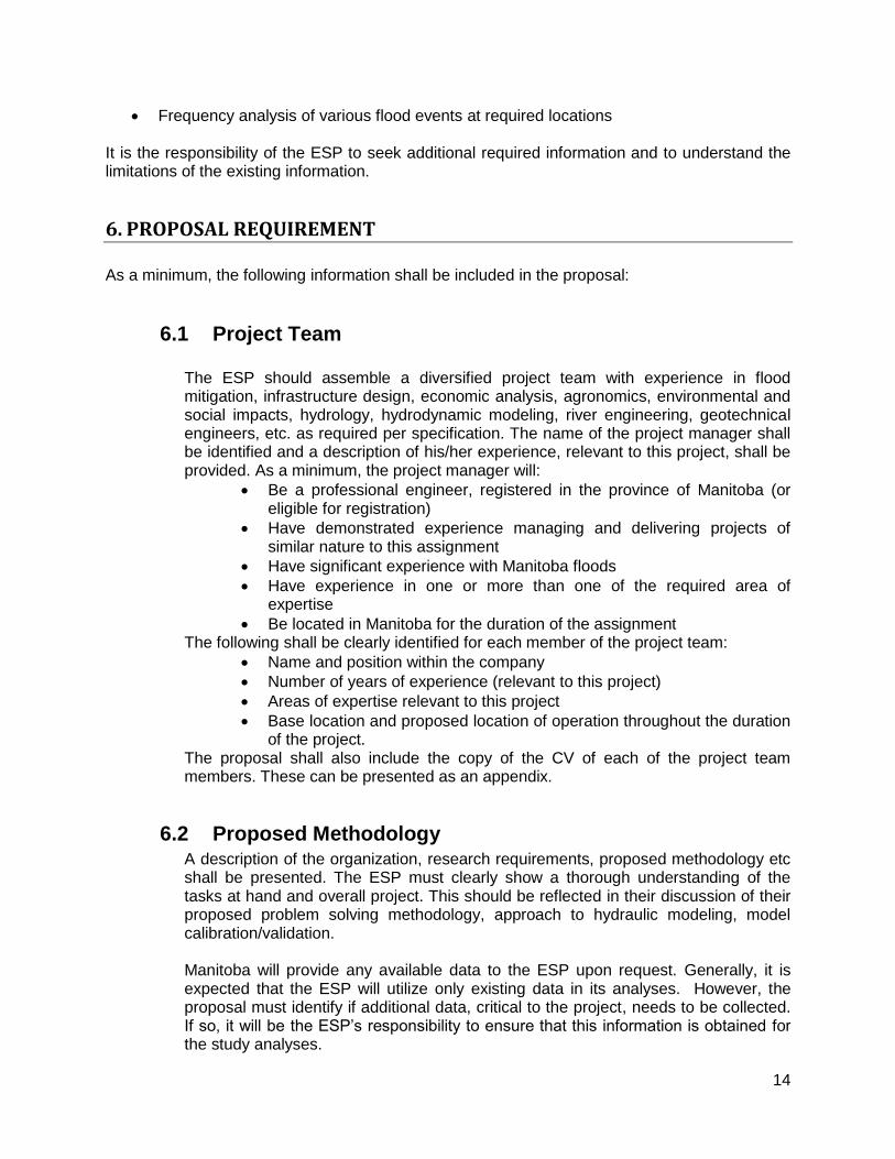
6.1 Project Team
The ESP should assemble a diversified project team with experience in flood mitigation, infrastructure design, economic analysis, agronomics, environmental and social impacts, hydrology, hydrodynamic modeling, river engineering, geotechnical engineers, etc. as required per specification. The name of the project manager shall be identified and a description of his/her experience, relevant to this project, shall be provided. As a minimum, the project manager will:
Be a professional engineer, registered in the province of Manitoba (or eligible for registration)
Have demonstrated experience managing and delivering projects of similar nature to this assignment
Have significant experience with Manitoba floods
Have experience in one or more than one of the required area of expertise
Be located in Manitoba for the duration of the assignment The following shall be clearly identified for each member of the project team:
Name and position within the company
Number of years of experience (relevant to this project)
Areas of expertise relevant to this project
Base location and proposed location of operation throughout the duration of the project.
The proposal shall also include the copy of the CV of each of the project team members. These can be presented as an appendix.
6.2 Proposed Methodology A description of the organization, research requirements, proposed methodology etc shall be presented. The ESP must clearly show a thorough understanding of the tasks at hand and overall project. This should be reflected in their discussion of their proposed problem solving methodology, approach to hydraulic modeling, model calibration/validation.
Manitoba will provide any available data to the ESP upon request. Generally, it is expected that the ESP will utilize only existing data in its analyses. However, the proposal must identify if additional data, critical to the project, needs to be collected. If so, it will be the ESP’s responsibility to ensure that this information is obtained for the study analyses.

15
The ESP is advised that Manitoba considers public input a critical component of the study. Therefore, the proposal must present a public consultation strategy for this project. The ESP must solicit input from the public to learn from their experience and local observations. The proposed public consultation strategy must also be outlined in the proposed project tasks and schedule.
The proposal must clearly indicate the project management approach the ESP intends to implement throughout the duration of this project (i.e., provision of Project Management Plan). Identification of risks and how these will be mitigated must be noted.
6.3 Detailed Work Plan A detailed work plan, at a minimum, identifies the following:
Breakdown of individual tasks to be undertaken
Staff assigned to those tasks (identify number of hours allotted to each team member, per task); including any sub-consultants
Identification of milestones and deliverables, including completion dates
Project schedule
Project cost breakdown A detailed cost breakdown that identifies the tasks to be undertaken, the project team members associated with each task, and the total man-hours associated with each task shall be provided
6.4 Example of similar work In the proposal, the ESP shall briefly describe a minimum two projects of a similar nature to this project, each done for different clients that their firm and their proposed project team members have successfully completed. Accompanying this description shall be the client’s name, contact person, phone number, postal and email address.
6.5 Submission Address and Deadline The ESP shall submit eight (8) hard copies of their Proposal and one electronic copy of the proposal in pdf format no later than July 6, 2012, 12:00 Noon, CDT to:
Fisaha Unduche Manitoba Infrastructure and Transportation Box 19, 200 Saulteaux Crescent, Winnipeg, MB R3J 3W3 Email: [email protected] Phone: (204)-945 6988 Fax: (204)-945 7419
As well, all inquiries related to this RFP are to be directed, in writing, to the above address.
16
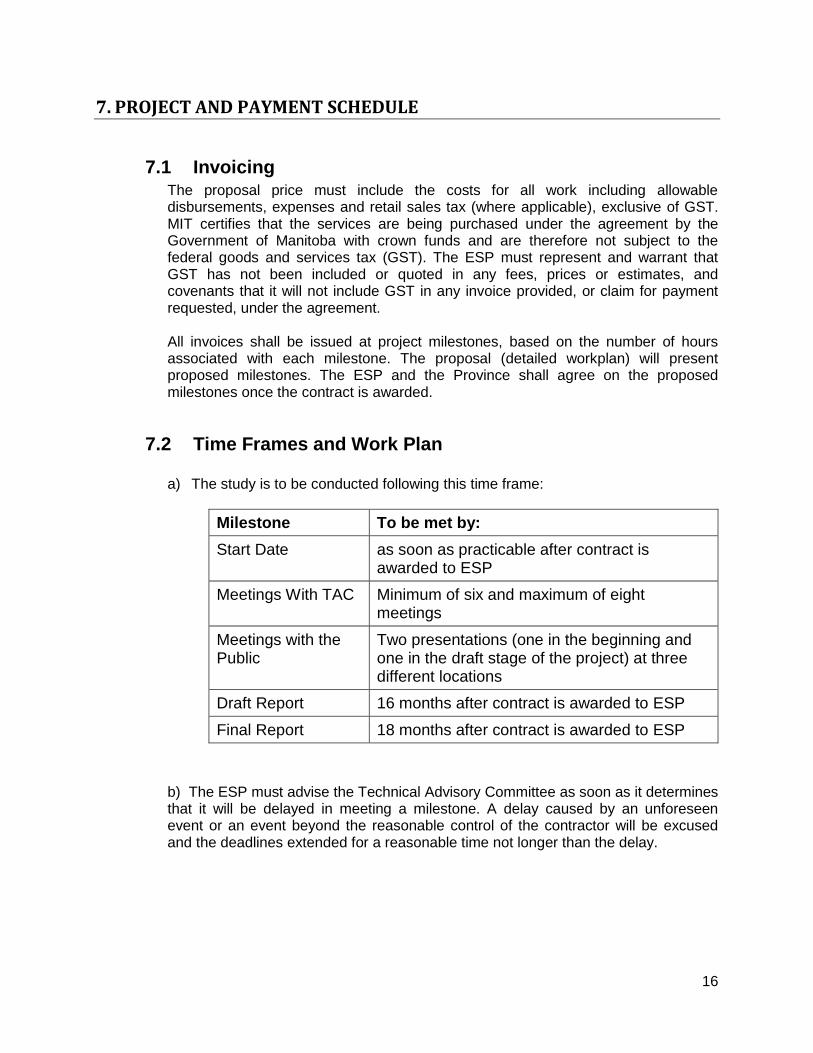
7. PROJECT AND PAYMENT SCHEDULE
7.1 Invoicing The proposal price must include the costs for all work including allowable disbursements, expenses and retail sales tax (where applicable), exclusive of GST. MIT certifies that the services are being purchased under the agreement by the Government of Manitoba with crown funds and are therefore not subject to the federal goods and services tax (GST). The ESP must represent and warrant that GST has not been included or quoted in any fees, prices or estimates, and covenants that it will not include GST in any invoice provided, or claim for payment requested, under the agreement.
All invoices shall be issued at project milestones, based on the number of hours associated with each milestone. The proposal (detailed workplan) will present proposed milestones. The ESP and the Province shall agree on the proposed milestones once the contract is awarded.
7.2 Time Frames and Work Plan
a) The study is to be conducted following this time frame:
Milestone To be met by:
Start Date as soon as practicable after contract is awarded to ESP
Meetings With TAC Minimum of six and maximum of eight meetings
Meetings with the Public
Two presentations (one in the beginning and one in the draft stage of the project) at three different locations
Draft Report 16 months after contract is awarded to ESP
Final Report 18 months after contract is awarded to ESP
b) The ESP must advise the Technical Advisory Committee as soon as it determines that it will be delayed in meeting a milestone. A delay caused by an unforeseen event or an event beyond the reasonable control of the contractor will be excused and the deadlines extended for a reasonable time not longer than the delay.

17
8. OWNERSHIP OF INFORMATION
The ESP shall accept that all information, documents and materials (including but not limited to: computer model, data, reports, drawings, designs, photographs and other materials) produced by the ESP in provision of, or delivery of, the services required by this assignment, shall be the exclusive property of MIT and shall be delivered or assigned without cost to MIT when all services have been completely performed. The ESP shall not use, publish or disclose any information, documents and materials (including but not limited to: computer model, data, reports, drawings, designs, photographs and other materials) produced by the ESP in provision of, or delivery of, the services required by this assignment, without first obtaining written permission from MIT. . MIT shall have sole ownership of the copyright.
9. PROPOSAL EVALUATION AND SELECTION METHOD
The selection method will be based on review of the proposals using a price per point evaluation by the Technical Review Committee. Proposals that meet the mandatory requirements of this RFP will be evaluated in accordance to the following criteria and assigned corresponding points: 1. Methodology:
o Understanding of project requirements o Proposed methodology and recommended hydraulic/hydrologic software and models o Detailed work plan o Level of Innovation, approach/ideas
50 points 2. Project Team: Technical skills and experience
o Project Manager o Senior Hydraulic Engineer o Senior Hydrologist o Senior Infrastructure Engineer o Senior Environmental Expert o Public Consultation Facilitator o Other Project Team members
30 points 3. Relevant Corporate Experience:
o Examples of two similar projects performed by the ESP 10 points
4. Project Team Location
10 points
Total 100 points
The proposals for this project shall be submitted in two parts, a Technical Proposal and a Financial Proposal. The first envelope shall contain the Technical Proposal which will outline the proposed work plan and project methodology. No financial information shall be contained in the Technical Proposal. The second sealed envelope shall contain the Financial Proposal.

18
The Technical Proposal submitted by the ESP will be assessed against the evaluation criteria identified above and assigned a technical point score. Following evaluation of the Technical Proposal, the Financial Proposal will be opened and a price per technical evaluation point will be calculated for each proponent. The price proposed by the ESP is divided by the technical point score received to determine the price-per-point. The proposal rated as the lowest price per point will be recommended forward. Manitoba reserves the right to reject the proposal when such rejection is in the best interest of Manitoba.