Reprojecting MODIS Images. Reasons why reprojection is desirable: 1.Removes Bowtie Artifacts...
38
Reprojecting MODIS Images
-
Upload
willis-robbins -
Category
Documents
-
view
219 -
download
0
Transcript of Reprojecting MODIS Images. Reasons why reprojection is desirable: 1.Removes Bowtie Artifacts...

Reprojecting MODIS Images

Reasons why reprojection is desirable:1. Removes Bowtie Artifacts2. Allows geographic overlays (e.g. coastline, city locations)3. Makes pretty pictures for publication on the web or in print4. Allows collocation with other sensors or measurements5. Prepares for ingest into GIS (e.g., GeoTIFF)
Good reprojection software is hard to find!• Needs to understand MODIS format• Should handle a variety of common projections• Should be relatively easy to use and well documented• Batch processing is a bonus• Zero cost (i.e., free) is the icing on the cake
Why Reprojection?

MS2GT (MODIS Swath to Grid Toolkit)Cost: Freehttp://nsidc.org/PROJECTS/HDFEOS/MS2GT/
HEG v0.6 (HDF-EOS to GeoTIFF converter)Cost: Freehttp://hdfeos.gsfc.nasa.gov/hdfeos/details.cfm?swID=55
HDFLook-MODISCost: Freehttp://www-loa.univ-lille1.fr/Hdflook/hdflook_gb.html
ENVI (Environment for Visualizing Images)Cost: $$$http://www.researchsystems.com/envi/
Software for Reprojecting MODIS Images

• Developed at National Snow and Ice Data Center (NSIDC) by Terry Haran and Ken Knowles.
• Based on mapx library routines that have been well tested.
• Accounts for multiple lines per earth scan.
• Comes with Perl scripts that automate reprojection procedure.
• You can call low level routines directly (ll2cr and fornav).
• Calling low-level routines gives the greatest flexibility on input and output formats.
• Flexible text file format for defining output map projection and datum.
• Gives high quality results when supplied with high quality input.
MS2GT (MODIS Swath to Grid Toolkit)

Sensor Projection (250 m pixels) Reprojected (250 m grid)

MS2GT Input and Output Formats
When calling the low level routines ll2cr and fornav:
Input
1. Image file (8, 16, 32-bit int or 32-bit float)
2. Corresponding latitude and longitude files (32-bit float)
3. Grid Parameter Definition file (ASCII text)
Output
1. Reprojected image file (same type as input image file)
2. Optional latitude and longitude files for reprojected grid
Note: No dependence on details of MODIS L1B HDF format

MS2GT Grid Parameter Definition (GPD) File
The GPD file specifies the size and type of the reprojected grid.
Example: Lambert Azimuthal Equal Area projected grid centered at 32S, 128E; 0.25 km resolution; 2550 columns and 3300 rows:
Map Projection: Azimuthal Equal-AreaMap Reference Latitude: -32.0Map Reference Longitude: 128.0Grid Map Units Per Cell: 0.25Grid Width: 2550.0Grid Map Origin Column: 1274.5Grid Height: 3300.0Grid Map Origin Row: 1649.5
Detailed reference: http://cires.colorado.edu/~knowlesk/ppgc.html

Albers Conic Equal-Area*Azimuthal Equal-Area*Cylindrical Equal-Area*Cylindrical EquidistantInterupted Homolosine Equal-AreaLambert Conic Conformal*MercatorMollweideOrthographicPolar Stereographic*Sinusoidal
* User can specify ellipsoid radius and eccentricity
MS2GT Projections Available

Map Projection: Lambert Conic Conformal EllipsoidMap Reference Latitude: 49.0 (first standard parallel)Map Second Reference Latitude: 77.0 (second standard parallel)Map Reference Longitude: -100.0 (natural origin longitude)Map Origin Latitude: 53.1 (false origin latitude)Map Origin Longitude: -80.5 (false origin longitude)Map Equatorial Radius: 6378.137 (WGS84 ellipsoid, km)Map Eccentricity: 0.081819190843 (WGS84 ellipsoid)Grid Map Units per Cell: 0.25 (resolution of projected grid, km)Grid Width: 2750.0 (columns in projected grid)Grid Height: 2125.0 (rows in projected gridGrid Map Origin Column: 1374.5 (column coordinate of grid center)Grid Map Origin Row: 1062.0 (row coordinate of grid center)
More complex example (GeoTIFF compatible):Lambert Conformal Conic with two standard parallels; WGS84 ellipsoid; centered at 53.1N, 80.5W; 0.25 km resolution; 2750 columns and 2125 rows:
GPD File Example

Reproject 250 meter resolution image to 250 meter grid.
Step 1: Convert lat/lon to col/row
$ ll2cr -v -f 5416 100 40 \ lat_5416x4000.dat lon_5416x4000.dat AquaSA.gpd AquaSA
Step 2: Convert lat/lon to col/row
$ fornav 1 -v -t f4 5416 100 40 \ AquaSA_cols_05416_00100_00000_40.img \ AquaSA_rows_05416_00100_00000_40.img \ band02_5416x4000.dat 2550 3300 band02_proj_2550x3300.dat
Default is weighted average of pixels mapped to each grid cell (nearest neighbor is optional).
MS2GT Script Example
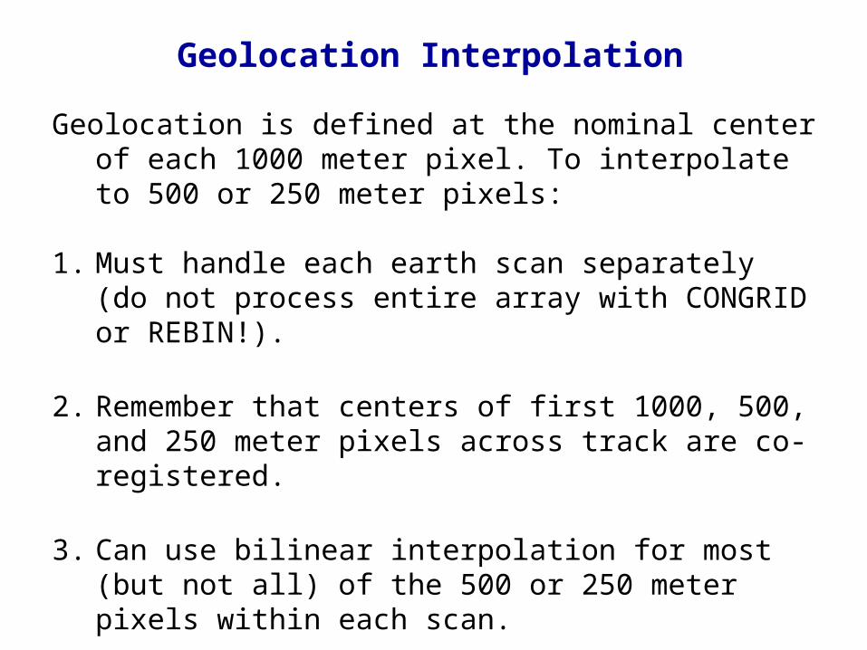
Geolocation is defined at the nominal center of each 1000 meter pixel. To interpolate to 500 or 250 meter pixels:
1. Must handle each earth scan separately (do not process entire array with CONGRID or REBIN!).
2. Remember that centers of first 1000, 500, and 250 meter pixels across track are co-registered.
3. Can use bilinear interpolation for most (but not all) of the 500 or 250 meter pixels within each scan.
4. Must use linear extrapolation for the 500 and 250 meter pixels at the edge of each earth scan.
Geolocation Interpolation

1000 meter pixels 500 meter pixels

Bottom Line
If the reprojected image looks strange,
it wasn’t done right!

MS2GT used routinely for SSEC browse images
True Color MODIS Images

Why True Color Images?
• Dramatic impact (more so than single band images)
• Excellent for PR purposes (press, public)
• Require comparatively little explanation
• Can use as base for displaying other products (e.g. fires)
• Daily 250 meter images in near real time are a first!
MODIS True Color Galleries:
http://rapidfire.sci.gsfc.nasa.gov/gallery/
http://terra.ssec.wisc.edu/~gumley/images.html

Mississippi Delta, Louisiana

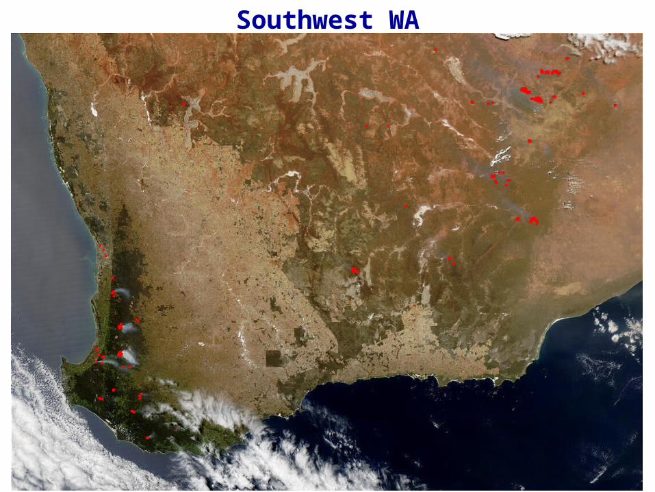
Southwest WA


Four Corners, USA

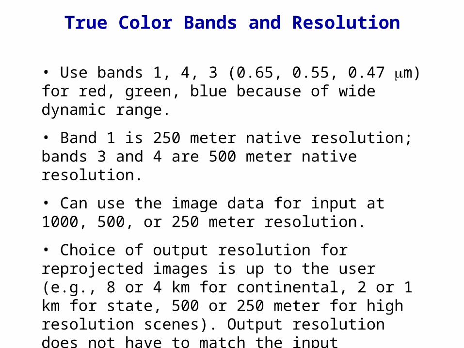
• Use bands 1, 4, 3 (0.65, 0.55, 0.47 m) for red, green, blue because of wide dynamic range.
• Band 1 is 250 meter native resolution; bands 3 and 4 are 500 meter native resolution.
• Can use the image data for input at 1000, 500, or 250 meter resolution.
• Choice of output resolution for reprojected images is up to the user (e.g., 8 or 4 km for continental, 2 or 1 km for state, 500 or 250 meter for high resolution scenes). Output resolution does not have to match the input resolution.
• Must use accurately interpolated geolocation data for reprojected images.
True Color Bands and Resolution

Bands 3 and 4 at 250 meter resolution
Use Band 1 to supply 250 meter resolution information for Bands 3 and 4, i.e.,
R = B1* / B1
R is spatial resolution ratio
B1* is band 1 @ 500 m interpolated to 250 m
B1 is band 1 @ 250 m
Then
B3 = B3* / R
B4 = B4* / R
B3*, B4
* are bands 3, 4 @ 500 m interpolated to 250 m
B3, B4 are bands 3, 4 @ 250 m

To interpolate 500 meter resolution image pixels to 250 meter resolution:
1. Must handle each earth scan separately (do not process entire array with CONGRID or REBIN!).
2. Remember that centers of first 1000, 500, and 250 meter pixels across track are co-registered.
3. Can use bilinear interpolation for most (but not all) of the 250 meter pixels within each scan.
4. Can use pixel replication for the 250 meter pixels at the edge of each earth scan.
Image Interpolation

True Color Enhancement: First Cut
Linear enhancement of at-sensor reflectance.
Advantages:
• Easy to code
Disadvantages:
• Clouds are washed out
• Difficult to achieve balance between red, green, blue
• Bluish haze always appears at the image edges
• Jacques Descloitres’ images look much better!


True Color Enhancement: Second Cut
Piecewise linear enhancement of corrected reflectance.
Advantages:
• Removes bluish haze
• Allows clouds to retain detail
• Balance between red, green, and blue is much improved
Disadvantages:
• Requires corrected reflectance algorithm from Jacques Descloitres (NASA release is pending)


Corrected Reflectance Algorithm
• A simplified pixel-by-pixel atmospheric correction scheme (not the same as MODIS surface reflectance product MOD09).
• Accounts for molecular scattering and for absorption by ozone, oxygen, and water vapor in conjunction with a low resolution terrain database.
• Removes haze from blue band.

Corrected Reflectance Script
To create corrected reflectance files at 500 m and 250 m resolution:
$ ln -fs MOD021KM.A2002228.0745.hdf MOD021KM.hdf$ ln -fs MOD02HKM.A2002228.0745.hdf MOD02HKM.hdf$ ln -fs MOD02QKM.A2002228.0745.hdf MOD02QKM.hdf$ ln -fs MOD03.A2002228.0745.hdf MOD03.hdf$ export CORR_REFL=$HOME/corr_refl$ export ANCPATH $CORR_REFL$ $CORR_REFL/corr_refl -f -v -250m \ MOD02HKM.hdf MOD02QKM.hdf MOD021KM.hdf -of=qkm.hdf$ $CORR_REFL/corr_refl -f -v -500m \ MOD02HKM.hdf MOD02QKM.hdf MOD021KM.hdf -of=hkm.hdf
Output HDF files (qkm.hdf, hkm.hdf) contain three SDS arrays:
CorrRefl_01, CorrRefl_03, CorrRefl_04
containing corrected reflectance scaled by a factor of 0.0001.

TOA reflectance Corrected reflectance

Corr. Refl. Brightness
-0.01 0
0.10 90
0.45 210
1.10 255
Same curve is applied tocorrected reflectance from bands 1, 3, 4.
Piecewise Linear Enhancement Curve
Final step is to convert to HLS space and increase saturation by 25% and lightness by 5%.

Applications of True Color Images
• Regional scale images (e.g. SouthWest WA) at 0.5 or 1 km resolution
• Continental scale images (e.g. Australia clear sky composite for last 7 days) at 1, 2, or 4 km resolution
• Local scale images (e.g. Over an active fire) at 0.25 km resolution
All of these can be produced in near real time!

Ordering Global MODIS Data

ECS Data Pool
ftp://g0dps01u.ecs.nasa.gov/
Delay: About 24 hours
Interface: Anonymous FTP
Holdings: At least 30 days global
Platforms: Terra and Aqua
Metadata: Quicklooks, XML files
Registration: Not required
• Manual search and download
• Degree of difficulty 1.0/5.0

DAAC Search and Order
http://daac.gsfc.nasa.gov/data/
Delay: About 24 hours
Interface: Web
Holdings: Entire global archive
Platforms: Terra and Aqua
Metadata: .met files
Registration: Required
• One product per search
• FTP pull subject to delays (try FTP push instead)
• Degree of difficulty 3.0/5.0

http://redhook.gsfc.nasa.gov/~imswww/pub/imswelcome/plain.html
Delay: About 24 hours
Interface: Web
Holdings: Entire global archive
Platforms: Terra and Aqua
Metadata: .met files
Registration: Required
• Multiple products per search
• FTP pull subject to delays (use push instead)
• Degree of difficulty 5.0/5.0
Enhanced Data Gateway


![SPHERICAL IMAGE REPROJECTION - Gexcel · JRC 3D Reconstructor Spherical image reprojection ... C] a Cylinder camera 129 from ... Pan scale [m] Ro tation type](https://static.fdocuments.in/doc/165x107/5c66f88509d3f2f91c8d0c65/spherical-image-reprojection-jrc-3d-reconstructor-spherical-image-reprojection.jpg)