Reprocessing an Industry 3-D Seismic Dataset for ...
4
Saskatchewan Geological Survey 1 Summary of Investigations 2006, Volume 1 Reprocessing an Industry 3-D Seismic Dataset for Precambrian Basement Characterization in South-Central Saskatchewan A. Jhajhria 1 and I. Morozov 1 Jhajhria, A. and Morozov, I. (2006): Reprocessing an industry 3-D seismic dataset for Precambrian basement characterization in south-central Saskatchewan; in Summary of Investigations 2006, Volume 1, Saskatchewan Geological Survey, Sask. Industry Resources, Misc. Rep. 2006-4.1, CD-ROM, Paper A-3, 4p. Abstract The Beaver Ranch 3-D seismic dataset from Olympic Seismic Ltd. has wide geographic coverage in south-central Saskatchewan and is being reprocessed to provide detailed characterization of the Precambrian basement. Data processing is currently ongoing, with the survey geometry database loaded, and data loading and sorting underway. The processing results will be compared to potential-field mapping and the results from 2-D seismic studies, leading to better understanding of the subsurface in southern Saskatchewan and of basement influence on structures linked to petroleum entrapment and migration. Keywords: seismic, 3-D, Precambrian, basement, structure. 1. Introduction Basement structure is recognized to play a major role in hydrocarbon migration and entrapment in the Phanerozoic strata of southern Saskatchewan. Two types of processes contribute to this influence: 1) development of porosity related to migration of brines along basement-related faults and fracture zones, and 2) development of structural traps in strata overlying basement highs. Regional analysis of structural elements within the Williston Basin (Thomas, 1974; Brown and Brown, 1987; Kissling and Ehrets, 1988 as cited in Potter and St. Onge, 1991) revealed pervasive northeast- and northwest- trending structural lineaments. Thomas (1974) suggested that simple shear involving the basement could create fracturing, faulting, and downwarps along zones of basement weakness and explain the present structural configuration of the Williston Basin. Brown and Brown (1987) suggested that pure shear along a wrench fault system with both vertical and horizontal displacements could create normal faults, grabens, half-grabens, and horsts found along block boundaries. Intersections of northwest-trending and secondary northeast-trending faults create structural lows and highs, the latter forming closures that may trap hydrocarbons in suitable Phanerozoic strata. The key objective of this ongoing project is to extrapolate the constraints gleaned from detailed mapping of the basement in a localized area covered by a large 3-D seismic survey into a more regional perspective. Our approach focuses on: 1) Reprocessing and interpreting the 3-D dataset, applying the available high-resolution imaging techniques (high- frequency signal enhancement, pre-stack migration) using all the available constraints (well logs, lithological interpretations, and subsurface mapping). 2) Characterization of the relationships between seismic and potential-field mapping of the basement (Li et al., 2005). 3) Geostatistical characterization of the basement, estimation of the directions of dominant structural heterogeneity, and use of this information in correlations with 2-D seismic and potential-field imaging. 4) Seeking ways to improve the constraints from regional 2-D seismic mapping, extraction of several 2-D lines from the 3-D dataset, processing them independently and examination of the effects of the out-of-plane structures. Reprocessing of such a large dataset at the University of Saskatchewan has become possible due to recent upgrading of the computing infrastructure, including a number of dual-processor workstations, two cluster systems dedicated to geophysical data processing, three RAID file servers, and a stereoscopic 3-D visualization lab using the Geowall approach (URL http://www:geowall.org). 1 Department of Geological Sciences, University of Saskatchewan, 114 Science Place, Saskatoon, SK S7N 5E2; E-mail: [email protected].
Transcript of Reprocessing an Industry 3-D Seismic Dataset for ...

Saskatchewan Geological Survey 1 Summary of Investigations 2006, Volume 1
Reprocessing an Industry 3-D Seismic Dataset for Precambrian Basement Characterization in South-Central Saskatchewan
A. Jhajhria 1 and I. Morozov 1
Jhajhria, A. and Morozov, I. (2006): Reprocessing an industry 3-D seismic dataset for Precambrian basement characterization in south-central Saskatchewan; in Summary of Investigations 2006, Volume 1, Saskatchewan Geological Survey, Sask. Industry Resources, Misc. Rep. 2006-4.1, CD-ROM, Paper A-3, 4p.
Abstract The Beaver Ranch 3-D seismic dataset from Olympic Seismic Ltd. has wide geographic coverage in south-central Saskatchewan and is being reprocessed to provide detailed characterization of the Precambrian basement. Data processing is currently ongoing, with the survey geometry database loaded, and data loading and sorting underway. The processing results will be compared to potential-field mapping and the results from 2-D seismic studies, leading to better understanding of the subsurface in southern Saskatchewan and of basement influence on structures linked to petroleum entrapment and migration.
Keywords: seismic, 3-D, Precambrian, basement, structure.
1. Introduction Basement structure is recognized to play a major role in hydrocarbon migration and entrapment in the Phanerozoic strata of southern Saskatchewan. Two types of processes contribute to this influence: 1) development of porosity related to migration of brines along basement-related faults and fracture zones, and 2) development of structural traps in strata overlying basement highs.
Regional analysis of structural elements within the Williston Basin (Thomas, 1974; Brown and Brown, 1987; Kissling and Ehrets, 1988 as cited in Potter and St. Onge, 1991) revealed pervasive northeast- and northwest-trending structural lineaments. Thomas (1974) suggested that simple shear involving the basement could create fracturing, faulting, and downwarps along zones of basement weakness and explain the present structural configuration of the Williston Basin. Brown and Brown (1987) suggested that pure shear along a wrench fault system with both vertical and horizontal displacements could create normal faults, grabens, half-grabens, and horsts found along block boundaries. Intersections of northwest-trending and secondary northeast-trending faults create structural lows and highs, the latter forming closures that may trap hydrocarbons in suitable Phanerozoic strata.
The key objective of this ongoing project is to extrapolate the constraints gleaned from detailed mapping of the basement in a localized area covered by a large 3-D seismic survey into a more regional perspective. Our approach focuses on:
1) Reprocessing and interpreting the 3-D dataset, applying the available high-resolution imaging techniques (high-frequency signal enhancement, pre-stack migration) using all the available constraints (well logs, lithological interpretations, and subsurface mapping).
2) Characterization of the relationships between seismic and potential-field mapping of the basement (Li et al., 2005).
3) Geostatistical characterization of the basement, estimation of the directions of dominant structural heterogeneity, and use of this information in correlations with 2-D seismic and potential-field imaging.
4) Seeking ways to improve the constraints from regional 2-D seismic mapping, extraction of several 2-D lines from the 3-D dataset, processing them independently and examination of the effects of the out-of-plane structures.
Reprocessing of such a large dataset at the University of Saskatchewan has become possible due to recent upgrading of the computing infrastructure, including a number of dual-processor workstations, two cluster systems dedicated to geophysical data processing, three RAID file servers, and a stereoscopic 3-D visualization lab using the Geowall approach (URL http://www:geowall.org).
1 Department of Geological Sciences, University of Saskatchewan, 114 Science Place, Saskatoon, SK S7N 5E2; E-mail: [email protected].

Saskatchewan Geological Survey 2 Summary of Investigations 2006, Volume 1
2. Reprocessing Beaver Ranch 3-D Seismic Dataset The Beaver Ranch 3-D seismic dataset used in this study was donated to the University of Saskatchewan by Olympic Seismic Ltd. (Figure 1). A total of 15,028 shots were fired in an area extending about 26 km east-west and 14 km north-south (Figure 1). The nominal receiver spacing was 67 m, and cross-line separation was 402 m. The average shot point spacing was 94.75 m, which amounted to roughly 1.5 times the receiver spacing.
One kilogram dynamite sources were used, with recording lengths of 3 s at 2 ms sampling intervals. The number of live channels per shot varied from 476 to 1420, with a nominal value of 900.
Currently, the study is at the stage of dataset preparation, data loading, quality control, and preprocessing. These operations require extensive interactive editing of project metadata and checking for errors. Seismic-processing package Promax 3-D (Landmark Graphics) is being used.
For Promax, the geometry data (from survey reports, observers, and chaining notes) were divided into three database tables describing the receiver distribution, source positions, and shooting patterns. The receiver table contains the receiver line numbers, station number, and geographic co-ordinates. The source table contains the information about shot-point positions, co-ordinates, FFID (field-file index number), uphole times, numbers of live channels, and also links to the corresponding patterns. Finally, the pattern table contains information about the subset of receivers that are active for each shot, and also the corresponding recording channel numbers. Generally, five to six shots were fired using the same receiver spread (short northeast-southwest diagonal segments between the receiver lines in Figure 1).
Figure 1 - Survey base map showing receiver (running north-south) and source (running northeast-southwest) lines.
Saskatchewan Geological Survey 3 Summary of Investigations 2006, Volume 1
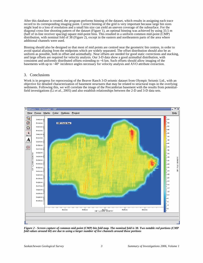
After this database is created, the program performs binning of the dataset, which results in assigning each trace record to its corresponding imaging point. Correct binning of the grid is very important because large bin sizes might lead to a loss of resolution and a small bin size can yield an uneven coverage of the subsurface. For the diagonal cross-line shooting pattern of the dataset (Figure 1), an optimal binning was achieved by using 33.5 m (half of in-line receiver spacing) square mid-point bins. This resulted in a uniform common mid-point (CMP) distribution, with nominal fold of 38 (Figure 2), except in the eastern and northeastern parts of the area where additional channels were used.
Binning should also be designed so that most of mid points are centred near the geometric bin centres, in order to avoid spatial aliasing from the midpoints which are widely separated. The offset distribution should also be as uniform as possible, both in offset and azimuthally. Near offsets are needed for good static corrections and stacking, and large offsets are required for velocity analysis. Our 3-D data show a good azimuthal distribution, with consistent and uniformly distributed offsets extending to ~6 km. Such offsets should allow imaging of the basements with up to ~40° incidence angles necessary for velocity analysis and AVO attribute extraction.
3. Conclusions Work is in progress for reprocessing of the Beaver Ranch 3-D seismic dataset from Olympic Seismic Ltd., with an objective for detailed characterization of basement structures that may be related to structural traps in the overlying sediments. Following this, we will correlate the image of the Precambrian basement with the results from potential-field investigations (Li et al., 2005) and also establish relationships between the 2-D and 3-D data sets.
Figure 2 - Screen capture of common mid-point (CMP) bin fold map. The nominal fold is 38. Two notable red portions (CMP fold values around 60) are due to using a larger number of live channels around those portions

Saskatchewan Geological Survey 4 Summary of Investigations 2006, Volume 1
4. Acknowledgments This research is made possible through a grant from Saskatchewan Industry and Resources to the University of Saskatchewan and, in part, by Canada NSERC Discovery Grant RGPIN261610-03.
5. References Brown, D.L. and Brown, D.L. (1987).:Wrench-style deformation and paleostructural influence on sedimentation in
and around a cratonic basin; in Longman, M.W. (ed.), Williston Basin: Anatomy of a Cratonic Oil Province, Rky. Mtn. Assoc. Geol., Denver, p37-70.
Li, J., Morozov, I.B., and Chubak, G. (2005): Potential-field investigations of the Williston Basin basement; in Summary of Investigations 2005, Volume 1, Saskatchewan Geological Survey, Sask. Industry Resources, Misc. Rep. 2005-4.1, CD-ROM, Paper A-5, 11p.
Potter, D. and St. Onge, A. (1991): Minton Pool, south-central Saskatchewan: A model for basement induced structural and stratigraphic relationships; in Christopher, J.E. and Haidl, F.M. (eds.), Sixth International Williston Basin Symposium, Sask. Geol. Soc., Spec. Publ. No. 11, p21-33.
Thomas, G.E. (1974). Lineament-block tectonics, Williston-Blood Creek Basin; Amer. Assoc. Petrol. Geol. Bull., v58, p1305-1322.